
Downscaling Microwave Soil Moisture Products with SM-RDNet for Semiarid Mining Areas


 ,
,
Abstract
:1. Introduction
2. Materials
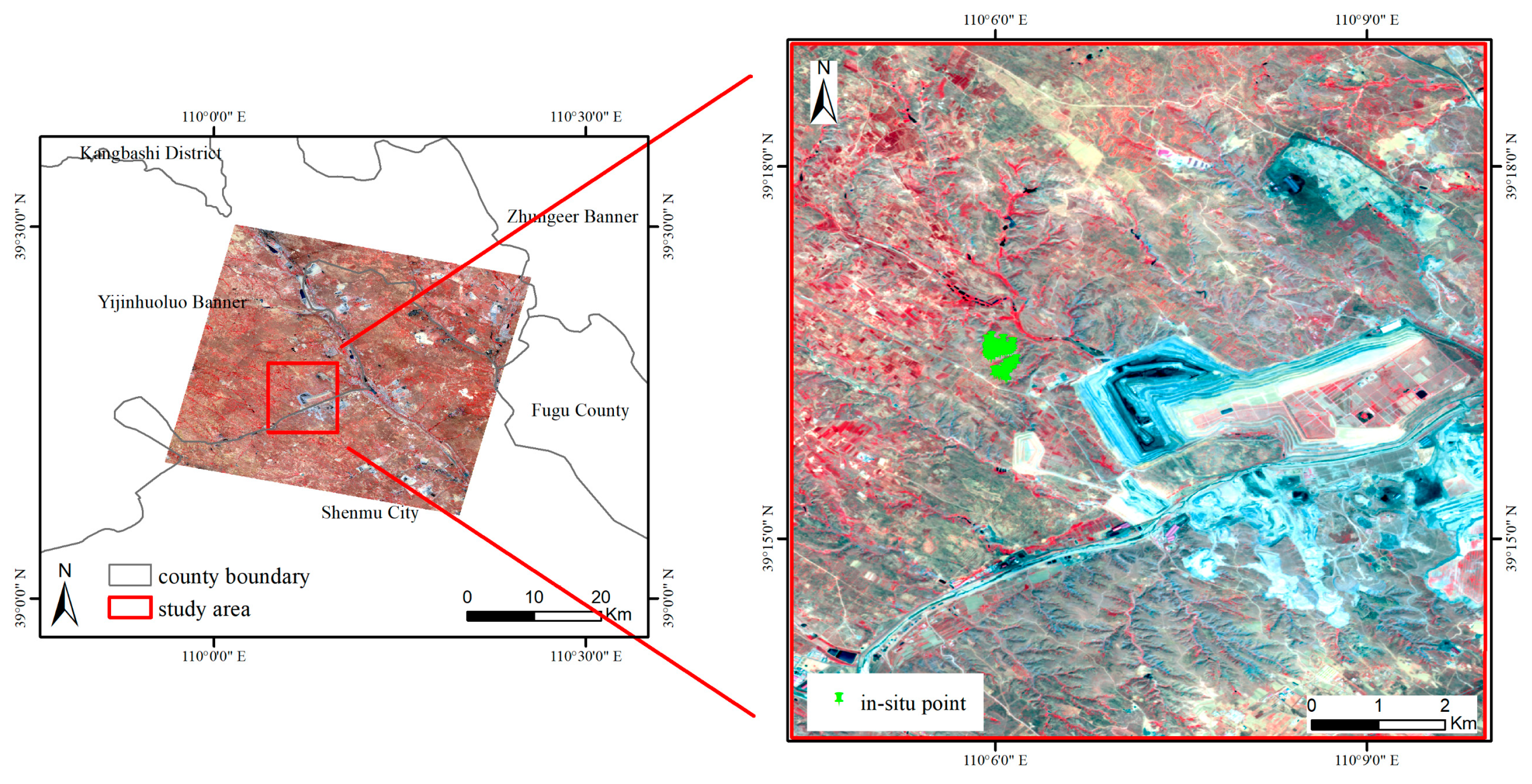
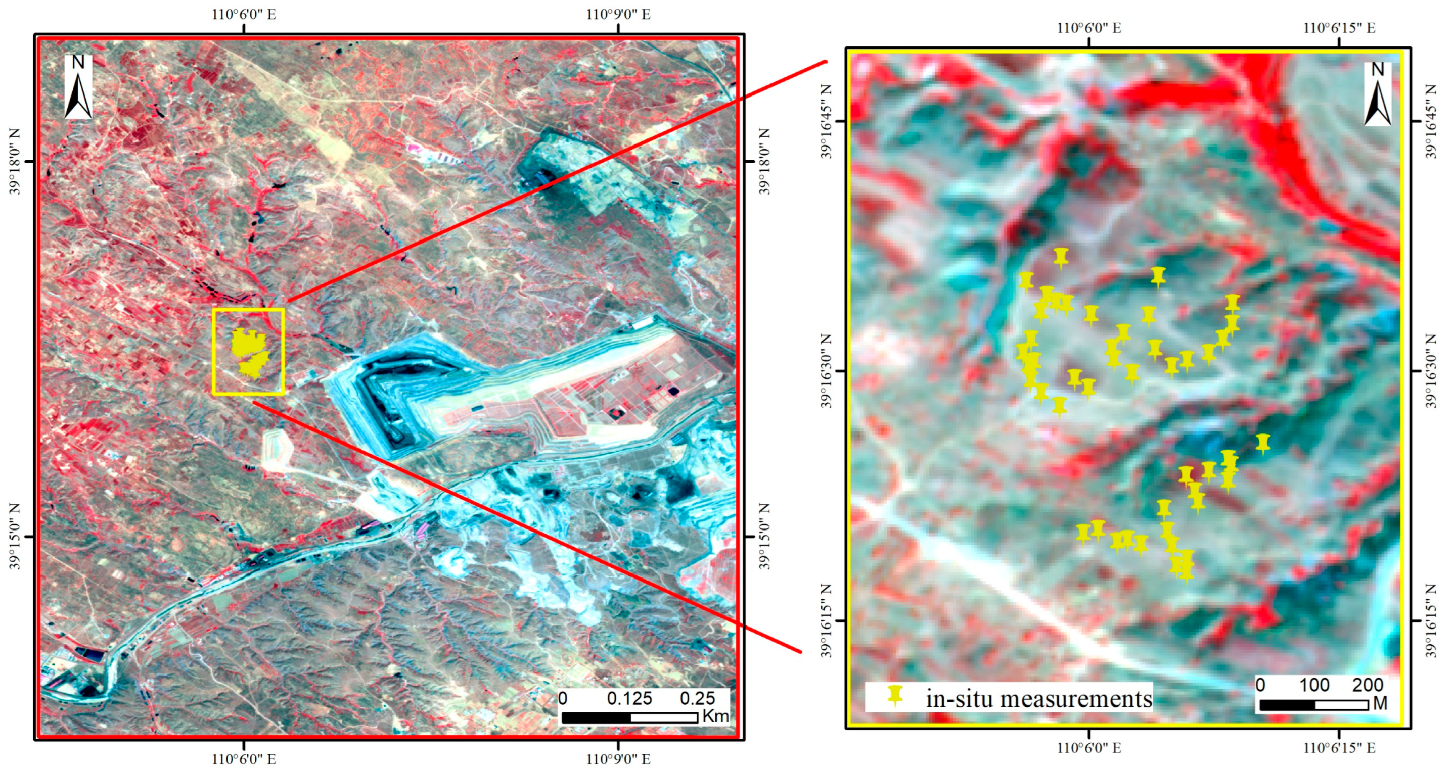
2.1. Study Area
2.2. Data
2.2.1. SPL2SMAP_S SM Products
2.2.2. Sentinel-2 Images
2.2.3. Vegetation Index
2.2.4. Topographic Data
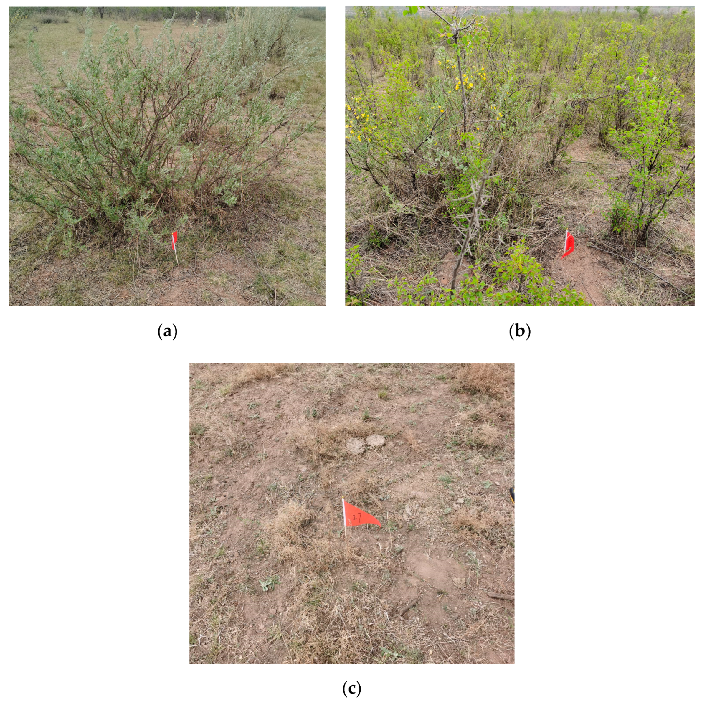
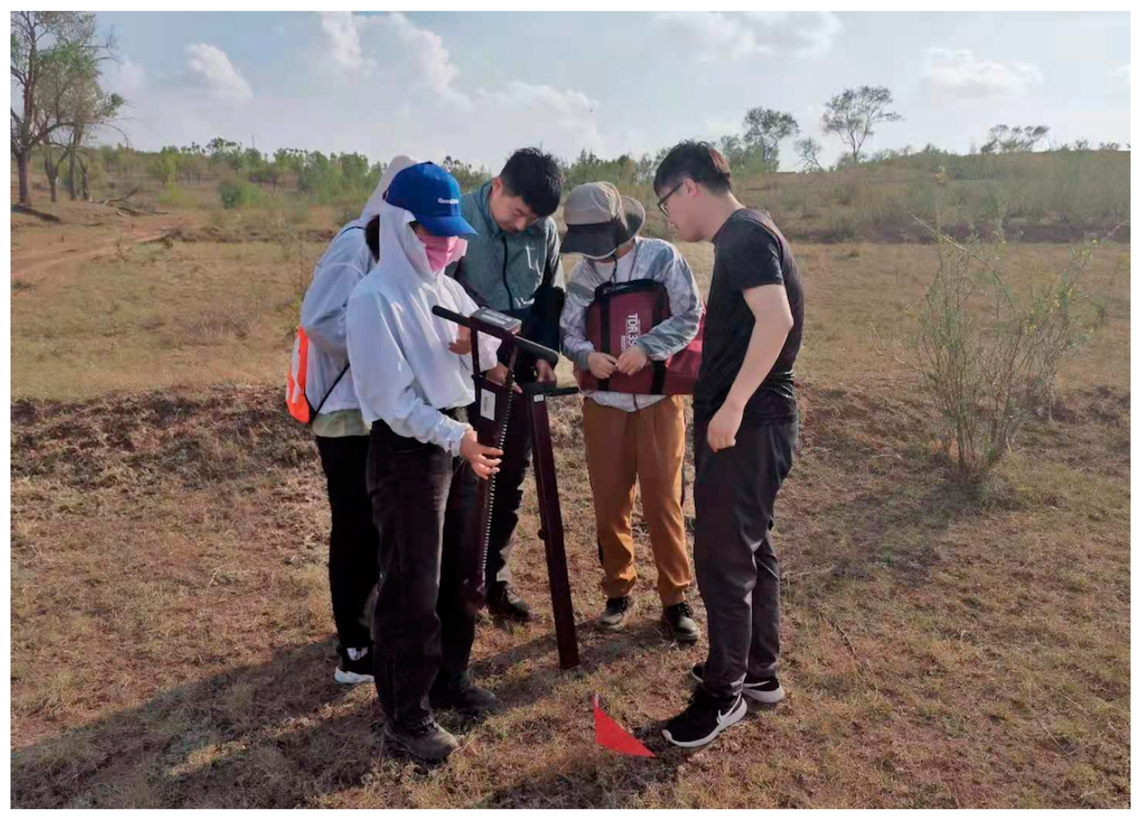
2.2.5. In Situ Measurement Data
3. Methods
3.1. SM-RDNet
3.2. Downscaling Strategy
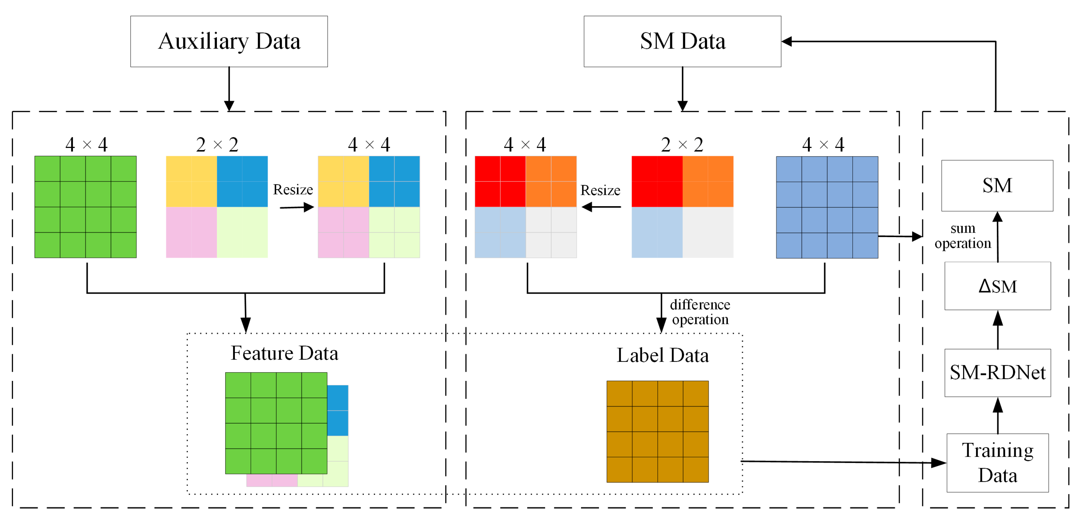
- Preparation of training dataset. The training dataset consists of a label dataset and a feature dataset. The label dataset is the residual value (∆SM) between the SM data with a higher spatial resolution and that with a lower spatial resolution. This process requires the SM product with a lower spatial resolution to be resized to have a higher spatial resolution to perform difference calculation. The feature dataset is obtained by resampling the auxiliary data to the same spatial resolution as the SM data, including Sentinel-2 reflectances, NDVI, elevation and slope. It should be noted that the high-spatial-resolution SM data in the first loop of downscaling is generated by conducting the nearest-neighbor interpolation on the original SM products. For the other loop of downscaling, the SM data we used is the SM predictions from the previous downscaling loops.
- Training of SM-RDNet model. The training dataset is input into the SM-RDNet to generate a prediction model. The prediction model is consecutively trained 200 times and each training evaluates the prediction model by the statistical evaluation indexes root mean square error (RMSE) and coefficient of determination (R2) based on the truth SM values. As the number of training increases, the predicted SM accuracy gradually improves and eventually stabilizes. Finally, the best prediction model is selected. In our experiments, each prediction model has an R2 greater than 0.85 and an RMSE less than 0.004 m3/m3 with respect to the truth SM value.
- Downscaling of SPL2SMAP_S SM products. The auxiliary data are resampled to the target spatial resolution, while the auxiliary data of the feature dataset with the higher spatial resolution are resized to the same dimension, and the two datasets are input into the trained SM-RDNet model to obtain ∆SM. The obtained ∆SM is added to the SM product with the high spatial resolution in the label dataset to obtain the estimated SM values.
- The expansion of spatial resolution in progressively downscaling. To reduce the information loss, the SM with a close resolution to the target is obtained through several downscaling processes. The expansion multiplier in each step is calculated as Equation (2).where Rn_after and Rn_befor are the spatial resolutions after and before the n-th downscaling, respectively, and K is the expansion multiplier.Rn_after = Rn_before/K,In this paper, the expansion multipliers are 3, 3, 3 and 5 in turn for downscaling the 3 km SPL2SMAP_S SM product into the 7.4 m product, which is close to the target spatial resolution (10 m), and are 3, 3 and 5 in turn for downscaling the 1 km SPL2SMAP_S SM products.
- Iterative downscaling process. Each downscaling process includes the training and prediction of the model. In the first training of the model, the higher resolution SM data in the ∆SM (label data) calculation process is generated by conducting the nearest-neighbor interpolation on the original SM products, while the lower resolution SM data is the original SM products. In the n-th training of the model, the higher resolution SM data in the ∆SM (label data) calculation process are the SM predicted results obtained from the (n − 1)-th downscaling, while the lower resolution SM data are the SM predicted results obtained from the (n − 2)-th downscaling. The auxiliary data are used as feature data after the same processing as in step 2. In the n-th model prediction process, the target resolution is calculated by step 4. The auxiliary data processed to the same resolution as the target will be used as input to the prediction model. The output ∆SM is added to the SM predicted from the (n − 1)-th downscaling to obtain the estimated SM values. In particular, the reason we chose iterative downscaling is that Xu et al. showed that the iterative downscaling method performs better than directly downscaling SM products to the target resolution [61].
- When the downscaling is finished, the downscaled SM further needs a resampling to fit the target spatial resolution.
3.3. Accuracy Validation
4. Results
4.1. Performance of Downscaled SM Derived from 1 Km SPL2SMAP_S SM Products
4.2. Performance of Downscaled SM Derived from 3 Km SPL2SMAP_S SM Products
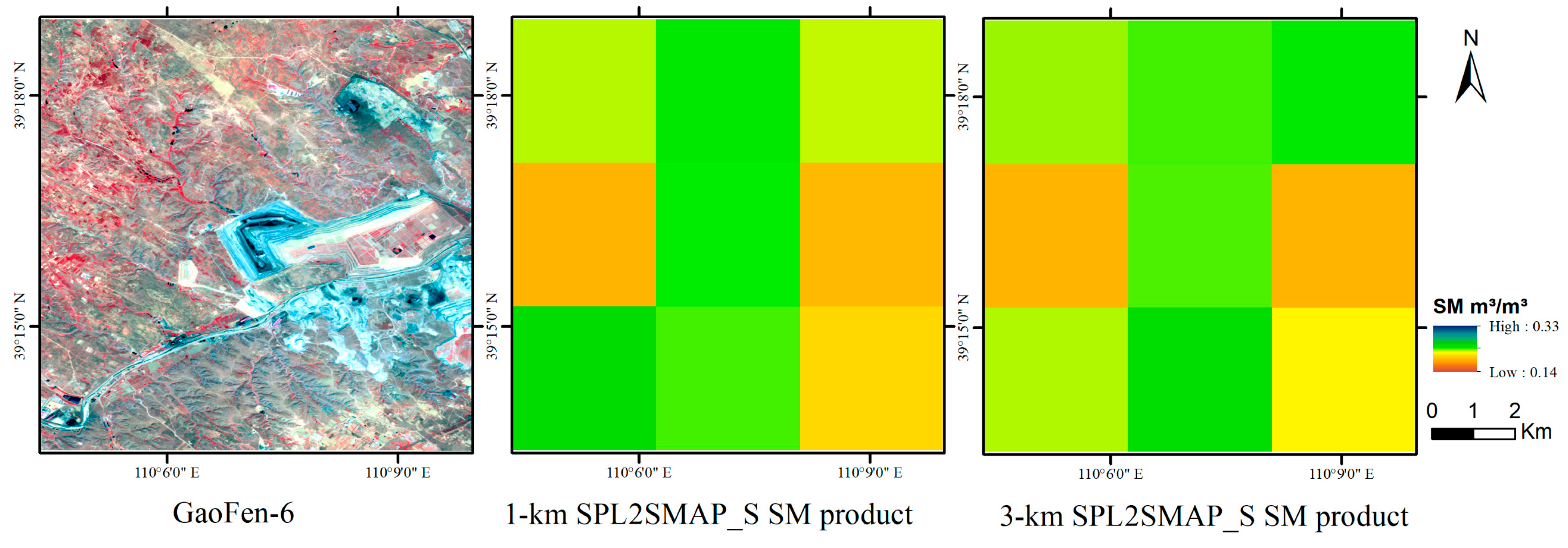
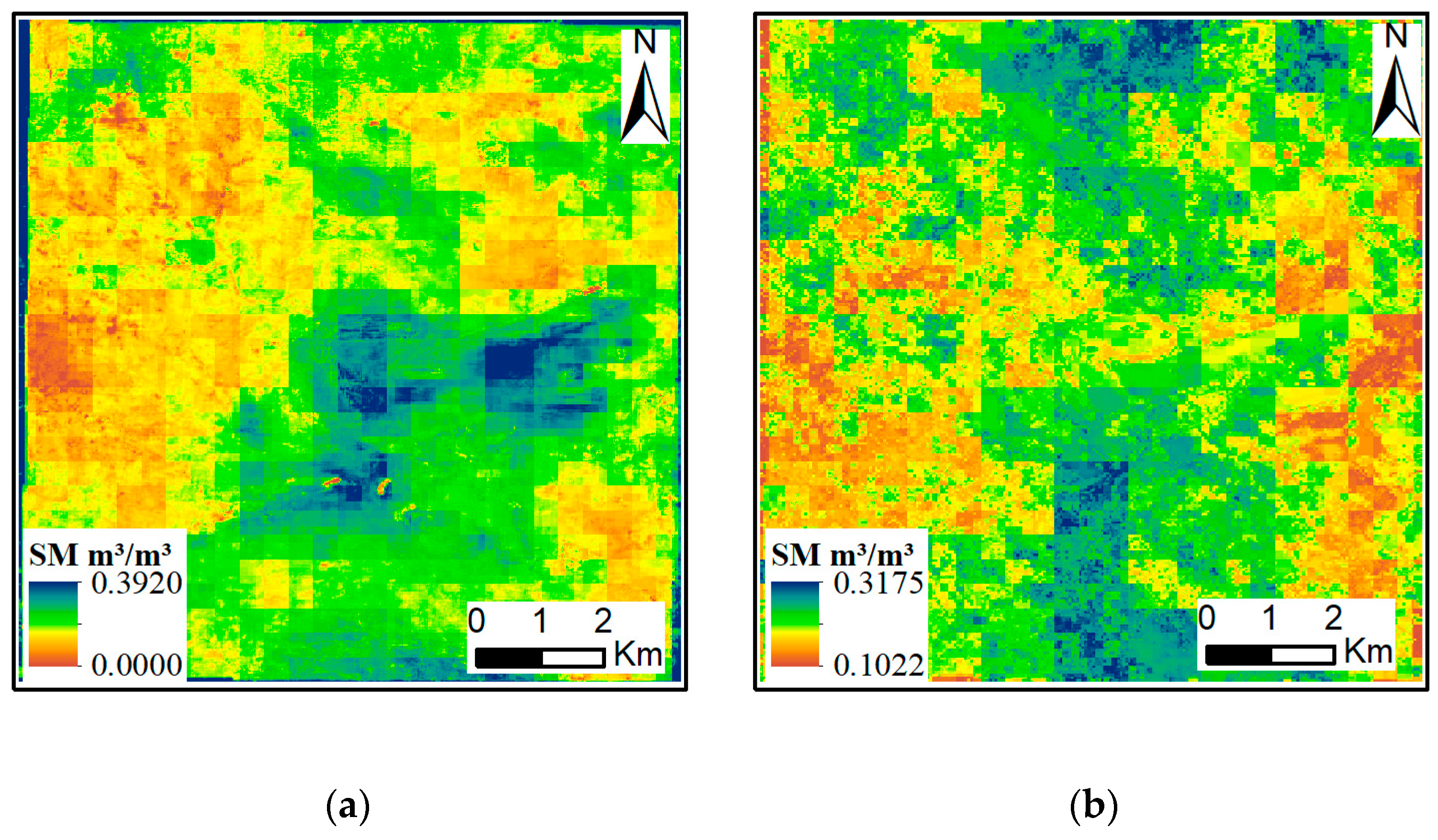
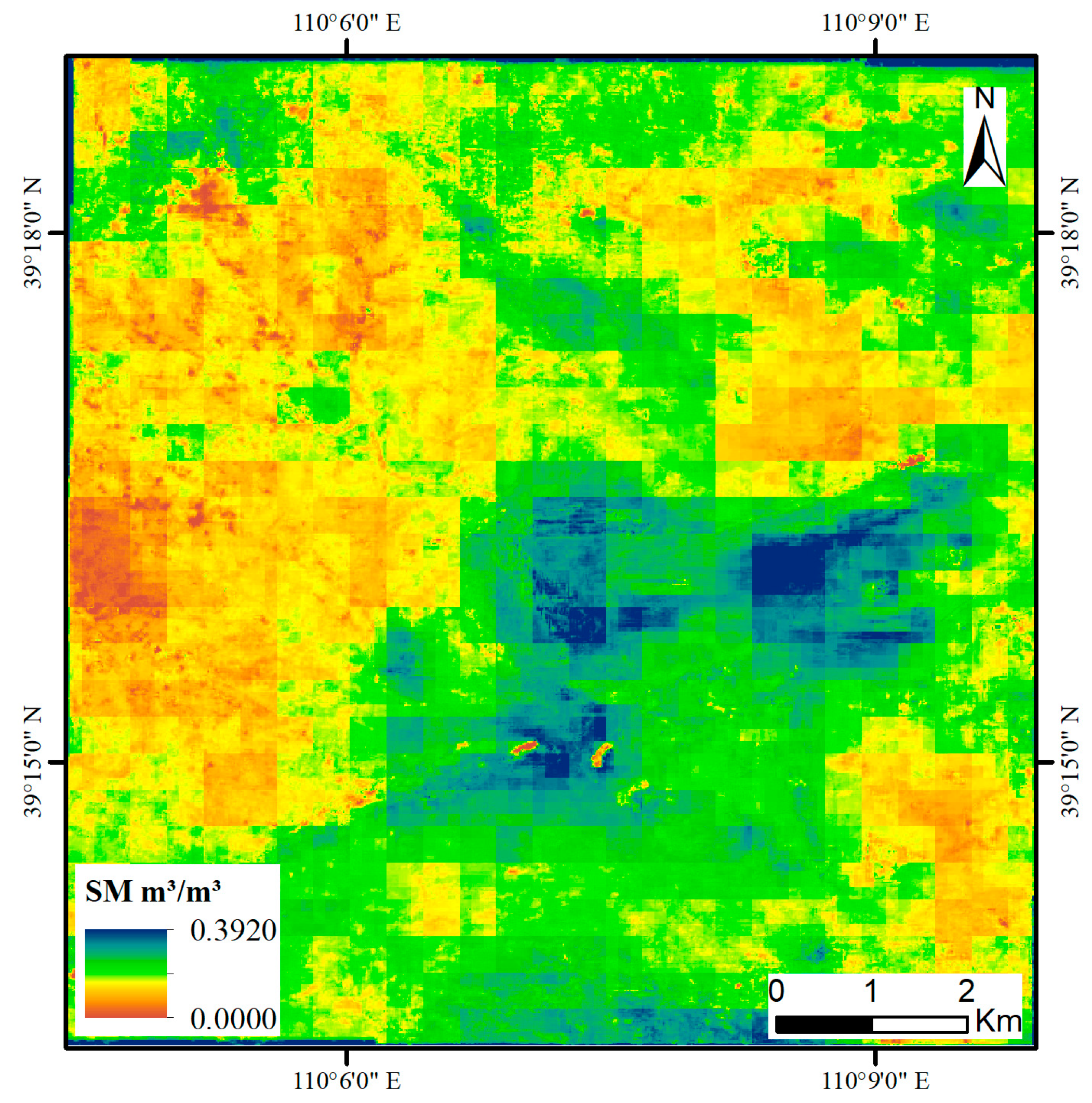
4.3. Spatial Patterns of Downscaled SM in Shangwan Area
5. Discussion
5.1. Overview of the Downscaling Methodology
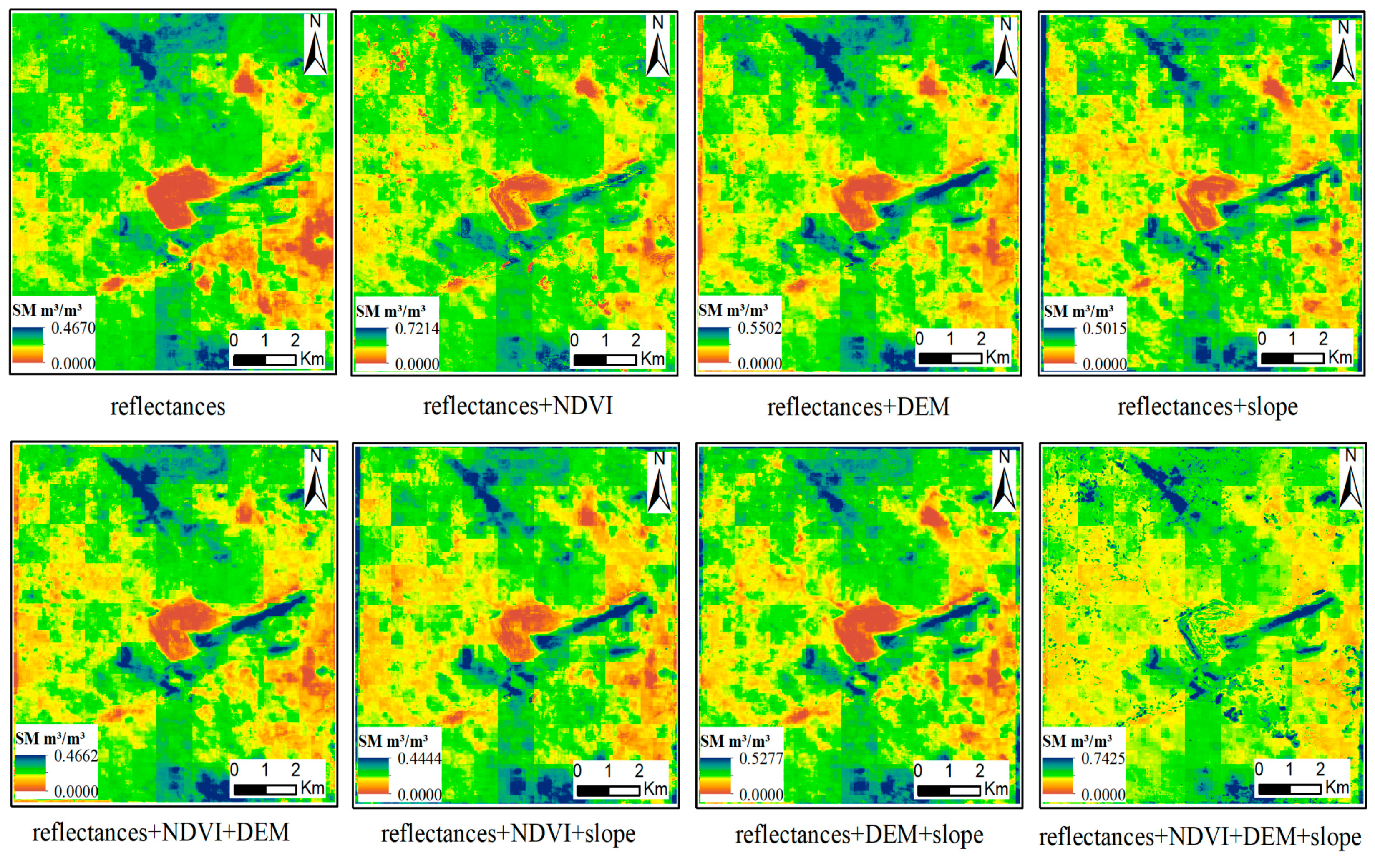
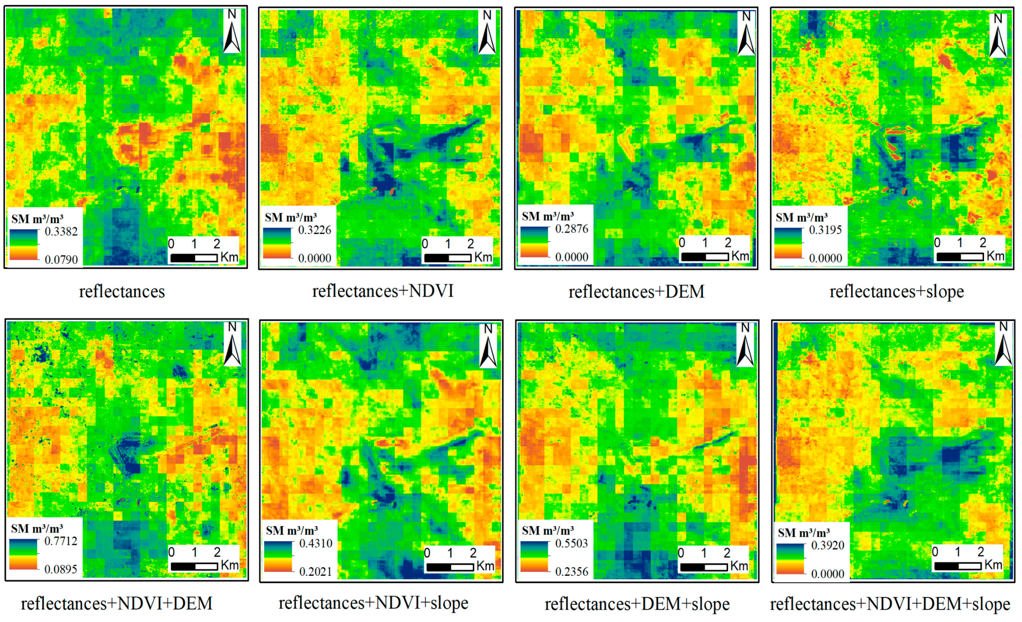
5.2. Role of Geoinformation in Improving the Accuracy of the Downscaled SM
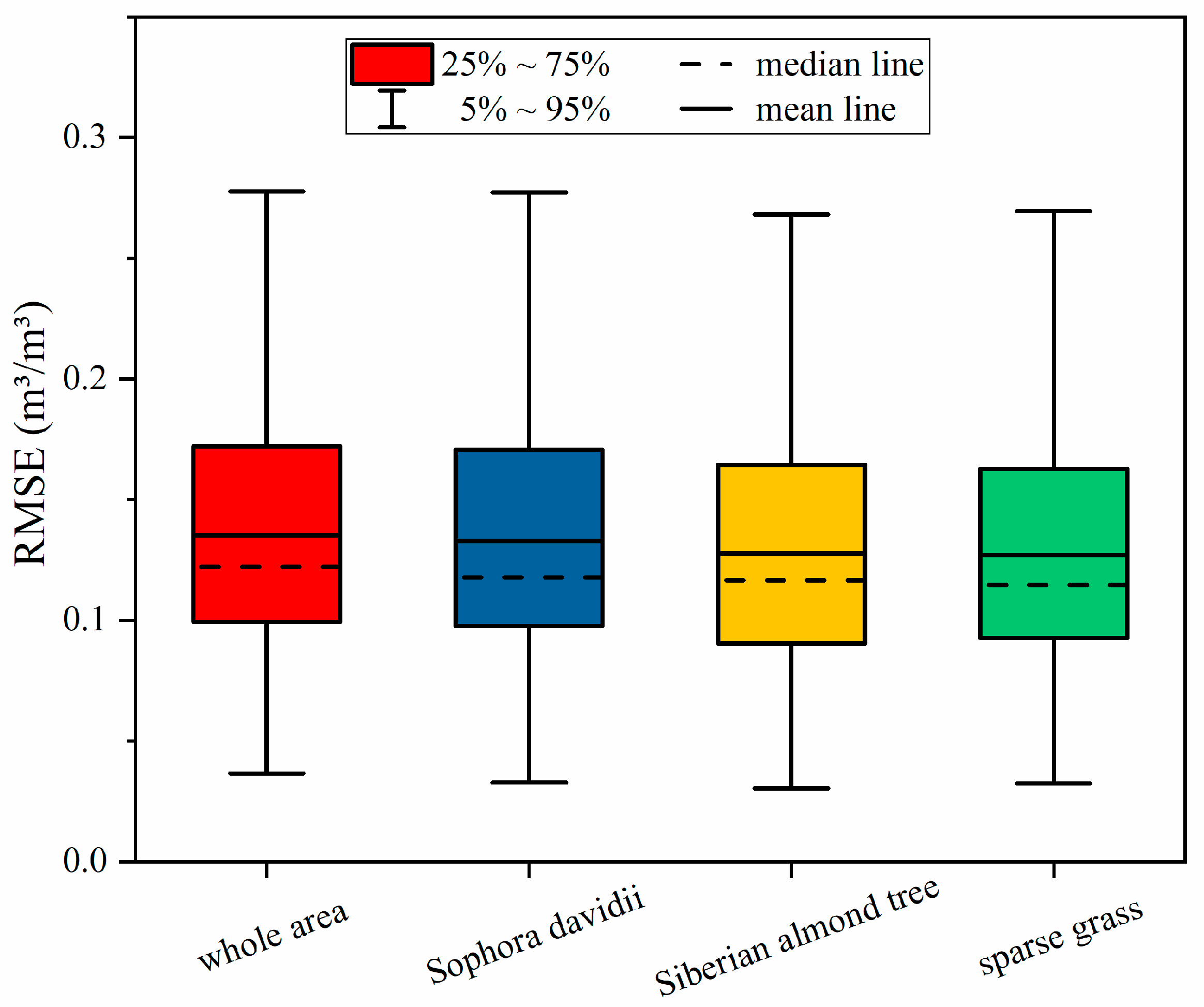
5.3. The Effect of Vegetation Cover on the Downscaling of SM
5.4. Comparison of Downscaled SM Derived from 1-Km and 3-Km SPL2SMAP_S SM Products
5.5. Comparison of Downscaled SM based on SM-RDNet and RF Model
5.6. Analysis of Error Sources in Downscaling SM
6. Conclusions
- (1)
- The 3 km SPL2SMAP_S SM product is a more reliable data source for SM downscaling, since its spatial scale matches better with the original observations of satellites. The RSME of the downscaled SM is 0.0366 m3/m3.
- (2)
- The combination of NDVI, DEM, slope and reflectances as auxiliary data obtains the highest downscaling accuracy due to the adequate information they contain.
- (3)
- The SM-RDNet performs better than the RF model, especially for mining areas with complex human activities. In addition, the downscaled SMs are better under a single vegetation cover, especially grassland.
Author Contributions
Funding
Institutional Review Board Statement
Informed Consent Statement
Data Availability Statement
Acknowledgments
Conflicts of Interest
References
- Saini, V.; Gupta, R.P.; Arora, M.K. Environmental impact studies in coalfields in India: A case study from Jharia coal-field. Renew. Sustain. Energy Rev. 2016, 53, 1222–1239. [Google Scholar] [CrossRef]
- Hasanuzzaman; Bhar, C.; Srivastava, V. Environmental capability: A Bradley–Terry model-based approach to examine the driving factors for sustainable coal-mining environment. Clean Technol. Environ. Policy 2018, 20, 995–1016. [Google Scholar] [CrossRef]
- Li, J.; Pei, Y.; Zhao, S.; Xiao, R.; Sang, X.; Zhang, C. A Review of Remote Sensing for Environmental Monitoring in China. Remote Sens. 2020, 12, 1130. [Google Scholar] [CrossRef] [Green Version]
- Giam, X.; Olden, J.D.; Simberloff, D. Impact of coal mining on stream biodiversity in the US and its regulatory implications. Nat. Sustain. 2018, 1, 176–183. [Google Scholar] [CrossRef]
- Manrique-Alba, À.; Ruiz-Yanetti, S.; Moutahir, H.; Novak, K.; de Luis, M.; Bellot, J. Soil moisture and its role in growth-climate relationships across an aridity gradient in semiarid Pinus halepensis forests. Sci. Total Environ. 2017, 574, 982–990. [Google Scholar] [CrossRef]
- Huang, Z.; Miao, H.-T.; Liu, Y.; Tian, F.-P.; He, H.; Shen, W.; López-Vicente, M.; Wu, G.-L. Soil water content and temporal stability in an arid area with natural and planted grasslands. Hydrol. Process. 2018, 32, 3784–3792. [Google Scholar] [CrossRef] [Green Version]
- Yang, M.J.; Wang, G.L.; Lazin, R.Y.; Shen, X.; Anagnostou, E. Impact of planting time soil moisture on cereal crop yield in the Upper Blue Nile Basin: A novel insight towards agricultural water management. Agric. Water Manag. 2021, 243, 106430. [Google Scholar] [CrossRef]
- Entekhabi, D.; Rodriguez-Iturbe, I.; Castelli, F. Mutual interaction of soil moisture state and atmospheric processes. J. Hydrol. 1996, 184, 3–17. [Google Scholar] [CrossRef]
- Seneviratne, S.I.; Corti, T.; Davin, E.L.; Hirschi, M.; Jaeger, E.B.; Lehner, I.; Orlowsky, B.; Teuling, A.J. Investigating soil moisture—Climate interactions in a changing climate: A review. Earth-Sci. Rev. 2010, 99, 125–161. [Google Scholar] [CrossRef]
- Sabaghy, S.; Walker, J.P.; Renzullo, L.J.; Jackson, T.J. Spatially enhanced passive microwave derived soil moisture: Capabilities and opportunities. Remote Sens. Environ. 2018, 209, 551–580. [Google Scholar] [CrossRef]
- Abowarda, A.S.; Bai, L.; Zhang, C.; Long, D.; Li, X.; Huang, Q.; Sun, Z. Generating surface soil moisture at 30 m spatial resolution using both data fusion and machine learning toward better water resources management at the field scale. Remote Sens. Environ. 2021, 255, 112301. [Google Scholar] [CrossRef]
- Zhang, C.Y.; Li, J.; Lei, S.G.; Yang, J.Z.; Yang, N. Progress and Prospect of the Quantitative Remote Sensing for Monitoring the Eco-environment in Mining Area. Met. Mine 2022, 3, 1–27. [Google Scholar]
- Friedl, M.A.; Davis, F.W. Sources of variation in radiometric surface temperature over a tallgrass prairie. Remote Sens. Environ. 1994, 48, 1–17. [Google Scholar] [CrossRef]
- Anderson, M.C.; Norman, J.M.; Mecikalski, J.R.; Otkin, J.A.; Kustas, W.P. A climatological study of evapotranspiration and moisture stress across the continental United States based on thermal remote sensing: 1. Model formulation. J. Geophys. Res. Earth Surf. 2007, 112, D10117. [Google Scholar] [CrossRef]
- Babaeian, E.; Sadeghi, M.; Franz, T.E.; Jones, S.; Tuller, M. Mapping soil moisture with the OPtical TRApezoid Model (OPTRAM) based on long-term MODIS observations. Remote Sens. Environ. 2018, 211, 425–440. [Google Scholar] [CrossRef]
- Entekhabi, D.; Njoku, E.G.; O’Neill, P.E.; Kellogg, K.H.; Crow, W.T.; Edelstein, W.N.; Entin, J.K.; Goodman, S.D.; Jackson, T.J.; Johnson, J.; et al. The Soil Moisture Active Passive (SMAP) Mission. Proc. IEEE 2010, 98, 704–716. [Google Scholar] [CrossRef]
- Wigneron, J.-P.; Li, X.; Frappart, F.; Fan, L.; Al-Yaari, A.; De Lannoy, G.; Liu, X.; Wang, M.; Le Masson, E.; Moisy, C. SMOS-IC data record of soil moisture and L-VOD: Historical development, applications and perspectives. Remote Sens. Environ. 2021, 254, 112238. [Google Scholar] [CrossRef]
- Ulaby, F.T.; Batlivala, P.P.; Dobson, M.C. Microwave Backscatter Dependence on Surface Roughness, Soil Moisture, and Soil Texture: Part I-Bare Soil. IEEE Trans. Geosci. Electron. 1978, 16, 286–295. [Google Scholar] [CrossRef]
- Ulaby, F.T.; Bradley, G.A.; Dobson, M.C. Microwave Backscatter Dependence on Surface Roughness, Soil Moisture, and Soil Texture: Part II-Vegetation-Covered Soil. IEEE Trans. Geosci. Electron. 1979, 17, 33–40. [Google Scholar] [CrossRef]
- Zribi, M.; Baghdadi, N.; Holah, N.; Fafin, O. New methodology for soil surface moisture estimation and its application to ENVISAT-ASAR multi-incidence data inversion. Remote Sens. Environ. 2005, 96, 485–496. [Google Scholar] [CrossRef]
- Zribi, M.; Andre, C.; Decharme, B. A Method for Soil Moisture Estimation in Western Africa Based on the ERS Scatterometer. IEEE Trans. Geosci. Remote Sens. 2008, 46, 438–448. [Google Scholar] [CrossRef]
- Njoku, E.G.; Jackson, T.J.; Lakshmi, V.; Chan, T.K.; Nghiem, S.J. Soil moisture retrieval from AMSR-E. IEEE Trans. Geosci. Remote Sens. 2003, 41, 215–229. [Google Scholar] [CrossRef]
- Geruo, A.; Velicogna, I.; Kimball, J.S.; Du, J.; Kim, Y.; Colliander, A.; Njoku, E. Satellite-observed changes in vegetation sensitivities to surface soil moisture and total water storage variations since the 2011 Texas drought. Environ. Res. Lett. 2017, 12, 054006. [Google Scholar] [CrossRef] [Green Version]
- Kerr, Y.H.; Waldteufel, P.; Richaume, P.; Wigneron, J.-P.; Ferrazzoli, P.; Mahmoodi, A.; Al Bitar, A.; Cabot, F.; Gruhier, C.; Juglea, S.E.; et al. The SMOS Soil Moisture Retrieval Algorithm. IEEE Trans. Geosci. Remote Sens. 2012, 50, 1384–1403. [Google Scholar] [CrossRef]
- Colliander, A.; Jackson, T.J.; Bindlish, R.; Chan, S.; Das, N.; Kim, S.B.; Cosh, M.H.; Dunbar, R.S.; Dang, L.; Pashaian, L.; et al. Validation of SMAP surface soil moisture products with core validation sites. Remote Sens. Environ. 2017, 191, 215–231. [Google Scholar] [CrossRef]
- Sabaghy, S.; Walker, J.P.; Renzullo, L.J.; Akbar, R.; Chan, S.; Chaubell, J.; Das, N.; Dunbar, R.S.; Entekhabi, D.; Gevaert, A.; et al. Comprehensive analysis of alternative downscaled soil moisture products. Remote Sens. Environ. 2020, 239, 111586. [Google Scholar] [CrossRef]
- Peng, J.; Loew, A.; Merlin, O.; Verhoest, N.E.C. A review of spatial downscaling of satellite remotely sensed soil moisture. Rev. Geophys. 2017, 55, 341–366. [Google Scholar] [CrossRef]
- Merlin, O.; Al Bitar, A.; Walker, J.; Kerr, Y. An improved algorithm for disaggregating microwave-derived soil moisture based on red, near-infrared and thermal-infrared data. Remote Sens. Environ. 2010, 114, 2305–2316. [Google Scholar] [CrossRef] [Green Version]
- Kim, J.; Hogue, T.S. Improving Spatial Soil Moisture Representation Through Integration of AMSR-E and MODIS Products. IEEE Trans. Geosci. Remote Sens. 2012, 50, 446–460. [Google Scholar] [CrossRef]
- Fang, B.; Lakshmi, V.; Bindlish, R.; Jackson, T.J. Downscaling of SMAP Soil Moisture Using Land Surface Temperature and Vegetation Data. Vadose Zone J. 2018, 17, 170198. [Google Scholar] [CrossRef] [Green Version]
- Merlin, O.; Escorihuela, M.J.; Mayoral, M.A.; Hagolle, O.; Al Bitar, A.; Kerr, Y. Self-calibrated evaporation-based disaggregation of SMOS soil moisture: An evaluation study at 3 km and 100 m resolution in Catalunya, Spain. Remote Sens. Environ. 2013, 130, 25–38. [Google Scholar] [CrossRef] [Green Version]
- Merlin, O.; Malbéteau, Y.; Notfi, Y.; Bacon, S.; Khabba, S.E.-R.S.; Jarlan, L. Performance Metrics for Soil Moisture Downscaling Methods: Application to DISPATCH Data in Central Morocco. Remote Sens. 2015, 7, 3783–3807. [Google Scholar] [CrossRef] [Green Version]
- Tian, J.; Deng, X.; Su, H. Intercomparison of two trapezoid-based soil moisture downscaling methods using three scaling factors. Int. J. Digit. Earth 2019, 12, 485–499. [Google Scholar] [CrossRef]
- Das, N.N.; Entekhabi, D.; Dunbar, R.S.; Chaubell, M.J.; Colliander, A.; Yueh, S.; Jagdhuber, T.; Chen, F.; Crow, W.; O’Neill, P.E.; et al. The SMAP and Copernicus Sentinel 1A/B microwave active-passive high resolution surface soil moisture product. Remote Sens. Environ. 2019, 233, 111380. [Google Scholar] [CrossRef]
- Das, N.; Entekhabi, D.; Dunbar, R.S.; Kim, S.; Yueh, S.; Colliander, A.; O’Neill, P.E.; Jackson, T.; Jagdhuber, T.; Chen, F.; et al. SMAP/Sentinel-1 L2 Radiometer/Radar 30-Second Scene 3-km EASE-Grid Soil Moisture, Version 3; NASA National Snow and Ice Data Center Distributed Active Archive Center: Boulder, CO, USA, 2020. [Google Scholar] [CrossRef]
- Zhan, X.W.; Houser, P.R.; Walker, J.P.; Crow, W.T. A method for retrieving high-resolution surface soil moisture from hydros L-band radiometer and Radar observations. IEEE Trans. Geosci. Remote Sens. 2006, 44, 1534–1544. [Google Scholar] [CrossRef]
- Wu, X.; Walker, J.P.; Rudiger, C.; Panciera, R.; Gao, Y. Medium-Resolution Soil Moisture Retrieval Using the Bayesian Merging Method. IEEE Trans. Geosci. Remote Sens. 2017, 55, 6482–6493. [Google Scholar] [CrossRef]
- Piles, M.; Entekhabi, D.; Camps, A. A Change Detection Algorithm for Retrieving High-Resolution Soil Moisture from SMAP Radar and Radiometer Observations. IEEE Trans. Geosci. Remote Sens. 2009, 47, 4125–4131. [Google Scholar] [CrossRef]
- Das, N.N.; Entekhabi, D.; Njoku, E.G. An Algorithm for Merging SMAP Radiometer and Radar Data for High-Resolution Soil-Moisture Retrieval. IEEE Trans. Geosci. Remote Sens. 2011, 49, 1504–1512. [Google Scholar] [CrossRef]
- Das, N.N.; Entekhabi, D.; Njoku, E.G.; Shi, J.J.C.; Johnson, J.T.; Colliander, A. Tests of the SMAP Combined Radar and Radiometer Algorithm Using Airborne Field Campaign Observations and Simulated Data. IEEE Trans. Geosci. Remote Sens. 2014, 52, 2018–2028. [Google Scholar] [CrossRef]
- Akbar, R.; Moghaddam, M. A Combined Active–Passive Soil Moisture Estimation Algorithm with Adaptive Regularization in Support of SMAP. IEEE Trans. Geosci. Remote Sens. 2015, 53, 3312–3324. [Google Scholar] [CrossRef]
- Wilson, D.J.; Western, A.W.; Grayson, R.B. A terrain and data-based method for generating the spatial distribution of soil moisture. Adv. Water Resour. 2005, 28, 43–54. [Google Scholar] [CrossRef]
- Yan, R.; Bai, J. A New Approach for Soil Moisture Downscaling in the Presence of Seasonal Difference. Remote Sens. 2020, 12, 2818. [Google Scholar] [CrossRef]
- Kim, G.; Barros, A.P. Space–time characterization of soil moisture from passive microwave remotely sensed imagery and ancillary data. Remote Sens. Environ. 2002, 81, 393–403. [Google Scholar] [CrossRef]
- Vereecken, H.; Huisman, J.A.; Bogena, H.; Vanderborght, J.; Vrugt, J.A.; Hopmans, J. On the value of soil moisture measurements in vadose zone hydrology: A review. Water Resour. Res. 2008, 44, W00D06. [Google Scholar] [CrossRef] [Green Version]
- Crow, W.T.; Berg, A.A.; Cosh, M.H.; Loew, A.; Mohanty, B.P.; Panciera, R.; de Rosnay, P.; Ryu, D.; Walker, J.P. Upscaling sparse ground-based soil moisture observations for the validation of coarse-resolution satellite soil moisture products. Rev. Geophys. 2012, 50, RG2002. [Google Scholar] [CrossRef] [Green Version]
- Cowley, G.S.; Niemann, J.D.; Green, T.R.; Seyfried, M.S.; Jones, A.S.; Grazaitis, P.J. Impacts of precipitation and potential evapotranspiration patterns on downscaling soil moisture in regions with large topographic relief. Water Resour. Res. 2017, 53, 1553–1574. [Google Scholar] [CrossRef]
- Yan, H.B.; Zhou, G.Q.; Yang, F.F.; Lu, X.J. DEM correction to the TVDI method on drought monitoring in karst areas. Int. J. Remote Sens. 2019, 40, 2166–2189. [Google Scholar] [CrossRef]
- El Hajj, M.; Baghdadi, N.; Zribi, M.; Bazzi, H. Synergic Use of Sentinel-1 and Sentinel-2 Images for Operational Soil Moisture Mapping at High Spatial Resolution Over Agricultural Areas. Remote Sens. 2017, 9, 1292. [Google Scholar] [CrossRef] [Green Version]
- Deshon, J.P.; Niemann, J.D.; Green, T.R.; Jones, A.; Grazaitis, P.J. Stochastic analysis and probabilistic downscaling of soil moisture in small catchments. J. Hydrol. 2020, 585, 124711. [Google Scholar] [CrossRef]
- Babaeian, E.; Sadeghi, M.; Jones, S.B.; Montzka, C.; Vereecken, H.; Tuller, M. Ground, Proximal, and Satellite Remote Sensing of Soil Moisture. Rev. Geophys. 2019, 57, 530–616. [Google Scholar] [CrossRef] [Green Version]
- Shi, H.; Fu, X.; Chen, J.; Wang, G.; Li, T. Spatial distribution of monthly potential evaporation over mountainous regions: Case of the Lhasa River basin, China. Hydrol. Sci. J. 2014, 59, 1856–1871. [Google Scholar] [CrossRef]
- Ranney, K.J.; Niemann, J.D.; Lehman, B.M.; Green, T.R.; Jones, A.S. A method to downscale soil moisture to fine resolutions using topographic, vegetation, and soil data. Adv. Water Resour. 2015, 76, 81–96. [Google Scholar] [CrossRef] [Green Version]
- Chai, S.-S.; Walker, J.P.; Makarynskyy, O.; Kuhn, M.; Veenendaal, B.; West, G. Use of Soil Moisture Variability in Artificial Neural Network Retrieval of Soil Moisture. Remote Sens. 2009, 2, 166–190. [Google Scholar] [CrossRef] [Green Version]
- Zhao, W.; Sanchez, N.; Lu, H.; Li, A. A spatial downscaling approach for the SMAP passive surface soil moisture product using random forest regression. J. Hydrol. 2018, 563, 1009–1024. [Google Scholar] [CrossRef]
- Wei, Z.S.; Meng, Y.Z.; Zhang, W.; Peng, J.; Meng, L.K. Downscaling SMAP soil moisture estimation with gradient boosting decision tree regression over the Tibetan Plateau. Remote Sens. Environ. 2019, 225, 30–44. [Google Scholar] [CrossRef]
- Yuan, Q.; Shen, H.F.; Li, T.W.; Li, Z.W.; Li, S.W.; Jiang, Y.; Xu, H.Z.; Tan, W.W.; Yang, Q.W.; Wang, J.; et al. Deep learning in environmental remote sensing: Achievements and challenges. Remote Sens. Environ. 2020, 241, 111716. [Google Scholar] [CrossRef]
- Senanayake, I.P.; Yeo, I.-Y.; Walker, J.P.; Willgoose, G.R. Estimating catchment scale soil moisture at a high spatial resolution: Integrating remote sensing and machine learning. Sci. Total Environ. 2021, 776, 145924. [Google Scholar] [CrossRef]
- Liu, Y.; Jing, W.; Wang, Q.; Xia, X. Generating high-resolution daily soil moisture by using spatial downscaling techniques: A comparison of six machine learning algorithms. Adv. Water Resour. 2020, 141, 103601. [Google Scholar] [CrossRef]
- LeCun, Y.; Bengio, Y.; Hinton, G. Deep learning. Nature 2015, 521, 436–444. [Google Scholar] [CrossRef]
- Xu, W.; Zhang, Z.; Long, Z.; Qin, Q. Downscaling SMAP Soil Moisture Products with Convolutional Neural Network. IEEE J. Sel. Top. Appl. Earth Obs. Remote Sens. 2021, 14, 4051–4062. [Google Scholar] [CrossRef]
- Bai, L.; Long, D.; Yan, L. Estimation of Surface Soil Moisture with Downscaled Land Surface Temperatures Using a Data Fusion Approach for Heterogeneous Agricultural Land. Water Resour. Res. 2019, 55, 1105–1128. [Google Scholar] [CrossRef]
- Vergopolan, N.; Chaney, N.W.; Beck, H.E.; Pan, M.; Sheffield, J.; Chan, S.; Wood, E.F. Combining hyper-resolution land surface modeling with SMAP brightness temperatures to obtain 30-m soil moisture estimates. Remote Sens. Environ. 2020, 242, 111740. [Google Scholar] [CrossRef]
- Zhang, D.S.; Fan, G.W.; Liu, Y.D.; Ma, L.Q. Field trials of aquifer protection in longwall mining of shallow coal seams in China. Int. J. Rock Mech. Min. Sci. 2010, 47, 908–914. [Google Scholar] [CrossRef]
- Xiao, W.; Zhang, W.; Ye, Y.; Lv, X.; Yang, W. Is underground coal mining causing land degradation and significantly damaging ecosystems in semi-arid areas? A study from an Ecological Capital perspective. Land Degrad. Dev. 2020, 31, 1969–1989. [Google Scholar] [CrossRef]
- Li, J.; Peng, S.; Zhang, C.; Yang, F.; Sang, X. Quantitative remote sensing-based monitoring and evaluation of the ecological environment in mining areas: Technology framework and application. J. Min. Sci. Technol. 2022, 7, 9–25. [Google Scholar] [CrossRef]
- Rogers, D.J.; Randolph, S.E. Mortality rates and population density of tsetse flies correlated with satellite imagery. Nature 1991, 351, 739–741. [Google Scholar] [CrossRef]
- Zhang, Y.; Tian, Y.; Kong, Y.; Zhong, B.; Fu, Y. Residual Dense Network for Image Super-Resolution. In Proceedings of the 2018 IEEE/CVF Conference on Computer Vision and Pattern Recognition, Salt Lake City, UT, USA, 18–23 June 2018; pp. 2472–2481. [Google Scholar] [CrossRef] [Green Version]
- Gruber, A.; De Lannoy, G.; Albergel, C.; Al-Yaari, A.; Brocca, L.; Calvet, J.-C.; Colliander, A.; Cosh, M.; Crow, W.; Dorigo, W.; et al. Validation practices for satellite soil moisture retrievals: What are (the) errors? Remote Sens. Environ. 2020, 244, 111806. [Google Scholar] [CrossRef]
- Liu, Y.; Yue, H. Remote Sensing Monitoring of Soil Moisture in the Daliuta Coal Mine Based on SPOT 5/6 and Worldview-2. Open Geosci. 2019, 11, 866–876. [Google Scholar] [CrossRef]
- Bahrami, S.; Ardejani, F.D.; Baafi, E. Application of artificial neural network coupled with genetic algorithm and simulated annealing to solve groundwater inflow problem to an advancing open pit mine. J. Hydrol. 2016, 536, 471–484. [Google Scholar] [CrossRef] [Green Version]
- Sadeghi, M.; Babaeian, E.; Tuller, M.; Jones, S.B. The optical trapezoid model: A novel approach to remote sensing of soil moisture applied to Sentinel-2 and Landsat-8 observations. Remote Sens. Environ. 2017, 198, 52–68. [Google Scholar] [CrossRef] [Green Version]
- Yee, M.S.; Walker, J.P.; Monerris, A.; Rüdiger, C.; Jackson, T.J. On the identification of representative in situ soil moisture monitoring stations for the validation of SMAP soil moisture products in Australia. J. Hydrol. 2016, 537, 367–381. [Google Scholar] [CrossRef]
- van der Velde, R.; Salama, M.S.; van Helvoirt, M.D.; Su, Z.; Ma, Y. Decomposition of Uncertainties between Coarse MM5–Noah-Simulated and Fine ASAR-Retrieved Soil Moisture over Central Tibet. J. Hydrometeorol. 2012, 13, 1925–1938. [Google Scholar] [CrossRef]
- Long, D.; Bai, L.L.; Yan, L.; Zhang, C.J.; Yang, W.T.; Lei, H.M.; Quan, J.L.; Meng, X.Y.; Shi, C.X. Generation of spatially complete and daily continuous surface soil moisture of high spatial resolution. Remote Sens. Environ. 2019, 233, 111364. [Google Scholar] [CrossRef]
- Peng, J.; Albergel, C.; Balenzano, A.; Brocca, L.; Cartus, O.; Cosh, M.H.; Crow, W.T.; Dabrowska-Zielinska, K.; Dadson, S.; Davidson, M.W.; et al. A roadmap for high-resolution satellite soil moisture applications–confronting product characteristics with user requirements. Remote Sens. Environ. 2020, 252, 112162. [Google Scholar] [CrossRef]


| Band Name | Resolution | Description | Band Name | Resolution | Description |
|---|---|---|---|---|---|
| B2 | 10 m | Blue | B3 | 10 m | Green |
| B4 | 10 m | Red | B5 | 20 m | Red Edge 1 |
| B6 | 20 m | Red Edge 2 | B7 | 20 m | Red Edge 3 |
| B8 | 10 m | NIR | B8A | 20 m | Red Edge 4 |
| B11 | 20 m | SWIR 1 | B12 | 20 m | SWIR 2 |
| Input Data Sets | Whole Area (n 1 = 54) | Sophora Davidii (n 1 = 9) | Siberian Almond Tree (n 1 = 14) | Sparse Grass (n 1 = 13) |
|---|---|---|---|---|
| reflectances | 0.1932 | 0.1911 | 0.1860 | 0.1841 |
| reflectances + NDVI | 0.0944 | 0.0912 | 0.0867 | 0.0882 |
| reflectances + DEM | 0.1121 | 0.1105 | 0.1043 | 0.1063 |
| reflectances + slope | 0.1207 | 0.1156 | 0.1152 | 0.1139 |
| reflectances + NDVI + DEM | 0.1236 | 0.1201 | 0.1179 | 0.1153 |
| reflectances + NDVI + slope | 0.1341 | 0.1324 | 0.1271 | 0.1255 |
| reflectances + NDVI + slope | 0.1281 | 0.1250 | 0.1229 | 0.1195 |
| reflectances + NDVI + DEM + slope | 0.1065 | 0.1040 | 0.0995 | 0.0979 |
| Input Data Sets | Whole Area (n 1 = 54) | Sophora Davidii (n 1 = 9) | Siberian Almond Tree (n 1 = 14) | Sparse Grass (n 1 = 13) |
|---|---|---|---|---|
| reflectances | 0.1510 | 0.1504 | 0.1426 | 0.1416 |
| reflectances + NDVI | 0.0509 | 0.0483 | 0.0437 | 0.0396 |
| reflectances + DEM | 0.0774 | 0.0761 | 0.0676 | 0.0675 |
| reflectances + slope | 0.1046 | 0.1053 | 0.0943 | 0.0969 |
| reflectances + NDVI + DEM | 0.2776 | 0.2772 | 0.2681 | 0.2696 |
| reflectances + NDVI + slope | 0.2189 | 0.2158 | 0.2115 | 0.2101 |
| reflectances + DEM + slope | 0.2331 | 0.2307 | 0.2263 | 0.2238 |
| reflectances + NDVI + DEM + slope | 0.0366 | 0.0328 | 0.0305 | 0.0324 |
Publisher’s Note: MDPI stays neutral with regard to jurisdictional claims in published maps and institutional affiliations. |
© 2022 by the authors. Licensee MDPI, Basel, Switzerland. This article is an open access article distributed under the terms and conditions of the Creative Commons Attribution (CC BY) license (https://creativecommons.org/licenses/by/4.0/).
Share and Cite
Sang, X.; Li, J.; Zhang, C.; Xing, J.; Liu, X.; Wang, H.; Zhang, C. Downscaling Microwave Soil Moisture Products with SM-RDNet for Semiarid Mining Areas. Water 2022, 14, 1792. https://doi.org/10.3390/w14111792
Sang X, Li J, Zhang C, Xing J, Liu X, Wang H, Zhang C. Downscaling Microwave Soil Moisture Products with SM-RDNet for Semiarid Mining Areas. Water. 2022; 14(11):1792. https://doi.org/10.3390/w14111792
Chicago/Turabian StyleSang, Xiao, Jun Li, Chengye Zhang, Jianghe Xing, Xinhua Liu, Hongpeng Wang, and Caiyue Zhang. 2022. "Downscaling Microwave Soil Moisture Products with SM-RDNet for Semiarid Mining Areas" Water 14, no. 11: 1792. https://doi.org/10.3390/w14111792
APA StyleSang, X., Li, J., Zhang, C., Xing, J., Liu, X., Wang, H., & Zhang, C. (2022). Downscaling Microwave Soil Moisture Products with SM-RDNet for Semiarid Mining Areas. Water, 14(11), 1792. https://doi.org/10.3390/w14111792