
Monitoring of Land Desertification Changes in Urat Front Banner from 2010 to 2020 Based on Remote Sensing Data


Abstract
:1. Introduction
2. Materials and Methods
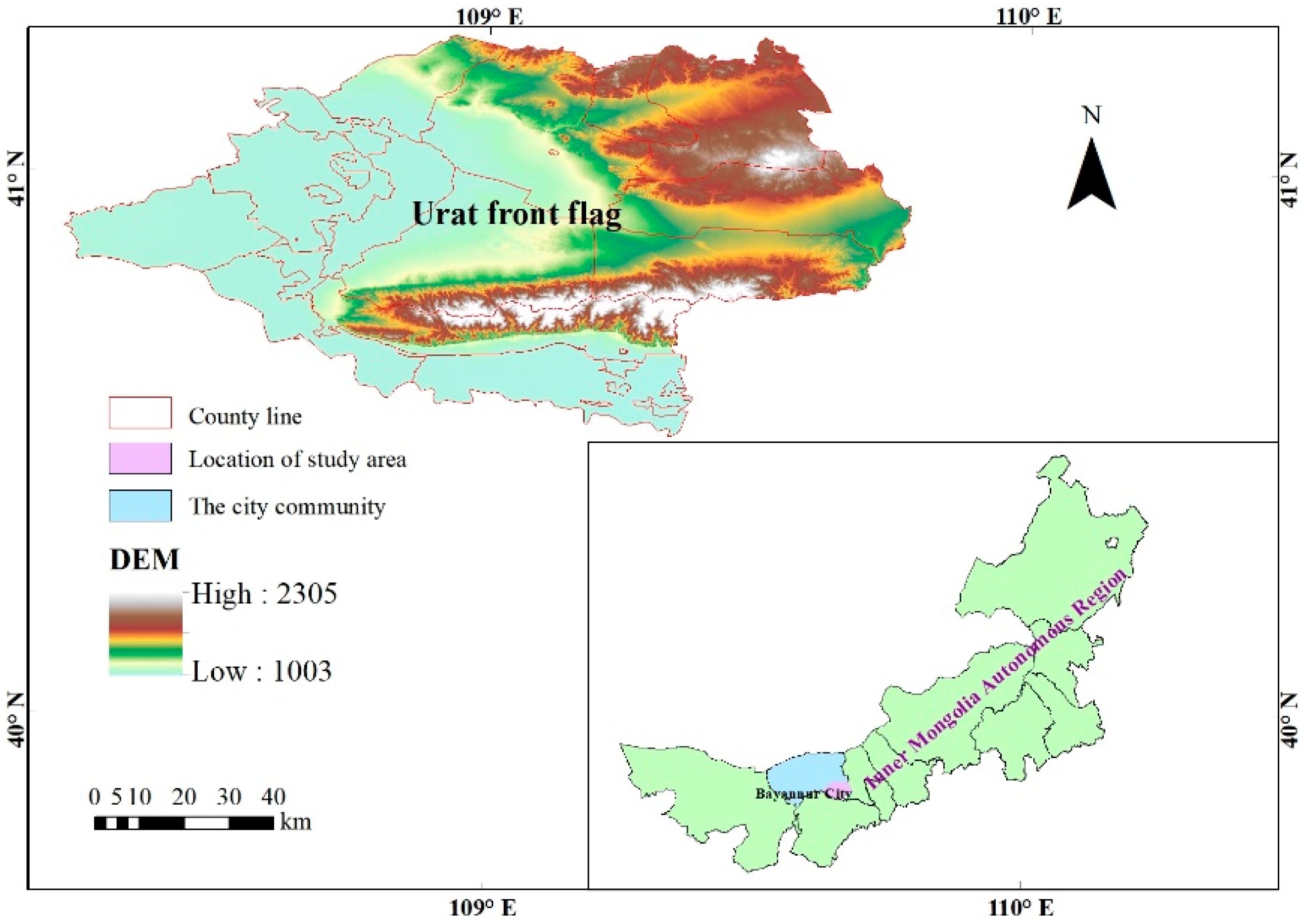
2.1. Overview of the Study Area
2.2. Data Source and Its Pre-Processing
2.3. Research Method and Process
2.3.1. Normalized Difference Vegetation Index (NDVI)
2.3.2. Land Surface Albedo
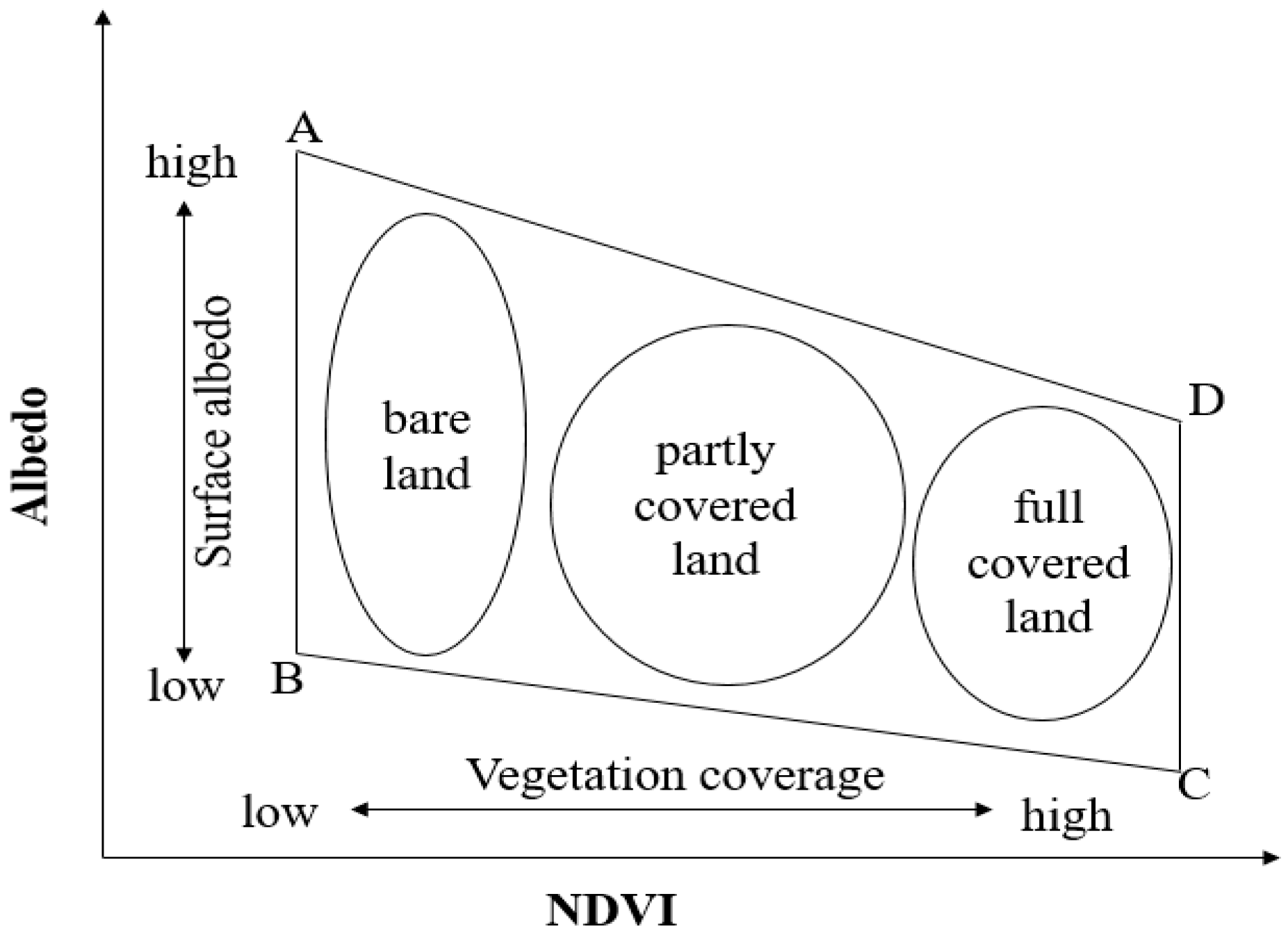
2.3.3. Albedo–NDVI Feature Space Analysis
2.3.4. Desertification Difference Index (DDI)
2.3.5. Accuracy Verification of Desertification Classification
2.3.6. Desertification Land Transfer Matrix Model
2.3.7. Dynamic Change Model of Desertification Land
2.3.8. Center of Gravity Migration Model of Desertification Land
2.3.9. CASA Model
3. Results and Analysis
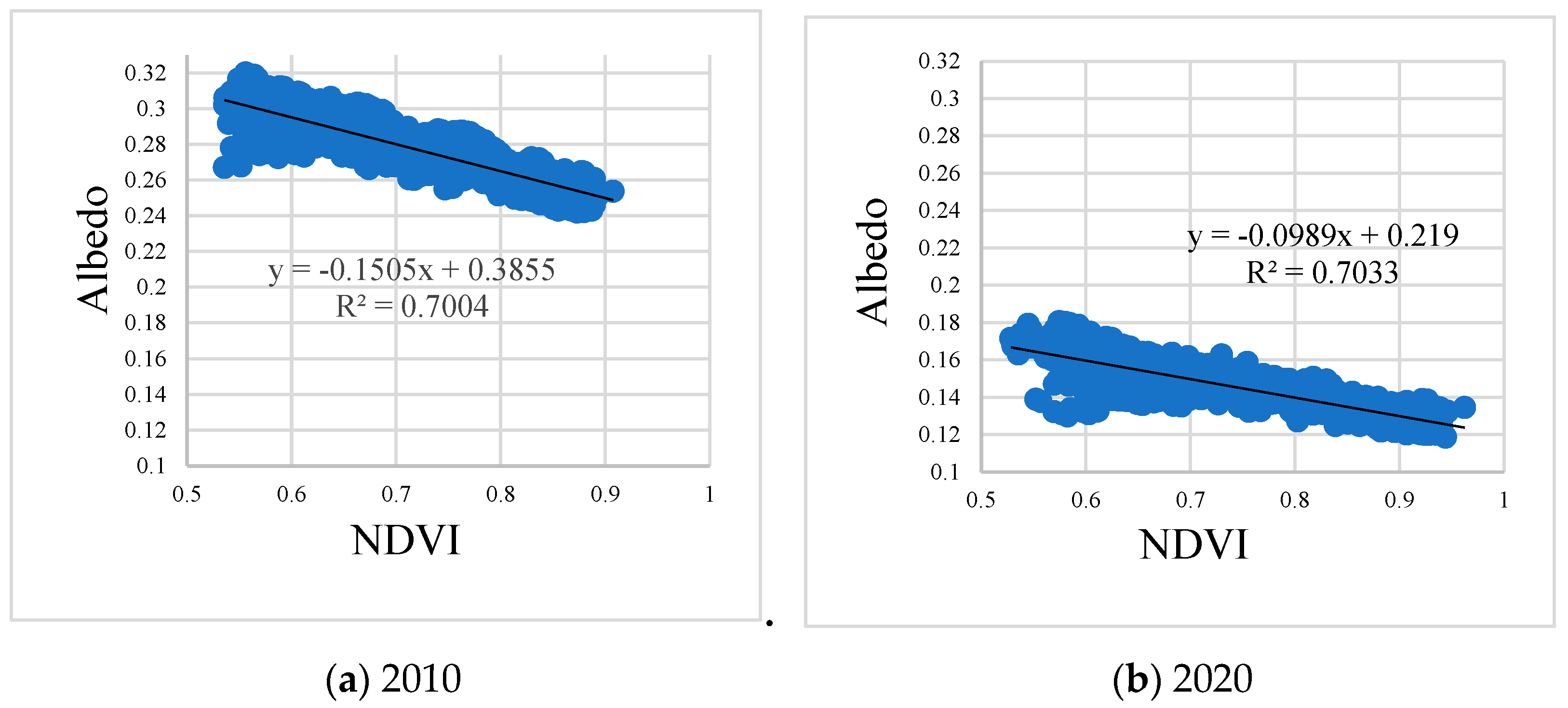
3.1. Albedo–NDVI Feature Space Analysis
3.2. DDI Analysis
3.3. Accuracy Validation
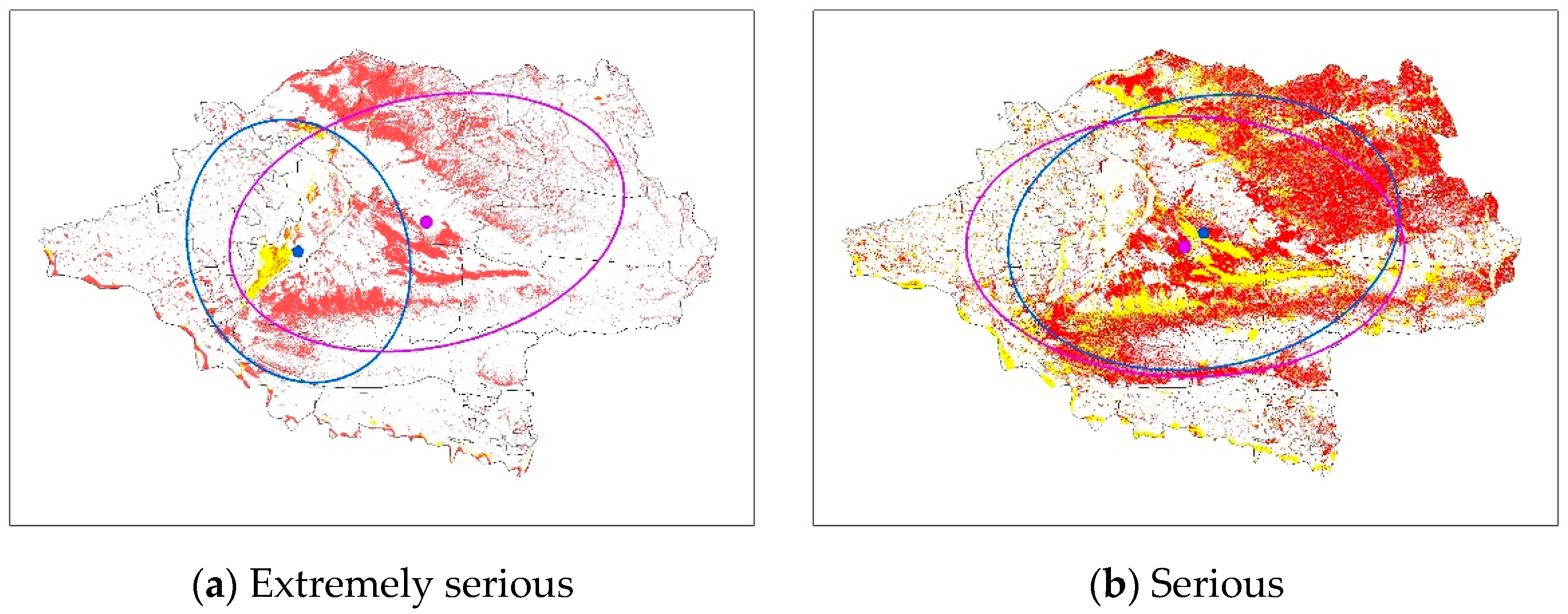
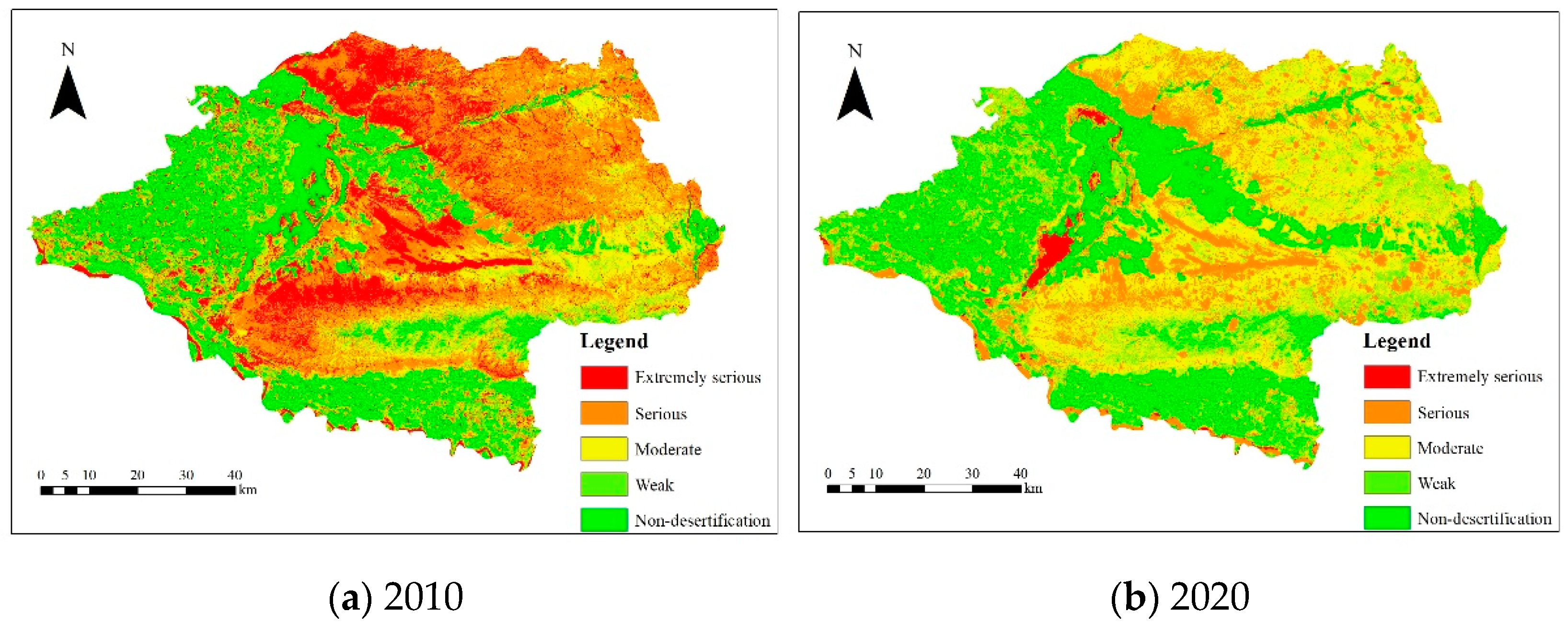
3.4. Spatial Distribution Characteristics of Desertification Land
3.5. Characteristics of Desertification Land Area Change
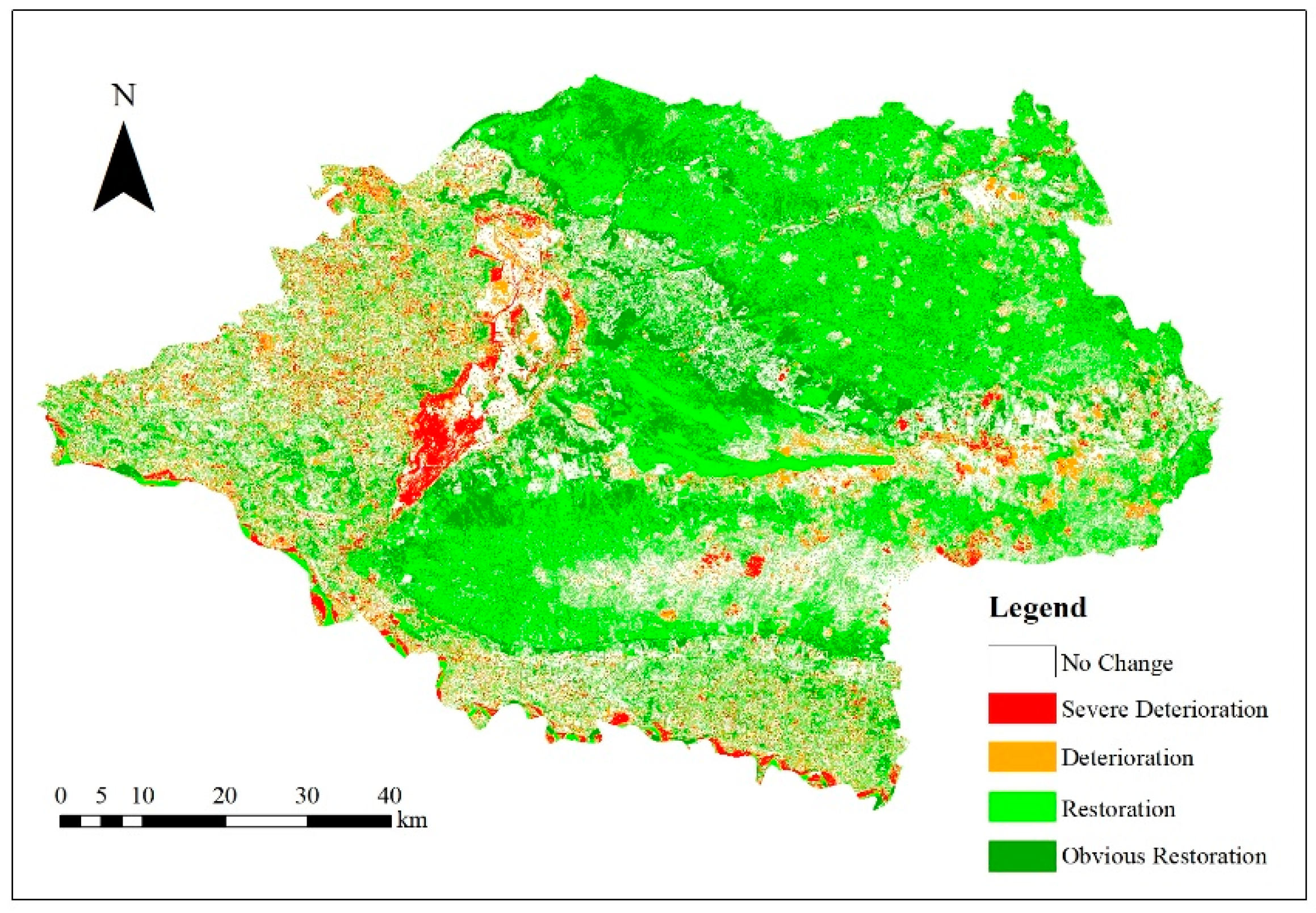
3.6. Characteristics of Desertification Land Transfer Change
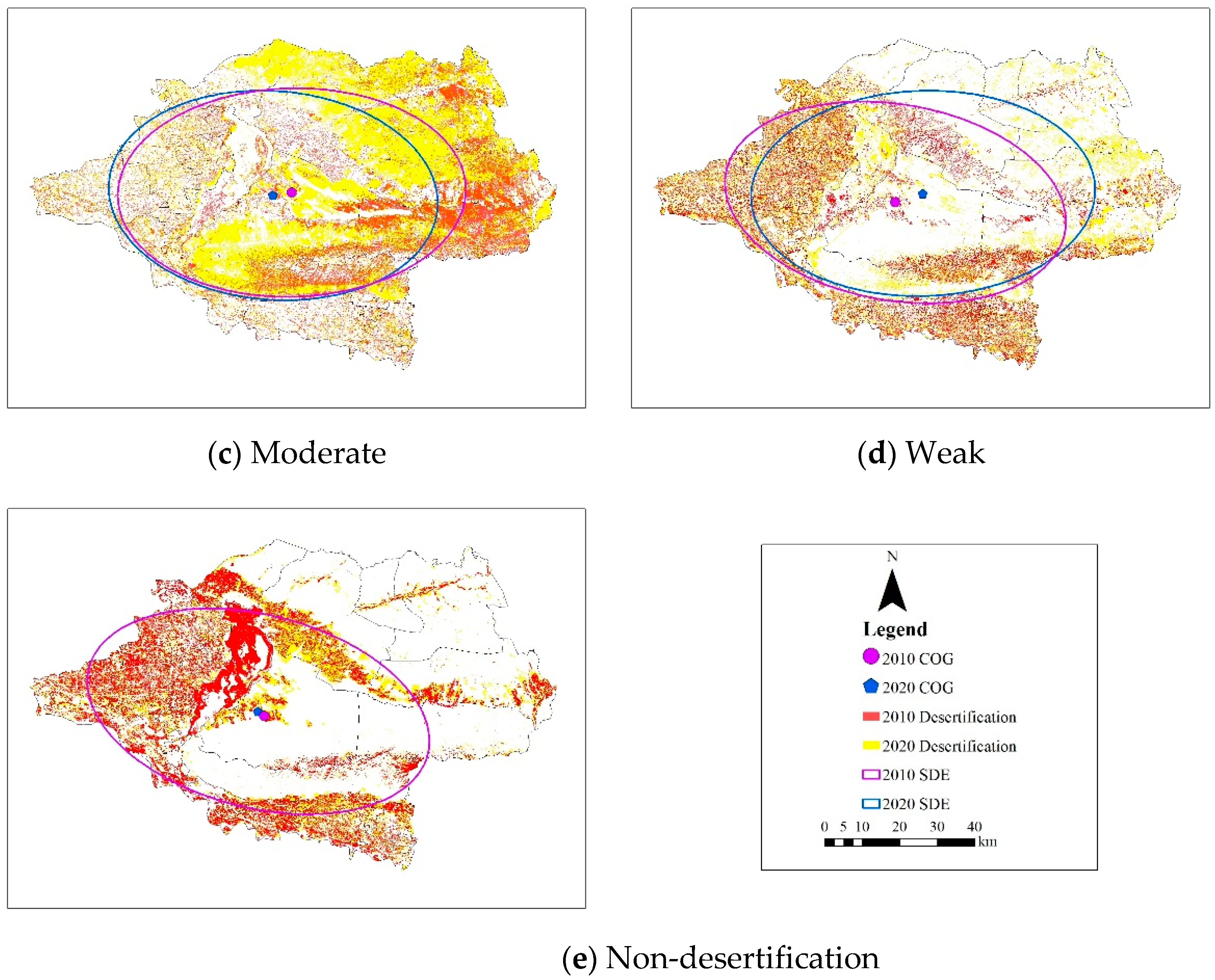
3.7. Spatial Pattern Variation of Desertification Land
4. Discussion
5. Conclusions
- (1)
- The overall desertification status in the Urat front flag has improved, and the desertification land area for each grade has been altered to different degrees.
- (2)
- Between 2010 and 2020, the desertification recovery area in the study area is primarily driven by the conversion of extremely serious to moderate, serious to non-desertification, and moderate desertification to non-desertification, whereas the desertification aggravation area is primarily driven by the conversion of serious desertification to moderate desertification.
- (3)
- In descending order, the conversion rate of each type of desertification land area is as follows: extremely serious desertification > moderate desertification > weak desertification > serious desertification > non-desertification.
- (4)
- The study area is arid with little rainfall and a water scarcity as a consequence of its geographic location and climatic environment, and the degree of desertification in the region is dominated by serious, weak, and non-desertification land types.
- (5)
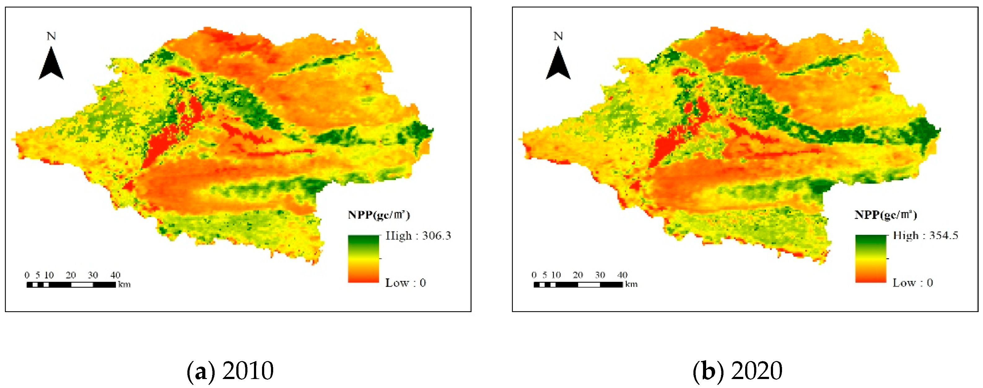
- The dynamic change of vegetation NPP is the consequence of the combined effects of climate change and human activities. Annual NPP per unit area in Urat front flag reached 306.3 gC/m2 in 2010 and 354.5 gC/m2 in 2020, a rise of 48.2 gC/m2 each year since 2010, and the overall distribution is growing in a band from west to east.
Author Contributions
Funding
Institutional Review Board Statement
Informed Consent Statement
Data Availability Statement
Conflicts of Interest
References
- Sun, L.; Ou, Y.; Yu, F.; Liang, L. Effect of Film Lined Rice on the Change of Soil Carbon Pool in Repairing Desertification Soil. Soil Sci. 2022, 7, 70–77. [Google Scholar] [CrossRef]
- Cheng, L.; Yin, C.; Lu, Q.; Wu, B.; Que, X. Economic analysis of the causes of desertification and irrational human activities. Chin. J. Agric. Resour. Reg. Plan. 2016, 7, 123–129. [Google Scholar] [CrossRef]
- Yao, Y. Research on the driving force of desertification and soil and water conservation in inner mongolia. Chin. J. Agric. Resour. Reg. Plan. 2018, 6, 13–17. [Google Scholar] [CrossRef]
- Xu, C. Study on Dynamic Change of Desertification in Hulunbeier. Ph.D. Thesis, Jilin University, Changchun, China, 2010. Volume 80. pp. 1–80. [Google Scholar]
- Wang, T. The Aeolian Desertification Dynamics and Related Ecological Environment Effect in the Otindag Sandy Land. Ph.D. Thesis, Beijing Forestry University, Beijing, China, 2020. Volume 68. pp. 1–68. [Google Scholar] [CrossRef]
- Wang, T.; Liu, S. Regionalization for Regulating Oasification and Desertification in the Arid Regions of China: A program. J. Desert Res. 2013, 8, 959–966. [Google Scholar] [CrossRef]
- You, Y.C.; Li, Z.W.; Huang, C.; Zeng, H. Spatial-temporal Evolution Characteristics of Land Desertification in the Zoige Plateau in 1990–2016. J. Ecol. Environ. Sci. 2017, 10, 1671–1680. [Google Scholar] [CrossRef]
- Guo, Q. Monitoring and Assessment of Desertification from Remote Sensing in the Northern China. Ph.D. Thesis, University of Chinese Academy of Sciences, Beijing, China, 2018. Volume 129. pp. 1–129. [Google Scholar]
- Oloukoi, J.; Gbenga, A.-E.; Langyit, D.-G. Desertification risk analysis and assessment in Northern Nigeria. Remote Sens. Appl. Soc. Environ. 2018, 12, 70–82. [Google Scholar] [CrossRef]
- Yao, Z.Y.; Wang, T.; Zhu, K.W. Land Desertification Romote Sensing Monitoring in 2000 in Alashan League Inner Mongolia. J. Arid. Land Resour. Environ. 2008, 5, 47–51. [Google Scholar]
- Jian, W.; Dao, L.-P. The Remote Sensing Dynamic Monitoring of Land Sandy Desertification in Duolun County. In Proceedings of the 2011 Fourth International Conference on Intelligent Computation Technology and Automation, Shenzhen, China, 28–29 March 2011. [Google Scholar] [CrossRef]
- Basso, F.; Bove, E.; Dumontet, S. Evaluating environmental sensitivity at the basin scale through the use of geographic information systems and remotely sensed data: An example covering the Agri basin (Southern Italy). Catena 2000, 16, 19–35. [Google Scholar] [CrossRef]
- Jeong, S.-J.; Ho, C.-H.; Brown, M.-E.; Brown, J.-S.; Kug, S. Browning in desert boundaries in Asia in recent decades. J. Geophys. Res. Appl. Geogr. 2011, 116, D02103. [Google Scholar] [CrossRef] [Green Version]
- Salvati, L.; Bajocco, S. Land sensitivity to desertification across Italy: Past, present, and future. J. Appl. Geogr. 2011, 31, 223–231. [Google Scholar] [CrossRef]
- Wang, F.; Wu, Z.; Wang, Y.; Jiao, W.; Chen, Y. Dynamic monitoring of desertification in the Tarim Basin based on RS and GIS techniques. Chin. J. Ecol. 2017, 9, 1029–1037. [Google Scholar]
- Zhang, J.X.; Zhang, D.Y.; Liu, W.F.; Hu, A.P.; Wang, D.; Hu, J.Q. ESAI Based Assessment of Desertification Risk in Loess Plateau. Bull. Soil Water Conserv. 2017, 7, 339–344, 353. [Google Scholar]
- Xue, Z.J.; Qin, Z.; Cheng, F. Long-term dynamic characterization of aeolian desertification in northwest Shanxi, China. China Environ. Sci. 2020, 8, 17166–17174. [Google Scholar]
- Chen, F.; Liu, H.J.; Liu, S.J.; Ochir, A. MODIS-based Desertification Dynamic Monitoring in Mongolia from 2003–2017. J. Northwest For. Univ. 2019, 5, 167–171. [Google Scholar] [CrossRef]
- Pang, S.N. Remote Sensing Monitoring of Desertification in Yili and Bozhou Region. Ph.D. Thesis, Xinjiang University, Xinjiang, China, 2009. Volume 73. pp. 1–73. [Google Scholar]
- Huo, A.D. Study on Aeolian Desertification Remote Sensing Monitoring System in China Using MODIS Image Data. Ph.D. Thesis, Northwest A&F University, Xianyang, China, 2008. Volume 144. pp. 1–144. [Google Scholar]
- Zhao, Y.Y.; Gao, G.L.; Qin, S.G.; Yu, M.H.; Ding, G.D. Desertification detection and the evaluation indicators: A review. J. Arid. Land Resour. Environ. 2019, 7, 81–87. [Google Scholar]
- Zhou, D.; Zhao, X.; Hu, H.; Shen, H.; Fang, J. Long-term vegetation changes in the four mega-sandy lands in Inner Mongolia, China. Landsc. Ecol. 2015, 13, 1613–1626. [Google Scholar] [CrossRef]
- Sternberg, T.; Tsolmon, R.; Middleton, N.; Thomas, D. Tracking desertification on the Mongolian steppe through NDVI and field-survey data. Int. J. Digit. Earth 2011, 14, 50–64. [Google Scholar] [CrossRef]
- Liu, Y.; Li, Y.; Lu, Y.; Yue, H. Monitoring of Desertification and Drought in Loess Plateau Based on NDVI-albedo Space. Remote Sens. Inf. 2019, 6, 30–35. [Google Scholar]
- He, L.; Wang, C.; Bie, Q.; Zhao, C.Y. Monitoring of Desertification Dynamic in Kenya during 2001–2010 Using Mod13Q1 Data. J. Desert Res. 2013, 7, 46–52. [Google Scholar]
- Murat, A.; Zhang, X.P.; Chen, L.L. Spatial-temporal distribution of desertification on the Loess Plateau using the GIMMS NDVI data. Sci. Soil Water Conserv. 2015, 8, 24–31. [Google Scholar]
- Zhu, W.Q.; Pan, Y.Z.; Long, Z.H.; Chen, Y.H.; Li, J.; Hu, H.B. Estimating Net Primary Productivity of Terrestrial Vegetation Based on GIS and RS: A Case Study in Inner Mongolia‚ China. J. Natl. Remote Sens. Bull. 2005, 8, 300–307. [Google Scholar]
- Sun, G.J. Study on the evaluation of eco-environmental vulnerability by BP artificial neural network: A case study of Wulate County. J. Northwest Norm. Univ. (Nat. Sci.) 2005, 5, 105–108, 114. [Google Scholar]
- Sun, G.J.; Liu, P.X.; Sun, T. Driving Forces of Cultivated Land Change in Wulate County:Investigation and prediction. Bull. Soil Water Conserv. 2011, 4, 207–210. [Google Scholar]
- Zeng, Y.N.; Xiang, N.P.; Feng, Z.D.; Xu, H. Albedo-NDVI Space and Remote Sensing Synthesis Index Models for Desertification Monitoring. Sci. Geogr. Sin. 2006, 7, 75–81. [Google Scholar]
- Wang, J.; Niu, L.; Jiang, M.Y.; Lu, N. Study on the Coupling Relationship between Land Use and Economic Development and the Corresponding Optimization Path. Int. Conf. Intell. Transp. 2015, 6, 778–783. [Google Scholar] [CrossRef]
- Badapalli, P.-K.; Raghu, B.-K.; Rajasekhar, M.; Ramachandra, M. Assessment of Aeolian Desertification Near Vedavathi River Cannel in Central Part of Andhra Pradesh: Remote Sensing Approach. Remote Sens. Land 2020, 10, 39–49. [Google Scholar] [CrossRef]
- Chen, Y.; Hu, M.K.; Fang, Y. Study on the migration of the center of gravity and the coupling coordination of land use degree and economic development in Wuhan. Yangtze River Basin Resour. Environ. 2017, 10, 1131–1140. [Google Scholar]
- Jiménez, E.-M.; Peñuela-mora, M.-C.; Moreno, F.; Carlos, A.-S. Spatial and temporal variation of forest net primary productivity components on contrasting soils in northwestern Amazon. Ecosphere 2020, 11, e03233. [Google Scholar] [CrossRef]
- LAADS DAAC. Available online: http://landsat.usgs.gov/ (accessed on 18 March 2022).
- Bris, A.-L.; Chehata, N. Sensitivity of urban material classification to spatial and spectral configurations from visible to short-wave infrared. In Proceedings of the 2019 Joint Urban Remote Sensing Event, Vannes, France, 22–24 May 2019. [Google Scholar] [CrossRef]
- Reza, M.-I.-H.; Abdullah, S.-A. Regional Index of Ecological Integrity: A need for sustainable management of natural resources. Ecol. Indic. 2011, 9, 220–229. [Google Scholar] [CrossRef]
- Chinese Academy of Sciences Resource and Environmental Science and Data Center. Available online: https://www.resdc.cn/ (accessed on 18 March 2022).
- Song, D.; Guo, P.; Sheng, H. Spatial Distribution Pattern of MODIS-NDVI and Correlation between NDVI and Meteorology Factors in Shandong Province in China. Electromagn. Wave Theory 2008, 5, 191–196. [Google Scholar] [CrossRef]
- Wang, R.; Wan, B.; Guo, Q.; Hu, M.; Zhou, S. Mapping Regional Urban Extent Using NPP-VIIRS DNB and MODIS NDVI Data. Remote Sens. 2017, 8, 862. [Google Scholar] [CrossRef] [Green Version]
- Chen, P.Y.; Fedosejevs, G.; Tiscareño-LóPez, M.; Arnold, J.G. Assessment of MODIS-EVI, MODIS-NDVI and VEGETATION-NDVI Composite Data Using Agricultural Measurements: An Example at Corn Fields in Western Mexico. Environ. Monit. Assess. 2005, 13, 69–82. [Google Scholar] [CrossRef] [PubMed]
- Zabel, F.; Hank, T.B.; Mauser, W. Improving arable land heterogeneity information in available land cover products for land surface modelling using MERIS NDVI data. Hydrol. Earth Syst. Sci. 2010, 11, 2073–2084. [Google Scholar] [CrossRef] [Green Version]
- Liang, S.; Shuey, C.J.; Russ, A.L. Narrowband to broadband conversions of land surface albedo: II. Validation. Remote Sens. Environ. 2003, 16, 25–41. [Google Scholar] [CrossRef]
- Wu, R.; Qi, Y.L.; Er, D. Study on Desertification in Acukeerqin Banner Based on Albedo-NDVI Feature Space, ENVI, GIS and Computer. In Communications, Signal Processing and Systems; Springer: Berlin/Heidelberg, Germany, 2018; Volume 6, pp. 449–455. [Google Scholar] [CrossRef]
- Wu, Z.P.; Wang, M.X.; Zhao, X. The changes of desertification from 1990–2011 in Jinghe watershed. J. Arid. Land Resour. Environ. 2015, 6, 192–197. [Google Scholar]
- Rahman, M.; Szabó, G. Impact of Land Use and Land Cover Changes on Urban Ecosystem Service Value in Dhaka, Bangladesh. J. Land. 2021, 10, 793. [Google Scholar] [CrossRef]
- Verstraete, M.-M.; Pinty, B. Designing optimal spectral indexes for remote sensing applications. J. Mag. 1996, 11, 1254–1265. [Google Scholar] [CrossRef]
- Qu, J.; Wang, C.; Wang, Z. Coastal line feature extraction method for optic remote sensing images: A threshold-based morphological approach. In Proceedings of the IEEE International Geoscience and Remote Sensing Symposium and 24th Canadian Symposium on Remote Sensing, Toronto, ON, Canada, 24–28 June 2002; Volume 3, pp. 3420–3422. [Google Scholar] [CrossRef]
- Chen, J.S.; Han, Y.; Chen, G.; Zhang, J. Land utilization mapping in Guangdong Province based on integration of optical and SAR remote sensing data. Shengtaixuebao 2013, 10, 7233–7242. [Google Scholar] [CrossRef] [Green Version]
- Liu, D.; Li, B.; Liu, X.; Warrington, D.N. Monitoring land use change at a small watershed scale on the Loess Plateau, China: Applications of landscape metrics, remote sensing and GIS. Environ. Earth Sci. 2011, 10, 2229–2239. [Google Scholar] [CrossRef]
- Zhang, F.; Tiyip, T.; Johnson, V.-C. Evaluation of land desertification from 1990 to 2010 and its causes in Ebinur Lake region, Xinjiang China. Environ. Earth Sci. 2014, 14, 5731–5745. [Google Scholar] [CrossRef]
- Ouyang, X.; Xu, J.; Li, J.; Wei, X.; Li, Y. Land space optimization of urban-agriculture-ecological functions in the Changsha-Zhuzhou-Xiangtan Urban Agglomeration, China. Land Use Policy 2022, 7, 106–112. [Google Scholar] [CrossRef]
- Huang, B.; Hu, X.; Cherubini, F. A benchmark of Europe climate response to land use transitions in regional climate model simulations. Earth Space Sci. Open Arh. 2019, 7, 600–606. [Google Scholar] [CrossRef] [Green Version]
- Wahyuni, N.; Hasyim, A.; Soemarno, S. Dynamic of the Land Use and Land Cover Change in Banyuwangi Regency from 1995–2019. J. Wasian 2021, 11, 121–132. [Google Scholar] [CrossRef]
- Okin, G.-S.; Sala, O.-E.; Vivoni, E.-R.; Zhang, J.; Bhattachan, A. The Interactive Role of Wind and Water in Functioning of Drylands: What Does the Future Hold? BioScience 2018, 7, 670–677. [Google Scholar] [CrossRef]
- Qi, Y.; Chang, Q.; Jia, K.; Liu, M.; Liu, J.; Chen, T. Temporal-spatial variability of desertification in an agro-pastoral transitional zone of northern Shaanxi Province, China. Catena 2012, 8, 37–45. [Google Scholar] [CrossRef]
- Bhatnagar, A.R. Desertification and Land Degradation Processes. Desertif. Land Degrad. 2022, 37, 75–112. [Google Scholar] [CrossRef]
- Potter, C.S.; Randerson, J.T.; Field, C.B.; Matson, P.A.; Vitousek, P.M.; Mooney, H.A.; Klooster, S.A. Terrestrial ecosystem production: A process model based on global satellite and surface data. Glob. Biogeochem. Cycles 1993, 31, 811–841. [Google Scholar] [CrossRef]
- Sun, J.-K.; Yue, Y.; Niu, H.-P. Evaluation of NPP using three models compared with MODIS-NPP data over China. PLoS ONE 2021, 16, e0252149. [Google Scholar] [CrossRef]
- Ma, Z.; Xie, Y.; Jiao, J.; Li, L.; Wang, X. The Construction and Application of an Aledo-NDVI Based Desertification Monitoring Model. Procedia Environ. Sci. 2011, 7, 2029–2035. [Google Scholar] [CrossRef] [Green Version]
- Wang, L.; Gan, H.; Zhou, C.; Zhang, H.; Lin, C.; Zhu, Q. Vegetation NPP distribution based on MODIS data and CASA model: A case study in the Haihe River Basin, China. J. Opt. Microsyst. 2007, 6205X. [Google Scholar] [CrossRef]
- Li, F.; Li, X.-R.; Zhang, J.-G.; Li, X.-J.; Su, J.-Q. Vegetation Alteration in Response to Highway Construction in the Desertified Steppe Zone of the Tengger Desert, North China. Arid. Land Res. Manag. 2012, 20, 59–78. [Google Scholar] [CrossRef]
- Fu, W.-W.; Randerson, J.; Moore, J.-K. Climate change impacts on net primary production (NPP) and export production (EP) regulated by increasing stratification and phytoplankton community structure in CMIP5 models. Biogeosciences 2016, 20, 5151–5170. [Google Scholar] [CrossRef] [Green Version]
- Zarei, A.; Chemura, A.; Gleixner, S.; Hoff, H. Evaluating the grassland NPP dynamics in response to climate change in Tanzania. Ecol. Indic. 2021, 125, 107600. [Google Scholar] [CrossRef]
- Gao, Q.-Z.; Li, Y.; Wan, Y.-F.; Qin, X.-B.; Jiangcun, W.-Z.; Liu, Y.-H. Dynamics of alpine grassland NPP and its response to climate change in Northern Tibet. Clim. Chang. 2009, 14, 515–528. [Google Scholar] [CrossRef]
- Zhang, G.; Kang, Y.-M.; Han, G.-D.; Sakurai, K. Effect of climate change over the past half century on the distribution, extent and NPP of ecosystems of Inner Mongolia. Glob. Chang. Biol. 2011, 13, 377–389. [Google Scholar] [CrossRef]
- Liu, W.-G.; Wei, W.-S.; Liu, Z.-H. NPP Change in Vegetation in Xinjiang under Climate Change. Arid. Land Geogr. 2009, 6, 206–211. [Google Scholar] [CrossRef]


| Year | Extremely Serious (%) | Serious (%) | Moderate (%) | Weak (%) | Non-Desertification (%) | Kappa Coefficient | OA (%) | |||||
|---|---|---|---|---|---|---|---|---|---|---|---|---|
| PA | UA | PA | UA | PA | UA | PA | UA | PA | UA | |||
| 2010 | 97.14 | 97.29 | 91.59 | 97.67 | 98.08 | 92.67 | 98.32 | 85.18 | 97.63 | 99.69 | 0.96 | 96.27 |
| 2020 | 99.98 | 100.00 | 98.45 | 98.62 | 95.57 | 87.83 | 82.10 | 65.73 | 81.38 | 99.77 | 0.93 | 95.06 |
| The Type of Desertification Land | 2010 | 2020 | 2010–2020 | ||
|---|---|---|---|---|---|
| Area | % | Area | % | Annual Rate of Change (%) | |
| Extremely serious | 1236.1077 | 16.6 | 95.0265 | 1.3 | −9.2 |
| Serious | 2253.2328 | 30.2 | 1400.8446 | 18.8 | −3.8 |
| Moderate | 1535.6655 | 20.6 | 2790.1539 | 37.4 | 8.2 |
| Weak | 1042.2000 | 13.9 | 1471.8825 | 19.7 | 4.1 |
| Non-desertification | 1395.3690 | 18.7 | 1704.9951 | 22.8 | 2.2 |
| Sum | 7462.5750 | 100.0 | 7462.9026 | 100.0 | 1.5 |
| 2020 | Extremely Serious | Serious | Moderate | Weak | Non-Desertification | Total (Reduced) | |
|---|---|---|---|---|---|---|---|
| 2010 | |||||||
| Extremely serious | 27.5886 | 695.0610 | 420.8040 | 46.5273 | 45.8181 | 1235.7990 | |
| Serious | 16.1136 | 433.18000 | 1476.2150 | 220.0040 | 107.3880 | 2252.9010 | |
| Moderate | 22.5045 | 176.7820 | 662.2933 | 470.4828 | 203.3020 | 1535.3650 | |
| Weak | 18.4590 | 51.3909 | 141.0400 | 415.2340 | 415.8430 | 1041.9670 | |
| Non-desertification | 10.3428 | 44.0478 | 89.3223 | 319.2160 | 932.2280 | 1395.1570 | |
| Total (increased) | 95.0085 | 1400.4620 | 2789.6750 | 1471.4640 | 1704.4790 | 7461.1880 | |
| 2010–2020 | Severe Deterioration | Deterioration | No Change | Restoration | Obvious Restoration |
|---|---|---|---|---|---|
| Area | 2470.524 | 236.0673 | 653.1516 | 1625.8000 | 1043.8430 |
| Percent (%) | 41.0 | 3.9 | 10.8 | 27.0 | 17.3 |
| The Type of Desertification Land | Barycentric Coordinates for 2010 | Barycentric Coordinates for 2020 | Migration Distance during 2010–2020 | Rate of Migration during 2010–2020 | ||
|---|---|---|---|---|---|---|
| X (°‴) | Y (°‴) | X (°‴) | Y (°‴) | D (km) | V (m/a) | |
| Extremely serious | 235°39′14″ | 143°18′11″ | 20°11′44″ | 233°17′20″ | 27.8533 | 12.8942 |
| Serious | 315°17′17″ | 343°32′08″ | 131°25′08″ | 26°11′51″ | 4.9716 | 31.8593 |
| Moderate | 12°43′31″ | 114°38′03″ | 233°07′18″ | 206°45′01″ | 5.1422 | 13.8593 |
| Weak | 87°51′36″ | 106°55′13″ | 289°12′51″ | 319°18′30″ | 7.9386 | 21.3242 |
| Non-desertification | 299°46′48″ | 161°37′11″ | 73°14′44″ | 253°32′22″ | 2.0950 | 16.5944 |
Publisher’s Note: MDPI stays neutral with regard to jurisdictional claims in published maps and institutional affiliations. |
© 2022 by the authors. Licensee MDPI, Basel, Switzerland. This article is an open access article distributed under the terms and conditions of the Creative Commons Attribution (CC BY) license (https://creativecommons.org/licenses/by/4.0/).
Share and Cite
Feng, Y.; Wang, S.; Zhao, M.; Zhou, L. Monitoring of Land Desertification Changes in Urat Front Banner from 2010 to 2020 Based on Remote Sensing Data. Water 2022, 14, 1777. https://doi.org/10.3390/w14111777
Feng Y, Wang S, Zhao M, Zhou L. Monitoring of Land Desertification Changes in Urat Front Banner from 2010 to 2020 Based on Remote Sensing Data. Water. 2022; 14(11):1777. https://doi.org/10.3390/w14111777
Chicago/Turabian StyleFeng, Yuanyuan, Shihang Wang, Mingsong Zhao, and Lingmei Zhou. 2022. "Monitoring of Land Desertification Changes in Urat Front Banner from 2010 to 2020 Based on Remote Sensing Data" Water 14, no. 11: 1777. https://doi.org/10.3390/w14111777
APA StyleFeng, Y., Wang, S., Zhao, M., & Zhou, L. (2022). Monitoring of Land Desertification Changes in Urat Front Banner from 2010 to 2020 Based on Remote Sensing Data. Water, 14(11), 1777. https://doi.org/10.3390/w14111777