1. Introduction
Rivers are dynamic systems that are constantly developing and seeking an equilibrium that reflects the characteristics of their natural environments (i.e., watershed and climate) [
1,
2,
3,
4,
5]. However, humans cause disturbances that alter these dynamics, introducing imbalances that force changes in river systems [
6]. Among the most radical modifications of hydrogeomorphological processes are the construction and operation of dams [
7]. The number of these structures has increased exponentially since the late 20th century, reaching 58,713 large dams in 2020 [
8]. The accumulation and regulation of flows allow water to be used for different purposes such as irrigation, recreation, electricity generation, flood mitigation, and drinking water supply, among others.
Dams retain river flows and sediment to create artificial water reservoirs [
7,
8,
9]; therefore, their design and operation control longitudinal connectivity levels and channel flow regimes. At the hydrological level, investigations have reported changes in magnitude and frequency [
10,
11,
12] that affect the morphology, sediment transport, and ecology of the fluvial system at different magnitudes and timescales. New designs should be consistent with the sustainable development concept to remediate the effects of older designs, and consist of multipurpose hydroelectric plants. Apart from power generation, multipurpose reservoirs should also cover socioeconomic and environmental services [
13,
14,
15].
When the natural flow regime (i.e., liquid and solid) is modified, processes and forms of the river system at different scales are affected [
12]. Indeed, Lane [
16] explains, using a conceptual model, the response of a river course to such alterations, suggesting changes in the longitudinal slope of the channel and the size of the sediment substrate. The morphological repercussions are reasonably varied and unpredictable. Channels can undergo erosion or accretion [
17] as a function of flow regulation and watershed or river segment conditions. For example, variations in longitudinal slope can be conditioned by geological controls that mark inflection points in equilibrium trends. In short, the dynamics are complex and incorporate diverse factors [
18].
It is possible to generalize the morphological effects produced by dam construction and operation. Thus, the general patterns of river change present a trend towards channel simplification because of decreased geomorphic activity due to flow regulation and upstream captured sediment [
19]. For example, between 1897 and 1959, the South Platte River (Colorado, 41° N) went from having a braided planform and a width of 790 m, to being a meandering river with a 60-m width [
20]. Meanwhile, in the Piave River in Italy (46° N), Surian [
21] presented a decrease in channel width in the range of 30 to 42%; likewise, Richard et al. [
22] in the Rio Grande (New Mexico, 35° N) identified a decrease in active channel width of 51% to 67% between 1918 and 2001. Finally, Graf’s analysis [
12] of 36 large dams in the United States determined that the active flood plains were 72% smaller than rivers with regulated flows. Moreover, they had 3.6 times more inactive flood plain areas relative to unregulated rivers.
In addition to the above effects are vegetation growth in the channel and seasonal flood plains, as in the case of the Republican River in the United States (40° N). Specifically, there was extensive growth of willows and poplars, which managed to cover 60% of the bankfull area prior to installing the dam [
17]. Lobera et al. [
23] indicated that in Mediterranean watersheds of the Iberian Peninsula, the percentage of active bars was about 59% of the total number of bars identified in the late 1970s and that today 97% of bars have been invaded by vegetation, precluding further changes and thus becoming non-active. It bears mentioning that vegetation, depending on the species and growth status, increases soil roughness and confinement, making it more resistant to erosion and thus morphological change [
2,
24,
25]. Most of the mentioned studies took place in developed countries or the Northern Hemisphere, while in developing countries of the Southern Hemisphere, there have been few studies, even though these countries are a notable focal point of dam construction [
26].
Located in South America, Chile serves as an important case study, with dam and reservoir development that began in 1838 [
27] and accounted for 12% of the country’s energy production in 2020 [
28]; recent estimates indicate an increase in the number of reservoirs due to the planning of 26 reservoirs for irrigation and hydroelectricity purposes. In the central Mediterranean zone of Chile in particular (32°–38° S), there are large hydroelectric complexes in drainage basins of the Andes, which present elevations reaching 3500 m above sea level and average lengths of 220 km from their headwaters to their outlets, which generate steep slopes with high hydroelectric potential [
29].
Various investigations have addressed the ecological [
30,
31], hydrological [
32,
33], and hydromorphological impacts [
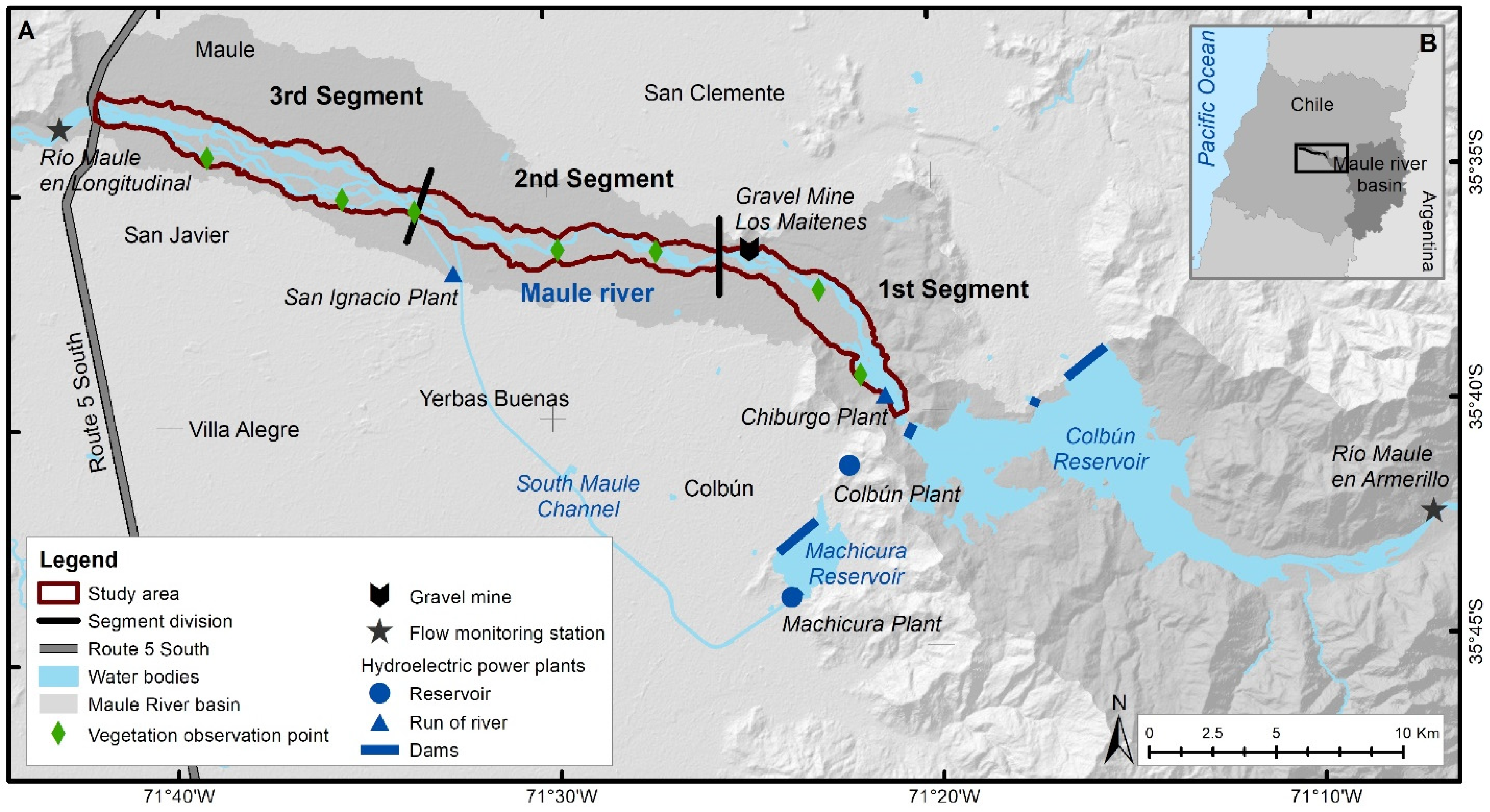
34] of hydroelectric plants in Chile. However, geomorphological and land cover change aspects are topics still in need of attention. Against this backdrop, the Maule River basin (35° S), located in central Chile, has one of the largest dam systems for hydroelectricity production in the country, specifically the Colbún–Machicura plants located in the middle–upper part of the basin. The construction of the hydroelectric complex ended in June 1985, flooding more than 50 km
2 and incorporating more than 500 MW of power production into the central interconnected system (SIC).
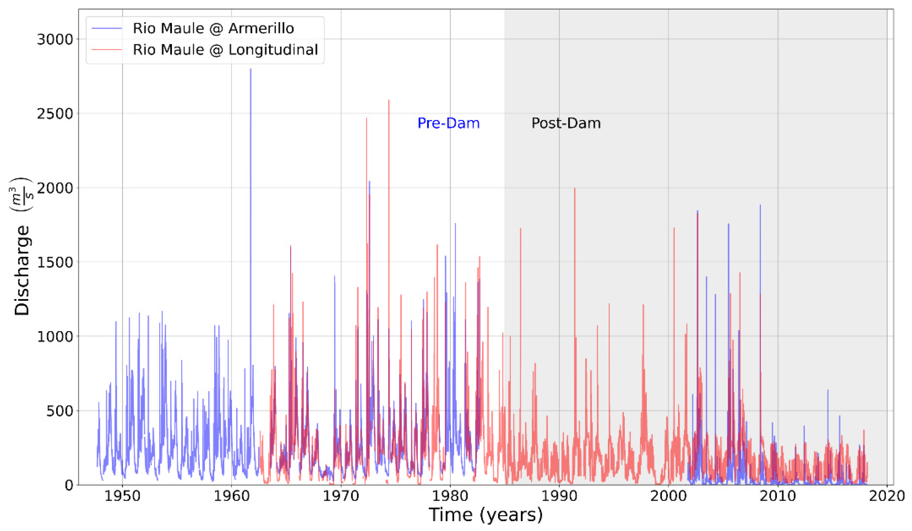
In the period when the plant was built, such projects did not require rigorous environmental assessments and were evaluated mainly based on their benefits. Studies indicate that the effects of dams have become apparent only in recent decades, once they have been in operation for 20 to 30 years [
10]. In addition, the quantification of their impacts is complicated, given a large number of variables involved and the different time scales at which they occur [
35]. The increase in energy and water demand in Chile suggests that such studies are necessary to understand the cause–effect relationships at local and regional scales and thereby provide better tools for water management. Thus, evaluating channel morphology and land cover changes in a middle section of the Maule River, emphasizing vegetation distribution after the Colbún dam began to operate, is an important topic of study. To complement the remote sensing analysis used to assess and classify land cover changes, a tree and shrub species identification was carried out in the field at in situ observation points to improve classification. The identified land cover changes were analyzed based on the magnitude and frequency of flows, on which data was collected from two available gauging stations located along the main river course. The results will provide new information on the impacts of large reservoirs in south-central Chile fluvial systems.
4. Discussion
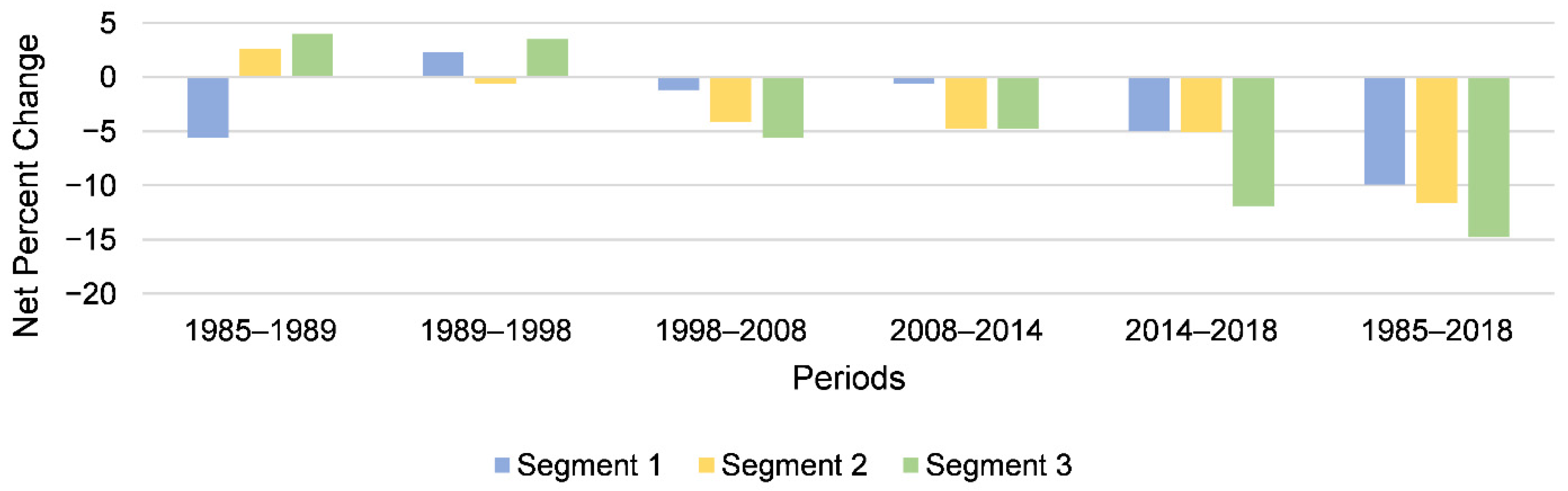
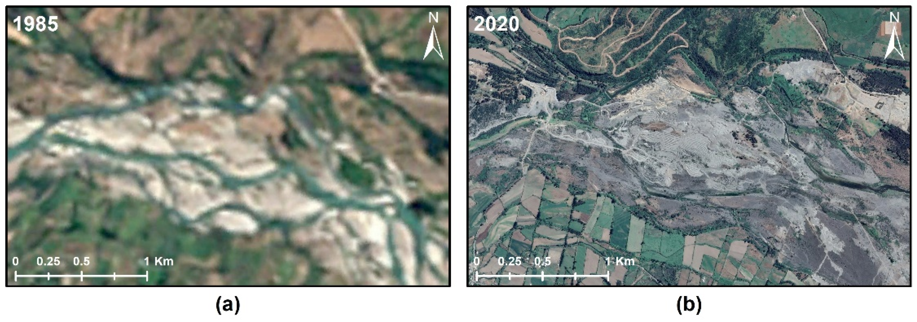
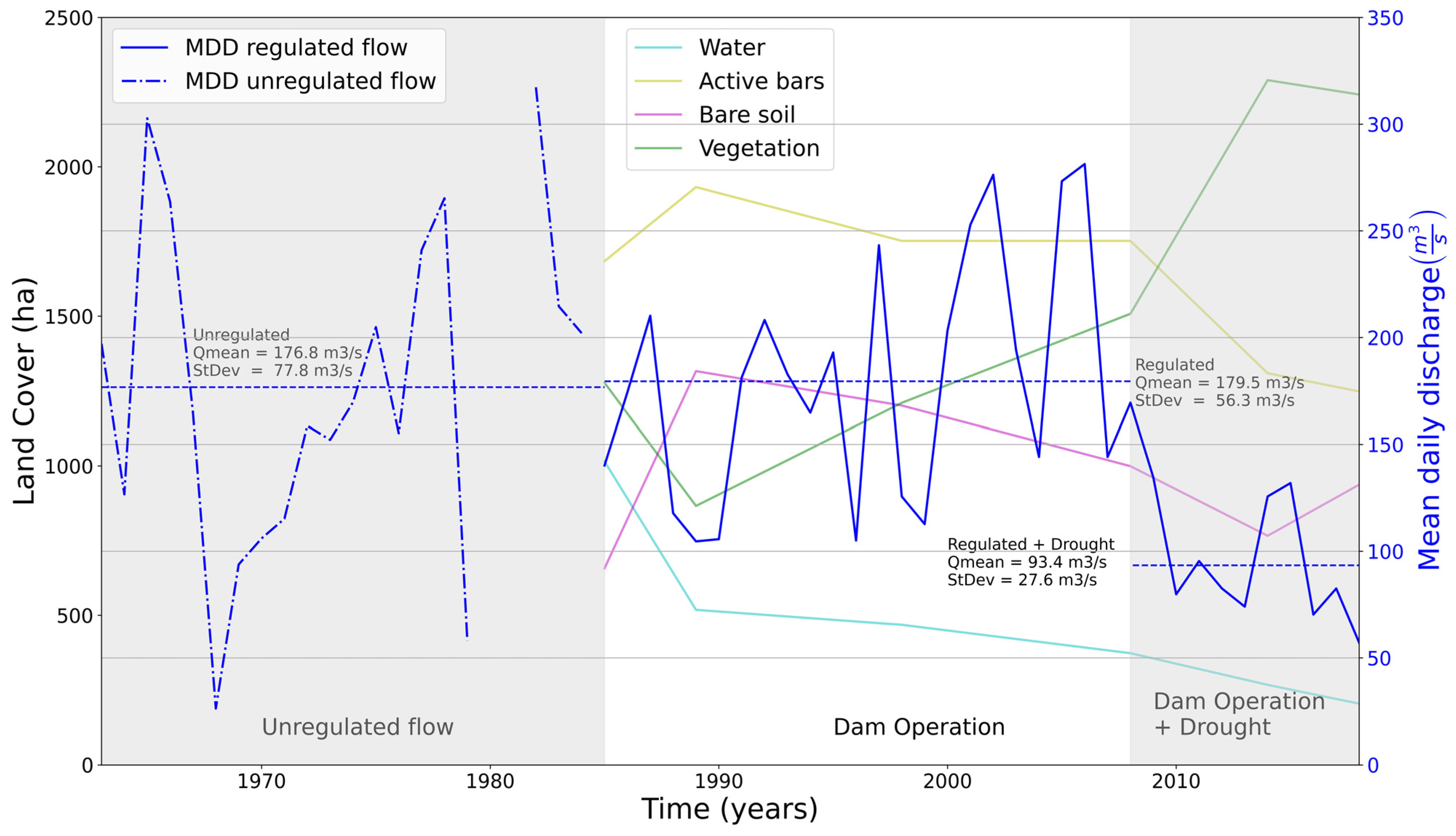
The Colbún–Machicura hydroelectric plants were, at the time, the largest hydroelectricity generation complex in Chile. The end of construction and the start of their operations coincided with the first year analyzed in this study (1985). According to the results, their operation directly affected the morphological equilibrium and vegetation dynamics of the middle section of the Maule River. However, other drivers have probably accelerated the detected changes (i.e., gravel mining, and effects of the megadrought since 2010).
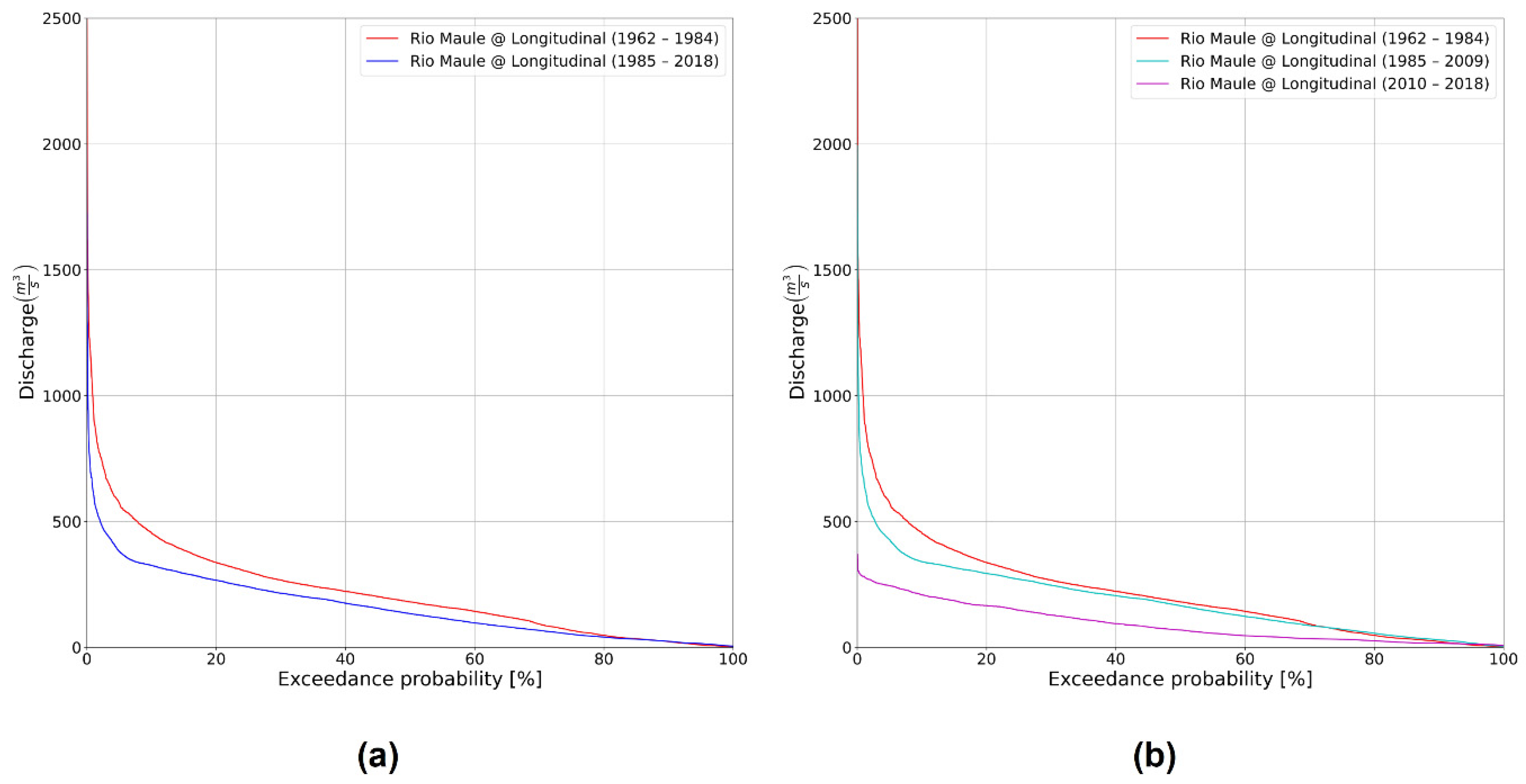
The Maule River (35° S) underwent a 12% reduction in its active area over 33 years, a trend similar to those reported by other authors who have assessed the impacts of dam construction and operation on the fluvial geomorphology and vegetation of rivers. Similar percentages were found in wandering rivers in arid climate zones, including the Green River (40° N) in Colorado, which presented an 11% reduction over 56 years [
56], and the Sauce Grande River (38° S) in Argentina, which decreased by 6–30% in 21 years [
57]. In some braided rivers the reduction percentages are even more remarkable, in both Mediterranean climate zones, as in the case of the Piave River (46° N) in Italy, where narrowing left the river with only 35% of its original width over a period of 97 years [
21], and arid climates, as in the case of the Río Grande (35° S) in New Mexico, where a 70% reduction in 83 years was observed [
22].
Nonetheless, not all authors have observed absolute change trends or trends that remain over time. For example, Nelson et al. [
58], who studied the Snake River (43° N) in Wyoming, USA, measured a channel narrowing that reached 31% in the first 24 years after dam operation began; however, after a period of large floods, the change reversed almost entirely as the banks eroded and the river area increased by 31%. Vericat and Batalla [
59], meanwhile, in an analysis of the sedimentary balance and morphology of the Ebro River (42° N) in Spain, observed a reduction in channel width that reached 20%. Nonetheless, they also highlighted zones that presented accretion due to lateral erosion processes that became the river’s only sediment source after the dam was installed. However, this is not the case with the Maule River, as the insignificant zones with accretion are typically associated with anthropogenic pressures.
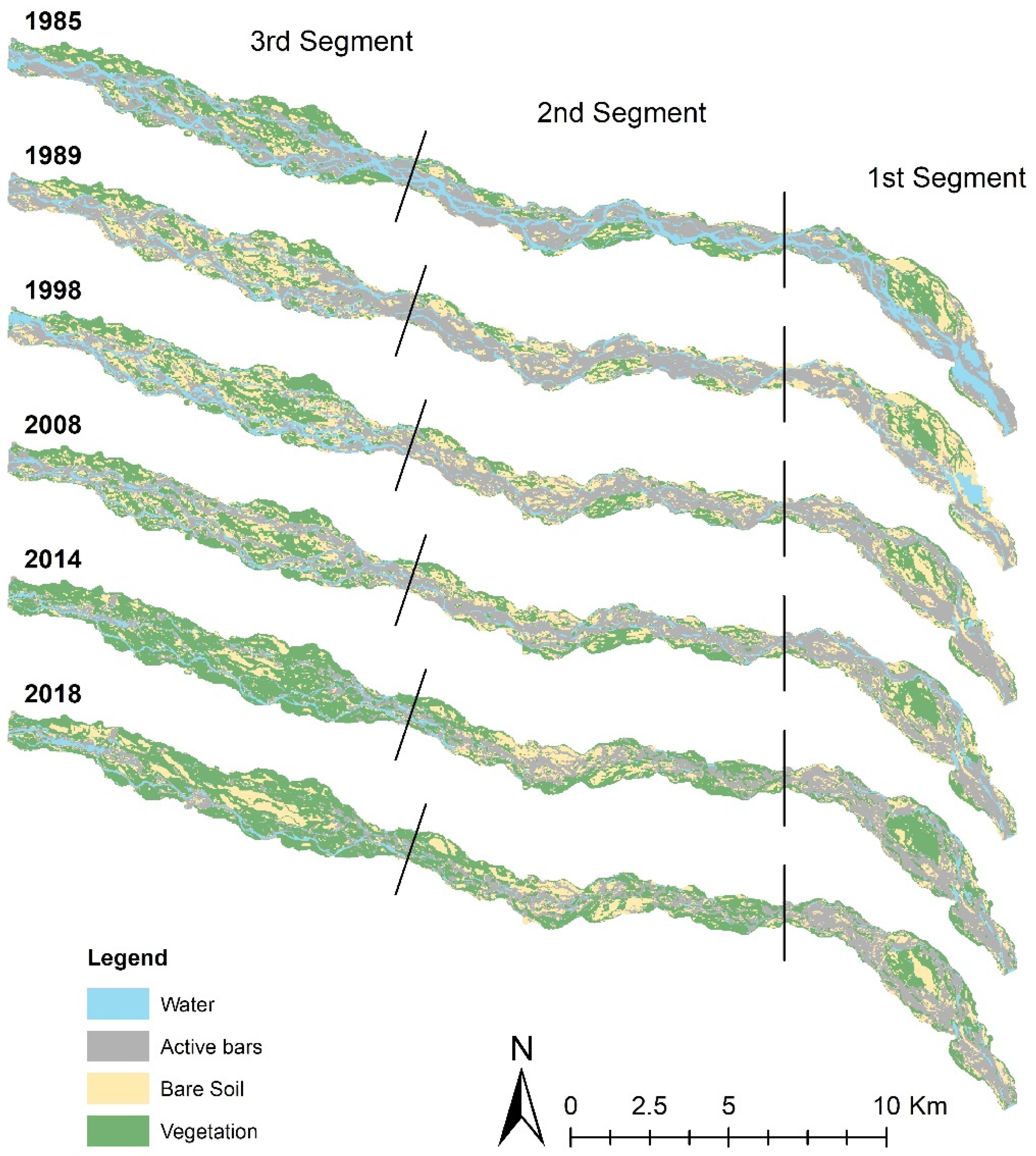
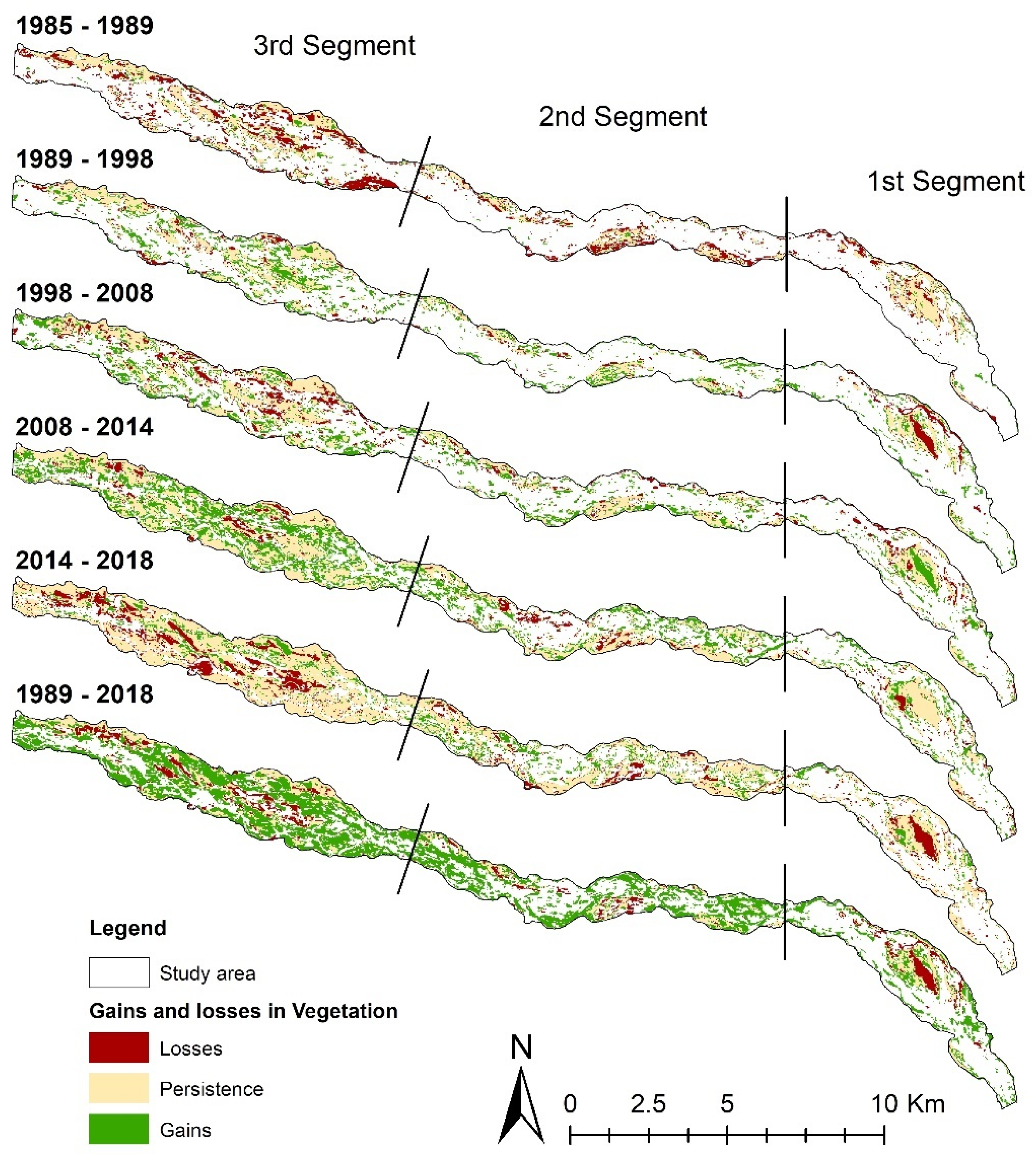
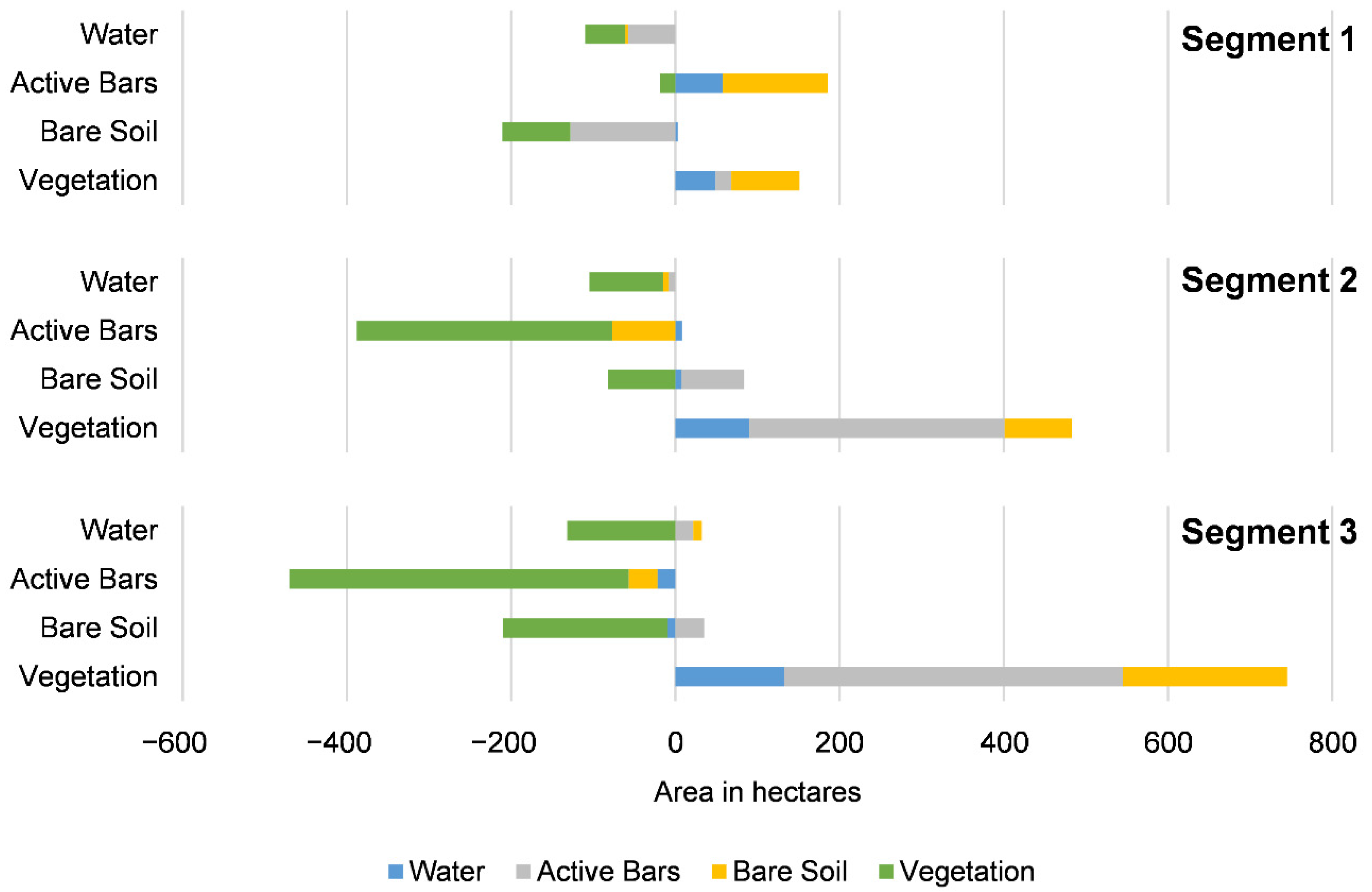
Additionally, the narrowing of the active area could be related to the data obtained on gains and losses of the different land covers. Indeed, more than half of the vegetation gains took place on active bars throughout the study area, a percentage that increased to 80% in the farthest segments (i.e., 2 and 3), where vegetation increased by an average of 215% in the 1989–2018 period. The trends are consistent with the findings of other authors, who analyzed the effects of dam construction on vegetation. For example, in a study covering more than 70 segments in four large basins of the Iberian Peninsula, Lobera et al. [
23] found that almost all the previously active bars in the most regulated segments had stabilized due to vegetation colonization. Meanwhile, Tealdi et al. [
60], to model the impacts of regulation on vegetation, compiled the results of various studies, which mainly reported a significant increase in vegetation zones, with an upward trend in exotic species over native species.
The results show that the distance factor plays a role in the observed effects on vegetation. Segment 1, the closest to the dam, presented the least successful colonization, which could be associated with less favorable factors such as unusual discharges that generate flood pulses, and more extensive bed slopes and, therefore, more significant flow velocity. It is also essential to consider recent anthropogenic factors in this segment (i.e., deforestation and gravel mining), which have increased due to the low flows, and cover large areas and directly affect the channel form and vegetation distribution. In the case of the two more distant segments, gravel mining takes place in a smaller area, and there are no forestry plantations. In addition, segment 3 receives flows from the hydroelectric restitution canals located 22 km downstream of the main wall, which do not exceed 10 m
3/s; therefore, their flow is not significant relative to the main channel. Furthermore, the findings are consistent with Gordon and Meentemeyer [
61]. Their study compared regulated and unregulated segments in the Dry Creek (38° N), a tributary of the Russian River in California; they divided the river into 10 sub-segments and found that the vegetation increase was more significant in the farthest segments.
Regarding the temporality of the changes, according to Lobera et al. [
23], the system needs time to generate observable effects for bar stabilization. For example, Merrit and Cooper [
56] observed vegetation colonization in almost all the active bars of the studied segment of the Green River; these changes were observable 10 years after dam closure. In the case of the Maule River, such changes began to be observed between 1989 and 1998, although they presented a greater increase in the 2008–2018 period.
There have been no similar studies focusing on vegetation changes in Chile in other dammed Mediterranean rivers; however, Batalla et al. [
42] investigated the Ñuble River (36° S), an Andean fluvial system without major human interventions. In their analysis of approximately 10 years, with high-resolution satellite images, they showed that the system had undergone a progressive reduction in geomorphic activity in the last decade due to the decrease in flood flows that facilitated the colonization and stabilization of bars.
Notwithstanding the vast difference in intervention between the two rivers, the results obtained were similar to those achieved in the Maule River, especially with the explosive increase in vegetation covers in the lower segments between 2008 and 2018. Thus, the increase in vegetation beginning in 2008 seems to be boosted by the hydrological phenomenon known as the megadrought [
62]. According to Garreaud et al. [
63], who analyzed the phenomenon from a climate dynamics perspective, the drought that has affected central Chile from 2010 to date has brought about a decrease in precipitation, causing a deficit of 20 to 40% in the Maule River basin. Thus, future investigations could consider the combined effect of the flow regulation of the dam and the decrease in flows associated with the megadrought described in the previously mentioned studies.
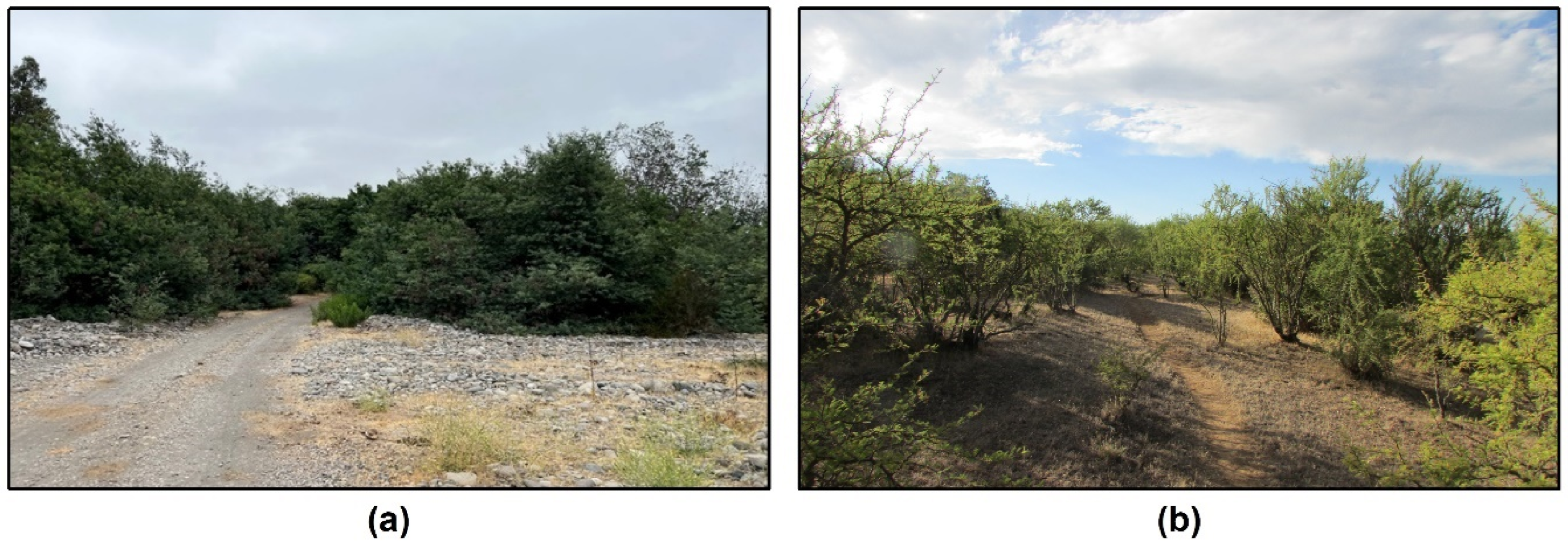
The climate fluctuations that have had Chile in a state of high alert for so many years seem to explain the similarity of the effects on the geomorphic dynamics of the Ñuble and Maule rivers; however, it is not possible to fully attribute them to these factors. The reality is that the Maule River is under multiple pressures: flow reduction due to climate variability and change, creation of various large gravel mining sites in the last decade, deforestation, and invasion of exotic species, among others, the effects of which are significantly heightened by the regulatory effects of the dams.
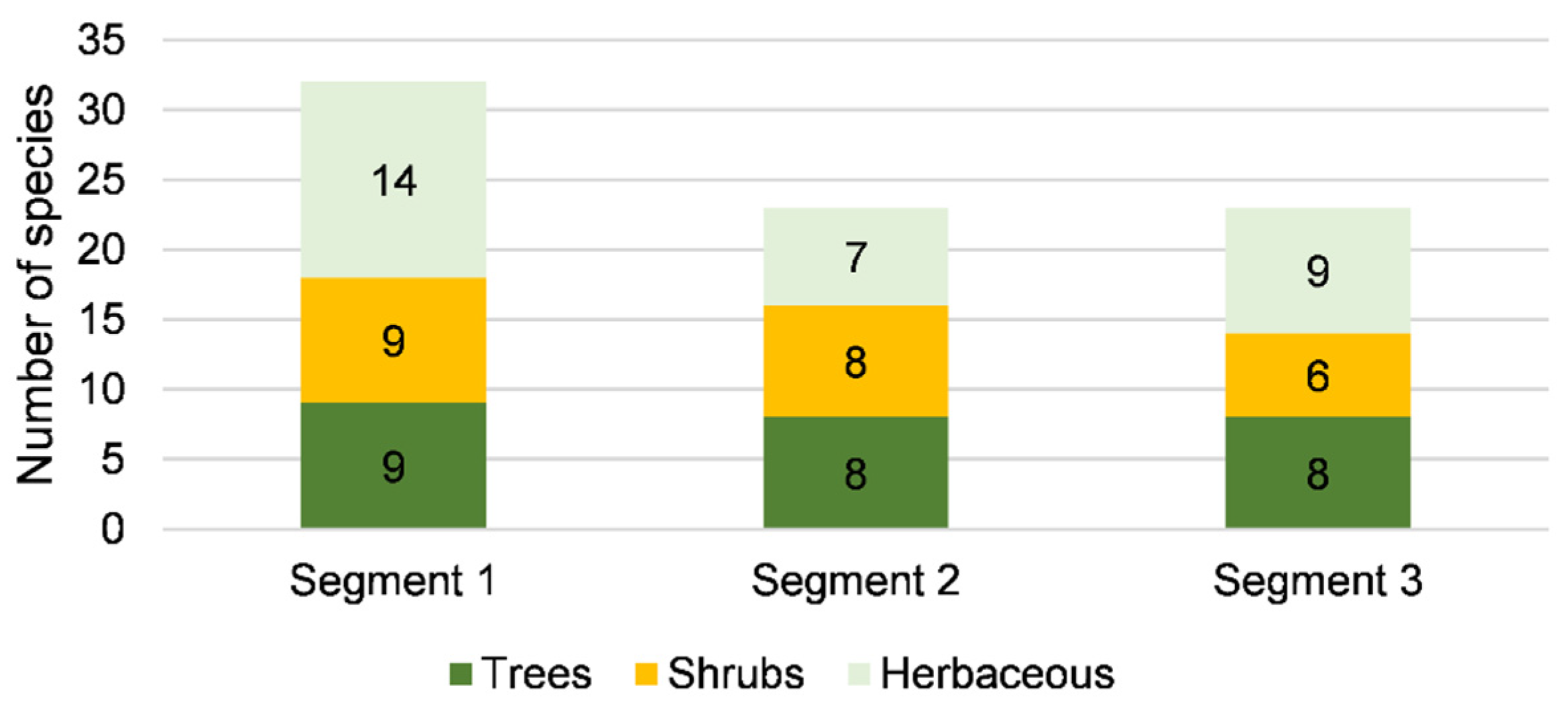
Regarding species identification in the Maule River, the high presence of exotic species and the specific predominance of
Acacia dealbata (silver wattle) are consistent with the conditions present in the study area. Similarly, Fuentes-Ramírez et al. [
64] studied the dynamics of silver wattle invasion in south-central Chile. Their study highlights that the species is often successful in “uninvaded areas” and can also take advantage of disturbances to establish itself while limiting the development of native species. This success may be due to its high capacity for colonization, allowing it to assume control of sites that have been disturbed and pose a threat to natural habitats by competing with and replacing native species, decreasing native biodiversity and homogenizing the community. These previous findings explain how the high presence of
Acacia dealbata in segments 2 and 3 could be related to their lower species diversity. Finally, the presence of these tree species could significantly impact future flooding processes by increasing channel roughness; floods under these conditions have been reported in other coastal Mediterranean rivers of Chile [
65,
66].
5. Conclusions
The middle section of the Maule River has undergone a notable reduction in geomorphic activity since 1985. Moreover, the boundaries of its active areas have been pressured by the advance of vegetation on its banks, which stabilized and changed the morphological configuration of the channel. The effects translated into an overall reduction in the active area of 12% between 1985 and 2018. Furthermore, the drought has played a significant role in augmenting these impacts on the river system within this period. These results suggest that the flow’s regulating effect, combined with the drought, has considerable consequences for the hydrologic regime. If low rainfall persists, significant reductions in high flows are expected, with a subsequent decrease in morphological work.
Within the active channel, there was a gradual increase in vegetation-covered surface area, which reached 159% between 1989 and 2018, and occurred at the expense of a reduction in water (−61%), active bar (−35%), and bare soil (−29%) areas. The variations reached a significant point between 2008 and 2014, when around 800 ha was stabilized in less than five years. The areas not colonized/stabilized by vegetation are usually linked to human activities such as gravel mining, logging, and agriculture. The extensive increases in vegetation surface area will imply higher discharges for significant geomorphic work, thus favoring vertical erosion with a concurrent decrease in water surface elevation and the connected water table.
The observed hydrological changes and regulated discharge effects play an important role for vegetation growth, especially that of invasive species that prevail in the study area. Tree and shrub species have the greatest presence in Maule River (Acacia dealbata, or silver wattle) and are in some cases associated with plantations (Eucalyptus nitens and Pinus radiata). Species such as silver wattle have advantages over native species, as they are specialists at colonizing by taking advantage of anthropogenic disturbances and alterations. The abundant vegetation will not only restrict the lateral channel displacement but could be a potential risk for future floods due to the resulting increase in roughness.


