
Response of Channel Morphology to Climate Change over the Past 2000 Years Using Vertical Boreholes Analysis in Lancang River Headwater in Tibetan Plateau

Abstract
:1. Introduction
2. Date and Methods
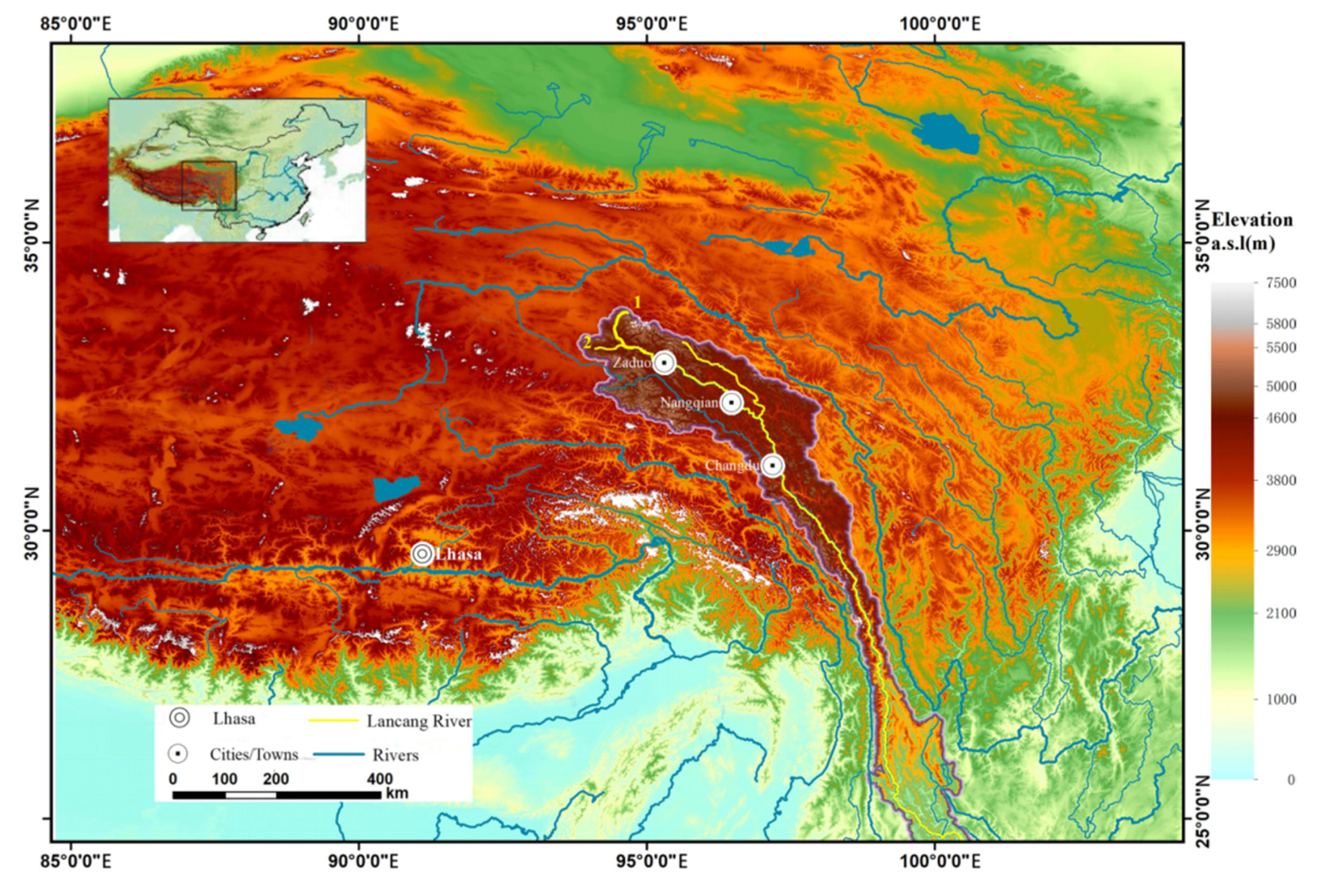
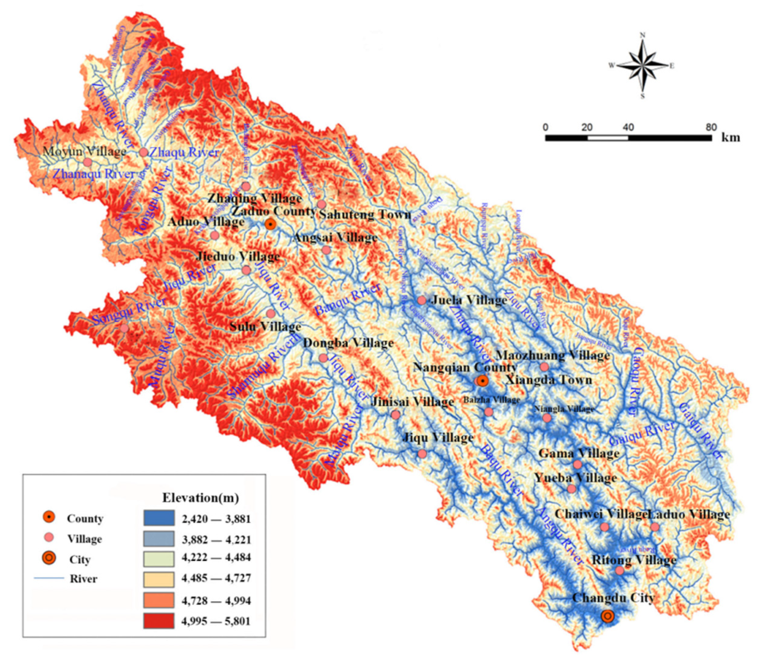
2.1. Study Area
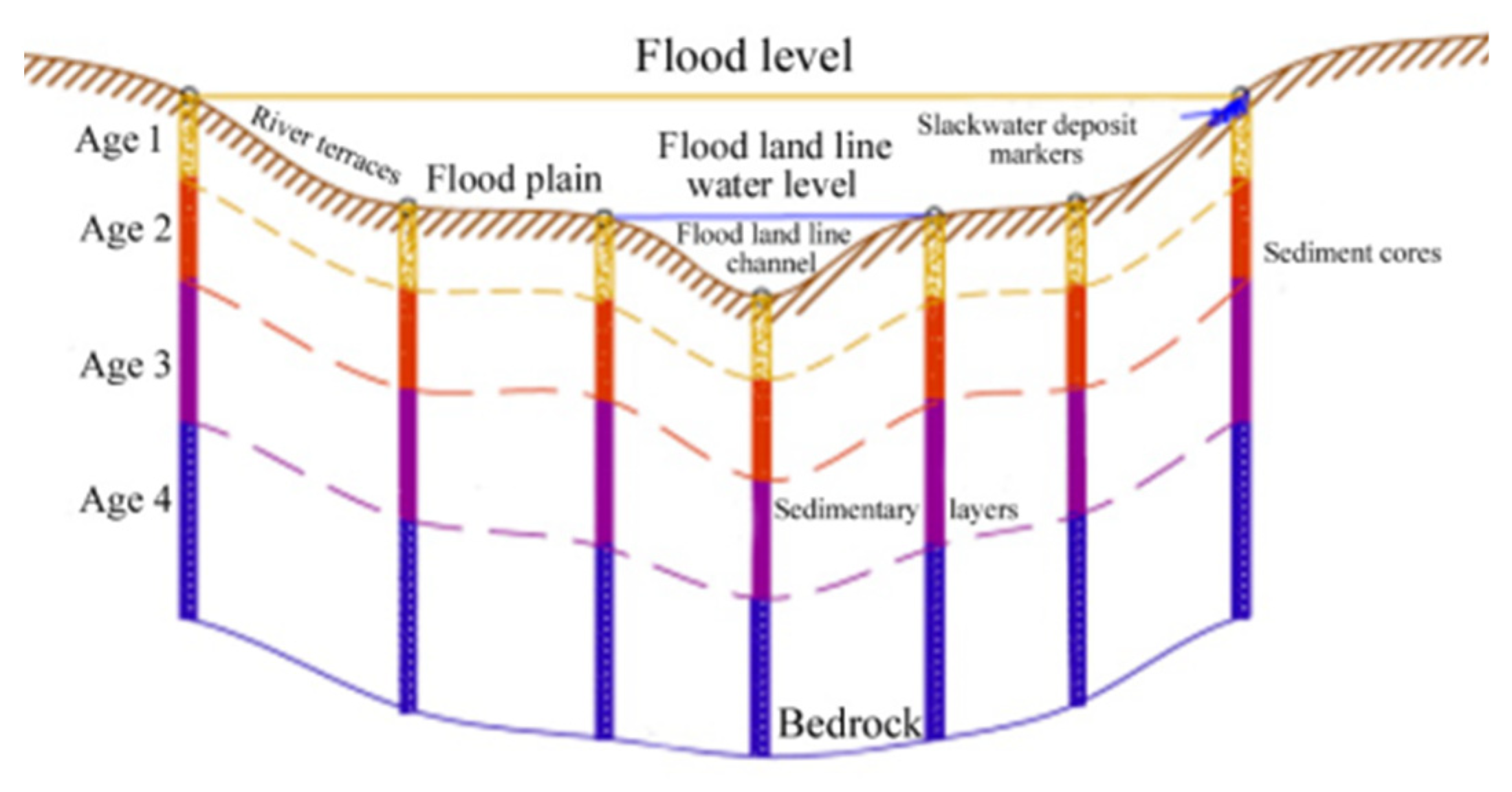
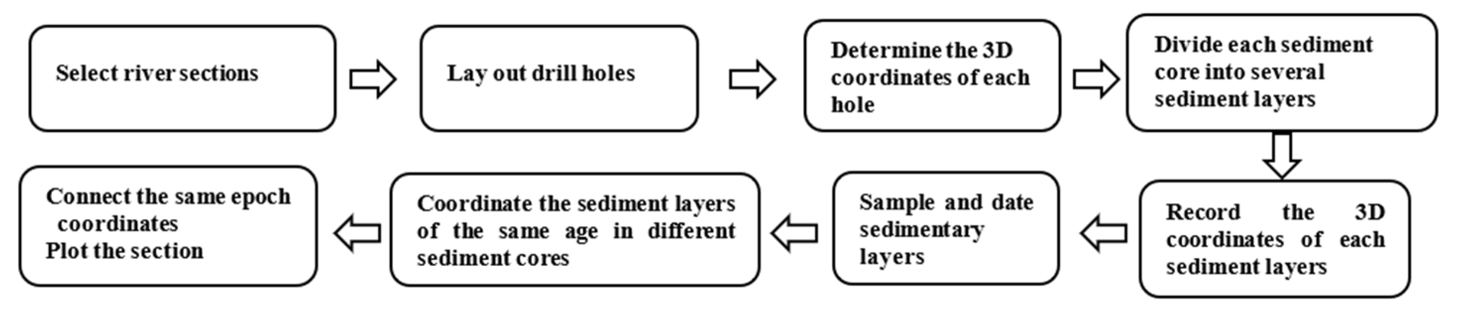
2.2. Historical River Morphology Recovery in Data-Poor Areas
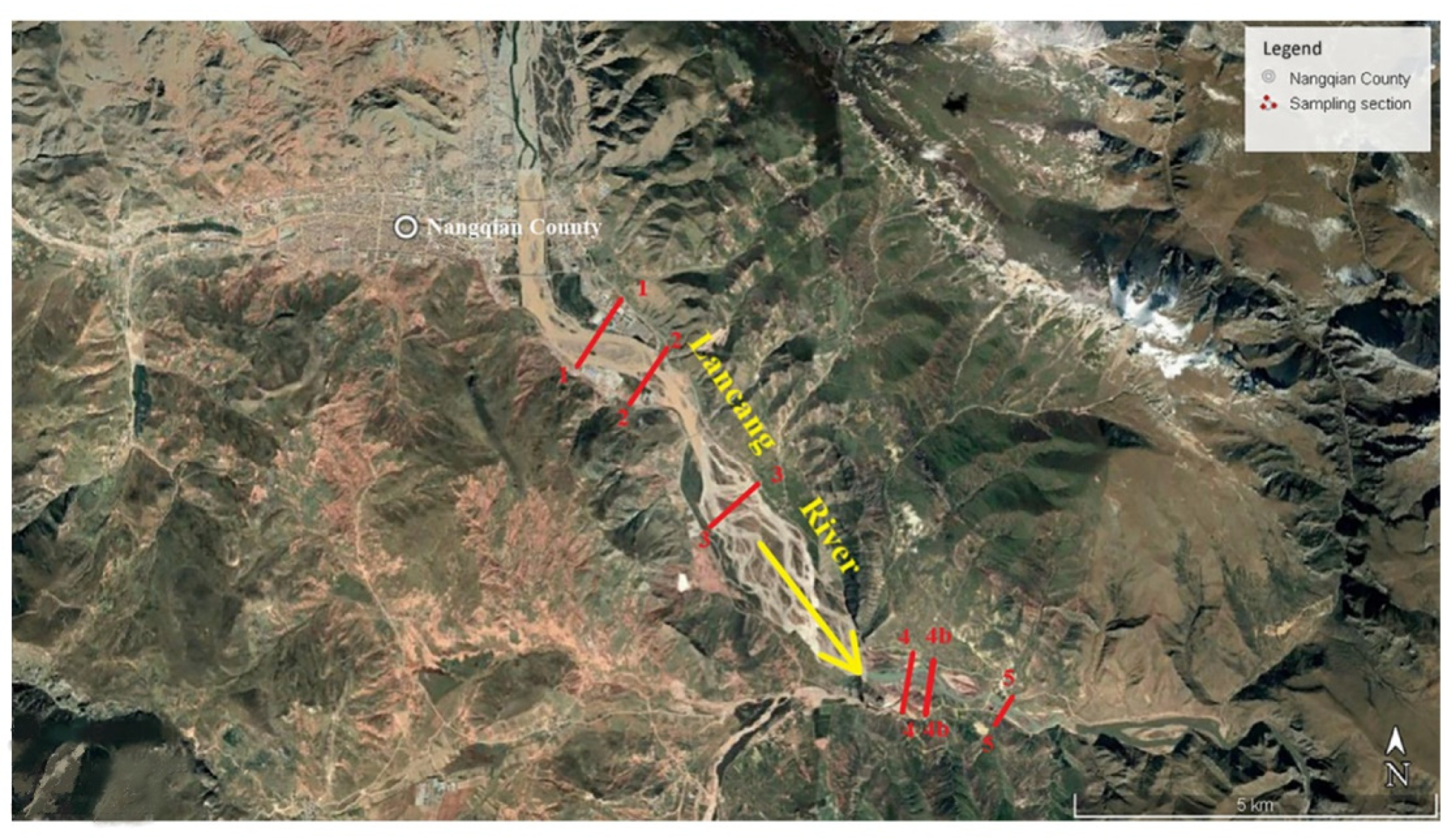
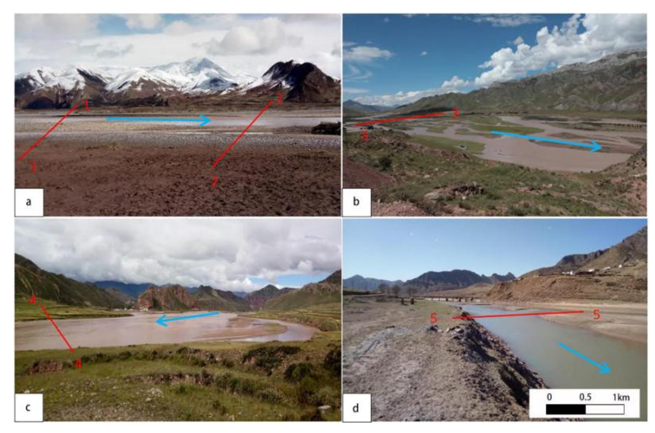
2.3. Sample Collection
2.4. Luminescence Dating
2.4.1. Luminescence Sample Collection and Pre-Treatment
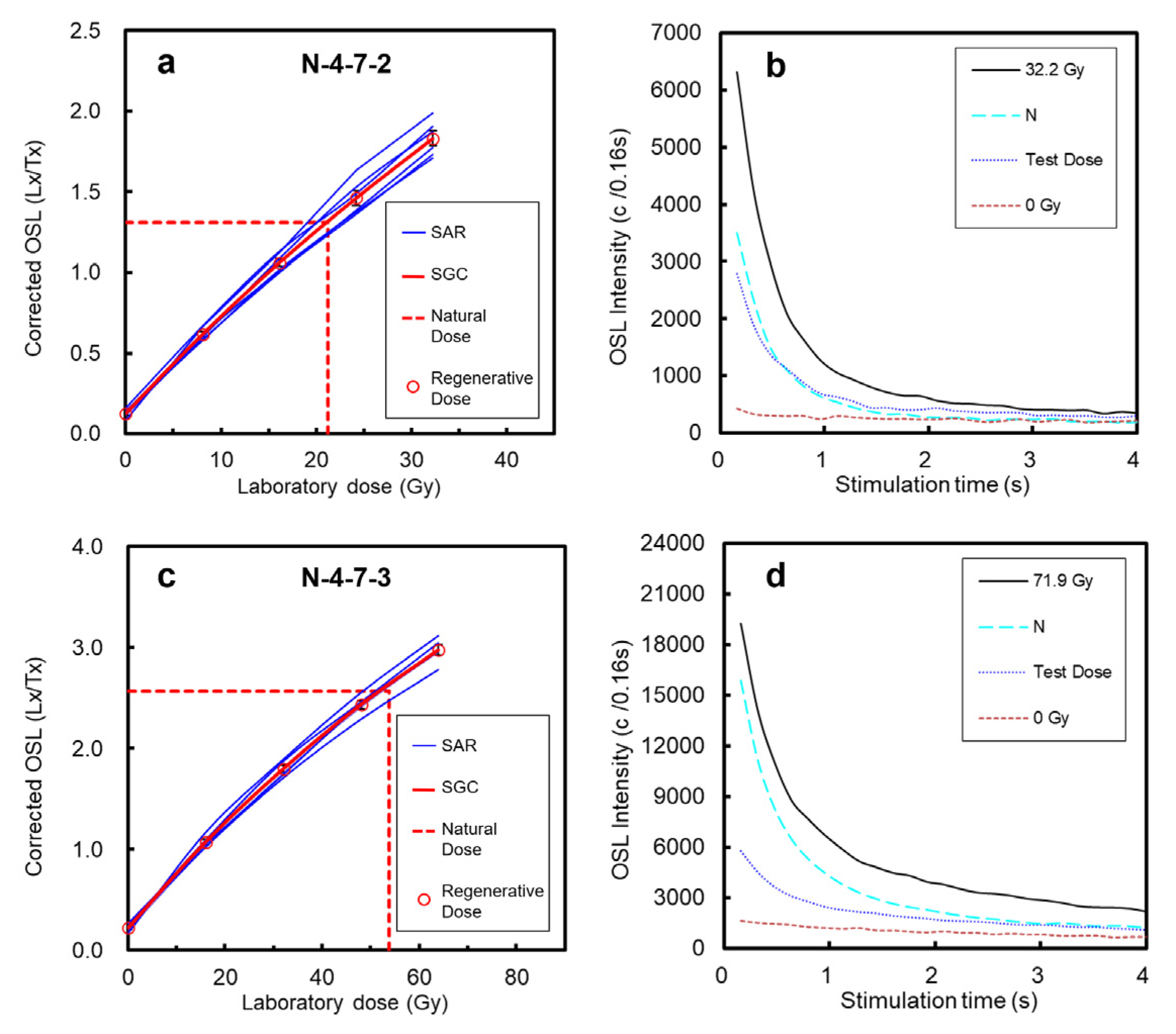
2.4.2. Equivalent Dose (De) Determination
2.4.3. Environmental Dose Rate Determination
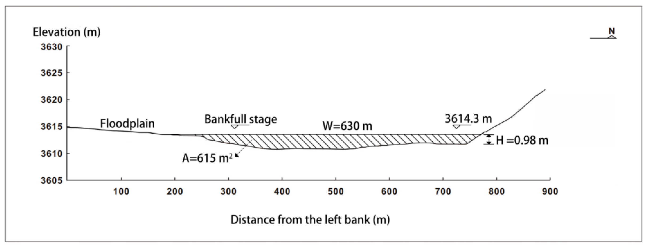
2.5. Calculation of Bankfull Area
3. Results and Discussions
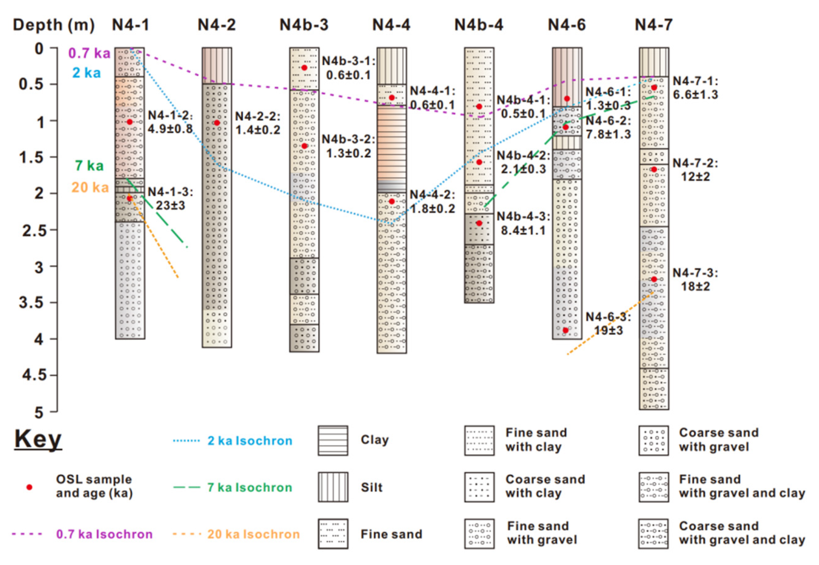
3.1. Characterization of Sediments Layers in Boreholes in Each Sampling Section
3.2. OSL Dating Results
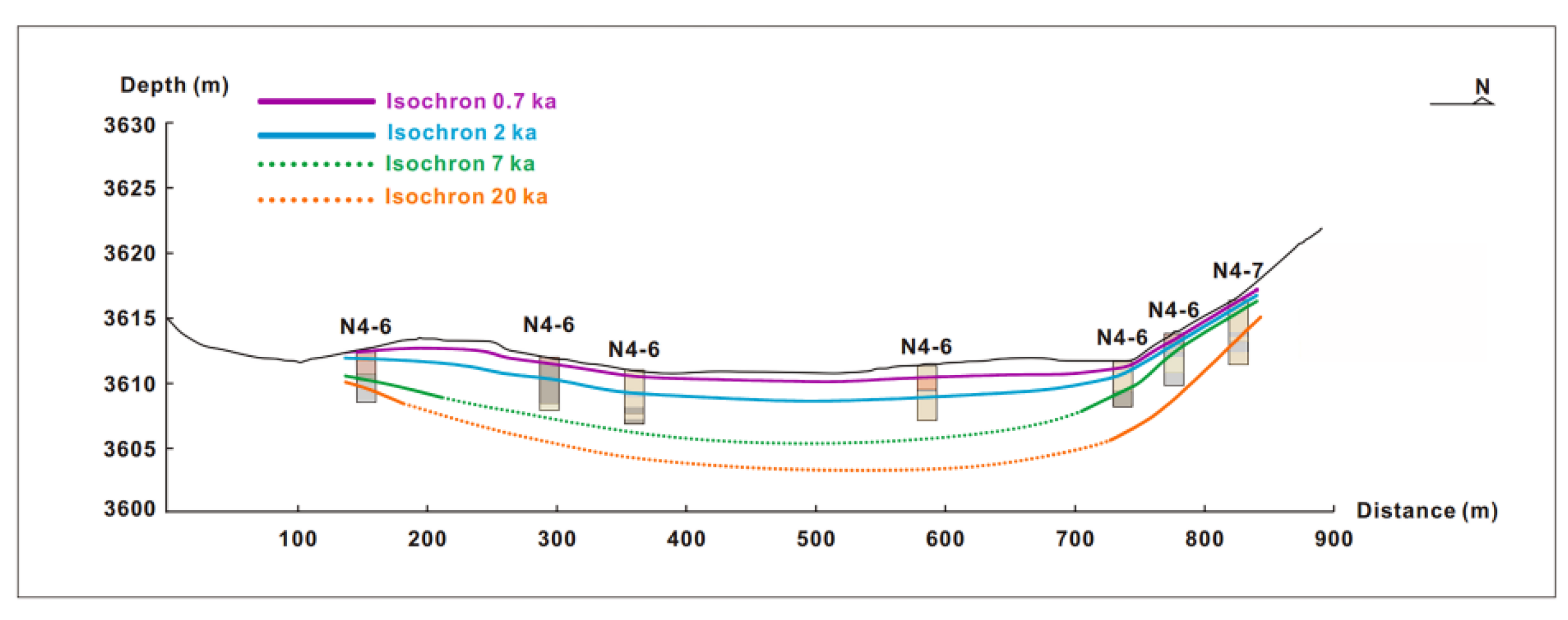
3.3. Historical Morphological Recovery for the Typical Cross-Sections and Their Response to Climate Change
4. Conclusions
- (1)
- The majority of riverbed sediments of the Nangqian reach in the Lancang River source were primarily channel-transported sediments deposited by the downstream canyon congestion since 2 ka. The general morphological cross-sections at 0.7 ka, 2 ka, and contemporary are consistent. The thalweg location of the 2 ka section was similar to the present, while that of the 0.7 ka section was to the right bank. However, the area of the 2 ka section was significantly larger than at present, while no such significance was observed between the areas at 0.7 ka and the present.
- (2)
- The alluvial riverbed section, notably dominated by the accumulative process, was selected for OSL dating on the stratified riverbed units, such as river terraces and floodplains. Dating results allowed for the possibility of recovering the historical, generalized cross-sections.
- (3)
- The larger areas, recorded at 0.7 ka and 2 ka, recovered from the river morphology, are comparable to the present (1.28 and 1.9 times larger, respectively), reflecting the strong water and sediments transport capacity of this river section during the historical warm periods.
- (4)
- This research will not only provide a basis for an in-depth understanding of the hydrological change process of the Lancang River source in the historical period, but it will also provide a solid basis for the discussion of paleohydrology and paleoenvironment.
Author Contributions
Funding
Institutional Review Board Statement
Informed Consent Statement
Data Availability Statement
Conflicts of Interest
References
- Zhou, Y.J.; Yan, X.; Jin, Z.W.; Li, Z.J. Preliminary Analysis on River Pattern Discrimination of Moyun Reach in Zhanaqu of Lantsang River Source. J. Yangtze River Sci. Res. Inst. 2016, 33, 29–34. [Google Scholar] [CrossRef]
- Zhou, S.; Zhou, Y.J.; Yan, X.; Fan, B.L. Sediment distribution on Nangqian Reach in the source area of Lancang River. J. Sediment Res. 2019, 44, 46–52. [Google Scholar] [CrossRef]
- Nash, D.J. Drainage development, neotectonics and base-level change in the Kalahari Desert, southern Africa. South Afr. Geogr. J. 2015, 98, 308–320. [Google Scholar] [CrossRef] [Green Version]
- Wang, S.; Li, L. Lateral shift rate variation of the river banks in the Yinchuan Plain reach of the Yellow River and its causes. Dili Xuebao Acta Geogr. Sin. 2014, 69, 399–408. [Google Scholar] [CrossRef]
- Yao, Z.; Ta, W.; Jia, X.; Xiao, J. Bank erosion and accretion along the Ningxia-Inner Mongolia reaches of the Yellow River from 1958 to 2008. Geomorphology 2010, 127, 99–106. [Google Scholar] [CrossRef]
- Mao, F.; Huang, J.; Hu, Q.; Zhou, W.; Li, Q.; Liu, Z. Analysis of ev-olution of rivers and driving force in the Qingkou region based on multi-source remote sensing data. J. Tsinghua Univ. (Sci. Technol.) 2009, 49, 313–316. [Google Scholar] [CrossRef]
- Arnez Ferrel, K.R.; Nelson, J.M.; Shimizu, Y.; Kyuka, T. Past, present and future of a meandering river in the Bolivian Amazon basin. Earth Surf. Process. Landf. 2021, 46, 715–727. [Google Scholar] [CrossRef]
- Li, Z.W.; Wang, Z.Y.; Yu, G.A. River pattern transition and its causes along Maqu reach of Yellow River source region. J. Sediment Res. 2013, 3, 51–58. [Google Scholar] [CrossRef]
- Lombardo, U. Alluvial plain dynamics in the southern Amazonian foreland basin. Earth Syst. Dyn. 2016, 7, 453–467. [Google Scholar] [CrossRef] [Green Version]
- Cohen, T.J.; Nanson, G.C. Topographically associated but Chronologically disjunct late Quaternary floodplains and terraces in a partly confined valley, south-eastern Australia. Earth Surf. Processes Landf. 2008, 33, 424–443. [Google Scholar] [CrossRef]
- Daley, J.; Croke, J.; Thompson, C.; Cohen, T.; Macklin, M.; Sharma, A. Late Quaternary channel and flood plain formation in a partly Confined subtropical river, eastern Australia. J. Quat. Sci. 2017, 32, 729–743. [Google Scholar] [CrossRef]
- Wu, Q. Huge prehistoric flood events found on Jinsha and Yarlung Tsangpo rivers. J. Nanjing Norm. Univ. (Nat. Sci. Ed.) 2019, 42, 163–164. [Google Scholar] [CrossRef]
- Jiang, G.Q.; Huang, J.J.; Zhang, D.L.; Xu, S.Y.; Lu, J.T. Research on geoelectric characteristics of Holocene ancient channels in Xuzhou area. Geophys. Geochem. Explor. 2018, 42, 422–428. [Google Scholar] [CrossRef]
- Sánchez Vuichard, G.; Stutz, S.; Tonello, M.S.; Navarro, D.; Schmelz, M.; Fontana, S.L. Structure and dynamics of a Pampa plain, (Argentina) shallow lake over the last 600 years. J. Paleolimnol. 2021, 66, 141–155. [Google Scholar] [CrossRef]
- Lim, J.; Lee, J.Y.; Hong, S.S.; Kim, J.Y. Late Holocene flooding records from the floodplain deposits of the Yugu River. South Korea. Geomorphol. 2013, 180–181, 109–119. [Google Scholar] [CrossRef]
- Nivière, B.; Lacan, P.; Regard, V.; Delmas, M.; Calvet, M.; Huyghe, D.; Roddaz, B. Evolution of the Late Pleistocene Aspe River (Western Pyrenees, France). Signature of climatic events and active tectonics. Comptes Rendus-Geosci. 2016, 348, 203–212. [Google Scholar] [CrossRef]
- Fu, X.; Li, S.H. A modified multi-elevated-temperature post-IR IRSL protocol for dating Holocene sediments using K-feldspar. Quat. Geochronol. 2013, 17, 44–54. [Google Scholar] [CrossRef]
- Kaiser, K.; Lai, Z.P.; Schneider, B.; Junge, F.W. Late Pleistocene genesis of the middle Yarlung Zhangbo Valley, southern Tibet (China), as deduced by sedimentological and luminescence data. Quat. Geochronol. 2010, 5, 200–204. [Google Scholar] [CrossRef]
- Liu, W.M.; Lai, Z.P.; Hu, K.H.; Ge, Y.G.; Cui, P.; Zhang, X.G.; Liu, F. Age and extent of a giant glacial-dammed lake at Yarlung Tsangpo gorge in the Tibetan Plateau. Geomorphology 2015, 246, 370–376. [Google Scholar] [CrossRef]
- Zhang, J.R.; Lai, Z.P.; Jia, Y.L. Luminescence chronology for late Quaternary lake levels of enclosed Huangqihai Lake in East Asian monsoon marginal area in northern China. Quat. Geochronol. 2012, 10, 123–128. [Google Scholar] [CrossRef]
- Han, W.X.; Ma, Z.B.; Lai, Z.P.; Appeld, E.; Fang, X.M.; Yu, L.P. Wind erosion on the northern-eastern Tibetan Plateau: Constraints from OSL and U-Th dating of playa salt crust in the Qaidam Basin. Earth Surf. Processes Landf. 2014, 39, 779–789. [Google Scholar] [CrossRef]
- Lai, Z.P. Chronology and the upper dating limit for loess samples from Luochuan section in Chinese Loess Plateau using quartz OSL SAR protocol. J. Asian Earth Sci. 2010, 37, 176–185. [Google Scholar] [CrossRef]
- De Moor, J.J.W.; Kasse, C.; Van Balen, R.; Vandenberghe, J.; Wallinga, J. Human and climate impact on catchment development during the Holocene-Geul River, The Netherlands. Geomorphology 2008, 98, 316–339. [Google Scholar] [CrossRef]
- Xu, Y.T.; Tian, T.; Shen, Q.J.; Luo, L.; Lai, Z.P. Late Quaternary aggradation of the Datong Basin in northern China revealed by OSL dating of core sediments and implications for groundwater arsenic pollution. Catena 2021, 207, 105650. [Google Scholar] [CrossRef]
- Xu, X.L.; Li, H.W.; Tang, L.J.; Lai, Z.P.; Xu, G.J.; Zhang, X.H.; Wang, Y.X. Chronology of a Holocene core from the Pearl River delta in southern China. Front. Earth Sci. 2020, 8, 262. [Google Scholar] [CrossRef]
- Notebaert, B.; Verstraeten, G. Sensitivity of West and Central European river systems to environmental changes during the Holocene: A review. Earth-Sci. Rev. 2010, 103, 163–182. [Google Scholar] [CrossRef]
- Lai, Z.P.; Kaiser, K.; Brückner, H. Luminescence dated aeolian deposits of late Quaternary age in the southern Tibetan Plateau and their implications for landscape history. Quat. Res. 2009, 72, 421–430. [Google Scholar] [CrossRef]
- Grygar, T.M.; Nováková, T.; Mihaljevič, M.; Strnad, L.; Světlík, I.; Koptíková, L.; Lisá, L.; Brázdil, R.; Máčka, Z.; Stachoň, Z.; et al. Surprisingly small increase of the sedimentation rate in the floodplain of Morava River in the Strážnice area, Czech Republic, in the last 1300 years. Catena 2011, 86, 192–207. [Google Scholar] [CrossRef]
- Lai, Z.P.; Ou, X.J. Basic procedures of optically stimulated luminescence (OSL) dating. Prog. Geogr. 2013, 32, 683–693. [Google Scholar] [CrossRef]
- Duller, G. Distinguishing quartz and feldspar in single grain luminescence measurements. Radiat. Meas. 2003, 37, 161–165. [Google Scholar] [CrossRef]
- Lai, Z.P.; Brueckner, H. Effects of feldspar contamination on equivalent dose and the shape of growth curve for OSL of silt-sized quartz extracted from Chinese loess. Geochronometria 2008, 30, 49–53. [Google Scholar] [CrossRef] [Green Version]
- Murray, A.S.; Wintle, A.G. Luminescence dating of quartz using an improved single-aliquot regenerative-dose protocol. Radiat. Meas. 2000, 32, 57–73. [Google Scholar] [CrossRef]
- Lai, Z. Testing the use of an OSL standardised growth curve (SGC) for De determination on quartz from the Chinese Loess Plateau. Radiat. Meas. 2006, 41, 9–16. [Google Scholar] [CrossRef]
- Huang, X.M.; Miao, X.D.; Chang, Q.F.; Zhong, J.M.; Mason, J.A.; Hanson, P.R.; Ou, X.J.; Xu, L.B.; Lai, Z.P. Tibetan dust accumulation linked to ecological and landscape response to global climate change. Geophys. Res. Lett. 2022, 48, e2021GL096615. [Google Scholar] [CrossRef]
- Liu, X.J.; Lai, Z.P.; Zeng, F.M.; Madsen, D.B. Holocene lake level variations on the Qinghai-Tibetan Plateau. Int. J. Earth Sci. (Geol Rundsch) 2013, 102, 2007–2016. [Google Scholar] [CrossRef]
- Xu, Y.; Lai, Z.; Chen, T.; Gong, S. Late Quaternary optically stimulated luminescence (OSL) chronology and environmental changes in the Hobq Desert, northern China. Quat. Int. 2018, 470, 18–25. [Google Scholar] [CrossRef]
- Prescott, J.R.; Hutton, J.T. Cosmic ray contributions to dose rates for luminescence and ESR dating: Large depths and long-term time variations. Radiat. Meas. 1994, 23, 497–500. [Google Scholar] [CrossRef]
- Aitken, M.J. Introduction to Optical Dating: The Dating of Quaternary Sediments by the Use of Photon-Stimulated Luminescence; Clarendon Press: London, UK, 1998. [Google Scholar]
- Williams, G.P. Bankfull discharge of rivers. Water Resour. Res. 1978, 14, 1141–1154. [Google Scholar] [CrossRef]
- Harman, C.; Stewardson, M.; Derose, R. Variability and uncertainty in reach bankfull hydraulic geometry. J. Hydrol. 2008, 351, 13–25. [Google Scholar] [CrossRef]
- Leopold, L.B.; Maddock, T. The Hydraulic Geometry of Stream Channels and Some Physiographic Implications; US Geological Survey Professional Paper No. 252; United States Goverment Printing Office: Washington, DC, USA, 1953. [Google Scholar]
- Stewardson, M. Hydraulic geometry of stream reaches. J. Hydrol. 2005, 306, 97–111. [Google Scholar] [CrossRef]
- Wohl, E.; Wilcox, A. Channel geometry of mountain streams in New Zealand. J. Hydrol. 2005, 300, 252–266. [Google Scholar] [CrossRef]
- Navratil, O.; Albert, M.B. Non-linearity of reach hydraulic geometry relations. J. Hydrol. 2010, 388, 280–290. [Google Scholar] [CrossRef]
- Zhu, K.Z. A Preliminary Study on Climate Change in China in the Past 5000 Years. Acta Archaeol. Sin. 1972, 1, 15–38. [Google Scholar]
- Zhang, H. Reconstruction of Paleoenvironment and Paleoclimate in the Southeast Margin of The Tibet Plateau since 5000 cal a B.P. by Pollen Date of Lake. Master’s Thesis, Nanjing Normal University, Nanjing, China, 2016. [Google Scholar] [CrossRef]
- Tan, L.; Cai, Y.; Cheng, H.; Edwards, L.R.; Lan, J.; Zhang, H.; Li, D.; Ma, L.; Zhao, P.; Gao, Y. High resolution monsoon precipitation changes on southeastern Tibetan Plateau over the past 2300 years. Quat. Sci. Rev. 2018, 195, 122–132. [Google Scholar] [CrossRef]


| Profiles | Maximum Drilling Depth | No. of Boreholes | River Type | Human Activity along Riversides |
|---|---|---|---|---|
| N1 | 3.7 m | 8 | River maintains three branches. The rate of widening is 5.7%. | Near the county with more human activity: |
| N2 | 4.0 m | 4 | River has a relatively low water level, two branches, and a 3.8% rate of widening. River channel is ≤800 m wide. | Traces of sand mining activities on both sides of the river. |
| N3 | 4.2 m | 8 | River has relatively low water level, two branches, and a 3.8% rate of widening. River channel is ≤ 1000 m wide. | No obvious human activity. |
| N4 | 5.0 m | 7 | River is in a single form, with a relatively low water level and slight curve. There are bedrocks protruding from both sides of the upstream. | The beaches on both the left and right banks are in a quasi-natural state. |
| N4b | 4.2 m | 4 | River is in a single form, with a relatively low water level and slight curve. The river channel is ≤800 m wide. | No human activity except from upland roads. |
| N5 | 5.1 m | 4 | Straight single river type. River width is ~210 m, gradually decreasing into the canyon section. | No obvious human activity on the beach. |
| Profiles | Location | Depth (cm) | Sedimentological Characteristics |
|---|---|---|---|
| N4-1 | Floodplain N: 32°8′29.8714″ S: 96°32′50.64817″ | 0–40 | Maroon fine sand with gravel content of 40% |
| 40–80 | Brownish red clay containing fine sand with gravel | ||
| 80–180 | Maroon clay containing fine sand with gravel | ||
| 180–240 | Gray-brown clay containing fine sand with pebble, gray-brown silty sand interlayer at 190–200 cm | ||
| 240–400 | Medium gray coarse sand with gravel | ||
| N4-2 | Mid-channel bar N: 32°8′34.13169″ S: 96°32′48.82664″ | 0–55 | Maroon silty sand to top soil |
| 55–200 | Gray-brown coarse sand with gravel | ||
| 200–360 | Gray-brown coarse sand with gravel | ||
| 360–410 | Brown-gray coarse sand with gravel | ||
| N4-3 | Mid-channel bar N: 32°8′36.25482″ S: 96°32′48.0900″ | 0–80 | Brown-yellow clay containing coarse sand with gravel |
| 80–200 | Gray sand and pebble layer | ||
| 200–240 | Yellow-brown coarse sand with gravel | ||
| 240–280 | Brown-yellow sand and pebble layer | ||
| N4-4 | Mid-channel bar N: 32°8′45.32052″ S: 96°32′51.76142″ | 0–55 | Yellow-brown silty sand with plant roots |
| 55–80 | Yellow-brown fine sand | ||
| 80–185 | Red-brown clay, hard plastic | ||
| 185–200 | Black clay | ||
| 200–420 | Yellow-brown clay containing fine sand | ||
| N4-5 | Mid-channel bar N: 32°8′45.32052″ S: 96°32′51.76142″ | 0–85 | Brown-yellow silty sand |
| 85–125 | Medium gray medium sandy clay layer, gray-black clay formed in lacustrine environment, plastic, | ||
| 125–185 | Brown-yellow medium sand | ||
| 185–200 | Medium gray medium sandy clay layer, plastic | ||
| 200–385 | Medium gray sand and gravel layer | ||
| N4-6 | Floodplain N: 32°8′49.05118″ S: 96°32′53.21237″ | 0–80 | Maroon silt |
| 80–120 | Gray coarse sandy clay with gravel layer | ||
| 120–140 | Brown-yellow silty sand with black and foul odor | ||
| 140–180 | Dark gray silty sand with gravel | ||
| 180–300 | Brown-gray coarse sand and gravel layer | ||
| 300–400 | Dark gray coarse sand and gravel layer | ||
| N4-7 | Floodplain N: 32°8′50.37248″ S: 96°32′54.21672″ | 0–40 | Tawny silty sand |
| 40–140 | Tawny fine sand with gravel | ||
| 140–160 | Brown-yellow coarse sand with gravel | ||
| 160–250 | Brown-yellow fine sand with gravel | ||
| 250–280 | Gray clay containing fine sand with gravel and rock types Φ > 10 cm | ||
| 280–320 | Brown-yellow clay containing fine sand with gravel | ||
| 320–440 | Gray clay containing fine sand with gravel and rock types Φ > 10 cm | ||
| 440–500 | Yellow-brown clay containing coarse sand with gravel | ||
| N4b-1 | Mid-channel bar N: 32° 8′30.64” S: 96°32′58.46” | 0–28 | Yellow-brown silty sand |
| N4b-2 | Floodplain N: 32°8′34.13169″ S: 96°32′48.82664″ | 0–80 | Yellow-brown sand layer |
| 80–210 | Yellow-brown clay containing sand with gravel | ||
| 210–280 | Brown-yellow silty sand with gravel | ||
| 280–390 | Brown-yellow fine sand with gravel | ||
| N4b-3 | Floodplain N: 32°8′36.04″ S: 96°32′55.31038″ | 0–60 | Brown-yellow fine sand with residual plant roots |
| 60–170 | Brown-yellow fine sand with gravel | ||
| 170–210 | Gray fine sand with gravel | ||
| 210–290 | Yellow-brown fine sand with gravel | ||
| 290–340 | Brown-gray coarse sand and gravel layer | ||
| 340–380 | Yellow-brown fine sand with gravel | ||
| 380–420 | Brown-gray coarse sand and gravel layer | ||
| N4b-4 | Floodplain N: 32°8′48.12072″ S: 96°32′54.7075″ | 0–190 | Brown-yellow fine sand |
| 190–200 | Yellow-brown silt-clay layer | ||
| 200–230 | Yellow-brown fine sand with 5% gravel content, well rounding | ||
| 230–270 | Gray-brown clay containing coarse sand | ||
| 270–320 | Gray-brown clay containing coarse sand with gravel |
| Sample Number | N4-1-2 | N4-1-3 | N4-2-2 | N4-4-1 | N4-4-2 | N4-6-1 | N4-6-2 | N4-6-4 | N4-7-1 | N4-7-2 | N4-7-3 | N4 b-3-1 | N4 b-3-2 | N4 b-4-1 | N4 b-4-2 | N4 b-4-3 |
| Grain size (μm) | 90–125 | 38–63 | 90–125 | 90–125 | 90–125 | 90–125 | 90–125 | 90–125 | 90–125 | 90–125 | 90–125 | 90–125 | 90–125 | 90–125 | 90–125 | 90–125 |
| Depth (m) | 0.96 | 1.95 | 1.05 | 0.67 | 2.13 | 0.74 | 1.05 | 3.78 | 0.52 | 1.51 | 3.03 | 0.26 | 1.33 | 0.74 | 1.59 | 2.28 |
| Measurement (No.) | 6 a + 10 b | 6 a + 10 b | 4 a + 11 b | 4 a + 10 b | 5 a + 11 b | 6 a + 12 b | 6 a + 12 b | 6 a + 11 b | 6 a + 12 b | 6 a + 12 b | 4 a + 9 b | 6 a + 10 b | 5 a + 10 b | 6 a + 8 b | 3 a + 11 b | 6 a + 12 b |
| K content (%) | 1.89 ± 0.19 | 1.53 ± 0.15 | 0.91 ± 0.09 | 1.18 ± 0.12 | 1.14 ± 0.11 | 1.2 ± 0.12 | 0.71 ± 0.07 | 0.75 ± 0.07 | 1.12 ± 0.11 | 0.92 ± 0.09 | 2.11 ± 0.21 | 1.26 ± 0.13 | 0.83 ± 0.08 | 0.98 ± 0.1 | 0.76 ± 0.08 | 0.82 ± 0.08 |
| Th content (ppm) | 9.62 ± 0.96 | 7.22 ± 0.72 | 5.79 ± 0.58 | 7.88 ± 0.79 | 7.2 ± 0.72 | 7.68 ± 0.77 | 4.53 ± 0.45 | 4.48 ± 0.45 | 7.31 ± 0.73 | 6.16 ± 0.62 | 15.16 ± 1.52 | 8.2 ± 0.82 | 5.29 ± 0.53 | 7.88 ± 0.79 | 4.86 ± 0.49 | 4.81 ± 0.48 |
| U content (ppm) | 2.97 ± 0.15 | 2.72 ± 0.14 | 2.09 ± 0.10 | 2.33 ± 0.12 | 2.17 ± 0.11 | 2.31 ± 0.12 | 1.76 ± 0.09 | 1.73 ± 0.09 | 2.23 ± 0.11 | 2.16 ± 0.11 | 2.78 ± 0.14 | 2.16 ± 0.11 | 2.10 ± 0.10 | 2.33 ± 0.12 | 1.73 ± 0.09 | 1.98 ± 0.10 |
| Water content (%) | 20 ± 10 | 20 ± 10 | 20 ± 10 | 20 ± 10 | 20 ± 10 | 20 ± 10 | 20 ± 10 | 20 ± 10 | 20 ± 10 | 20 ± 10 | 20 ± 10 | 20 ± 10 | 20 ± 10 | 20 ± 10 | 20 ± 10 | 20 ± 10 |
| De (Gy) | 13.82 ± 1.1 | 58.6 ± 3.38 | 2.47 ± 0.23 | 1.25 ± 0.15 | 3.41 ± 0.18 | 2.74 ± 0.34 | 11.15 ± 0.85 | 25.52 ± 2.88 | 13.15 ± 0.42 | 21.21 ± 0.93 | 58.7 ± 1.8 | 1.28 ± 0.12 | 2.1 ± 0.21 | 0.92 ± 0.13 | 3.07 ± 0.3 | 12.6 ± 0.88 |
| Annual dose rate (Gy·ka−1) | 2.84 ± 0.38 | 2.53 ± 0.3 | 1.71 ± 0.24 | 2.1 ± 0.34 | 1.93 ± 0.23 | 2.09 ± 0.32 | 1.43 ± 0.21 | 1.34 ± 0.15 | 2.01 ± 0.39 | 1.73 ± 0.21 | 3.18 ± 0.4 | 2.15 ± 0.44 | 1.61 ± 0.21 | 1.83 ± 0.29 | 1.48 ± 0.18 | 1.51 ± 0.17 |
| OSL age (ka) | 4.9 ± 0.8 | 23 ± 3 | 1.4 ± 0.2 | 0.6 ± 0.1 | 1.8 ± 0.2 | 1.3 ± 0.3 | 7.8 ± 1.3 | 19 ± 3 | 6.6 ± 1.3 | 12 ± 2 | 18 ± 2 | 0.6 ± 0.1 | 1.3 ± 0.2 | 0.5 ± 0.1 | 2.1 ± 0.3 | 8.4 ± 1.1 |
Publisher’s Note: MDPI stays neutral with regard to jurisdictional claims in published maps and institutional affiliations. |
© 2022 by the authors. Licensee MDPI, Basel, Switzerland. This article is an open access article distributed under the terms and conditions of the Creative Commons Attribution (CC BY) license (https://creativecommons.org/licenses/by/4.0/).
Share and Cite
Zhou, Y.; Gao, Y.; Shen, Q.; Yan, X.; Liu, X.; Zhu, S.; Lai, Y.; Li, Z.; Lai, Z. Response of Channel Morphology to Climate Change over the Past 2000 Years Using Vertical Boreholes Analysis in Lancang River Headwater in Tibetan Plateau. Water 2022, 14, 1593. https://doi.org/10.3390/w14101593
Zhou Y, Gao Y, Shen Q, Yan X, Liu X, Zhu S, Lai Y, Li Z, Lai Z. Response of Channel Morphology to Climate Change over the Past 2000 Years Using Vertical Boreholes Analysis in Lancang River Headwater in Tibetan Plateau. Water. 2022; 14(10):1593. https://doi.org/10.3390/w14101593
Chicago/Turabian StyleZhou, Yinjun, Yu Gao, Qinjing Shen, Xia Yan, Xiaobin Liu, Shuai Zhu, Yuansen Lai, Zhijing Li, and Zhongping Lai. 2022. "Response of Channel Morphology to Climate Change over the Past 2000 Years Using Vertical Boreholes Analysis in Lancang River Headwater in Tibetan Plateau" Water 14, no. 10: 1593. https://doi.org/10.3390/w14101593
APA StyleZhou, Y., Gao, Y., Shen, Q., Yan, X., Liu, X., Zhu, S., Lai, Y., Li, Z., & Lai, Z. (2022). Response of Channel Morphology to Climate Change over the Past 2000 Years Using Vertical Boreholes Analysis in Lancang River Headwater in Tibetan Plateau. Water, 14(10), 1593. https://doi.org/10.3390/w14101593