1. Introduction
Landslide-induced surges are one of the most catastrophic and frequent hazards occurring in a reservoir area and can pose great damage to the dam body and the lives and properties on the shoreline [
1]. For example, in 1963, a huge landslide mass with an estimated volume of approximately 260 million m
3 on the left bank collapsed into the Vajont reservoir of Italy and triggered impulse waves that had a wave amplitude over 235 m above the water level. The waves overtopped the dam and destroyed the dam facilities and many lives [
2]. The impact of landslide-generated impulse waves is considered one of the notable secondary hazards and is sometimes stronger than the landslide itself, especially in the reservoir area. Numerous reservoir areas that have suffered from landslides are in mountainous regions, where landslide-generated wave formation and propagation are greatly influenced by the river channel and opposite bank. Owing to the frequency and damage, the study on landslide-generated wave characteristics in the reservoir area is of paramount significance for hazard prediction and prevention in mountainous reservoir areas.
The current approaches exploited to investigate the propagation of impulse waves generated by landslides are mainly divided into analytical solutions, physical experiments and numerical simulations [
3]. Physical model experiments conducted to investigate impulse wave characteristics can be divided into 2D experiments [
4,
5,
6,
7] and 3D experiments [
1,
5,
8,
9,
10]. Noda [
11] physically simulated the water waves triggered by horizontal and vertical subaerial landslides with a solid block to investigate the relative parameters and developed an approximate method to find the largest wave amplitude of the nonlinear region by utilizing the solutions obtained from the linear theory for vertical landslides. Some empirical equations are presented for predicting the maximum wave height and wave characteristics by conducting physical experiments [
1,
12]. Zweifel et al. [
13] explored the characteristics of impulse waves generated by variable density mass flows. Heller [
14] presented some empirical equations for the maximum wave amplitude and wave height of the slide impact region and wave propagation region. Viroulet et al. [
15] explored the effect of slope angle on the initial amplitude of the leading wave and the evolution of its amplitude during the propagation through sufficient physical experiments. Sufficient physical model experiments have been conducted to explore the effects of bed slope angle, water depth, slide impact velocity, geometry, deformation and volume on impulse wave characteristics and energy conversion between the slides and the water body, and some empirical equations have been presented to estimate the maximum wave amplitude and wave period [
10,
16]. However, the interactions between the landslide and water are difficult to fully extract by physical experiment owing to measurement technique limitations.
Numerical simulation plays increasingly important roles in the study of impulse waves induced by landslides because physical model experiments require sufficient manpower and financial resources, and it is difficult to capture the interactions between the sliding body and water. Heinrich [
17] simulated the impulse waves induced by slide block freely sliding into the water tank by adopting Nasa–Vof2D and obtained the calculated wave profiles in accordance with the experimental data. Abadie et al. [
18] exploited a calculated model based on Navier–Stokes equations to simulate impulse waves of tsunamis induced by landslides. The cases utilizing the mesh-based method to simulate the propagation of tsunami waves show good agreement [
19,
20]. The Lagrangian and mesh-free smoothed particle method (SPH) is often used to study impulse wave characteristics [
21,
22,
23]. Shi et al. [
24] established a 3D-coupled fluid–solid SPH model to investigate the generation and propagation of impulse waves triggered by landslides. Wang et al. [
25] proposed a coupled discontinuous deformation analysis (DDA)-SPH method to analyze the characteristics of impulse waves generated by landslides and evaluate the accuracy of the coupled method through comparison with the corresponding experimental data.
The above physical experiments and numerical simulations have investigated the generation and propagation of landslide-generated impulse waves and enhanced our understanding of the wave generation and propagation mechanism. However, most of these studies exploring the formation and propagation of landslide-generated waves are based in a simple wave flume or reservoir without considering the effect of the banks and river channel on landslide surge. In fact, reservoirs in mountainous areas are generally built on narrow and deep rivers surrounded by mountain, and a lot of landslide waves in mountainous areas have happened, such as the Huangtian landslide surge [
26] near Xiaowan hydropower station, the Tangjiaxi landslide surge [
27] in the Zhexi reservoir and others. The landslide surges occurring in mountainous reservoir areas differ substantially from the waves in a wide lake or ocean, the formation and propagation of which are greatly affected by river channel characteristics and induced by landslide-generated impulse waves. In addition, dynamic pressure acting on reservoir dam due to the landslide surge poses a huge threat to the safety of reservoir dams and the lives on both sides of the reservoir. Therefore, this study focuses on the influence of river channel characteristics on the propagation of landslide-generated waves and the dynamic water pressure acting on reservoir dam by using numerical simulation.
In this study, the numerical model accuracy of Flow3D software based on the volume of fluid (VOF) method is applied to simulate the propagation of landslide-generated impulse waves and the dynamic pressure on reservoir dam under the effect of these channel parameters. Subsequently, the influence of these channel characteristics on wave propagation characteristics and dynamic water pressure is analyzed. A calculation model considering river channel characteristics for the prediction of propagation wave height is presented, and the effect mechanism of the river channel characteristics is discussed.
2. Methodology
The interaction between the sliding body and water is a complicated solid–fluid coupling problem with high deformation of both landslide and water [
6,
28]. A landslide will impact the still water due to slope instability, causing strong disturbance to the still water body and complex turbulence on the free surface. Accurate capture of the fluid free-surface is crucial to achieving a realistic simulation of a landslide wave. With the rapid development of numerical calculation techniques, some computational methods have emerged, mainly including the volume-of-fluid (VOF) method and the smoothed particle hydrodynamic (SPH) method, which provide strong technical support for tracking and locating the free surface of fluids.
SPH method is a mesh-free Lagrangian method originally devised for simulating astrophysical problems [
29,
30] and subsequently extended to computational fluid dynamics [
31]. The main advantage of SPH method is that it requires no explicit treatment of the free water surface [
32], making it suitable for addressing the free surface flow with a large deformation. The main drawback of the method is that it requires high computational cost, which restricts its application to practical engineering problems with complex geometries [
23]. VOF method is based on a fixed Euler mesh, where the free surface is determined by studying the volume ratio function of fluid and mesh in the mesh element to track the change of fluid [
17,
18]. It has prominent advantages in describing two-phase and multiphase interfaces compared with SPH method. Considering that this paper focuses on the free water level variation and the wave motion pattern of the generation stage, the VOF method is finally selected for calculation.
2.1. VOF Method and Flow3D Software
VOF method developed by Hirt and Nichols [
33] is widely used to capture the position of the free surface. This method has three important elements, which are the definition of the VOF function (
α), the imposition of boundary conditions at the unknown free surface and the use of an accurate numerical scheme to avoid numerical diffusion of the free surface solution [
34]. TruVOF method in Flow3D software was developed with some small variants and improvements on the VOF method to track and locate the free surface of fluid. These variants have wide validity in many hydraulic engineering applications [
35,
36].
2.2. Model Validation
The calculated model by Flow3D software has been validated with the experiment results of Ataie-Ashtiani and Najafi-Jilani [
5], who explored the influence of sufficient effective parameters on the impulse waves generated by artificial slide masses sliding into the wave tank at Sharif University of Technology.
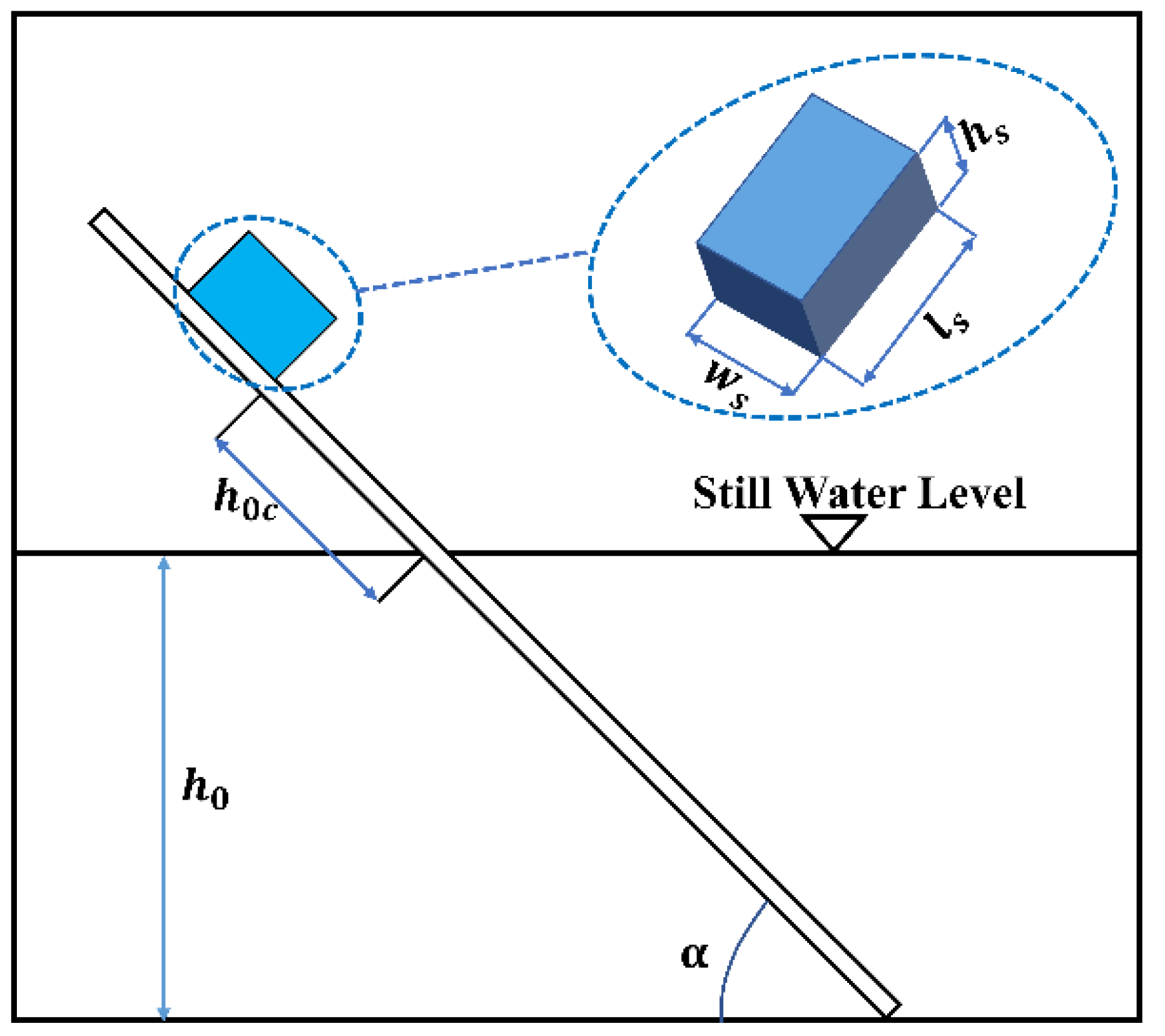
The experiment of Ataie-Ashtiani and Najafi-Jilani [
5] was conducted in a wave tank. The tank is 2.5 m wide, 1.8 m deep, and 25 m long and has two inclined planes with adjustable slope from 15° to 60° used for slide masses sliding into water. The wave tank has a flat section representing the main body of a reservoir. The sliding surface of the inclined planes is lubricated and can provide a frictionless slope. In the numerical simulation, the friction coefficient of the sliding surface is set to 0.001, considering that no completely smooth surface is found in the practical project. The sliding mass on the inclined planes collapses into water to simulate the impulse surge triggered by a landslide, and eight different pressure transducers are used as wave gages in the tank, in which wave gauge ST1 records the water surface fluctuation in near-field area by measuring the time series and water gauge ST2 to ST8 record water surface fluctuations in far-field areas. The details of the experiment set up can be seen in
Figure 1.
In the experiment of Ataie-Ashtiani and Najafi-Jilani, Case 76 (R-B2a-45-12) was chosen to perform model validation with Flow3D software. The schematics of sliding mass and landslide place are shown in
Figure 1, where the distance between the initial position of slide and water surface is
, still water depth is
, and the sliding angle of the inclined plane is represented by
. These correlation parameters of Case 76 are shown in
Table 1. The numerical simulation of Case 76 by Flow3D software is conducted, where a total of 9,000,000 cells are used, and the total calculating time is 3 s.
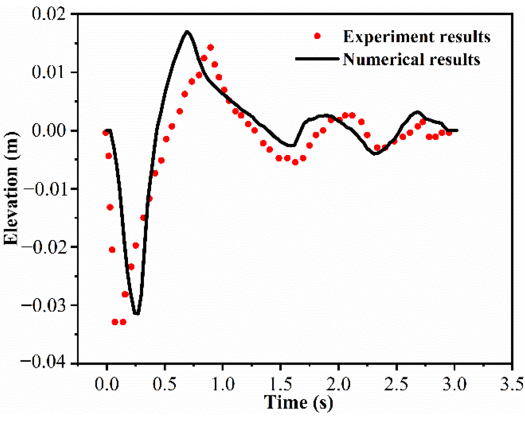
The recorded time series of case 76 measured by wave gauge ST1, which can be used to recognize water surface fluctuation and a general feature of impulse waves in near-field areas are chosen as the experimental data to validate the calculated model and the water surface fluctuation and wave features of Case 76 in the sliding zone of the near-field area are obtained by the calculated model of Flow3D software to make a comparison with the data of Case 76 as obtained by experiment.
Figure 2 shows the comparison of water surface fluctuation in the near-field area of Case 76, between the experimental data and the numerical calculation by Flow3D software, where zero elevation corresponds to still water level. The two results obtained by different methods have minor differences and show good consistency. The first wave trough with great peak amplitude of the two results all occurs at the point corresponding to the sliding center, which accords with the basic characteristics of underwater landslide-generated waves in near-field areas [
5,
21,
37,
38,
39]. In the numerical results, the variation of free water level after the first water trough accords with the fluctuation trend of the actual water body that has a small fluctuation and then gradually becomes calm. Therefore, on the basis of the experimental data validation, the numerical calculation by Flow3D software based on TruVOF method shows great accuracy and feasibility and can be used to simulate and calculate the impulse waves generated by landslides.
2.3. Model Settling
This study focuses on the influence of river channel characteristics on the propagation of landslide-generated waves and the dynamic water pressure acting on the dam surface. The main influencing factors on energy consumption of landslide-generated impulse waves in the propagation are the propagation path, water depth and the condition of channel bottom [
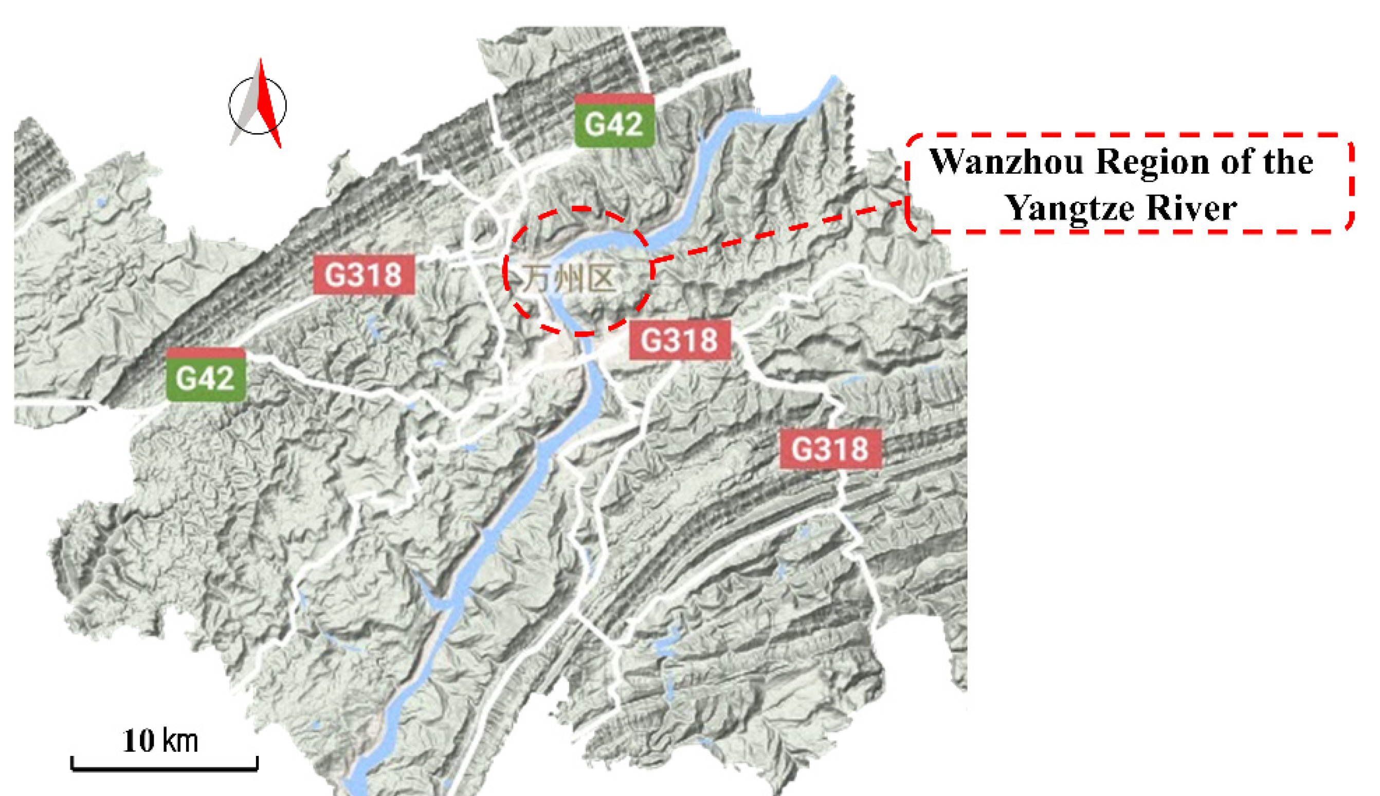
5]. In the practical river channel projects, river channels are curved, and some river channels with an extremely large bending angle may play a role in the propagation of landslide-generated waves and their energy transfer. As shown in
Figure 3, a curved river channel with approximately 90° river bending angle is found in Wanzhou part of the Yangtze River in the Three Gorges reservoir area. Therefore, water depth, channel width, and bending angle of river channel are chosen as the influencing factors, and their effects on the propagation of landslide-generated waves and dynamic water pressure on dam are investigated.
Table 2 shows the values of river channel characteristic parameters. Variable control method is introduced to investigate the effect of each single factor on wave propagation and dynamic water pressure on the dam.
Based on its physical form, landslide body can be divided into loose accumulation body and large rock landslide in the existing research. During the sliding process, the loose accumulation body deforms due to the effect of inertia and external force and thus there are long-term and complex interactions between sliding mass and water body, which leads to complicated wave generation. Experimental studies indicate that slide shape has a minor effect on landslide-generated wave characteristics [
5,
10]. In this study, the landslide body is defined as a rigid sliding block without considering its mass distribution. The slide shape is simplified to cuboid. The size of slide mass and some correlation parameters of landslide place are shown in
Table 1, where the velocity of water entry is represented by
, and other correlation parameters are depicted in
Figure 1.
The computational domain with Newtonian fluid is 150 m long, 80 m wide, 20 m deep and the water depth is 10 m. Uniform rectangular meshes are adopted for mesh division and the total number of meshes is 2,432,000. Landslides give rise to huge turbulence and deformation of the water surface. RNG k-ε turbulence model is adopted to simulate surge propagation due to its accuracy of simulating streamline flexure. The boundary condition of solid–fluid interface is set to wall without displacement boundary (Wall). The water body contacts the sliding surface of the reservoir bottom, but there is no fluid penetration or movement. The free surface boundary condition is applied for fluid surface. The pressure is set to a standard atmospheric pressure and the initial normal velocity of the free surface is 0.
3. Numerical Results
3.1. Influence of River Channel Characteristics on Wave Propagation
The propagation of landslide-generated impulse waves is influenced by channel characteristics greatly. In this part, the effect of channel characteristics, including water depth, water surface width and river bending angle on wave propagation is investigated through the analysis of numerical results obtained from numerical simulation. The maximum wave height, the fluctuation of free water level, and the variation of wave height at different locations are the important evaluation indices to describe the propagation of landslide-generated waves.
3.1.1. Influence of Water Depth
Figure 4 shows that change in free water surface at the cross section of water entry in different water depths. Still water depth is set to 8, 10, 12 and 14 m, and other correlative parameters remain unchanged. A wave-like water tongue is generated when the landslide surge propagates to the opposite bank. The surge with maximum initial wave height occurs near the water entry point of landslide at
t = 0.69 s, and the maximum wave amplitude above the still water is approximately 2.4, 1.85, 1.65 and 1.6 when water depth is 8, 10, 12 and 14 m, respectively. The wave with 8 m water depth reaches the opposite bank first, and its climbing height on the opposite bank is the largest. The wave with 14 m water depth has the largest climbing height on the sliding bank due to regurgitation.
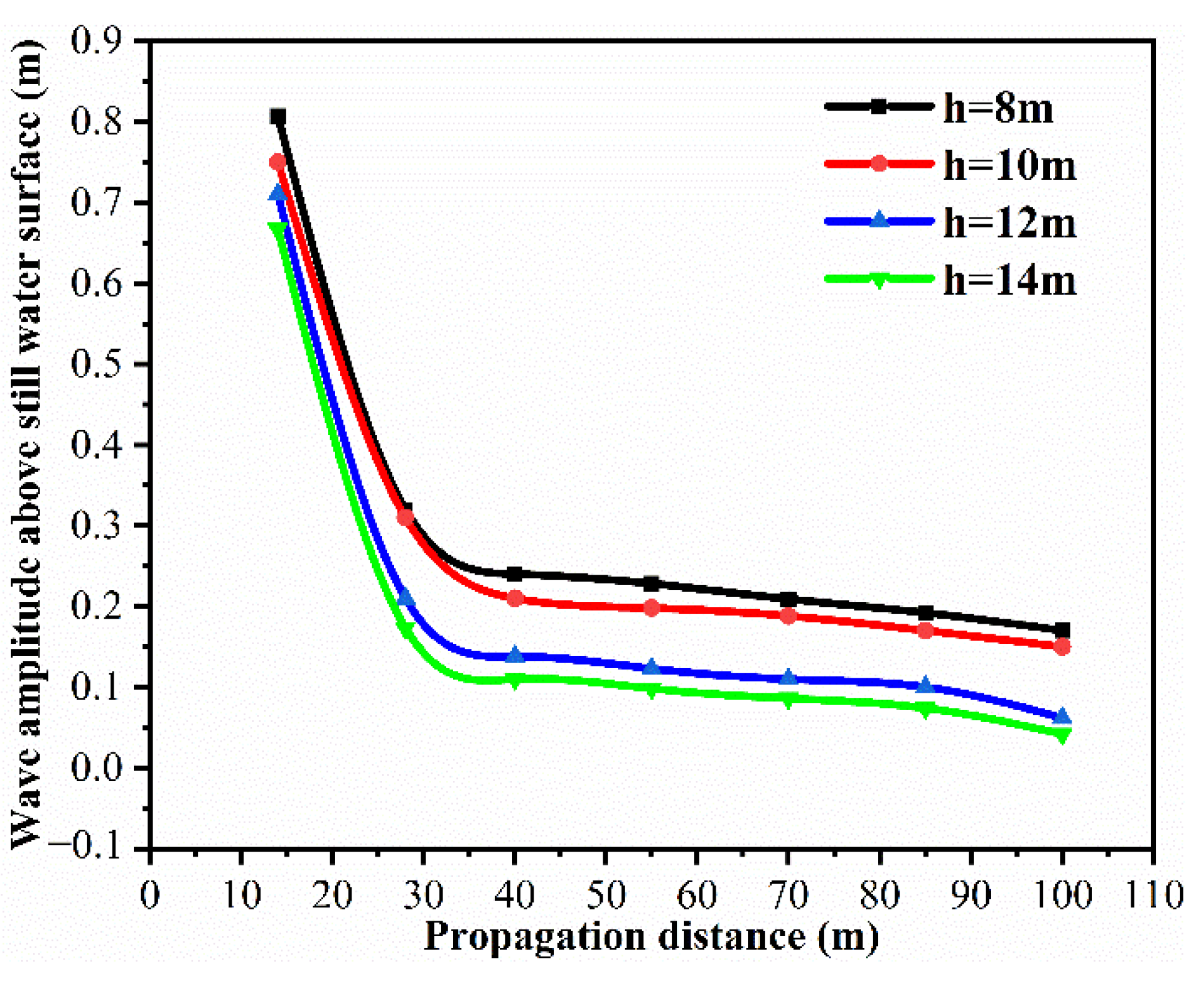
From
Figure 5, the wave amplitude above still water surface with the same propagation distance shows a decreasing tendency with the increase in water depth. The maximum wave amplitude above still water level in 8 m water depth is the largest and exceeds approximately 0.8 m. Wave amplitude decreases with the increase in propagation distance. The amplitude decreases sharply with the propagation distance increasing in the near-field area.
3.1.2. Influence of Water Surface Width
The wave height variation of impulse waves with different widths of water level at different observation places is shown in
Figure 6, where
B(
m) is the width of water surface and the distance between the observation place, and the landslide place is represented by
S(
m). In the near field with the distance of 14 m, the maximum wave height is approximately 10.9 m, which occurs on the first wave peak. The maximum wave height of surges with different river widths appears to be extremely close and all occurs on the first wave peak. The wave propagation of early phase with different widths of water level shows minimal difference in the near-field area. In the observation place with the distance of 70 m, the maximum wave height still occurs on the first wave peak but its value shows a difference where the maximum wave height is negatively correlated with the width of water surface. However, the observation place with distance of 100 m shows a completely different result where the maximum wave height occurs on the second wave peak. The height of the second wave peak, with 21 m water width, is over 10.3 m, and the height with 27 m water width is approximately 10.15 m. The value of the second wave peak height declines with the increase in the width of water surface and there is time advance of the second wave peak’s occurrence.
3.1.3. Influence of River Bending Angle
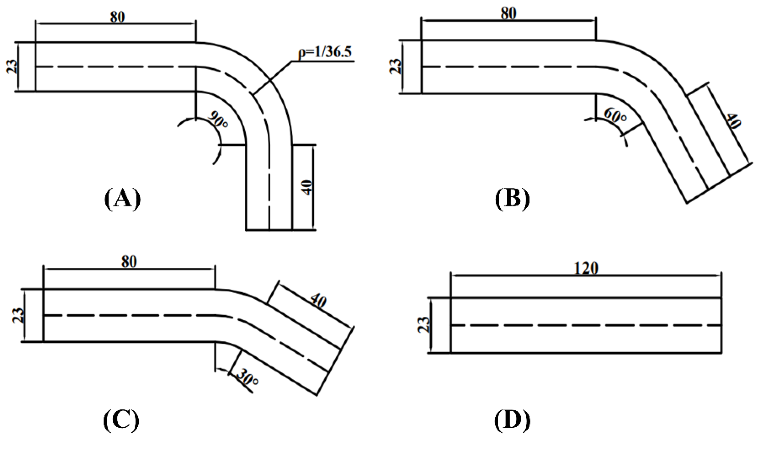
In the simulation, the bending angle of the river channel is set to 90°, 120°, 150° and 180°. The plane curvature of convex bank is set to 1/25, the curvature of the concave bank is 1/48, and the curvature of central line of the channel is 1/36.5. The channel width is 23 m, and the distance between the entry of the curved part and landslide place is set to 20 m. The schematics of these river channels are shown in
Figure 7.
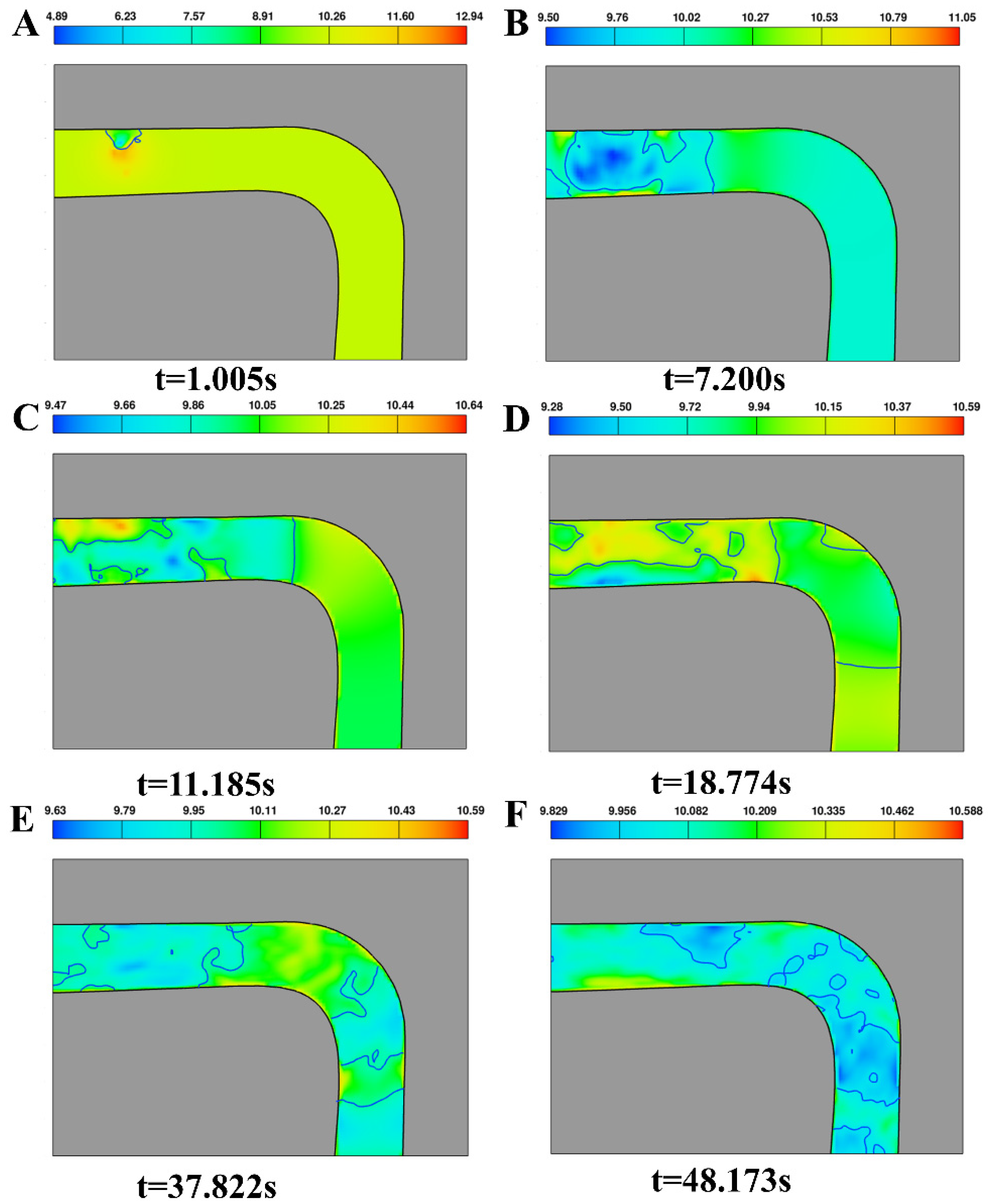
Figure 8 shows the propagation characteristics of landslide-generated waves in the channel with 90° bending angle. Apparently, the surge wave spread around the water entry point as the point of the circle at the beginning of surge propagation. At
t = 1.005 s, the maximum initial wave height appears, which is also the maximum wave height of the whole surge propagation. At
t = 7.200 s, the surge wave reaches and climbs the opposite bank, and then the surge wave falls into the river channel under gravity, which generates some waves near the opposite bank area. At
t = 11.185 s, the surge wave propagates to the curved part of river channel, and small-scaled waves are generated on the convex and concave parts of the river bank behind the surge wave. With the increase in propagation distance, these small-scaled waves on the concave bank still exist, but those on the convex bank disappear at
t = 18.774 s. At
t = 37.822 s, the first wave left the curved part of the channel, accompanied by some secondary waves, propagates forward along the axis of the channel. When these secondary waves propagate to the curved part, the variation of their wave height becomes complex and irregular. The variation amplitude of surge height decreases and then water surface becomes calm along with time.
As shown in
Figure 9A, in the channel with 90° bending angle, the maximum wave height is approximately 0.9 m at
t = 1.2 s, and the peak value of water trough height occurs at
t = 3.6 s. After
t = 10.81 s, the surge propagates to the curved part, and the variation of surge height becomes complex. With the progress of time, the wave amplitude above still water surface declines, and water surface becomes calm. The channels with 120° and 150° bending angles have a similar trend as the channel with the 90° bending angle, where the wave peak and wave trough all occur in the early phase and the wave height has different degrees of attenuation with the increase in propagation distance. Although the wave amplitude above still water surface attenuates after propagating to the curved part of river channel, the wave height in the channel with the 90° bending angle shows a stronger decline when propagating across the curved part.
3.2. Distribution of Dynamic Water Pressure on Dam Surface
3.2.1. Influence of Distance between Dam Site and Landslide Location
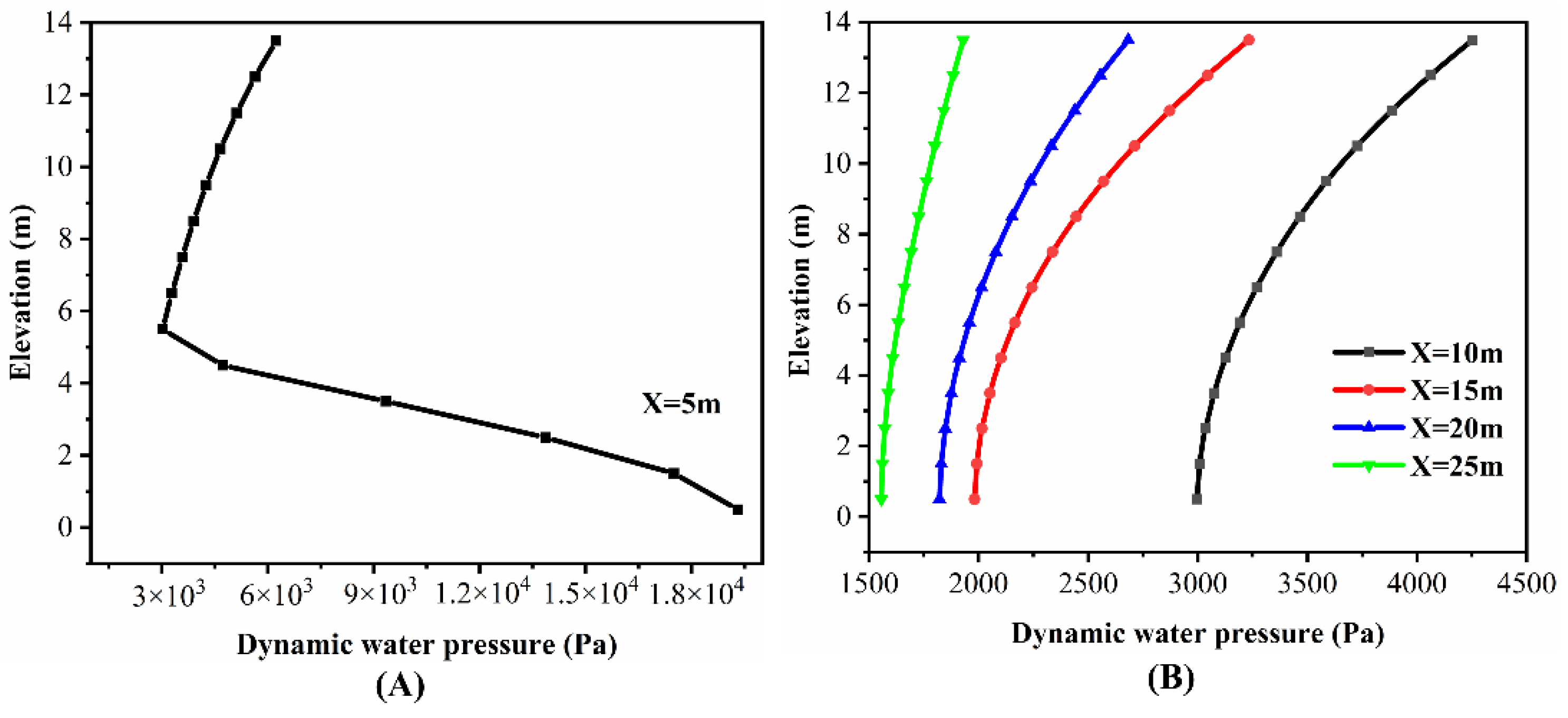
The distribution of dynamic water pressure by elevation is shown in
Figure 10, where the distance between dam site and landslide location is represented by
X(
m). The dynamic pressure distribution by elevation varies greatly due to the distance between dam site and the location of the landslide. The pressure distribution of the upper part of the dam is completely different from that in the lower part of the dam with the distance of 5 m. When the elevation exceeds 5 m, dynamic pressure increases with the increase in elevation, whereas the pressure distribution below 5 m elevation shows the completely opposite trend. The minimum of dynamic pressure is approximately 3000 Pa. However, when the distance between dam site and landslide location reaches and exceeds 10 m, the dynamic water pressure on dam is positively correlated with the elevation. At the same elevation, dynamic pressure obviously shows a decreasing tendency with the increase in distance between dam site and the location of the landslide.
3.2.2. Influence of Water Depth and Width of Water Surface
From
Figure 11A, water depth has a minor effect on the distribution of dynamic pressure, where the dynamic pressure increases with the increase in elevation. The variation amplitude of the pressure decreases with the increase in water depth. On the lowest part of the dam, the dynamic pressure of different depths shows minimal difference. The dynamic pressure of the water surface shows an increasing trend with the increase in water depth. The distribution of dynamic pressure by elevation is barely influenced by the width of the water surface. At the same elevation, the dynamic water pressure on the dam decreases with the increase in water surface width.
3.2.3. Influence of River Bending Angle
Figure 11C shows that the river bending angle has minimal effect on the distribution of dynamic pressure by elevation. Dynamic pressure increases with the increase in elevation. However, at the same elevation, river bending angle has an inhibitory effect on dynamic pressure. The dynamic pressure of the lowest part of dam is approximately 3000 Pa in straight channel, and the value in the channel with the 90° bending angle is less than 1700 Pa. The dynamic pressure shows an approximate vertical distribution by elevation with the increase in river bending angle.
4. Discussion
4.1. Effect Mechanism of Channel Characteristics on Wave Propagation
The propagation of landslide surge is shown as a circular-arc spread with the place of water entry as the center of the circle when channel characteristics are ignored. However, in the actual landslide-generated impulse waves, the conversion and attenuation of energy carried by the waves have a certain randomness. The change in surge wave form becomes irregular and stochastic with time and increase in the propagation distance The propagation of landslide surge is mass movement and energy transfer. Landslide mass slides into water and impacts the water surface due to bank slope instability, which triggers the turbulence of the water body and the impulse waves carried by the energy propagating forward.
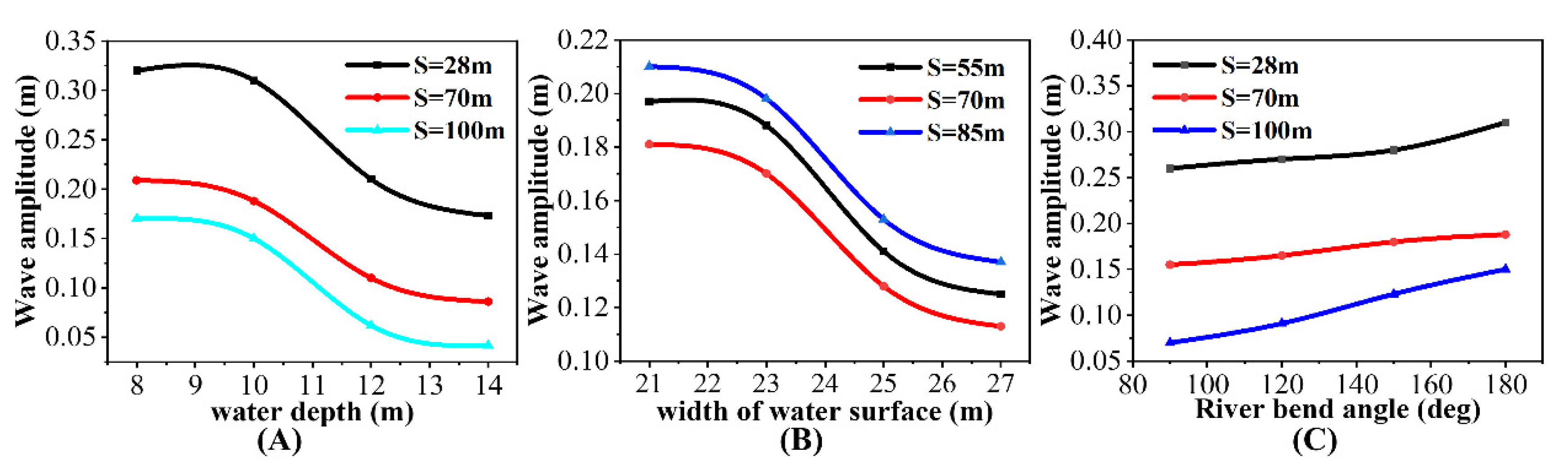
In
Figure 12A, the wave amplitude above the still water level with a 14 m water depth decreases by 45.9% compared with the wave with an 8 m water depth in the observation place, which is 28 m away from the location of the landslide. This finding indicates that water depth may have inhibitory effects on the energy conversion between sliding block and water. Sliding blocks are affected by the viscous force generated by water during the entire sliding process and the deeper the sliding depth, the longer the viscous force is exerted on the sliding blocks.
Figure 4 shows that the climbing wave height on the sliding bank has a positive correlation between the climbing height and the water depth. The cavity generated by block sliding in the deep water setting is larger than that in the shallow water setting. This condition may cause the surge to propagate to the sliding bank more violently in the deep water setting.
At the beginning of wave propagation, the wave does not propagate to the opposite bank. Therefore, when other relevant parameters are consistent, the characteristics of the initial wave propagation are barely influenced by the width of the water level, which can be demonstrated in
Figure 6. With the increase in the water level width, more energy is consumed because of the interaction with the bank and wave regurgitation when the waves propagate to the bank.
Figure 12B shows the same trend that the wave amplitude in propagation decreases with the increase in water surface width. The superposition with the later waves may cause the maximum value of the wave peaks and change their occurrence time. With the increase in propagation distance, the wave characteristics of the near-field area become complex and irregular due to the complex interactions.
River bending angle plays a positive role in the reduction of the surge height and attenuation of energy carried by the surge. As shown in
Figure 12, the 90° river channel has the most obvious effect on the reduction of propagation wave height. In the observation place, which is 28 m away from the location of the landslide, the wave height in the 90° channel decreases by 19.2% compared with the height in the straight channel. Different degrees of attenuation are obtained by surge height and energy due to the collision and extrusion of the water body with the bank when the surge propagates across the curved channel. In this process, different levels of wave peaks and troughs are observed because of the wave regurgitation and the superposition of the later waves. This effect has two sides, namely supplementing the surge wave and squeezing and impacting the surge water body, which reduces some of the energy of the surge wave. Therefore, the surge height increases or decreases continuously within a certain range and is complicated by the bending angle of the river channel.
4.2. Prediction Model for Propagation Wave Height
The empirical equations were proposed by analyzing the calculated results from numerical simulation. These equations can be applied to calculate and predict the propagation height of landslide surges with complex river channel characteristics considered. The dimensionless analysis method was exploited to group the relevant variables and construct a series of new fundamental dimensionless parameters. Using these dimensionless parameters, the propagation wave amplitude above the still water level
(m) can be expressed as follows:
where
(m) is the propagation wave amplitude of landslide surge,
(m) is the maximum wave amplitude of the surge,
h(m) is the still water depth,
x(m) is the propagation distance of the surge and
(deg) is the bending angle of the river channel. The undetermined values and functions were derived through multiple nonlinear regression analysis. Therefore, the fitting formula adopted to predict the propagation wave amplitude above the still water level can be depicted as follows:
The prediction model can be used to predict the landslide propagation wave height of a certain location in the curved channel when considering the river bending angle, where the value range of river bending angle is 90°to 180°.
Figure 13 shows the comparison between the formula values and numerical calculated values of the propagation wave amplitude, verifying the accuracy of Equation (2). It shows a great fitting degree for the formula value and the numerical calculated value.
4.3. Effect Mechanism of Wave Characteristics on the Distribution of Dynamic Pressure
The distribution of dynamic water pressure on the dam by elevation shows great differences due to the variation in distance between the dam site and the place where landslide occurs. When the distance is 5 m, the distribution of dynamic water pressure on the lower part of the dam is completely different from that on the upper part of dam. The energy carried by the sliding mass generated by the bank slope instability does not transfer toward the dam surface due to shorter distance between the dam site and the location of the landslide, and most of it may be taken to the lower part of the channel by the sliding mass, thereby posing strong disturbances and extrusion to the water body of the bottom of the river channel. This condition increases the dynamic pressure on the lower part of dam with the increase in water depth.
However, with the increase in distance, the dynamic pressure distribution on the dam by elevation increases with the increase in elevation and is barely influenced by the distance. At this moment, the water body of the upper part has stronger turbulence than the lower part. More energy carried by the waves is consumed because of the increase in propagation distance. Therefore, at the same elevation, the dynamic pressure declines with the increase in the distance between the dam site and landslide location.
The water depth and width of the water surface have a minor effect on the distribution of dynamic pressure on the dam by elevation. With the increase in water depth, the water body of the lower part has stronger turbulence, thereby increasing the dynamic pressure on the lower part. In
Figure 14B, the dynamic pressure in the channel with a 27 m water surface width decreases by 19.9% compared with the pressure in the channel with a 21 m channel width. With the increase in water level width, more interactions occur between the waves in different sequences due to wave regurgitation, and the effect of the river bank is obvious.
From
Figure 14A, the river bending angle plays a positive role in energy attenuation. When passing through the bend section, the surge collides and interacts with the river bank, and the energy experiences different degrees of attenuation. With the increase in the river bending angle, more intense interactions occur between the waves and river bank, more wave regurgitation exists in the river channel and more of the energy carried by the impulse waves is consumed. In this process, the propagation direction of the surge changes, and the heading up of the water surface emerges on the convex and concave bank. Therefore, the safety of lives and vessels on the curved part of the river channel should be prioritized.
5. Limitations and Future Works
Impulse waves induced by landslides occurring in the reservoir areas pose a great threat to the safety of river navigation, structural safety and the stable operation of hydraulic projects. In fact, the characteristics of landslide-generated waves vary depending on where landslides occur and the river channel characteristics. Simple flume experiments or numerical studies cannot lead to conclusions of general applicability. In this study, characteristics of landslide-generated impulse waves under the influence of river channel characteristics were investigated. Limitations and future work are as follows.
Landslide-generated impulse waves actually pass through both straight parts and curved parts with different bending angles when propagating in the river channel. This paper only considered the effect of one curved channel part with a specific bending angle on landslide wave propagation. Therefore, the complexity of the river channel can be taken into account further according the actual condition of the river channel when investigating the propagation of landslide-induced waves.
There may be multiple sliding points when landslide hazards occur. The propagation of impulse waves triggered by landslides with multiple sliding points can be further studied.
Numerical calculation requires greater precision due to the large scale of landslides and the complex interaction between the sliding body and surrounding environment. Considering the interaction between the sliding body and the mountains on both sides of the river and other factors affecting the development of landslide waves, secondary development of numerical software is needed for more precise calculations.
6. Conclusions
In this study, the numerical method was used to investigate the propagation characteristics of landslide-generated impulse waves and the distribution of dynamic water pressure acting on the dam surface by considering the river characteristics. The hazard of landslide surges is mainly manifested in the strong turbulence of the water body caused by the landslides sliding into the water. River characteristics exert great influence on the propagation of landslide-generated waves and the dynamic water pressure triggered by the water turbulence. Therefore, the influence of the river channel characteristics on landslide-generated wave propagation is highlighted in this study. The main conclusions in this study are summarized as follows:
Water depth exerts an inhibitory effect on wave amplitude in propagation and plays a positive role in energy attenuation. The maximum amplitude of the initial wave shows a negative correlation with water depth.
The width of the water surface mainly exerts influence on wave propagation in the far-field area. The width variation influences the maximum value and the occurrence times of wave peaks and complicates the propagation characteristics of waves.
River channel curvature shows a negative relationship with the surge height. It plays a positive role in the energy attenuation of the landslide surge. The larger the river channel curvature, the greater the attenuation rate of the energy carried by the landslide surge. The surge height in propagation is under the common influence between the water depth and the bending angle of the river channel.
A prediction model considering complex river channel characteristics is presented and can be used to calculate propagation wave height and analyze the propagation characteristics of landslide-generated waves.
The distribution of dynamic water pressure by elevation is mainly influenced by the distance between dam site and the location of the landslide but barely influenced by the river channel characteristics. When the distance is close, the distribution of upper and lower dam surfaces is opposite and the dynamic pressure has a negative correlation with elevation in the lower part, but the distribution with larger distances shows the reverse trend. The width of the water surface and river bending angle exert inhibitory effects on the value of the dynamic pressure.
Author Contributions
Project administration, funding acquisition, X.Z.; Writing—original draft, review and editing, N.S.; conceptualization, resources, X.L. (Xiaochun Lu); formal analysis, B.X.; data curation, H.M.; methodology, Z.C.; investigation, X.L. (Xiao Liu). All authors have read and agreed to the published version of the manuscript.
Funding
This work was supported by the National Natural Science Foundation of China (U2240221).
Data Availability Statement
The original contributions presented in the study are included in the article; further inquiries can be directed to the corresponding author.
Conflicts of Interest
The authors declare no conflict of interest.
References
- Panizzo, A.; De Girolamo, P.; Di Risio, M.; Maistri, A.; Petaccia, A. Great Landslide Events in Italian Artificial Reservoirs. Nat. Hazards Earth Syst. Sci. 2005, 5, 733–740. [Google Scholar] [CrossRef] [Green Version]
- Zaniboni, F.; Tinti, S. The 1963 Vajont Landslide: A Numerical Investigation on the Sliding Surface Heterogeneity. Pure Appl. Geophys. 2019, 176, 279–295. [Google Scholar] [CrossRef]
- Tan, H.; Chen, S. A Hybrid DEM-SPH Model for Deformable Landslide and Its Generated Surge Waves. Adv. Water Resour. 2017, 108, 256–276. [Google Scholar] [CrossRef]
- Watts, P. Water Waves Generated by Underwater Landslides; California Institute of Technology: Pasadena, CA, USA, 1997. [Google Scholar]
- Ataie-Ashtiani, B.; Najafi-Jilani, A. Laboratory Investigations on Impulsive Waves Caused by Underwater Landslide. Coast. Eng. 2008, 55, 989–1004. [Google Scholar] [CrossRef]
- Fritz, H.M.; Hager, W.H.; Minor, H.E. Landslide Generated Impulse Waves. Exp. Fluids 2003, 35, 505–519. [Google Scholar] [CrossRef]
- Meng, Z. Experimental Study on Impulse Waves Generated by a Viscoplastic Material at Laboratory Scale. Landslides 2018, 15, 1173–1182. [Google Scholar] [CrossRef]
- Mohammed, F.; Fritz, H.M. Experiments on Tsunamis Generated by 3D Granular Landslides. In Submarine Mass Movements and Their Consequences; Springer: Dordrecht, The Netherlands, 2010. [Google Scholar]
- Panizzo, A.; De Girolamo, P.; Petaccia, A. Forecasting Impulse Waves Generated by Subaerial Landslides. J. Geophys. Res. Ocean. 2005, 110, 1–23. [Google Scholar] [CrossRef]
- Ataie-Ashtiani, B.; Nik-Khah, A. Impulsive Waves Caused by Subaerial Landslides. Environ. Fluid Mech. 2008, 8, 263–280. [Google Scholar] [CrossRef]
- Noda, E. Water Waves Generated by Landslides. ASCE Waterw. 1970, 96, 835–855. [Google Scholar] [CrossRef]
- Walder, J.S.; Sorensen, O.E.; Watts, P. Water Waves Generated by Subaerial Mass Flows. In AGU Fall Meeting Abstracts; American Geophysical Union: Washington, DC, USA, 2001; Volume 2001, p. H22G-02. [Google Scholar]
- Zweifel, A.; Hager, W.H.; Minor, H.E. Plane Impulse Waves in Reservoirs. J. Waterw. Port Coast. Ocean Eng. 2006, 132, 358–368. [Google Scholar] [CrossRef]
- Heller, V. Landslide Generated Impulse Waves: Prediction of near Field Characteristics. Ph.D. Thesis, ETH Zurich, Zürich, Switzerland, 2007. [Google Scholar]
- Viroulet, S.; Sauret, A.; Kimmoun, O. Tsunami Generated by a Granular Collapse down a Rough Inclined Plane. EPL Europhys. Lett. 2014, 105, 3. [Google Scholar] [CrossRef] [Green Version]
- Huang, B.; Yin, Y.; Chen, X.; Liu, G.; Wang, S.; Jiang, Z. Experimental Modeling of Tsunamis Generated by Subaerial Landslides: Two Case Studies of the Three Gorges Reservoir, China. Environ. Earth Sci. 2014, 71, 3813–3825. [Google Scholar]
- Heinrich, P. Nonlinear Water Waves Generated by Submarine and Aerial Landslides. J. Waterw. Port Coast. Ocean Eng. 1992, 118, 249–266. [Google Scholar] [CrossRef]
- Abadie, S.; Morichon, D.; Grilli, S.; Glockner, S. Numerical Simulation of Waves Generated by Landslides Using a Multiple-Fluid Navier–Stokes Model—ScienceDirect. Coast. Eng. 2010, 57, 779–794. [Google Scholar] [CrossRef]
- Grilli, S.T.; Asce, M.; Watts, P. Tsunami Generation by Submarine Mass Failure. I: Modeling, Experimental Validation, and Sensitivity Analyses. J. Waterw. Port Coast. Ocean. Eng. 2005, 131, 283–297. [Google Scholar] [CrossRef]
- Yuk, D.; Yim, S.; Liu, P. Numerical Modeling of Submarine Mass-Movement Generated Waves Using RANS Model. Comput. Geosci. 2006, 32, 927–935. [Google Scholar] [CrossRef]
- Ataie-Ashtiani, B.; Shobeyri, G. Numerical Simulation of Landslide Impulsive Waves by Incompressible Smoothed Particle Hydrodynamics. Int. J. Numer. Methods Fluids 2008, 56, 209–232. [Google Scholar] [CrossRef]
- Schwaiger, H.F.; Higman, B. Lagrangian Hydrocode Simulations of the 1958 Lituya Bay Tsunamigenic Rockslide. Geochem. Geophys. Geosyst. 2007, 8, Q07006. [Google Scholar] [CrossRef]
- Vacondio, R.; Mignosa, P.; Pagani, S. 3D SPH Numerical Simulation of the Wave Generated by the Vajont Rockslide. Adv. Water Resour. 2013, 59, 146–156. [Google Scholar] [CrossRef]
- Shi, C.; An, Y.; Wu, Q.; Liu, Q.; Cao, Z. Numerical Simulation of Landslide-Generated Waves Using a Soil–Water Coupling Smoothed Particle Hydrodynamics Model. Adv. Water Resour. 2016, 92, 130–141. [Google Scholar] [CrossRef] [Green Version]
- Wang, W.; Chen, G.Q.; Hong, Z.; Zhou, S.H.; Liu, S.G.; Wu, Y.Q.; Fan, F.S. Analysis of Landslide-Generated Impulsive Waves Using a Coupled DDA-SPH Method. Eng. Anal. Bound. Elem. 2016, 64, 267–277. [Google Scholar] [CrossRef]
- Chen, C. Destabilizing Mechanism Analysis and Stability Evaluation of a Large Accumulation Bank Slope at an Alpine George Reservoir; Chengdu University of Technology: Chengdu, China, 2011. [Google Scholar]
- Huang, B.L.; Yin, Y.P.; Wang, S.C.; Tan, J.M.; Chen, X.T.; Liu, G.N. Analysis of Landslide Generated Impulse Waves; Science Press: Beijing, China, 2019. [Google Scholar]
- Risio, M.D.; Bellotti, G.; Panizzo, A.; Girolamo, P.D. Three-Dimensional Experiments on Landslide Generated Waves at a Sloping Coast. Coast. Eng. 2009, 56, 659–671. [Google Scholar] [CrossRef]
- Gingold, R.A.; Monaghan, J.J. Smoothed Particle Hydrodynamics: Theory and Application to Non-Spherical Stars. Mon. Not. R. Astron. Soc. 1977, 181, 375–389. [Google Scholar] [CrossRef]
- Gomez-Gesteira, M.; Rogers, B.D.; Dalrymple, R.A.; Crespo, A.J.C. State-of-the-Art of Classical SPH for Free-Surface Flows. J. Hydraul. Res. 2010, 48, 6–27. [Google Scholar] [CrossRef]
- Monaghan, J.J. Simulating Free Surface Flows with SPH. J. Comput. Phys. 1994, 110, 399–406. [Google Scholar] [CrossRef]
- Dalrymple, R.A.; Rogers, B.D. Numerical Modeling of Water Waves with the SPH Method. Coast. Eng 2006, 53, 141–147. [Google Scholar] [CrossRef]
- Hirt, C.W.; Nichols, B.D. Volume of Fluid (VOF) Method for the Dynamics of Free Boundaries. J. Comput. Phys. 1981, 39, 201–225. [Google Scholar] [CrossRef]
- Bayon, A.; Toro, J.P.; Bombardelli, F.A.; Matos, J.; López-Jiménez, P.A. Influence of VOF Technique, Turbulence Model and Discretization Scheme on the Numerical Simulation of the Non-Aerated, Skimming Flow in Stepped Spillways. J. Hydro-Environ. Res. 2017, 19, 137–149. [Google Scholar] [CrossRef] [Green Version]
- Hager, W.H.; Giudice, G.D.; Wu, W.; Wang, S. Movable Bed Roughness in Alluvial Rivers. J. Hydraul. Eng. 2001, 127, 627–629. [Google Scholar] [CrossRef]
- Rodriguez, J.; Bombardelli, F.; García, M.; Frothingham, K.; Rhoads, B.; Abad, J. High-Resolution Numerical Simulation of Flow Through a Highly Sinuous River Reach. Water Resour. Manag. 2004, 18, 177–199. [Google Scholar] [CrossRef]
- Lynett, P.; Liu, L.F. A Numerical Study of Submarine-Landslide-Generated Waves and Run-Up. Proc. Math. Phys. Eng. Sci. 2002, 458, 2885–2910. [Google Scholar] [CrossRef]
- Grilli, S.T.; Watts, P. Tsunami Generation by Submarine Mass Failure. II: Predictive Equations and Case Studies. J. Waterw. Port Coast. Ocean Eng. 2005, 131, 298–310. [Google Scholar]
- Ataie-Ashtiani, B.; Najafi-Jilani, A. Prediction of Submerged Landslide Generated Waves in Dam Reservoirs: An Applied Approach. Dam Eng. 2006, 17, 135. [Google Scholar]
Figure 1.
Schematic of sliding mass and landslide place.
Figure 1.
Schematic of sliding mass and landslide place.
Figure 2.
Comparison of water surface fluctuation in near-field area of Case 76 between the experiment and numerical calculation.
Figure 2.
Comparison of water surface fluctuation in near-field area of Case 76 between the experiment and numerical calculation.
Figure 3.
Schematic of Wanzhou region of the Yangtze River.
Figure 3.
Schematic of Wanzhou region of the Yangtze River.
Figure 4.
Fluctuation of free water level at the crossed section in different water depths: (A) t = 0.69 s; (B) t = 2.72 s.
Figure 4.
Fluctuation of free water level at the crossed section in different water depths: (A) t = 0.69 s; (B) t = 2.72 s.
Figure 5.
Variation of wave amplitude above still water level with propagation distance in different water depths.
Figure 5.
Variation of wave amplitude above still water level with propagation distance in different water depths.
Figure 6.
Wave surface variation of different observation places in different widths of water level: (A) S = 14 m; (B) S = 70 m; (C) S = 100 m.
Figure 6.
Wave surface variation of different observation places in different widths of water level: (A) S = 14 m; (B) S = 70 m; (C) S = 100 m.
Figure 7.
Parameters of river channels; (A) 90° river channel; (B) 120° river channel; (C) 150° river channel; (D) 180° river channel.
Figure 7.
Parameters of river channels; (A) 90° river channel; (B) 120° river channel; (C) 150° river channel; (D) 180° river channel.
Figure 8.
Wave propagation characteristics at different times in 90° curved channel: (A) t = 1.005 s; (B) t = 7.200s; (C) t = 11.185 s; (D) t = 18.774 s; (E) t = 37.822 s; (F) t = 48.173 s.
Figure 8.
Wave propagation characteristics at different times in 90° curved channel: (A) t = 1.005 s; (B) t = 7.200s; (C) t = 11.185 s; (D) t = 18.774 s; (E) t = 37.822 s; (F) t = 48.173 s.
Figure 9.
Wave variation at different times in the curved channel with different bending angles.
Figure 9.
Wave variation at different times in the curved channel with different bending angles.
Figure 10.
Distribution of dynamic water pressure by elevation in different distances between dam site and landslide location: (A) X = 5 m; (B) X = 10, 15, 20, 25 m.
Figure 10.
Distribution of dynamic water pressure by elevation in different distances between dam site and landslide location: (A) X = 5 m; (B) X = 10, 15, 20, 25 m.
Figure 11.
Distribution of dynamic pressure by elevation at different water depths, widths of water level and river bend angles: (A) water depth; (B) width of water level; (C) bending angle of river channel.
Figure 11.
Distribution of dynamic pressure by elevation at different water depths, widths of water level and river bend angles: (A) water depth; (B) width of water level; (C) bending angle of river channel.
Figure 12.
Variation in wave amplitude with water depth, width of water surface and river bending angle: (A) water depth; (B) water surface width; (C) river bending angle.
Figure 12.
Variation in wave amplitude with water depth, width of water surface and river bending angle: (A) water depth; (B) water surface width; (C) river bending angle.
Figure 13.
Comparison between the numerical values and values derived by the prediction formula for propagation wave amplitude.
Figure 13.
Comparison between the numerical values and values derived by the prediction formula for propagation wave amplitude.
Figure 14.
Variation in dynamic pressure with channel width and river bending angle at different elevations; (A) width of river channel; (B) river bending angle.
Figure 14.
Variation in dynamic pressure with channel width and river bending angle at different elevations; (A) width of river channel; (B) river bending angle.
Table 1.
Specific parameters of landslide model.
Table 1.
Specific parameters of landslide model.
| Case | Slide Deformability | Slide Shape | (cm) | (cm) | (cm) | (cm) | (cm) | (deg) |
|---|
| Model for validation | Rigid | Cuboid | 30 | 20 | 13 | 50 | 2.5 | 45 |
| Model for simulation | Rigid | Cuboid | 900 | 750 | 300 | 1000 | 0 | 45 |
Table 2.
Value of river channel characteristic parameters.
Table 2.
Value of river channel characteristic parameters.
| Water Depth (m) | Water Surface Width (m) | River Bending Angle (deg) |
|---|
| 8 | 21 | 90 |
| 10 | 23 | 120 |
| 12 | 25 | 150 |
| 14 | 27 | 180 |
| Publisher’s Note: MDPI stays neutral with regard to jurisdictional claims in published maps and institutional affiliations. |
© 2022 by the authors. Licensee MDPI, Basel, Switzerland. This article is an open access article distributed under the terms and conditions of the Creative Commons Attribution (CC BY) license (https://creativecommons.org/licenses/by/4.0/).


