Article

Decision Making Methods to Optimize New Dam Site Selections on the Nitra River

1
Department of Water Resources and Environmental Engineering, Faculty of Horticulture and Landscape Engineering, Slovak University of Agriculture in Nitra, 949 76 Nitra, Slovakia
2
Vodohospodárska Výstavba š.p, 831 02 Bratislava, Slovakia
3
Department of Landscape Planning and Land Consolidation, Faculty of Horticulture and Landscape Engineering, Slovak University of Agriculture in Nitra, 949 76 Nitra, Slovakia
4
Department of Ecology and Environmental Sciences, Faculty of Natural Sciences, Constantine Philosopher University in Nitra, 949 74 Nitra, Slovakia
*
Author to whom correspondence should be addressed.
Water 2020, 12(7), 2042; https://doi.org/10.3390/w12072042
Submission received: 5 June 2020 / Revised: 5 July 2020 / Accepted: 16 July 2020 / Published: 18 July 2020
(This article belongs to the Special Issue Hydrological Impacts of Climate Change and Land Use)

Abstract

:
Grouping both existing and newly planned reservoirs based on selected measurable characteristics allows to point out issues that are relevant to area management using experience obtained from the environment of other sites. Divisive hierarchical clustering has been deployed to find similarities between dam locations. The Nitra River Basin (located in Nitra District, Nitra Region in Slovakia) with its 54 reservoirs is the model area. Profiles for 11 potential new reservoirs have been developed. Partial river basins were identified for each of the existing and new reservoirs using a digital relief model. The area size, proportion of arable land, forestland and built-up area, degree of exposure to soil erosion and the volume of surface runoff have been used as parameters for comparisons. Six clusters have been identified containing similar existing as well as new locations, one of them being a special case.

1. Introduction

Water has been a basic requirement for humanity from the very beginning, and it used to be drawn from natural resources such as springs, rivers and lakes. It was when humans began to settle in larger numbers in urban regions that they found themselves in need of constructing adequate water reserves. Another reason why dams and reservoirs started to be built was to protect against erosion, flooding and fire, as well as for recreation and fishing, and rivers were where the construction of dams and hydraulic construction started, with channel reservoirs, irrigation canals and dam reservoirs necessary for supplying water or hydro-energy to cities and towns. In [1] dams are defined as water-retaining obstacles used specially to accumulate surplus water as well as for managing and allocating water to particular regions. Reservoirs provide protection, redevelopment, seepage, reserves, retention, implementation, accumulation and clearing. Just et al. [2] commented that for a reservoir to fully function, it is crucial for it to meet these criteria of renewal and construction: (A) retaining flood discharge—the reservoir has a retention area, including appropriate functional objects; (B) improving of water quality, especially in case of flow-through reservoirs, which may favorably improve poorer-quality water and (C) support biodiversity. What is essential is their recreational, aesthetic and hygienic significance [3,4]. All of a country’s reservoirs fulfil certain major and many minor functions. These reservoirs contribute toward raising water quality in river basins and have a special indispensable significance in areas with narrow watercourses and a sparse hydrographic network, contributing considerably toward balancing water source capacity, water quality and everybody’s needs at any season or location [5,6].
In addition to a reservoir’s positive impact on the living and natural environment and on people [7,8], including provision of drinking water, there are also outcomes with a negative impact. For instance, polluted water may rapidly spread various infections and be a critical factor in epidemic outbreaks [9,10].
Jurík et al. [11] classify reservoirs into three groups. There are hydromelioration structures (necessary for managing ground water in soil and for water reproduction of plants and animals); hydrotechnical structures (solving the biggest and most crucial tasks related to major watercourses and considerable water reserves); health and water management structures (for water management in municipalities, towns and production units). Dams whose wall height is at least 150 m are categorized as “gigantic dams”, which are absent in the Slovak Republic. Four of Slovakia’s 231 dams reach the highest height of 15 m. Out of that number, Nitrianske Rudno (registered at ICOLD—International Commission on Large Dams), located in Prievidza District in Trenčín Region is a part of the Nitra river basin modeled. The other three reservoirs are located in Bratislava Region, Banská Bystrica Region and Trenčín Region. The others are small reservoirs (MVN) whose dam heights are less than 15 m, with 53 of them situated in the area to be modeled.
This paper focuses on small reservoirs. Jurík et al. [11] define small reservoirs as an artificially or naturally created space filled and drained with water depending on the season. This term may define reservoirs as designed to retain or accumulate water, maintaining a potential imbalance between water offtake from the reservoir and water inflow into it. Small reservoirs are an integral part of agriculture, significantly aiding in environmental protection [12] and providing protection against flooding, space for redevelopment, seepage, reserve, retention, implementation, accumulation and clearing. In rural areas, they are a significant factor that may restrict the occurrence of floods, soil erosion and other hydrological risks [13,14]. In terms of water management, they are divided into three types: reserve (accumulation) reservoirs, protection (retention) reservoirs and multi-purpose reservoirs. STN 73 68 24 (Technical standard-Small reservoirs) defines small reservoirs according to how they fulfill several requirements: A reservoir volume which reaches the surface of controllable space not bigger than 2 millions cubic meters, the greatest depth of the water in the reservoir does not exceed 9 m, and the hundred-year flow rate (Q100) in the dam profile is not bigger than 60 cubic meters per second, or in case of reservoirs into where water is drawn artificially, this value should not exceed Q100 of the reservoir’s river basin and inlet capacity.
Small reservoirs contribute toward improving water quality in river basins and have special indispensable significance in areas with narrow watercourses and a sparse hydrographic network, contributing considerably toward balancing water source capacity, water quality and everybody’s needs at any season or location [15,16]. In terms of its position on a water source, reservoirs are further classified into spring reservoirs, which are situated on the edge of the hydrographic network and supplied by the discharge from spring snow melt and heavy rainfalls. The dimensions of these reservoirs catch a substantial part of the entire inflow from major runoffs, heavy rainfall and spring melting.
Czechoslovakia’s National Water Management Plan (1956) highlighted the gradual construction of small reservoirs and polders in the Nitra River Basin to satisfy the needs of the country’s manufacturing plants and healthcare facilities, for social and cultural aspects, and to protect the surrounding area against the harmful effects of water. The construction schedule for new reservoirs set out rules to create a system that would allow for purposeful water management. This is also evident in the 26 reservoirs that had been constructed and commissioned by the end of the 1960′s. The number of new reservoirs had been slowly declining until the construction of the most recent dam and reservoir in Haláčovce, which opened in 1990 [17]. While proposals for new reservoirs have not disappeared from water management plans, there has been no dam and reservoir construction since 1998.
After roughly ten years, climatic changes started to emerge, of which global warming was the most profound, occurring in all locations and climatic areas around the world. In March 2019, Slovakia unveiled an action plan to address water scarcity and drought. Water is Valuable (in Slovak “H2O dnota je voda”) was approved in an effort to reduce exposure to water scarcity, drought and the impact on human health, economic activities, environment and cultural heritage [18]. An increase in average temperature reduces the harvest on farmland that is not irrigated [19]. Frequent and intensive heavy rainfall causes extreme phenomena to appear that accelerate soil degradation, negatively lowering the soil’s retention capacity [20]. As uneven rainfall over the year occurs ever more frequently, the resulting floods put property in danger, directly endangering human lives [21].
The issue of constructing new dams and reservoirs has recently come to the forefront, especially small reservoirs and polders which would cover for the lack of water during extreme weather conditions, either drought or heavy floods, with the water in the reservoir reserved for such situations.
Support for nationwide action in areas affected by river basin runoff and for improved water balance is global matter. According to Mosley [22], the impact of climatic drought on water abundance has become strongly pronounced and is pressing. Karásek et al. [23] describe the importance of building more reservoirs to protect soil and water, highlighting their precise location in a country with the aim of producing an optimal, versatile effect. The same authors see analyzing and assessing the use of river basin soil as necessary for river basin water source management and planning [24,25,26].
The identification of hydrologically homogeneous regions is usually the most crucial and challenging step in the regional analysis [27]. One of the methods commonly employed to regionalize catchment parameters is cluster analysis [28,29]. It is widely performed in classifying hydrological processes using various variables. For example, Li et al. [30] proposed the hierarchical clustering algorithm for the classification of basins and to determine homogeneous basins, while Lecce [31] uses a non-hierarchical clustering method for determining and clustering the spatial variations in seasonal flood characteristics. Kahya et al. [32] cluster in order to delineate geographical zones having similar monthly streamflow variations. For the identification of hydrologically homogeneous basins, Dikbas et al. [29] apply annual maximum river flows, a coefficient of variation and skewness of annual maximum river flows and geographical coordinates of latitude and longitude. Cupak, et al. [33] evaluate the possibility of using statistical methods for data agglomeration, such as cluster analysis for determining hydrologically homogeneous regions characterized by low flow and selected physiographic and meteorological features of the catchments.
This paper seeks to optimize new dams site selection using decision-making methods based on the classification of existing and planned reservoirs into clusters within the context of specified characteristics at various levels of similarity, with the aim of estimating adequate approaches toward the potential optimization of activities carried out on river basins and potentially new water structures.

2. Materials and Methods
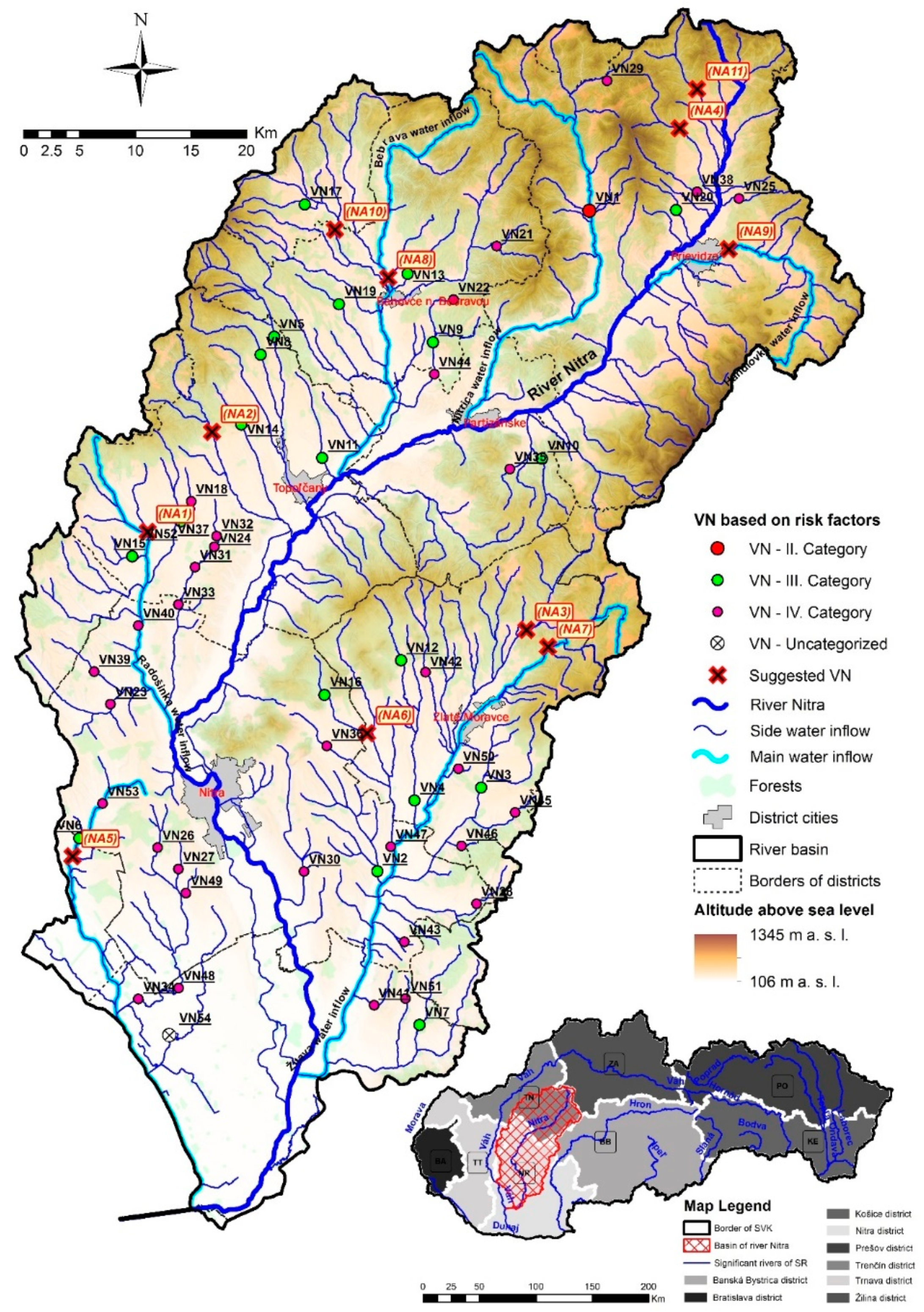
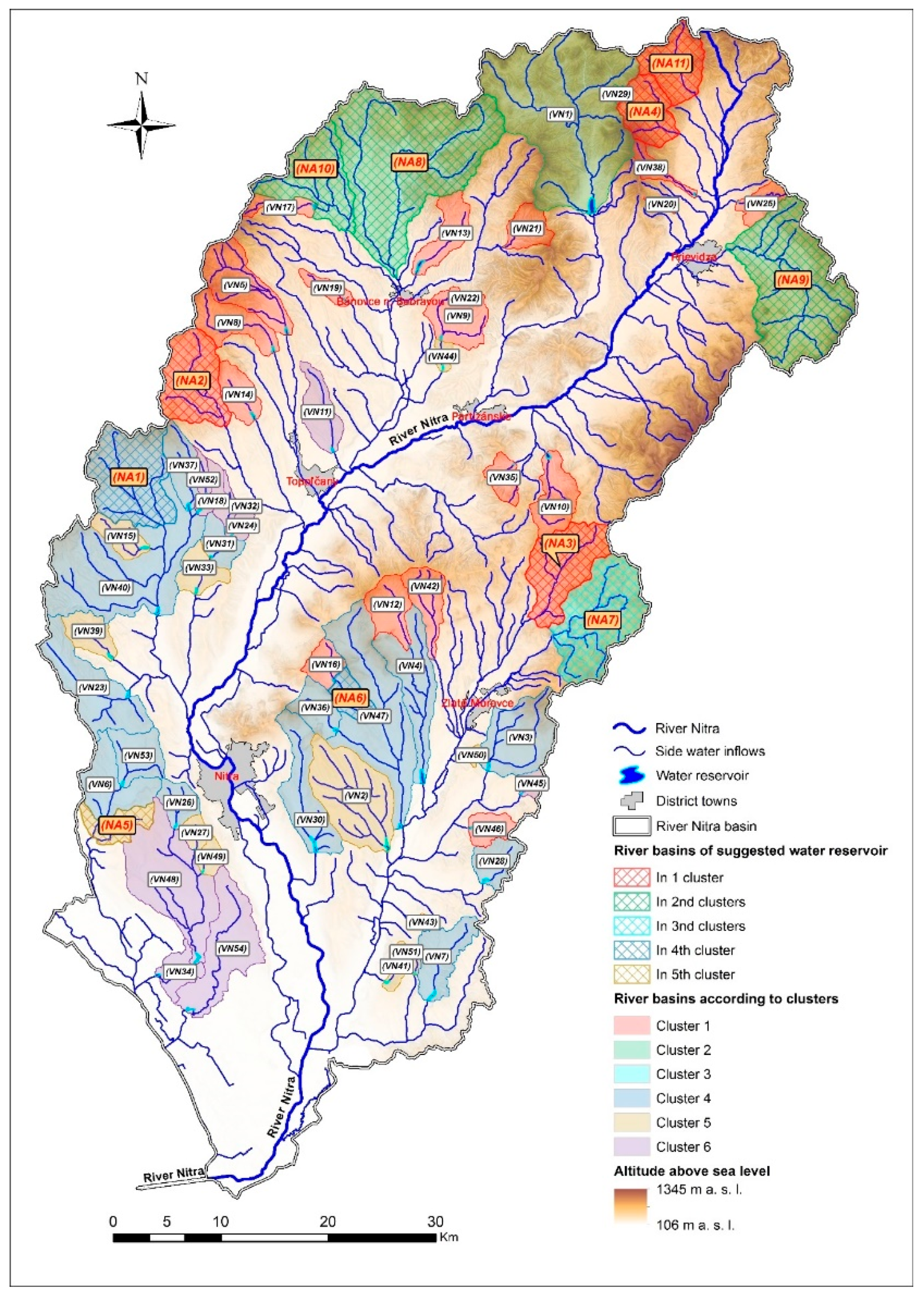
2.1. Case Study

The area to be modeled is the Nitra River Basin (Figure 1). The Nitra River itself is 169 km in length and situated in the western part of Slovakia. It is part of the southeastern Váh River watershed. The Nitra River Basin neighbors the river basins of the Turiec to the north-east, the Váh northwest of it, the Hron to the west, and the Danube to the south. The Nitra River Basin covers 376 cadastral districts, and the reservoirs researched were constructed on 69 of them. Its size is 4501 km2. The shape of the catchment area is longitudinal to fan-like with an average slope of 10.1°. The density of the river network is 1.29 km–2, and the forest cover is at the level of 54.1%. Deciduous forests occupy 41.2% of the catchment area. It falls into several climatic zones, from a dry area of the warm climatic zone to the humid to very humid hilly to highland area of the moderately warm climatic zone to the moderately cold and very humid area of the cold zone. The average annual total precipitation is around 800 mm. The area consists mainly of Neogene sediments, which are hydro-geologically impermeable, covered by alluvium of the Nitra River and its tributaries.
The watershed of the river network is comprised of its main tributaries. These are the Handlovka, Nitrica, Bebrava, Radošinka, Žitava and the man-made Dlhý Kanál (Long Canal). There are 54 reservoirs in the river basin that are being researched, of which 26 are operated by the Slovak Water Management Enterprise and others are privately owned by either individuals or organizations. Water reservoirs are divided according to risk factor categories (F) from highest to lowest, II–IV, (Table 1), which are given by the sum of all direct and consequential losses, including human lives that would occur in the event of failure of a structure that retains water at full swelling in the reservoir. The magnitude of the potential danger depends on the population density, the economic and industrial development in the area affected by the water structure and its economic importance in points (no reservoir is in risk category I. in the river basin). The point evaluation of the risk factor in individual categories is given in Decree no. 119/2016 Coll. on the Supervision over water structures as follows: F ≥ 1000 (I), 150 ≤ F < 1000 (II), 15 ≤ F < 150 (III), 1 ≤ F < 15 (IV).

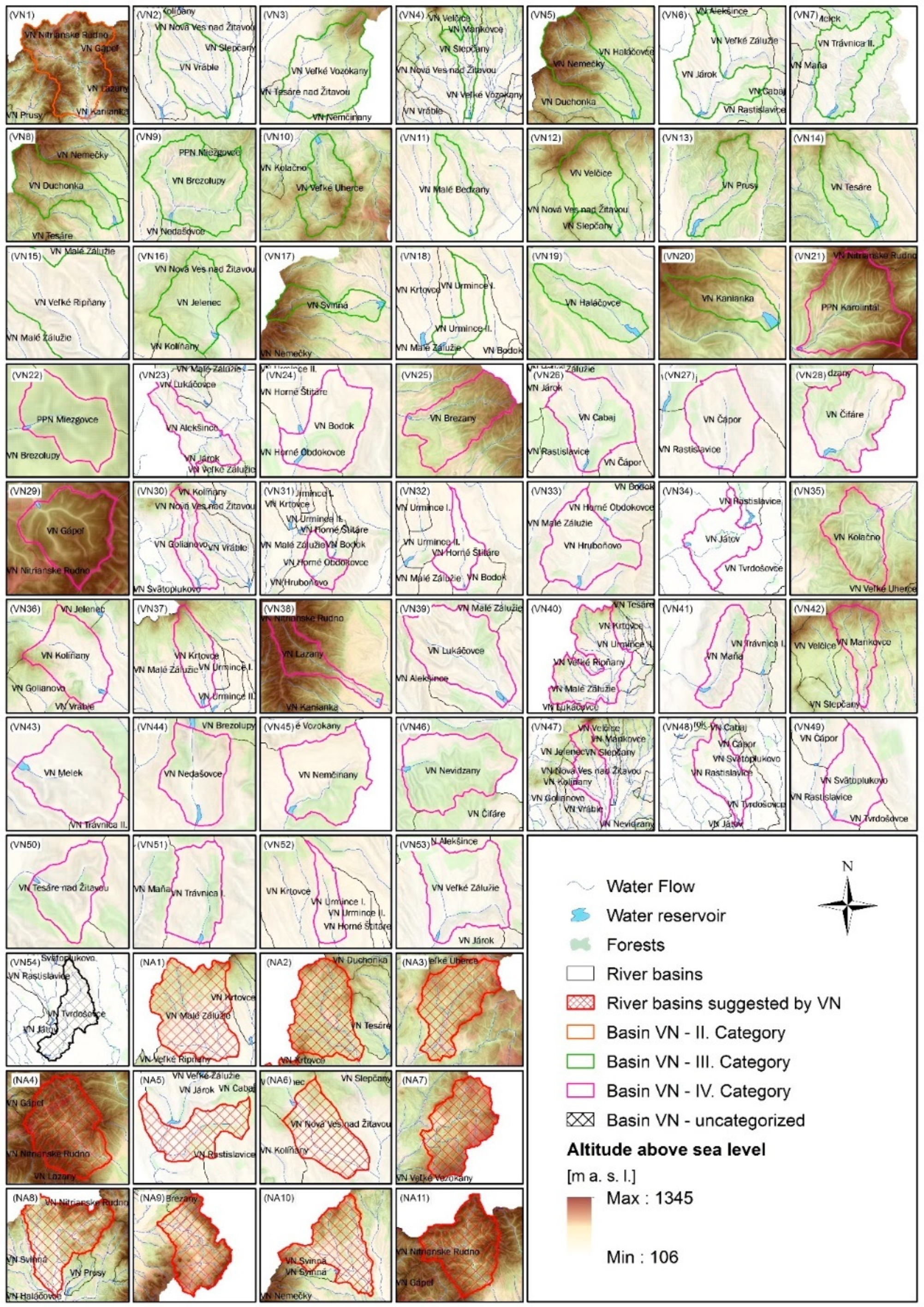
2.2. Demarcation of the Partial River Basins of Reservoirs

Each existing reservoir has had a river basis delimitated, from which the reservoir can retain the surface runoff. The analysis showed some river basins to have more integrated micro river basins than others. Subsequently, final profiles were defined for 11 new reservoirs at appropriate locations. From each new final profile, a river basin was generated, and all parameters were specified, and this was also determined for existing reservoirs. The new river basins for the localities suggested for new reservoirs were included in the cluster analysis (Figure 2).
Arable and forested land, as well as built-up areas within the river basin, were analyzed in terms of their requirements, and these were calculated for each river basin with regard to current use, as interpreted by ZBGIS, a map client for displaying, searching and analyzing spatial data and map services in Slovakia, providing, e.g., digital data of the real estate cadaster, address registers, land registers for leases, reference geodetic points, raster maps from the archive, digital relief model (also terrain), orthophotos and geographical names (available at: https://zbgis.skgeodesy.sk/mkzbgis?bm=zbgis&z=8&c=19.530000,48.800000#, retrieved at: (15. January 2020), and Land Register maps (data of the central real estate register in the Slovak Republic, available at: https://www.katasterportal.sk/kapor/vyhladavanieVlastnikFormInit.do, retrieved at: (28 February 2019). Figure 3 shows the percentage of land types in more detail.

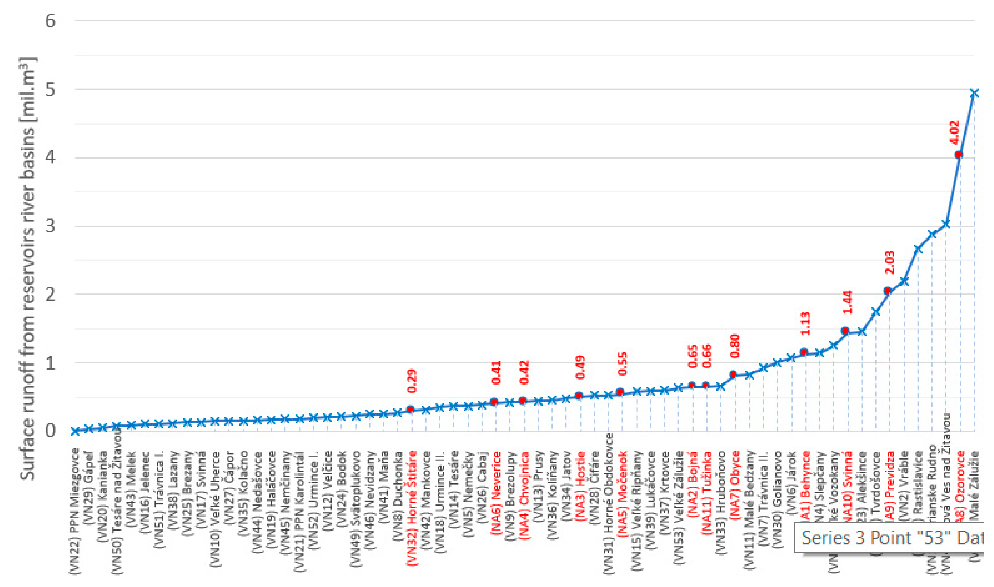
2.3. Calculation of the Volume of Surface Runoff from Reservoirs River Basins

The curve number method estimates direct runoff from precipitation in hydrologically non-monitored, mainly agriculturally exploited catchments. The input data consisted of how river basins were used, main soil units measured in rated soil ecological units (or BPEJ, soil quality measurement units used in Slovakia, available at: https://portal.vupop.sk/portal/apps/webappviewer/index.html?id=d89cff7c70424117ae01ddba7499d3ad, retrieved at: 28 February 2019), hydrological soil category according to Chow [34], and maximum daily precipitation (obtained from the Slovak Hydrometeorological Institute, http://www.shmu.sk/sk/?page=1&id=hydro_zra_all, by request of the authors). Results from the calculation of surface runoff volume are shown in Figure 4.

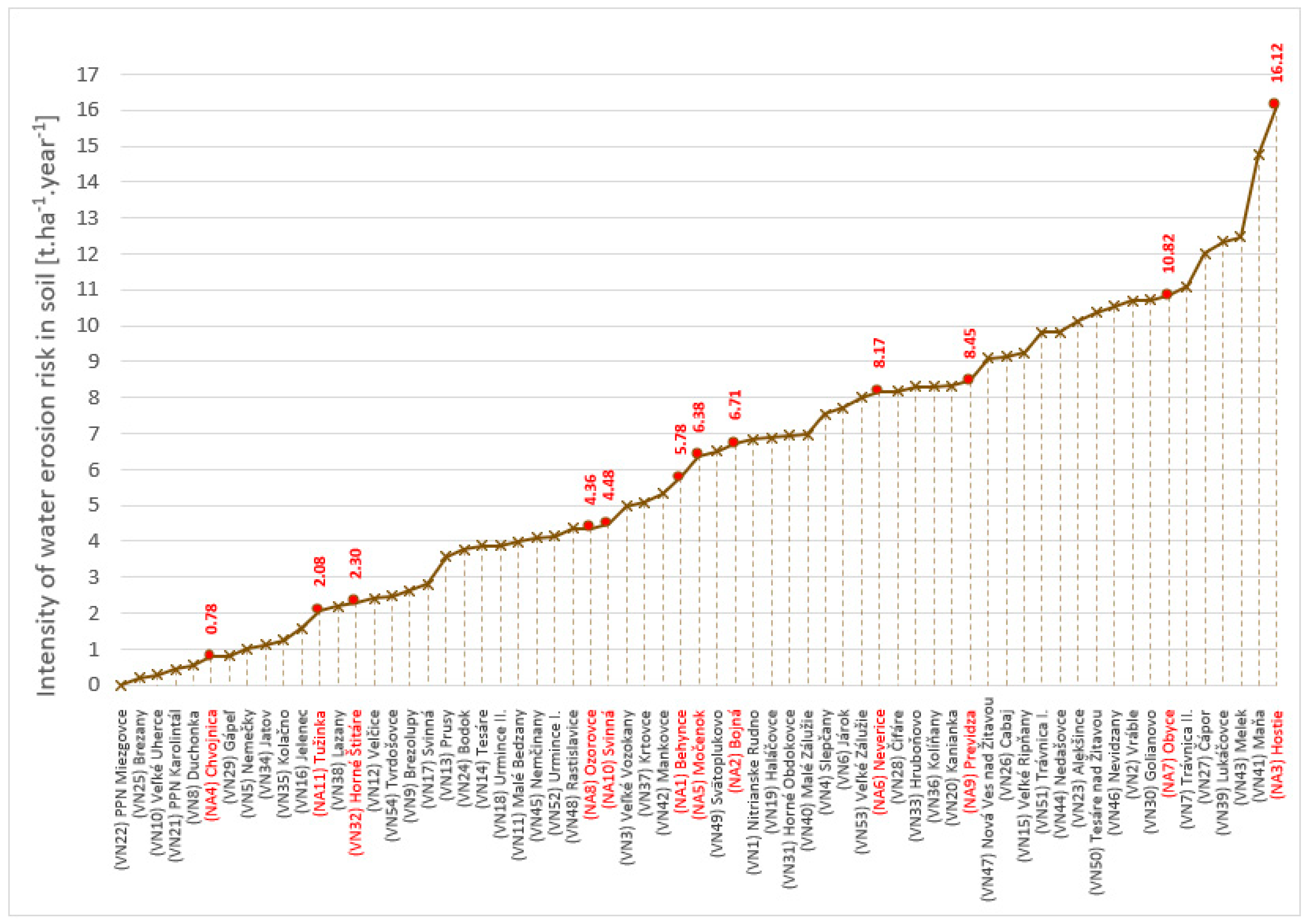
2.4. Calculation of Soil Loss by Water Erosion

To determine how much soil was lost through water erosion, the USLE (Universal Soil Loss Equation, Wischmeier and Smith, 1978 [35]) was used to empirically model predicted erosion loss. Input data comprised the values of the rainfall factor R for specific ombrographic stations (14.21–Trenčín, 14.42–Žilina, 14.61–Nové Zámky, 14.92–Malé Bielice, 15.4–Piešťany, 17.64–Dubník, 20.19–Motešice, 20.41–Trnava, 22.27–Nový Tekov, 24.62–Nitra, 25.71–Vráble, 26.34–Kremnica, 37.87–Nová Baňa) and of the soil erodibility factor K (ranging from 0.15–0.72, depending on the original type,). Other values were slope length (L) and slope inclination (S) as a topographic factor LS, according to Renard et al. [36] and ranging from 0–20), and the C factor for actual use of the area.
Actual exposure to water erosion of the soil was classified into seven categories measured by metric tons per hectare per year (t·ha−1·year−1) and allowing for the water management method and vegetation cover. The categories are 0–10, 10–20, 20–30, 30–50, 50–100, 100–280 and above 280. The calculation results for soil loss by water erosion are indicated in Figure 5. Using the ratio of calculated real erosion loss to permissible soil loss (governed in Slovakia by Act 220/2004 Coll. on the Protection and Use of Agricultural Land amending Act no. 245/2003 Coll. on Integrated Prevention and Control of Environmental Pollution amending certain other acts), the degree of erosion risk to the soil (SEOP) for five classifications was calculated [37] with the degree of erosion risk to the soil of erosion loss up to 1 t·ha−1·year−1 (SEOP1), from 1 to 2 t·ha−1·year−1 (SEOP2), from 2 to 7 t·ha−1·year−1 (SEOP3), from 7 to 28 t·ha−1·year−1 (SEOP4) and above 28 t·ha−1·year−1 (SEOP5).
SEOP is the degree of soil erosion risk by water erosion in five categories. If the SEOP is below or equal 1.00, it is a soil that is not endangered by water erosion. Otherwise, measures must be taken to limit the effects of water erosion as much as possible. SEOP is determined as the ratio of real soil loss to the allowable one. The allowable loss of soil is determined by the legislation [37].
Deliberately simple criteria that can be interpreted directly by all involved in the decision making and management of dam areas without a need for data analysts to interpret composed parameters have been chosen as to represent unequivocally clear influencing factors related to the size of the territory of interest, land cover/land use that is connected with water retention ability of the landscape, erosion connected to depositing sediments, and volume of water expected. The number of parameters is low, so no additional sophisticated methods [38] have been considered necessary in order to determine variables for estimating similarity of the areas. The analysis included the following measurable characteristics:
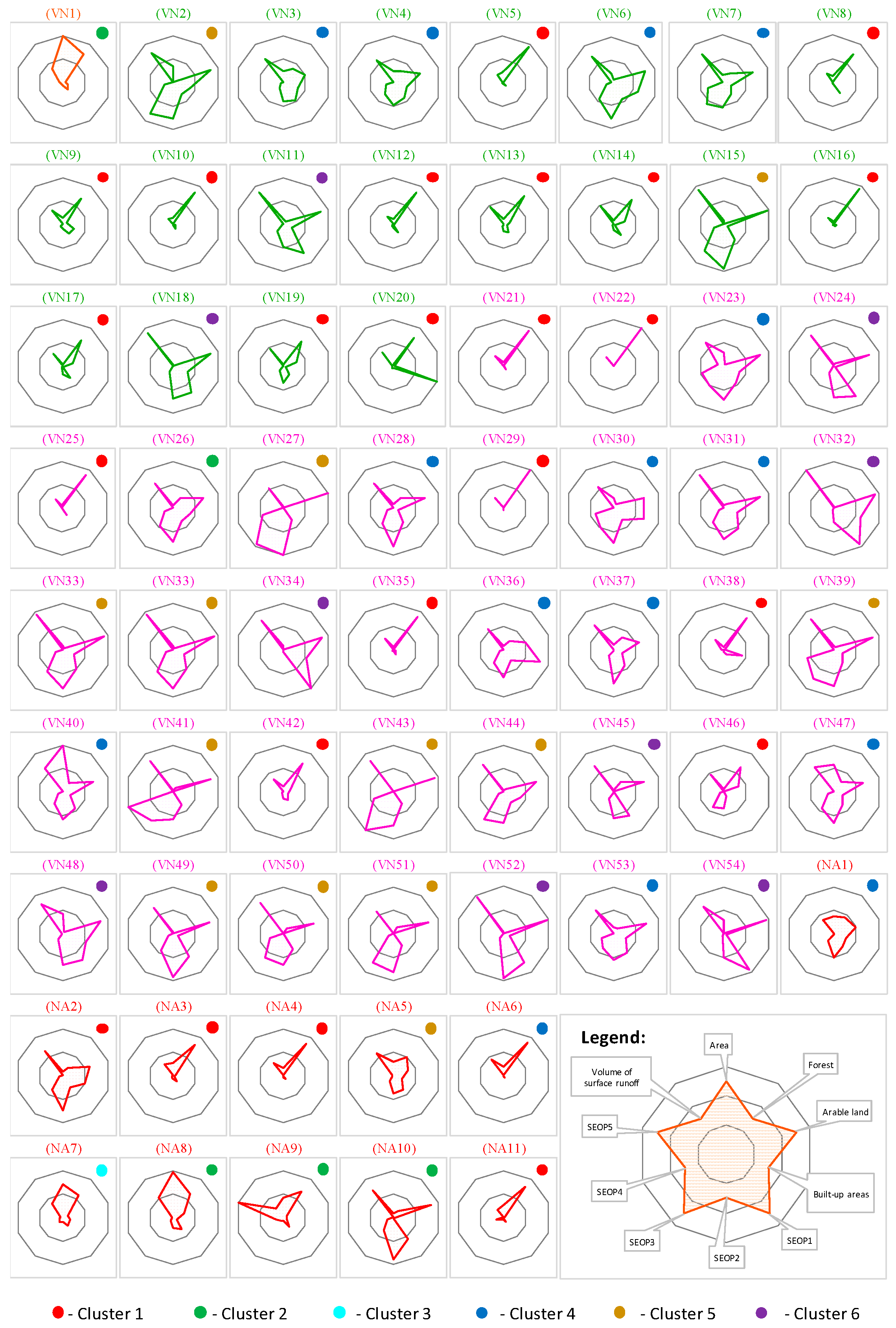
  • River basin area: identified area of individual reservoirs river basins up to the reservoir’s final profile.
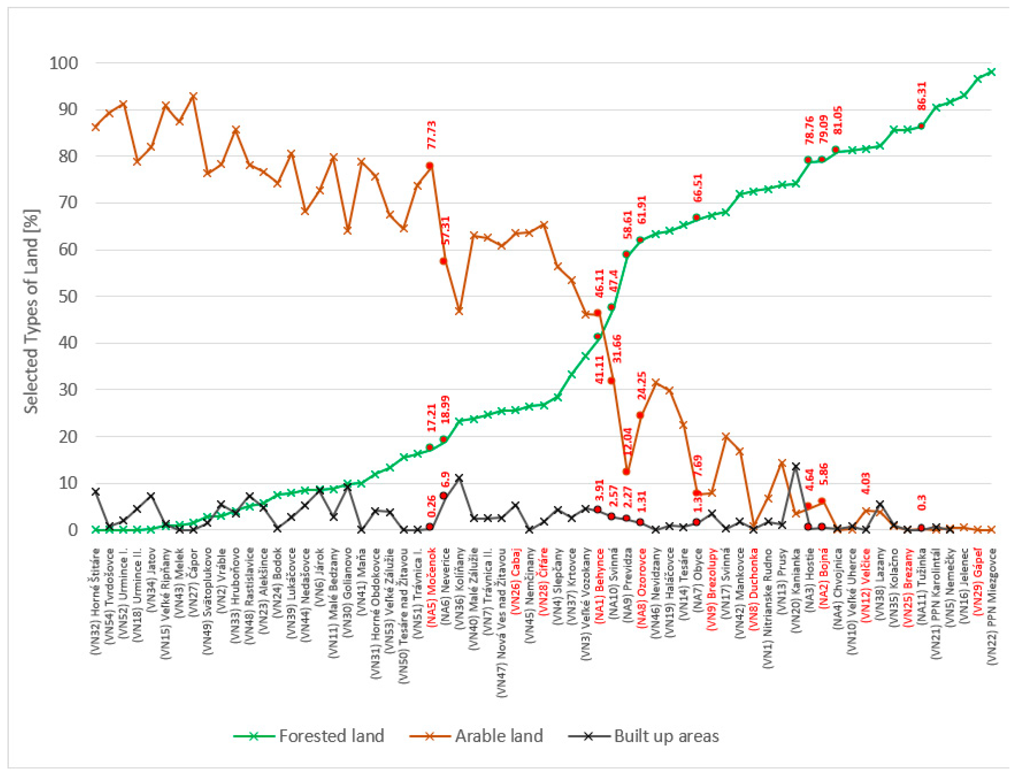
  • Arable and forested land: area of arable and forested land calculated for each river basin by current use, based on interpreted ZBGIS data and Land Register maps.
  • Built-up areas in the river basin: based on outputs from current use of the area, while specifying built-up areas in each river basin.
  • Erosion: erosion assessed from individual SEOP categories at each river basin in the five categories.
  • Volume of surface runoff towards the final reservoir profiles: calculated volume of surface runoff towards the final profile, using the runoff curve number method (CN-method).
Regarding the various sizes of individual river basins, the variables–the criteria–were applied to the river basin area and then standardly normalized for the maximum value of a given quantity; in other words, it was transformed to an interval [0.1]. To determine homogenous river basin reservoirs, a dendrogram was used that shows the hierarchical relationship between the river basins. It is most frequently created as an output from a hierarchical arrangement consisting of the main characteristics signifying the river basin reservoir. A cluster analysis was performed to determine hydrologically homogenous areas defined by the volume and selected physiographic and meteorological characteristics of the river basins. The underlying materials were assessed using descriptive statistical methods [39]. Divisive hierarchical clustering (DIANA), using the Manhattan metric, was applied to determine the similarity of the areas according to the selected criteria. DIANA [40] splits clusters based on their maximum average dissimilarity until each observation lands in its own single member cluster. DIANA’s benefits compared to other clustering methods are, for our purposes, as follows:
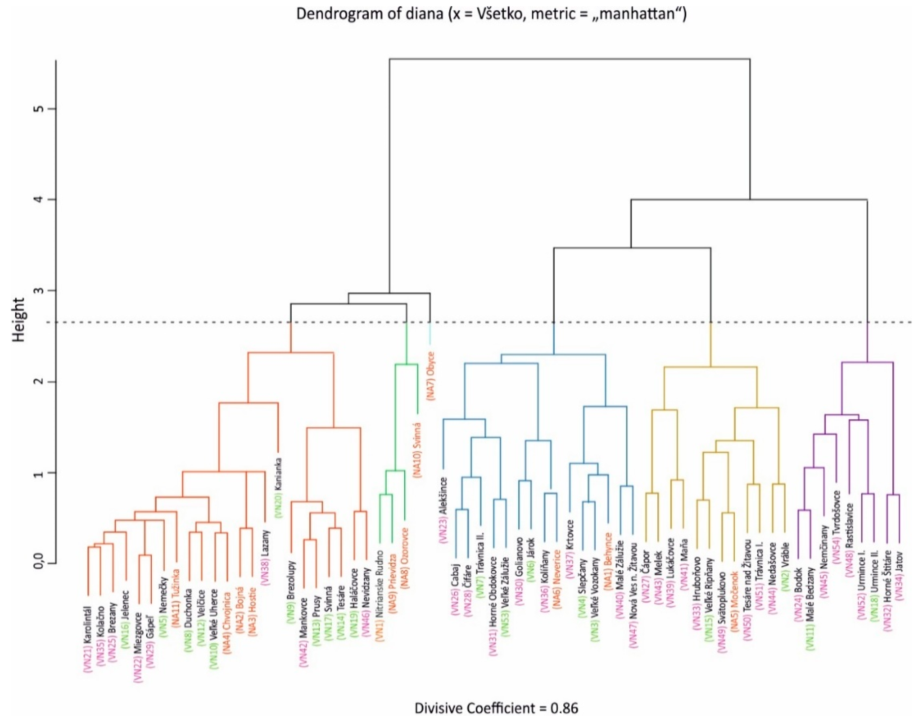
  • No predetermined number of clusters has to be specified;
  • Identification of larger clusters (to put new dam areas in for comparison);
  • It is a recommended robust technique [40,41] with an available implementation (https://www.r-project.org/, retrieved at: 29 February 2020).
There are 17 significant (p-value < 0.05) pairwise correlations (out of 45) among the parameters in the data, with only 3 strong (Pearson r > 0.8) ones, namely, negative correlation between the proportion of forested and arable land, negative correlation between the volume of the surface runoff with the share of forested land and positive one with the arable land portion). This also means that those variables have more weight in clustering. Correlation matrix has been used to identify the correlated parameters alongside the scatterplot matrix when exploring the data prior to other steps.

3. Results and Discussion

Detailing River Basin Reservoirs from All Assessed Criteria

Eleven new locations were demarcated for the new reservoirs. These are Behynce, Bojná, Hostie, Chvojnica, Močenok, Neverice, Obyce, Ozorovce, Previdza, Svinná and Tužinka. A partial river basin and all input criteria were generated for each proposed final profile of a potential new reservoir, which were created also for existing hydraulic structures and the river basins where they were situated. The river basins at the suggested locations suggested for the new and existing reservoirs were included in the cluster analysis. Based on the selected characteristics (river basin area, arable and forested land, built-up areas in the river basins, erosion and volume of surface runoff towards the final reservoir profiles), existing and new river basins were divided into 6 clusters and a cluster analysis was performed (Figure 6).
It is assumed for a particular cluster that all the river basins for existing and new reservoirs are similar in a certain sense and have roughly comparable analyzed characteristics, thus similar management, demands and administration of river basins can obviously be expected. This also enables the preparation of orientation frameworks for new reservoirs parameters and point out characteristics relevant for area management with respect to the experience obtained from the environment of other reservoirs demarcated in the same cluster. Graphically depicts the set of data in the Figure 7. Data characteristics from individual clusters are shown in Table 2 and Figure 8.
The first cluster contains 23 smaller river basins with a significantly higher percentage of forested land, while arable soil and built-up areas are minimal. The volume of surface runoff is the second lowest of all the clusters, and the area is not affected by water erosion.
The second cluster comprises four river basins, including the river basin for the existing Nitrianske Rudno reservoir (VN1) and three of the suggested reservoirs. All the locations are spread over the largest area of all the river basins, with 63% forestland and 16% arable land. The river basins are slightly affected by water erosion.
The third cluster covers a single river basin for the proposed Obyce reservoir (NA7) only. Its characteristics are roughly similar to the river basins in the second (and partially the first) cluster except for the percentage of arable land, which is the lowest among all the river basins. This clearly separates the river basin in question from the second cluster. The area is mildly affected by water erosion.
The fourth cluster is formed from 16 river basin reservoirs, characterized by a larger percentage of arable land (61%), a lower percentage of forested land (24%) and the highest percentage of built-up areas in the river basin (4%). SEOP places the fourth river basin cluster moderately among those significantly affected by water erosion of the soil.
The fifth cluster comprises 12 river basins with minimum forested land, a high percentage of arable land and a high volume of surface runoff from the river basin.
The sixth cluster has the largest percentage of arable land (82%), while the percentage of forestland is the lowest among all the river basins (4%) studied. The area is slightly affected by water erosion and has a high volume of river basin surface runoff.
The localization of the existing and new reservoirs into clusters with various levels of similarity allows us to estimate adequate approaches to the potential optimization of activities in the river basins of the potential new water structures, for example, the proposed Neverice reservoir (NA 6). The results clearly show that, prior to construction of the reservoir, measures will need to be implemented in order to prevent local water erosion. This could prevent soil erosion loss, which currently is a widespread problem. If neglected, silt would build up in the reservoir, increasing operational expenses for removing it and endangering dam safety. One of the significant projected reservoir parameters is the determination of surface runoff from river basins. If arable soil accumulates in reservoirs, overall reservoir volume parameters will change. This is often overlooked until the reservoir is fully drained. Deposited sediments change the accumulated volume of water, which the reservoir would otherwise be able to catch. Heavy rainfall a reservoir is not be capable of accumulating because of water erosion would lead to an increase in runoff through the safety overflow, causing the area below the reservoir to be flooded, while the dam could be destroyed, endangering human lives and property below the reservoir.
However, this study differs from the previous classification studies in terms of the variables used. The variables chosen, in our opinion, have the greatest impact on river basis reservoir administration and management. These links can be utilized to develop useful information at watersheds featuring similar patterns. Arranging existing and new reservoirs into clusters allows an estimation of adequate approaches to potential optimization of activities carried out in problem river basins for hydraulic structures.
This study categorizes river basins, using the example of the Nitra River. However, it is applicable to all of Slovakia.

4. Conclusions

Divisive hierarchical clustering of existing and potential dam locations based on the area size, proportion of arable land, forestland and built-up area, degree of exposure to soil erosion and the volume of surface runoff allows to identify possible issues that might be relevant to area management using experience obtained from the environment of other sites. Six clusters of reservoir basins have been identified in the Nitra River Basin (located in Nitra District, Nitra Region in Slovakia) that played the role of the model case.
First cluster contains 23 smaller locations including 4 new sites, the second one 4 (3 new), third cluster represent a unique case of one new site, cluster four has 16 members (with 2 proposed sites), the fifth 12 (one proposed site), and the last cluster six has 9 members (with no new site).
As the proposed Neverice reservoir shows, the present analysis could help to highlight problems, local water erosion in this case, that have to be addressed and taken into account before and during reservoir construction and subsequent operation.

Author Contributions

Conceptualization; methodology; investigation; writing and resources, I.G., Z.M., L.J.; data curation, I.G., Z.M., L.J., K.Š., L.F., F.P.; formal analysis, K.Š., L.F., F.P.; visualization, I.G., Z.M.; project administration, funding acquisition, and correspondence, I.G., Z.M., L.J., F.P. All authors have read and agreed to the published version of the manuscript.

Funding

This work has been supported by the Slovak Research and Development Agency under Project APVV-16-0278, use of hydromelioration structures for mitigation of the negative extreme hydrological phenomena effects and their impacts on the quality of water bodies in agricultural landscapes, and by the scientific grant agency VEGA 1/0706/20, Urban sustainable development in the 21st century—assessment of key factors, planning approaches, and environmental relationships.

Conflicts of Interest

The authors declare no conflicts of interest.

References

  1. Briney, A. Dams and Reservoirs. Available online: https://thoughtco.com/dams-and-reservoirs-1435829 (accessed on 11 February 2020).
  2. Just, T.; Moravec, P.; Šámal, V.; Frnková, L. Obnova Malých Vodních Nádrží Jako významných Krajinných Prvků [Restoration of Small Water Reservoirs as Important Landscape Elements], 1st ed.; Agentúra Ochrany Přírody a Krajiny České Republiky: Praha, Czech Republic, 2009. [Google Scholar]
  3. Munoth, P.; Munoth, R. Impacts of Land Use Land Cover Change on Runoff and Sediment Yield of Upper Tapi River Sub Basin, India. Int. J. of River Basin Manag. 2020, 18, 177–189. [Google Scholar] [CrossRef]
  4. Jakubcová, A.; Grežo, H. Impacts of Flooding on the Quality of Life in Rural Regions of Southern Slovakia. Appl. Res. Qual. Life 2016, 1, 221–237. [Google Scholar] [CrossRef]
  5. Jurík, Ľ.; Zeleňáková, M.; Kaletová, T.; Arifjanov, A. Small Water Reservoirs: Sources of Water for Irrigation. In Water Resources in Slovakia. Part 1; Negm, A.M., Zeleňáková, M., Eds.; Springer International Publishing Birkhäuser Verlag AG: Basel, Switzerland, 2018; pp. 115–131. [Google Scholar] [CrossRef]
  6. Grabic, J.; Bezdan, A.; Benka, P.; Salvai, A. Spreading and Transformation of Nutrients in the Reach of the Becej-Bogojevo Canal, Serbia Spreading and Transformation of Nutrients in the Reach of the Becej-Bogojevo Canal, Serbia. Carpathian. J. Earth Environ. Sci. 2011, 6, 277–284. [Google Scholar]
  7. Muchová, Z.; Tárníková, M. Land Cover Change and its Influence on the Assessment of the Ecological Stability. Appl. Ecol. Environ. Res. 2018, 16, 2169–2182. [Google Scholar] [CrossRef]
  8. Tárník, A.; Leitmanová, M. Analysis of the Development of Available Soil Water Storage in the Nitra River Catchment. In IOP Conference Series-Materials Science and Engineering; IOP Publishing LTD, Dirac House, Temple Back, Bristol BS1 6BE, England; IOP Publishing: Prague, Czech Republic, 2017. [Google Scholar] [CrossRef]
  9. Dundjerski, J.J.; Savic, R.; Grabic, J. Water Quality Trends of the Tisa River along Its Flow through Serbia. Annu. Set Environ. Prot. 2017, 19, 17–35. [Google Scholar]
  10. Izakovičová, Z.; Špulerová, J.; Petrovič, F. Integrated Approach to Sustainable Land Use Management. Environments 2018, 5, 37. [Google Scholar] [CrossRef] [Green Version]
  11. Jurík, L.; Húska, D.; Halászová, K.; Bandlerová, A. Small Water Reservoirs—Sources of Water or Problems? J. Ecol. Eng. 2015, 16, 22–28. [Google Scholar] [CrossRef]
  12. Lepška, T. Ecohydrology & Hydrobiology Hydric Potential of Selected River Basins in Slovakia. Ecohydrol. Hydrobiol. 2013, 13, 201–209. [Google Scholar] [CrossRef]
  13. Brath, A.; Montanari, A.; Moretti, G. Assessing the Effect on Flood Frequency of Land Use Change via Hydrological Simulation (with Uncertainty). J. Hydrol. 2006, 324, 141–153. [Google Scholar] [CrossRef]
  14. Langhammer, J.; Vilímek, V. Landscape Changes as a Factor Affecting the Course and Consequences of Extreme Floods in the Otava River Basin, Czech Republic. Environ. Monit. Assess. 2008, 144, 53–66. [Google Scholar] [CrossRef]
  15. Jurík, Ľ.; Halászová, K.; Pokrývková, J.; Rehák, Š. Irrigation of Arable Land in Slovakia: History and Perspective. In Water resources in Slovakia. Part 1; Negm, A.M., Zeleňáková, M., Eds.; AG, Springer International Publishing: Basel, Switzerland, 2018; pp. 81–96. [Google Scholar] [CrossRef]
  16. Wojkowski, J.; Młyński, D.; Lepeška, T.; Wałęga, A.; Radecki-Pawlik, A. Science of the Total Environment Link between Hydric Potential and Predictability of Maximum Fl Ow for Selected Catchments in Western Carpathians. Sci. Total Environ. J. 2019, 683, 293–307. [Google Scholar] [CrossRef] [PubMed]
  17. Štátny vodohospodársky plán Československej Republiky. In Hlavné Povodie Dunaja. Čiastkové povodie XXIX—Nitra. Diel II. a III.—Text. [State Water Management Plan. of the Czechoslovak Republic. The Main Catchment Area of the Danube. Partial Catchment Area XXIX—Nitra. Part. II. a III. —Text.]; Vodohospodárke Rozvojové Stredisko, Water Management Development Centre: Bratislava, Slovakia, 1956.
  18. Havlíček, M.; Pavelková, R.; Frajer, J.; Skokanová, H. The Long-Term Development of Water Bodies in the Context of Land Use: The Case of the Kyjovka and Trkmanka River Basins (Czech Republic). Morav. Geogr. Rep. 2014, 22, 39–50. [Google Scholar] [CrossRef] [Green Version]
  19. Tárník, A.; Igaz, D. Spatial Scale Analysis of Soil Water Content in Agricultural Soils of the Nitra River Catchment (Slovakia). J. Ecol. Eng. 2020, 21, 112–119. [Google Scholar] [CrossRef]
  20. Ya, L.; Zhao, C.; Yang, S.; Cai, M.; Zhou, Q. A Soil Erosion Assessment of the Upper Mekong River in Yunnan Province, China. Mt. Res. Dev. 2014, 34, 36–47. [Google Scholar] [CrossRef]
  21. Schuetze, T.; Chelleri, L. Climate Adaptive Urban Planning and Design with Water in Dutch Polders. Water Sci. Technol. 2011, 722–730. [Google Scholar] [CrossRef] [PubMed]
  22. Mosley, L.M. Earth-Science Reviews Drought Impacts on the Water Quality of Freshwater Systems; Review and Integration. Earth Sci. Rev. 2015, 140, 203–214. [Google Scholar] [CrossRef]
  23. Karásek, P.; Konečná, J.; Pochop, M.; Kučera, J.; Podhrázská, J. Priority Areas for Initiating Land Consolidations Related to Erosion and Water Retention in the Landscape, Czech Republic. J. Ecol. Eng. 2018, 19, 16–28. [Google Scholar] [CrossRef]
  24. Petrovič, F.; Stránovský, P.; Muchová, Z.; Falťan, V.; Skokanová, H.; Havlíček, M.; Gábor, M.; Špulerová, J. Landscape-Ecological Optimization of Hydric Potential in Foothills Region with Dispersed Settlements—A Case Study of NovÁ BoŠÁca, Slovakia. Appl. Ecol. Environ. Res. 2017, 15. [Google Scholar] [CrossRef]
  25. Pavelková, R.; Frajer, J.; Havlíček, M.; Netopil, P.; David, V.; Dzuráková, M.; Šarapatka, B. Historical Ponds of the Czech Republic: An Example of the Interpretation of Historic Maps. J. Maps 2016, 5647, 551–559. [Google Scholar] [CrossRef] [Green Version]
  26. Zhang, H.; Jin, G.; Yu, Y. Review of River Basin Water Resource Management in China. Water 2018, 10, 425. [Google Scholar] [CrossRef] [Green Version]
  27. Doležal, P.; Kone, J.; Karásek, P.; Podhrázská, J.; Pochop, M. Water Retention in a Small Agricultural Catchment and its Potential Improvement by Design of Water Reservoirs—A Case Study of The Bílý Potok Catchment (Czechia). Eur. Countrys. 2018, 10, 1–22. [Google Scholar] [CrossRef] [Green Version]
  28. Lepeška, T.; Radecki-Pawlik, A.; Wojkowski, J.; Walega, A. Hydric Potential of the River Basin: Pradnik, Polish Highlands. Acta Geophys. 2017, 65, 1253–1267. [Google Scholar] [CrossRef]
  29. Dikbas, F.; Firat, M.; Koc, A.C. Defining Homogeneous Regions for Streamflow Processes in Turkey Using a K-Means Clustering Method. Arab. J. Sci. Eng. 2013, 38, 1313–1319. [Google Scholar] [CrossRef]
  30. Li, Q.; Li, Z.; Zhu, Y.; Deng, Y.; Zhang, K.; Yao, C. Hydrological Regionalisation Based on Available Hydrological Information for Runoff Prediction at Catchment Scale. Proc. IAHS 2018, 379, 13–19. [Google Scholar] [CrossRef] [Green Version]
  31. Lecce, S.A. Spatial Variations in the Timing of Annual Floods in the Southeastern United States. J. Hydrol. 2000, 235, 151–169. [Google Scholar] [CrossRef]
  32. Kahya, E.; Demirel, M.C.; Bég, O.A. Hydrologic Homogeneous Regions using Monthly Streamflow in Turkey. Earth Sci. Res. J. 2008, 12, 181–193. [Google Scholar]
  33. Cupak, A.; Walega, A.; Michalec, B. Cluster Analysis in Determination of Hydrologically Homogeneous Regions with Low Flow. Acta Sci. Pol. Form. Circumiectus 2017, 16, 53–63. [Google Scholar] [CrossRef]
  34. Chow, V.T. Handbook of Applied Hydrology; McGraw Hill: New York, NY, USA, 1964. [Google Scholar]
  35. Wischmeier, W.H.; Smith, D.D. Predicting Rainfall Erosion Losses. In Agricultural Handbook No. 537; USDA: Washington, DC, USA, 1978. Available online: https://naldc.nal.usda.gov/download/CAT79706928/PDF (accessed on 13 February 2018).
  36. Renard, K.G.; Yoder, D.C.; Ligchtle, D.T.; Dabney, S.M. Universal Soil Loss Equation and Revised Universal Soil Loss Equation. In Handbook of Erosion Modelling; Morgan, R.P.C., Nearing, M.A., Eds.; Blackwell Publishing: Hoboken, NJ, USA, 2011; pp. 137–167. [Google Scholar]
  37. Alena, F. Stanovenie Straty Pôdy Erozívnym Splachom pre Navrhovanie Protieróznych Opatrení: Metodická Pomôcka [Determination of Soil Loss by Erosive Flushing for the Design of Anti-Erosion Measures: Methodological Aid]; Hydromeliorácie, š. p. BW Hydromelioration: Bratislava, Slovakia, 1986. [Google Scholar]
  38. Kheirfam, H.; Vafakhah, M. Assessment of some Homogeneous Methods for the Regional Analysis of Suspended Sediment Yield in the South and Southeast of the Caspian Sea. J. Earth Syst. Sci. 2015, 124, 1247–1263. [Google Scholar] [CrossRef]
  39. Pechanec, V.; Brus, J.; Kilianová, H.; Machar, I. Decision Support Tool for the Evaluation of Landscapes. Ecol. Inform. 2015, 30, 305–308. [Google Scholar] [CrossRef]
  40. Kaufman, L.; Rousseeuw, P.J. Finding Groups in Data: An. Introduction to Cluster Analysis; John Wiley & Sons: Hoboken, NJ, USA, 2005. [Google Scholar]
  41. Lopuhaä, H.P.; Rousseeuw, P.J. Breakdown Points of Affine Equivariant Estimators of Multivariate Location and Covariance Matrices. Ann. Stat. 1991, 19, 229–248. [Google Scholar] [CrossRef]
Figure 1. Division of reservoirs in Nitra river basin by risk factor.
Water 12 02042 g001
Figure 2. Modeled partial river basins for existing and new reservoirs.
Water 12 02042 g002
Figure 3. The Percentage of selected types of land.
Water 12 02042 g003
Figure 4. Volume of surface runoff from reservoirs river basins.
Water 12 02042 g004
Figure 5. Intensity of water erosion risk in soil.
Water 12 02042 g005
Figure 6. Divisive analysis (DIANA) of hierarchical clustering with Manhattan metric, including “all the criteria” (Divisive Coefficient = 0.86).
Water 12 02042 g006
Figure 7. Graphic depiction of the set of individual reservoir data.
Water 12 02042 g007
Figure 8. Map projection of the details of individual clusters.
Water 12 02042 g008
Table 1. Dams by the “risk factor”.
Risk Factor CategoriesNumber of SitesRanges of Risk Factor “F”
II 1 150 ≤ F < 1000
III 19 15 ≤ F < 150
IV 33 1 ≤ F < 15
Uncategorized1Tvrdošovce (VN54)
Table 2. Overall data characteristics of individual clusters.
Clusters 1–6Area of BasinForested LandArable LandBuilt-up AreaSEOP 1SEOP 2SEOP 3SEOP 4SEOP 5Surface Runoff from Reservoirs River Basins
(km2)(km2)(km2)(km2)(-)(-)(-)(-)(-)(m3)
Min.:0.550.00000.00000.00000.000000.000000.000000.000000.000006773
1st Qu.:8.010.08610.06810.00260.161200.012890.014060.000030.0000017,079
Median:15.570.26720.56360.01670.260100.114440.057880.001430.0000030,236
Mean:29.050.40530.44720.02650.288500.097090.107850.008770.0000327,860
3rd Qu.:35.820.72980.76280.04110.365500.162990.185670.010600.0000036,231
Max.:157.890.98180.92870.13690.839000.234970.429850.084050.0012550,416

