Evaluation of the Stability and Suitable Scale of an Oasis Irrigation District in Northwest China

Abstract
:1. Introduction
2. Materials and Methods
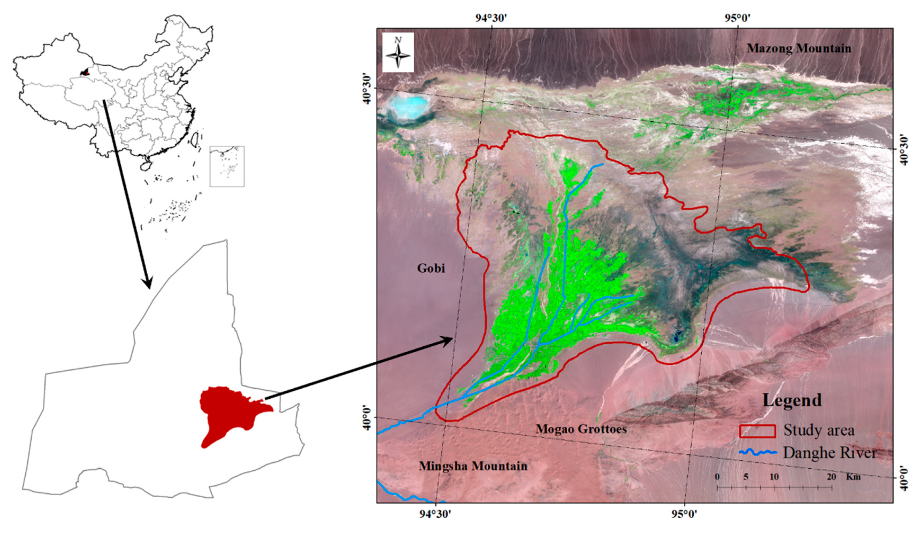
2.1. Study Area
2.2. Remote Sensing Image Data Processing
2.3. Water Consumption Data Analyses
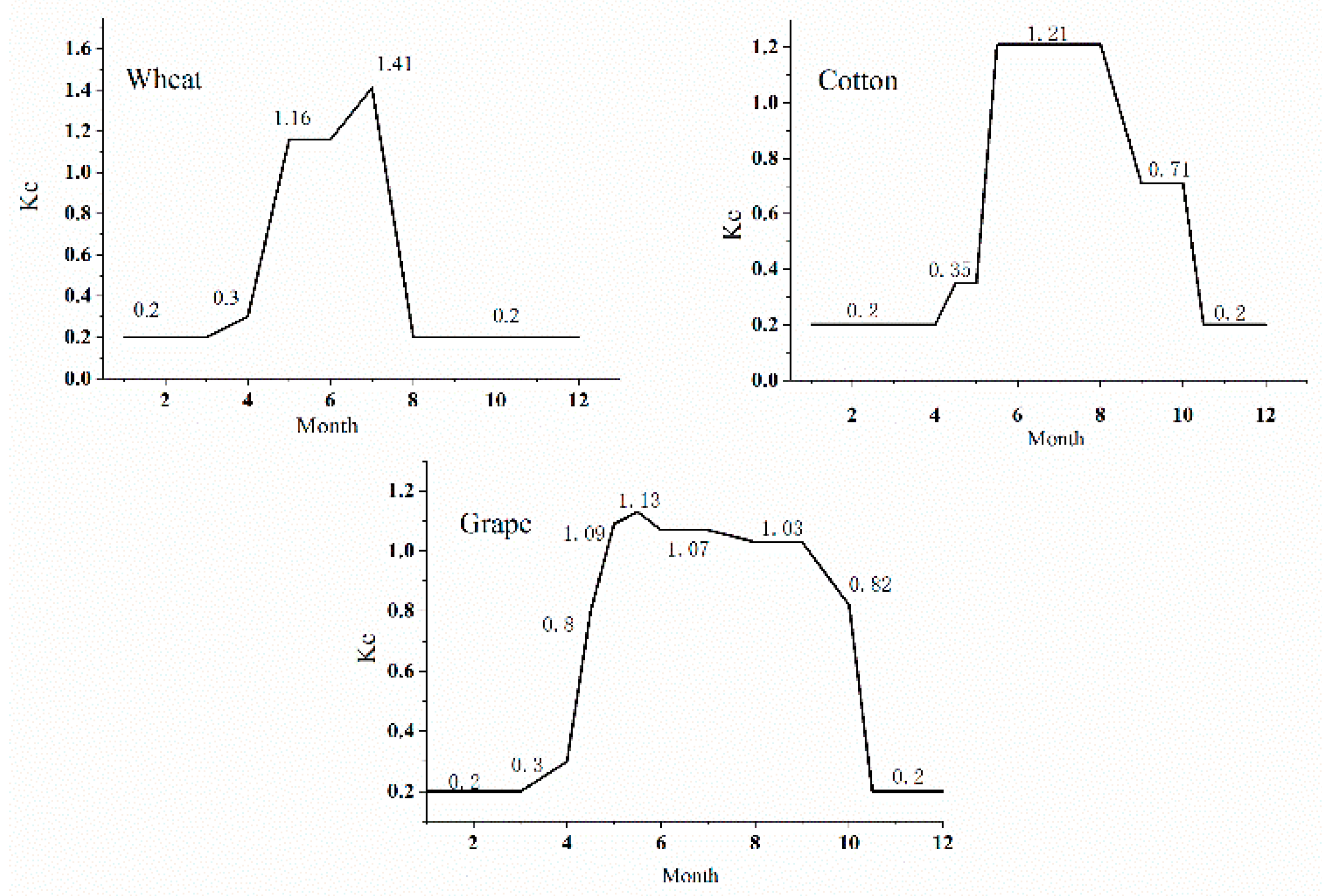
2.3.1. Crop Water Consumption
- Rn is the net radiation at the canopy surface (MJ/m2. day);
- G is the soil heat flux density (MJ/m2. day);
- T is the mean daily air temperature at 2 m above the ground (°C);
- U2 is the wind speed at 2 m above the ground (m/s);
- es is the saturation vapor pressure (kPa);
- ea is the actual vapor pressure (kPa);
- es − ea is the saturation vapor pressure deficit (kPa);
- Δ is the slope of the vapor pressure temperature relationship (kPa/°C);
- γ is the psychometric constant (kPa /°C).
- Kcmid(Tab) is the tabulated Kc values in the mid-seasonof Table VI-12 of Allen et al. [24];
- Kcend(Tab) is the tabulated Kc values in the late-season of Table VI-12 of Allen et al. [24];
- U2 is wind speed at 2 m height over grass, the range is 1 m/ s ≤ U2 ≤ 6 m m/s;
- RHmin is daily minimum relative humidity, the range is 20% ≤ RHmin ≤ 80%;
- H is mean plant height, the range is 0.1 m ≤ h ≤ 10 m.
2.3.2. Domestic Water Consumption
- D is the total domestic water consumption (108 m3);
- P1 is the amount urban population (108 m3);
- P2 is the amount rural population (108 m3);
- P3 is the amount tourists population (108 m3);
- P4 is the amount livestock number (108 m3, sheep unit);
- C1 is the average per capital water use coefficient of urban (L/day);
- C2 is the average per capital water use coefficient of rural (L/day);
- C3 is the average per capital water use coefficient of tourist (L/day);
- C4 is the average per capital water use coefficient of livestock (L/day);
2.3.3. Industrial Water Consumption
- P is the industry water use (108 m3);
- Indo is the industrial output (RMB);
- C5 is the amount of water used to create 10,000 RMB worth of industrial output (m3/104 RMB).
2.4. Oasis Stability and Suitable Oasis Scale Model
3. Results
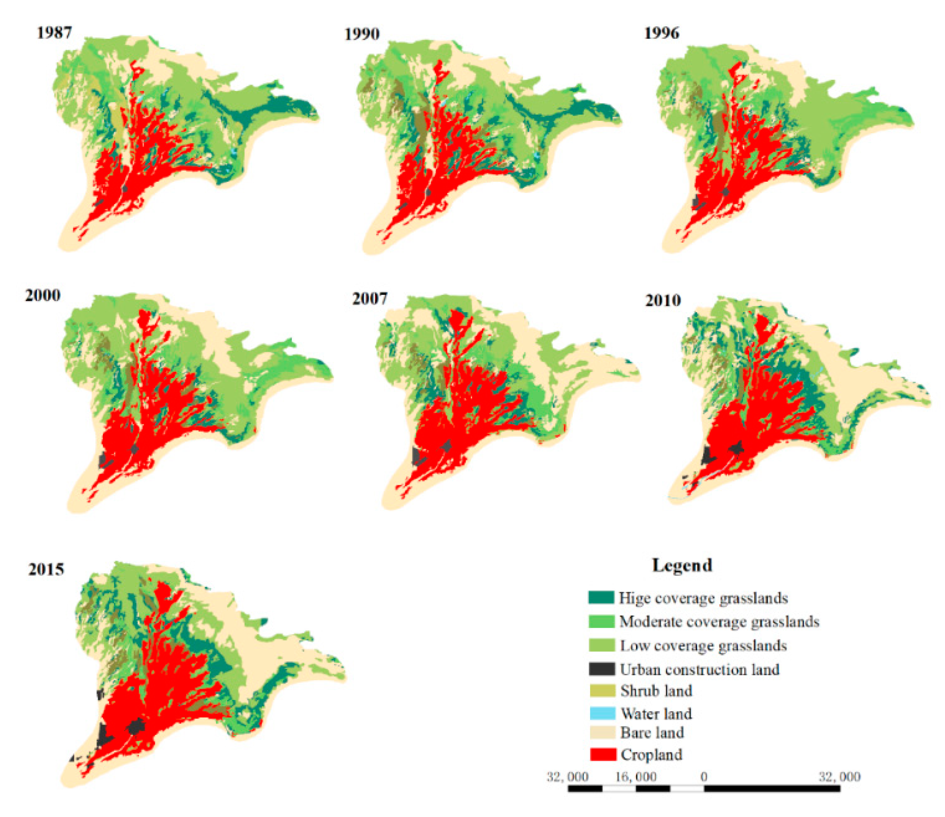
3.1. Land Use/Land Cover Changes between 1987 and 2015
3.2. Water Consumption
3.2.1. Agricultural Water Consumption
3.2.2. Domestic and Industrial Water Consumption
3.3. Oasis Stability Evaluation
3.4. Suitable Oasis Irrigation District Scale
4. Discussion
5. Conclusions
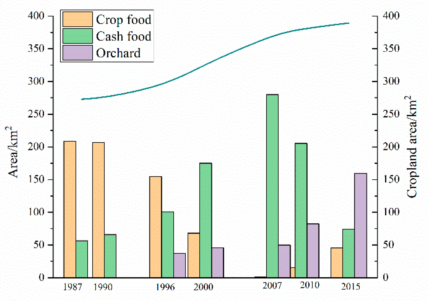
- From 1987 to 2015, the oasis irrigation district area expanded internally and externally, and, at the same time, the planting structure underwent a marked transformation, from food crops to cash crops to orchards. In the Dunhuang Oasis, the structure of croplands might be quickly and flexibly changed according to economic perspective and visions and policy reforms
- In the Dunhuang Oasis, agricultural water consumption is mainly for food crops, cash crops, and orchards. From 1987 to 2015, food crop water consumption decreased sharply by 1.334 × 10⁸ m3, cash crop water consumption (cotton) first increased by 2.374 × 10⁸ m3 and then decreased substantially, and grape water consumption was closely related to that of cotton, which increased slowly in 2010 before rising rapidly.
- The Dunhuang Oasis was at a stable level in 1987 and 1990 but gradually declined until it reached a dangerously unstable level in 2010. Meanwhile, serious ecological problems emerged one after the other. Against the background of water-saving measures and the water-transfer project, the stable level of the oasis increased to a metastable level of 0.22 in 2015.
- The oasis irrigation district should be reduced by at least 168 km2 to reach a suitable scale. However, this goal does not facilitate the improvement of the living standards of farmers and is not in line with the Chinese policy of farmland protection. Hence, the most practical way at present is to increase allocated water resources from the water-transfer project to the oasis irrigation district.
Author Contributions
Funding
Conflicts of Interest
References
- Li, X.; Cheng, G.; Ge, Y.; Li, H.; Han, F.; Hu, X.; Tian, W.; Tian, Y.; Pan, X.; Nian, Y.; et al. Hydrological Cycle in the Heihe River Basin and Its Implication for Water Resource Management in Endorheic Basins. J. Geophys. Res. Atmos. 2018, 123, 890–914. [Google Scholar] [CrossRef]
- Ling, H.; Xu, H.; Fu, J.; Fan, Z.; Xu, X. Suitable oasis scale in a typical continental river basin in an arid region of China: A case study of the Manas River Basin. Quat. Int. 2013, 286, 116–125. [Google Scholar] [CrossRef]
- Wang, Z.; Ficklin, D.L.; Zhang, Y.; Zhang, M. Impact of climate change on streamflow in the arid Shiyang River Basin of northwest China. Hydrol. Process. 2012, 26, 2733–2744. [Google Scholar] [CrossRef]
- Kang, S.; Su, X.; Tong, L.; Zhang, J.; Zhang, L. A warning from an ancient oasis: Intensive human activities are leading to potential ecological and social catastrophe. Int. J. Sustain. Dev. World Ecol. 2008, 15, 440–447. [Google Scholar] [CrossRef]
- De Fraiture, C.; Molden, D.; Wichelns, D. Investing in water for food, ecosystems, and livelihoods: An overview of the comprehensive assessment of water management in agriculture. Agric. Water Manag. 2010, 97, 495–501. [Google Scholar] [CrossRef]
- Cheng, G.; Li, X.; Zhao, W.; Xu, Z.; Feng, Q.; Xiao, S.; Xiao, H. Integrated study of the water–ecosystem–economy in the Heihe River Basin. Natl. Sci. Rev. 2014, 1, 413–428. [Google Scholar] [CrossRef] [Green Version]
- Custodio, E.; Andreu-Rodes, J.M.; Aragón, R.; Estrela, T.; Ferrer, J.; García-Aróstegui, J.L.; Manzano, M.; Rodríguez-Hernández, L.; Sahuquillo, A.; del Villar, A. Groundwater intensive use and mining in south-eastern peninsular Spain: Hydrogeological, economic and social aspects. Sci. Total Environ. 2016, 559, 302–316. [Google Scholar] [CrossRef] [Green Version]
- Micklin, P.P. Desiccation of the Aral Sea: A water management disaster in the Soviet Union. Science 1988, 241, 1170–1176. [Google Scholar] [CrossRef] [Green Version]
- Klein, I.; Dietz, A.J.; Gessner, U.; Galayeva, A.; Myrzakhmetov, A.; Kuenzer, C. Evaluation of seasonal water body extents in Central Asia over the past 27 years derived from medium-resolution remote sensing data. Int. J. Appl. Earth Obs. Geoinf. 2014, 26, 335–349. [Google Scholar] [CrossRef]
- Stone, R. Saving Iran’s Great Salt Lake; American Association for the Advancement of Science: Washington, DC, USA, 2015; Volume 349, pp. 1044–1047. [Google Scholar]
- Tourian, M.; Elmi, O.; Chen, Q.; Devaraju, B.; Roohi, S.; Sneeuw, N. A spaceborne multisensor approach to monitor the desiccation of Lake Urmia in Iran. Remote Sens. Environ. 2015, 156, 349–360. [Google Scholar] [CrossRef]
- Su, X.; Li, J.; Singh, V.P. Optimal allocation of agricultural water resources based on virtual water subdivision in Shiyang River Basin. Water Resour. Manag. 2014, 28, 2243–2257. [Google Scholar] [CrossRef]
- Ling, H.; Xu, H.; Liu, X. Suitable scale of oasis in Keriya River Basin, Xinjiang. Adv. Water Sci. 2012, 23, 563–568. [Google Scholar]
- Chen, Y.; Chen, Z. Analysis of oasis evolution and suitable development scale for arid regions: A case study of the Tarim River Basin. Chin. J. Eco Agric. 2013, 21, 134–140. [Google Scholar]
- Hu, S.; Song, Y.; Tian, C.; Li, Y.; Li, X.; Chen, X. Suitale scale of Weigan River plain oasis. Sci. China Ser. D Earth Sci. 2006, 36, 51–57. [Google Scholar]
- Hao, L.; Su, X.; Singh, V.P.; Zhang, L.; Zhang, G. Suitable oasis and cultivated land scales in arid regions based on ecological health. Ecol. Ind. 2019, 102, 33–42. [Google Scholar] [CrossRef]
- Tang, Q. Water resources and oasis construction in Tarim Basin. Nat. Resour. 1989, 6, 28–34. [Google Scholar] [CrossRef]
- Wang, Z.; Wang, H.; Lei, Z. Stability analysis of oasis in arid region. J. Hydraul. Eng. 2002, 5, 26–30. [Google Scholar]
- Li, X.; Yang, D.; Xia, F. Analysis of the water footprint of suburban planting in arid lands and determination of suitable farmland scale: A case study of urumqi. Acta Ecol. Sin. 2015, 35, 2860–2869. [Google Scholar]
- Zhang, X.; Jin, X.; Bai, X.; Jiang, Y.; He, C. Impacts of water resource planning on regional water consumption pattern: A case study in Dunhuang Oasis, China. J. Arid Land 2019, 11, 713–728. [Google Scholar] [CrossRef] [Green Version]
- Water Resource Department of Gansu Province. Comprehensive Planning of Rational Use of Water Resource and Protection of Ecosystem Services in the Dunhuang Region; Gansu People’s Publishing House Press: Lanzhou, China, 2011.
- Dunhuang National Economic Statistics Yearbook (1985–2015); Bureau of Statistics of The City of Dunhuang: Dunhuang, China, 2015.
- Janssen, L.L.; Van der Wel, F.J. Accuracy assessment of satellite derived land-cover data: A review. Photogram. Eng. Remote Sens. 1994, 60, 419–426. [Google Scholar]
- Allen, R.G.; Pereira, L.S.; Raes, D.; Smith, M. Crop Evapotranspiration—Guidelines for Computing Crop Water Requirements; FAO Irrigation and Drainage Paper 56; FAO: Rome, Italy, 1998. [Google Scholar]
- Land and Water Development Division of Food and Agricultural Organization (FAO). 2019. Available online: http://www.fao.org/fileadmin/user_upload/faowater/Applications/CRW8.ZIP (accessed on 7 November 2019).
- Industry Water Use Quota of Gansu Province; Water Resources Department of Gansu Province: Lanzhou, China, 2005.
- Zhang, X.; Zhang, L.; He, C.; Li, J.; Jiang, Y.; Ma, L. Quantifying the impacts of land use/land cover change on groundwater depletion in Northwestern China–A case study of the Dunhuang oasis. Agric. Water Manag. 2014, 146, 270–279. [Google Scholar] [CrossRef]
- Guo, H.; Ling, H.; Xu, H.; Guo, B. Study of suitable oasis scales based on water resource availability in an arid region of China: A case study of Hotan River Basin. Environ. Earth Sci. 2016, 75, 984. [Google Scholar] [CrossRef]


| Item | Coefficient | Unit | |||
|---|---|---|---|---|---|
| 1987–1990 | 1991–2000 | 2001–2007 | 2008–2015 | ||
| Urban resident water-use coefficient (C1) | 80 | 95 | 110 | 120 | L/day |
| Rural resident water-use coefficient (C2) | 25 | 45 | 60 | 80 | L/day |
| Tourist water-use coefficient (C3) | 100 | 250 | 400 | 400 | L/day |
| Livestock water-use coefficient (C4) | 15 | 15 | 20 | 20 | L/day |
| Industrial water-use coefficient (C5) | 215 | 205 | 185 | 180 | m3/104 RMB |
| H0 | Type | Evaluation of Exploration and Utilization |
|---|---|---|
| >0.75 | Extremely stable | Has potential |
| 0.50–0.75 | Stable | Safeguarded; the oasis has limited developmental potential |
| 0.20–0.50 | Metastable | Does not have developmental potential |
| <0.20 | Unstable | Reduced oasis scale |
| Year | Food Crop | Cash Crop | Grape/Orchard | Sum |
|---|---|---|---|---|
| 1987 | 1.727 | 0.566 | 0 | 2.293 |
| 1990 | 1.754 | 0.668 | 0 | 2.422 |
| 1996 | 1.300 | 0.984 | 0.389 | 2.673 |
| 2000 | 0.585 | 1.780 | 0.489 | 2.854 |
| 2007 | 0.015 | 2.940 | 0.558 | 3.513 |
| 2010 | 0.139 | 2.207 | 0.915 | 3.261 |
| 2015 | 0.393 | 0.774 | 1.735 | 2.902 |
| Year | Domestic | Industrial | Sum |
|---|---|---|---|
| 1987 | 0.034 | 0.004 | 0.038 |
| 1990 | 0.036 | 0.007 | 0.043 |
| 1996 | 0.050 | 0.026 | 0.076 |
| 2000 | 0.045 | 0.045 | 0.09 |
| 2007 | 0.064 | 0.117 | 0.181 |
| 2010 | 0.075 | 0.116 | 0.192 |
| 2015 | 0.102 | 0.117 | 0.219 |
| Year | P/(mm) | ET0/(mm) | W1-W2 (108 m3) | H0 |
|---|---|---|---|---|
| 1987 | 43.80 | 1300 | 1.79 | 0.54 |
| 1990 | 45.60 | 1279 | 1.66 | 0.51 |
| 1996 | 40.20 | 1288 | 1.37 | 0.41 |
| 2000 | 36.70 | 1357 | 1.78 | 0.39 |
| 2007 | 87.40 | 1355 | 0.43 | 0.15 |
| 2010 | 50.90 | 1322 | 0.67 | 0.17 |
| 2015 | 31.40 | 1299 | 1.00 | 0.22 |
| Year | Status Quo 2015 | Suitable Scale(A)/Km2 | |
|---|---|---|---|
| 2015 | 0.5 | 389 | 221 |
| 0.75 | 148 |
© 2020 by the authors. Licensee MDPI, Basel, Switzerland. This article is an open access article distributed under the terms and conditions of the Creative Commons Attribution (CC BY) license (http://creativecommons.org/licenses/by/4.0/).
Share and Cite
Zhang, X.; Zhang, Y.; Qi, J.; Wang, Q. Evaluation of the Stability and Suitable Scale of an Oasis Irrigation District in Northwest China. Water 2020, 12, 2837. https://doi.org/10.3390/w12102837
Zhang X, Zhang Y, Qi J, Wang Q. Evaluation of the Stability and Suitable Scale of an Oasis Irrigation District in Northwest China. Water. 2020; 12(10):2837. https://doi.org/10.3390/w12102837
Chicago/Turabian StyleZhang, Xifeng, Yifan Zhang, Jinghui Qi, and Qiang Wang. 2020. "Evaluation of the Stability and Suitable Scale of an Oasis Irrigation District in Northwest China" Water 12, no. 10: 2837. https://doi.org/10.3390/w12102837
APA StyleZhang, X., Zhang, Y., Qi, J., & Wang, Q. (2020). Evaluation of the Stability and Suitable Scale of an Oasis Irrigation District in Northwest China. Water, 12(10), 2837. https://doi.org/10.3390/w12102837