Detection of Cover Collapse Doline and Other Epikarst Features by Multiple Geophysical Techniques, Case Study of Tarimba Cave, Brazil

 ,
,  ,
,  ,
,  ,
,  ,
,  ,
,  and
and 
Abstract
1. Introduction
2. Site Description and Geology of the Area
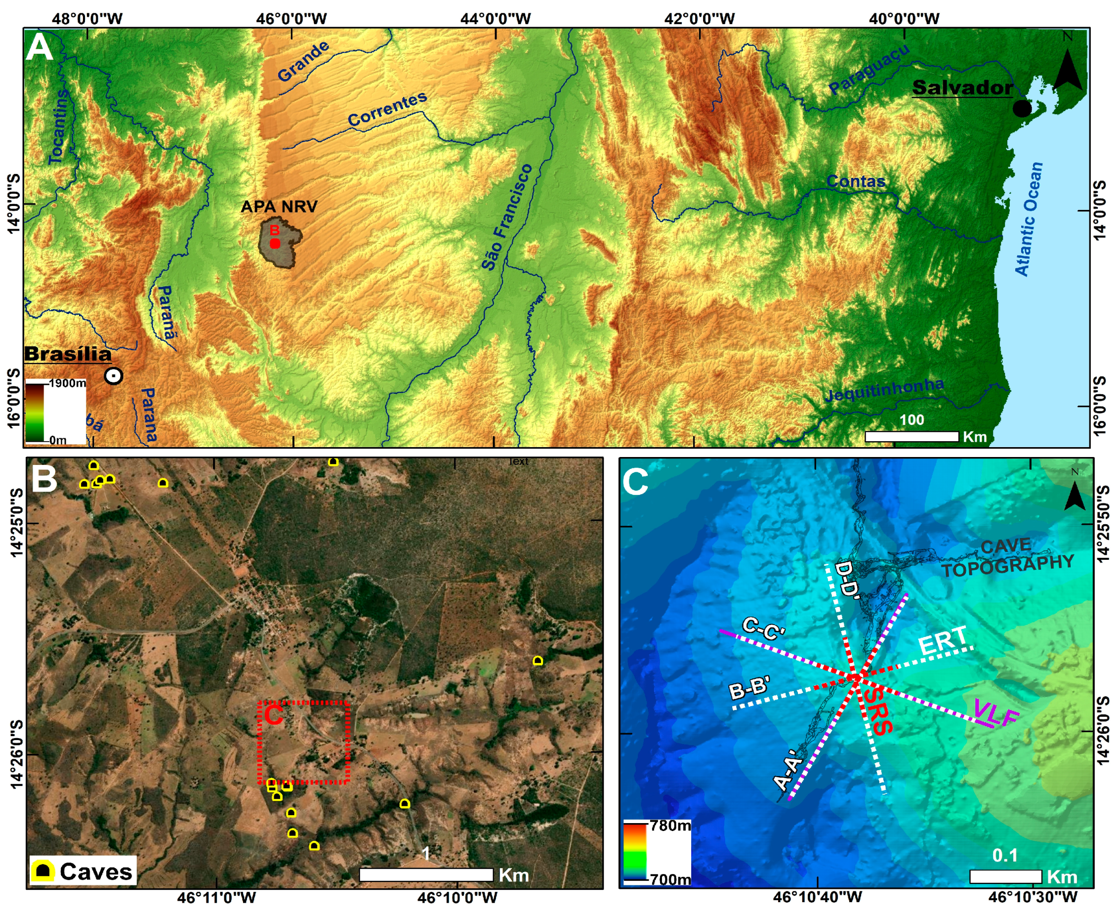
2.1. Study Area
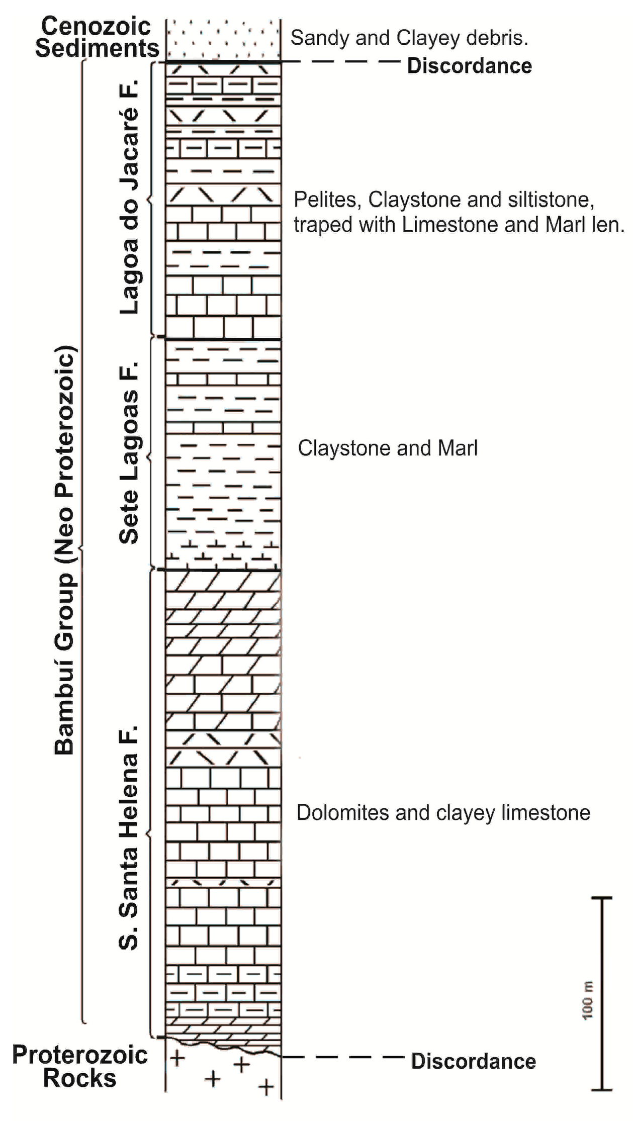
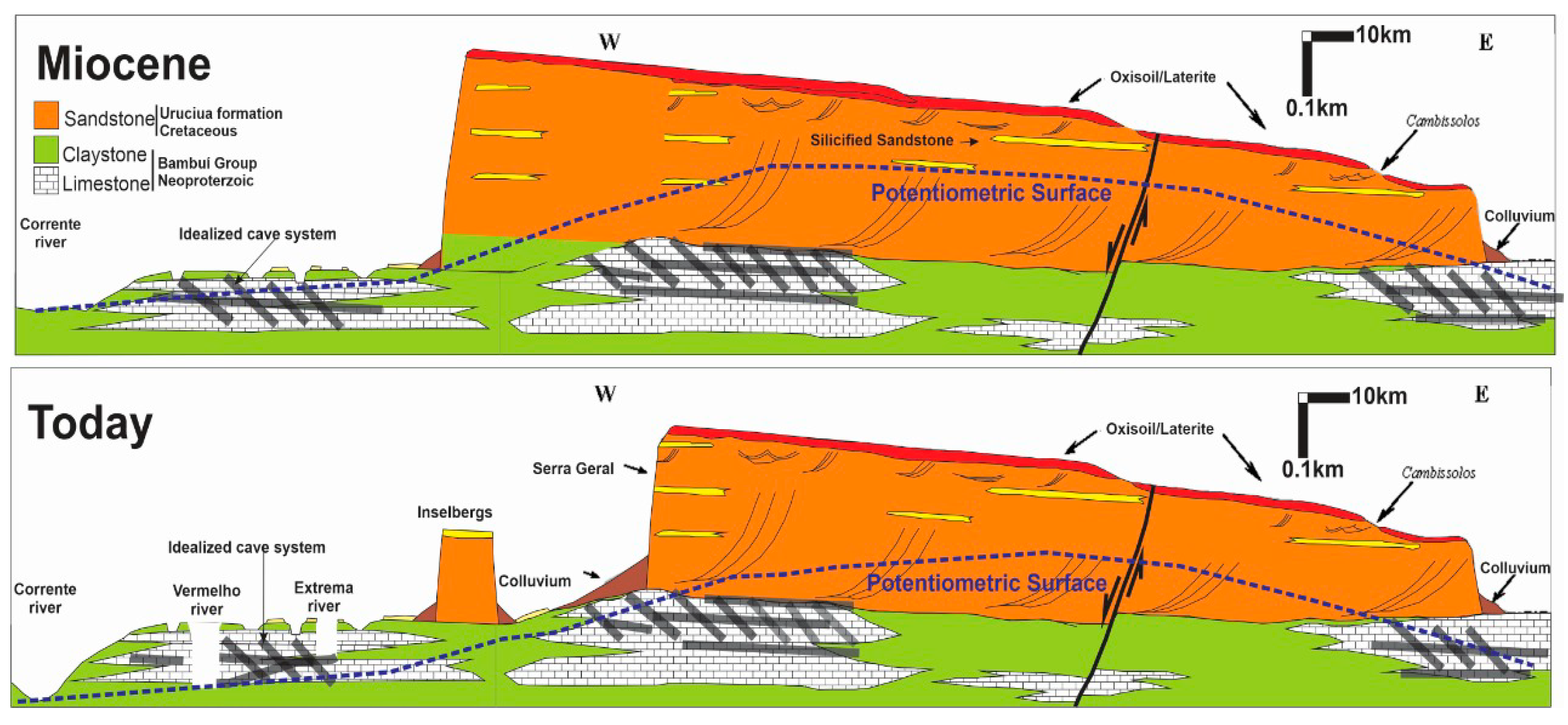
2.2. Geology and Geomorphology
2.3. Cover-Collapse Doline & Perched Aquifer
3. Methodology
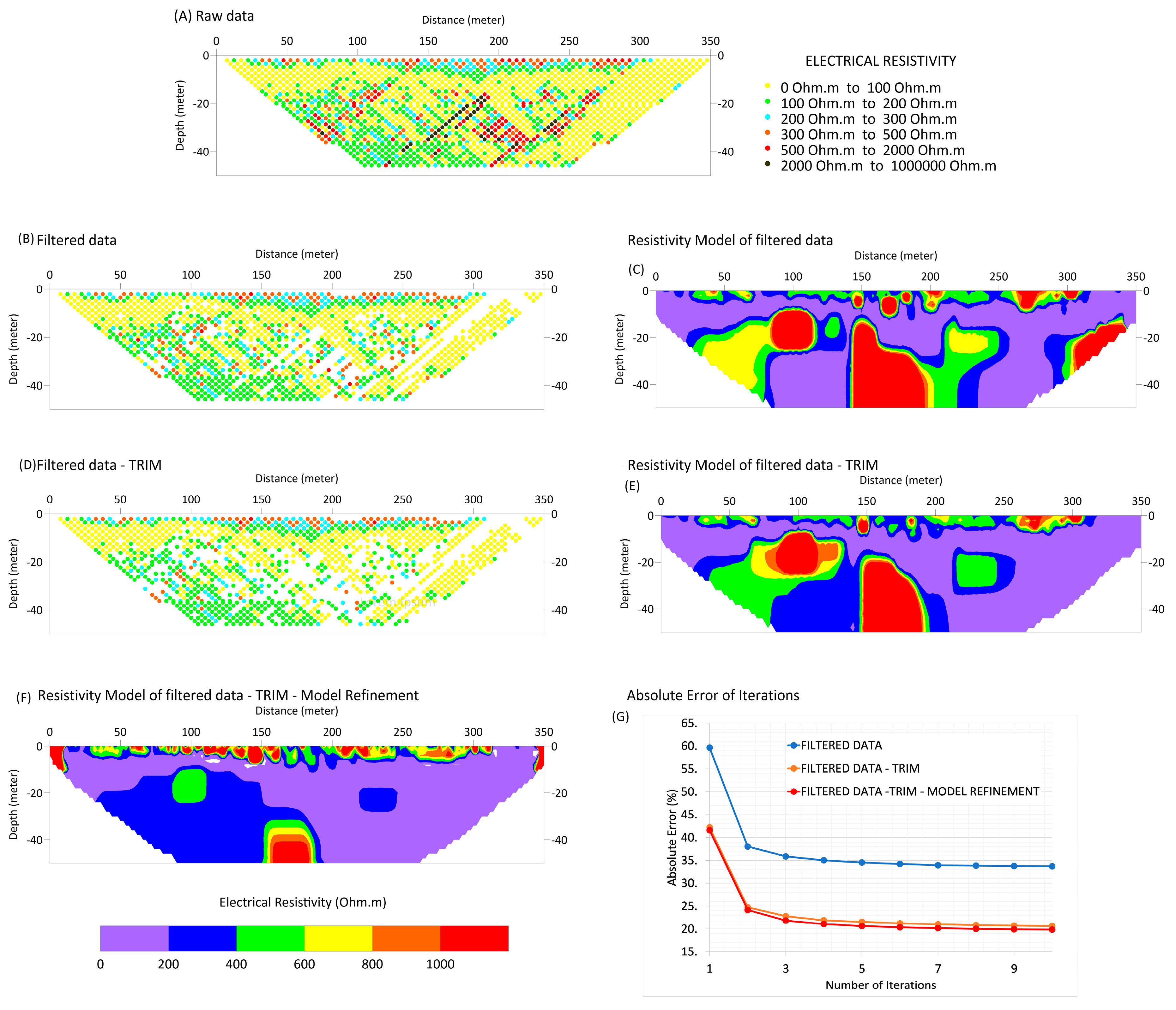
3.1. Electrical Resistivity Tomography (ERT)
3.2. Seismic Refraction Survey (SRS)
3.3. Very Low-Frequency Electromagnetic (VLF-EM)
4. Results, Analysis and Discussion
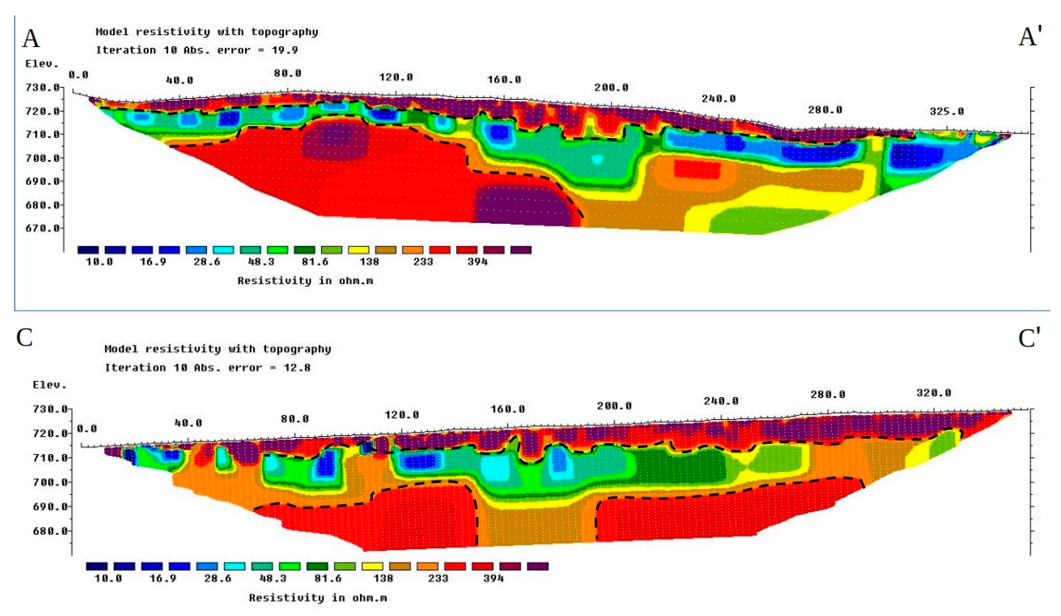
4.1. Electrical Resistivity Tomography (ERT)
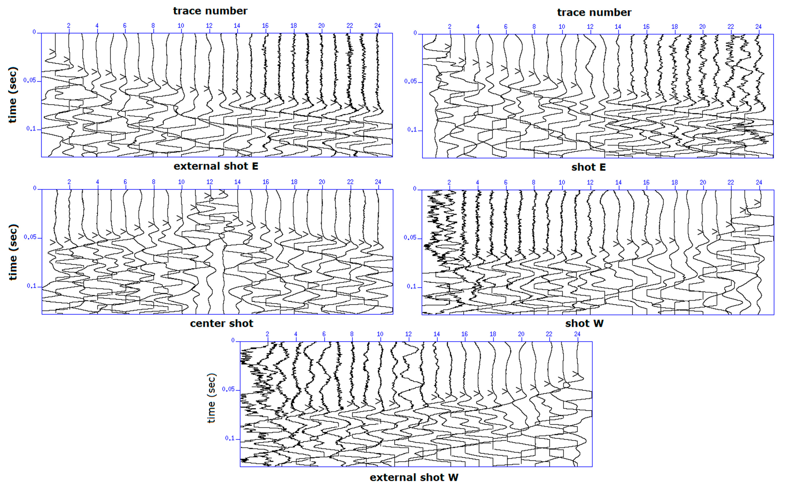
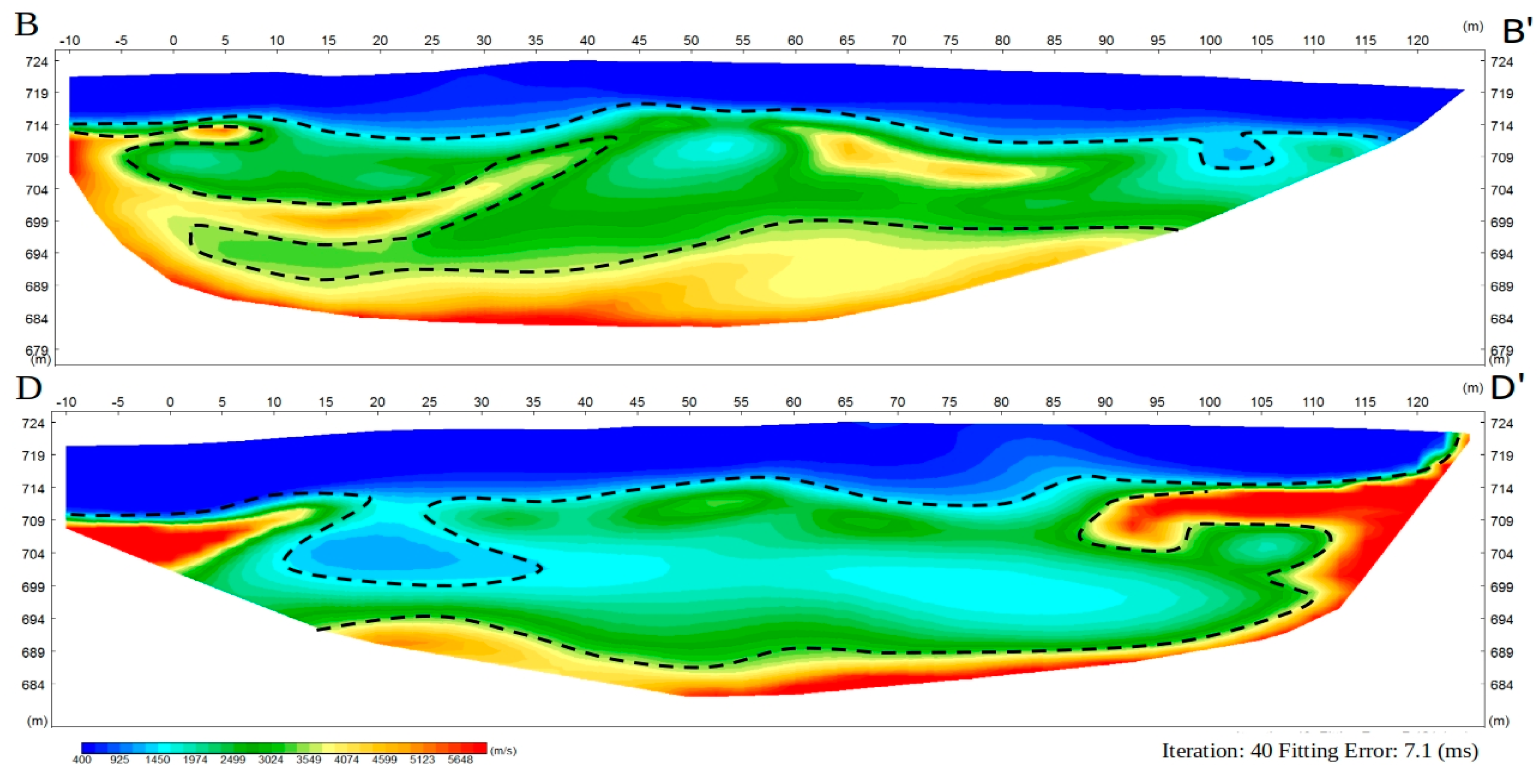
4.2. Seismic Refraction Survey (SRS)
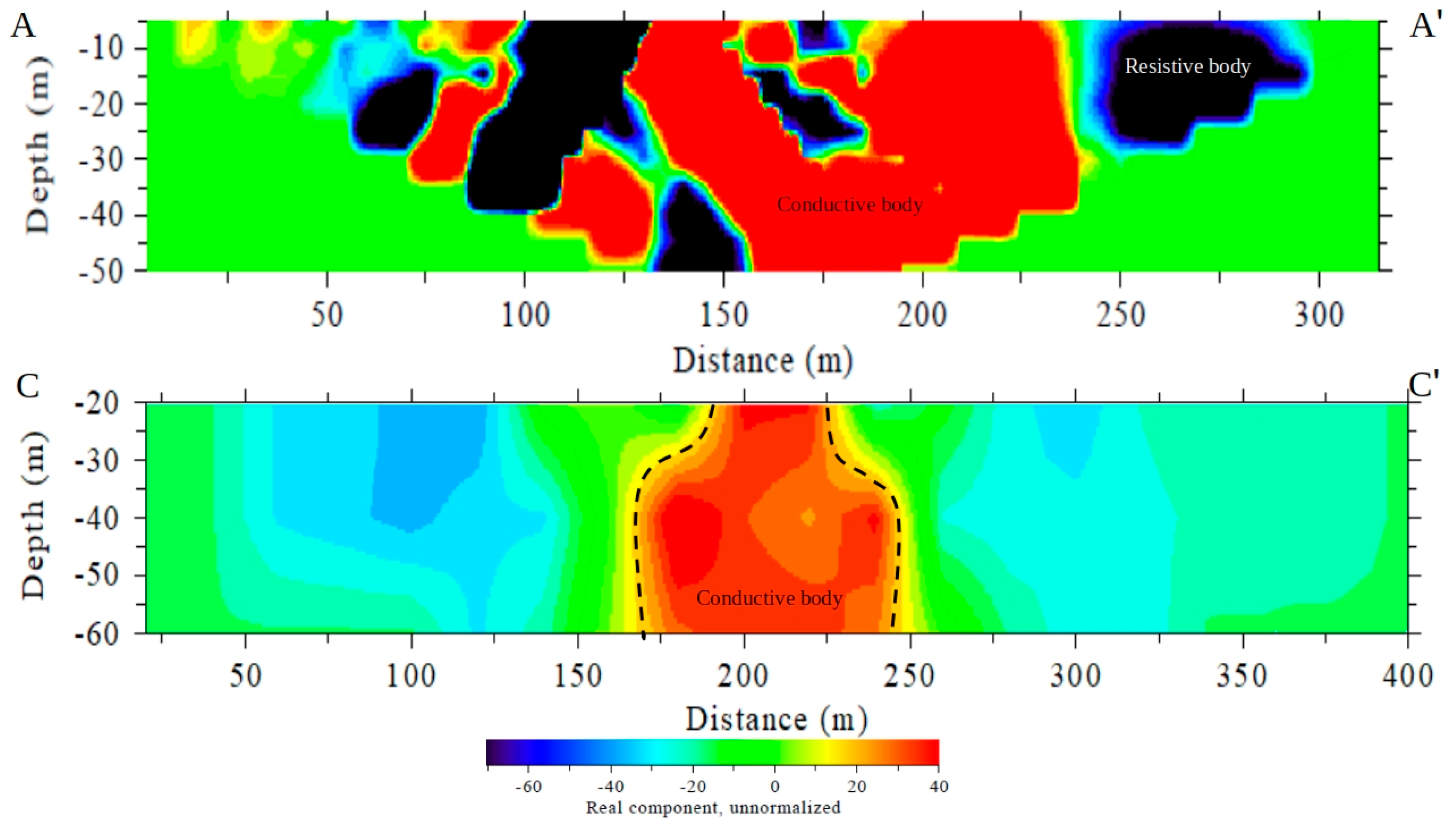
4.3. Very Low-Frequency Electromagnetic (VLF-EM)
5. Conclusions
Author Contributions
Funding
Acknowledgments
Conflicts of Interest
References
- Abidi, A.; Demehati, A.; Banouni, H.; El Qandil, M. The Importance of Underground Cavities Detection in the Choice of Constructible Areas: Case of the Agglomeration of Fez (Morocco); Springer: Berlin, Germany, 2018. [Google Scholar]
- Hussain, Y.; Uagoda, R.; Borges, W.; Nunes, J.; Hamza, O.; Condori, C.; Aslam, K.; Dou, J.; Cárdenas-Soto, M. The potential use of geophysical methods to identify cavities, sinkholes and pathways for water infiltration. Water 2020, 12, 2289. [Google Scholar] [CrossRef]
- Valois, R.; Camerlynck, C.; Dhemaied, A.; Guerin, R.; Hovhannissian, G.; Plagnes, V.; Robain, H. Assessment of doline geometry using geophysics on the Quercy plateau karst (South France). Earth Surf. Process. Landfor. 2011, 36, 1183–1192. [Google Scholar] [CrossRef]
- Kaufmann, G.; Romanov, D.; Nielbock, R. Cave detection using multiple geophysical methods: Unicorn cave, Harz Mountains, Germany. Geophysics 2011, 76, B71. [Google Scholar] [CrossRef]
- Mohamed, A.M.E.; El-Hussain, I.; Deif, A.; Araffa, S.A.S.; Mansour, K.; Al-Rawas, G. Integrated GPR, ERT and MASW for detecting near-surface caverns at Duqm area, Sultanate of Oman. Near Surf. Geophys. 2019, 17, 379–401. [Google Scholar] [CrossRef]
- Sundararajan, N.; Al-Wardi, M.; Raef, A. Integration of micro-gravity and very low frequency (VLF) electromagnetic (em) data analyses to outline hazardous cavities and low rock-strength: Coastal carbonates, Wadi Shab, Oman. In Proceedings of the Symposium on the Application of Geophysics to Engineering and Environmental Problems, Austin, TX, USA, 22–26 March 2015; pp. 147–152. [Google Scholar]
- Parise, M. Karst Geo-hazard: Causal factors and management issues. Acta Carsologica 2015, 44, 401–414. [Google Scholar] [CrossRef]
- Denizman, C.; Thieme, D.M. Karst within the confining unit of the Floridan Aquifer: A geophysical investigation. J. Geogr. Geol. 2015, 10. [Google Scholar] [CrossRef]
- Gutiérrez, F.; Parise, M.; de Waele, J.; Jourde, H. A review on natural and human-induced geohazards and impacts in karst. Earth Sci. Rev. 2014, 138, 61–88. [Google Scholar] [CrossRef]
- Martínez-Moreno, F.J.; Pedrera, A.; Ruano, P.; Galindo-Zaldívar, J.; Martos-Rosillo, S.; González-Castillo, L.; Marín-Lechado, C. Combined microgravity, electrical resistivity tomography and induced polarization to detect deeply buried caves: Algaidilla cave (Southern Spain). Eng. Geol. 2013, 162, 67–78. [Google Scholar] [CrossRef]
- Sundararajan, N.; Narasimhachary, M.; Nandakumar, G.; Srinivas, Y. VES and VLF an application to ground water exploration, Khammam, India. Lead. Edge 2007, 26, 708–716. [Google Scholar] [CrossRef]
- Chalikakis, K.; Plagnes, V.; Guerin, R.; Valois, R.; Bosch, F.P. Contribution of geophysical methods to karst-system exploration: An overview. Hydrogeol. J. 2011, 19, 1169. [Google Scholar] [CrossRef]
- Pazzi, V.; Ceccatelli, M.; Gracchi, T.; Masi, E.B.; Fanti, R. Assessing subsoil void hazards along a road system using H/V measurements, ERTs and IPTs to support local decision makers. Near Surf. Geophys. 2018, 16, 282–297. [Google Scholar] [CrossRef]
- Chalikakis, K. Geophysical Methods Applied to Water Exploration and Protection in Karst Environment. Ph.D. Thesis, Université Pierre et Marie Curie-Paris 6, Paris, France, 2006; p. 217. [Google Scholar]
- Ford, D.C.; Williams, P.W. Karst Geomorphology and Hydrology; Chapman and Hall: New York, NY, USA, 2007; p. 601. [Google Scholar]
- Oladotun, A.O.; Oluwagbemi, J.E.; Lola, A.M.; Maxwell, O.; Sayo, A. Predicting dynamic geotechnical parameters in near surface coastal environment. Cog. Eng. 2019, 6, 1588081. [Google Scholar] [CrossRef]
- Verdet, C.; Colette, S.; Antoine, M.; Joëlle, R.; Portais, J.C. Detection of undercover karst features by geophysics (ERT) Lascaux cave hill. Geomorphology 2020, 360, 107177. [Google Scholar] [CrossRef]
- Xiaojun, Z.; Huang, J.; Song, L.; Chen, Y. Application of Ground penetrating Radar (GPR) exploration in Karst mountain areas. In Proceedings of the XIII Internarional Conference on Ground Penetrating Radar, IEEE, Lecce, Italy, 21–25 June 2010; pp. 1–4. [Google Scholar]
- Solbakk, T.; Fichler, C.; Wheeler, W.H.; Lauritzen, S.E.; Ringrose, P. Detecting Multiscale Karst Features Including Hidden Caves Using Microgravimetry in a Caledonian Nappe Setting; Mefjell Massif: Norsk Geologisk Forening, Norway, 2018. [Google Scholar]
- Guérin, R.; Baltassat, J.M.; Boucher, M.; Chalikakis, K.; Galibert, P.Y.; Girard, J.F.; Plagnes, V.; Valois, R. Geophysical characterisation of karstic networks-application to the Ouysse system (Poumeyssen, France). C.R. Geosci. 2009, 341, 810–817. [Google Scholar] [CrossRef]
- Valois, R.; Bermejo, L.; Guérin, R.; Hinguant, S.; Pigeaud, R.; Rodet, J. Karstic morphologies identified with geophysics around Saulges caves (Mayenne, France). Archaeol. Prospect. 2010, 17, 151–160. [Google Scholar] [CrossRef]
- Billi, A.; de Filippis, L.; Poncia, P.P.; Sella, P.; Faccenna, C. Hidden sinkholes and karst cavities in the travertine plateau of a highly-populated geothermal seismic territory (Tivoli, central Italy). Geomorphology 2016, 255, 63–80. [Google Scholar] [CrossRef]
- Cueto, M.; Olona, J.; Fernández-Viejo, G.; Pando, L.; López-Fernández, C. Karst-induced sinkhole detection using an integrated geophysical survey: A case study along the Riyadh Metro Line 3 (Saudi Arabia). Near Surf. Geophys. 2018, 16, 270–281. [Google Scholar] [CrossRef]
- Chávez, R.E.; Tejero-Andrade, A.; Cifuentes, G.; Argote-Espino, D.L.; Hernández-Quintero, E. Karst detection beneath the pyramid of El Castillo, Chichen Itza, Mexico, by non-invasive ERT-3D methods. Sci. Rep. 2018, 8, 1–9. [Google Scholar] [CrossRef] [PubMed]
- Bermejo, L.; Ortega, A.I.; Guérin, R.; Benito-Calvo, A.; Pérez-González, A.; Parés, J.M.; Carbonell, E. 2D and 3D ERT imaging for identifying karst morphologies in the archaeological sites of Gran Dolina and Galería Complex (Sierra de Atapuerca, Burgos, Spain). Quat. Int. 2017, 433, 393–401. [Google Scholar] [CrossRef]
- Dos Santos, E.S.; Silva, R.W.; Sampaio, E.E. Analysis of the risk of karst collapse in Lapão, Bahia, Brazil. Explor. Geophys. 2012, 43, 198–212. [Google Scholar] [CrossRef]
- De Queiroz, S.L.; Galvão, P.; Leal, L.R.B.; de Araujo Pereira, R.G.F.; da Purificação, C.G.C.; Laureano, F.V. Evaluation of susceptibility for terrain collapse and subsidence in karst areas, municipality of Iraquara, Chapada Diamantina (BA), Brazil. Environ. Earth Sci. 2018, 77, 593. [Google Scholar] [CrossRef]
- Pereira, D.L.; Galvão, P.; Lucon, T.; Fujaco, M.A. Adapting the EPIK method to Brazilian Hydro (geo) logical context of the São Miguel watershed to assess karstic aquifer vulnerability to contamination. J. S. Am. Earth Sci. 2019, 90, 191–203. [Google Scholar] [CrossRef]
- Brandi, I.; Sebastião, C.S.; Ferreira, M.L.; Lima, H.M.D.; Gama, M.F.P. Physical stability of iron ore caves: Geomechanical studies of a shallow underground cave in SE Brazil. REM Int. Eng. J. 2019, 72, 217–225. [Google Scholar] [CrossRef]
- Garcia, G.P.; Grohmann, C.H. DEM-based geomorphological mapping and landforms characterization of a tropical karst environment in southeastern Brazil. J. S. Am. Earth Sci. 2019, 93, 14–22. [Google Scholar] [CrossRef]
- Maranhão, D.D.; Pereira, M.G.; Collier, L.S.; dos Anjos, L.H.; Azevedo, A.C.; de Souza Cavassani, R. Pedogenesis in a karst environment in the Cerrado biome, northern Brazil. Geoderma 2020, 365, 114169. [Google Scholar] [CrossRef]
- Lobo, H.A.S.; Bichuette, M.; Hardt, R.; de Souza Martinelli, R.; Bruno Filho, F.G.; Gallão, J.; Calvo, E.M. Preliminary Environmental Characterization and Conservation Proposal to Gruta da Tarimba Karst System—Goiás State, Brazil; Brazilian Society of Speleology: São Paulo, Brazil, 2015. [Google Scholar]
- Gaspar, M.T.P.; Campos, J.E.G.O. Sistema aquífero urucuia. Rev. Bras. Geociênc. 2007, 37, 216–226. [Google Scholar] [CrossRef]
- Bengala, C.V. Detalhamento da Geologia das Unidades Carbonáticas do Grupo Bambuí na Região de Alvorada do Norte, Goiás. Ph.D. Thesis, Universidade de Brasília, Brasília, Brasil, March 2012. [Google Scholar]
- Dardenne, M.A. Síntese sobre a estratigrafia do Grupo Bambuí no Brasil Central. SBG Congr. Bras. Geol. 1978, 2, 507–510. [Google Scholar]
- Iglesias, M.; Uhlein, A. Estratigrafia do grupo bambuí e coberturas fanerozoicas no vale do rio São Francisco, norte de Minas Gerais. Rev. Bras. Geociênc. 2009, 39, 256–266. [Google Scholar] [CrossRef]
- Waltham, T.; Waltham, A.C.; Bell, F.G.; Culshaw, M.G. Sinkholes and Subsidence: Karst and Cavernous Rocks in Engineering and Construction; Springer Science & Business Media: Berlin, Germany, 2005. [Google Scholar]
- Sinclair, W.C.; Stewart, J.W.; Knutilla, R.L.; Gilboy, A.E.; Miller, R.L. Types, Features, and Occurrence of Sinkholes in the Karst of West-Central Florida; US Geological Survey: Reston, VA, USA, 1985.
- Redhaounia, B.; Ilondo, B.O.; Gabtni, H.; Sami, K.; Bédir, M. Electrical resistivity tomography (ERT) applied to Karst carbonate aquifers: Case study from Amdoun, northwestern Tunisia. Pure Appl. Geophys. 2016, 173, 1289–1303. [Google Scholar] [CrossRef]
- Mitrofan, H.; Povară, I.; Mafteiu, M. Geoelectrical investigations by means of resistivity methods in karst areas in Romania. Environ. Geol. 2008, 55, 405–413. [Google Scholar] [CrossRef]
- El-Qady, G.; Hafez, M.; Abdalla, M.A.; Ushijima, K. Imaging subsurface cavities using geoelectric tomography and ground-penetrating radar. J. Cave Karst Stud. 2005, 67, 174–181. [Google Scholar]
- Kaufmann, O.; Deceuster, J. Detection and mapping of ghost-rock features in the Tournaisis area through geophysical methods—An overview. Geol. Belg. 2014, 17, 17–26. [Google Scholar]
- Gambetta, M.; Armadillo, E.; Carmisciano, C.; Stefanelli, P.; Cocchi, L.; Tontini, F.C. Determining geophysical properties of a near surface cave through integrated microgravity vertical gradient and electrical resistivity tomography measurements. J. Cave Karst Stud. 2011, 73, 11–15. [Google Scholar] [CrossRef]
- Pánek, T.; Šilhán, K.; Tábořík, P.; Hradecký, J.; Smolková, V.; Lenart, J.; Pazdur, A. Catastrophic slope failure and its origins: Case of the May 2010 Girová Mountain long-runout rockslide (Czech Republic). Geomorphology 2011, 130, 352–364. [Google Scholar] [CrossRef]
- Loke, M.H. Tutorial: 2-D and 3-D Electrical Imaging Surveys; Geotomo Software: Penang, Malasya, 2004. [Google Scholar]
- Sasaki, Y. Resolution of resistivity tomography inferred from numerical simulation. Geophys. Prospect. 1992, 54, 453–464. [Google Scholar] [CrossRef]
- Colangelo, G.; Lapenna, V.; Loperte, A.; Perrone, A.; Telesca, L. 2D electrical resistivity tomographies for investigating recent activation landslides in Basilicata Region (Southern Italy). Ann. Geophys. 2008, 51, 275–285. [Google Scholar]
- Lapenna, V.; Lorenzo, P.; Perrone, A.; Piscitelli, S.; Rizzo, E.; Sdao, F. 2D electrical resistivity imaging of some complex landslides in Lucanian Apennine chain, southern Italy. Geophysics 2005, 70, B11–B18. [Google Scholar] [CrossRef]
- Shebl, S.; Gemail, K.S.; Attwa, M.; Soliman, S.A.; Azab, A.; Farag, M.H. Utilizing shallow seismic refraction in defining the geotechnical properties of the foundation materials: A case study at New Minia City, Nile Valley, Egypt. Egypt. J. Pet. 2019, 28, 145–154. [Google Scholar] [CrossRef]
- Attwa, M.; El-Shinawi, A. An integrative approach for preliminary environmental engineering investigations amidst reclaiming desert-land: A case study at East Nile Delta, Egypt. Environ. Earth Sci. 2017, 76, 304. [Google Scholar] [CrossRef]
- McClymont, A.; Bauman, P.; Johnson, E.; Pankratow, L. Geophysical applications to construction engineering projects. CSEG Rec. 2016, 41, 4. [Google Scholar]
- Prekopová, M.; Janočko, J.; Budinský, V.; Friedmanová, M. Integration of seismic and sedimentological methods for analysis of Quaternary alluvial depositional systems. Environ. Earth Sci. 2017, 76, 25. [Google Scholar] [CrossRef]
- Shahrukh, M.; Soupios, P.; Papadopoulos, N.; Sarris, A. Geophysical investigations at the Istron archaeological site, eastern Crete, Greece using seismic refraction and electrical resistivity tomography. J. Geophys. Eng. 2012, 9, 749–760. [Google Scholar] [CrossRef]
- Brixová, B.; Mosná, A.; Putiška, R. Applications of shallow seismic refraction measurements in the Western Carpathians (Slovakia): Case studies. Contrib. Geophys. Geod. 2018, 48, 1–21. [Google Scholar] [CrossRef]
- Azwin, I.N.; Saad, R.; Nordiana, M. Applying the seismic refraction tomography for site characterization. APCBEE Proc. 2013, 5, 227–231. [Google Scholar] [CrossRef]
- Jug, J.; Grabar, K.; Strelec, S.; Dodigović, F. Investigation of dimension stone on the Island Brač-Geophysical approach to rock mass quality assessment. Geosciences 2020, 10, 112. [Google Scholar] [CrossRef]
- Hagedoorn, J.G. The plus-minus method of interpreting seismic refraction sections. Geophys. Prospect. 1959, 7, 158–182. [Google Scholar] [CrossRef]
- Babu, R.V.; Ram, S.; Sundararajan, N. Modeling and inversion of magnetic and VLF-EM data with an application to basement fractures: A case study from Raigarh, India. Geophysics 2007, 72, B133–B140. [Google Scholar] [CrossRef]
- Al-Tarazi, E.; Abu Rajab, J.; Al-Naqa, A.; El-Waheidi, M. Detecting leachate plumes and groundwater pollution at Ruseifa municipal landfill utilizing VLF-EM method. J. Appl. Geophys. 2008, 65, 121–131. [Google Scholar] [CrossRef]
- Poddar, M.; Rathor, B.S. VLF survey of the weathered layering southern India Geophys. Prospect 1983, 315, 24–37. [Google Scholar]
- Al-Oufi, A.; Mustafa, H.A.; Al-Tarazi, E.; Abu Rajab, J. Exploration of the extension of two lava tubes, faults and dikes using very low frequency-electromagnetic technique in NE Jordan. Acta Geophys. 2008, 56, 466–484. [Google Scholar] [CrossRef]
- Dindi, E. An assessment of the performance of the geophysical methods as a tool for the detection of zones of potential subsidence in the area southwest of Nakuru town, Kenya. Environ. Earth Sci. 2015, 73, 3643–3653. [Google Scholar] [CrossRef]
- Fraser, D.C. Contouring of VLF-EM data. Geophysics 1969, 34, 957–967. [Google Scholar] [CrossRef]
- Abdullahi, N.K.; Osazuwa, I.B. Geophysical imaging of municipal solid waste contaminant pathways. Environ. Earth Sci. 2011, 62, 1173–1181. [Google Scholar] [CrossRef]
- Ogilvy, R.D.; Lee, A.C. Interpretation of VLF-EM in-phase data using current density pseudosections 1. Geophys. Prospect. 1991, 39, 567–580. [Google Scholar] [CrossRef]
- Eluwole, A.B. An Interactive Manual on Qualitative and Computer Assisted Interpretation of Very Low Frequency Electromagnetic (VLF-EM) Data; Obafemi Awolowo University: Ife, Nigeria, 2012. [Google Scholar] [CrossRef]
- Hussain, Y.; Ullah, S.F.; Hussain, M.B.; Aslam, A.Q.; Akhter, G.; Martinez-Carvajal, H.; Cárdenas-Soto, M. Modelling the vulnerability of groundwater to contamination in an unconfined alluvial aquifer in Pakistan. Environ. Earth Sci. 2017, 76, 84. [Google Scholar] [CrossRef]


© 2020 by the authors. Licensee MDPI, Basel, Switzerland. This article is an open access article distributed under the terms and conditions of the Creative Commons Attribution (CC BY) license (http://creativecommons.org/licenses/by/4.0/).
Share and Cite
Hussain, Y.; Uagoda, R.; Borges, W.; Prado, R.; Hamza, O.; Cárdenas-Soto, M.; Havenith, H.-B.; Dou, J. Detection of Cover Collapse Doline and Other Epikarst Features by Multiple Geophysical Techniques, Case Study of Tarimba Cave, Brazil. Water 2020, 12, 2835. https://doi.org/10.3390/w12102835
Hussain Y, Uagoda R, Borges W, Prado R, Hamza O, Cárdenas-Soto M, Havenith H-B, Dou J. Detection of Cover Collapse Doline and Other Epikarst Features by Multiple Geophysical Techniques, Case Study of Tarimba Cave, Brazil. Water. 2020; 12(10):2835. https://doi.org/10.3390/w12102835
Chicago/Turabian StyleHussain, Yawar, Rogerio Uagoda, Welitom Borges, Renato Prado, Omar Hamza, Martín Cárdenas-Soto, Hans-Balder Havenith, and Jie Dou. 2020. "Detection of Cover Collapse Doline and Other Epikarst Features by Multiple Geophysical Techniques, Case Study of Tarimba Cave, Brazil" Water 12, no. 10: 2835. https://doi.org/10.3390/w12102835
APA StyleHussain, Y., Uagoda, R., Borges, W., Prado, R., Hamza, O., Cárdenas-Soto, M., Havenith, H.-B., & Dou, J. (2020). Detection of Cover Collapse Doline and Other Epikarst Features by Multiple Geophysical Techniques, Case Study of Tarimba Cave, Brazil. Water, 12(10), 2835. https://doi.org/10.3390/w12102835