Article

A Novel Crowdsourcing-Assisted 5G Wireless Signal Ranging Technique in MEC Architecture

by
Rui Lu
1,
Lei Shi
1,*,
Yinlong Liu
2,3,* and
Zhongkai Dang
1
1
National Computer Network Emergency Response Technical Team/Coordination Center of China, Beijing 100029, China
2
Institute of Information Engineering, Chinese Academy of Sciences, Beijing 100085, China
3
School of Cyber Security, University of Chinese Academy of Sciences, Beijing 100049, China
*
Authors to whom correspondence should be addressed.
Future Internet 2025, 17(5), 220; https://doi.org/10.3390/fi17050220
Submission received: 6 April 2025 / Revised: 2 May 2025 / Accepted: 8 May 2025 / Published: 14 May 2025

Abstract

:
In complex indoor and outdoor scenarios, traditional GPS-based ranging technology faces limitations in availability due to signal occlusion and user privacy issues. Wireless signal ranging technology based on 5G base stations has emerged as a potential alternative. However, existing methods are limited by low efficiency in constructing static signal databases, poor environmental adaptability, and high resource overhead, restricting their practical application. This paper proposes a 5G wireless signal ranging framework that integrates mobile edge computing (MEC) and crowdsourced intelligence to systematically address the aforementioned issues. This study designs a progressive solution by (1) building a crowdsourced data collection network, using mobile terminals equipped with GPS technology to automatically collect device signal features, replacing inefficient manual drive tests; (2) developing a progressive signal update algorithm that integrates real-time crowdsourced data and historical signals to optimize the signal fingerprint database in dynamic environments; (3) establishing an edge service architecture to offload signal matching and trajectory estimation tasks to MEC nodes, using lightweight computing engines to reduce the load on the core network. Experimental results demonstrate a mean positioning error of 5 m, with 95% of devices achieving errors within 10 m, as well as building and floor prediction error rates of 0.5% and 1%, respectively. The proposed framework outperforms traditional static methods by 3× in ranging accuracy while maintaining computational efficiency, achieving significant improvements in environmental adaptability and service scalability.

1. Introduction

In emerging fields such as smart cities and industrial Internet of Things (IoT), continuous and reliable ranging services have become fundamental in supporting key applications like autonomous driving and emergency response. However, existing ranging technologies face dual real-world constraints—first, in complex environments such as indoor parking lots, underground transportation hubs, and urban high-rise buildings, GPS signals frequently fail due to physical obstructions; second, user privacy protection policies lead to a large number of mobile devices actively disabling ranging features, further limiting the availability of traditional ranging solutions. Against this backdrop, with the commercialization of 5G networks and the widespread deployment of 5G base stations [1], how to leverage ubiquitous 5G base station networks to achieve GPS-independent or weak-GPS-dependent ranging services has become a focal point for both academia and industry.
Wireless signal ranging technology based on 5G signals estimates the distance of a terminal by analyzing the characteristics of base station signals, such as signal strength and phase, providing a potential solution to the aforementioned challenges. However, the practical deployment of this technology faces core challenges such as poor dynamic environmental adaptability and high operational and maintenance costs. This study proposes an innovative solution that integrates mobile edge computing (MEC) [2] and crowdsourcing intelligence [3], aiming to promote the evolution of high-precision ranging services toward low-cost and high-robustness directions.
Current research on base station-based wireless signal ranging mainly focuses on the following three areas: (1) constructing static signal databases based on professional equipment; (2) using machine learning algorithms to improve signal matching accuracy; (3) updating signal databases through periodic re-collection. However, the existing methods expose the following key flaws in engineering practice:
  • Data collection efficiency bottleneck: Traditional signal database construction relies on manual drive tests, which require professional teams to collect signal features point by point. In a scenario involving ultra-dense 5G networks, the reduced coverage of each base station dramatically increases the number of points to be collected, resulting in long data collection cycles and high costs, severely restricting the scalability of the technology.
  • Insufficient dynamic environmental adaptability: Existing static signal databases fail to adapt to dynamic changes in wireless signal propagation paths, leading to significant deviations in ranging results over time. Although some studies have attempted to introduce re-collection mechanisms, their high operational and maintenance costs are not sustainable.
  • Limited system scalability: Cloud-based signal matching architectures require terminal measurement data to be transmitted back to remote servers, increasing network latency. Additionally, schemes using complex AI models for incremental updates impose excessive demands on base station computational resources, making it difficult to support large-scale concurrent requests from terminals.
To address the above challenges, this paper proposes a 5G crowdsourced wireless signal ranging framework based on MEC. We first design a data collection mechanism driven by crowdsourcing intelligence, constructing a crowdsourced data collection network with user terminals participating collaboratively. Devices equipped with GPS functionality automatically collect device signal features and category labels during mobility. This mechanism breaks through the traditional manual drive test efficiency bottleneck and achieves continuous, low-cost signal data acquisition. Secondly, we deploy a lightweight signal update engine on the MEC server. By integrating crowdsourced data and historical signal features, we establish a dynamic signal fingerprint database that continuously optimizes the ranging reference data, significantly enhancing the ranging stability in complex scenarios. Finally, we offload computation tasks such as signal matching and trajectory estimation to the network edge nodes. Load balancing between MEC servers is achieved based on device locations. This strategy effectively reduces the data transmission pressure on the core network while leveraging edge computing resources to respond to terminal ranging requests in real-time.
Through the construction of a multi-base station collaborative testing environment, systematic comparative evaluation results show that—in GPS failure scenarios—the proposed solution significantly outperforms traditional static signal methods in terms of ranging accuracy. The dynamic update mechanism allows the system to maintain stable performance over long-term operation. The edge computing architecture demonstrates superior resource utilization efficiency in terminal-dense scenarios.
The main contributions of the current article are as follows:
  • A general 5G wireless signal ranging framework integrating crowdsourced perception and MEC architecture is proposed. For dynamic environmental characteristics, the framework can collaborate with multiple algorithms to achieve continuous optimization of the signal fingerprint database with low computational overhead. Through distributed data collection and edge computing, the framework systematically addresses the three major challenges, namely, data acquisition cost, environmental adaptability, and resource constraints.
  • A progressive signal fingerprint update algorithm is designed, enabling the autonomous evolution of ranging reference data in dynamic environments, overcoming the performance degradation bottleneck of traditional static models.
  • A lightweight edge-ranging service engine is developed to validate the effectiveness of the MEC architecture in reducing network load and improving service response speed, providing a feasible solution for the practical deployment of 5G base station-assisted ranging technology.
This paper is structured as follows: Section 2 provides a comprehensive literature review, discussing the latest research achievements in the field and analyzing the existing limitations and research gaps. Section 3 outlines our 5G crowdsourcing-assisted wireless signal ranging framework and its detailed components, highlighting the innovations of our approach and summarizing our original contributions to the field. Section 4 discusses the technical advantages of our solution in detail, showcasing the advantages of our approach. Section 5 presents our experimental validation process, including the experimental setup, configuration, and the results obtained. Section 6 is a detailed discussion of future work. Section 7 presents our conclusion, summarizing the advantages of the proposed solution and pointing out potential directions for future research.

2. Background and Related Work

2.1. Wireless Signal Ranging Technology

In environments where GPS devices are unavailable or signals are inaccessible, wireless signal ranging technologies offer a critical alternative for enabling location-based services. Devices such as low-power IoT sensors or simplified wearables may lack satellite modules due to hardware constraints or operate in areas with severe signal obstruction. To achieve positioning, current systems primarily employ three wireless methodologies, that is, base station-assisted ranging, Bluetooth, and LoRa. Among them, base station-assisted ranging serves as the primary solution for wide-area coverage, while Bluetooth and LoRa are deployed in specialized scenarios.

2.1.1. Base Station-Assisted Signal Ranging

Base station-assisted ranging leverages cellular infrastructure to provide localization over large areas. It primarily adopts three approaches based on signal characteristics, that is, time difference of arrival (TDOA), angle of arrival (AOA), and received signal strength indicator (RSSI/CSI)-based methods. TDOA determines device location by measuring signal arrival time differences at multiple base stations, constructing hyperbolic intersections, with accuracy dependent on clock synchronization. AOA estimates signal direction using antenna arrays, requiring measurements from at least two base stations for triangulation. RSSI/CSI-based methods utilize pre-built signal fingerprints, with deep learning techniques enabling sub-meter accuracy by extracting time–frequency features from channel state information in multipath environments.
Among these techniques, TDOA and AOA offer higher accuracy and stability in certain environments due to their independence from signal strength. For instance, Kim et al. introduced a TDOA algorithm that eliminates the need for base station synchronization by leveraging continuous positional changes of mobile sources, reducing the required packet count and validating performance through Monte Carlo simulations [4]. As mentioned in [5], based on the modified polar representation (MPR), TDOA localization can unify near-field and far-field processing, decouple angle and range estimation, and achieve near-optimal performance with low computational complexity. Nemati et al. examined the impact of base station topology on TDOA and AOA, highlighting TDOA’s reliance on high-precision synchronization and AOA’s lower base station count requirement, but more complex antenna design [6]. AOA, which measures signal arrival angles, is particularly effective in scenarios with closely spaced base stations. Xhafa et al. explored the combined use of UTDoA (uplink time difference of arrival) and AoA in 5G networks, along with base station selective exclusion, to enhance performance, especially in non-line-of-sight (NLoS) conditions [7]. Dong et al. proposed a multi-path communication mechanism for UWB indoor positioning, addressing clock asynchrony by utilizing multi-path propagation to improve accuracy while reducing synchronization dependency [8]. These techniques demonstrate distinct strengths in various applications. For example, TDOA and its variants excel in high-precision scenarios, while AOA is more suitable in dense base station deployments with moderate angle measurement requirements. In modern communication networks, RSSI-based, base station-assisted signal ranging has become a critical research area. Numerous studies have been conducted in this domain. For example, Lutakamale et al. constructed a signal strength-to-location database and applied convolutional neural networks (CNNs) with squeeze-and-excitation (SE) blocks to improve localization accuracy [9]. Ding et al. proposed a hybrid localization method, combining RSS and angle of arrival (AOA) measurements to overcome the limitations of RSS-only positioning under heterogeneous anchor conditions [10]. Using a two-stage linear weighted least squares (LWLS) estimator, their approach mitigates measurement noise inconsistencies, enhancing robustness and accuracy. Meanwhile, deep learning has been employed to model complex RSS patterns. Karakusak et al. demonstrated that architectures such as MLP, CNN, and LSTM can effectively learn spatial and temporal features from WLAN RSS data [11], with LSTM networks excelling in dynamic tracking scenarios. Beyond deep learning, feature transformation and adaptive neighbor selection have improved traditional methods. An RSS-transform-based weighted k-nearest neighbor (Q-WKNN) algorithm [12] was introduced, using cardinality transformations and adaptive parameter selection to better handle signal variability. Finally, hybrid measurement fusion continues to advance. A recent study combined RSS and AOA to enhance localization in non-line-of-sight (NLOS) environments [13], demonstrating that integrating complementary modalities improves resilience to multipath and shadowing effects.

2.1.2. Bluetooth-Assisted Signal Ranging

Bluetooth technology, with its low power consumption and high deployment density, enables meter-level signal ranging in indoor environments. Its methods primarily include triangulation, scene analysis, and proximity.
Triangulation offers the highest precision by calculating device coordinates based on distances to at least three known Bluetooth nodes, typically using RSSI or time-of-flight (TOF) measurements. Environmental interference may cause errors, requiring algorithmic corrections. Scene analysis matches real-time Bluetooth signal measurements to a pre-established fingerprint database, enabling robust localization in complex environments but demanding comprehensive and accurate radio maps. Proximity estimation, the simplest approach, infers relative distance based on signal strength thresholds without providing precise coordinates, making it suitable for applications requiring only approximate location information. Bluetooth-assisted signal ranging has been widely explored in indoor localization research due to its accessibility and low power consumption. Recent studies have further advanced Bluetooth-based positioning by incorporating deep learning models and hybrid fingerprinting strategies, achieving sub-3-meter accuracy even in dynamic environments [14,15]. Beyond pure learning-based approaches, several works have investigated hybrid systems to enhance BLE localization performance. Li et al. proposed a fusion of Bluetooth Low Energy (BLE) and ultra-wideband (UWB) signals, employing regression to significantly improve positioning robustness in complex indoor environments [16]. Complementing this, Gollner et al. introduced a lightweight BLE fingerprinting solution based on beacon calibration and smartwatch integration, targeting practical room-level tracking with minimal infrastructure [17]. In parallel, there has been a growing focus on improving the interpretability of BLE localization. Rodríguez et al. presented an explainable machine learning framework that leverages RSSI measurements to enhance model transparency and user trust in sensitive applications [18]. Performance optimization from a system design perspective has also been explored. Milano et al. systematically evaluated BLE signal processing techniques, identifying strategies such as refined RSSI filtering and optimized anchor placement to maximize positioning accuracy [19]. Furthermore, adaptive fingerprinting methods have been proposed to address environmental dynamics. Ruan et al. developed a dynamic fingerprint window approach (DFW-WKNN), adjusting the search space in real-time based on environmental context, thereby boosting localization precision in large-scale settings [20]. Overall, the recent trajectory of Bluetooth-assisted localization research reflects an integrated evolution—from traditional signal-based methods toward hybrid, learning-augmented, interpretable, and adaptive systems, aiming to meet the growing demands for accuracy, scalability, and robustness in dynamic indoor environments. Despite these improvements, Bluetooth-assisted localization still faces significant challenges, including sensitivity to multipath and non-line-of-sight conditions, limited scalability in large deployments, increased positioning latency in dense networks, and vulnerability to signal spoofing attacks, all of which hinder its broader adoption in mission-critical scenarios.

2.1.3. LoRa-Assisted Signal Ranging

LoRa (long range)-assisted signal ranging, a low-power wide-area network (LPWAN)-based solution, addresses the demand for coarse-grained localization in scenarios such as wild asset tracking and agricultural monitoring, leveraging kilometer-level signal propagation and ultra-low power consumption. Device ranging primarily involves analyzing signal characteristics such as received signal strength (RSSI), propagation time, and phase variations. The physical layer properties of LoRa, including chirp spread spectrum (CSS) modulation and sub-GHz ISM band operation, provide strong penetration and high link budgets, making it suitable for challenging environments.
However, significant challenges persist. LoRa signals tend to degrade below noise levels after penetrating obstacles, adversely impacting RSSI- and TDOA-based localization methods. Furthermore, the narrowband nature of LoRa limits the sharpness of time-domain waveforms, restricting the achievable performance of time-of-arrival (TOA) techniques [21]. Recent efforts have sought to overcome these challenges. Hirotsu et al. proposed an improved RSSI-based LoRa localization system for drones by integrating sensor-derived altitude data and employing Huber loss in multilateration, significantly enhancing localization accuracy in both simulation and real-world settings [22]. Yahya et al. developed a compact, machine learning-optimized wearable monopole antenna for LoRa tracking, which improved RSSI performance by 3 dBm and maintained high efficiency even under bending, advancing LoRa-based wearable localization [23]. Islam et al. introduced an unsupervised symbolization approach for outdoor LoRa localization, leveraging maximum entropy partitioning and D-Markov machines to eliminate the need for offline training and adapt to dynamic environments [24]. Lin et al. proposed SyncLoc, a TDoA-based LoRa localization framework that corrects gateway time drift at the nanosecond level, achieving over 2× the accuracy and scalability improvements in multi-node concurrent localization [25]. Lam et al. designed a series of RSSI-based algorithms for large-scale LoRa localization, focusing on mitigating Gaussian and non-Gaussian noise effects, and demonstrated that their system can achieve performance comparable to GPS in outdoor scenarios [26]. Chen et al. developed a mobile-anchor-based multi-target outdoor localization scheme that optimizes path planning to minimize anchor movement while maintaining signal ranging accuracy, thereby effectively reducing energy consumption in large outdoor deployments [27]. These works collectively demonstrate that enhancing signal processing, hardware design, synchronization accuracy, and learning algorithms are key strategies to overcome the inherent challenges of LoRa-based localization in diverse applications.
Despite these advancements, LoRa-assisted localization remains best suited for low-precision, wide-area applications due to inherent limitations in accuracy and deployment density, particularly when compared to base station-assisted solutions.
In contrast to base station-assisted signal ranging technology, Bluetooth-assisted signal ranging is confined to short-range device localization and cannot address the demands of large-scale or wide-area deployments. Meanwhile, LoRa-assisted signal ranging, constrained by its sparse deployment, is primarily applicable to low-precision scenarios such as agricultural monitoring and logistics tracking, with limited adaptability. Given the high-density deployment of 5G base stations, this study focuses on base station-assisted signal ranging technology, which enables refined signal ranging services in complex urban environments and overcomes the coverage limitations inherent to traditional short-range communication technologies.

2.2. Environment Perception Fingerprint Collection

This section outlines the traditional street-scanning method for environmental perception fingerprint collection and introduces a grid-based approach to address the challenges in data acquisition.

2.2.1. Traditional Street Scanning Method

The traditional environment perception fingerprint acquisition method usually adopts the street scanning method, that is, to scan the signal ranging device and collect the wireless signal characteristics at each environment perception in the target area. This method requires a professional surveyor to remain at each environment perception for a period of time to ensure that a comprehensive wireless signal signature is gathered. However, due to the heavy workload and time-consuming nature of the process, this approach often struggles to achieve comprehensive data acquisition in practice, especially over large areas.

2.2.2. Grid-Based Street Scanning Method

To address the aforementioned challenges, researchers have proposed grid-based street-scanning methodologies to enhance the efficiency of fingerprint acquisition. Grid-based street-scanning is a systematic data collection technique that partitions target areas into grid cells, enabling detailed reference point data collection within each grid to ensure comprehensiveness and consistency. Recent research has explored diverse strategies to optimize grid design, data collection, and signal processing. Wang et al. proposed a fine-grained grid computing model for Wi-Fi indoor localization in complex environments, where subdividing the area into smaller grid cells and leveraging signal strength features combined with machine learning significantly enhanced localization accuracy and robustness [28]. Kim et al. proposed an irregular grid map approach for large-scale Wi-Fi fingerprinting, where reference points are placed at the centers of uneven grid cells to enhance coverage and minimize localization errors [29]. Building upon systematic grid partitioning, Zhang et al. introduced a method based on RSSI fingerprint feature vectors, dividing the target environment into uniform grids and achieving 2–4 m localization accuracy by matching real-time RSSI measurements [30]. Khattak et al. further improved grid-based fingerprinting by applying a bag-of-features machine learning framework, employing k-means clustering and k-nearest neighbors to robustly model and match WLAN RSS fingerprints [31].
The above main research summaries on wireless signal ranging and fingerprinting can be summarized as shown in Table 1. However, these grid-based signal ranging schemes lack real-time fingerprint map updates and overlook matching latency in large-scale user environments. To overcome these limitations, this paper proposes a progressive fingerprint update algorithm that integrates real-time crowdsourced data with historical fingerprints via a spatiotemporal correlation model, enabling autonomous optimization of reference databases in dynamic environments. This approach bridges the gap in existing grid-based fingerprint collection methodologies. Furthermore, by innovatively leveraging mobile edge computing (MEC) architecture combined with lightweight computational engines, the scheme significantly reduces core network load while maintaining high-precision localization performance.

3. Solution Design

We constructed a multi-layer collaborative 5G wireless signal ranging framework based on mobile edge computing (MEC) [32] and crowdsourcing intelligence [33], as shown in Figure 1. This framework dynamically collects environmental data through the terminal perception layer, optimizes ranging services in real time through the edge computing layer, and coordinates resources globally through the cloud coordination layer, forming a closed-loop intelligent positioning system. It breaks through the static bottleneck of traditional architectures, relies on crowdsourcing intelligence for low-cost data acquisition, combines edge computing for dynamic incremental updates to the fingerprint database, and strikes a balance between privacy protection and computational efficiency, meeting the real-time ranging demands in complex 5G scenarios.
Specifically, the framework is divided into three layers—the cloud coordination layer manages the dynamic signal fingerprint database and global collaborative optimization, maintaining the reference model and dynamically adjusting the collaboration between MEC nodes. The edge computing layer serves as the core hub, deploying a lightweight ranging service and incremental signal fingerprint update engine with multi-algorithm collaboration, achieving cross-node load balancing through dynamic task scheduling. The terminal perception layer constructs a crowdsourced data collection network, and through encrypted transmission and policy adjustment mechanisms, transforms a large number of mobile devices into environmental perception units.

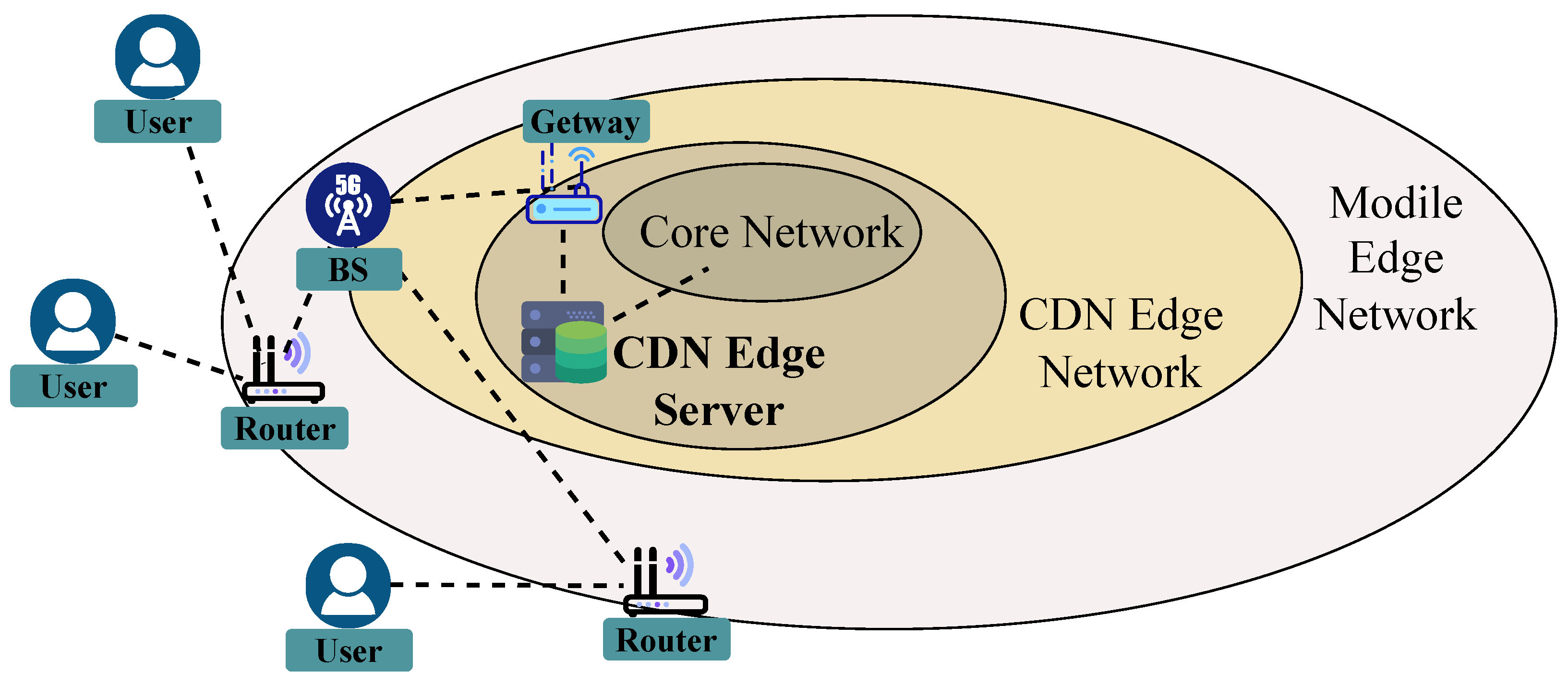
3.1. Mobile Network Edge Deployment

In the 5G wireless signal ranging framework, mobile network edge deployment is a core component for achieving low-latency, high-efficiency, and high-precision ranging services. By offloading computational tasks from the core network to MEC (mobile edge computing) servers close to the users, the latency in the ranging process can be significantly reduced, and system resource usage can be optimized to meet the real-time ranging demands in dynamic environments.
First, the design requires the reasonable deployment of MEC servers. These servers should cover multiple key points within the target area, especially areas with high base station density and complex signal environments. Each MEC server must possess powerful computational capacity and storage capacity to support real-time signal data processing and dynamic updating and optimization of the signal fingerprint database. In addition, efficient collaboration between different MEC nodes is necessary to ensure data sharing and collaborative computing, improving the overall system’s response speed and accuracy.
Next, terminal devices collect and upload signal data by connecting to the nearest MEC server. User equipment not only collects wireless signal features, such as signal strength and phase information, but also provides other relevant information about the device. By transmitting the data to the MEC server, the system can perform real-time analysis and computation using edge computing capabilities, reducing dependency on remote servers and the core network, thus alleviating the network burden and improving the real-time performance of the ranging system. Even in environments where GPS is unavailable or signals are limited, the system can still collect signal data using network-based indirect inference methods, ensuring the system’s high availability in various environments.
In terms of data processing, the system adopts an incremental update mechanism. Whenever new data are uploaded from the terminal to the MEC node, the edge computing platform dynamically updates the fingerprint database based on the new signal features. This progressive update method effectively avoids the high cost and low efficiency problems associated with traditional static signal database updates, and it can better adapt to environmental changes, such as variations in base station density or user behavior. Let S i represent the signal features at the i-th collection point, and let F ( t ) represent the signal fingerprint database at time t. The new fingerprint database F ( t + 1 ) can be dynamically updated using Equation (1):
F ( t + 1 ) = F ( t ) + α · Δ F ( t )
where Δ F ( t ) represents the increment of the new signal features collected at time t, and α is a parameter that controls the update rate. Through this incremental update mechanism, the system can real-time optimize the fingerprint database based on newly collected data, avoiding the need for full re-collection and the high computational overhead associated with traditional methods.
In the actual ranging process, the accuracy of signal matching is crucial for the system’s performance. To accurately match signal features and estimate the device’s distance, we adopt a weighted matching method based on signal strength and propagation models. Let d i represent the distance between the i-th device and the base station, and P i represent the signal strength received by the device. The relationship between signal strength and distance can be calculated using Equation (2):
P i = P 0 10 n log 10 ( d i ) + X σ
where P 0 is the reference signal strength, n is the path loss exponent, and X σ is Gaussian noise with zero mean and variance σ 2 . The system can estimate the distance between the device and the base station based on the received signal strength, thereby performing signal fingerprint matching and updating.
Finally, to further optimize computational efficiency, the system adopts a parallel processing mechanism. In the MEC servers, computational resources are dynamically allocated through task scheduling, distributing signal data processing tasks across multiple nodes. The optimization of task scheduling can be expressed using Equation (3):
T t o t a l = i = 1 N T i · C i C m a x
where T t o t a l is the total computation time, T i is the computation task time for the i-th node, C i is the computation capability of the i-th node, and C m a x is the maximum computation capability of all nodes. With this approach, the system can efficiently allocate tasks, ensuring that the computational resources of each MEC node are fully utilized, thereby improving the system’s response speed and processing efficiency.
In the 5G wireless signal ranging process, the user’s environmental sensing data and personal information must be adequately protected to prevent potential data leakage or privacy infringement risks. Therefore, the design incorporates measures such as data encryption, identity authentication, and access control to ensure the security and privacy of user information, especially when sensitive data are being transmitted. The schematic of edge deployment for environmental sensing is shown in Figure 2.
The edge deployment architecture implements privacy protection through three layers:
  • Device layer: Data are encrypted during transmission through routers and base stations (BS).
  • Edge layer: CDN edge servers perform identity verification and control data access rights via gateways.
  • Core layer: The core network only receives processed non-sensitive data.

3.2. Main Modules of the Environment Perception Server

The environmental sensing server is a core component of the 5G wireless signal ranging system. It is responsible for handling signal data requests from terminal devices, managing the signal fingerprint database, and performing signal processing and optimization algorithms. The main modules of the environmental sensing server are as follows:
Environmental sensing request management module: This module is responsible for receiving and managing signal data requests from user devices. It communicates with user devices, receives the signal data requests, and processes them. The module also handles prioritizing, scheduling, and dispatching requests to appropriate computing modules for processing. To achieve efficient request scheduling, the priority of each request, P r e q , is determined, which can be sorted based on the urgency or signal quality of the request:
P r e q = 1 T p r o c e s s · α + β · Signal Quality
where T p r o c e s s is the preprocessing time for each request, and α and β are tuning parameters that control the impact of urgency and signal quality on the priority. This formula helps dynamically optimize the scheduling order of requests, thereby improving response speed.
Signal fingerprint database management module: This module is responsible for managing the database that stores wireless signal fingerprints. The signal fingerprint database contains environmental signal feature data uploaded by user devices, including base station signal strength, phase information, etc. To achieve efficient storage and fast querying, the signal fingerprint database is optimized using indexing methods. For any signal fingerprint F ( t ) and query signal Q, the matching similarity Sim ( F , Q ) can be calculated using cosine similarity:
Sim ( F , Q ) = F ( t ) · Q F ( t ) Q
Signal processing and matching algorithm module: This module is responsible for executing the signal processing and matching algorithms used for wireless signal ranging. When signal data from terminal devices is received, the signal processing and matching algorithm module processes the data, including signal feature extraction, noise reduction, and feature matching calculations. The goal is to accurately estimate the device’s distance or position by matching the data with the signal fingerprints stored in the database.
Data processing and analysis module: This module is used to process and analyze the environmental data collected through crowdsourcing. It optimizes the signal fingerprint database, detects outliers in the signal data, and updates the signal fingerprint features. Environmental modeling is performed based on historical and real-time data to provide more accurate parameter inputs for subsequent signal matching algorithms.
Environmental sensing service management module: This module is used to manage the configuration and operational status of the environmental sensing server. It monitors the health status of the server, as well as handles server startup and shutdown, configuration updates, and performance evaluation. It coordinates with MEC nodes and other system modules to support the real-time deployment and management of wireless signal ranging services.

3.3. Workflow for UE Environment Perception

The UE (user equipment) environmental sensing workflow is a key process in the 5G wireless signal ranging system for obtaining and processing the environmental information of user devices. The workflow pseudocode is shown in Algorithm 1:
Algorithm 1: UE environmental sensing workflow
Input: UE_ID, S F (Signal Features)
Output: R (Response)
Step 1: Send sensing req.     Send_Req(UE_ID, S F )
Step 2: Signal coll.     S = { Wi-Fi ,   Cellular ,   Bluetooth , } , Coll_Sig ( S )
Step 3: Signal up.    Send_Data( S UE_ID)
Step 4: Env. sensing match.    DB (Fingerprint Database),
  DB = Pre_col. Fingerprints, Match(S, DB), MS = Comp_Sim(S, DB)
Step 5: Signal proc.     S p = Sig_Proc ( S ) , S f = Noise_Red ( S p )
Step 6: Env. sensing resp.     R = Gen_Resp ( S f ) , Send_Resp(UE_ID, R)
Step 7: Env. sensing update.     Upd_Sig(UE_ID) if Trig_Cond
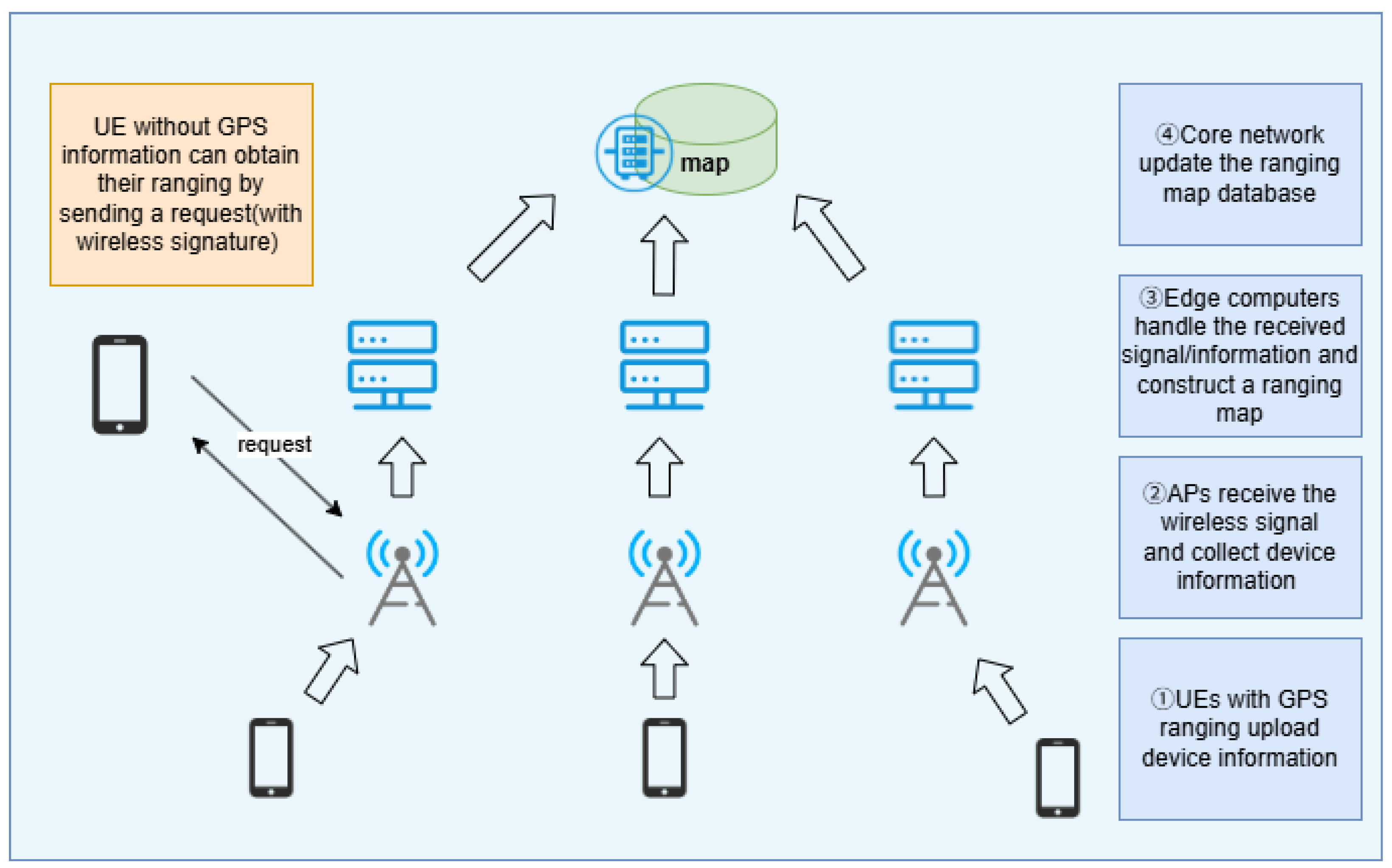
The workflow achieves controllable complexity through multi-stage optimization strategies. In terms of computational complexity, the signal matching phase employs a hierarchical retrieval mechanism. The coarse matching stage narrows the search space by leveraging the spatial clustering characteristics of signal features, while the fine matching stage enhances positioning accuracy through millimeter-wave multipath resolution. This divide-and-conquer approach effectively reduces the computational burden of global search. Communication overhead is optimized via feature dimensionality reduction techniques, where only essential feature vectors are transmitted after preprocessing raw high-dimensional signal data at edge nodes. The dynamic update mechanism adopts a difference-driven triggering strategy, activating fingerprint database updates only when environmental changes exceed predefined thresholds, thereby avoiding unnecessary computational resource consumption. Furthermore, the distributed architecture of edge nodes supports high-concurrency requests through parallel processing, ensuring algorithmic scalability in ultra-dense deployment scenarios.
Through this workflow, the system can effectively collect, transmit, and analyze wireless signal features, thereby achieving accurate environmental sensing. The main steps of the UE environmental sensing workflow are as follows:
  • Environmental sensing request.
    UE first sends an environmental sensing request to the environmental sensing server. The request includes the UE’s device ID and the wireless signal features of the current environment (such as signal strength, frequency, delay, etc.), which serve as the basis for subsequent signal matching and analysis computations. Through this request, UE informs the environmental sensing server of the current data collection needs and device status, ensuring that the system can process the signal data accordingly.
  • Wireless signal collection.
    UE starts to collect wireless signal features from the current environment according to the environmental sensing server’s requirements. The wireless signal features include important parameters such as Wi-Fi, cellular network, Bluetooth signal strength, frequency, and delay. UE uses its wireless module to collect multiple signal data in real time from the environment, providing necessary input for subsequent environmental sensing analysis.
  • Signal upload.
    UE uploads the collected wireless signal features to the environmental sensing server via the network. The uploaded data includes the collected signal features, device ID, and other related information, which will be used as input for further environmental sensing analysis. During the upload process, the signal features and other environmental information are transmitted to the server, ensuring the system can utilize this information for subsequent calculations.
  • Environmental sensing matching.
    After receiving UE’s environmental sensing request and wireless signal features, the environmental sensing server performs a matching analysis using the pre-built signal fingerprint database. The server compares the wireless signal features uploaded by the UE with the signal features already collected in the database, using a matching algorithm to find the most similar signal feature sets. This process ensures that the system can accurately identify the environmental characteristics based on the signal data, thus providing support for environmental sensing calculations.
  • Signal analysis and processing.
    After environmental sensing matching, the environmental sensing server performs further analysis and processing on the matched signal feature data. Using signal processing algorithms, the system extracts key environmental information from the matched data and optimizes it. This stage of processing includes not only signal strength matching but also the application of signal attenuation models, noise filtering, etc. This process ensures that the most representative environmental information is extracted from a large volume of signal data for subsequent analysis.
  • Environmental sensing response.
    After completing signal matching and analysis processing, the environmental sensing server returns the calculated results as a response to the UE. This response includes the environmental sensing information of UE’s current environment, such as the trend of signal strength changes, environmental interference levels, and the number of available signal sources. The specific environmental sensing data will be customized according to the system design to meet the needs of different scenarios.
  • Environmental sensing update.
    To maintain the timeliness and accuracy of the data, UE can periodically update its collected environmental signal feature data based on the requirements of the environmental sensing server. The environmental sensing update mechanism ensures that the system maintains high data processing efficiency in a dynamically changing environment and can adapt to new network conditions or user demands. UE actively collects new signal features based on trigger conditions or preset time intervals and uploads them to the environmental sensing server for analysis and updating.
An overview of the UE environmental sensing workflow is shown in Figure 3:

4. Technical Advantages of Our Solution

This section presents a 5G wireless signal ranging solution based on mobile edge computing (MEC) and crowdsourcing technology, aiming to overcome the challenges in efficiency, real-time performance, and adaptability faced by traditional signal ranging methods. By introducing 5G millimeter-wave technology, offloading computation tasks to MEC nodes, and utilizing crowdsourced data collection, we have achieved the following three major innovations:

4.1. Efficient Signal Fingerprint Database Construction and Dynamic Updating Mechanism

Traditional methods of signal fingerprint database construction often rely on professional personnel for manual data collection, resulting in long data update cycles and low efficiency. To improve the efficiency of constructing the fingerprint database, this solution introduces a crowdsourcing data collection method that leverages wireless signal features, device information, and environmental sensing data from user equipment. By deploying environmental sensing services on MEC servers, the system can efficiently collect and integrate large amounts of user data in near real-time, enabling high-speed fingerprint database construction and dynamic updating. The system continuously optimizes the fingerprint database based on real-time data from user devices, adapting to changes in network conditions and user behaviors, thus avoiding the lag in updates associated with traditional methods.

4.2. Mobile Edge Computing (MEC) Accelerating Signal Processing and Real-Time Ranging

One of the core innovations of this solution is offloading signal processing tasks to MEC servers, which use the low-latency and high-bandwidth edge computing capabilities to process signal data and perform real-time ranging computations. Unlike traditional centralized computing models, MEC places computation tasks on edge nodes close to the users, significantly reducing signal processing latency and improving the real-time performance of ranging. MEC not only alleviates the computational burden on the core network but also optimizes resource scheduling and load balancing, ensuring the system operates efficiently in complex environments. Especially in 5G ultra-dense network scenarios, MEC better supports the concurrent ranging demands of large-scale devices, enhancing overall system response speed and accuracy.

4.3. High-Precision Ranging Based on 5G Millimeter-Wave Technology

Fifth-generation (5G) millimeter-wave technology offers higher frequency wireless signals that enable more accurate ranging. This solution fully utilizes the high bandwidth and low latency characteristics of 5G millimeter-wave technology, enhancing the precision of signal collection, especially in complex indoor or urban environments. Millimeter-wave signals are more sensitive to signal attenuation, but their high frequency also provides more usable information, which better meets the needs of high-precision ranging. By combining millimeter-wave signals with the powerful computing capabilities of MEC, the system can accurately calculate the distance between devices and base stations, significantly improving the accuracy of signal matching and ranging.

5. Experimental Verification and Results

5.1. Experimental Setup

In this study, we selected a region characterized by a complex and dynamically changing wireless signal environment as the experimental scenario. The experimental setup is shown in Figure 4. During the experiments, we deployed multiple mobile edge computing (MEC) servers near user devices to process uploaded data, provide environmental sensing services, and construct and update fingerprint maps. The study involved numerous participants using mobile devices for crowdsourced data collection. By installing a custom-developed mobile application, participants uploaded various wireless data features to the MEC servers, including environmental sensing information, wireless signal characteristics, and device metadata.
The wireless signal features encompassed RSSI (received signal strength indicator), CSI (channel state information), ToA (time of arrival), and AP topological relationships. Environmental sensing information incorporated data from built-in device sensors, such as barometric pressure (with an accuracy of 0.2 hPa), geomagnetic intensity (0.1 µT accuracy), ambient illuminance (ranging from 0 to 100,000 lux), and acoustic features (16–20 kHz frequency range). Additionally, devices equipped with GPS were required to upload precise ranging information to support fingerprint map construction and updates.
In validation experiments, we tested target devices without GPS functionality. These devices had known environmental sensing parameters and wireless signal characteristics, but unknown precise signal ranging. By placing these devices at predefined environmental sensing points with pre-recorded ground-truth coordinates, we applied the proposed signal ranging scheme and compared the perception results with actual measurements to evaluate the system’s accuracy and performance. The experiment workflow of our framework is depicted in Figure 5, which illustrates the overall workflow of our framework, consisting of an offline fingerprint map training phase and an online target matching phase. In the offline phase, location data, wireless signal characteristics, and device information from UEs are preprocessed to build a fingerprint map compatible with various machine learning algorithms. In the online phase, the system matches incoming signals from target UEs with the fingerprint map to output positioning results in real time.

5.2. Framework Performance Analysis

This study proposes a generalized crowdsourced wireless sensing framework for 5G base stations, which requires universal algorithms capable of achieving robust performance under diverse implementations. To validate the framework’s versatility, we integrated three fingerprint-matching algorithms—k-nearest neighbors (KNN), decision trees, and random forests—into our system.
The KNN algorithm operates on distance-based principles. Its core mechanism involves calculating distances (e.g., Euclidean, Manhattan, or cosine distances) between the target sample and training samples, selecting the k-nearest neighbors, and determining predictions through majority voting for classification tasks (e.g., floor identification) or averaging neighbor values for regression tasks (e.g., coordinate estimation).
Decision trees recursively select optimal features for node splitting using metrics like information gain or Gini index, constructing hierarchical decision rules. From root to leaf nodes, each path represents a decision sequence, with leaf nodes storing the final predicted location information.
Random forest, an ensemble method, enhances accuracy by aggregating predictions from multiple decision trees. It employs bootstrap sampling for tree diversity and random feature selection during node splitting. Final predictions are derived from majority voting (for classification) or averaging (for regression) across all trees.
To ensure fair comparison and reproducibility, we adopted commonly used hyperparameter settings for each algorithm based on prior work and empirical tuning on the UJIIndoorLoc dataset. For the k-nearest neighbors (kNN) model, we used a neighbor size k = 3 with Euclidean distance as the similarity metric. The decision tree model was configured with a maximum depth of 20 and a minimum of 5 samples per leaf to balance model complexity and overfitting. For random forest, we employed 200 estimators with a maximum depth of 25, using the default Gini impurity as the splitting criterion.
For simulation validation, we utilized the UJIIndoorLoc dataset—a publicly available indoor WiFi fingerprint dataset from Universitat Jaume I, Spain—due to the absence of existing 5G base station sensing datasets. Collected by over 20 users across three buildings using 25 devices, this dataset contains 19,938 training samples. As shown in Table 2, each sample includes signal strength measurements from 520 access points, along with ground-truth coordinates, building, and floor information, providing a robust basis for framework evaluation.
In the validation experiments, we assessed the positioning performance of various methods through four key metrics—building prediction error rate, floor prediction error rate, mean signal ranging error, and probability of coordinate error within 10 meters.
The building prediction error rate quantifies how frequently the system misidentifies the user’s building—for instance, incorrectly assigning a user in Building A to Building B—which directly reflects its ability to discern spatial boundaries in multi-building environments like campuses or shopping malls. The mathematical formation is as follows:
BER = 1 N i = 1 N I b ^ i b i
where b i is the ground-truth building label and b ^ i is the predicted building label for the i-th sample, and I ( · ) is the indicator function.
The floor prediction error rate measures vertical misjudgments, such as predicting Floor 2 or 4 when the user is on Floor 3, highlighting the system’s sensitivity to vertical cues like barometric pressure or multi-floor signal variations. The mathematical formation is as follows:
FER = 1 N i = 1 N I f ^ i f i
where f i and f ^ i denote the true and predicted floor labels, respectively.
The mean signal ranging error represents the average Euclidean distance between estimated coordinates (2D or 3D) and ground-truth locations across all test samples, providing a holistic view of spatial accuracy. The mathematical formation is as follows:
MSRE = 1 N i = 1 N p ^ i p i 2
where p i is the ground-truth position and p ^ i is the estimated position of the i-th sample.
Lastly, the probability of a coordinate error within 10 m evaluates the system’s reliability by calculating the percentage of samples with errors 10 m. The mathematical formation is as follows:
P 10 = 1 N i = 1 N I p ^ i p i 2 10
This metric indicates the proportion of samples for which the positioning error does not exceed 10 m. This indicator offers an intuitive and application-relevant perspective—rather than reporting only a mean signal ranging error, it directly reflects the likelihood that a user’s estimated position falls within a practically usable zone, as required by typical venue navigation and location-based services. The choice of a 10 m threshold aligns with common benchmarks in public indoor positioning evaluations, such as the Microsoft Indoor Localization Competition [34], EVARILOS benchmarking framework [35], and ISO/IEC 18305 standard [36]. Together with the building-scale, floor-level, and absolute-error statistics discussed above, this metric provides a comprehensive and interpretable characterization of system performance across both spatial and application-specific dimensions.

5.3. Results Analysis

Based on the validation experiment results shown in Figure 6 and Table 3, we analyzed the performance of the proposed MEC-based crowdsourced fingerprint environmental sensing framework. The key findings and observations include the following:
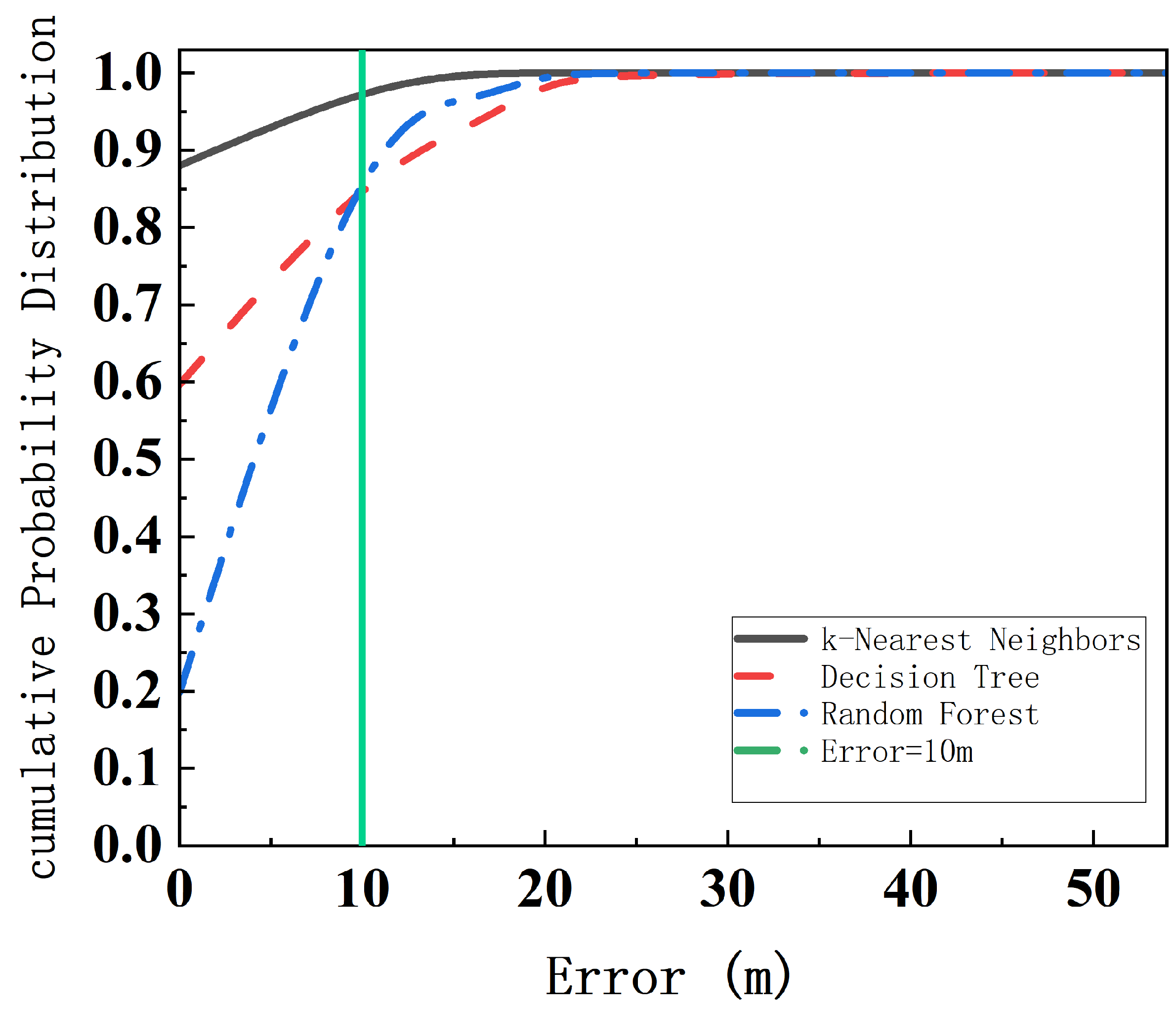
  • Perception accuracy: By comparing the system’s outputs with ground-truth environmental sensing data from target devices, we evaluated localization accuracy. For the three integrated algorithms, the building prediction error rate remained below 0.5%, while the floor prediction error rate was approximately 1%. The system achieved a mean positioning error of less than 5 m, with around 95% of devices demonstrating errors within 10 m. These results confirm the high localization precision of the proposed framework under most conditions, underscoring the effectiveness of the MEC and crowdsourcing-based approach.
  • Real-time capability: By uploading environmental sensing data from user devices to MEC servers, the framework enabled real-time localization and dynamic fingerprint map updates. Experimental results demonstrated that the system completes environmental sensing processes and updates fingerprint maps efficiently, providing a robust foundation for real-time tracking applications.
  • Operational efficiency: Leveraging crowdsourcing for data collection significantly reduced the workload of professional surveyors while enhancing data collection efficiency. Participants seamlessly contributed environmental sensing and device metadata, enabling continuous fingerprint map construction and updates. This distributed data collection approach aligns well with the rapid development and widespread adoption of 5G networks.
In summary, the validation experiments demonstrate that the proposed MEC-based crowdsourced fingerprint environmental sensing framework achieves high perception accuracy, real-time responsiveness, and operational efficiency.

6. Future Work

In future work, we will aim to further improve the adaptability and robustness of the proposed 5G signal ranging framework by extending it in three key directions. First, we plan to incorporate additional multimodal sensing data (e.g., inertial sensors, barometric pressure) to enhance trajectory continuity and vertical floor discrimination in complex indoor environments. Second, we will explore adaptive federated learning strategies at MEC nodes to enable real-time model personalization for different users and scenarios, while preserving data privacy. Third, large-scale field deployments across diverse urban regions will be conducted to validate scalability, cross-region transferability, and long-term stability under realistic operational constraints. These enhancements are crucial for moving toward truly autonomous and privacy-preserving location services.

7. Conclusions

This paper proposes a crowdsourced fingerprint signal ranging framework that integrates mobile edge computing (MEC) and swarm intelligence to address the limitations of traditional 5G fingerprint-based signal ranging technologies in terms of dynamic environment adaptability, data collection efficiency, and resource overhead—systematically resolving the challenges of providing reliable ranging services in complex scenarios. By designing a swarm intelligence-driven crowdsourced data collection network, GPS-enabled mobile terminals autonomously collect base station signal characteristics during movement, effectively replacing the inefficient manual drive-testing paradigm. This innovation significantly reduces data acquisition and operational costs while overcoming efficiency bottlenecks in ultra-dense network deployment.
Building on this foundation, we developed a progressive fingerprint update algorithm that dynamically optimizes signal ranging reference data by fusing real-time crowdsourced inputs with historical fingerprint databases. Experimental results demonstrate that this mechanism achieves a building prediction error rate below 0.5% and a floor prediction error rate of approximately 1%. It effectively mitigates performance degradation over long-term operation and substantially improves signal ranging accuracy in GPS-denied environments, achieving a mean positioning error of less than 5 m, with 95% of devices demonstrating errors within 10 m. These metrics outperform traditional static methods in environmental adaptability and stability. Furthermore, through an edge-centric service architecture, fingerprint matching and trajectory estimation tasks are offloaded to MEC nodes. Combined with a lightweight computing engine, the system dramatically reduces core network transmission loads, efficiently leverages edge computing resources in dense terminal scenarios, and enhances service responsiveness and scalability.
Validation experiments confirm that the framework achieves systemic breakthroughs in data collection cost, environmental adaptability, and service scalability through the co-design of crowdsourced data collection, dynamic fingerprint database updates, and edge-centric service architecture. The proposed framework completes environmental sensing processes within sub-second latency and updates fingerprint maps incrementally, demonstrating real-time capability that is essential for mission-critical applications. This work provides a practical solution for deploying 5G base station-assisted signal ranging technologies, advancing the real-world implementation of high-precision, GPS-independent localization services in dynamic and complex environments.

Author Contributions

Conceptualization, R.L. and L.S.; methodology, R.L.; software, Y.L.; validation, L.S., Y.L., and Z.D.; formal analysis, L.S.; investigation, Y.L.; resources, Z.D.; data curation, L.S.; writing—original draft preparation, R.L.; writing—review and editing, Y.L.; visualization, L.S.; supervision, Y.L. All authors have read and agreed to the published version of the manuscript.

Funding

This research received no external funding.

Data Availability Statement

‘UJIIndoorLoc dataset’ at https://archive.ics.uci.edu/dataset/310/ujiindoorloc (accessed on 5 April 2025).

Conflicts of Interest

The authors declare no conflicts of interest.

Abbreviations

The following abbreviations are used in this manuscript:
5Gfifth-generation mobile network
AIartificial intelligence
IoTInternet of Things
GPSglobal positioning system
MECmobile edge computing
TDOAtime difference of arrival
AOAangle of arrival
RSSIreceived signal strength indicator
CSIchannel state information
MPRmodified polar representation
CNNconvolutional neural network
LSTMlong short-term memory
MLPmultilayer perceptron
UWBultra-wideband
UEuser equipment
CDNcontent delivery network
BLEBluetooth Low Energy
CSSchirp spread spectrum
ToAtime-of-arrival
KNNk-nearest neighbors

References

  1. Wen, M.; Li, Q.; Kim, K.J.; López-Pérez, D.; Dobre, O.A.; Poor, H.V.; Popovski, P.; Tsiftsis, T.A. Private 5G networks: Concepts, architectures, and research landscape. IEEE J. Sel. Top. Signal Process. 2021, 16, 7–25. [Google Scholar] [CrossRef]
  2. Wang, X.; Li, J.; Ning, Z.; Song, Q.; Guo, L.; Guo, S.; Obaidat, M.S. Wireless powered mobile edge computing networks: A survey. ACM Comput. Surv. 2023, 55, 1–37. [Google Scholar] [CrossRef]
  3. Tang, J.; Liu, G.; Pan, Q. A review on representative swarm intelligence algorithms for solving optimization problems: Applications and trends. IEEE/CAA J. Autom. Sin. 2021, 8, 1627–1643. [Google Scholar] [CrossRef]
  4. Kim, S.; Chong, J.W. An efficient TDOA-based localization algorithm without synchronization between base stations. Int. J. Distrib. Sens. Netw. 2015, 11, 832351. [Google Scholar] [CrossRef]
  5. Sun, Y.; Ho, K.; Xing, T.; Yang, Y.; Chen, L. Projection-based algorithm and performance analysis for TDOA localization in MPR. IEEE Trans. Signal Process. 2024, 72, 896–911. [Google Scholar] [CrossRef]
  6. Nemati, M.; Baykas, T.; Choi, J. Performance of TDOA and AOA localization techniques for different base-stations topologies. In Proceedings of the 2019 13th International Conference on Signal Processing and Communication Systems (ICSPCS), Gold Coast, Australia, 16–18 December 2019; pp. 1–7. [Google Scholar]
  7. Xhafa, A.; del Peral-Rosado, J.A.; López-Salcedo, J.A.; Seco-Granados, G. Evaluation of 5G positioning performance based on UTDoA, AoA and base-station selective exclusion. Sensors 2021, 22, 101. [Google Scholar] [CrossRef]
  8. Dong, Y.; Lu, X.; Guo, J.; Peng, F. TDOA-MCM: A TDOA-based Multi-path Communication Mechanism for UWB Indoor Positioning. KSII Trans. Internet Inf. Syst. (TIIS) 2025, 19, 327–343. [Google Scholar]
  9. Lutakamale, A.S.; Myburgh, H.C.; De Freitas, A. RSSI-based fingerprint localization in LoRaWAN networks using CNNs with squeeze and excitation blocks. Ad Hoc Netw. 2024, 159, 103486. [Google Scholar] [CrossRef]
  10. Ding, W.; Li, L.; Chang, S. A Simple and Efficient Method for RSS-AOA-Based Localization with Heterogeneous Anchor Nodes. Sensors 2025, 25, 2028. [Google Scholar] [CrossRef]
  11. Karakusak, M.Z.; Kivrak, H.; Ates, H.F.; Ozdemir, M.K. RSS-based wireless LAN indoor localization and tracking using deep architectures. Big Data Cogn. Comput. 2022, 6, 84. [Google Scholar] [CrossRef]
  12. Zhou, R.; Yang, Y.; Chen, P. An RSS transform—Based WKNN for indoor positioning. Sensors 2021, 21, 5685. [Google Scholar] [CrossRef] [PubMed]
  13. Wang, Y.; Fu, J.; Wu, Z. A novel indoor precise positioning method based on RSS and AOA hybrid measurements. In Journal of Physics: Conference Series; IOP Publishing: Bristol, UK, 2024; Volume 2770, p. 012027. [Google Scholar]
  14. Wu, Z.; Hu, P.; Liu, S.; Pang, T. Attention mechanism and LSTM network for fingerprint-based indoor location system. Sensors 2024, 24, 1398. [Google Scholar] [CrossRef] [PubMed]
  15. Yoon, J.H.; Kim, H.J.; Lee, D.S.; Kwon, S.K. Indoor Positioning Method by CNN-LSTM of Continuous Received Signal Strength Indicator. Electronics 2024, 13, 4518. [Google Scholar] [CrossRef]
  16. Li, P.; Guan, R.; Chen, B.; Xu, S.; Xiao, D.; Xu, L.; Yan, B. UWB-Assisted Bluetooth Localization Using Regression Models and Multi-Scan Processing. Sensors 2024, 24, 6492. [Google Scholar] [CrossRef]
  17. Bouse, L.; King, S.A.; Chu, T. Simplified indoor localization using bluetooth beacons and received signal strength fingerprinting with smartwatch. Sensors 2024, 24, 2088. [Google Scholar] [CrossRef]
  18. Kamal, A.; Alam, M.G.R.; Hassan, M.R.; Apon, T.S.; Hassan, M.M. Explainable indoor localization of BLE devices through RSSI using recursive continuous wavelet transformation and XGBoost classifier. Future Gener. Comput. Syst. 2023, 141, 230–242. [Google Scholar] [CrossRef]
  19. Milano, F.; da Rocha, H.; Laracca, M.; Ferrigno, L.; Espírito Santo, A.; Salvado, J.; Paciello, V. BLE-based indoor localization: Analysis of some solutions for performance improvement. Sensors 2024, 24, 376. [Google Scholar] [CrossRef] [PubMed]
  20. Ruan, L.; Zhang, L.; Zhou, T.; Long, Y. An improved Bluetooth indoor positioning method using dynamic fingerprint window. Sensors 2020, 20, 7269. [Google Scholar] [CrossRef]
  21. Gu, C.; Jiang, L.; Tan, R. LoRa-based localization: Opportunities and challenges. arXiv 2018, arXiv:1812.11481. [Google Scholar]
  22. Hirotsu, K.; Granelli, F.; Nakao, A. Lora-based localization for drones: Methodological enhancements explored through simulations and real-world experiments. IEEE Access 2024, 12, 145988–145996. [Google Scholar] [CrossRef]
  23. Yahya, M.S.; Soeung, S.; Rahim, S.K.A.; Geok, T.K.; Musa, U. Machine Learning-Optimized Wearable Antenna for LoRa Localization. IEEE Access 2024, 12, 139237–139252. [Google Scholar] [CrossRef]
  24. Islam, K.Z.; Murray, D.; Diepeveen, D.; Jones, M.G.; Sohel, F. LoRa-based outdoor localization and tracking using unsupervised symbolization. Internet Things 2024, 25, 101016. [Google Scholar] [CrossRef]
  25. Lin, J.; Xiong, R.; Xu, Z.; Tian, W.; Chen, C.; Dong, X.; Luo, J. Multi-node concurrent Localization in LoRa networks: Optimizing accuracy and efficiency. In Proceedings of the IEEE INFOCOM 2024-IEEE Conference on Computer Communications, Vancouver, BC, Canada, 20–23 May 2024; pp. 1091–1100. [Google Scholar]
  26. Lam, K.H.; Cheung, C.C.; Lee, W.C. RSSI-based LoRa localization systems for large-scale indoor and outdoor environments. IEEE Trans. Veh. Technol. 2019, 68, 11778–11791. [Google Scholar] [CrossRef]
  27. Chen, H.; Xing, F.; Yang, Q.; Shu, Y.; Shi, Z.; Chen, J.; Tao, Z. A lightweight mobile-anchor-based multi-target outdoor localization scheme using LoRa communication. IEEE Trans. Green Commun. Netw. 2023, 7, 1607–1619. [Google Scholar] [CrossRef]
  28. Liang, Y.; Chen, S.; Dong, X.; Liu, T. Fine-grained grid computing model for Wi-Fi indoor localization in complex environments. J. Electron. Sci. Technol. 2024, 22, 100234. [Google Scholar] [CrossRef]
  29. Kim, J.H.; Min, K.S.; Yeo, W.Y. A Design of Irregular Grid Map for Large-Scale Wi-Fi LAN Fingerprint Positioning Systems. Sci. World J. 2014, 2014, 203419. [Google Scholar] [CrossRef] [PubMed]
  30. Zhang, A.; Yuan, Y.; Wu, Q.; Zhu, S.; Deng, J. Wireless localization based on RSSI fingerprint feature vector. Int. J. Distrib. Sens. Networks 2015, 11, 528747. [Google Scholar] [CrossRef]
  31. Altaf Khattak, S.B.; Fawad; Nasralla, M.M.; Esmail, M.A.; Mostafa, H.; Jia, M. WLAN RSS-based fingerprinting for indoor localization: A machine learning inspired bag-of-features approach. Sensors 2022, 22, 5236. [Google Scholar] [CrossRef]
  32. Mao, Y.; You, C.; Zhang, J.; Huang, K.; Letaief, K.B. A survey on mobile edge computing: The communication perspective. IEEE Commun. Surv. Tutorials 2017, 19, 2322–2358. [Google Scholar] [CrossRef]
  33. Wang, X.; Dao, F.; Ji, Y.; Qiu, S.; Zhu, X.; Dong, W.; Wang, H.; Zhang, W.; Zheng, X. Crowdsourcing intelligence for improving disaster forecasts. Innovation 2024, 5, 100647. [Google Scholar] [CrossRef]
  34. Lymberopoulos, D.; Liu, J.; Yang, X.; Choudhury, R.R.; Sen, S.; Handziski, V. Microsoft indoor localization competition: Experiences and lessons learned. GetMobile: Mob. Comput. Commun. 2015, 18, 24–31. [Google Scholar] [CrossRef]
  35. Van Haute, T.; De Poorter, E.; Lemic, F.; Handziski, V.; Wirström, N.; Voigt, T.; Wolisz, A.; Moerman, I. Platform for benchmarking of RF-based indoor localization solutions. IEEE Commun. Mag. 2015, 53, 126–133. [Google Scholar] [CrossRef]
  36. Standard ISO/IEC 18305:2016; Information Technology—Real-Time Locating Systems—Test and Evaluation of Indoor Locating Systems Used in Personal Applications. International Organization for Standardization (ISO): Geneva, Switzerland, 2016. Available online: https://www.iso.org/standard/62080.html (accessed on 5 April 2025).
Figure 1. Overview of the 5G wireless signal ranging framework.
Futureinternet 17 00220 g001
Figure 2. Schematic of edge deployment for environmental sensing.
Futureinternet 17 00220 g002
Figure 3. An overview of the UE environmental sensing workflow.
Futureinternet 17 00220 g003
Figure 4. Experiment structure of our framework.
Futureinternet 17 00220 g004
Figure 5. Experiment workflow of our framework.
Futureinternet 17 00220 g005
Figure 6. Cumulative probability distribution of errors for different methods.
Futureinternet 17 00220 g006
Table 1. Summary of key studies in wireless signal ranging and fingerprint collection.
CategoryReferenceContribution
Base station-assisted signal ranging
Multi-path aided TDOADong et al., 2025 [8]Multi-path aided TDOA localization addressing synchronization challenges.
TDOA optimizationSun et al., 2024 [5]Unified near- and far-field TDOA processing based on modified polar representation (MPR).
Hybrid TDOA+AOA in 5GXhafa et al., 2021 [7]UTDoA and AOA fusion with base station selective exclusion in 5G networks.
Topology impact analysisNemati et al., 2019 [6]Analysis of base station topology impact on TDOA and AOA performance.
TDOA optimizationKim et al., 2015 [4]TDOA without strict synchronization via mobile source movement.
Bluetooth-assisted signal ranging
Learning enhancementWu et al., 2024 [14]Attention-enhanced BLE fingerprinting for improved feature extraction.
Hybrid fingerprintingYoon et al., 2024 [15]Hybrid BLE fingerprinting adapting to dynamic environments.
Signal fusionLi et al., 2024 [16]BLE and UWB signal fusion for robust localization.
Lightweight deploymentBouse/Gollner et al., 2024 [17]Lightweight BLE smartwatch-based room-level tracking.
System optimizationMilano et al., 2024 [19]BLE signal filtering and anchor placement optimization.
Explainable modelsKamal/Rodríguez et al., 2023 [18]Explainable BLE localization using SHAP-based interpretation.
Dynamic fingerprintingRuan et al., 2020 [20]Dynamic fingerprint window (DFW-WKNN) for adaptive BLE fingerprint matching.
LoRa-assisted Signal Ranging
Altitude-aided localizationHirotsu et al., 2024 [22]Drone LoRa localization using altitude fusion and Huber loss.
Wearable hardware optimizationYahya et al., 2024 [23]ML-optimized wearable antenna for improved LoRa tracking.
Unsupervised learningIslam et al., 2024 [24]Unsupervised symbolization for dynamic LoRa localization.
Drift correctionLin et al., 2024 [25]SyncLoc framework correcting gateway drift in multi-node LoRa networks.
Energy-efficient outdoor localizationChen et al., 2023 [27]Mobile-anchor-based multi-target outdoor LoRa localization with path optimization.
Noise robustnessLam et al., 2019 [26]RSSI noise mitigation for robust large-scale LoRa positioning.
Physical challenge analysisGu et al., 2018 [21]Analysis of challenges in RSSI, TDOA, and TOA for LoRa localization.
Environment perception fingerprint collection
Fine-grained Grid ModelWang et al., 2024 [28]Fine-grained grid model with machine learning for indoor localization.
Bag-of-features ML approachKhattak et al., 2022 [31]Machine learning Bag-of-features approach for WLAN fingerprinting.
Uniform grid + RSSI matchingZhang et al., 2015 [30]Uniform grid-based RSSI fingerprinting achieving 2–4 m accuracy.
Irregular grid layoutKim et al., 2014 [29]Irregular grid map design to optimize coverage and reduce errors.
Table 2. Meaning and statistical characteristics of dataset fields.
Column IndexFeature MeaningStandard Deviation
0–520Strength values for WAP001–WAP520.Avg STD: 23.96
521Longitude
522Latitude
523Floor heights within the building.
524ID used to identify the building. Measurements were taken in three different buildings.
525Internal ID numbers used to identify spaces (offices, corridors, classrooms)
526Location relative to space (1—inside, 2—outside in front of the door)
527User ID
528Android device identifier (phone ID)
529UNIX time at the time of capture
Note: ‘–’ means the characteristics are categorical, discrete, or label-type variables for which statistical dispersion measures like standard deviation are not meaningful or interpretable in this context.
Table 3. Comparison of different localization methods.
Indexk-Nearest NeighborsDecision TreeRandom Forest
Building error rate0.21%0.42%0.29%
Floor error rate0.24%3.46%0.55%
Average distance error1.28 m4.57 m4.08 m
Probability (distance error < 10 m)97.30%87.04%92.57%
Disclaimer/Publisher’s Note: The statements, opinions and data contained in all publications are solely those of the individual author(s) and contributor(s) and not of MDPI and/or the editor(s). MDPI and/or the editor(s) disclaim responsibility for any injury to people or property resulting from any ideas, methods, instructions or products referred to in the content.

