Temporal Patterns of Wildfire Activity in Areas of Contrasting Human Influence in the Canadian Boreal Forest

Abstract
1. Introduction
2. Materials and Methods
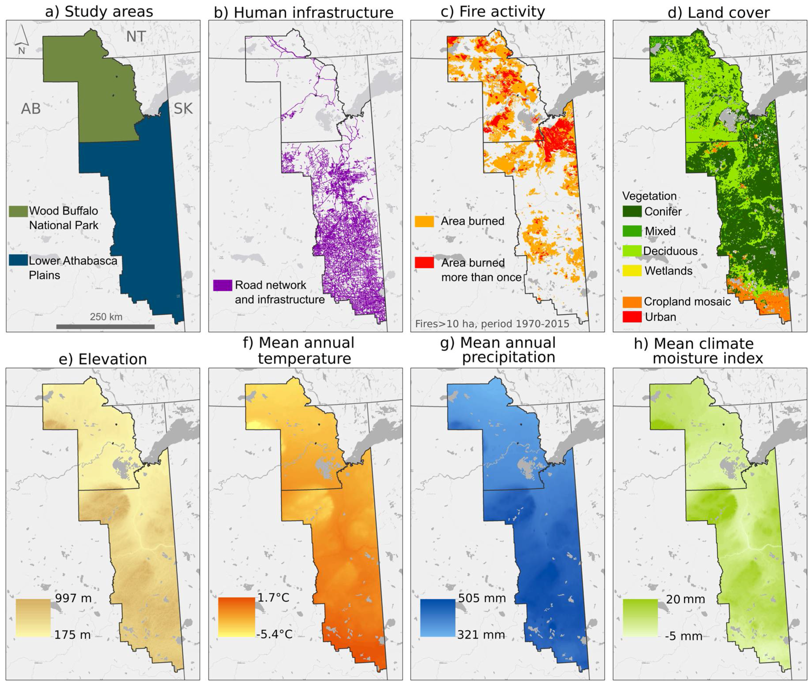
2.1. Study Areas
2.2. Fire Variables
2.3. Fire-Climate Variables
2.4. Statistical Analysis
2.4.1. Linear Trend Detection
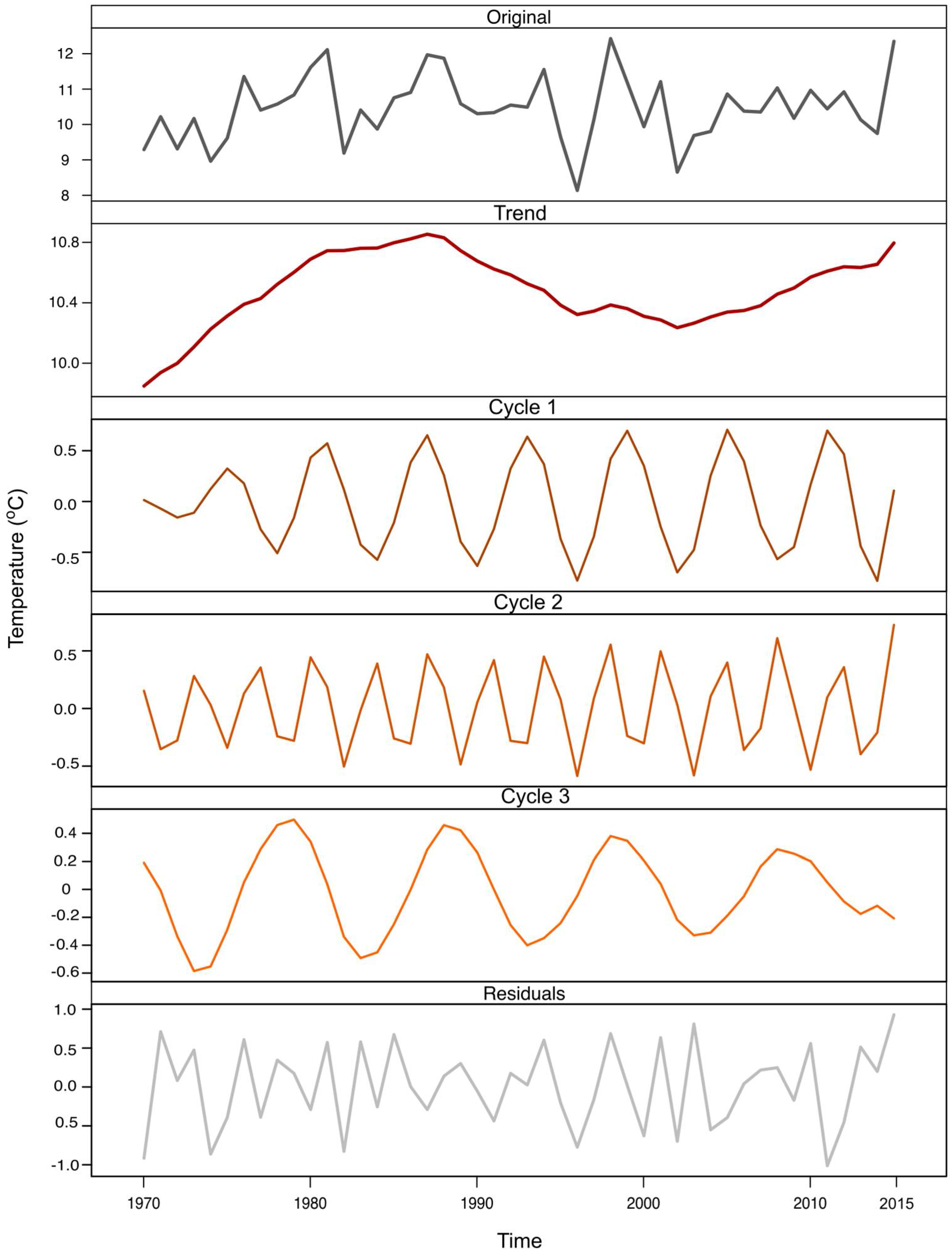
2.4.2. Time Series Decomposition
2.4.3. Cross-Correlations of Time Series
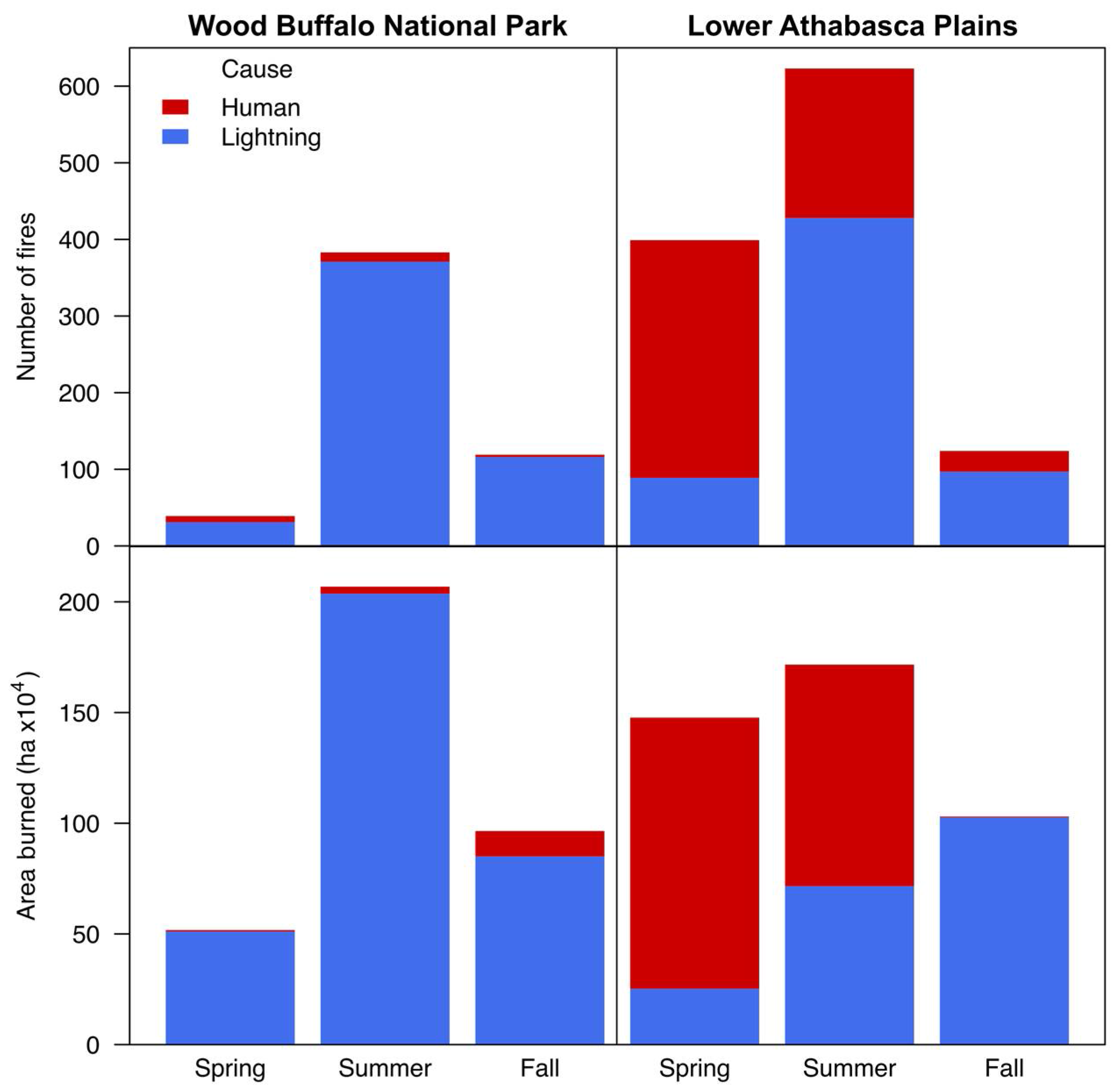
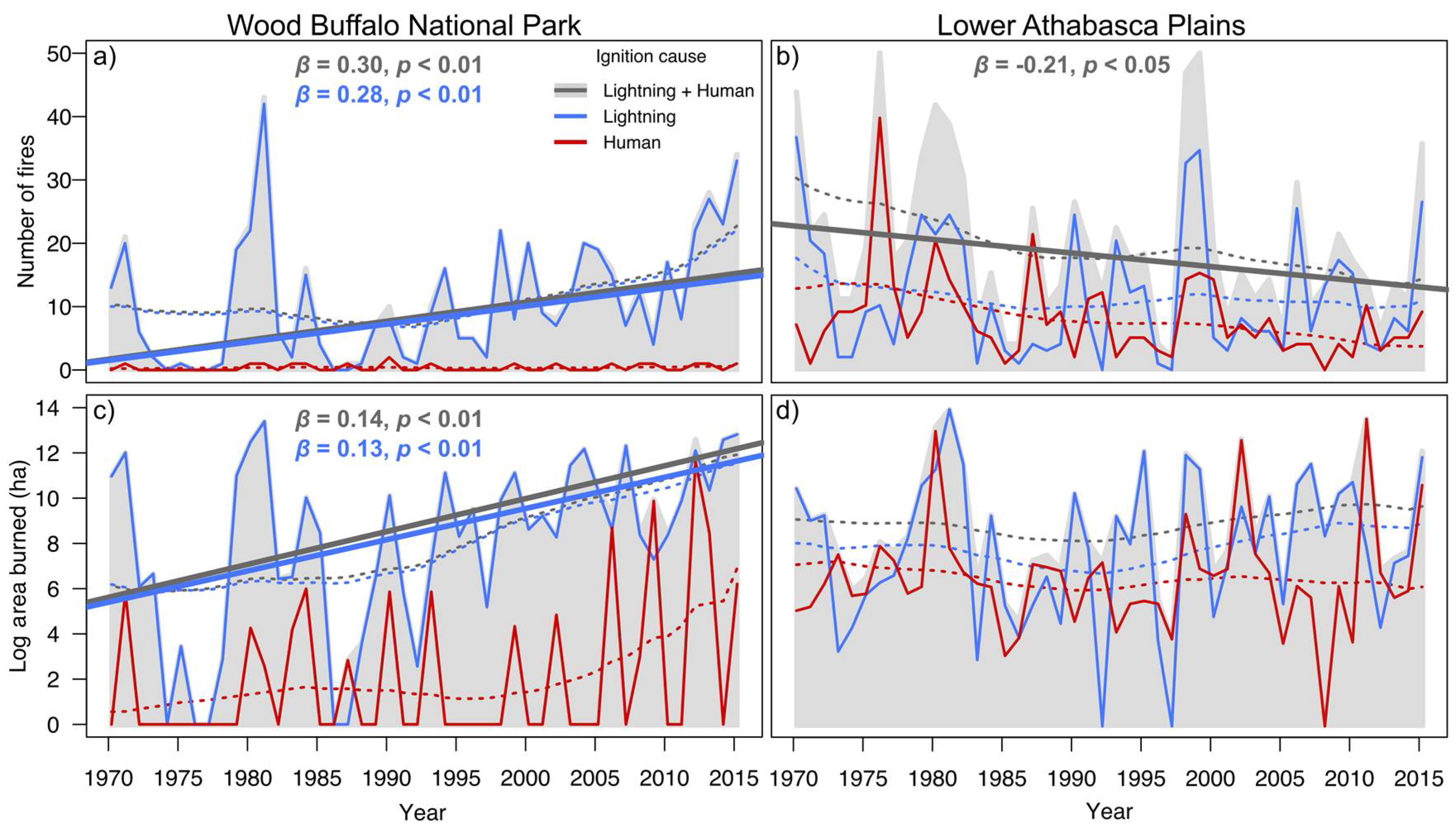
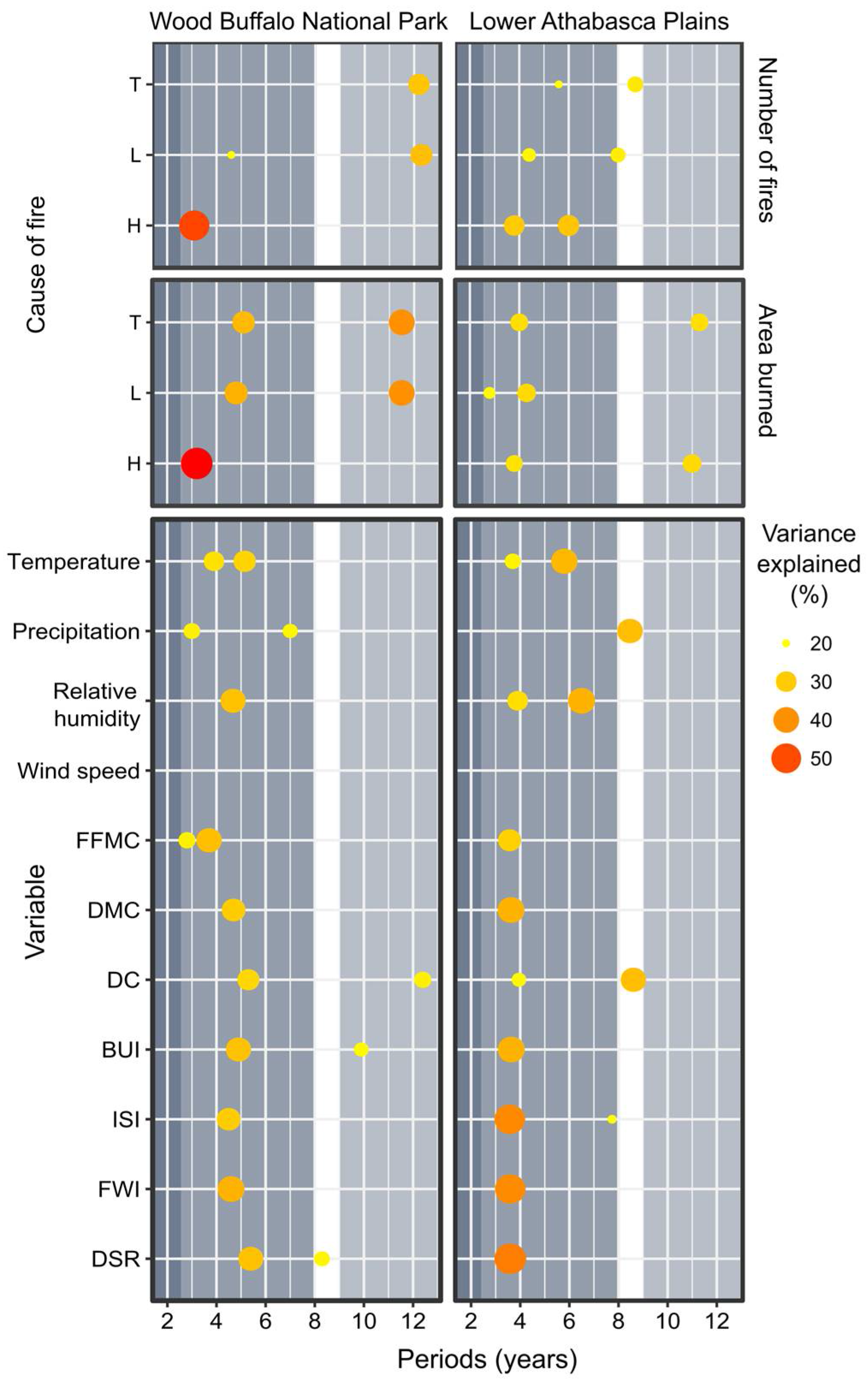
3. Results
4. Discussion
5. Conclusions
Acknowledgments
Author Contributions
Conflicts of Interest
Appendix A


| Region | WBNP | LAP | ||||
|---|---|---|---|---|---|---|
| Cause | L + H | L | H | L + H | L | H |
| Number of fires | 541 (100%) | 518 (95.75%) | 23 (4.25%) | 1146 (100%) | 614 (53.60%) | 532 (46.40%) |
| Proportional number of fires (fires per 100 kha) | 12.70 | 12.14 | 0.54 | 14.44 | 7.74 | 6.70 |
| Area burned (ha × 104) | 355.08 (100%) | 339.87 (95.70%) | 15.21 (4.30%) | 422.39 * (100%) | 199.56 (47.25%) | 222.83 (52.75%) |
| Mean fire size (ha) | 7332.51 | 6978.90 | 353.60 | 7384.40 | 4411.42 | 2972.98 |

References
- Weber, M.G.; Stocks, B.J. Forest Fires and Sustainability in the Boreal Forest of Canada. Ambio 1998, 27, 545–550. [Google Scholar]
- Stocks, B.J.; Mason, J.A.; Todd, J.B.; Bosch, E.M.; Wotton, B.M.; Amiro, B.D.; Flannigan, M.D.; Hirsch, K.G.; Logan, K.A.; Martell, D.L.; et al. Large forest fires in Canada, 1959–1997. J. Geophys. Res. 2002, 108. [Google Scholar] [CrossRef]
- Bergeron, Y.; Leduc, A.; Harvey, B.; Gauthier, S. Natural fire regime: A guide for sustainable management of the Canadian boreal forest. Silva Fenn. 2002, 36, 81–95. [Google Scholar] [CrossRef]
- Johnstone, J.F. Response of boreal plant communities to variations in previous fire-free interval. Int. J. Wildl. Fire 2006, 15, 497–508. [Google Scholar] [CrossRef]
- Kurz, W.; Apps, M. A 70-year retrospective analysis of carbon fluxes in the Canadian forest sector. Ecol. Appl. 1999, 9, 526–547. [Google Scholar] [CrossRef]
- Amiro, B.D.; Stocks, B.J.; Alexander, M.E.; Flannigan, M.D.; Wotton, B.M. Fire, climate change, carbon and fuel management in the Canadian boreal forest. J. Wildl. Fire 2001, 10, 405–413. [Google Scholar] [CrossRef]
- Martell, D.L. The impact of fire on timber supply in Ontario. For. Chron. 1994, 70, 164–173. [Google Scholar] [CrossRef]
- Bowman, D.M.J.S.; Balch, J.; Artaxo, P.; Bond, W.J.; Cochrane, M.A.; D’Antonio, C.M.; Defries, R.; Johnston, F.H.; Keeley, J.E.; Krawchuk, M.A.; et al. The human dimension of fire regimes on Earth. J. Biogeogr. 2011, 38, 2223–2236. [Google Scholar] [CrossRef] [PubMed]
- Hope, E.S.; McKenney, D.W.; Pedlar, J.H.; Stocks, B.J.; Gauthier, S. Wildfire Suppression Costs for Canada under a Changing Climate. PLoS ONE 2016, 11, 2223–2236. [Google Scholar] [CrossRef] [PubMed]
- Weber, M.G.; Flannigan, M.D. Canadian boreal forest ecosystem structure and function in a changing climate: Impact on fire regimes. Environ. Rev. 1997, 5, 145–166. [Google Scholar] [CrossRef]
- Flannigan, M.; Wotton, B. Climate, weather, and area burned. In Forest Fires: Behavior and Ecological Effects; Johnson, E.A., Miyanishi, K., Eds.; Academic Press: New York, NY, USA, 2001; pp. 351–373. [Google Scholar]
- Cumming, S.G. A parametric model of the fire-size distribution. Can. J. For. Res. 2001, 31, 1297–1303. [Google Scholar] [CrossRef]
- Krawchuk, M.A.; Cumming, S.G. Effects of biotic feedback and harvest management on boreal forest fire activity under climate change. Ecol. Appl. 2011, 21, 122–136. [Google Scholar] [CrossRef] [PubMed]
- Podur, J. Spatial and temporal patterns of forest fire activity in Canada. Ph.D. Thesis, University of Toronto, Toronto, ON, Canada, 2001. [Google Scholar]
- Gralewicz, N.J.; Nelson, T.A.; Wulder, M.A. Factors influencing national scale wildfire susceptibility in Canada. For. Ecol. Manag. 2012, 265, 20–29. [Google Scholar] [CrossRef]
- Marlon, J.R.; Bartlein, P.J.; Carcaillet, C.; Gavin, D.G.; Harrison, S.P.; Higuera, P.E.; Joos, F.; Power, M.J.; Prentice, I.C. Climate and human influences on global biomass burning over the past two millennia. Nat. Geosci. 2008, 1, 697–702. [Google Scholar] [CrossRef]
- Gustafson, E.J.; Zollner, P.A.; Sturtevant, B.R.; He, H.S.; Mladenoff, D.J. Influence of forest management alternatives and land type on susceptibility to fire in northern Wisconsin, USA. Landsc. Ecol. 2004, 19, 327–341. [Google Scholar] [CrossRef]
- Parisien, M.; Peters, V.; Wang, Y. Spatial patterns of forest fires in Canada, 1980–1999. J. Wildl. Fire 2006, 15, 361–374. [Google Scholar] [CrossRef]
- Pechony, O.; Shindell, D.T. Driving forces of global wildfires over the past millennium and the forthcoming century. Proc. Natl. Acad. Sci. USA 2010, 107, 19167–19170. [Google Scholar] [CrossRef] [PubMed]
- Flannigan, M.; Cantin, A.S.; de Groot, W.J.; Wotton, M.; Newbery, A.; Gowman, L.M. Global wildland fire season severity in the 21st century. For. Ecol. Manag. 2013, 294, 54–61. [Google Scholar] [CrossRef]
- Ruffault, J.; Mouillot, F. How a new fire-suppression policy can abruptly reshape the fire-weather relationship. Ecosphere 2015, 6, art199. [Google Scholar] [CrossRef]
- Brotons, L.; Aquilué, N.; de Cáceres, M.; Fortin, M.-J.; Fall, A. How fire history, fire suppression practices and climate change affect wildfire regimes in Mediterranean landscapes. PLoS ONE 2013, 8, e62392. [Google Scholar] [CrossRef] [PubMed]
- Higuera, P.E.; Abatzoglou, J.T.; Littell, J.S.; Morgan, P. The changing strength and nature of fire-climate relationships in the northern Rocky Mountains, USA., 1902–2008. PLoS ONE 2015, 10, e0127563. [Google Scholar] [CrossRef] [PubMed]
- Cumming, S.G. Effective fire suppression in boreal forests. Can. J. For. Res. 2005, 786, 772–786. [Google Scholar] [CrossRef]
- Martell, D.L.; Sun, H. The impact of fire suppression, vegetation, and weather on the area burned by lightning-caused forest fires in Ontario. Can. J. For. Res. 2008, 38, 1547–1563. [Google Scholar] [CrossRef]
- Magnussen, S.; Taylor, S.W. Inter- and intra-annual profiles of fire regimes in the managed forests of Canada and implications for resource sharing. Int. J. Wildl. Fire 2012, 21, 328–341. [Google Scholar] [CrossRef]
- Murphy, P. Methods for evaluating the effects of forest fire management in Alberta. Ph.D. Thesis, University of British Columbia, Vancouver, BC, Canada, 1985. [Google Scholar]
- Alberta Agriculture and Forestry Forest Areas of Alberta. Available online: http://wildfire.alberta.ca/resources/maps-data/documents/ForestAreasAlberta-May03-2017.pdf (accessed on 4 November 2016).
- Alberta Environment and Parks Alberta Wildfire 2015 Statistics. Available online: http://aep.alberta.ca/files/PREV_AlbertaWildfire_2015_Infographic_.pdf (accessed on 1 January 2016).
- Alam, R.; Islam, S.; Mosely, E.; Thomas, S.; Dodwell, V.; Doel, D. Rapid Impact Assessment of Fort McMurray Wildfire. Available online: https://www.iclr.org/images/AlamIslam_QuickResponseSummary-ICLR.pdf (accessed on 7 January 2017).
- KPMG May 2016 Wood Buffalo Wildfire, Post-Incident Assessment Report. Available online: https://www.alberta.ca/assets/documents/Wildfire-KPMG-Report.pdf (accessed 7 January 2017).
- Parks Canada Agency Fire Management Zones. Available online: https://www.pc.gc.ca/en/nature/science/conservation/feu-fire/feuveg-fireveg/incendies-wildfire (accessed on 1 January 2017).
- Natural Regions Committee. Natural Regions and Subregions of Alberta; Downing, D.J., Pettapiece, W.W., Eds.; Government of Alberta: Edmonton, AB, Canada, 2006; Pub. No. T/852.
- Alberta Biodiversity Monitoring Institute ABMI Wall-to-wall Land Cover Map. 2012. Available online: http://abmi.ca/home/data-analytics/da-top/da-product-overview/GIS-Land-Surface/Land-Cover.html (accessed on 10 April 2017).
- US Geological Survey USGS. Global Visualization Viewer. Available online: http://glovis.usgs.gov (accessed on 1 April 2017).
- Wang, T.; Hamann, A.; Spittlehouse, D.L.; Murdock, T.Q. ClimateWNA—High-resolution spatial climate data for western North America. J. Appl. Meteorol. Climatol. 2012, 51, 16–29. [Google Scholar] [CrossRef]
- Canadian Forest Service. Canadian National Fire Database—Agency Fire Data. 2016. Available online: http://cwfis.cfs.nrcan.gc.ca/datamart (accessed on 15 November 2016).
- Government of Alberta. Forest and Prairie Protection Act. Available online: http://www.qp.alberta.ca/574.cfm?page=F19.cfm&leg_type=Acts&isbncln=9780779726554%5CnR:%5CAdmin%5COffice%5CRefMan%5CPrairieOffices%5CCalgaryOffice%5C1322-EnvironmentalAssessment%5C1332-Biophysical%5CReferences (accessed on 20 July 2016).
- Armstrong, G.W. A stochastic characterisation of the natural disturbance regime of the boreal mixedwood forest with implications for sustainable forest management. Can. J. For. Res. 1999, 29, 424–433. [Google Scholar] [CrossRef]
- Van Wagner, C.E. Development and Structure of the Canadian Forest Fire Weather Index System; Forestry Technical Report 35; Canadian Forestry Service: Otawa, ON, Canada, 1987. [Google Scholar]
- Natural Resources Canada. Canadian Forest Fire Weather Index System from the Canadian Wildland Fire Information System; Version 3.0; Canadian Forest Service, Northern Forestry Center: Edmonton, AB, Canada, 2016. [Google Scholar]
- R Development Core Team. R: A Language and Environment for Statistical Computing; R Foundation for Statistical Computing: Vienna, Austria. Available online: https://www.R-project.org/ (accessed on 4 June 2016).
- Hyndman, R.J.; Khandakar, Y. Automatic time series forecasting: The forecast package for R. J. Stat. Softw. 2008, 27, C3. [Google Scholar] [CrossRef]
- Metcalfe, A.V.; Cowpertwait, P.S.P. Introductory Time Series with R; Springer New York: New York, NY, USA, 2009; ISBN 978-0-387-88697-8. [Google Scholar]
- Crawley, M.J. The R Book, 2nd ed.; John Wiley and Sons: Chichester, UK, 2013; ISBN 9780470973929. [Google Scholar]
- Fox, J.; Weisberg, S. An {R} Companion to Applied Regression; Sage Publications: Thousand Oaks, CA, USA, 2002; ISBN 9781412975148. [Google Scholar]
- Harrell, F.E. Regression Modeling Strategies, 2nd ed.; Springer International Publishing: Cham, Switzerland, 2015; ISBN 978-3-319-19424-0. [Google Scholar]
- Jain, P. Package “MKcorrR”: Mann-Kendall Test with Autocorrelated Data. Unpublished work. 2017. [Google Scholar]
- Golyandina, N.; Korobeynikov, A. Basic singular spectrum analysis and forecasting with R. Comput. Stat. Data Anal. 2014, 71, 934–954. [Google Scholar] [CrossRef]
- Golyandina, N.; Korobeynikov, A.; Shlemov, A.; Usevich, K. Multivariate and 2D extensions of singular spectrum analysis with the Rssa package. J. Stat. Softw. 2014, 67, 1–78. [Google Scholar] [CrossRef]
- Yue, S.; Wang, C.Y. Assessment of the significance of sample serial correlation by the bootstrap test. Water Resour. Manag. 2002, 16, 23–35. [Google Scholar] [CrossRef]
- Roy, R.; Kailath, T. ESPRIT-estimation of signal parameters via rotational invariance techniques. IEEE Trans. Acoust. 1989, 37, 984–995. [Google Scholar] [CrossRef]
- Stoffer, D. Astsa: Applied Statistical Time Series Analysis. 2016. Available online: https://CRAN.R-project.org/package=astsa (accessed on 20 January 2017).
- Ebisuzaki, W.; Ebisuzaki, W. A method to estimate the statistical significance of a correlation when the data are serially correlated. J. Clim. 1997, 10, 2147–2153. [Google Scholar] [CrossRef]
- Baddouh, M.; Meyers, S.R.; Carroll, A.R.; Beard, B.L.; Johnson, C.M. Lacustrine 87Sr/86Sr as a tracer to reconstruct Milankovitch forcing of the Eocene hydrologic cycle. Earth Planet. Sci. Lett. 2016, 448, 62–68. [Google Scholar] [CrossRef]
- Meyers, S.R. astrochron: An R Package for Astrochronology. 2014. Available online: https://cran.r-project.org/package=astrochron (accessed on 15 December 2016).
- Tymstra, C.; Flannigan, M.D.; Armitage, O.B.; Logan, K. Impact of climate change on area burned in Alberta’s boreal forest. Int. J. Wildl. Fire 2007, 16, 153–160. [Google Scholar] [CrossRef]
- Girardin, M.P. Interannual to decadal changes in area burned in Canada from 1781 to 1982 and the relationship to Northern Hemisphere land temperatures. Glob. Ecol. Biogeogr. 2007, 16, 557–566. [Google Scholar] [CrossRef]
- Jolly, W.M.; Cochrane, M.A.; Freeborn, P.H.; Holden, Z.A.; Brown, T.J.; Williamson, G.J.; Bowman, D.M.J.S. Climate-induced variations in global wildfire danger from 1979 to 2013. Nat. Commun. 2015, 6, 7537. [Google Scholar] [CrossRef] [PubMed]
- Parisien, M.-A.; Miller, C.; Parks, S.A.; DeLancey, E.R.; Robinne, F.-N.; Flannigan, M.D. The spatially varying influence of humans on area burned in North America. Environ. Res. Lett. 2016, 11, 075005. [Google Scholar] [CrossRef]
- Robinne, F.-N.; Parisien, M.-A.; Flannigan, M.D. Anthropogenic influence on wildfire activity in Alberta, Canada. Int. J. Wildl. Fire 2016, 25, 1131–1143. [Google Scholar] [CrossRef]
- Gralewicz, N.J.; Nelson, T.A.; Wulder, M.A. Spatial and temporal patterns of wildfire ignitions in Canada from 1980 to 2006. Int. J. Wildl. Fire 2012, 21, 230. [Google Scholar] [CrossRef]
- Podur, J.; Martell, D.; Knight, K. Statistical quality control analysis of forest fire activity in Canada. Can. J. For. 2002, 205, 195–205. [Google Scholar] [CrossRef]
- Ryu, S.-R.; Chen, J.; Zheng, D.; Bresee, M.K.; Crow, T.R. Simulating the effects of prescribed burning on fuel loading and timber production (EcoFL) in managed northern Wisconsin forests. Ecol. Modell. 2006, 196, 395–406. [Google Scholar] [CrossRef]
- Krawchuk, M.A.; Cumming, S.G.; Flannigan, M.D.; Wein, R.W. Biotic and abiotic regulation of lightning fire initiation in the mixedwood boreal forest. Ecology 2006, 87, 458–468. [Google Scholar] [CrossRef] [PubMed]
- Cumming, S. Forest type and wildfire in the Alberta boreal mixedwood: What do fires burn? Ecol. Appl. 2001, 11, 97–110. [Google Scholar] [CrossRef]
- Parisien, M.-A.; Parks, S.A.; Krawchuk, M.A.; Flannigan, M.D.; Bowman, L.M.; Moritz, M.A. Scale-dependent controls on the area burned in the boreal forest of Canada, 1980-2005. Ecol. Appl. 2011, 21, 789–805. [Google Scholar] [CrossRef] [PubMed]
- Fréjaville, T.; Curt, T. Seasonal changes in the human alteration of fire regimes beyond the climate forcing. Environ. Res. Lett. 2017, 12, 35006. [Google Scholar] [CrossRef]
- Archibald, S.; Roy, D.P.; van Wilgen, B.W.; Scholes, R.J. What limits fire? An examination of drivers of burnt area in Southern Africa. Glob. Chang. Biol. 2009, 15, 613–630. [Google Scholar] [CrossRef]
- Wang, Y.; Anderson, K. An evaluation of spatial and temporal patterns of lightning-and human-caused forest fires in Alberta, Canada, 1980–2007. Int. J. Wildl. Fire 2011, 19, 1059–1072. [Google Scholar] [CrossRef]
- Veraverbeke, S.; Rogers, B.M.; Goulden, M.L.; Jandt, R.R.; Miller, C.E.; Wiggins, E.B.; Randerson, J.T. Lightning as a major driver of recent large fire years in North American boreal forests. Nat. Clim. Chang. 2017, 7, 529–534. [Google Scholar] [CrossRef]
- Erni, S.; Arseneault, D.; Parisien, M.A.; Bégin, Y. Spatial and temporal dimensions of fire activity in the fire-prone eastern Canadian taiga. Glob. Chang. Biol. 2017, 23, 1152–1166. [Google Scholar] [CrossRef] [PubMed]
- Arienti, M.C.; Cumming, S.G.; Krawchuk, M.A.; Boutin, S. Road network density correlated with increased lightning fire incidence in the Canadian western boreal forest. Int. J. Wildl. Fire 2009, 18, 970–982. [Google Scholar] [CrossRef]
- Balch, J.K.; Bradley, B.A.; Abatzoglou, J.T.; Nagy, R.C.; Fusco, E.J. Human-started wildfires expand the fire niche across the United States. Proc. Natl. Acad. Sci. USA 2017, 114. [Google Scholar] [CrossRef] [PubMed]
- Albert-Green, A.; Dean, C.B.; Martell, D.L.; Woolford, D.G. A methodology for investigating trends in changes in the timing of the fire season with applications to lightning-caused forest fires in Alberta and Ontario, Canada. Can. J. For. Res. 2013, 43, 39–45. [Google Scholar] [CrossRef]
- Wang, X.; Thompson, D.K.; Marshall, G.A.; Tymstra, C.; Carr, R.; Flannigan, M.D. Increasing frequency of extreme fire weather in Canada with climate change. Clim. Chang. 2015, 130, 573–586. [Google Scholar] [CrossRef]
- Fauria, M.M.; Johnson, E.A. Large-scale climatic patterns control large lightning fire occurrence in Canada and Alaska forest regions. J. Geophys. Res. Biogeosci. 2006, 111, G04008. [Google Scholar] [CrossRef]
- Mori, A.S. Climatic variability regulates the occurrence and extent of large fires in the subalpine forests of the Canadian Rockies. Ecosphere 2011, 2, 1–20. [Google Scholar] [CrossRef]
- Bridgman, H.A.; Oliver, J.; Glantz, M. The Global Climate System: Patterns, Processes, and Teleconnections; Cambridge University Press: Cambridge, UK, 2006; ISBN 052182642X. [Google Scholar]
- Schoennagel, T.; Veblen, T.T.; Kulakowski, D.; Holz, A. Multidecadal climate variability and climate interactions affect subalpine fire occurrence, Western Colorado (USA). Ecology 2007, 88, 2891–2902. [Google Scholar] [CrossRef] [PubMed]
- Schoennagel, T.; Veblen, T.T.; Romme, W.H.; Sibold, J.S.; Cook, E.R. ENSO and PDO variability affect drought-induced fire occurrence in rocky mountain subalpine forests. Ecol. Appl. 2005, 15, 2000–2014. [Google Scholar] [CrossRef]
- Pickell, P.D.; Coops, N.C.; Ferster, C.J.; Bater, C.W.; Blouin, K.D.; Flannigan, M.D.; Zhang, J. An early warning system to forecast the close of the spring burning window from satellite-observed greenness. Sci. Rep. 2017, 1, 14190. [Google Scholar] [CrossRef] [PubMed]


| Region | WBNP Area kha (%) | LAP Area kha (%) | ||
|---|---|---|---|---|
| Total | 4266 | (100) | 7932 | (100) |
| Cultivation | 0 | 134.80 | (3.16) | |
| Harvested (cut blocks) | 0 | 111.33 | (2.61) | |
| Mining | 0 | 32.42 | (0.76) | |
| Seismic lines | 0 | 29.86 | (0.70) | |
| Industrial-rural | 0 | 23.90 | (0.56) | |
| Roads and vegetated margins | 0.85 | (0.02) | 15.36 | (0.36) |
| Urban | 0 | 2.58 | (0.06) | |
| Total human-modified area | 0.85 | (0.02) | 350.25 | (8.21) |
| Acronym | Name | Units | Description |
|---|---|---|---|
| TEMP | Temperature | ℃ | A measure of heat present in the air |
| PRECIP | Precipitation | mm | A form of water, such as rain, snow etc. that condenses from the atmosphere and fall to the Earth |
| RH | Relative Humidity | % | Amount of water vapor present in air |
| WINS | Wind Speed | km/h | Velocity of air flow |
| FFMC | Fine Fuel Moisture Code | unitless | Moisture contained in the upper soil layer (litter and fine fuels) |
| DMC | Duff Moisture Code | unitless | Moisture for the loose organic layers of the soil, including medium-sized woody debris |
| DC | Drought Code | unitless | Moisture in deep compacted organic layer and large woody debris |
| ISI | Initial Spread Index | unitless | The expected rate of spread based on FFMC and wind speed |
| BUI | Buildup Index | unitless | Proxy for the fuel load available for combustion. Based on DMC and DC |
| FWI | Fire Weather Index | unitless | Reflects fire intensity and fire danger in forested areas. Based on ISI and BUI |
| DSR | Daily Severity Rating | unitless | Exponential transformation of FWI indicating severe conditions when DSR >2 |
| Acronym | Name | WBNP | LAP |
|---|---|---|---|
| TEMP | Temperature | 0.03 ** | 0.01 |
| PRECIP | Precipitation | <−0.01 * | −0.01 ** |
| RH | Relative Humidity | −0.15 ** | −0.06 ** |
| WINS | Wind Speed | −0.10 ** | −0.03 * |
| FFMC | Fine Fuel Moisture Code | 0.07 * | 0.07 ** |
| DMC | Duff Moisture Code | 0.30 ** | 0.23 ** |
| DC | Drought Code | 2.83 ** | 3.23 ** |
| ISI | Initial Spread Index | 0 | 0 |
| BUI | Buildup Index | 0.44 ** | 0.42 ** |
| FWI | Fire Weather Index | 0.04 | 0.06 ** |
| DSR | Daily Severity Rating | 0.02 | 0.02 * |
| Region | WBNP | LAP | |||||
|---|---|---|---|---|---|---|---|
| Cause | L + H | L | H | L + H | L | H | |
| WBNP | L + H | 1 | 0.96 ** | 0.17 * | 0.31 ** | 0.36 ** | 0.08 |
| L | 0.94 ** | 1 | 0.13 | 0.30 ** | 0.35 ** | 0.09 | |
| H | 0.09 | 0.04 | 1 | 0.18 | 0.24 * | −0.07 | |
| LAP | L + H | 0.26 * | 0.25 * | 0.10 | 1 | 0.68 ** | 0.37 ** |
| L | 0.33 ** | 0.32 ** | 0.09 | 0.76 ** | 1 | 0.06 | |
| H | −0.01 | −0.01 | 0 | 0.29 * | 0.09 | 1 |
| Number of Fires | Area Burned | |||||||||||
|---|---|---|---|---|---|---|---|---|---|---|---|---|
| Region | WBNP | LAP | WBNP | LAP | ||||||||
| Ignition cause | L + H | L | H | L + H | L | H | L + H | L | H | L + H | L | H |
| Temperature | 0.20 * | 0.19 * | 0.17 | 0.20 | 0.12 | 0.23 * | 0.07 | 0.07 | 0.1 | 0.10 | 0.09 | 0.17 * |
| Precipitation | −0.29 * | −0.27 * | −0.02 | −0.22 * | −0.21 * | −0.14 | −0.23 * | −0.25 * | 0.07 | −0.20 * | −0.21 * | −0.14 |
| Relative humidity | −0.24 * | −0.23 * | −0.05 | −0.20 | −0.13 | −0.18 * | −0.21 | −0.22 * | −0.03 | −0.27 * | −0.24 * | -0.22 * |
| Wind speed | −0.14 | −0.15 | −0.05 | −0.18 | −0.07 | −0.2 * | −0.27 | −0.23 | −0.09 | −0.02 | −0.01 | −0.12 |
| FFMC | 0.26 * | 0.24 * | 0.1 | 0.23 * | 0.22 * | 0.15 | 0.20 | 0.20 * | 0.05 | 0.29 * | 0.27 * | 0.19 * |
| DMC | 0.33 * | 0.32 ** | −0.01 | 0.27 * | 0.03 * | 0.21 * | 0.37 ** | 0.40 ** | −0.06 | 0.40 ** | 0.34 ** | 0.30 ** |
| DC | 0.34 | 0.34 ** | 0.04 | 0.23 * | 0.25 * | 0.18 * | 0.36 * | 0.40 ** | −0.02 | 0.24 * | 0.26 ** | 0.27 * |
| BUI | 0.20 * | 0.35 ** | 0 | 0.30 * | 0.26 * | 0.2 * | 0.37 ** | 0.40 ** | −0.03 | 0.40 ** | 0.35 ** | 0.30 * |
| ISI | 0.21 * | 0.20 * | 0.10 | 0.28 * | 0.30 * | 0.1 | 0.23 * | 0.26 * | 0.07 | 0.40 ** | 0.32 ** | 0.21 * |
| FWI | 0.30 * | 0.30 * | 0.06 | 0.31 * | 0.30 * | 0.16 | 0.36 ** | 0.40 ** | 0.01 | 0.44 ** | 0.36 ** | 0.30 ** |
| DSR | 0.28 * | 0.26 * | 0.01 | 0.34 ** | 0.30 ** | 0.20 | 0.37 ** | 0.40 ** | 0.02 | 0.44 ** | 0.35 ** | 0.31 ** |
© 2018 by the authors. Licensee MDPI, Basel, Switzerland. This article is an open access article distributed under the terms and conditions of the Creative Commons Attribution (CC BY) license (http://creativecommons.org/licenses/by/4.0/).
Share and Cite
Campos-Ruiz, R.; Parisien, M.-A.; Flannigan, M.D. Temporal Patterns of Wildfire Activity in Areas of Contrasting Human Influence in the Canadian Boreal Forest. Forests 2018, 9, 159. https://doi.org/10.3390/f9040159
Campos-Ruiz R, Parisien M-A, Flannigan MD. Temporal Patterns of Wildfire Activity in Areas of Contrasting Human Influence in the Canadian Boreal Forest. Forests. 2018; 9(4):159. https://doi.org/10.3390/f9040159
Chicago/Turabian StyleCampos-Ruiz, Rodrigo, Marc-André Parisien, and Mike D. Flannigan. 2018. "Temporal Patterns of Wildfire Activity in Areas of Contrasting Human Influence in the Canadian Boreal Forest" Forests 9, no. 4: 159. https://doi.org/10.3390/f9040159
APA StyleCampos-Ruiz, R., Parisien, M.-A., & Flannigan, M. D. (2018). Temporal Patterns of Wildfire Activity in Areas of Contrasting Human Influence in the Canadian Boreal Forest. Forests, 9(4), 159. https://doi.org/10.3390/f9040159