Article

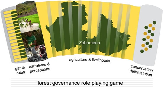
Approaching Local Perceptions of Forest Governance and Livelihood Challenges with Companion Modeling from a Case Study around Zahamena National Park, Madagascar

by
Nathalie Bodonirina
1,
Lena M. Reibelt
2,
Natasha Stoudmann
3,
Juliette Chamagne
3,
Trevor G. Jones
4,
Annick Ravaka
1,
Hoby V. F. Ranjaharivelo
1,
Tantelinirina Ravonimanantsoa
1,
Gabrielle Moser
3,
Arnaud De Grave
5,
Claude Garcia
3,6,
Bruno S. Ramamonjisoa
1,
Lucienne Wilmé
7,8 and
Patrick O. Waeber
3,*
1
ESSA Forêts, Ankatso, BP 175, Antananarivo 101, Madagascar
2
Madagascar Wildlife Conservation, Lot 17420 bis, Avaradrova Sud, Ambatondrazaka 503, Madagascar
3
Forest Managament and Development Group, Ecosystems Management, ETH Zurich, Universitätsstrasse 16, 8098 Zurich, Switzerland
4
Department of Forest Resources Management, Forest Sciences Centre, 2045–2424 Main Mall, University of British Columbia, Vancouver, BC V6T 1Z4, Canada
5
Association Bricolages Ondulatoires & Particulaires, 37 lot. Champ du Bourg, 38570 Goncelin, France
6
UR Forêts et Société (F&S), Département Environnement et Sociétés du CIRAD, Campus International de Baillarguet, 34398 Montpellier CEDEX 5, France
7
Missouri Botanical Garden, Madagascar Research & Conservation Program, BP 3391, Antananarivo 101, Madagascar
8
World Resources Institute, Madagascar Program, BP 3884, Antananarivo 101, Madagascar
*
Author to whom correspondence should be addressed.
Forests 2018, 9(10), 624; https://doi.org/10.3390/f9100624
Submission received: 24 August 2018 / Revised: 27 September 2018 / Accepted: 3 October 2018 / Published: 10 October 2018
(This article belongs to the Special Issue Participatory Forestry: Involvement, Information and Science)

Abstract

:
Community-based natural resource management (CBNRM) is a widely used approach aimed at involving those utilizing resources in their management. In Madagascar, where forest decentralization has been implemented since the 1990s to spur local resource users’ involvement in management processes, impacts remain unclear. This study aimed to investigate farmers’ perceptions and practices regarding forest use under various forest governance systems, using a participatory gaming approach implemented in the Zahamena region of Madagascar. We report on (i) the conceptual models of the Zahamena socio-ecological system; (ii) the actual research tool in the form of a tabletop role-playing game; and (iii) main outcomes of the gaming workshops and accompanying research. The results allow the linking of game reality with real-world perceptions based on game debriefing discussions and game workshop follow-up surveys, as well as interviews and focus group research with other natural resource users from the study area. Results show that the Zahamena protected area plays the role of buffer zone by slowing down deforestation and degradation. However, this fragile barrier and CBNRM are not long-term solutions in the face of occurring changes. Rather, the solution lies in one of the main causes of the problem: agriculture. Further use of tools such as participatory gaming is recommended to enhance knowledge exchange and the development of common visions for the future of natural resource management to foster resilience of forest governance.

Graphical Abstract

1. Introduction

Agriculture is one of the main drivers of global deforestation, and shifting agriculture is responsible for 92% of tree cover loss in Africa [1]. Land conversion for agricultural production affects water, soil, air, forests, and many ecosystems [2]. It caused the clearing or conversion of 70% of grasslands, 50% of open woodlands, 45% of temperate dry forests, and 27% of tropical forests, with some five to ten million hectares of forest annually being lost to agriculture [3] or 39 million ha in Africa for the period of 2001–2015 [1]. Former studies showed that the combination of population growth and shifting cultivation is the main cause of deforestation in pantropical regions [4]. A recent study showed that tree cover increased globally between 1982 and 2016 due to a net loss of forest cover in the tropics and a net gain in the extra-tropics [1].
In Madagascar, less than 18% of terrestrial surface was covered by forests in early 2000 [5]. These ecosystems contain a high degree of biodiversity, being home to more than 12,000 endemic plant species [6] and over 700 endemic species of vertebrates [7,8]. The tree cover is continuously decreasing, with a steep increase since 2013 and a maximum in 2017 [9,10]. Deforestation at the national scale remains unchecked with some 100,000 hectares lost annually. Average deforestation rates have been on a progressive rise since 2005, where annual nationwide rates translated to around 1.5% [11]. In certain areas of Eastern Madagascar, the rates of humid dense forest loss surpassed four percent in 2017 [9]. Forest ecosystems and their biodiversity are, therefore, highly threatened due to ongoing deforestation and degradation despite concerted international conservation efforts over the past 30 years [12,13]. A mix of proximate and ultimate factors were identified linking forest loss to human activities, such as agricultural and pastoral expansion [8,14,15], cash-cropping [14,16], changing international commodity prices [16], increased access through new roads to formerly remote areas [17], or large-scale agri-business [14]. Farmers’ slash-and-burn practices (Malagasy tavy) heavily participate toward the depletion of forest biodiversity [18,19,20,21,22]. These practices are, however, necessary for the great majority of the population, as they often lack alternative options in securing their livelihoods [23,24,25].
The positive outcomes of community-based natural resource management (CBNRM) still need to be proven [26]. According to Mesham and Lumbasi [27], decentralization is a foreign idea in many countries, and had the opposite impact to the intended empowerment of communities, thus hampering partnerships at the cost of conservation. Pollini and Lassoie [28] put similar critiques forward in the case of Madagascar, where the World Bank, together with international backers and non-governmental organizations (NGOs) began pushing the Malagasy government to start establishing and implementing forest decentralization in the late 1990s in the hope of slowing deforestation and degradation rates while conserving biodiversity, in the form of VOIs (vondron’olona ifotony, an association of rural stakeholders that entered into management contract in the GELOSE process) [13,29,30]. The GELOSE (Gestion Locale Sécurisée, secure local management) policy, which regulates the transfer of property rights to local communities, is integrated into the national forestry policy (Law 97-107 and Decree 97-1200), and is applicable to forests, pastures, water, and wildlife. However, because implementing the GELOSE was deemed cumbersome (e.g., Reference [31]), the Contractual Forest Management (GCF, Gestion Contractualisée des Forêts) was issued as an enabling legislation with focus on forests (Order No. 2001-122). The GCF aimed to reduce the contract signatories from a tri-partite agreement to the State (Ministry of Environment, Water, and Forests), and to the community residents (VOI) [32,33,34]. However, its implementation was widely criticized due to its top-down nature. The interests of the actual community management associations (local communities) were being trumped by external environmental mediators (international NGOs) driving the process (e.g., References [28,35]), despite the fundamental necessity of CBNRM to be a partnership, in this case between local communities and the Forest Administration. The large-scale implementation of community-based natural resource management agreements—to date, some 450 agreements were signed across Madagascar [36]—still leaves many households with little incentive to protect their natural resources [22,37].
The current form of community-based natural resource management (CBNRM) in Madagascar is a type of co-management where responsibilities are shared among various stakeholders, all of whom are committed to ensuring that the local communities are actively involved in the management of the natural resources. The cantonnement forestier is part of the Forest Administration and is the institution responsible for the management of the forests under its jurisdiction. The forest administration formalizes the contracts of management transfer to the local communities, or VOIs. It supervises and advises the VOI and assists the judicial police role. Through the transfer of management, some forest management responsibilities are delegated to the local communities, including those pertaining to user rights of the forests. The VOIs set surveillance patrols, apply the dina (local rules) when possible, or report to the forestry administration otherwise. In the case of protected areas managed by the Madagascar National Parks (MNP), a management unit can invite members of a local community; they are grouped in a Comité Local du Parc or CLP to participate in the protection of natural resources by joining surveillance patrols or zoning tasks. The MNP can also initiate a transfer of an area of forests to local communities to strengthen the protection of a park, but final approval and the official contract linked to the transfer remain the responsibility of the Forest Administration (cf. [38] for more details on management structures in relation to protected area management). It remains unclear whether community-based natural resource management contributed to a slowing down of deforestation and degradation at the local scale [39,40].
There are claims of transdisciplinary and participatory approaches to natural resource management that overcome sectorial divides in the context of decentralized governance [41]. Many of these concepts, however, lack operability [42]. More experience is required to help practitioners implement such approaches, and particularly to understand how information and research can feed decision-making at individual, community, and political levels, and ultimately be incorporated into the policy process [43,44,45]. Potential barriers are lacking guidelines and technical expertise. How to go about breaching the science–policy–practice divide is still debated [11,46], and most are simply “muddling through” (cf. Reference [47]). One of the conditions that international donors imposed on the government of Madagascar is decentralization [12]; however, in fact, the decision-makers themselves lack guidelines on how to implement decentralized territorial governance spatially and temporally [13]. Since the devolution of forest governance in the 1990s in an act to give rural people more responsibilities over their resources (cf. Reference [48]), the number and interactions of stakeholders involved at various levels of forestry increased in complexity. Forest governance now has all the ingredients of a wicked problem (sensu Reference [49]), where a mélange of value and knowledge systems meet, i.e., where international, national, and local interests are competing over the same resources, over access (or lack thereof), user rights, and over decision power. Reasons for, or drivers of, deforestation are found in a complex interrelationship of socio-economic and political factors [4]. To better understand forest and other land use by rural resource users, we investigate here farmers’ practices and perceptions under different forest governance systems.
This research is part of the AlaReLa project (Alaotra Resilience Landscape, 2013–2017) based on a transdisciplinary approach where a multitude of research methods were applied to facilitate participation and involvement of local stakeholders and regional decision-makers in the Maningory watershed. In this paper, we focus on participatory gaming based on companion modeling (ComMod), a participatory modeling approach aimed to tackle natural resource management issues [50] around Zahamena National Park. Given the complex nature of this natural resource management (NRM) problem (forest governance regimes), and its interactions with various stakeholders, our research approach is exploratory in nature; through our gaming approach, we first try to understand the system under scrutiny (which is Objective 1 of ComMod, cf. [50] to see whether any patterns or surprises may emerge. Secondly, this spurs discussions revolving around these outcomes (governance/livelihoods). The engagement with various stakeholders (as done in this research), especially with groups that usually go unheard (e.g., subsistence farmers), combined with the sharing of results (ongoing), has the potential to better involve and inform the actual decision-makers and their policymaking at various levels (Objective 2 of ComMod, cf. [50]).
This contribution centers on a forest governance game developed in and for the Zahamena region, eastern Madagascar. Our overarching research objectives were to explore farmers’ perceptions of forest use and governance in the light of CBNRM and its impacts in the Zahamena region, which currently remain unclear. Our two working questions were as follows: (i) (In what way) does the management system impact farmers’ (gaming) decisions and behavior? (ii) (In what way) does the management system have an impact on (virtual and real-life) forest status/deforestation? In this publication, we report on the actual research tool, a role-playing game (RPG). The results focus on (i) the co-constructed conceptual models of the Zahamena socio-ecological system (interactions of actors and resources, land-type dynamics), which informed and guided the collaborative development of the RPG; (ii) main outcomes of the gaming workshops (virtual world), including game debriefing and discussions addressing game reality and decisions (with a focus on stakeholder perspectives on the governance challenges accounting for deforestation); (iii) land-cover mapping to gain insights into forest cover change in the past 25 years; (iv) real-world perceptions and narratives of resource users, linking the game experience with the real world. Further interviews, focus groups, and “ethnophotography in environmental science”—an approach using ethnography-inspired photography to explore landscape and land-use perceptions of local resource users [51]—were used in complement.

2. Materials and Methods
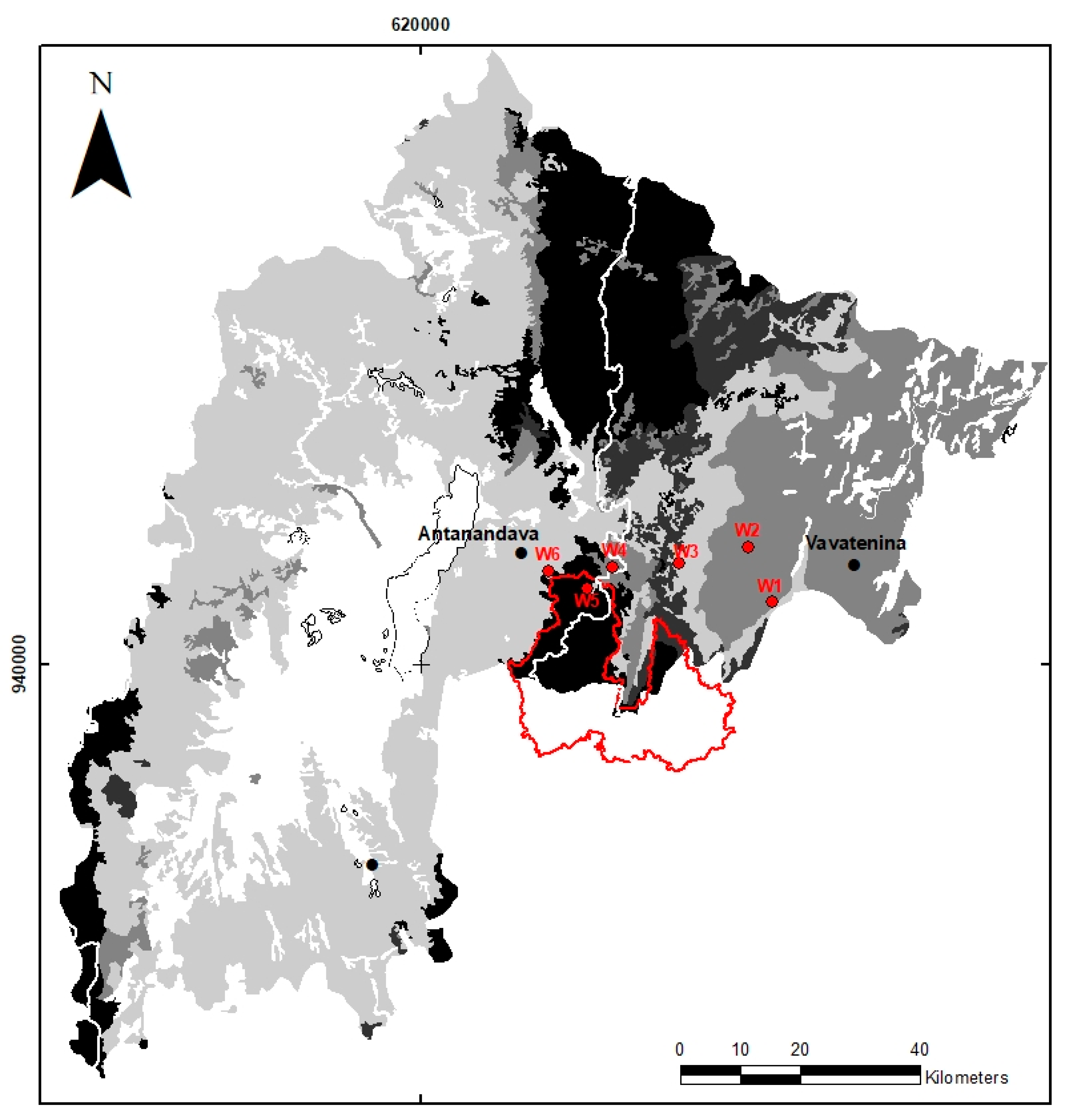
2.1. Study Area

Our research focuses on the Zahamena forest (Figure 1), which, in most parts, is under a protected area management regime. Zahamena is located in the east of the country, at the nexus of the Alaotra-Mangoro and Analanjirofo regions. The region of Lake Alaotra represents an agricultural hub as a center of rice production, and the Analanjirofo as its vernacular name implies (jirofo means clove) is an important region in cash crop production. Zahamena was the third Strict Nature Reserve of Madagascar established 31 December 1927. A central enclave was part of the reserve in 1927, and the continued presence of several villages over time led to the area of the enclave being degazetted in 1966. These villages kept growing and a further area was degazetted when Zahamena was partly turned into a National Park in 1997 (International Union for Conservation of Nature (IUCN) category II; the idea was to open the Strict Nature Reserve and turn it into a National Park, thus allowing visits not only from tourists but also—and especially—communities). In 2007, Zahamena was amongst six rainforest sites listed as a World Heritage Site, known as the Rainforests of Atsinanana. In 2015, the total Zahamena area became a National Park, and today, it covers a total area of 64,935 hectares under the management of Madagascar National Parks (MNP, formerly ANGAP). MNP agents ensure the ecological monitoring and conduct forest patrols. The local forest patrols (CLP, Comité Local du Parc, usually villagers from around Zahamena) support the MNP in forest monitoring. The VOI is responsible for the forest and dina (local rules) monitoring in the community-based forest areas. The association reports directly to the Forest Administration (chef de cantonnement or chef du cantonnement forestier as a subdivision of Forest Administration at the district level) and deals with usage requests from the community. There are currently 14 VOIs around Zahamena, six of which are in the commune of Antanandava. The two communes of Antanandava and Vavatenina mostly depend on agricultural production for both subsistence and markets, with a majority of villagers engaging in self-subsistence activities. Many do have more than just one activity, which is typical for the region (e.g., Reference [52]).
Zahamena National Park has a zoning plan; this plan de gestion is composed of the core zone for conservation (noyau dur) and the buffer zone (zone tampon with ZOC—zone à utilisation contrôlée, ZUD—zone à utilisation durable, and ZS—zone de service). The local population is officially not granted access to the conservation area, but they can extract wood for personal use and cultivate in the buffer zone. The VOIs are supposed to manage these activities, but due to them lacking capacity and staffing, VOIs and the MNP are not able to ensure control of the geographic boundaries of the different zones, resulting in illegal logging, slash-and-burn cultivation, and lemur and other bushmeat hunting. The management and conservation of in situ biodiversity and ecosystems is anchored in the protected area legislation Code des Aires Protégées (N. 848-05/N. 2001-05). It was legalized in 2003 and revised in 2015 under the Refonte du Code des Aires Protégées (N. 2015-005). This was supplemented with an updated protected area code, the Updated Malagasy Environment Charter (Charte de l’Environnement Malagasy actualisé N. 2015-003).

2.2. Companion Modeling and Role-Playing Games

To explore farmers’ decisions and perceptions of forest use and governance in the light of CBNRM, we co-developed a role-playing game following the companion modeling (ComMod) approach. ComMod is a participatory modeling approach [50] used to develop shared visions (mental models) of socio-ecological systems (e.g., Figure 2 in the Section 3). This means that all relevant stakeholders share their own reality, i.e., their perception of the system at hand, and how it works. The resulting model contains more information than single stakeholders’ initial mental models. The co-development of these shared representations of reality already initiate a learning process, and can then serve for research and stakeholder engagement processes in resource management planning, outreach, negotiations, and policy decisions. The approach was proven to be a suitable and helpful negotiation and planning tool in various forest and agriculture settings (e.g., [53,54,55,56,57]. Thus, ComMod is more than a research approach; it enables mutual learning, dialogue, promotes collective decision-making, and can guide co-development of (alternative) management plans.
The first step in this complex participatory process (ComMod) is the definition of a problem together with concerned stakeholders. Following this, its related actors, resources, dynamics, and interactions (called ARDI; cf. Reference [58]) are identified collectively. The emerging model contains social, ecological, and economic dimensions, and can, in a next step, be translated into a tabletop role-playing game (RPG;). This RPG then serves as a tool to explore and discuss complex interactions and feedback loops in the system at hand, and can involve the exploration of potential future scenarios. As such, the RPGs are suitable for stakeholder involvement, exchanging information, promoting negotiation processes, and serving science and policy as a valuable tool for understanding stakeholder decisions and preferences in natural resource management realms.

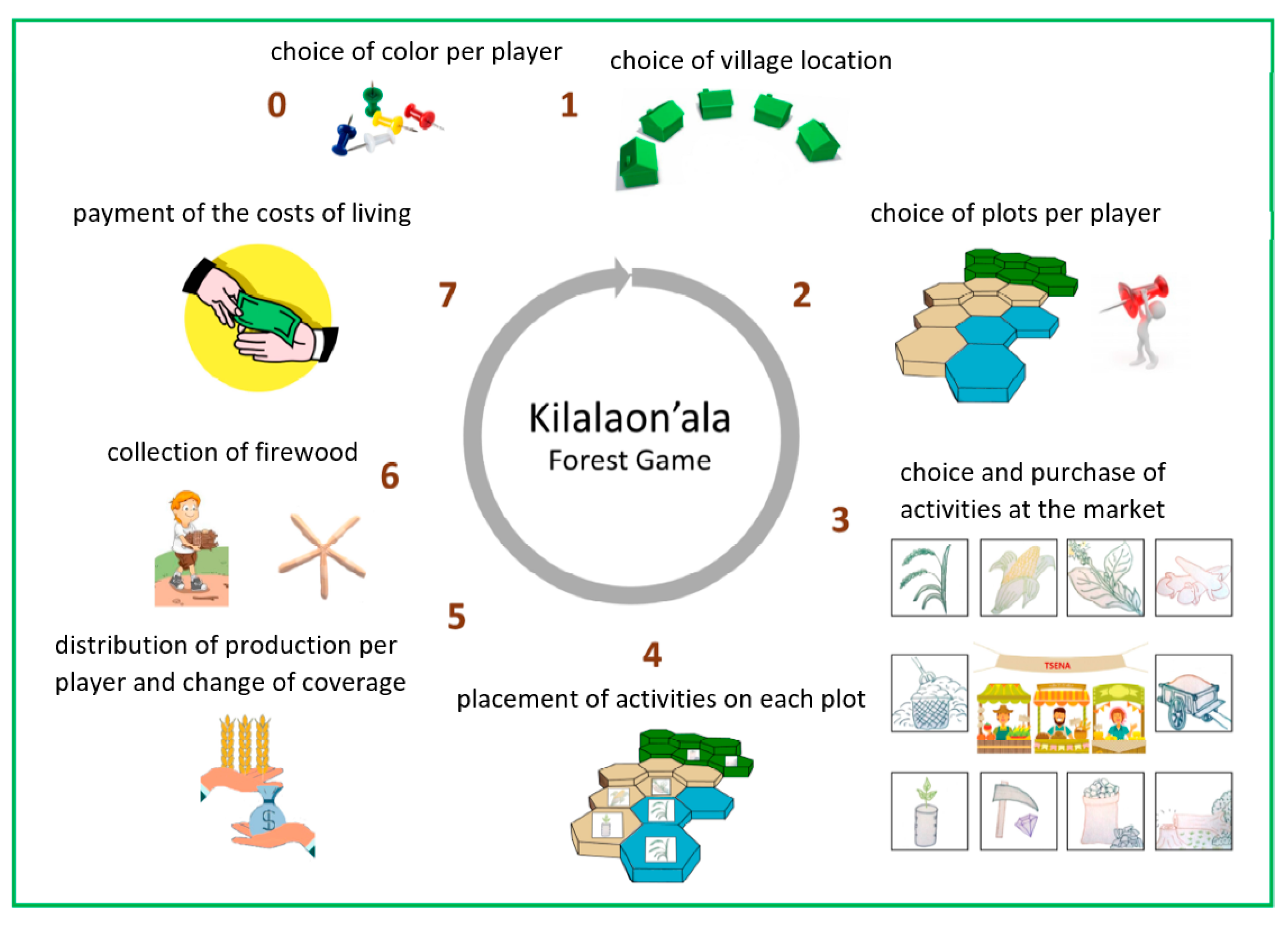
2.2.1. Development of an RPG

The development of a game consists of two main phases: a diagnostic phase and a gamification phase, which is the transformation of mental models into a game with a game board, rules, and players. The diagnostic phase served to identify actors, resources, dynamics, and interactions [37] of forest decline and land conversion. This diagnostic phase entailed a multitude of approaches including focus groups and interviews with different stakeholders, and ethno-photography of sciences (details on content and participant selection are specified in Appendix A.1). One of the photography methods used to collect these narratives was created for the project [51]. It was aimed at obtaining a corpus of visual narratives shared between the photographer (necessarily biased) and the people (or landscape) portrayed. During “iteration workshops”, a set of pictures taken during previous visits to the area were analyzed by the participants, and missing aspects identified by them were added afterward. The interactions between the participants and the photographer gave a complement of information by addressing the same issues as the scientific methods used, but from a collaborative and artistic perspective.
The obtained information was used to develop a mental model of the Zahamena socio-ecological system (SES) and to identify the dynamics in the system such as regrowth and fallow stages after burning and cultivation. These conceptual models served to develop the components and rules of the RPG (role-playing game; see a detailed description of the RPG used in this research in Appendix A.2): Actors were turned into players, resources into tokens, and dynamics into rules. After an extensive testing phase for calibration and parameterization based on stakeholder engagements (Appendix A.1), a total of six full-day workshops with 30 participants took place, where two scenarios were played with respective debriefings. Follow-up surveys were performed the day after. The research team facilitating a game workshop comprised four researchers sharing facilitation, note-taking, and game-updating tasks.
During a game, which consists of five rounds, five players make decisions on land-use activities to pursue their livelihoods. They can do a variety of activities such as agriculture (rice, maize, beans, tobacco, cassava, and clove) and use small or big amounts of fertilizer to improve outputs. Players can further invest in charcoal production, wood exploitation, mining, install firebreaks to prevent propagation of fires, and do reforestation. The game board (Figure A2) represents the typical forest-dominated Zahamena landscape. The goal for the players is to make a living, i.e., to be able to pay their household’s livelihood costs at the end of every round. How they achieve this depends on their personal preferences and decisions. The game has two scenarios, each consisting of five turns, representing five years each. The two different scenarios were developed to be able to observe and discuss different strategies and decisions based on different forest management regimes. In Scenario 1, all 35 forest plots of the “gamescape” (the game board representing the landscape) are state-owned. In Scenario 2, different governance systems underlie the forest plots: Three cells remain state forests, eight plots are under a community-based regime (VOI), and 24 cells represent the protected area (Zahamena National Park). We developed the two scenarios to explore and understand the impacts these different land management regimes may or may not have on the behavior, land use, and/or livelihood strategies of local people. A detailed description of the game components and functioning is provided in Appendix A.2.

2.2.2. Game Workshop Structure

One gaming workshop lasted a whole day: the game sessions for both scenarios were divided between morning and afternoon. After a brief introduction of the research team and the gaming approach, participant information was collected (gender, age, schooling, and livelihood activities). After explaining the course of the game to the players, scenario 1 was played, followed by a small debriefing discussion that addressed players’ feelings about the game and about results during the first scenario (what happened on the game board), reasons for the activities pursued or not (mostly in the forest), and the problems or constraints they encountered during the game. After a lunch break, the facilitator explained the landscape changes and new rules before playing scenario 2. The second debriefing contained additional aspects as compared to the first debriefing, including comparisons between scenarios 1 and 2, the adopted strategies for the different scenarios, the changes observable on the game board, and, most importantly, the transition to reality from what they see on the game board or what they encountered during the game. At the end of the workshop, follow-up surveys were scheduled for the next day, with the team visiting the individual participants at their homes to address additional questions surrounding daily life activities, forest management, landscape changes, and governance.

2.2.3. Game Workshop Participants

A total of 30 resource users participated in the six game workshops, conducted along the Vavatenina–Antanandava transect (Figure 1). Workshops 1–3 were conducted far away from Zahamena (over 1–2 days walking distance) in the district of Vavatenina, where there is almost no dense forest remaining. The forests available to these villages are only vestiges of forest-covered landscapes from long ago. Workshops 4–6 took place in villages close to the Zahamena forest block, in the commune of Antanandava, where people still have daily access to significant forest resources (from less than an hour to two hours walking distance from Zahamena National Park). The selection criteria for participants were (i) local residence, (ii) agriculture as main livelihood activity, and (iii) aged at least 18 years. Additionally, participants were not to be from the same households, and particular attention was paid to having a balanced gender representation.
At sites 1–4, participants were from the ethno-linguistic group of the Betsimisaraka, and, at sites 5 and 6, all players were a mix of Betsimisaraka and Sihanaka. Primary activities in sites 1–3 were cash crop cultivation (clove, coffee, and vanilla) and shifting rice cultivation, while the landscape was dominated by clove fields and savoka (seral stage of regeneration after slash-and-burning). There was only a small surface area suitable for irrigated rice. In sites 4–6, the primary occupation was farming of irrigated and rainfed rice, as well as bean and cassava production. The landscape was characterized by dense forest, savoka, and the presence of grasslands and wooded grasslands.
The age of participants ranged from 18 to 80 years (split in the following age categories: ≤20 (1); 21–30 (6); 31–40 (5); 41–50 (7); 51–60 (7); 61–70 (2); 71–80 (2)). Of the 21 men and nine women, the educational levels ranged from not identified (2), illiterate (2), primary level (14), secondary level (8), high school (3), to university (1).

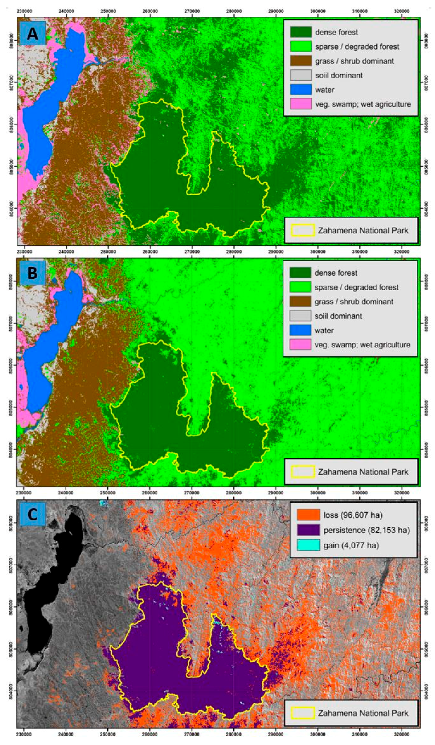
2.3. Land-Cover Mapping and Dynamics Assessment

For this article, we used Landsat imagery to identify real-world trends in forest cover change, and to allow for a comparison with landscape development in the game setting (one scenario representing 25 years). For this, we acquired two Landsat images from the United States Geological Survey (USGS) Earth Resources Observation and Science Center (Sioux Falls, SD, USA). The images provide coverage over the study area for 19 June 1990 and 24 August 2014 and were acquired atmospherically corrected to Level-2 surface reflectance [59]. Images were selected approximately 25 years apart, as constrained by cloud cover. While the 1990 image was cloud free, the best available image circa 2012–2016 contained some cloud-cover. Landsat data were selected as they are freely available, provide a moderate (i.e., 30-m) spatial resolution, and have a proven capacity for detecting forest cover disturbance [60]. An unsupervised iterative self-organizing classification algorithm (i.e., ISOCLUST; Clark Labs: Worcester, MA, USA) was used on the 2014 image to group pixels into dominant cover types based on their shared spectral properties and to target areas dominated by shadow and/or cloud. Areas dominated by cloud and the boundaries of the study area were applied as a mask to both dates of imagery.
Land-cover types were defined based on an aggregation and augmentation of existing categories (i.e., dense forest, degraded forest, wooded grassland, grassland, agriculture mosaic, rice agriculture, and water vegetated swamp) into spectrally discernible classes (i.e., dense forest, sparse/degraded forest, grass/shrub-dominant, soil-dominant, water, and vegetated swamp/wet agriculture (e.g., rice)). Examples of target land-cover categories were initially located with reference to ground data collected by the AlaReLa project in October 2015. Additional examples of target classes were located with reference to an existing national-level land-cover map (i.e., Reference [61]), fine-spatial-resolution satellite imagery viewable in Google Earth Pro, and the appearance/spectral values of the Landsat data. For all classes, training and testing sites were derived to calibrate and validate an image classification algorithm. The maximum-likelihood classification algorithm was selected given a proven track record for classifying different types of forest cover [62]. Resulting map accuracy was quantified using a confusion matrix to cross-tabulate with independent testing (i.e., validation) data. The Kappa index of agreement (KIA) assessed how better than random the map was [63]. Due to a lack of historical reference data, the 1990 classification was not validated. The mapping results were used to establish historic (i.e., 1990) and contemporary (i.e., 2014) forest extent and quantify dynamics (i.e., loss, persistence, and gain) from 1990 to 2014 using the Idrisi Land Change Modeler (Clark Labs, Worcester, MA, USA).

2.4. Analysis of Gaming and Debriefing Data

Before, during, and after the gaming sessions, various qualitative and quantitative data were collected. Qualitative data were participant statements, noted and audio-recorded during discussions and debriefings (as described in Section 2.2.2). We screened the obtained qualitative data for exemplary statements, i.e., to represent the range of different perceptions, strategies, and realities.
Quantitative data were collected with data sheets during both scenarios, and captured participant behavior and decisions such as type, number, and location of activity (cultivation of rice, maize, beans, tobacco, cassava, clove; use of small or big amounts of fertilizer; charcoal production, wood exploitation, mining, firebreak installation, and reforestation), as well as the consequences (production, i.e., income/livelihood and forest cover; see also Table A4 for detailed lists of variables measured during gaming).
For statistical analysis, livelihood and forest cover over time showed normally distributed errors. Therefore, we used two-sample t-tests to analyze the effect of the scenarios. To investigate the interactive effects of the scenario and workshop on these, we used linear models. All variables related to players’ strategies showed non-normal error distributions. Non-parametric Wilcoxon rank sum tests were, therefore, used to check for differences between scenarios. All analyses were done using the R software version 3.0.3. [64].

3. Results

This section is based on outcomes of the transdisciplinary approach described in the methodology section. In the first part of this section, we disentangle the interactions between stakeholders and their resources, and land-type dynamics, i.e., what are the responses of land-cover types to the interactions described. These results stem from the diagnostic phase, including interviews, surveys, and focus groups. In a second part, we juxtapose game outcomes (virtual world) with Landsat-based land-type dynamics and with outcomes from discussions (stemming either from debriefings, interviews, or focus group meetings), i.e., real-world perceptions of the stakeholders. When quotes are used, a code indicates their origin (FG = focus group, I = interview, W = (game) workshop, and P = player).

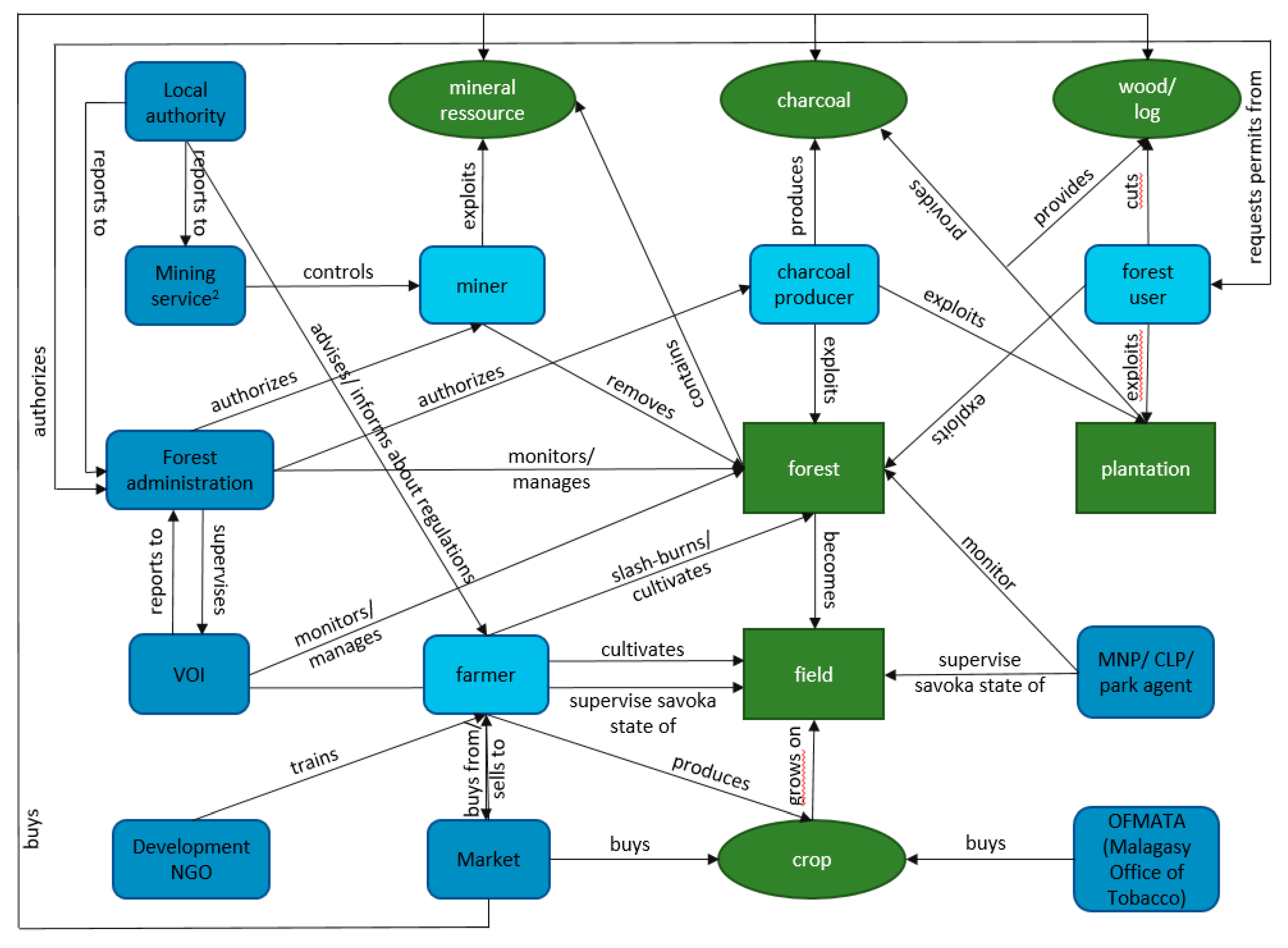
3.1. Understanding the Socio-Ecological System

3.1.1. Interactions of Actors and Resources

The main local actors in the socio-ecological system of the Zahamena region are farmers, charcoal producers, and miners, as well as institutional actors such as the Forest Administration, mining service, traditional authorities, and NGOs. Different forms of land use, such as wood exploitation or the establishment of farmland, transform dense forest into other land-use forms and provide cash crop and food crop to the local population. Authorities and institutions mainly hold indirect roles in supervising resource use and the application of laws (Figure 2).

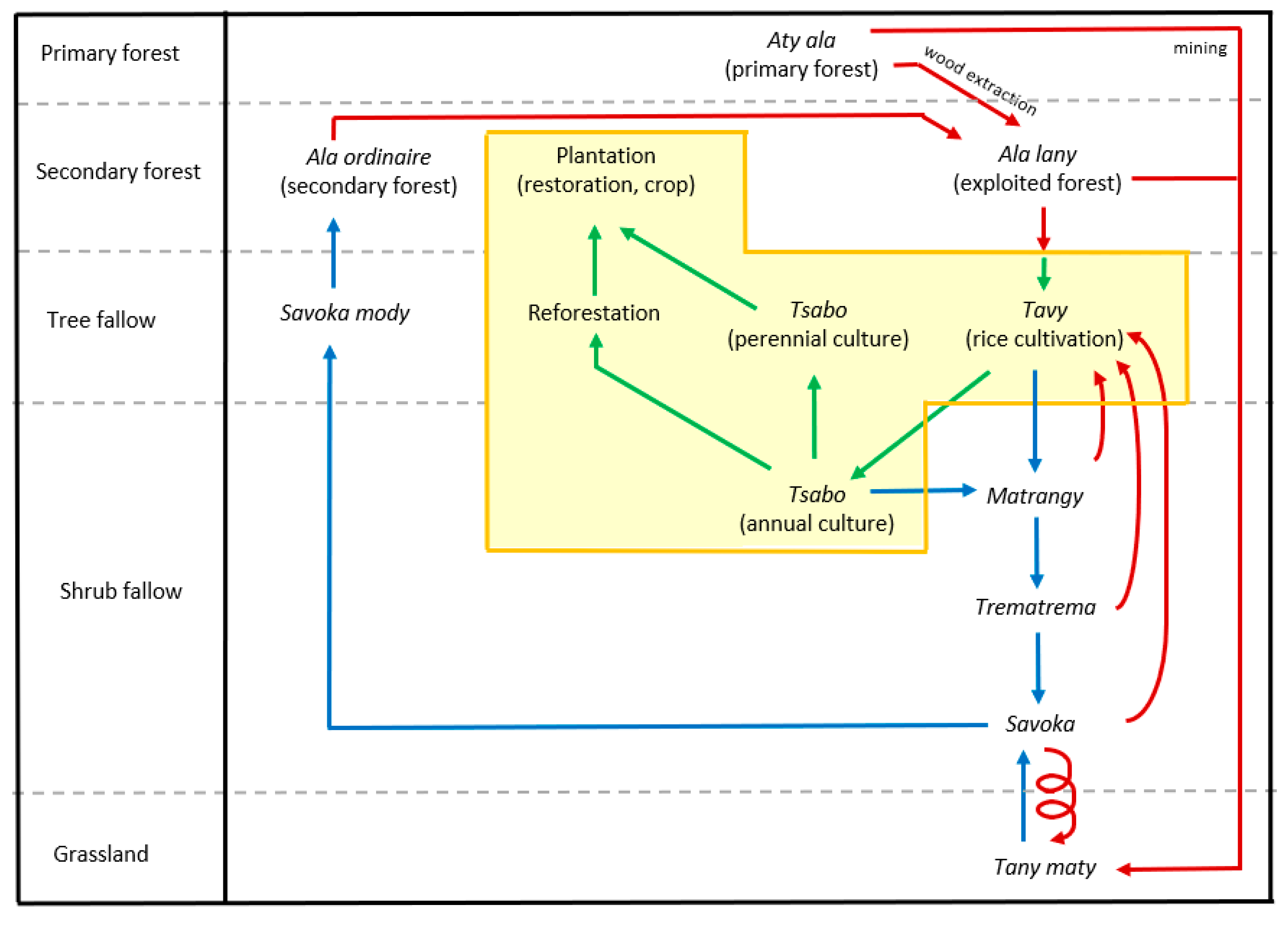
3.1.2. Land-Type Dynamics

Dense forests turn into ala lany (exploited forest) when precious woods and construction timber are harvested. When farmers establish fields for farming, forest is burned, mostly by practicing tavy (slash-and-burn agriculture). Amongst Betsimisaraka, tavy is also the name of the resulting field that is used for rice cultivation or a mixed culture consisting of rice (the main crop) and beans or corn. In the second year, farmers have the choice to either cultivate rice or mixed culture once more, or another annual culture such as maize or cassava, or a perennial culture such as coffee, clove, or litchi. Betsimisaraka use the word tsabo for rain-fed crops (annual or perennial, except for rice) and for the terrain these grow on. Tsabo does not require burning to prepare the ground for cultivation; a simple exposure of the superficial part of the soil (kapakapa) or a light ploughing similar to the system of cultivation under vegetal cover is enough. In contrast, a burn always precedes the tavy, and as the farmers usually do not use fertilizer, rice is cultivated in the first year when soil fertility is highest (Figure 3).
After three or four years of cultivation, farmers leave the plot fallow for at least three years and then redo the tavy to cultivate it again. Generally, farmers only plant perennial crops such as cloves once the quality of the soil diminishes and no longer gives a satisfactory annual crop production, particularly if they do not have much land. When fields are no longer cultivated, different fallow stages follow, such as matrangy in the first year of regeneration (1–2 years), trematrema with higher vegetation (2–15 years), and savoka with high and dense vegetation, including woody vegetation (3–15 years). After 10–20 years, savoka mody develops, which turns into secondary forest after (20–)50–60 years (time data from field work and Reference [21]). This secondary forest can then form the starting point for a new cycle (Figure 3). Restoration is also a possibility. While this leads to the development of plantations, annual cultures enter the fallow cycle, unless they are cultivated again. If burning cycles move closer together, i.e., fallows are no longer allowed or are burned at an earlier stage than savoka, the risk that the terrain becomes uncultivable (tany maty) increases. This also happens after mining, when the nutritious layers of the soil are removed or dislocated.

3.2. Forest Change, Livelihood Challenges, and Governance

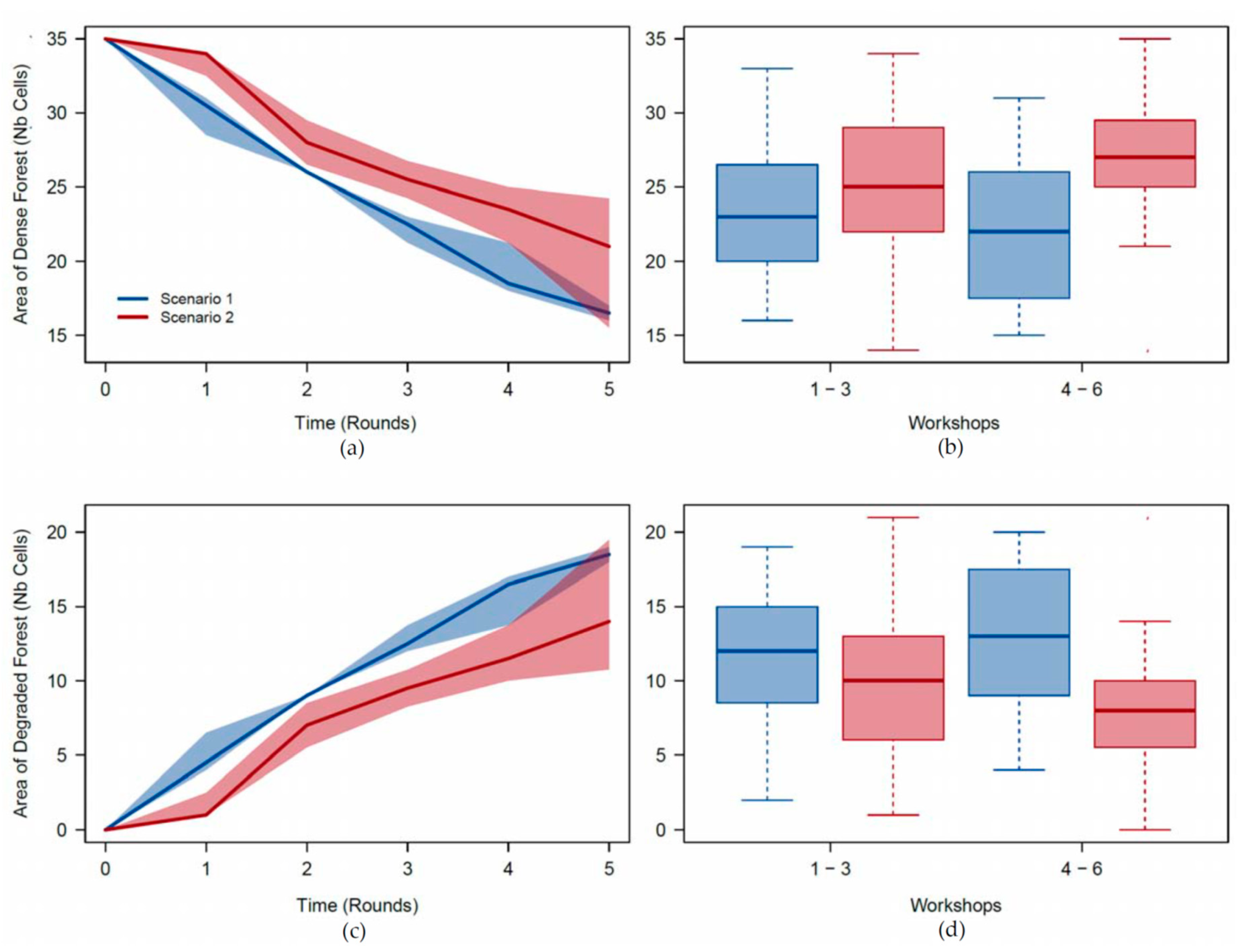
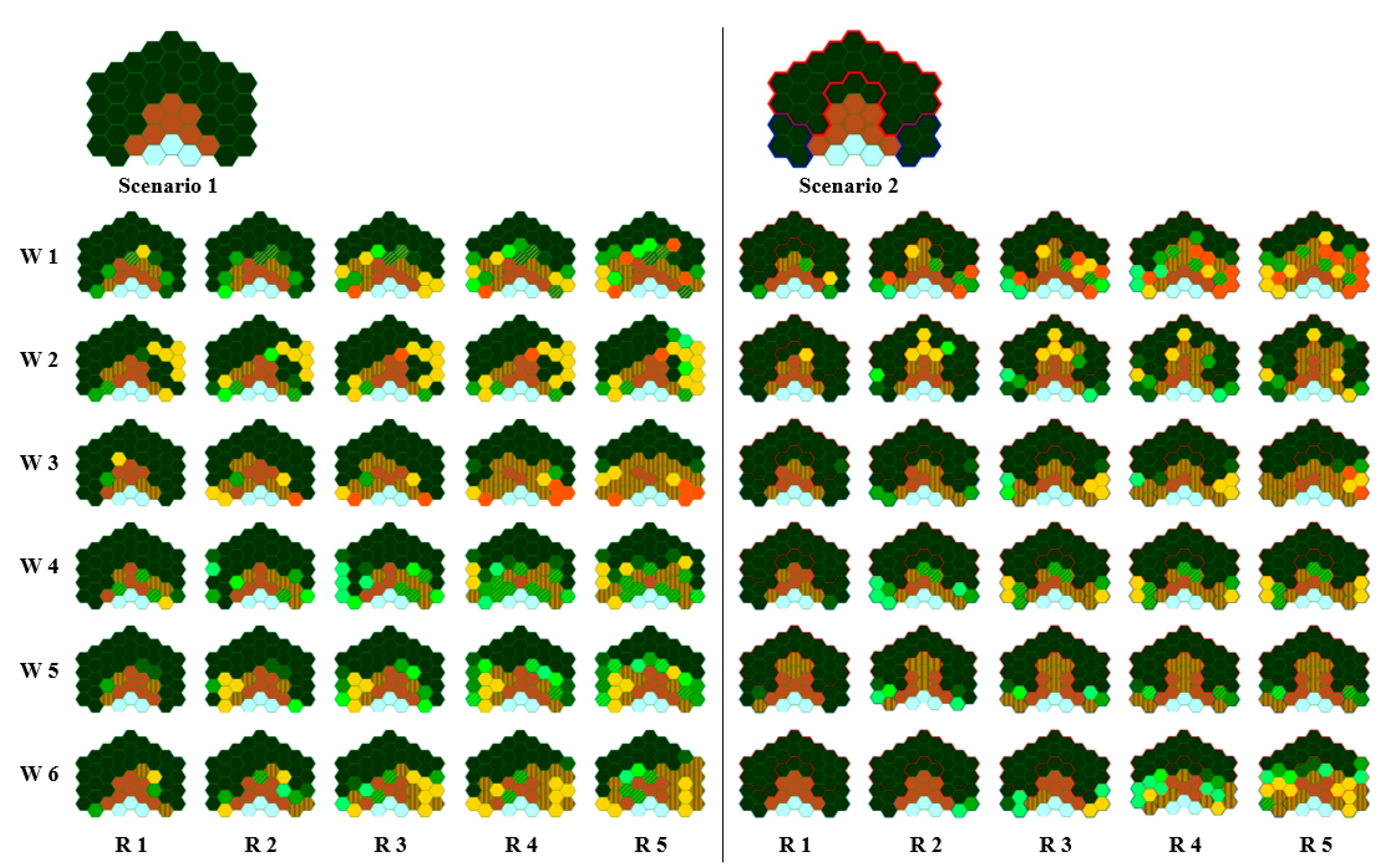
3.2.1. Virtual World—Gaming

Though the game represents an artificial world, it still has meaning to the players. Impacts of actions and decisions on how to use (or not use) a land unit are directly visualized on the game board (Figure 4).
Players’ gaming behavior and its impacts were statistically analyzed. Testing for differences in livelihood and the state of the forest revealed several results. Between scenario 1 and scenario 2, there is a statistically significant difference in the amount of degraded natural forest (more in Scenario 1; Figure 5, Table A4), comprising all forest degradation levels summed together, but not in livelihood. Testing for differences in game activities showed a statistically significant difference between scenario 1 and 2 only in six out of 40 variables (Table A5). However, when testing for differences between workshops 1–3 (situated far from dense forest) and 4–6 (close to dense forest), many variables showed a statistical difference; there were significant differences in livelihood (much higher in W4–6), moderately degraded forest (more in W1–3), very degraded dense forest (more in W1–3), and completely deforested plots (more in W4–6; Table A4). Of the 40 game activity variables, 26 were tested to be significantly different between forest-close and forest-distant workshops (Table A6). When testing for the effect of interactions between the scenario and workshop on land, there was, on average, a significant difference between scenarios 1 and 2, and a slight but non-significant difference between workshops 1–3 and 4–6. There was more dense forest, and less degraded forest in scenario 2 than in scenario 1, and this difference intensified slightly for workshops 4–6. Indeed, in workshops 4–6, there was a bit more forest and a bit less degraded forest in scenario 2 than in workshops 1–3 (Figure 5).
Participants of the game workshops stated that they based their gaming behavior mainly on daily life (67%), gaming rules (17%), and on what others did in the game (10%). The rest did not give a reply (6%). Some players added remarks, for example, that the use of fertilizer is not yet common and is rarely done, that activities like cloves are not yet practiced in the sites of the commune of Antanandava (W4–6), and that the exploitation of forest resources for commercial purposes—selective cutting, charcoal production, and mining—is not very frequent. During the game, players have to establish strategies and make decisions regarding which activities to pursue, including the adherence or non-compliance to management rules and laws. Below, discussion outcomes from the debriefing sessions are presented in relation to forest exploitation activities during the game sessions.
The most common reasons for not undertaking charcoal production were the difficulty in obtaining a permit and the fear of being punished.
“I did not produce charcoal for fear of exploiting the forest.” (game workshop participant W1P5)
“Even when following (the law), it is difficult to obtain a permit.” (W6P5)
Other players did not use the forest [selective cutting] because they lacked permits and/or feared law enforcement.
“This activity requires authorization but I did not have enough money to apply for a permit and was stopped by forest protection.” (W4P5)
“I exploited the forest but stopped after being fined by the Forest Administration.” (W2P3)
“I thought about it [mining], and then I thought maybe I need authorization from the chef de cantonnement and the mining department, but I did not have enough money to start the process.” (W4P5)
Reasons for exploiting the forest were mainly income and the development of arable land.
“I cut wood to earn a lot of money.” (W2P2)
“To extend cultivable land.” (W6P4)
“I have a cutting permit but I have also made illegal cuts.” (W4P1)
“Mining can earn you a lot of money if you are lucky.” (W2P2)
“I waited until the plot was completely deforested before mining.” (W1P2)
The establishment of the protected area in scenario 2 shifted the focus of cultivation to the VOI forests; however, these could not fully cover the needs of the players in the long run, and, once these were exhausted, the neighboring forest cells were increasingly exploited and transformed into farmland.
“The land is not enough, the community forest has been exhausted, the parcels of forest in the park are close to the lands already developed…so I still used the parcels of the park.” (W3P3)
“The land is not enough; we had to expand farmland. Also, the number of dependents [members of household] continues to increase.” (this participant still used the parcels of the park; W3P5)
“When the VOI forest was completely destroyed, it was necessary to enter the protected area. The degradation is done continuously starting from the parcels closest to those already used.” (W5P4)
“We must be cautious about the use of reserve [protected areas] resources because even if we follow the law, we do not obtain authorization.” (W6P5)

3.2.2. Land-Cover Mapping and Dynamics Assessment

Mapping and dynamics results indicate a general and widespread decrease in dense forest and an increase in sparse/degraded forest (Figure 6). Within the study area, from 1990–2014, approximately 96,607 ha of dense forest was lost, 82,153 ha remained unchanged (i.e., persistence), and 4077 ha were gained. Dense forest primarily transitioned to sparse/degraded forest but also to grass/shrub-dominant and agricultural land-use areas. Dense forest loss occurred almost entirely outside the boundaries of the Zahamena National Park. According to the confusion matrix (Table A7), the 2014 classification resulted in a highly accurate map, with an overall accuracy of 99.6% and a KIA of 0.99.

3.2.3. Real World—Land-Use Narratives and Perceptions

Land-use characterizations allow for a better understanding of local realities, and thus, an improved understanding of gaming results. This section provides detailed insights into individual realities and general livelihood strategies, based on discussions during interviews, game workshop debriefings, follow-up surveys to the game workshops, and focus groups.
The majority of people do not produce their own charcoal, but collect firewood. People closer to the Zahamena National Park realize that finding firewood requires more and more walking due to ongoing deforestation when compared to 20 to 30 years ago; even the degraded forests are not producing enough firewood anymore. People blame the growing population for this situation. For example, the woman selling charcoal (Figure 7) walks about three hours every day from her home to the charcoal production site, then three hours with the charcoal bag on top of her head to the market in Andreba-Gare where she stays until she has sold all the charcoal. One stack of charcoal costs about 100 Ariary (Ar; 0.03 €). The walk back home is also about three hours. Families produce charcoal for the market, where a bag of charcoal costs around 7000 Ar (1.83 €). Firewood collection in dense and degraded forests was free; in recent times, people started selling firewood produced on their plantations. Clove production is very common on the eastern side of Zahamena (district of Vavatenina), where many households possess clove trees. These were introduced by the French colonial powers together with coffee, vanilla, and litchi. It takes seven years for the first production of cloves, and mature trees produce cloves every 2–3 years. The trees are also appreciated for their leaves, which are used for essential oil production during lean periods (Figure 7).
“Growing vanilla and cloves is a good alternative [to rice production or mining], as these two crops can bring in lots of money.” (Interviewee I6, Antanandava)
“Before, we grew nothing but rice, but then the foreign foremen taught us how to grow cloves, coffee, and vanilla, and we continued.” (W3P1)
“Clove is allotted for export, it generates money even with a small production.” (W4P1)
Dense forests are not only disturbed by the actual mining, which involves heavy use of water and digging (Figure 7), but also by deforestation linked to miners’ subsistence (e.g., tavy for crop and clearing of land for housing; see statements in Appendix A.3). While the RPG offered the opportunity for researchers and locals to explore different management scenarios, the follow-up survey after the game workshops served as a tie to the real world, allowing the elicitation of perceptions of forest governance and enforcement bodies (see also Appendix A.4 and Appendix A.5). The statements stem from the survey questionnaires, and they all relate to the real world (not the game). When players were asked about their opinion regarding the state of forests if there was no protected area, the majority indicated that it would be worse without such a governance system, and that the existence of VOIs prevented people from exploiting forest in the protected area, but only as long as these provided sufficient output. The presence of enforcement bodies was also judged influential. The consensus amongst the game workshop participants was that local management would still be best suited to serve the local population, who has livelihood security as the highest priority.
Perceptions of forest users on forest governance in real life:
“All forest may be destroyed but the park would be used as last recourse.” (W1P3)
“As long as there is no manager, people always take advantage of it to clear the forest in secret. Also, the chef de cantonnement only comes very rarely.” (W2P3)
“We are so afraid to enter and use the forest, whatever its status, but we still dare because a lack of options.” (W4P1)
“Communities first use the VOI forest and once it is fully depleted, communities will be forced into the protected area as they need to use the forest and its resources.” (W4P2)
“If there are only state forests and the park, the state forests will be degraded first. On the other hand, the presence of forests managed by communities prevents them from entering the reserve.” (W5P4)
“If there is nobody in charge at the local level, the forest will be destroyed, even in the protected area, starting from the outside.” (W6P4)
The principal problems players observe in forest management in the real world are mostly related to (mis)communication, the fuzziness of responsibilities, and the lack of power.
“ANGAP (new MNP) does not allow the local population to enter the park, but the staff enter the park to harvest the wood and sell it. Only ANGAP staff benefit from the Park’s presence and there are no tangible benefits to the communities. If there are people from the riparian community who want to harvest or cut, they do not get authorization, yet the big exploiters do not have that problem. In sum, the Zahamena forest is protected but there is no consideration of the subsistence of the population.” (W4P5)
“For the VOI forest: It is the people outside the local communities and the leaders who actually manage and exploit the forest. As far as the Park is concerned, it is an NGO that manages it with foreigners, which is why the forest is protected. If we let the Malagasy manage, the degradation could not be prevented.” (W4P1)
“There is not enough collaboration and support from ANGAP and the chef de cantonnement. For example, the construction of a dam for agriculture, so that communities are obliged to progressively expand their fields for cultivation on the edges of forests.” (W5P5)
“There is not enough communication with local people from forest management.” (W6P4)
“The institution of the VOI is nothing but a name; it has no management power. If people with an authorization from the chef de cantonnement come to exploit, the VOI remains powerless. If people change their land to cultivate, the reason is that the soil of the plots they used until then are no longer productive. Exploitable lowlands for irrigated rice cultivation exist but without a dam, farmers prefer to exploit forests.” (W6P5)

4. Discussion

In Madagascar, the impacts of policies to involve local resources users in forest management remain unclear. This study explored farmers’ perceptions and practices regarding forest use under various forest governance systems with the help of a role-playing game and accompanying research.
The land-cover mapping results indicated that during the past 25 to 30 years—since the inception of the National Environmental Action Plan (NEAP)—deforestation of dense forests or their transformation into degraded or other land-cover types led to a loss of almost 100,000 hectares in the Zahamena area. While the general trend of transition from dense to sparse/degraded forest is readily apparent and easily explained, the less dominant transitions and interplay between other land-cover categories requires further efforts for more robust, thorough, and tangible context. For example, there is an increase in sparse/degraded forest observable in the western portion of the study area beyond the borders of the Zahamena National Park. This transition from grass/shrub-dominant areas and those dominated by wet agriculture to sparsely forested areas, while possible, requires further investigation, confirmation, and explanation. Despite the accuracy of the mapping results, the maps resulting from this study and their associated dynamics should be considered preliminary. Additional ground reference is required to further refine class definitions, provide additional examples of all targeted categories, and ultimately help contextualize all observed transitions. Bearing in mind the uncertainty associated with less common and more subtle changes, it is clear that, overall, throughout the study area, there was a substantial shift from dense to sparse/degraded forest, and that the vast majority of this change occurred beyond the boundaries of the Zahamena National Park. In addition to overall loss, mapping and dynamics results illustrate that areas of continuous dense forest already had wedges of sparse/degraded forest in 1990, which, in many areas, were since enlarged and completely cleared of dense forest. This trend supports the findings of Reference [11], which showed that almost half of Madagascar’s forests are now located less than 100 km from a forest edge. A problem that should not remain ignored is the loss of forest quality (cf. Reference [65] linking fragmentation and biodiversity loss). Globally, focus has been to date on forest lost, but studies like Reference [66] highlight that loss of forest quality is under-researched in the Brazilian Amazon, contributing to much larger-scaled losses having so far gone undetected.
Our study showed that deforestation is taking place in both scenarios, while forest quality loss could be slowed down in the second scenario through different layers of governance, with some players mentioning being hesitant to enter the protected area. Though there was no difference between the two scenarios for most variables, it was interesting to see that there were more significant differences between the workshops far from the forests versus the ones close to Zahamena. This is not a coincidence, as distance to resources was shown to play an important role, as found for example by Reference [67] in the context of lemurs and the protected area at Lake Alaotra, a wetland complex just west of Zahamena. Similarly, Reference [24] depicted that people were more attached to forests in Manompana, some 200 km to the north of Zahamena, when living closer to forest edges. In our game, people closer to the Zahamena protected area did deforest and degrade forest less than those from the Vavatenina (eastern Zahamena) side. One reason could be that people living close to forests “care” more since they see the obvious benefits of having forests as a livelihood resource (e.g., References [25,68]). Or, people living further away may have already “forgotten” the forests, as most of the bigger forest vestiges were cleared off more than a generation ago.
While a number of studies documented that forest governance is not working due to a combination of lack of financial, human, and technical resources [37,69,70], it remains unclear what exactly is not working. In addition to these resource shortages, there are also those assigning fault to an incompatibility and a misalignment between village managers and the Forest Administration—an issue highlighted during the interviews conducted in this study, where local participants expressed their frustration about the power dynamics at play. Pascual and colleagues [71] put forward the crucial importance of equity when developing and implementing payments for ecosystem services. Power imbalances that are not taken into account during the design phase of instruments, and a lack of cultural and social consideration were shown to influence ecological outcomes. Here, we gained deeper insight from farmers’ (rural resource users’) perspectives. One main aspect related to governance emerged during the game workshops: the fear of crossing boundaries, i.e., the fear of fines from the state authorities. In the game, the Forest Administration was represented by a member of the workshop organizers positioned “far away” from the main game table. During a full game session, he/she was seldom visited, since most players did not believe they would receive proper support or the right permits. However, the presence of the Forest Administration, or the knowledge of its existence, was reason enough to slow down the crossing of the park boundaries in the game. Only when the population pressure grew bigger and livelihood needs were more difficult to satisfy did people start entering the protected area. At the end of each round, every household grew by one family member, which translated into a doubling of the household, and therefore, of the total population. This mechanism was implemented intentionally to reflect the reality of the Zahamena area.
The biggest concern for all game workshop participants was livelihood security. Land represents the biggest investment, and forests are seen by many as a reservoir for future agricultural production, since agricultural production—annual crops or cash crop production—is the sole way of ensuring subsistence and/or creating additional income. During the game, participants first tried to meet their livelihood needs outside forests, and supplement this with activities within forests. The first occupied forest parcels were those managed by the local communities (VOIs). Reasons for this were that the parcels were seen as belonging to them; therefore, they feared no consequences despite the risk of breaking the local laws (dina), or that possible fines issued by VOI members would be less severe than in the case of parcels under the management of the Forest Administration.
As confirmed in this study, VOI representatives lack authoritative power, as social bonds are de facto suppressing efficient law enforcement [72,73]. A central problem revolving around community-based natural resource management (CBNRM) is the use of the term “community”. As already stated by Berkes [74], communities are not homogeneous entities, but consist once again of a large number of different interest groups and power relations. This can hamper any community-based initiatives, be it in a governance or conservation context (e.g., Reference [75]). In Antanandava, between 4% and 82% of households adhere to the local VOIs (1–23% of the local population), and most VOIs are yet to receive their official contracts for management transfer, due to a lack of funds to undertake the necessary evaluation for contract renewal. This abeyance is causing further conflicts in forest management including mismanagement, illicit exploitation, threats against VOI members (as also known from other sites), and conflicts within the associations.
In the Zahamena area, VOI-managed forests, i.e., under a CBNRM regime, are the first to be depleted. A majority of the VOIs around the Zahamena currently do not have a proper status: Either they were signed in to the GELOSE but their contracts expired and are awaiting renewal, or they are awaiting signing since the GELOSE enactment. In both cases, there is de facto no functional VOI, and thus, the communities do not respect any leaders of these associations. There is a general mistrust in authorities, starting at the VOI level where community members blame those in charge of abusing their power and knowledge. This translates up the authoritative ladder to the Forest Administration and the MNP. Another issue is the quality of reporting (or lack thereof) by the VOI to the Forest Administration. Community members in charge are either not used to writing reports, or the Forest Administration agents do not understand what the locals are reporting, and thus, ignore their messages. Adding to this is the lack of monitoring from the Forest Administration side, which is supposed to ensure that the VOIs are functional. The current under-staffing of the Forest Administration and the MNP, however, does not allow ensuring the VOI’s functionality.
In our research, participants of the game workshops found that real-life issues were clearly reflected. Nevertheless, games are “only” models, and thus, have their limitations (e.g., Reference [76]). They are not about forecasting or anticipating futures; rather, they are about providing discussion platforms. Gaming is an extremely powerful tool to do so. Role-playing games allow one to recognize reality, and to discuss, explore, and experience different potential management regimes, future scenarios, or climate changes and their respective implications—while being distant enough from reality to learn and exchange in a safe environment. RPGs are not just models reflecting more or less detailed versions of reality; more importantly, they are fun and allow participants to forget their day-to-day struggles. This enjoyment also means that engagement is high, and discussions are more meaningful because participants feel personally involved. The game workshops represent a “safe space” where people are able to freely discuss and voice issues, concerns, and critiques, when there is usually a fear of repercussion. Bridging the virtual and real world is facilitated by the gamescape (game board) and subsequent debriefing discussions [77]. These settings allow the participants to explore their own livelihood situation, and enable them to visualize what their individual decisions, e.g., the “household level” in the game, may have at the landscape level. In another game (the Alaotra wetland game) [78], several players mentioned that the context of the game workshop was the first time that they actually looked at the system as a whole. This gave them the opportunity to think not only within their respective “space of activity” (e.g., their piece of land in the marshes), but to think and experience the connectedness and linkages of all the zones in the landscape. For researchers, tracking the decision clues, such as type, frequency, and spacing of activities, increased the understanding of livelihood strategies of the main actors in the Alaotra wetland [78]. Projects like AlaReLa (Alaotra Resilience Landscapes, 2014–2017) bring together various stakeholders by participating in games such as the one presented in this study to explore possible future scenarios. Doing so can help strengthen these stakeholders’ capacity to better cope with changes and future shocks (e.g., Reference [79]). In the long run, this might help regional decision-makers to better balance conservation and development goals, and it might ease local communities into becoming a more integrated part of the decision-making process. As stated by Reference [80] (p. 101), “Economic and financial policies have not provided much support…reflecting in part the very low political weight of the rural and farming population.” The game approach is certainly not a panacea, but it allows engaging with various stakeholders that, structurally, would otherwise not have the chance to voice their experiences.

5. Conclusions

This study was interested in exploring farmers’ perceptions and practices in the light of CBNRM at the local scale using a case study in the Zahamena region of Madagascar, as well as providing local perspectives on existing livelihood–forest dynamics. The National Park of Zahamena suffered from deforestation and degradation, mainly in the northeast, while the remaining park boundaries are mostly respected by surrounding communities. This shows that the protected area does have an effect—if only slowing down deforestation and degradation. In that light, even community-based and managed forests play a precise role of buffer forests, able to absorb the first larger wave of anthropogenic pressures. However, once these are depleted, no park boundaries will be able to halt people in search of subsistence. CBNRM may be a short-term solution, but it is not a sustainable stand-alone one (cf. Reference [81]). Given the complexity of current forest governance, the solution cannot be imposed top-down, as pushed by the international community in the 1990s decentralization effort. Boundaries will be ineffective as long as people’s livelihood situation is not improved. The only option for the majority of rural resource users is to transform any land they can access. Without access to better education, agriculture is their only guarantee of survival. Thus, long-term solutions for forest conservation needs to come from outside of forests—from agriculture. Although currently a global driver of deforestation, improved and sustainable agriculture could allow land users to increase their per capita and land unit production (e.g., References [82,83,84]). This could come in the form of access to new tools, techniques, and land-use rights. However, this bares two important risks. Firstly, despite better production, people will deforest even faster and more efficiently, and/or, secondly, any new agricultural development program will not be accepted and embodied by the local population—as is the current case with VOIs—while further deforestation takes place. Thus, participatory gaming approaches have the potential to help the rural poor by opening up opportunities for knowledge exchange, developing shared understandings through the elicitation of mental models that juxtapose multiple worldviews, and by exploring different possible futures.

Author Contributions

Conceptualization, P.O.W. and L.M.R. Methodology, N.B., L.M.R., A.D.G., N.S., and P.O.W. Validation, N.B., A.R., H.V.F.R., and T.R. Formal analysis, J.C., T.G.J., and G.M. Investigation, N.B., H.V.F.R., T.R., A.R., N.S., and A.D.G. Data curation, L.M.R., G.M., and J.C. Writing—original draft preparation, P.O.W., L.M.R., N.B., and N.S. Writing—review and editing, N.S., C.G., B.S.R., and L.W. Visualization, L.M.R., J.C., N.B., and T.G.J. Supervision, P.O.W. Project administration, P.O.W. Funding acquisition, P.O.W. and C.G.

Funding

This research was funded by the Swiss Program for Research on Global Issues for Development under the research grant number IZ01Z0_146852.

Acknowledgments

The authors thank all authorities from the Alaotra Mangoro Region who supported and participated in our research. We further thank all farmers and further stakeholders for their trust and participation in this study. Our acknowledgements are extended to our research assistants on the ground and to the two anonymous reviewers and editor for their helpful comments on a former version of the manuscript. This research was funded by the Swiss Programme for Research on Global Issues for Development under research grant IZ01Z0_146852 as part of the AlaReLa Alaotra Resilience Landscape project.

Conflicts of Interest

The authors declare no conflicts of interest. The funders had no role in the design of the study; in the collection, analyses, or interpretation of data; in the writing of the manuscript, and in the decision to publish the results.

Appendix A

Appendix A.1. Approaches Used during the Game Development Process

All research described in this publication followed the ethical code of conduct and recommendations by Wilmé and colleagues [85], i.e., all participants were ensured anonymity and confidentiality unless wished differently from the participants themselves.

Appendix A.1.1. Diagnosis Phase

The game development was informed by results from ten focus groups (42 local participants) and eight expert interviews with local and regional authorities from the Municipalities, Forest Administration, and MNP (Madagascar National Parks). Additionally, this phase was complemented with interviews with local resource users, mainly farmers (n = 36), miners (n = 30), and further authorities (n = 17), to triangulate and verify the output of the focus groups—including ethno-photography of sciences (for an explanation, see page 6 of the manuscript).
In a first step, three focus groups were conducted in the respective villages tackling different but complementary themes: (i) types of land use and land status; (ii) land-use rights and rules for each type of land use; (iii) VOI functioning and rules of land use and forest use (mainly those assigned to the management of VOI).
Participant selection for focus groups (FG) 1 and 2 was based on the following criteria: (i) main activity in agriculture; (ii) aged 20–60, (iii) origin (locals and migrants); (iv) gender balance; (v) familiarity with the practices and rules applied in the fokontany (village); and (vi) belonging to different households. For FG3, the presence of simple VOI members was intended as their views on the rules on the use of forest resources in practice and the roles actually played by VOIs, as well as their personal position to that, could be different from those of the bureau members. The criteria were communicated to the chief fokontany or village chief and he was in charge of finding the participants.
Table A1. Details on the focus groups (FG) of the diagnostic phase. VOI means vondron’olona ifotony, being an association of rural stakeholders involved in natural resource management.
ParametersFocus Group 1Focus Group 2Focus Group 3
TopicIdentification of land-cover types: characteristics, the existing and used resources.
Land tenure dynamics.
Land tenure rules for each land use:
rules and rights in force (who can do what, where does this right come from, what are the problems/conflicts encountered, etc.).
Land acquisition patterns and types of land transactions.
Evolution of rules over time and space.
Role and function of VOI in forest tenure.
Views of VOIs on the use of forests and community mgmt.
VOI links with the forestry administration and the NPM.
Participants4: 2 men and 2 women6: 3 men and 3 women4: 2 office members maximum
AgeBelonging to different age groups: young people (20 to 30 years) and adults
OriginResidentsAutochthonous and migrants-
Main activityAgricultureAgriculture-
OthersKnowing the reality in the fokontany (village), able to discuss in group
The interviews were mainly used to complement and cross-check the information obtained during the FGs and also to gather the views of key informants, i.e., public authorities at the commune level and forest managers at regional or district level.
Table A2. Details on the interviews with regional and local authorities.
Authority (n = 8)Interview Topics
Fokontany (village) chiefs, or their assistants
Knowledge and application of land and forest laws by the fokontany
Roles and implications of fokontany in land matters and use of different forest types
Sector Head of Zahamena National Park
History of Zahamena National Park
The rules and laws in force
NPM interventions in park management and surrounding crop plots
Offenses and infringements encountered, problems
Involvement of local communities in management
Forest managers (Head of Forestry, Director DREEF Alaotra-Mangoro)
Rules and laws in force concerning forests
Procedures to be followed for forest resource uses
Situation/problems of management transfer to VOI
The main offenses and infringements encountered
Land Office Agent Antanandava and Deputy Mayor
Role of the land office
Mode of land acquisition and land security in the locality
Service domain
Mode of accession to land
Land transfer procedures
Flaws in land management and problems faced by the service
Table A3. Details on stakeholders and approaches that further complemented the above-described ones; VOI means vondron’olona ifotony, being an association of rural stakeholders involved in natural resource management; NP means National Park.
Participants and ApproachTopicsDetails
Authority interviews
(n = 17)
Main sources of income of the population
Main uses of the open landscape (in terms of agriculture)
Problems related to tavy (slash and burn) practices
Circuit flow of agricultural products and market problems *
Mayor and Deputy Mayors of the communes Ambohijanahary, Antanandava, and Vavatenina
Agricultural Service Center of Vavatenina
President of Water Users around Lake Alaotra
Presidents of the VOI of Antanandava
Chief sectors responsible for the conservation of the NP Zahamena-Antanadava and head of the conservation component of the NP at Fénérive Est
Miner interviews
(n = 30)
Participants’ perceived impacts of mining, on a personal and community level **The village heads helped in the search for miner participants, in order to follow the cultural etiquette.
Farmer ARDI
(n = 19)
Problem definition
Main actors involved
Resources needed for this use: land tenure, existing labor management systems
Dynamic: ecological changes and dynamics on the evolution of forest cover, open and swampy landscapes
In three workshops; village heads helped in the search for suitable participants.
Ethno-photography of sciencesWhat is your landscape? Which aspects are missing in the presented pictures/should we include and why?Random selection on village markets; criteria: natural resource users and village residents
* For a detailed account on this, see Ravaka and colleagues [86]. ** For a detailed presentation of farmers’ perceptions on mining, see Stoudmann and colleagues [87].

Appendix A.1.2. Game Development and Calibration Phase

The RPG was then tested and adapted during 11 workshops with 60 participants (university students from the forestry department in Antananarivo, natural resource users from the study area, conservation NGOs from the Alaotra, and Forest Administration members). Another nine workshops with 45 participants (all natural resource users from the study area) served to calibrate the game. Calibration was based on implicit reality, where game components and activities were still meaningful to the players. A final test workshop with villagers living close to the Zahamena forest helped to structure and fine-tune the actual data collection workshops.
For field workshops during the development and calibration phase of the game, the main criteria for selecting participants were as follows: living in the village, subsistence activity based on agriculture and not having played the game before, and gender balance whenever possible.

Appendix A.2. Game Description of the Zahamena RPG

The course of the game was the same for both scenarios. At the beginning of each scenario, the general course and the rules of the game were explained with the help of a poster that was displayed in the room (Figure A1). The five players each chose a color and receive a colored badge with a corresponding number, as well as same colored pins (game tokens to mark their plots) so that the research team could easily follow their activities. Each player represented one household, and received a starting capital of 2500 game money. They then consulted together for about two minutes to define the location of their village and mark the chosen parcel with small houses that were given to them.
Figure A1. Course of the forest game. This poster illustration was used to explain the general course and rules of the game to the players.
Forests 09 00624 g0a1
Players could then start investing their money at the market to receive seeds and compost, and to do activities on the game board; prices of the activities on the market were displayed (together with the corresponding images of the activity cards, to facilitate the “reading”). Players placed their colored pins on the parcels that they used on the game board. At the beginning of round 1 of each scenario, each player was to use at least three parcels. At the beginning of each new round, players could decide to mark new parcels with the help of their colored pins. It was possible for two or more players to mark the same parcel, but they had to agree amongst themselves on how to use the parcel (in turn, or at the same time and share costs and outputs), the activity they were going to do, and the proportion of cost sharing and production.
At the market, players bought the activities (in the form of cards) that they did and then placed the cards on the parcels marked with their pins (Figure A2). Players could only put one activity card on a parcel, except for fertilizer and firebreak, as these were supplements to a main activity. In the rice fields (blue cover), only rice could be cultivated. Mining could only be done in the forest plots (green cover), while logging and charcoal could be done in forest plots and also in tanety plots if there was reforestation (brown cover; see details in Figure A2). All other activities could be done both in the forest and tanety plots. At the beginning of round 1, players had 10 minutes to shop at the market and place the activities on their marked parcels. For the remaining rounds, this time was reduced to five minutes.
Figure A2. Original game board with tokens, pins, and the symbols indicating agricultural activities.
Forests 09 00624 g0a2
The productions obtained by the players varied according to plot fertility and climate conditions. To account for the decline in fertility as plots were used, parcels were marked with colored points with each use. The facilitator used this coding system to determine the fertility, i.e., production output. To determine the climate during the round, the facilitator used cards: there were two “good climate” cards, two “insufficient rain” cards, and one “drought” card in the stack, each having a different impact on agricultural output. The order of the climate cards was predefined for data collection/comparability. However, this fact was unknown to the players to maintain the impression of random effects of the climate on the agricultural production and to see how players dealt with unpredictability. After announcing the climate to the players (good weather, drought, good weather, drought, insufficient rain, insufficient rain), the facilitator counted the production of each player’s activities and gave them the sum in the form of money. This sum could be determined by looking at a pre-existing table summarizing the productions of different activities depending on the climate and making the necessary calculations.
At the end of each round, players had to pay livelihood costs corresponding to their yearly expenses, i.e., representing (non)consumables which they did not produce themselves. At the beginning, the cost of living was 2500 for five persons. After each round, a person, i.e., 500, was added to each household, so that the population doubled at the end of each scenario. The payment of the living costs in its entirety was obligatory (see details below, what happened if players could not afford it). Before the next round started, the game facilitator removed pins from marked but unused forest patches.
When a player placed an activity in the forest, the trees were removed and there could be changes in cover, depending on the chosen activity.
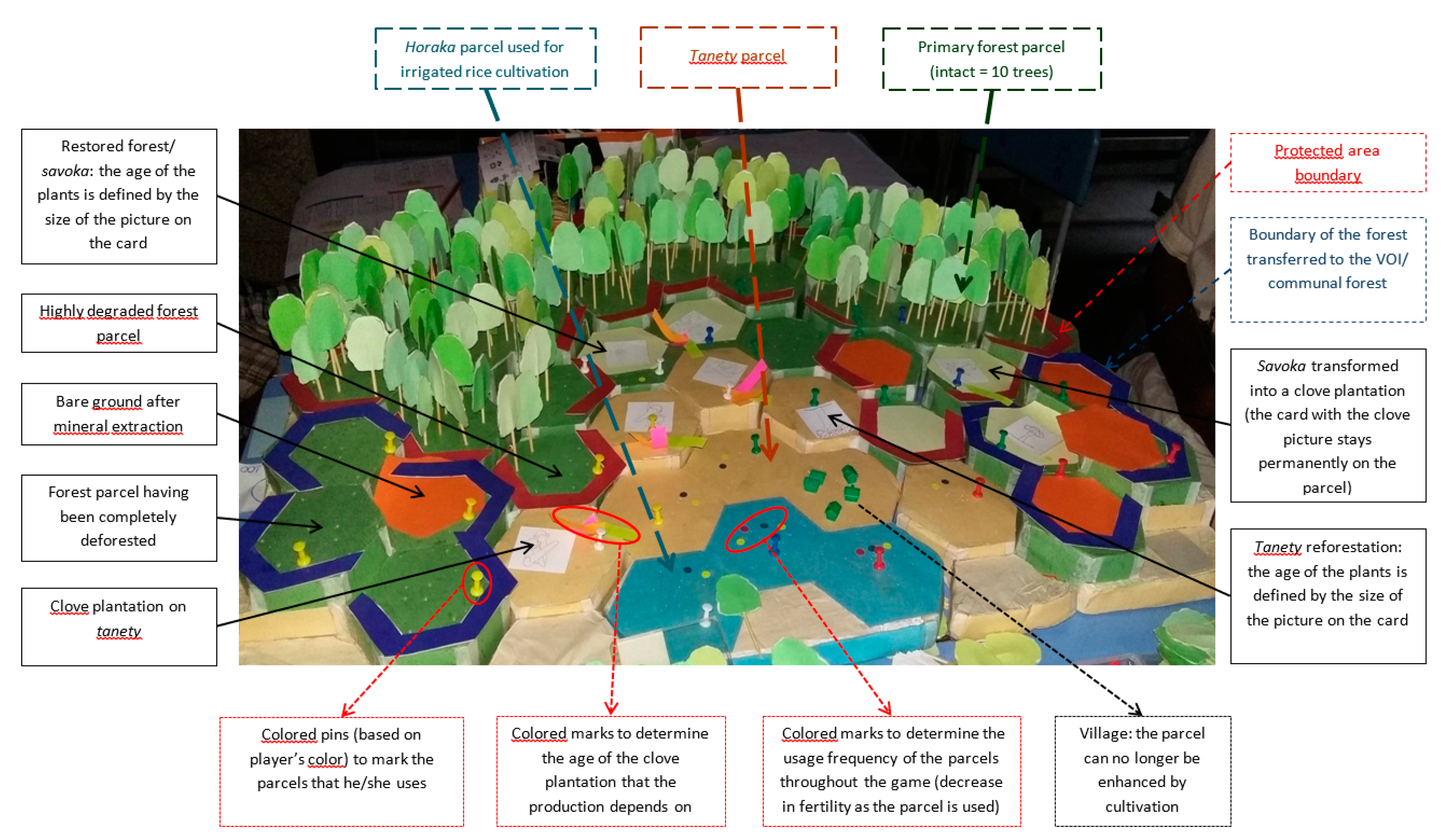
  • Firewood. Each round, players had to collect firewood in the form of stacks of wood in the forest plots. The number of stacks of wood to collect was equal to the number of people in a household. Players could still take more stacks of wood than necessary and keep the surplus for the next rounds. If a player failed to obtain the required number of stacks of wood, he had to cut a tree if the number of stacks of wood missing was less than five and two trees if the missing number was greater than five. However, if the player had a reforestation plot (aged from T2 = 10 years), it was assumed that he collected his firewood in his reforestation plot and no longer needed to cut trees in the forest.
  • Living costs. When a player did not have enough money to pay the obligatory costs of living at the end of a turn, he had to cut down a number of trees proportional to the amount he had to pay (one tree = 250). Each forest cell carried 10 trees and two piles of wood (corresponding to dead branches collected for firewood). The piles of wood were renewed at each turn in the following way: if the number of trees in the parcel was greater than five then there would still be two piles of wood; if the number of trees was less than five, there would be one pile of wood; if there were no trees on the plot, there would be no pile of wood.
Clearing cards. When there was a crop for the first time on a forest plot, it was assumed that there was clearing and burning. Since the behavior of the fire was unpredictable due to factors such as wind, burning method, etc., cards were drawn to find out what happened. In total, there were 10 cards in three categories: (i) two cards: no fire spread to neighboring plots; (ii) four cards: spreading of fire in four different directions; (iii) four cards: obligation to make a firewall. If the player made a firewall before the card was drawn, then the card was cancelled. If there was not yet a firewall, the player was obliged to pay a fine defined by the other players.
Forestry Administration. At the beginning of Scenario 1, we explained to the players that all the activities related to forests were the responsibility of the forest administration and that if they had any questions, they had to ask the manager, who stayed far from the play area (e.g., a neighboring room). The decision to go see the quartermaster was entirely up to the players. The time allowed for discussion with the quartermaster went hand in hand with the time to buy the activities at the market. The authorizations given by the quartermaster were only valid for one round and had to be renewed if necessary. At the end of round 2, the quartermaster made an appearance to raise awareness among the players. During round 3, he made another appearance and sanctioned players who did an activity in the forest during the round without authorization. The players had to go to the head quartermaster’s office to pay the fines. This was to see if the players had the initiative to pay the fines. The quartermaster did not make any appearances during scenario 2.
A debriefing followed the first scenario, allowing the discussion of gaming behavior and strategies, to bridge game characteristics and reality, and to exchange on underlying mechanisms and relationships.
At the onset of scenario 2, the facilitator explained the observable changes on the game board to the players and elaborated on the forest management rules that followed. Players were invited to consult each other; one of them was chosen as a volunteer for the CLP (Local Committee of the Park); he or she oversaw the surveillance and the protection of the protected area. Another player was elected as VOI president. Rules for the use of the VOI forest/community forest were discussed amongst the players. The CLP was provided with monitoring sheets for infractions in the protected area, which he completed each turn. Sanctions against activities in the protected area depended on the report made by the CLP. Once all the roles were assigned, the game session with scenario 2 started and the sequence was the same as for scenario 1.
Table A4. Statistical Analysis of Players’ Gaming Behavior and Land-Type Changes. Statistically significant differences between (i) Scenario 1 and 2 for very degraded forest; and (ii) between workshops 1–3 vs. 4–6 for the remaining variables. A Welch two-sample t-test was used with the R software version 3.0.3.
Variabletdfp95% Confidence IntervalsSample Estimates
Mean of xMean of y
Very degraded forest (S1–S2)2.103851.7640.040280.017911480.759866300.63888890.2500000
Livelihood4.3275202.232.37 × 10−56507.80717402.06017975.6676020.733
Moderately degraded forest2.229762.9280.029340.057636221.053474891.22222220.6666667
Very degraded forest2.103851.7640.040280.017911480.759866300.63888890.2500000
Completely deforested plots−2.307347.3610.02545−1.14383016−0.078392060.30555560.9166667
Table A5. Statistical Analysis of Players’ Gaming Behavior and Land-Type Changes. All game variables that showed a statistically significant difference between Scenario 1 and 2 are listed below. A non-parametric Wilcoxon rank sum test with continuity correction was used with the R software version 3.0.3.
VariableWpMore in
Clove in tanety (number)10,176.50.02893Scenario 1
Reforestation in tanety (number)11,9300.02396Scenario 1
Maize/bean in forest (number)12,530.50.0145Scenario 1
Activities in forest (total number)13,6310.0008079Scenario 1
Loss of forest to maize/bean12,223.50.002153Scenario 1
Active loss13,1090.004556Scenario 1
Table A6. Statistical Analysis of Players’ Gaming Behavior and Land-Type Changes. All game variables that showed a statistically significant difference between workshops 1–3 vs. 4–6 are listed below. A non-parametric Wilcoxon rank sum test with continuity correction was used with the R software version 3.0.3.
VariableWpMore in
Charcoal in forest (nb)12,0000.01529W1–3
Forest exploitation (nb)13,2756.608 × 10−7W1–3
Restoration exploitation (nb)10,8000.01361W4–6
Fertilizer, big (nb)7651.53.422 × 10−8W4–6
Fertilizer, small (nb)7622.51.194 × 10−7W4–6
Reforestation in forest (nb)10,5790.03441W4–6
Maize/bean in tanety (nb)81708.176 × 10−7W4–6
Mines (nb)12,6756.965 × 10−6W1–3
Tobacco/cassava in forest (nb)98410.0007592W4–6
Tobacco/cassava in tanety (nb)96150.0003511W4–6
Firebreak (nb)96600.004117W4–6
Rice in forest (nb)12,0750.006133W1–3
Activities (nb)81994.127 × 10−5W4–6
Loss for livelihood (nb)80922 × 10−8W4–6
Forced loss (nb)78621.465 × 10−7W4–6
Production (nb)13,7960.0007046W1–3
Reforestation tanety (nb)10,4340.006736W4–6
Maize/bean in forest (nb)12,6010.009898W1–3
Activities in forest (nb)14,4845.352 × 10−6W1–3
Active loss (nb)14,6023.137 × 10−7W1–3
Table A7. LandSat Accuracy Classification. Confusion Matrix Produced for Classification of August 2014 Landsat Data using Independent Validation Data.
123456TotalUsers (%)Commission (%)
Dense forest (1)4530000451000
Sparse/degraded forest (2)0450000451000
Grass/shrub-dominant (3)00360013797.32.7
Soil-dominant (4)0003600361000
Water (5)0000360361000
Vegetation swamp; wet agriculture (6)0000035351000
Total454536363636234
Producers (%)10010010010010097
Amission (%)000003
Overall99.6
Kappa0.99

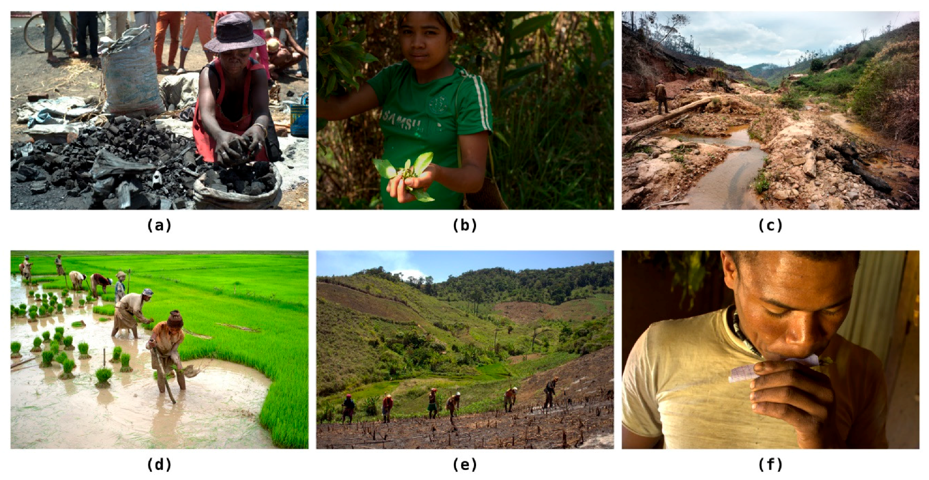
Appendix A.3. Perceptions on Livelihoods and Change in the Zahamena Socio-Ecological System (Statements of Miners in Interviews, and Farmers in Game Workshops)

“Quarries and mines are not the same as they used to be—there are many more today. It is a good thing, as its consequences for myself are that I can buy more things as my standard of living increases.” (I3, Vohimarina)
“Today Zahamena has also become an exploited area—there are many crystals and rubies there, with high prices. It is a bad thing because the protected area is getting destroyed and this leads to decreasing rain and volumes of water.” (I6, Vohimarina)
“It (mining) leads to forest destruction and decreasing numbers of animals, as they have to cut down forests to exploit the mines. It has also led to an increasing number of bandits.” (I18, Antanandava)
The Alaotra region is the rice granary of Madagascar. This crop is the staple food in Madagascar, and Malagasy tend to eat rice three times a day if they can afford it (cf. Figure 7).
“Rice farming is fundamental and it must be done because rice is irreplaceable.” (W6P3)
“Even if one has a lot of money but not enough rice, then all the money will be spent on buying rice for consumption.” (W6P5)
Slash-and-burn agriculture, or tavy, is the typical feature of the Zahamena socio-ecological system. This land clearing and transformation into crops is slowly eating the national park (Figure 6), home to 13 different species of lemurs [88].
“As we do not own irrigated rice paddies, we maintain our livelihood with tavy.” (Focus group participant FG2, Ambongabe)
“(We continue to practice tavy because) arable land, especially the horaka (irrigable rice fields) are insufficient, so one has to do it in the face of demographic growth.” (W1P3)
“The population is experiencing strong demographic growth, livelihoods are becoming more and more difficult, land is no longer enough, so this means that people are progressively using the edges of the forests.” (W4P5)

Appendix A.4. Perceptions of Farmers on the Best-Suited Forest Management System (Statements of Game Workshop Debriefings)

The consensus amongst the game workshop participants is that local management would still be best suited to serve the local population, who has livelihood security as the highest priority.
“Management by the VOI (out of the three governance systems is best suited) because the forest has already been given to the community; if it is exhausted, then we have to move to other types of forest.” (W4P1)
“The VOI system because there we are less afraid. (W4P2)
“It is better to let the local population manage the forests; this way, we have enough arable land and there are no more constraints because of administrative procedures; we no longer need to move far to the chef de cantonnement, it is enough to set up a dina to handle the cutting of large-diameter wood. Prioritizing land availability over the long term is more important than protecting the forest.” (W4P5)
“The actions must be prioritized to improve the standard of living and the livelihoods of local populations if we want to protect the forest.” (W6P5)
Still, other participants would prefer a protected area system and/or state control over the forests to ensure their protection.
“The protected area because it is more difficult to discuss and confront the managers. If a person is designated (among the villagers), decisions are generally not respected.” (W1P1)
“In addition (to VOI), the central management should take over the work of the chef de cantonnement; respect and correctly apply the regulations without distinction or exception.” (W1P4)
“The protected area because the managers show no mercy and they do not hesitate to call on gendarme.” (W2P2)

Appendix A.5. Authority Perceptions of Forest Governance Issues in the Alaotra Mangoro Region

Statements or information stemming from local forest governance authorities are listed first, followed by statements from regional, more distant offices.
“VOIs are not able to play their role in forest management for various reasons: dina (local laws and rules) are not respected. Forest patrols are irregular for lack of compensation; declarations of violations to forest regulations are not reported for fear of being threatened and rejected by the community whose majority are not members of VOI. Members who have registered are either not active and/or do not pay their annual dues. Slash-and-burn agriculture and logging are common practices in VOI-managed forests as controls in the Zahamena Protected Area are more strict.” (VOI Presidents, Antanandava)
“(The problem is the) lack of staff and means of the agents to ensure the forest controls especially in the few remaining state forests. In cases where the forest agents notice an infraction in the forest areas, they can appeal to the authorities like the gendarmerie, but that requires financial means.” (Staff member of the cantonnement forestier, Vavatenina)
“Much of Zahamena National Park is part of the Ambatondrazaka district, while MNP staff in this sector is understaffed. (…) The practice of tavy is a traditional mode of cultivation where peasants move to clear one plot after another; forests managed by VOI juxtaposed with the protected area are the most affected by this practice, despite the measures taken, such as the use of firewalls and forest patrols, fires arrive right into the protected area.” (MNP, Antanandava)
“The advantages of VOI are that those managing the resources live in proximity to them. Members are volunteers, and therefore, protective and motivated (sic). It is a way to give rights to communities and allow them to manage the resources on which they depend. The royalties from this management (ecotourism, value added from natural resources) allow the communities to finance this management. (…) The issues with VOI are that the members are farmers and fishers, so often poor and uneducated. Local rules are not always compatible with regional legislations. (…) A big issue is the monitoring of each VOI, as there are 200 of them in the Alaotra region, and the Ministry does not have the funds and staff to do this. There are certain NGOs that help with this task. Many VOIs need to be revitalized, but here again there are financial issues. Since the crisis (January 2009), no new VOI contracts have been signed.” (Ministry of the Environment, Ecology, Seas, and Forests, Ambatondrazaka)
“The Ministers are constantly changing, and there is no time of stability, so no long-term vision can take place. Thinking one or two years in the future is not done. Work is always in the short-term.” (Ministry of Fisheries, Ambatondrazaka)
“Before, 2000, the Forest Administration distributed tavy to communities bordering the forests, but with the new policy no more permits are issued for this activity. The Forest Administration lacks personnel, materials, and equipment; the areas of intervention are far, so we cannot monitor the savoka, that is why we decided to no longer issue clearing permits.” (DREEF Alaotra-Mangoro, regional director, Ambatondrazaka)
According to the DREEF (Directeur Régional de l’Environnement, de l’Écologie, et des Forêts), problems with the transfer of forest management to VOIs are as follows: (i) the possibility of local conciliation cannot be ruled out; for example, if the written request is inferior to the actual demand, the quantity is distorted and the surplus of the right belongs to the management committee. (ii) There are still gaps where the sanctions are not well defined; there is no big difference between forests transferred or not. (iii) During the management transfer application process, the Forest Administration is only involved by the project promoters at the signature request stage so that many anomalies in the documents can be identified—resulting in the contract not being approved and having no continuation. In some cases, these requests are mainly for operational purposes, which is why the Administration must remain cautious with regard to requests for transfer of management. (iv) There is no close cooperation between the Forest Administration and the MNP; the Forest Administration is usually consulted only in case of force majeure.
“The problem with the management transfer around the Park (Zahamena) is that the consultants who worked on it did not involve the Forest Administration. Therefore, the status and especially the role of the VOI is only in name and the transfer of management is unsuccessful, and the contract is not signed or implemented. (…) It is for consideration of the subsistence of the population living in areas without irrigated rice fields that the state has given authorizations for the clearing of dense forests. This authorization has validity—it is as if the community borrowed the land from the state for a period and, after the harvest, these people have no rights over the land they used. However, people conceive that the land becomes their property once they have obtained an authorization. (…) The forest is a property belonging to the whole country, everyone must feel responsible for its protection.” (DREEF Alaotra-Mangoro, chef de cantonnement, Ambatondrazaka)

References

  1. Curtis, P.G.; Slay, C.M.; Harris, N.L.; Tyukavina, A.; Hansen, M.C. Classifying drivers of global forest loss. Science 2018, 361, 1108–1110. [Google Scholar] [CrossRef] [PubMed]
  2. Foley, J.A.; DeFries, R.; Asner, G.P.; Barford, C.; Bonan, G.; Carpenter, S.R.; Chapin, F.S.; Coe, M.T.; Daily, G.C.; Gibbs, H.K.; et al. Global consequences of land use. Science 2005, 309, 570–574. [Google Scholar] [CrossRef] [PubMed]
  3. Song, X.-P.; Hansen, M.C.; Stehman, S.V.; Potapov, P.V.; Tyukavina, A.; Vermote, E.F.; Townshend, J.R. Global land change from 1982 to 2016. Nature 2018, 560, 639–643. [Google Scholar] [CrossRef] [PubMed]
  4. Geist, H.J.; Lambin, E.F. Proximate causes and underlying driving forces of tropical deforestation: Tropical forests are disappearing as the result of many pressures, both local and regional, acting in various combinations in different geographical locations. BioScience 2002, 52, 143–150. [Google Scholar] [CrossRef]
  5. Moat, J.; Smith, P.P. Atlas of the Vegetation of Madagascar; Royal Botanic Gardens: London, UK, 2007. [Google Scholar]
  6. Buerki, S.; Devey, D.S.; Callmander, M.W.; Phillipson, P.B.; Forest, F. Spatio-temporal history of the endemic genera of Madagascar. Bot. J. Linn. Soc. 2013, 171, 304–329. [Google Scholar] [CrossRef] [Green Version]
  7. Ganzhorn, J.U.; Wilmé, L.; Mercier, J.L. Explaining Madagascar’s biodiversity. In Conservation and Environmental Management in Madagascar; Scales, I.R., Ed.; Routledge: London, UK, 2014; pp. 41–67. [Google Scholar]
  8. Waeber, P.O.; Wilmé, L.; Ramamonjisoa, B.; Garcia, C.; Rakotomalala, D.; Rabemananjara, Z.H.; Kull, C.A.; Ganzhorn, J.U.; Sorg, J.-P. Dry forests in Madagascar: Neglected and under pressure. Int. For. Rev. 2015, 17, 127–148. [Google Scholar] [CrossRef]
  9. Global Forest Watch. Tree Cover Loss and Gain Area. Available online: https://www.globalforestwatch.org/dashboards/country/MDG (accessed on 20 July 2018).
  10. Waeber, P.O.; Schuurman, D.; Wilmé, L. Madagascar’s rosewood (Dalbergia spp.) stocks as a political challenge. PeerJ Prepr. 2018, e27062v1. [Google Scholar] [CrossRef]
  11. Vieilledent, G.; Grinand, C.; Rakotomalala, F.A.; Ranaivosoa, R.; Rakotoarijaona, J.R.; Allnutt, T.F.; Achard, F. Combining global tree cover loss data with historical national forest cover maps to look at six decades of deforestation and forest fragmentation in Madagascar. Biol. Conserv. 2018, 222, 189–197. [Google Scholar] [CrossRef]
  12. Horning, N.R. Strong support for weak performance: Donor competition in Madagascar. Afr. Affairs 2008, 107, 405–431. [Google Scholar] [CrossRef]
  13. Waeber, P.O.; Wilmé, L.; Mercier, J.R.; Camara, C.; Lowry, P.P., II. How effective have thirty years of internationally driven conservation and development efforts been in Madagascar? PLoS ONE 2016, 11, e0161115. [Google Scholar] [CrossRef] [PubMed]
  14. Scales, I.R. Farming at the forest frontier: Land use and landscape change in western Madagascar, 1896–2005. Environ. Hist. 2011, 17, 499–524. [Google Scholar] [CrossRef]
  15. Scales, I.R. The drivers of deforestation and the complexity of land use in Madagascar. In Conservation and Environmental Management in Madagascar, 1st ed.; Scales, I.R., Ed.; Routledge: London, UK, 2014; pp. 129–150. [Google Scholar]
  16. Casse, T.; Milhøj, A.; Ranaivoson, S.; Randriamanarivo, J.R. Causes of deforestation in southwestern Madagascar: What do we know? For. Policy Econ. 2004, 6, 33–48. [Google Scholar] [CrossRef]
  17. Moser, C. An economic analysis of deforestation in Madagascar in the 1990s. Environ. Sci. 2008, 5, 91–108. [Google Scholar] [CrossRef]
  18. Humbert, H. La Destruction D’une Flore Insulaire Par Le Feu: Principaux Aspects De La Végétation À Madagascar; Mémoires De l’Académie Malgache 5; Imprimerie Moderne de l’Emyrne, G. Pitot et Cie.: Tananarive, Madagascar, 1927; pp. 1–80. [Google Scholar]
  19. Favre, J.C. Traditional utilization of the forest. In Ecology and Economy of a Tropical Dry Forest in Madagascar; Ganzhorn, J.U., Sorg, J.-P., Eds.; Primate Report 46-1: Göttingen, Germany, 1996; pp. 33–40. [Google Scholar]
  20. Laurent, J. The Programme Menabe in Madagascar: A project of the Cooperation Suisse. In Ecology and Economy of a Tropical Dry Forest in Madagascar; Ganzhorn, J.U., Sorg, J.-P., Eds.; Primate Report 46-1: Göttingen, Germany, 1996; pp. 5–12. [Google Scholar]
  21. Styger, E.; Rakotondramasy, H.M.; Pfeffer, M.J.; Fernandes, E.C.; Bates, D.M. Influence of slash-and-burn farming practices on fallow succession and land degradation in the rainforest region of Madagascar. Agric. Ecosyst. Environ. 2007, 119, 257–269. [Google Scholar] [CrossRef]
  22. Poudyal, M.; Jones, J.P.G.; Rakotonarivo, O.S.; Hockley, N.; Gibbons, J.M.; Mandimbiniaina, R.; Rasoamanana, A.; Andrianantenaina, N.S.; Ramamonjisoa, B.S. Who bears the cost of forest conservation? PeerJ 2018, 6, E5106. [Google Scholar] [CrossRef] [PubMed]
  23. Pollini, J. Agroforestry and the search for alternatives to slash-and-burn cultivation: From technological optimism to a political economy of deforestation. Agric. Ecosyst. Environ. 2009, 133, 48–60. [Google Scholar] [CrossRef]
  24. Urech, Z.L.; Felber, H.R.; Sorg, J.P. Who wants to conserve remaining forest fragments in the Manompana Corridor? Madag. Conserv. Dev. 2012, 7, 135–143. [Google Scholar] [CrossRef]
  25. Urech, Z.L.; Zaehringer, J.G.; Rickenbach, O.; Sorg, J.-P.; Felber, H.R. Understanding deforestation and forest fragmentation from a livelihood perspective. Madag. Conserv. Dev. 2015, 10, 67–76. [Google Scholar] [CrossRef] [Green Version]
  26. Dressler, W.; Büscher, B.; Schoon, M.; Brockington, D.; Hayes, T.; Kull, C.; McCarthy, J.; Shrestha, K. From hope to crisis and back again? A critical history of the global CBNRM narrative. Environ. Conserv. 2010, 37, 5–15. [Google Scholar] [CrossRef] [Green Version]
  27. Measham, T.G.; Lumbasi, J.A. Success factors for community-based natural resource management (CBNRM): Lessons from Kenya and Australia. Environ. Manag. 2013, 52, 649–659. [Google Scholar] [CrossRef] [PubMed]
  28. Pollini, J.; Lassoie, J.P. Trapping farmer communities within global environmental regimes: The case of the GELOSE legislation in Madagascar. Soc. Nat. Resour. 2011, 24, 814–830. [Google Scholar] [CrossRef]
  29. Mercier, J.R. The preparation of the National Environmental Action Plan (NEAP): Was it a false start? Madag. Conserv. Dev. 2006, 1, 50–54. [Google Scholar] [CrossRef]
  30. Raik, D. Forest management in Madagascar: An historical overview. Madag. Conserv. Dev. 2007, 2, 5–10. [Google Scholar] [CrossRef]
  31. Borrini-Feyerabend, G.; Dudley, N. Élan Durban: Nouvelles perspectives pour les Aires Protégées de Madagascar 2005. Available online: http://www.equilibriumresearch.com/upload/document/elandurban.pdf (accessed on 20 July 2018).
  32. Kull, C.A. Empowering pyromaniacs in Madagascar: Ideology and legitimacy in community-based natural resource management. Dev. Change 2002, 33, 57–78. [Google Scholar] [CrossRef]
  33. Antona, M.; Motte Biénabe, E.; Salles, J.-M.; Péchard, G.; Aubert, S.; Ratsimbarison, R. Rights transfers in Madagascar biodiversity policies: Achievements and significance. Environ. Dev. Econ. 2004, 9, 825–847. [Google Scholar] [CrossRef]
  34. Raik, D.B.; Decker, D.J. A multisector framework for assessing community-based forest management: Lessons from Madagascar. Ecol. Soc. 2007, 12, 1. Available online: http://www.ecologyandsociety.org/vol12/iss1/art14/ (accessed on 20 July 2018). [CrossRef]
  35. Fritz-Vietta, N.V.; Röttger, C.; Stoll-Kleemann, S. Community-based management in two biosphere reserves in Madagascar–distinctions and similarities: What can be learned from different approaches? Madag. Conserv. Dev. 2009, 4, 86–97. [Google Scholar] [CrossRef]
  36. Horning, N.R. Across the great divide: Collaborative forest management. In The Politics of Deforestation in Africa: Madagascar, Tanzania, and Uganda, 1st ed.; Horning, N.R., Ed.; Palgrave Mcmillan: Basingstoke, UK, 2018; pp. 135–163. ISBN 978-3-319-76827-4. [Google Scholar]
  37. Neudert, R.; Ganzhorn, J.U.; Wätzold, F. Global benefits and local costs—The dilemma of tropical forest conservation: A review of the situation in Madagascar. Environ. Conserv. 2017, 44, 82–96. [Google Scholar] [CrossRef]
  38. Gardner, C.J.; Nicoll, M.E.; Birkinshaw, C.; Harris, A.; Lewis, R.E.; Rakotomalala, D.; Ratsifandrihamanana, A.N. The rapid expansion of Madagascar’s protected area system. Biol. Conserv. 2018, 220, 29–36. [Google Scholar] [CrossRef]
  39. Rasolofoson, R.A.; Ferraro, P.J.; Jenkins, C.N.; Jones, J.P. Effectiveness of community forest management at reducing deforestation in Madagascar. Biol. Conserv. 2015, 184, 271–277. [Google Scholar] [CrossRef]
  40. Rasolofoson, R.A.; Ferraro, P.J.; Ruta, G.; Rasamoelina, M.S.; Randriankolona, P.L.; Larsen, H.O.; Jones, J.P. Impacts of community forest management on human economic well-being across Madagascar. Conserv. Lett. 2017, 10, 346–353. [Google Scholar] [CrossRef]
  41. Visser, L.E. Reflections on transdisciplinarity, integrated coastal development, and governance. In Challenging Coasts: Transdisciplinary Excursions into Integrated Coastal Zone Development; Visser, L.E., Ed.; Amsterdam University Press: Amsterdam, The Netherlands, 2004; pp. 23–47. [Google Scholar]
  42. Béné, C.; Wood, R.G.; Newsham, A.; Davies, M. Resilience: New utopia or new tyranny? Reflection about the potentials and limits of the concept of resilience in relation to vulnerability reduction programmes. IDS Working Pap. 2012, 405, 1–61. Available online: https://www.ids.ac.uk/publication/resilience-new-utopia-or-new-tyranny (accessed on 20 July 2018). [CrossRef]
  43. Sanderson, I. Evaluation, policy learning and evidence-based policy making. Public Admin. 2002, 80, 1–22. [Google Scholar] [CrossRef]
  44. Lavis, J.N.; Robertson, D.; Woodside, J.M.; McLeod, C.B.; Abelson, J. How can research organizations more effectively transfer research knowledge to decision makers? Milbank Q. 2003, 81, 221–248. [Google Scholar] [CrossRef] [PubMed]
  45. Gautier, D.; Garcia, C.; Negi, S.; Wardell, D.A. The limits and failures of existing forest governance standards in semi-arid contexts. Int. For. Rev. 2015, 17, 114–126. [Google Scholar] [CrossRef]
  46. Gardner, C.J. Social learning and the researcher–practitioner divide. Oryx 2012, 46, 313–314. [Google Scholar] [CrossRef] [Green Version]
  47. Sayer, J.; Bull, G.; Elliott, C. Mediating forest transitions: ‘Grand design ‘or’ muddling through’. Conserv. Soc. 2008, 6, 320–327. [Google Scholar] [CrossRef]
  48. Rives, F.; Carrière, S.M.; Montagne, P.; Aubert, S.; Sibelet, N. Forest management devolution: Gap between technicians’ design and villagers’ practices in Madagascar. Environ. Manag. 2013, 52, 877–893. [Google Scholar] [CrossRef] [PubMed]
  49. Rittel, H.W.; Webber, M.M. Dilemmas in a general theory of planning. Policy Sci. 1973, 4, 155–169. [Google Scholar] [CrossRef]
  50. Etienne, M. Companion Modelling, a Participatory Approach to Support Sustainable Development, 1st ed.; Springer: Dordrecht, The Netherlands, 2014; ISBN 978-94-017-8556-3. [Google Scholar]
  51. Waeber, P.O.; De Grave, A.; Wilmé, L.; Garcia, C. Play, learn, explore: Grasping complexity through gaming and photography. Madag. Conserv. Dev. 2017, 12. [Google Scholar] [CrossRef]
  52. Rakotoarisoa, T.F.; Waeber, P.O.; Richter, T.; Mantilla-Contreras, J. Water hyacinth (Eichhornia crassipes), any opportunities for the Alaotra wetlands and livelihoods? Madag. Conserv. Dev. 2015, 10, 128–136. [Google Scholar] [CrossRef]
  53. Bousquet, F.; Trébuil, G.; Hardy, B. Companion Modeling and Multi-Agent Systems for Integrated Natural Resource Management in Asia; International Rice Research Institute: Los Baños, Philippines, 2005. [Google Scholar]
  54. Dumrongrojwatthana, P.; Barnaud, C.; Gajaseni, N.; Trébuil, G. Companion modeling to facilitate adaptive forest management in Nam Haen sub-watershed, Nan Province, Northern Thailand. In Proceedings of the Towards Sustainable Livelihood and Environment: 2nd International Conference Asian Simulation and Modelling (ASIMMOD 2007), Chiang Mai, Thailand, 9–11 January 2007; pp. 327–332. Available online: http://agritrop.cirad.fr/543099/ (accessed on 20 July 2018).
  55. Dumrongrojwatthana, P.; Trébuil, G. Northern Thailand Case: Gaming and Simulation for Co-Learning and Collective Action; Companion Modelling for Collaborative Landscape Management between Herders and Foresters; Wageningen Academic Publishers: Wageningen, The Netherlands, 2011; pp. 191–219. [Google Scholar]
  56. Garcia, C.; Speelman, E.N. Landscape approaches, wicked problems and role playing games. Tropenbos International ComMod Workshop. ForDev Working Pap. 2015, 1, 1–20. Available online: http://www.researchgate.net/publication/320170969 (accessed on 20 July 2018).
  57. Speelman, E.N.; van Noordwijk, M.; Garcia, C. Gaming to better manage complex natural resource landscapes. In Co-Investment in Ecosystem Services: Global Lessons from Payment and Incentive Schemes; Namirembe, S., Leimona, B., van Noordwijk, M., Minang, P.A., Eds.; World Agroforestry Centre (ICRAF): Nairobi, Kenya, 2017. [Google Scholar]
  58. Etienne, M.; Du Toit, D.R.; Pollard, S. ARDI: A co-construction method for participatory modelling in natural resources management. Ecol. Soc. 2011, 16, 44. Available online: http://www.ecologyandsociety.org/vol16/iss1/art44/ (accessed on 20 July 2018). [CrossRef]
  59. USGS. Available online: https://landsat.usgs.gov/landsat-surface-reflectance-data-products (accessed on 25 July 2018).
  60. Banskota, A.; Kayastha, N.; Falkowski, M.J.; Wulder, M.A.; Froese, R.E.; White, J.C. Forest monitoring using Landsat time series data: A review. Can. J. Remote Sens. 2014, 40, 362–384. [Google Scholar] [CrossRef]
  61. World Bank. Critical Ecosystem Partnership Fund; Global program review 2, 1; Washington, DC, USA, 2007; Available online: http://documents.worldbank.org/curated/en/865411468153290094/Critical-Ecosystem-Partnership-Fund-CEPF (accessed on 20 July 2018).
  62. Erbek, F.S.; Özkan, C.; Taberner, M. Comparison of maximum likelihood classification method with supervised artificial neural network algorithms for land use activities. Int. J. Remote Sens. 2004, 25, 1733–1748. [Google Scholar] [CrossRef]
  63. Jensen, L.S.; Mueller, T.; Tate, K.R.; Ross, D.J.; Magid, J.; Nielsen, N.E. Soil surface CO2 flux as an index of soil respiration in situ: A comparison of two chamber methods. Soil Biol. Biochem. 1996, 28, 1297–1306. [Google Scholar] [CrossRef]
  64. R Core Team. R: A Language and Environment for Statistical Computing; R Foundation for Statistical Computing: Vienna, Austria, 2013; Available online: http://www.R-project.org/ (accessed on 20 July 2018).
  65. Turner, I.M. Species loss in fragments of tropical rain forest: A review of the evidence. J. Appl. Ecol. 1996, 33, 200–209. [Google Scholar] [CrossRef]
  66. Rappaport, D.I.; Morton, D.C.; Longo, M.; Keller, M.; Dubayah, R.; dos-Santos, M.N. Quantifying long-term changes in carbon stocks and forest structure from Amazon forest degradation. Environ. Res. Lett. 2018, 13, 065013. [Google Scholar] [CrossRef]
  67. Reibelt, L.M.; Woolaver, L.; Moser, G.; Randriamalala, I.H.; Raveloarimalala, L.M.; Ralainasolo, F.B.; Ratsimbazafy, J.; Waeber, P.O. Contact matters: Local people’s perceptions of Hapalemur alaotrensis and implications for conservation. Int. J. Primatol. 2017, 38, 588–608. [Google Scholar] [CrossRef]
  68. Timko, J.A.; Waeber, P.O.; Kozak, R.A. The socio-economic contribution of non-timber forest products to rural livelihoods in Sub-Saharan Africa: Knowledge gaps and new directions. Int. For. Rev. 2010, 12, 284–294. [Google Scholar] [CrossRef]
  69. Ameyaw, J.; Arts, B.; Wals, A. Challenges to responsible forest governance in Ghana and its implications for professional education. For. Policy Econ. 2014, 62, 78–87. [Google Scholar] [CrossRef]
  70. Sundström, A. Understanding illegality and corruption in forest governance. J. Environ. Manag. 2016, 181, 779–790. [Google Scholar] [CrossRef] [PubMed]
  71. Pascual, U.; Phelps, J.; Garmendia, E.; Brown, K.; Corbera, E.; Martin, A.; Gomez-Baggethun, E.; Muradian, R. Social equity matters in payments for ecosystem services. BioScience 2014, 64, 1027–1036. [Google Scholar] [CrossRef]
  72. Waeber, P.O.; Reibelt, L.M.; Randriamalala, I.H.; Moser, G.; Raveloarimalala, L.M.; Ralainasolo, F.B.; Ratsimbazafy, J.; Woolaver, L. Local awareness and perceptions: Consequences for conservation of marsh habitat at Lake Alaotra for one of the world’s rarest lemurs. Oryx 2017, 1–10. [Google Scholar] [CrossRef]
  73. Kairu, A.; Upton, C.; Huxham, M.; Kotut, K.; Mbeche, R.; Kairo, J. From shiny shoes to muddy reality: Understanding how meso-state actors negotiate the implementation gap in participatory forest management. Soc. Nat. Resour. 2017, 31, 74–88. [Google Scholar] [CrossRef]
  74. Berkes, F. Rethinking community-based conservation. Conserv. Biol. 2004, 18, 621–630. [Google Scholar] [CrossRef]
  75. Rendigs, A.; Reibelt, L.M.; Ralainasolo, F.B.; Ratsimbazafy, J.H.; Waeber, P.O. Ten years into the marshes–Hapalemur alaotrensis conservation, one step forward and two steps back? Madag. Conserv. Dev. 2015, 10, 13–20. [Google Scholar] [CrossRef]
  76. Levins, R. The strategy of model building in population biology. Am. Sci. 1966, 54, 421–431. [Google Scholar]
  77. Garcia, C.; Dray, A.; Waeber, P. Learning begins when the game is over: Using games to embrace complexity in natural resources management. GAIA-Ecol. Pers. Sci. Soc. 2016, 25, 289–291. [Google Scholar] [CrossRef]
  78. Reibelt, L.M.; Moser, G.; Dray, A.; Randriamalala, I.H.; Chamagne, J.; Ramamonjisoa, B.; Garcia Barrios, L.; Garcia, C.; Waeber, P.O. Tool development to understand rural resource users’ land use and impacts on land type changes in Madagascar. Madag. Conserv. Dev. 2017. [Google Scholar] [CrossRef]
  79. Stoudmann, N.; Waeber, P.O.; Randriamalala, I.H.; Garcia, C. Perception of change: Narratives and strategies of farmers in Madagascar. J. Rural Stud. 2017, 56, 76–86. [Google Scholar] [CrossRef]
  80. Maret, F. Madagascar. In Distortions to Agricultural Incentives in Africa; Anderson, K., Masters, W.A., Eds.; World Bank: Washington, DC, USA, 2009; pp. 101–125. [Google Scholar]
  81. Reibelt, L.M.; Nowack, J. Community-based conservation in Madagascar, the ‘cure-all’ solution? Madag. Conserv. Dev. 2015, 10, 3–5. [Google Scholar] [CrossRef]
  82. Fowler, R.; Rockstrom, J. Conservation tillage for sustainable agriculture: An agrarian revolution gathers momentum in Africa. Soil Till. Res. 2001, 61, 93–108. [Google Scholar] [CrossRef]
  83. Denich, M.; Vlek, P.L.; de Abreu Sá, T.D.; Vielhauer, K.; Lücke, W. A concept for the development of fire-free fallow management in the Eastern Amazon, Brazil. Agric. Ecosyst. Environ. 2005, 110, 43–58. [Google Scholar] [CrossRef]
  84. Tittonell, P.; Giller, K.E. When yield gaps are poverty traps: The paradigm of ecological intensification in African smallholder agriculture. Field Crops Res. 2013, 143, 76–90. [Google Scholar] [CrossRef]
  85. Wilmé, L.; Waeber, P.O.; Moutou, F.; Gardner, C.J.; Razafindratsima, O.; Sparks, J.; Kull, C.A.; Ferguson, B.; Lourenco, W.R.; Jenkins, P.D. A proposal for ethical research conduct in Madagascar. Madag. Conserv. Dev. 2016, 11. [Google Scholar] [CrossRef] [Green Version]
  86. Ravaka, A.; Ramamonjisoa, B.S.; Ratsimba, H.R.; Ratovoson, A.N.A. Circuit court du marché des produits agricoles: Pour une gestion efficace du paysage ouvert, cas du bassin-versant de Maningory, Madagascar. Madag. Conserv. Dev. 2017, 12. [Google Scholar] [CrossRef]
  87. Stoudmann, N.; Garcia, C.; Randriamalala, I.H.; Rakotomalala, V.A.G.; Ramamonjisoa, B. Two sides to every coin: Farmers’ perceptions of mining in the Maningory watershed, Madagascar. Madag. Conserv. Dev. 2016, 11, 91–95. [Google Scholar] [CrossRef]
  88. Gardner, C.J.; Waeber, P.O.; Razafindratsima, O.H.; Wilmé, L. Decision complacency and conservation planning. Conserv. Biol. 2018. [Google Scholar] [CrossRef] [PubMed]
Figure 1. Study area within the Maningory watershed, with locations of the six game workshops (W1–6). Humid dense forest (black), degraded forest (dark grey), agricultural matrix (grey), and grasslands, including wooded grasslands (light grey), other land types such as water bodies, wetlands, and irrigated rice fields (white). Contours in red show National Park boundaries of Zahamena, and grey delimits Lake Alaotra, where other interviews to this research were conducted. The white north–south dividing line is the political boundary between the two districts, Analanjirofo in the east and Alaotra-Mangoro in the west. Land types are based on Landsat imagery classification using Labord projection (LC8158072_0722014236; LC8158073_0732014236; LC8159072_0722014259 Courtesy of the United States (US) Geological Survey).
Forests 09 00624 g001
Figure 2. Conceptual model of the Zahamena socio-ecological system showing the interactions of actors and resources. Actors represent either individuals (light blue) or institutions (dark blue); resources are either primary (square boxes) or commodities (ellipsoids). The verbs on the arrows describe the main interactions between two entities.
Forests 09 00624 g002
Figure 3. Conceptual model of land-use change and (post-) cultural dynamics in the Zahamena socio-ecological system. Natural succession (left panel) is compared with agricultural practices (yellow box); processes: tavy and/or cutting (red arrows), cultivating (green arrows), and resting periods/fallows (blue arrows). Local Betsimisaraka terms are in italics.
Forests 09 00624 g003
Figure 4. Game landscape (gamescape) change over the course of 25 years, comparing scenario 1 (left) vs. scenario 2 (right); W1–6 represent the six game workshops. Over the period of five rounds—five years per round (R)—land types change according to players’ decisions and activities. Original landscape for both scenarios (top) is composed of 35 dense forest cells (dark green), eight tanety cells (brown), and three irrigated rice field cells (blue). Scenario 2 has, in addition, a National Park (red contours), and community-based forests (blue contours). The other greens (darker to bright) represent forest degradation (low to high), red represents a completely deforested cell; yellow represents a fallow (savoka), green hashed represents reforestation, and brown hashed represents a clove plantation. Details of the actual role-playing game (RPG) are provided in Figure A2.
Forests 09 00624 g004
Figure 5. Deforestation and degradation happening in the gamescape. Scenario comparison for the number of plots with dense forest (a) and the area of degraded forest (c); interactive effects between scenario and workshop for dense forest (boxplots, (b)) and for degraded forest (d).
Forests 09 00624 g005
Figure 6. Supervised maximum-likelihood classification results of Landsat imagery showing the distribution of targeted land-cover classes in the study area for June 1990 (Panel A) and August 2014 (Panel B). Panel C shows loss, persistence, and gain in dense forest from 1990–2014 in and around the Zahamena National Park. The background image is the near-infrared (NIR) band of Landsat imagery from August 2014. The boundary for the Zahamena National Park appears in yellow in all panels. The coordinates for all panels are Universal Transverse Mercator (UTM) Zone 39 South.
Forests 09 00624 g006
Figure 7. Characteristic land use in the Zahamena socio-ecological system. The ethno-photography in environmental science method (cf. Reference [58]) allows for a shared vision of the landscape uses and proposes a visual characterization of user-defined important livelihood activities surrounding the remaining dense forests: charcoal (a), clove cultivation (b), artisanal small-scale mining (c), rice in flooded paddies (d), tavy (e), and tobacco (f).
Forests 09 00624 g007

