
A High-Resolution Map of Emerald Ash Borer Invasion Risk for Southern Central Europe

Abstract
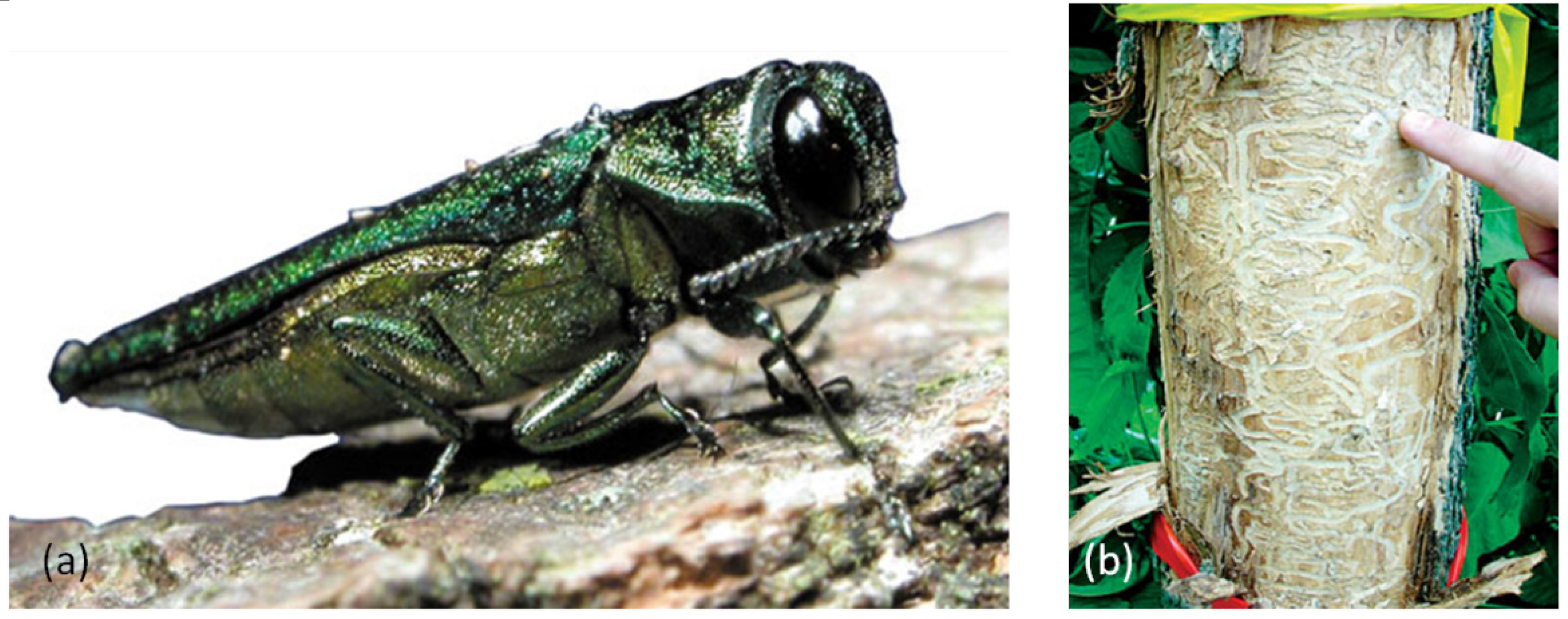
:1. Introduction

2. Material and Methods
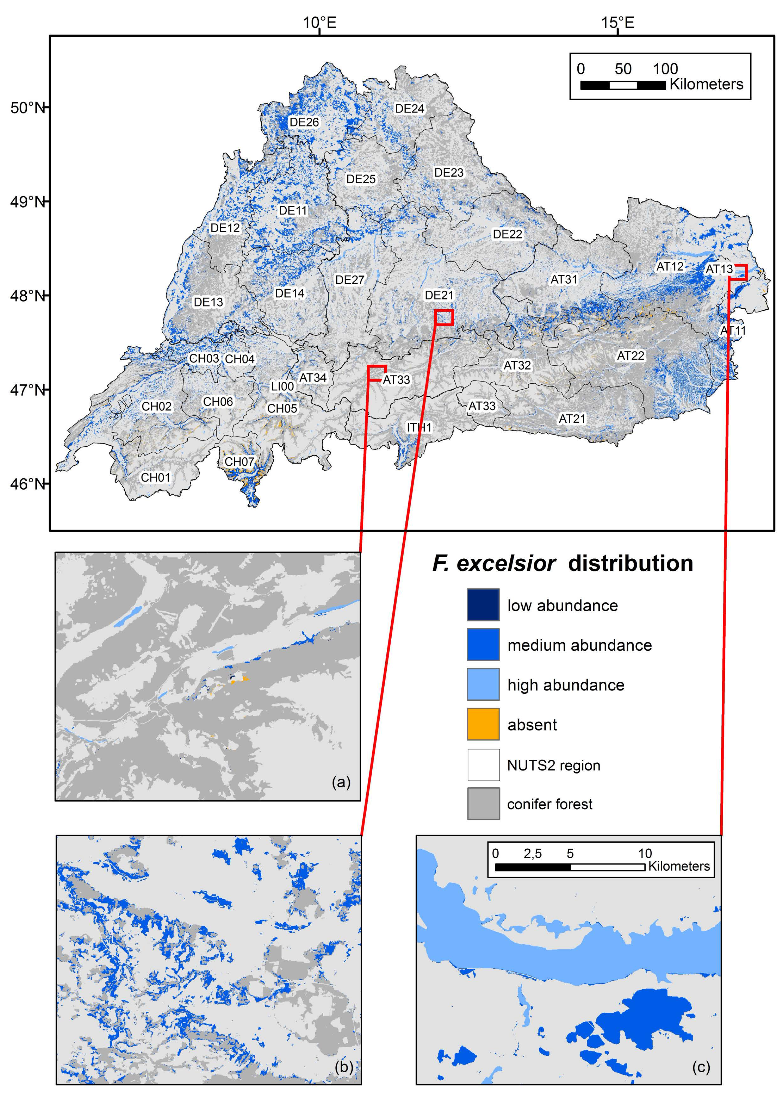
2.1. Forest Distribution Map

2.2. Regionalizing Common Ash Distribution and Abundance

| Criteria | Austria | Germany (BW/BAV) | Switzerland | South Tyrol | References |
|---|---|---|---|---|---|
| Proportion of Fraxinus excelsior in forests | 2.7% | 4.9%/1.1% | 3.4% | <2% | [19,20,21,22], Buechsenmeister pers. comm. |
| Altitudinal distribution | <900: ~6% | <900: ~6% | <900: ~6% | <900: ~6% | [15] |
| 900–1200: ~2% | 900–1200: ~2% | 900–1200: ~2% | 900–1200: ~2% | ||
| >1200: 0% | >1200: 0% | >1200: 0% | >1200: 0% | ||
| Distribution of floodplain forests | Floodplain Inventory | Floodplain Inventory | Floodplain Inventory | Not available | [16,17,18] |
3. Results
| NUTS ID | NUTS Name | Nuts Region Area (km2) | Forest Area (km2) | BL Forest Area (km2) | Low Fraxinus Abundance, Forest (~2%) (km2) | Medium Fraxinus Abundance, Forest (~6%) (km2) | High Fraxinus Abundance, Forest (~10%) (km2) | Total Fraxinus Forests (km2) | Proportion Low Abundance, Fraxinus Forest on BL Forest Area | Proportion Medium Abundance, Fraxinus Forest on BL forest Area | Proportion High Abundance Fraxinus Forest on BL Forest Area | Percentage Fraxinus Forests in % |
|---|---|---|---|---|---|---|---|---|---|---|---|---|
| AT11 | Burgenland | 3944.1 | 1272.1 | 918.7 | 0.0 | 846.5 | 65.2 | 911.7 | 0 | 66.6 | 5.1 | 71.7 |
| AT12 | Lower Austria | 19,184.7 | 7971.3 | 3143.0 | 80.4 | 2544.3 | 468.5 | 3093.2 | 1.0 | 31.9 | 5.9 | 38.8 |
| AT13 | Vienna | 413.4 | 90.7 | 84.6 | 0.0 | 60.3 | 24.3 | 84.6 | - | 66.5 | 26.8 | 93.2 |
| AT21 | Carinthia | 9525.7 | 5363.5 | 309.2 | 56.4 | 156.5 | 63.5 | 276.4 | 1.1 | 2.9 | 1.2 | 5.2 |
| AT22 | Styria | 16,436.0 | 9748.8 | 1948.0 | 141.8 | 1627.6 | 71.7 | 1841.1 | 1.5 | 16.7 | 0.7 | 18.9 |
| AT31 | Upper Austria | 11,966.4 | 5081.6 | 1408.7 | 171.3 | 1030.3 | 133.9 | 1335.5 | 3.4 | 20.3 | 2.6 | 26.3 |
| AT32 | Salzburg | 7155.5 | 3168.6 | 416.1 | 87.8 | 232.9 | 28.4 | 349.0 | 2.8 | 7.4 | 0.9 | 11.0 |
| AT33 | Tyrol | 12,644.2 | 4327.5 | 149.6 | 30.0 | 57.0 | 39.3 | 126.2 | 0.7 | 1.3 | 0.9 | 2.9 |
| AT34 | Vorarlberg | 2591.7 | 860.8 | 152.3 | 30.1 | 89.3 | 23.4 | 142.8 | 3.5 | 10.4 | 2.7 | 16.6 |
| AT total | Austria | 83,861.6 | 37,884.9 | 8530.3 | 597.7 | 6644.7 | 918.1 | 8160.6 | 1.5 | 24.9 | 5.2 | 31.6 |
| CH01 | Lake Geneva region | 8737.7 | 2327.5 | 481.7 | 57.9 | 323.0 | 58.0 | 438.8 | 2.5 | 13.9 | 2.5 | 18.9 |
| CH02 | Espace Mittelland | 10,016.4 | 3454.3 | 1034.3 | 127.1 | 767.1 | 65.2 | 959.3 | 3.7 | 22.2 | 1.9 | 27.8 |
| CH03 | Northwestern Switzerland | 1969.2 | 692.9 | 481.3 | 2.9 | 469.2 | 9.2 | 481.3 | 0.4 | 67.7 | 1.3 | 69.5 |
| CH04 | Zurich | 1734.1 | 484.9 | 199.2 | 1.6 | 191.8 | 5.6 | 199.1 | 0.3 | 39.6 | 1.2 | 41.1 |
| CH05 | Eastern Switzerland | 11,524.4 | 3483.0 | 715.4 | 124.4 | 395.1 | 70.3 | 589.8 | 3.6 | 11.3 | 2.0 | 16.9 |
| CH06 | Central Switzerland | 4483.3 | 1324.1 | 199.4 | 26.8 | 140.7 | 17.9 | 185.4 | 2.0 | 10.6 | 1.4 | 14.0 |
| CH07 | Ticino | 2831.6 | 1434.5 | 864.9 | 170.2 | 435.6 | 19.7 | 625.4 | 11.9 | 30.4 | 1.4 | 43.6 |
| CH total | Switzerland | 41,296.7 | 13,201.1 | 3976.3 | 510.9 | 2722.4 | 245.9 | 3479.2 | 3.5 | 28.0 | 1.7 | 33.1 |
| DE11 | Stuttgart | 10,568.2 | 3402.8 | 2127.0 | 0.0 | 2126.2 | 0.8 | 2127.0 | - | 62.5 | 0.0 | 62.5 |
| DE12 | Karlsruhe | 6909.7 | 2948.4 | 1088.0 | 0.0 | 1004.2 | 83.8 | 1088.0 | - | 34.1 | 2.8 | 36.9 |
| DE13 | Freiburg | 9493.2 | 4343.8 | 995.5 | 9.2 | 897.3 | 88.6 | 995.1 | 0.2 | 20.7 | 2.0 | 22.9 |
| DE14 | Tübingen | 9093.9 | 2897.0 | 1088.8 | 16.8 | 1059.1 | 13.0 | 1088.8 | 0.6 | 36.6 | 0.5 | 37.6 |
| DE21 | Oberbayern | 17538.4 | 6076.4 | 1090.8 | 45.7 | 824.0 | 209.9 | 1079.6 | 0.8 | 13.6 | 3.5 | 17.8 |
| DE22 | Niederbayern | 10,332.3 | 3551.0 | 510.2 | 44.5 | 394.5 | 65.0 | 503.9 | 1.3 | 11.1 | 1.8 | 14.2 |
| DE23 | Oberpfalz | 9663.3 | 3952.5 | 384.4 | 0.6 | 382.0 | 1.7 | 384.4 | 0.0 | 9.7 | 0.0 | 9.7 |
| DE24 | Oberfranken | 7224.3 | 2744.3 | 570.6 | 0.0 | 565.8 | 4.9 | 570.6 | - | 20.6 | 0.2 | 20.8 |
| DE25 | Mittelfranken | 7286.6 | 2439.6 | 543.6 | 0.0 | 542.7 | 1.0 | 543.6 | - | 22.3 | 0.0 | 22.3 |
| DE26 | Unterfranken | 8542.5 | 3392.0 | 2161.8 | 0.2 | 2157.6 | 4.0 | 2161.8 | 0.0 | 63.6 | 0.1 | 63.7 |
| DE27 | Schwaben | 10,030.2 | 2794.6 | 577.6 | 9.1 | 423.3 | 143.0 | 575.5 | 0.3 | 15.2 | 5.1 | 20.6 |
| DE total | Germany | 106,682.6 | 38,542.2 | 11,138.3 | 126.1 | 10,376.6 | 615.5 | 11,118.2 | 0.3 | 28.2 | 1.5 | 29.9 |
| ITH1 | Bolzano | 7425.0 | 2680.5 | 225.2 | 35.8 | 178.4 | 0.0 | 214.2 | 1.3 | 6.7 | 0.0 | 8.0 |
| LI00 | Liechten-stein | 163.7 | 66.9 | 8.2 | 0.5 | 7.4 | 0.1 | 7.9 | 0.7 | 11.0 | 0.1 | 11.8 |
4. Discussion
4.1. Distribution and Abundance of F. excelsior
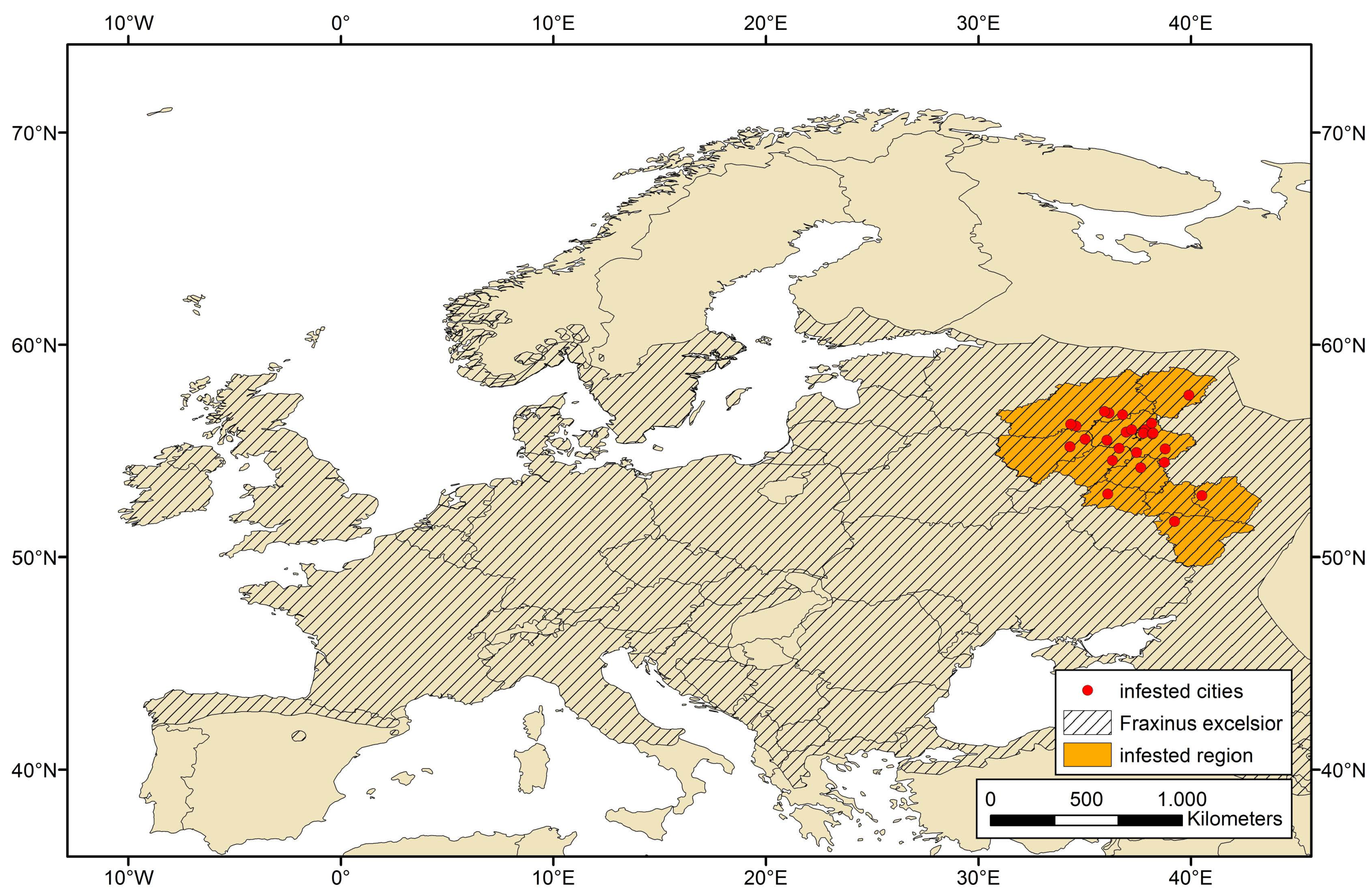
4.2. EAB Invasion Risks into Central Europe
5. Conclusions
Supplementary Files
Supplementary File 1Acknowledgments
Author Contributions
Conflicts of Interest
References
- FRAXIGEN. Ash Species in Europe: Biological Characteristics and Practical Guidelines for Sustainable Use; Oxford Forestry Institute, University of Oxford: Oxford, UK, 2015; p. 128. [Google Scholar]
- EPPO. Data Sheet Agrilus planipennis. Bull. OEPP/EPPO Bull. 2005, 35, 436–438. [Google Scholar]
- Baranchikov, Y.; Mozolevskayam, E.; Yurchenko, G.; Kenis, M. Occurrence of the Emerald Ash Borer, Agrilus planipennis in Russia and its potential impact on European forestry. EPPO Bull. 2008, 38, 233–238. [Google Scholar] [CrossRef]
- Schmiedel, D.; Tackenberg, O. Hydrochory and water induced germination enhance invasion of Fraxinus pennsylvanica. Forest Ecol. Manag. 2014, 304, 437–443. [Google Scholar] [CrossRef]
- Kovacs, K.F.; Haight, R.G.; McCullough, D.G.; Mercader, R.J.; Siegert, N.W.; Liebhold, A.M. Cost of potential Emerald Ash Borer damage in U.S. communities, 2009–2019. Ecol. Econ. 2010, 69, 569–578. [Google Scholar]
- Orlova-Bienkowskaja, M.J. Ashes in Europe are in danger: The invasive range of Agrilus planipennis in European Russia is expanding. Biol. Invasions 2013, 16, 1345–1349. [Google Scholar] [CrossRef]
- Valenta, V.; Moser, D.; Essl, F. A new forest pathogen in Europe: A review of the biology, ecology, and impacts caused by the Emerald Ash Borer (Agrilus planipennis). Biod. Conserv. 2015. submitted. [Google Scholar]
- Kuttner, M.; Essl, F.; Peterseil, J.; Dullinger, S.; Rabitsch, W.; Schindler, S.; Hülber, K.; Gattringer, A.; Moser, D. A new high-resolution habitat distribution map for Austria, Liechtenstein, southern Germany, South Tyrol and Switzerland. Eco.Mont 2015, 7. [Google Scholar] [CrossRef]
- Kempeneers, P.; Sedano, F.; Seebach, L.; Strobl, P.; San-Miguel-Ayanz, J. Data Fusion of Different Spatial Resolution Remote Sensing Images Applied to Forest-Type Mapping. IEEE Trans. Geosci. Remote Sens. 2011, 49, 4977–4986. [Google Scholar] [CrossRef]
- Bauerhansl, C.; Koukal, T.; Schadauer, K. Erste österreichweite Waldkarte basierend auf der Österreichischen Waldinventur. Available online: http://www.waldwissen.net/themen/inventur_monitoring/fernerkundung/bfw_waldlayer_2008_DE. 02.01.2008 (accessed on 08 December 2014).
- EUFORGEN. Distribution map of Common Ash (Fraxinus excelsior). EUFORGEN Secretariat: Rome, Italy. Available online: http://www.euforgen.org (accessed on 08 December 2014).
- Straw, N.A.; Williams, D.T.; Kulinich, O.; Gninenko, Y.I. Distribution, impact and rate of spread of Emerald Ash Borer Agrilus planipennis (Coleoptera: Buprestidae) in the Moscow region of Russia. Forestry 2013, 86, 515–522. [Google Scholar] [CrossRef]
- Die Wälder und Gebüsche Österreichs. Ein Bestimmungswerk mit Tabellen; Willner, W.; Grabherr, G. (Eds.) Spektrum Akademischer Verlag: Heidelberg, Germany, 2007.
- Willner, W.; Berg, C.; Heiselmayer, P. Austrian Vegetation Database. Biod. Ecol. 2012, 4, 333. [Google Scholar]
- Schadauer, K. Baumartenatlas für Österreich: Die Verbreitung der Baumarten nach Daten der Oesterreichischen Waldinventur. In FBVA-Berichte; Forstl. Bundesversuchsanst, Waldforschungszentrum: Vienna, Austria, 1994; Volume 76, p. 126. [Google Scholar]
- Lazwoski, W.; Schwarz, U.; Essl, F.; Götzl, M.; Peterseil, J.; Egger, G. Aueninventar Österreich; Final Report; BMLFUW: Vienna, Austria, 2011. [Google Scholar]
- Brunotte, E.; Dister, E.; Günther-Diringer, D.; Kuenzen, U.; Mehl, D. Flussauen in Deutschland: Erfassung und Bewertung des Auenzustandes. In Naturschutz und Biologische Vielfalt; BfN-Schriftenvertrieb im Landwirtschaftsverl: Bonn, Germany, 2010; Volume 87, p. 244. [Google Scholar]
- BAFU. Bundesinventar der Auengebiete von nationaler Bedeutung. GIS-Daten Biodiversität. Bundesamt für Umwelt. 2014. Available online: http://www.bafu.admin.ch/gis/02911/07403/index.html?lang=de (accessed on 24 July 2014).
- Bonde, A. Stellungnahme des Ministeriums für Ländlichen Raum und Verbraucherschutz zu Eschensterben in Deutschland und Baden-Württemberg. In Drucksache 15/5503, 16.07.2014; Landtag von Baden-Württemberg: Stuttgart, Germany, 2014. [Google Scholar]
- Schweizerisches Landesforstinventar: Ergebnisse der dritten Erhebung 2004–2006; Brändli, U.B. (Ed.) Eidgenössische Forschungsanstalt für Wald, Schnee und Landschaft WSL: Birmensdorf, Switzerland, 2010; p. 312.
- Immler, T. Die Esche im Staatswald der Forstdirektion Oberbayern-Schwaben. In Beiträge zur Esche—Fachtagung zum Baum des Jahres 2001. LWF-Wissen 34; Bayerische Landesanstalt für Wald und Forstwirtschaft (LWF): München, Germany, 2002. [Google Scholar]
- Autonome Provinz Bozen-Südtirol. Abteilung Forstwirtschaft Abteilung Forstwirtschaft: Die Hauptbaumarten Südtirols. 2014. Available online: http://www.provinz.bz.it/forst/wald-holz-almen/1846.asp (accessed on 8 December 2014).
- Eurostat. Available online: http://ec.europa.eu/eurostat/web/nuts/overview (accessed on 9 December 2014).
- Pautasso, M.; Ass, G.; Queloz, V.; Holdenrieder, O. European ash (Fraxinus excelsior) dieback—A conservation biology challenge. Biol. Conserv. 2013, 158, 37–49. [Google Scholar] [CrossRef]
- Hauk, E. Bäume und Sträucher-Ihre Verbreitung. Beilage zur Österreichischen Forstzeitung 12/1997. Available online: https://bfw.ac.at/inst7/publ/oefz12-97/hauk.html (accessed on 8 December 2014).
- EFSA. Statement on a heat treatment to control Agrilus planipennis. Eur. Food Saf. Auth. J. 2012. Available online: http://www.efsa.europa.eu/en/efsajournal/doc/2646.pdf. (accessed on 19 November 2014).
- Forestry Commission. Importing Wood, Wood Products and Bark, 2nd ed.Forestry Commission: Edinburgh. Available online: http://www.forestry.gov.uk/pdf/FCPH001.pdf/$FILE/FCPH001.pdf (accessed on 15 November 2014).
- Banks, N.C.; Paini, D.R.; Bayliss, K.L.; Hoddda, M. The role of global trade and transport network topology in the human-mediated dispersal of alien species. Ecol. Lett. 2014, 18, 188–199. [Google Scholar] [CrossRef] [PubMed]
- Crosthwaite, J.C.; Crosthwaite, J.C.; Sobek, S.; Lyons, D.B.; Bernards, M.A.; Sinclair, B.J. The overwintering physiology of the Emerald Ash Borer, Agrilus planipennis Fairmaire (Coleoptera: Buprestidae). J. Insect Phys. 2011, 57, 166–173. [Google Scholar] [CrossRef] [PubMed]
- Sobek, S.; Rajamohan, A.; Dillon, D.; Cumming, R.C.; Sinclair, B.J. High temperature tolerance and thermal plasticity in Emerald Ash Borer Agrilus planipennis. Agric. Forest Entomol. 2011, 13, 333–340. [Google Scholar] [CrossRef]
- Muirhead, J.R.; Leung, B.; van Overdijk, C.; Kelly, D.W.; Nandakumar, K.; Marchant, K.R.; MacIsaac, H.J. Modelling local and long-distance dispersal of invasive Emerald Ash Borer Agrilus planipennis (Coleoptera) in North America. Divers. Distrib. 2006, 12, 71–79. [Google Scholar] [CrossRef]
- Prasad, A.M.; Iverson, M.R.; Peters, M.P.; Bossenbroek, J.M.; Matthews, S.N.; Syndor, T.D.; Schwartz, M.W. Modeling the invasive Emerald Ash Borer risk of spread using a spatially explicit cellular model. Landsc. Ecol. 2010, 25, 353–369. [Google Scholar] [CrossRef]
- Essl, F.; Egger, G. Lebensraumvielfalt in Österreich; Environment Agency: Vienna, Austria, 2010. [Google Scholar]
© 2015 by the authors; licensee MDPI, Basel, Switzerland. This article is an open access article distributed under the terms and conditions of the Creative Commons Attribution license (http://creativecommons.org/licenses/by/4.0/).
Share and Cite
Valenta, V.; Moser, D.; Kuttner, M.; Peterseil, J.; Essl, F. A High-Resolution Map of Emerald Ash Borer Invasion Risk for Southern Central Europe. Forests 2015, 6, 3075-3086. https://doi.org/10.3390/f6093075
Valenta V, Moser D, Kuttner M, Peterseil J, Essl F. A High-Resolution Map of Emerald Ash Borer Invasion Risk for Southern Central Europe. Forests. 2015; 6(9):3075-3086. https://doi.org/10.3390/f6093075
Chicago/Turabian StyleValenta, Viktoria, Dietmar Moser, Michael Kuttner, Johannes Peterseil, and Franz Essl. 2015. "A High-Resolution Map of Emerald Ash Borer Invasion Risk for Southern Central Europe" Forests 6, no. 9: 3075-3086. https://doi.org/10.3390/f6093075
APA StyleValenta, V., Moser, D., Kuttner, M., Peterseil, J., & Essl, F. (2015). A High-Resolution Map of Emerald Ash Borer Invasion Risk for Southern Central Europe. Forests, 6(9), 3075-3086. https://doi.org/10.3390/f6093075