
Sparse Density, Leaf-Off Airborne Laser Scanning Data in Aboveground Biomass Component Prediction


 ,
, 
Abstract
:1. Introduction
2. Materials and Methods
2.1. Study Area and Field Measurements

| MIN | MEAN | MAX | STDEV | |
|---|---|---|---|---|
| Dgm, mm | 77.7 | 227.9 | 558.5 | 79.2 |
| Hgm, m | 5.1 | 19.0 | 31.0 | 5.2 |
| V, m3/ha | 4.7 | 205.9 | 653.6 | 113.5 |
| N, 1/ha | 133.0 | 1007.8 | 3001.0 | 599.3 |
| TotalB, t/ha | 2.8 | 104.8 | 302.8 | 53.1 |
| StemB, t/ha | 1.3 | 74.3 | 208.9 | 38.2 |
| CanopyB, t/ha | 0.8 | 24.1 | 88.2 | 13.9 |
| LivB, t/ha | 0.6 | 14.0 | 40.6 | 7.2 |
2.2. Airborne Laser Scanning Data
Metric Extraction
2.3. Biomass Prediction and Accuracy Assessment
2.4. Biomass Estimates Based on the Multi-Source National Forest Inventory
3. Results
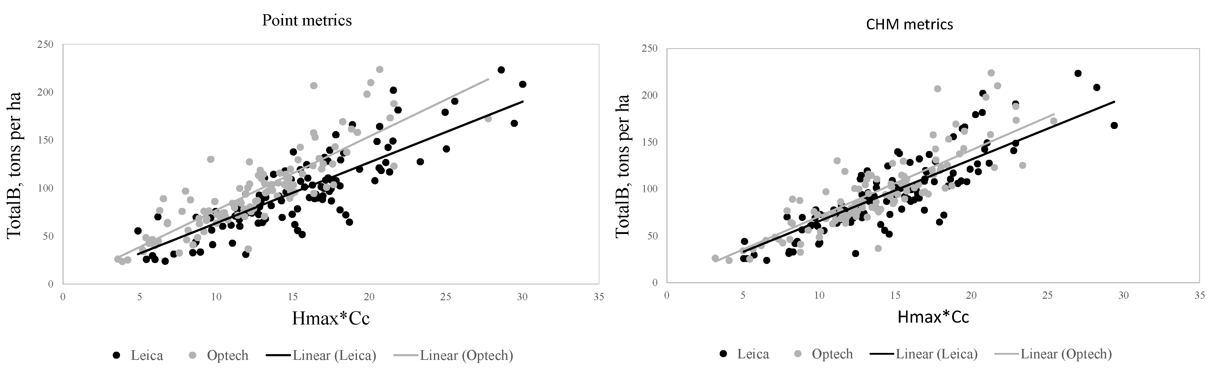
3.1. The Effect on Scanning Equipment on the Biomass Prediction Accuracy
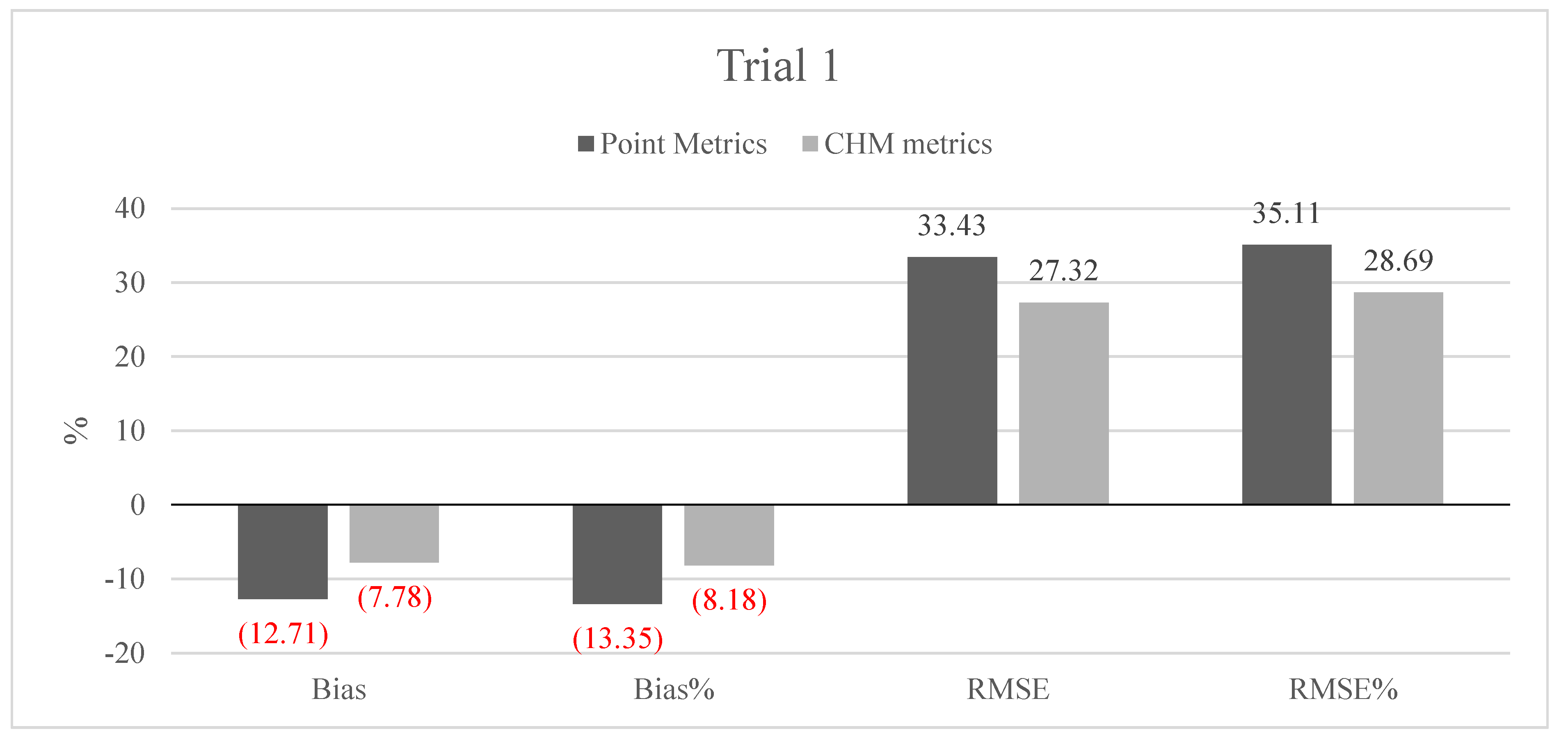
| Point metrics | CHM metrics | |||||||
|---|---|---|---|---|---|---|---|---|
| % | RMSE | RMSE% | % | RMSE | RMSE% | |||
| TotalB | −12.7 | −13.4 | 33.4 | 35.1 | −7.8 | −8.2 | 27.3 | 28.7 |
| CanopyB | −2.6 | −11.9 | 11.7 | 53.5 | −1.6 | −7.2 | 11.4 | 52.0 |
| StemB | −10.1 | −15.1 | 24.4 | 36.6 | −7.4 | −11.0 | 20.5 | 30.7 |
| LivB | −1.8 | −13.6 | 5.1 | 39.3 | −1.0 | −7.9 | 4.4 | 33.9 |
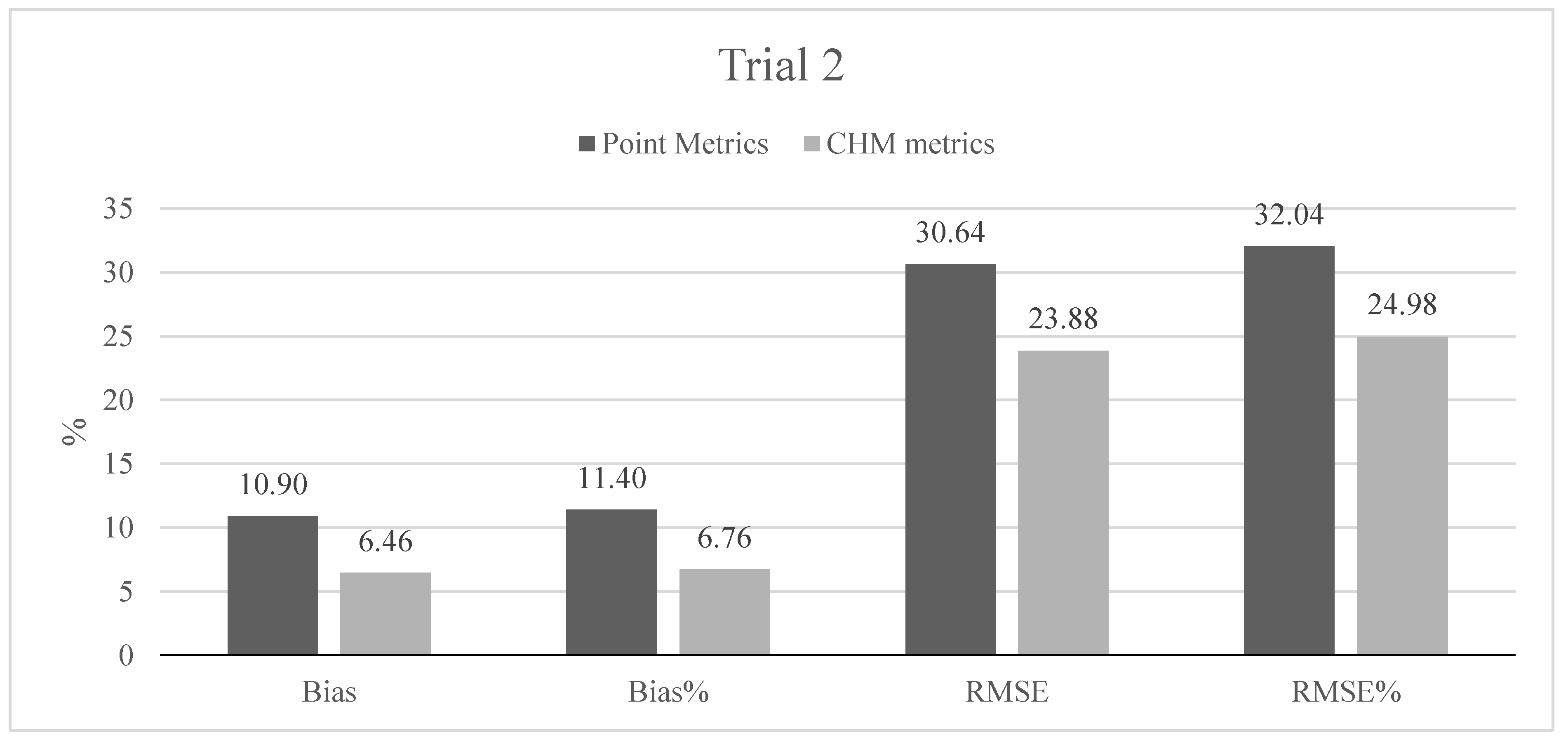
| Point metrics | CHM metrics | |||||||
|---|---|---|---|---|---|---|---|---|
| % | RMSE | RMSE% | % | RMSE | RMSE% | |||
| TotalB | 10.9 | 11.4 | 30.6 | 32.0 | 6.5 | 6.8 | 23.9 | 25.0 |
| CanopyB | 2.1 | 9.4 | 12.3 | 55.3 | 0.5 | 2.1 | 11.9 | 53.1 |
| StemB | 8.6 | 12.6 | 22.2 | 32.4 | 5.9 | 8.6 | 17.8 | 25.9 |
| LivB | 1.5 | 11.5 | 5.0 | 38.5 | 0.8 | 6.0 | 4.3 | 33.1 |

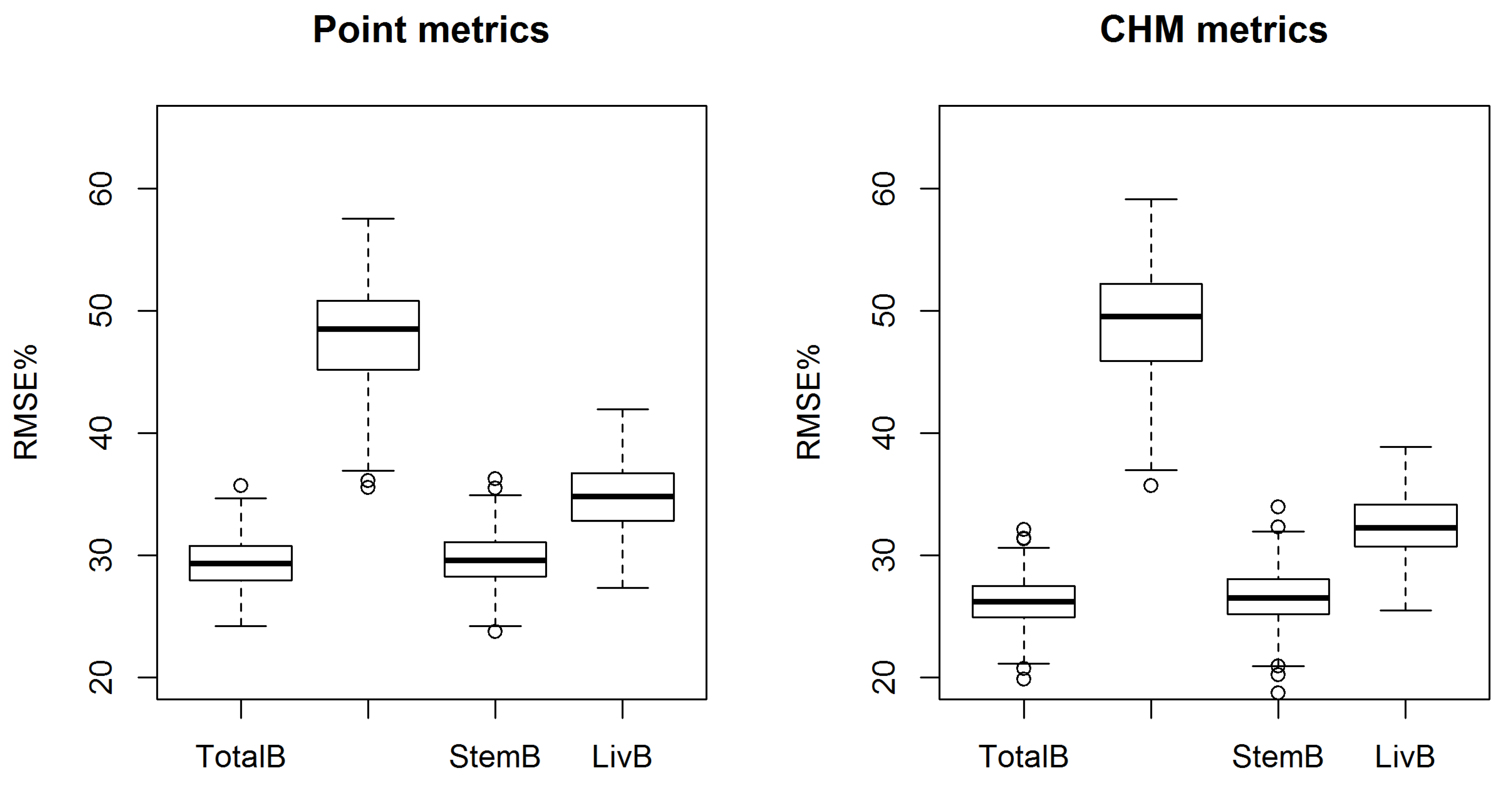
3.2. Aboveground Biomass Component Prediction Accuracy
| Point metrics | ||||||||
| % | RMSE% | |||||||
| Min | Mean | Max | Std | Min | Mean | Max | Std | |
| TotalB | −12.4 | −0.6 | 9.8 | 4.0 | 23.5 | 29.7 | 38.6 | 2.1 |
| CanopyB | −19.2 | −0.8 | 15.4 | 6.2 | 38.0 | 48.3 | 58.8 | 3.9 |
| StemB | −11.1 | −0.4 | 10.4 | 4.0 | 23.2 | 29.9 | 37.9 | 2.1 |
| LivB | −14.6 | −1.0 | 12.1 | 4.6 | 27.4 | 35.1 | 42.5 | 2.7 |
| CHM metrics | ||||||||
| % | RMSE% | |||||||
| Min | Mean | Max | Std | Min | Mean | Max | Std | |
| TotalB | −10.6 | −0.1 | 9.6 | 3.5 | 21.0 | 26.4 | 36.0 | 1.9 |
| CanopyB | −22.5 | −0.7 | 16.7 | 6.6 | 38.1 | 49.6 | 63.5 | 4.2 |
| StemB | −10.6 | −0.1 | 10.5 | 3.5 | 21.2 | 26.7 | 35.6 | 2.0 |
| LivB | −13.5 | −0.4 | 11.1 | 4.3 | 24.7 | 32.6 | 39.5 | 2.6 |
4. Discussion
5. Conclusions
Acknowledgments
Author Contributions
Appendix
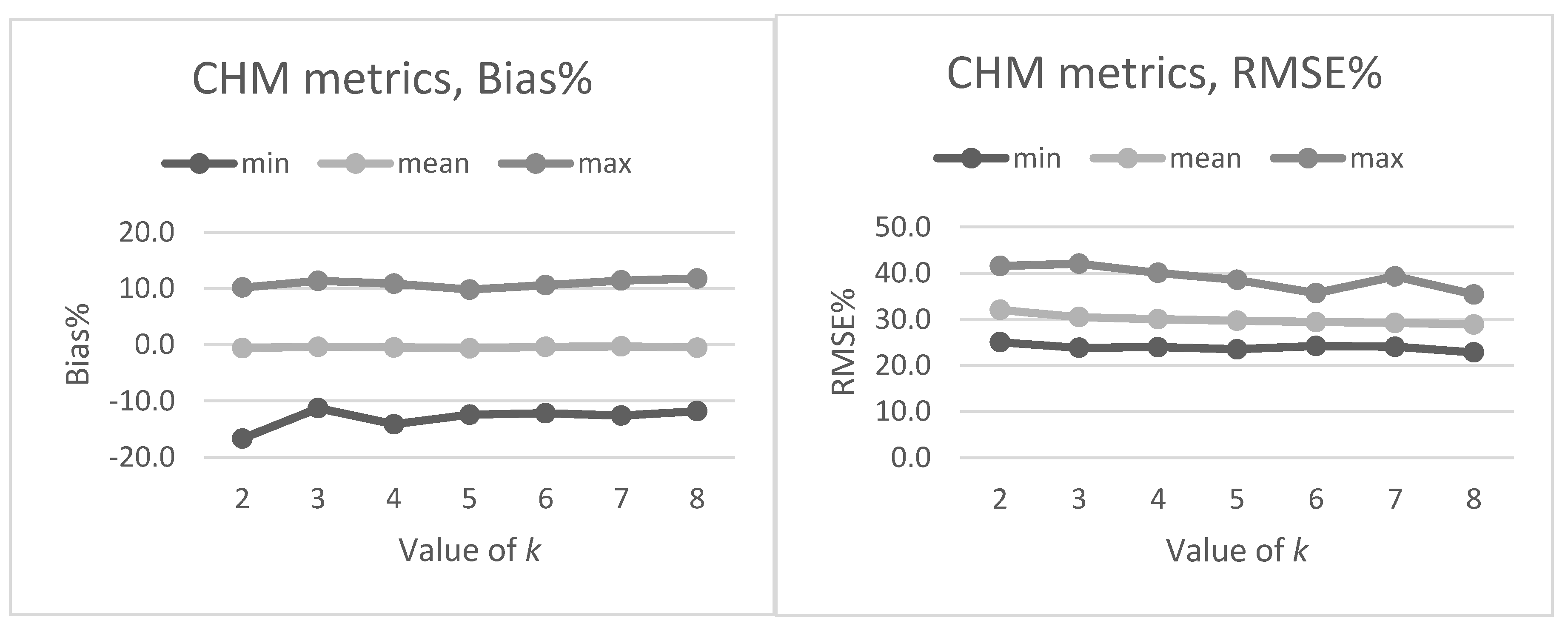
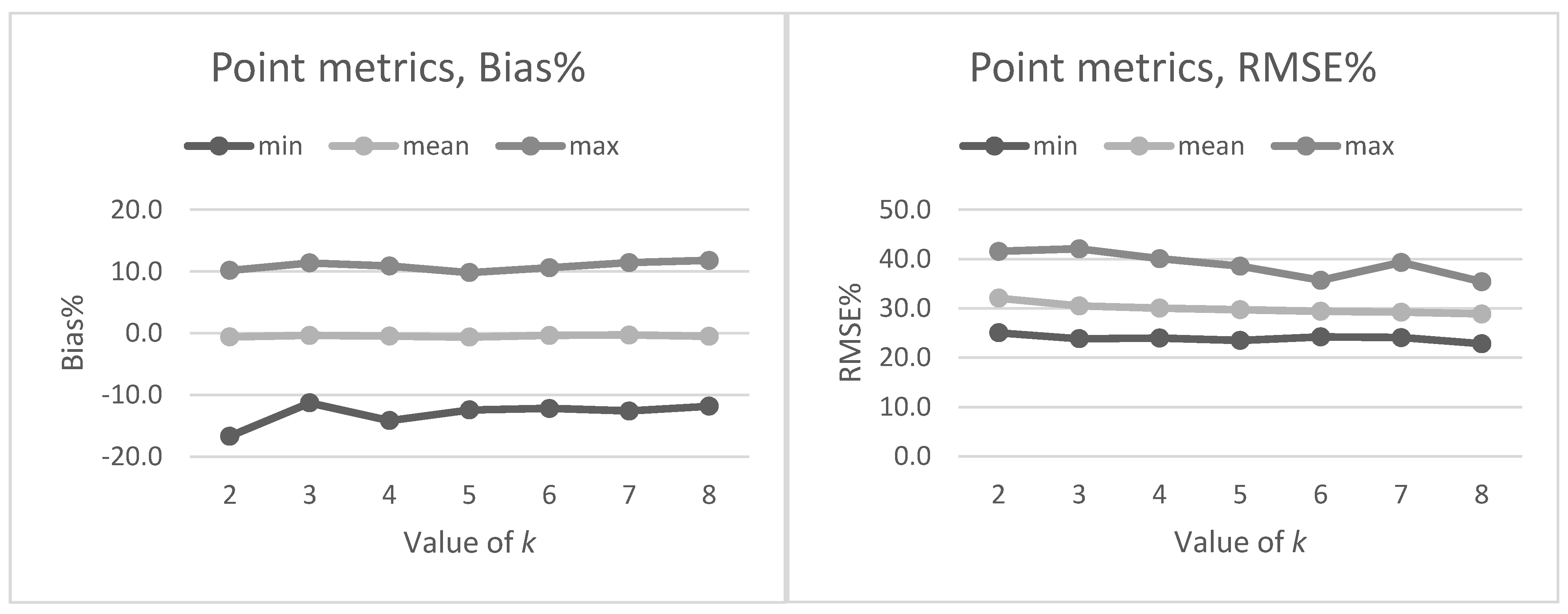
A. Tuning the Value of k in NN Predictions
| k−value | |||||||
|---|---|---|---|---|---|---|---|
| 2 | 3 | 4 | 5 | 6 | 7 | 8 | |
| BIAS% | |||||||
| min | −16.7 | −11.3 | −14.1 | −12.4 | −12.2 | −12.6 | −11.8 |
| mean | −0.6 | −0.3 | −0.5 | −0.6 | −0.4 | −0.3 | −0.5 |
| max | 10.2 | 11.4 | 10.9 | 9.8 | 10.6 | 11.4 | 11.8 |
| RMSE% | |||||||
| min | 25.0 | 23.8 | 24.0 | 23.5 | 24.2 | 24.1 | 22.8 |
| mean | 32.1 | 30.5 | 30.0 | 29.7 | 29.4 | 29.2 | 28.9 |
| max | 41.6 | 42.1 | 40.1 | 38.6 | 35.7 | 39.3 | 35.4 |
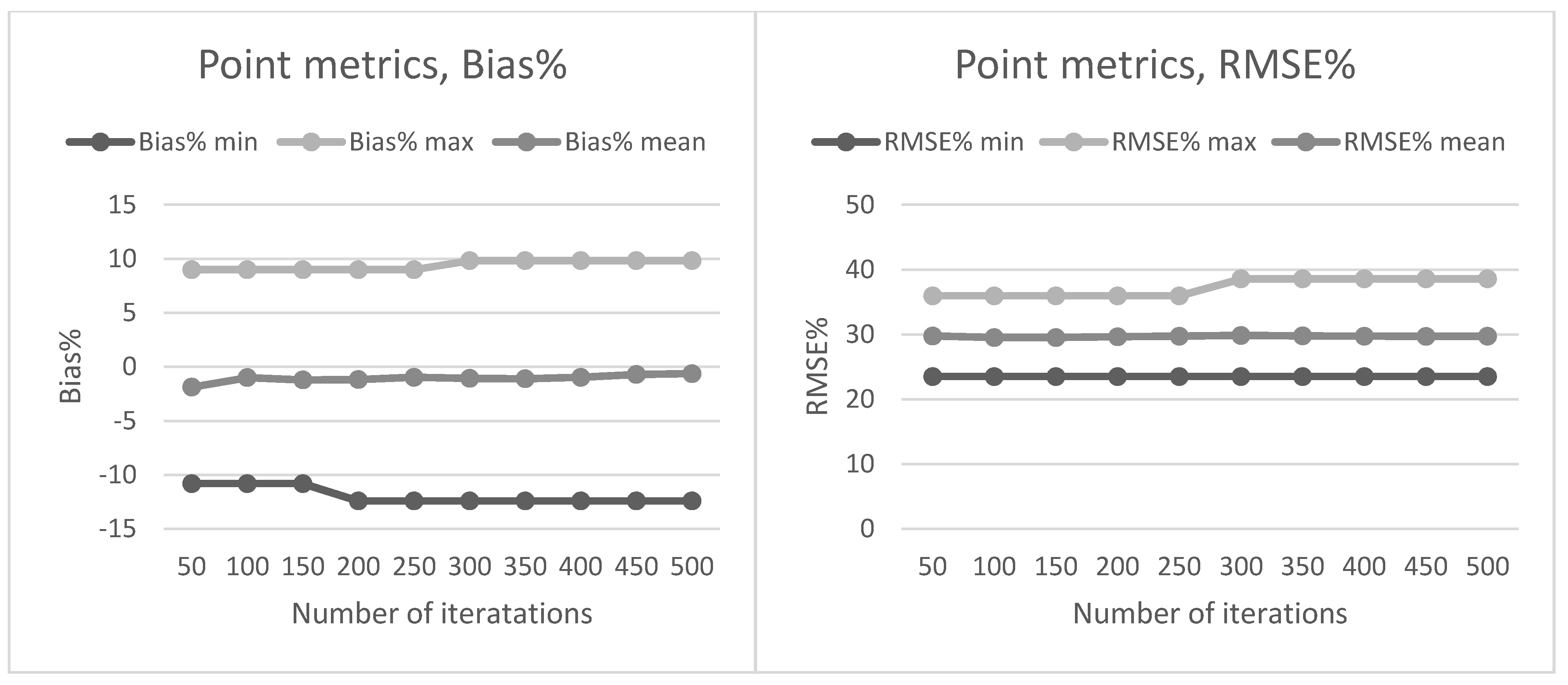
| Value of k | |||||||
|---|---|---|---|---|---|---|---|
| 2 | 3 | 4 | 5 | 6 | 7 | 8 | |
| BIAS% | |||||||
| min | −10.8 | −10.7 | −10.7 | −10.6 | −9.7 | −13.5 | −11.3 |
| mean | 0.1 | 0.1 | 0.0 | −0.1 | 0.2 | 0.1 | −0.1 |
| max | 10.2 | 10.6 | 9.9 | 9.6 | 10.3 | 9.8 | 13.3 |
| RMSE% | |||||||
| min | 23.1 | 20.8 | 21.7 | 21.0 | 19.9 | 20.6 | 20.2 |
| mean | 28.8 | 27.5 | 26.8 | 26.4 | 26.2 | 25.9 | 25.7 |
| max | 34.4 | 32.7 | 35.4 | 36.0 | 32.1 | 32.6 | 31.2 |

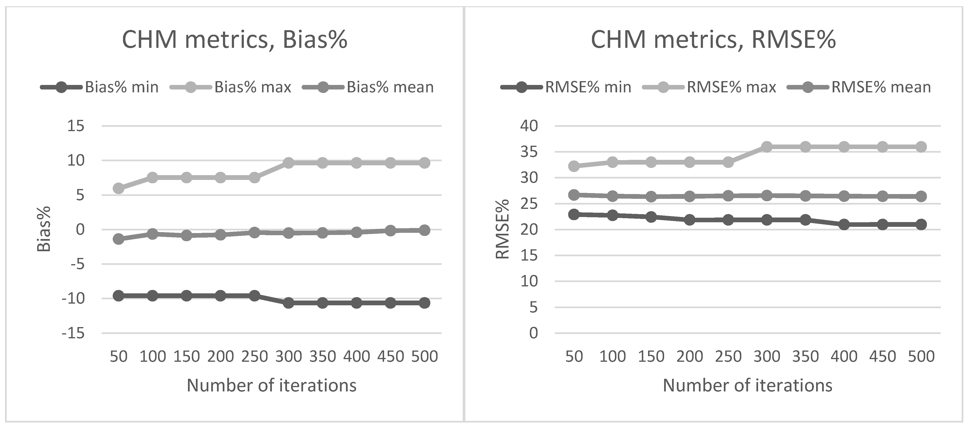
B. Tuning the Number of Iterations in NN Predictions
Conflicts of Interest
References
- Repola, J. Biomass Equations for Birch in Finland. Silva Fenn. 2008, 42, 605–624. [Google Scholar] [CrossRef]
- Repola, J. Biomass equations for Scots pine and Norway spruce in Finland. Silva Fenn. 2009, 43, 625–647. [Google Scholar] [CrossRef]
- Tomppo, E.; Olsson, H.; Ståhl, G.; Nilsson, M.; Hagner, O.; Katila, M. Combining national forest inventory field plots and remote sensing data for forest databases. Remote Sens. Environ. 2008, 112, 1982–1999. [Google Scholar] [CrossRef]
- Lu, D. The potential and challenge of remote sensing-based biomass estimation. Int. J. Remote Sens. 2006, 27, 1297–1328. [Google Scholar] [CrossRef]
- Tuominen, S.; Eerikäinen, K.; Schibalski, A.; Haakana, M.; Lehtonen, A. Mapping biomass variables with a multi-source forest inventory technique. Silva Fenn. 2010, 44, 109–117. [Google Scholar] [CrossRef]
- Næsset, E. Determination of mean tree height of forest stands using airborne laser scanner data. ISPRS J. Photogramm. Remote Sens. 1997, 52, 49–56. [Google Scholar] [CrossRef]
- White, J.C.; Wulder, M.A.; Varhola, A.; Vastaranta, M.; Coops, N.C.; Cook, B.D.; Pitt, D.; Woods, M. A best practices guide for generating forest inventory attributes from airborne laser scanning data using an area-based approach. For. Chron. 2013, 89, 722–723. [Google Scholar] [CrossRef]
- Hyyppä, J.; Inkinen, M. Detecting and estimating attributes for single trees using laser scanner. Photogramm. J. Finl. 1999, 16, 27–42. [Google Scholar]
- Hauglin, M.; Gobakken, T.; Astrup, R.; Ene, L.; Næsset, E. Estimating Single-Tree Crown Biomass of Norway Spruce by Airborne Laser Scanning: A Comparison of Methods with and without the Use of Terrestrial Laser Scanning to Obtain the Ground Reference Data. Forests 2014, 5, 384–403. [Google Scholar] [CrossRef]
- Kankare, V.; Holopainen, M.; Vastaranta, M.; Puttonen, E.; Yu, X.; Hyyppä, J. Individual tree biomass estimation using terrestrial laser scanning. ISPRS J. Photogramm. Remote Sens. 2013, 75, 64–75. [Google Scholar] [CrossRef]
- Kankare, V.; Räty, M.; Yu, X.; Holopainen, M.; Vastaranta, M.; Kantola, T.; Hyyppä, J.; Hyyppä, H.; Alho, P.; Viitala, R. Single tree biomass modelling using airborne laser scanning. ISPRS J. Photogramm. Remote Sens. 2013, 85, 66–73. [Google Scholar] [CrossRef]
- Popescu, S.C. Estimating biomass of individual pine trees using airborne lidar. Biomass Bioenergy 2007, 31, 646–655. [Google Scholar] [CrossRef]
- Hauglin, M.; Dibdiakova, J.; Gobakken, T.; Næsset, E. Estimating single-tree branch biomass of Norway spruce by airborne laser scanning. ISPRS J. Photogramm. Remote Sens. 2013, 79, 147–156. [Google Scholar] [CrossRef]
- Hauglin, M.; Astrup, R.; Gobakken, T.; Næsset, E. Estimating single-tree branch biomass of Norway spruce with terrestrial laser scanning using voxel-based and crown dimension features. Scand. J. For. Res. 2013, 28, 456–469. [Google Scholar] [CrossRef]
- Zolkos, S.G.; Goetz, S.J.; Dubayah, R. A meta-analysis of terrestrial aboveground biomass estimation using lidar remote sensing. Remote Sens. Environ. 2013, 128, 289–298. [Google Scholar] [CrossRef]
- Popescu, S.C.; Hauglin, M. Estimation of biomass components by airborne laser scanning. In Forestry Applications of Airborne Laser Scanning—Concepts and Case Studies; Maltamo, M., Næsset, E., Vauhkonen, J., Eds.; Managing Forest Ecosystems 27; Springer: Dordrecht, The Netherlands, 2014; pp. 157–175. [Google Scholar]
- Popescu, S.C.; Wynne, R.H.; Scrivani, J.A. Fusion of Small-Footprint Lidar and Multispectral Data to Estimate Plot- Level Volume and Biomass in Deciduous. For. Sci. 2004, 50, 551–565. [Google Scholar]
- Aardt, J.A.N.; van Wynne, R.H.; Oderwald, R.G. Lidar-Distributional Parameters on a Per-Segment Basis. For. Sci. 2006, 52, 636–649. [Google Scholar]
- Næsset, E. Practical Large-Scale Forest Stand Inventory Using a Small-Footprint Airborne Scanning Laser. Scand. J. For. Res. 2004, 19, 164–179. [Google Scholar] [CrossRef]
- Latifi, H.; Nothdurft, A.; Koch, B. Non-parametric prediction and mapping of standing timber volume and biomass in a temperate forest: Application of multiple optical/LiDAR-derived predictors. Forestry 2010, 83, 395–407. [Google Scholar] [CrossRef]
- Fassnacht, F.E.; Hartig, F.; Lati, H.; Berger, C.; Hernández, J.; Corvalán, P.; Koch, B. Importance of sample size, data type and prediction method for remote sensing-based estimations of aboveground forest biomass. Remote Sens. Environ. 2014, 154, 102–114. [Google Scholar] [CrossRef]
- Stepper, C.; Straub, C.; Pretzsch, H. Using semi-global matching point clouds to estimate growing stock at the plot and stand levels : Application for a broadleaf-dominated forest in central Europe. Can. J. For. Res. 2015, 123, 111–123. [Google Scholar] [CrossRef]
- Vastaranta, M.; Kankare, V.; Holopainen, M.; Yu, X.; Hyyppä, J.; Hyyppä, H. Combination of individual tree detection and area-based approach in imputation of forest variables using airborne laser data. ISPRS J. Photogramm. Remote Sens. 2012, 67, 73–79. [Google Scholar] [CrossRef]
- Kankare, V.; Vastaranta, M.; Holopainen, M.; Räty, M.; Yu, X.; Hyyppä, J.; Hyyppä, H.; Alho, P.; Viitala, R. Retrieval of forest aboveground biomass and stem volume with airborne scanning LiDAR. Remote Sens. 2013, 5, 2257–2274. [Google Scholar] [CrossRef]
- Tuominen, S.; Haapanen, R. Estimation of forest biomass by means of genetic algorithm-based optimization of airborne laser scanning and digital aerial photograph features. Silva Fenn. 2013, 47, 20. [Google Scholar] [CrossRef]
- Bohlin, J.; Wallerman, J.; Fransson, J.E.S. Forest variable estimation using photogrammetric matching of digital aerial images in combination with a high-resolution DEM. Scand. J. For. Res. 2012, 27, 692–699. [Google Scholar] [CrossRef]
- Dalponte, M.; Martinez, C.; Rodeghiero, M.; Gianelle, D. The role of ground reference data collection in the prediction of stem volume with LiDAR data in mountain areas. ISPRS J. Photogramm. Remote Sens. 2011, 66, 787–797. [Google Scholar] [CrossRef]
- Gomez-Gutierrez, A.; Schnabel, S.; Lavado-Contador, F.; Garcia-Marin, R. Testing the quality of open-access DEMs and their derived attributes in Spain : SRTM, GDEM and PNOA DEM. In Proceedings of Geomorphometry 2011 Conference, Redlands, CA, USA, 2011; pp. 53–56.
- Nord-Larsen, T.; Schumacher, J. Estimation of forest resources from a country wide laser scanning survey and national forest inventory data. Remote Sens. Environ. 2012, 119, 148–157. [Google Scholar] [CrossRef]
- Villikka, M.; Packalén, P.; Maltamo, M. The Suitability of Leaf-off Airborne Laser Scanning Data in an Area-based Forest Inventory of Coniferous and Deciduous Trees. Silva Fenn. 2012, 46, 99–110. [Google Scholar] [CrossRef]
- Næsset, E. Predicting forest stand characteristics with airborne scanning laser using a practical two-stage procedure and field data. Remote Sens. Environ. 2002, 80, 88–99. [Google Scholar] [CrossRef]
- Korhonen, L.; Peuhkurinen, J.; Malinen, J.; Suvanto, A.; Maltamo, M.; Packalén, P.; Kangas, J. The use of airborne laser scanning to estimate sawlog volumes. Forestry 2008, 81, 499–510. [Google Scholar]
- Hudak, A.T.; Crookston, N.L.; Evans, J.S.; Hall, D.E.; Falkowski, M.J. Nearest neighbor imputation of species-level, plot-scale forest structure attributes from LiDAR data. Remote Sens. Environ. 2008, 112, 2232–2245. [Google Scholar] [CrossRef]
- Crookston, N.L.; Finley, A.O. yaImpute: An R package for kNN imputation. J. Stat. Softw. 2008, 23, 1–16. [Google Scholar]
- R Core Team. R: A language and environment for statistical computing. Avaliable online: http://www.r-project.org/ (accessed on 12 January 2014).
- Tomppo, E.; Halme, M. Using coarse scale forest variables as ancillary information and weighting of variables in k-NN estimation: A genetic algorithm approach. Remote Sens. Environ. 2004, 92, 1–20. [Google Scholar] [CrossRef]
- Næsset, E. Effects of different sensors, flying altitudes, and pulse repetition frequencies on forest canopy metrics and biophysical stand properties derived from small-footprint airborne laser data. Remote Sens. Environ. 2009, 113, 148–159. [Google Scholar] [CrossRef]
- Kotamaa, E.; Tokola, T.; Maltamo, M.; Packalén, P.; Kurttila, M.; Mäkinen, A. Integration of remote sensing-based bioenergy inventory data and optimal bucking for stand-level decision making. Eur. J. For. Res. 2010, 129, 875–886. [Google Scholar] [CrossRef]
- Vastaranta, M.; Wulder, M.A.; White, J.C.; Pekkarinen, A.; Tuominen, S.; Ginzler, C.; Kankare, V.; Holopainen, M.; Hyyppa, J.; Hyyppa, H. Airborne laser scanning and digital stereo imagery measures of forest structure : Comparative results and implications to forest mapping and inventory update. Can. J. Remote Sens. 2013, 39, 382–395. [Google Scholar] [CrossRef]
- He, Q.; Chen, E.; An, R.; Li, Y. Above-Ground Biomass and Biomass Components Estimation Using LiDAR Data in a Coniferous Forest. Forests 2013, 4, 984–1002. [Google Scholar] [CrossRef]
- Næsset, E.; Gobakken, T. Estimation of above- and below-ground biomass across regions of the boreal forest zone using airborne laser. Remote Sens. Environ. 2008, 112, 3079–3090. [Google Scholar] [CrossRef]
- Næsset, E.; Gobakken, T.; Bollandsås, O.M.; Gregoire, T.G.; Nelson, R.; Ståhl, G. Comparison of precision of biomass estimates in regional field sample surveys and airborne LiDAR-assisted surveys in Hedmark County, Norway. Remote Sens. Environ. 2013, 130, 108–120. [Google Scholar] [CrossRef]
© 2015 by the authors; licensee MDPI, Basel, Switzerland. This article is an open access article distributed under the terms and conditions of the Creative Commons Attribution license (http://creativecommons.org/licenses/by/4.0/).
Share and Cite
Kankare, V.; Vauhkonen, J.; Holopainen, M.; Vastaranta, M.; Hyyppä, J.; Hyyppä, H.; Alho, P. Sparse Density, Leaf-Off Airborne Laser Scanning Data in Aboveground Biomass Component Prediction. Forests 2015, 6, 1839-1857. https://doi.org/10.3390/f6061839
Kankare V, Vauhkonen J, Holopainen M, Vastaranta M, Hyyppä J, Hyyppä H, Alho P. Sparse Density, Leaf-Off Airborne Laser Scanning Data in Aboveground Biomass Component Prediction. Forests. 2015; 6(6):1839-1857. https://doi.org/10.3390/f6061839
Chicago/Turabian StyleKankare, Ville, Jari Vauhkonen, Markus Holopainen, Mikko Vastaranta, Juha Hyyppä, Hannu Hyyppä, and Petteri Alho. 2015. "Sparse Density, Leaf-Off Airborne Laser Scanning Data in Aboveground Biomass Component Prediction" Forests 6, no. 6: 1839-1857. https://doi.org/10.3390/f6061839
APA StyleKankare, V., Vauhkonen, J., Holopainen, M., Vastaranta, M., Hyyppä, J., Hyyppä, H., & Alho, P. (2015). Sparse Density, Leaf-Off Airborne Laser Scanning Data in Aboveground Biomass Component Prediction. Forests, 6(6), 1839-1857. https://doi.org/10.3390/f6061839