
Comparison of Algorithms and Optimal Feature Combinations for Identifying Forest Type in Subtropical Forests Using GF-2 and UAV Multispectral Images

 , ,
, ,
Abstract
1. Introduction
2. Materials and Methods
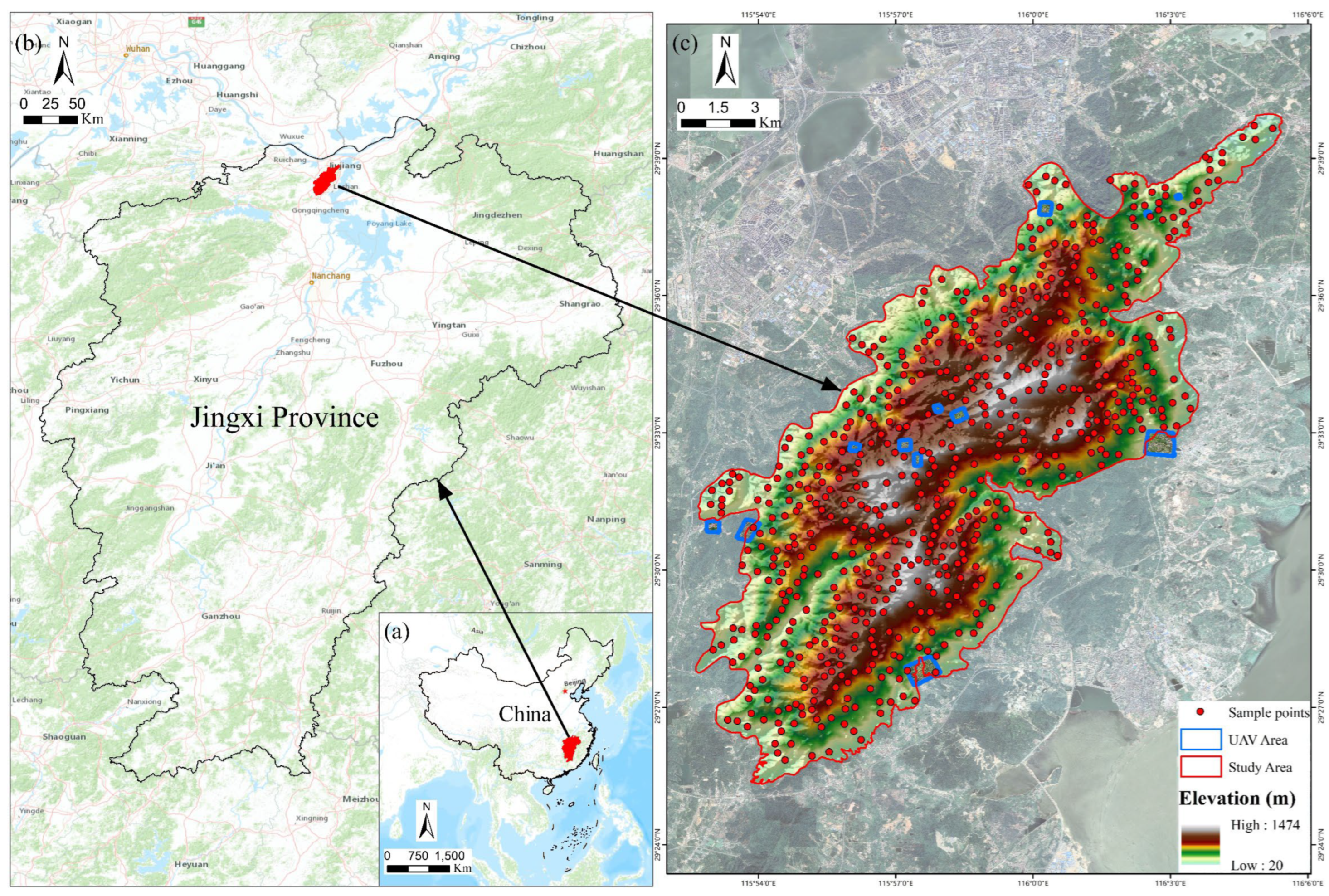
2.1. Study Area
2.2. Image Data and Pre-Processing
2.3. Classification System and Sample Dataset
2.3.1. Classification System
2.3.2. Sample Dataset
2.4. Methods
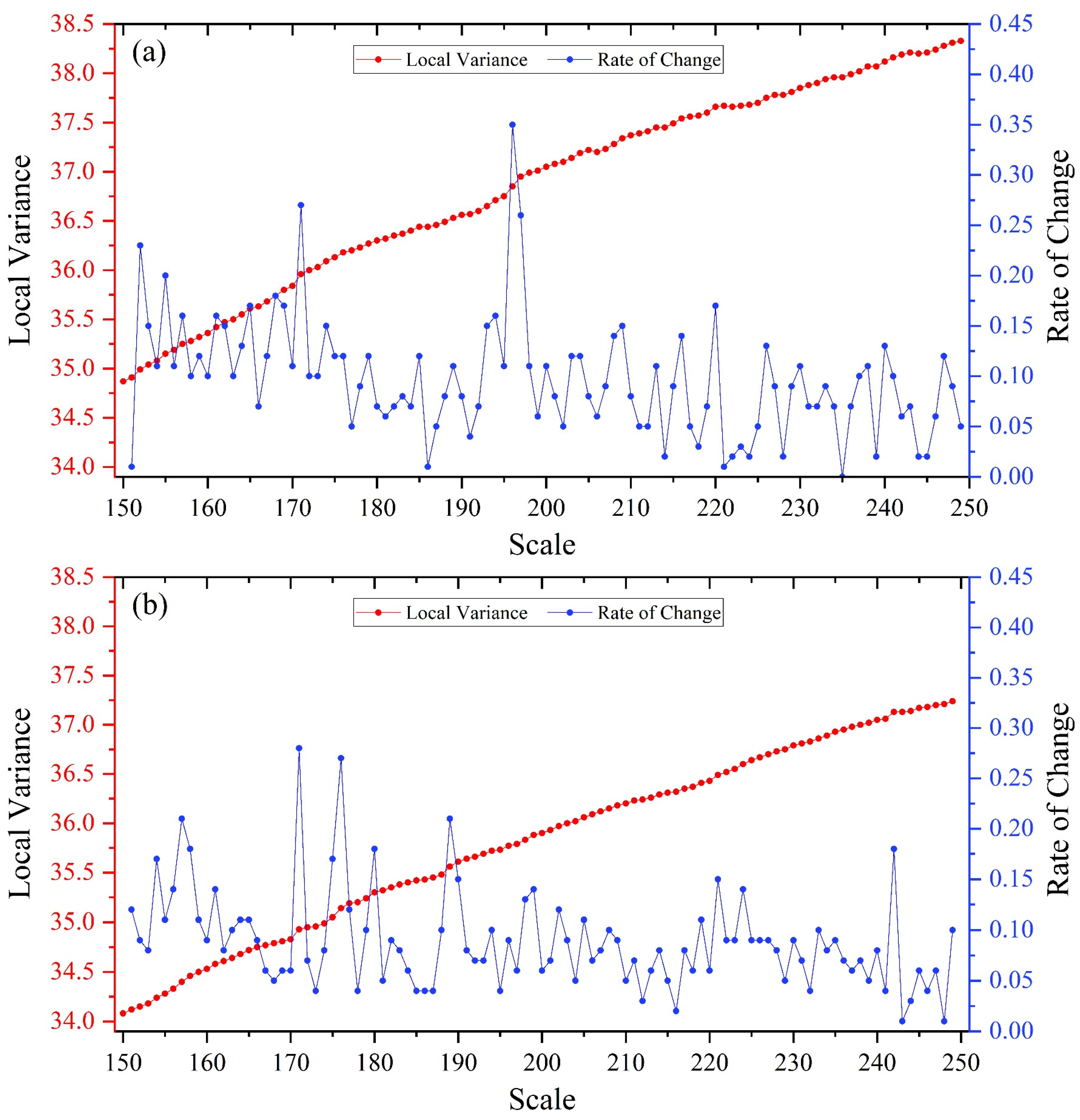
2.4.1. Image Segmentation
2.4.2. Feature Extraction
2.4.3. Feature Combination Scheme
2.4.4. Classification Algorithm
2.4.5. Accuracy Assessment
3. Result
3.1. Image Segmentation Results
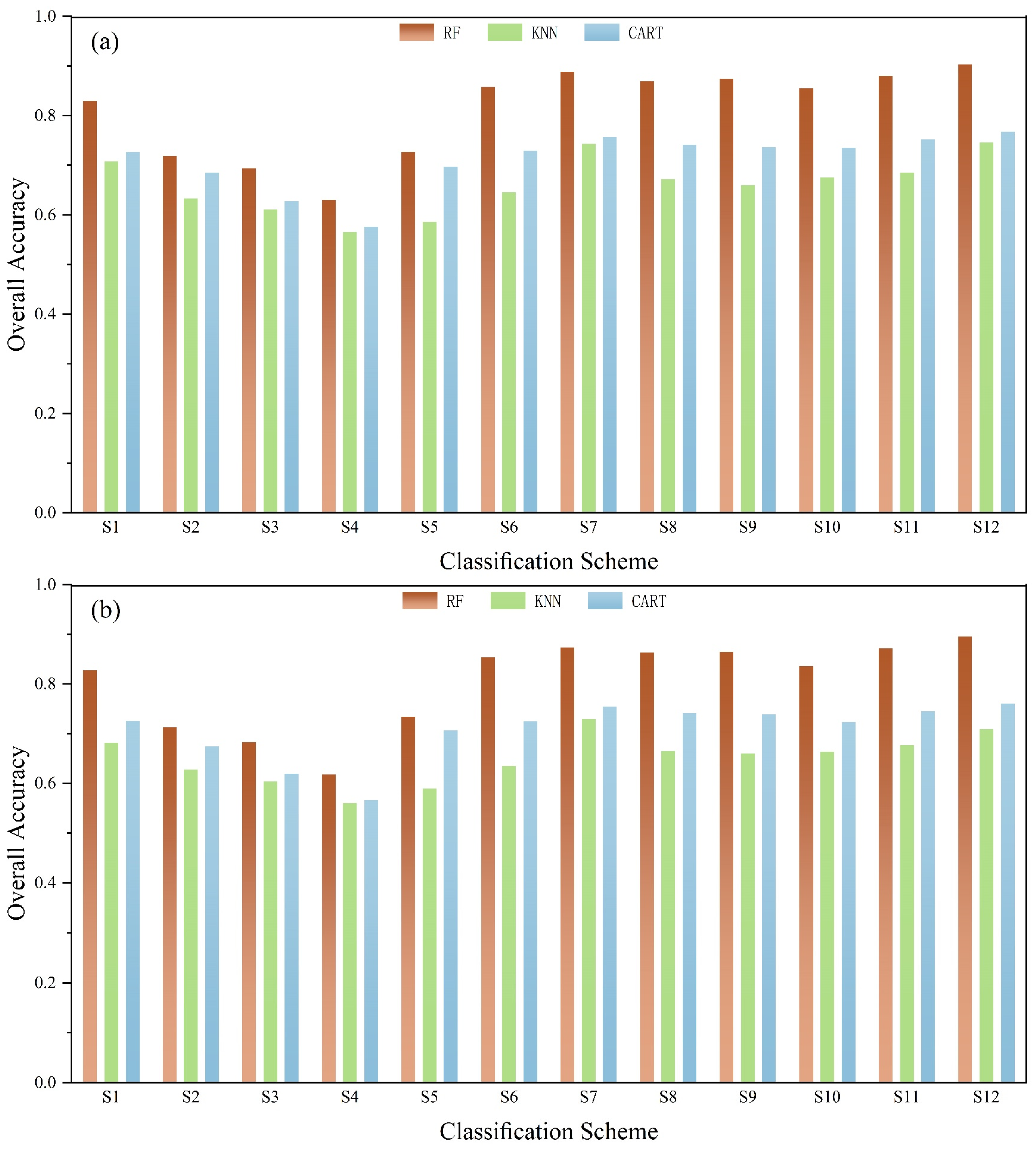
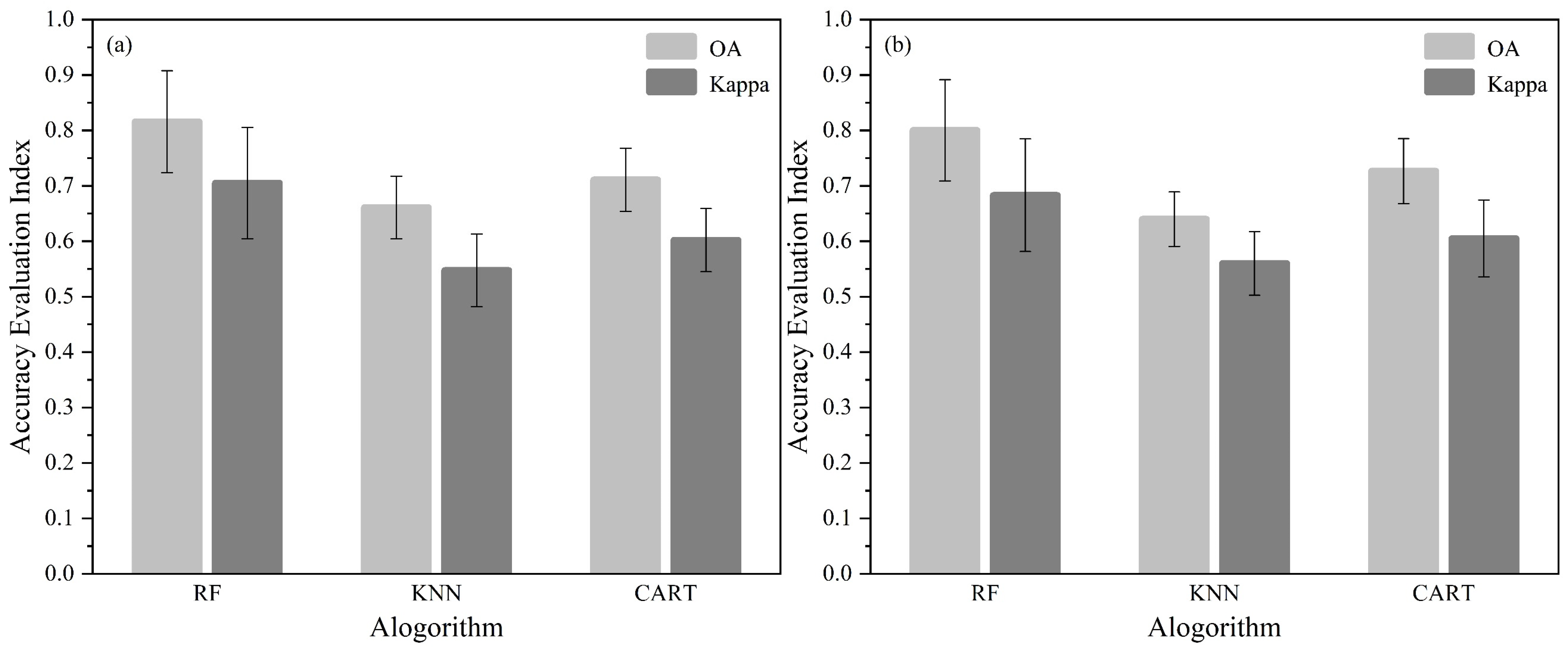
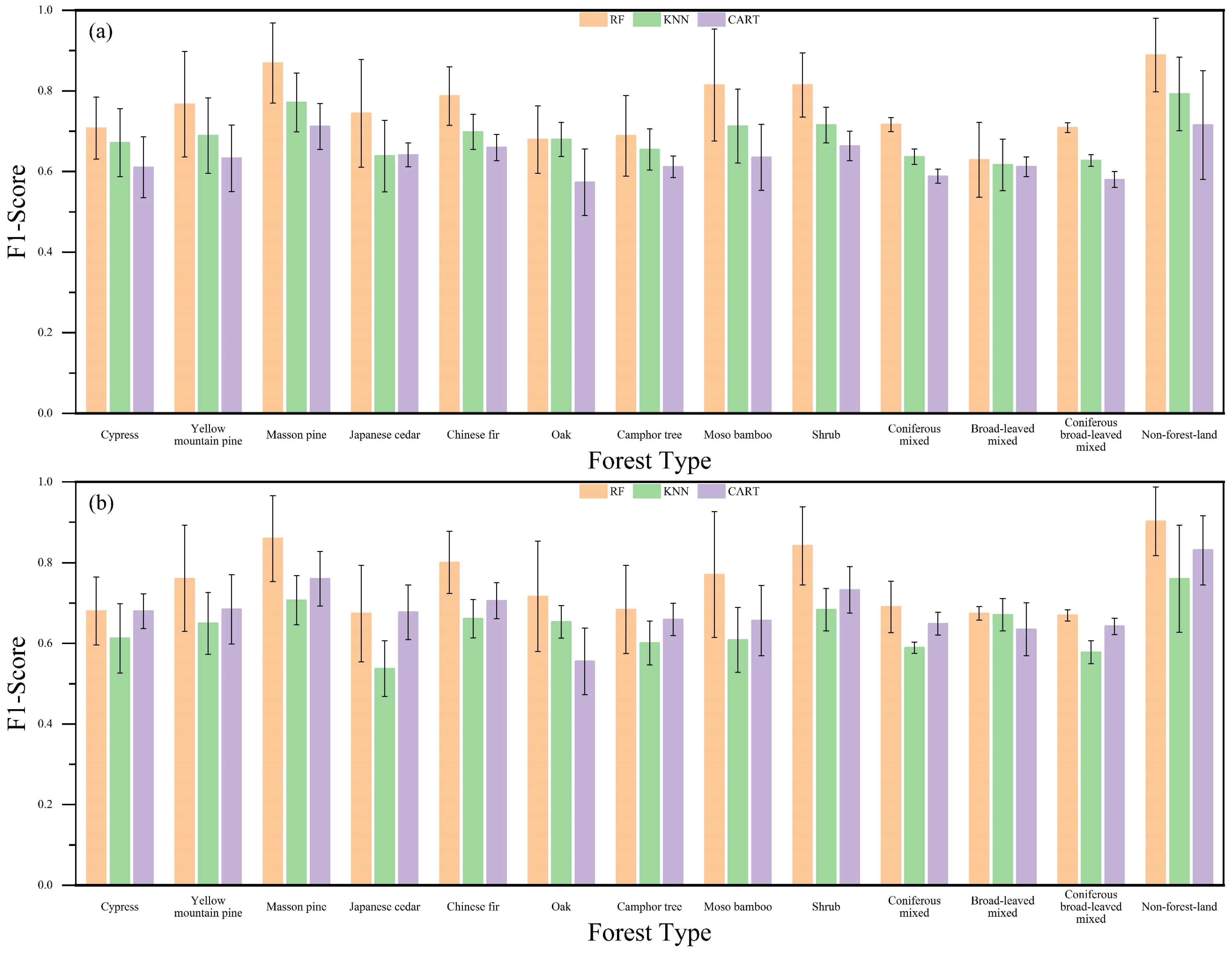
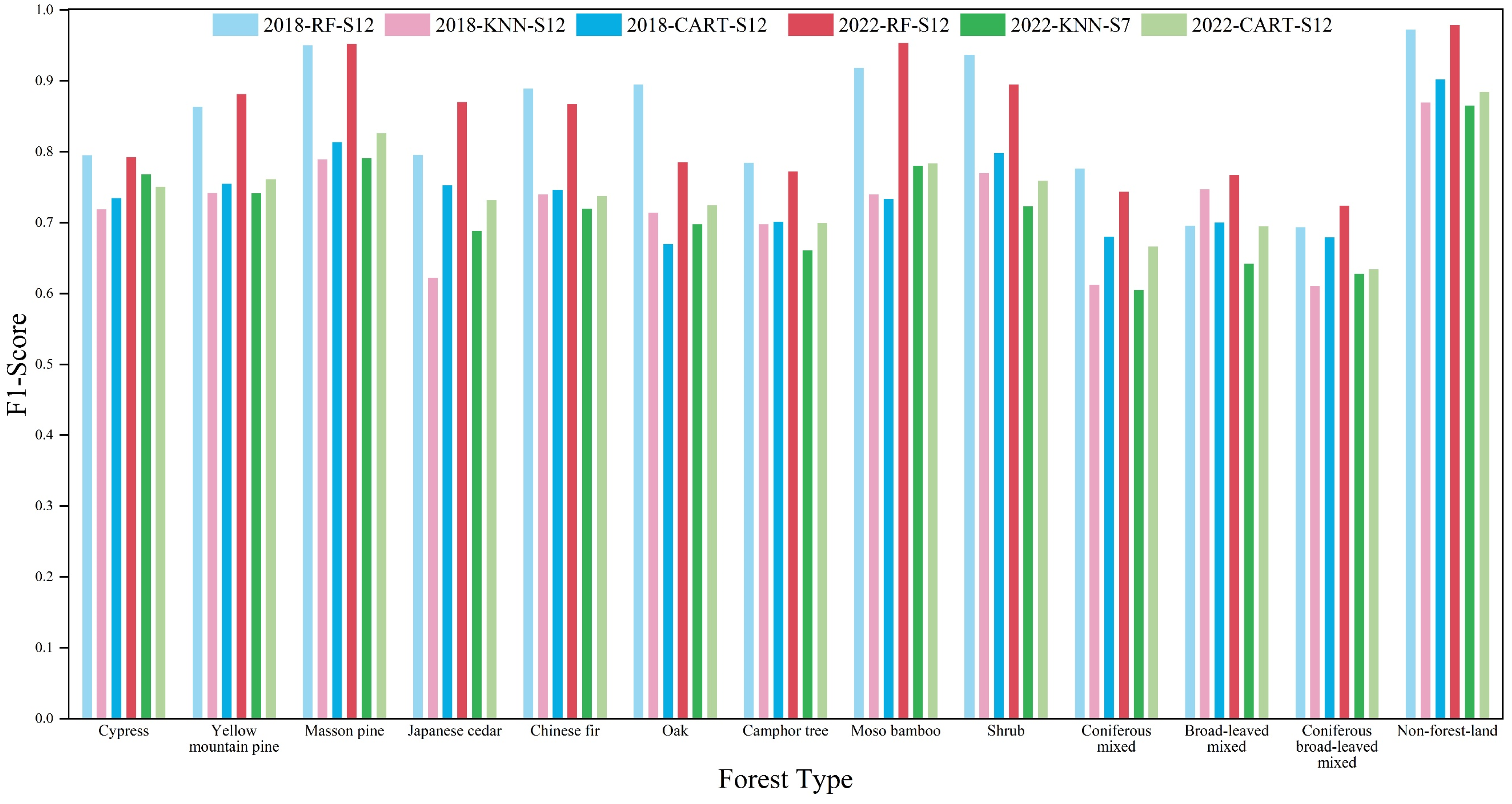
3.2. Classification Accuracy Assessment
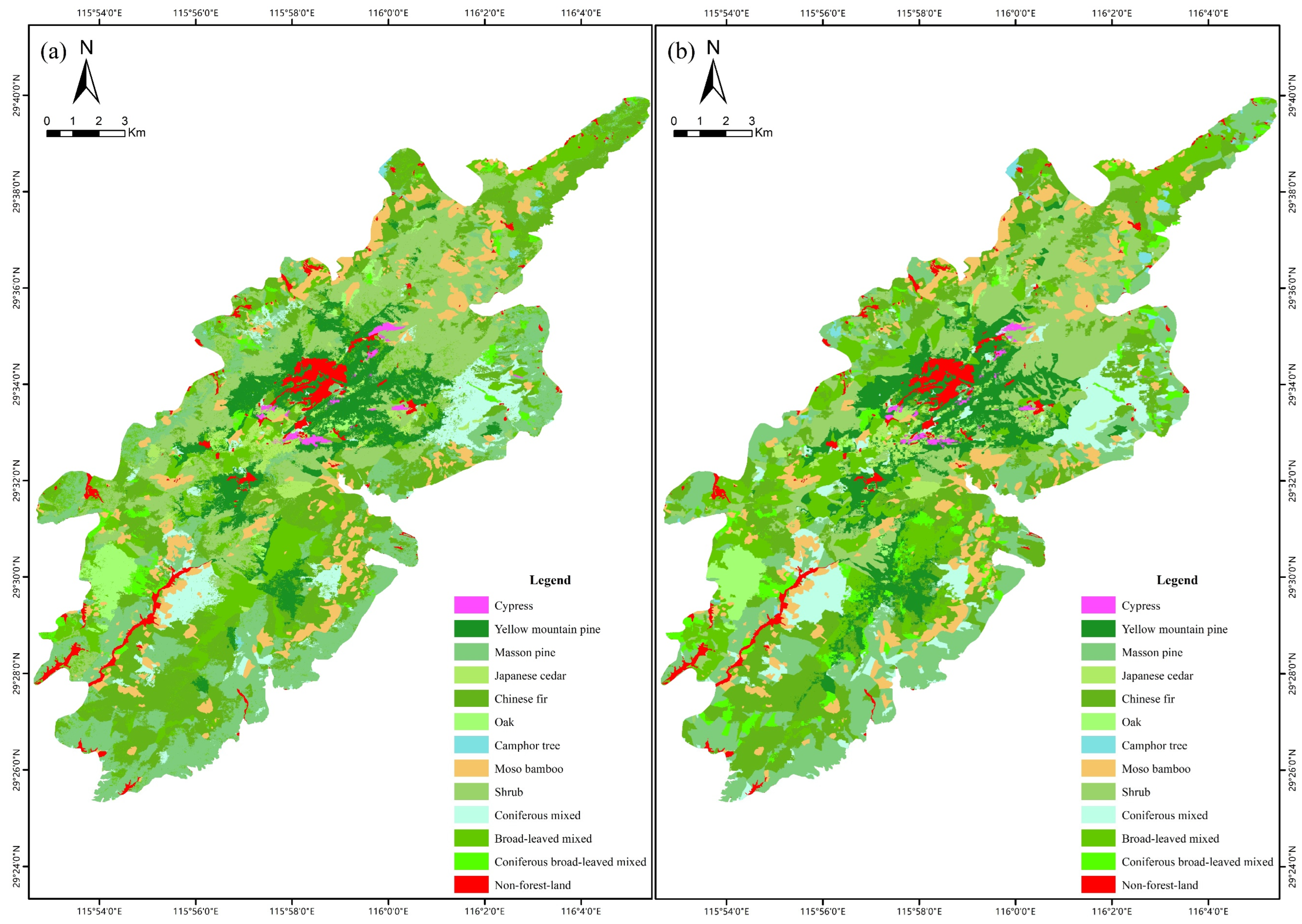
3.3. Tree Species Classification Results
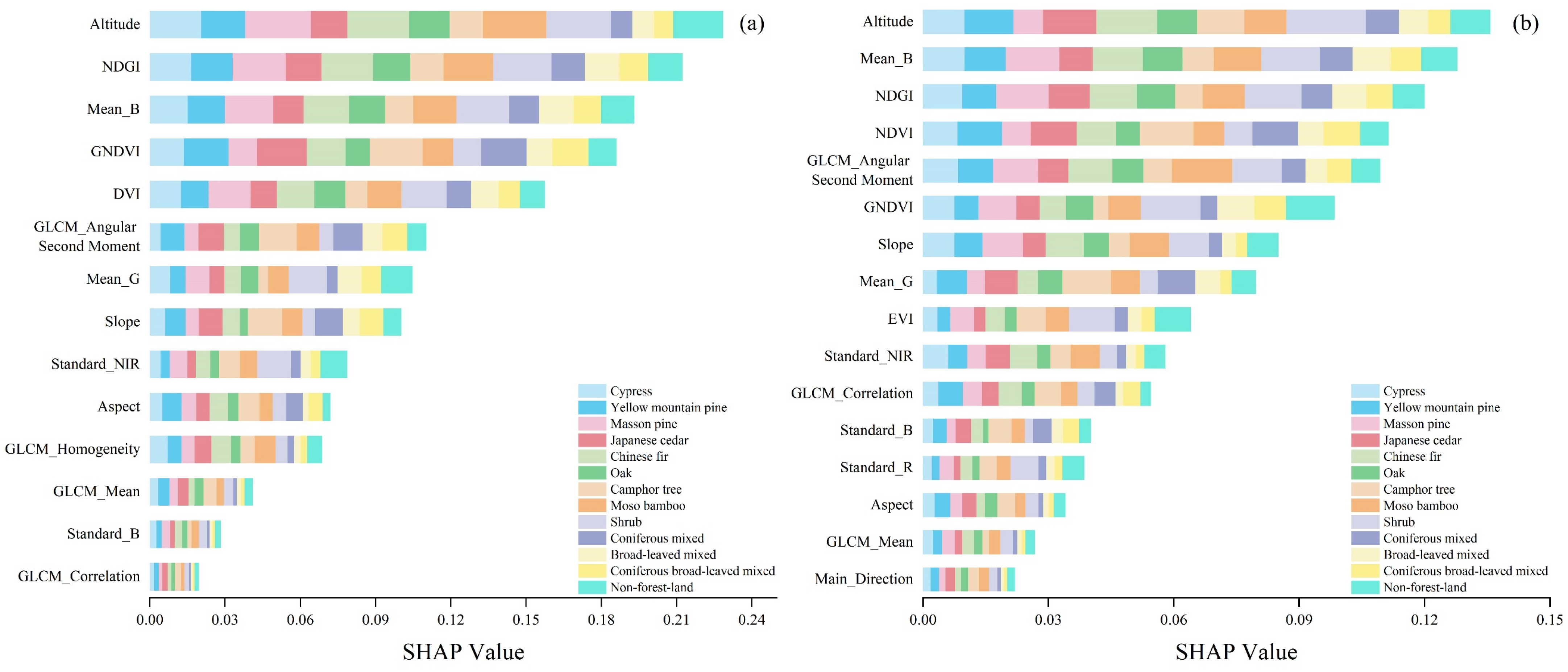
3.4. Feature Importance
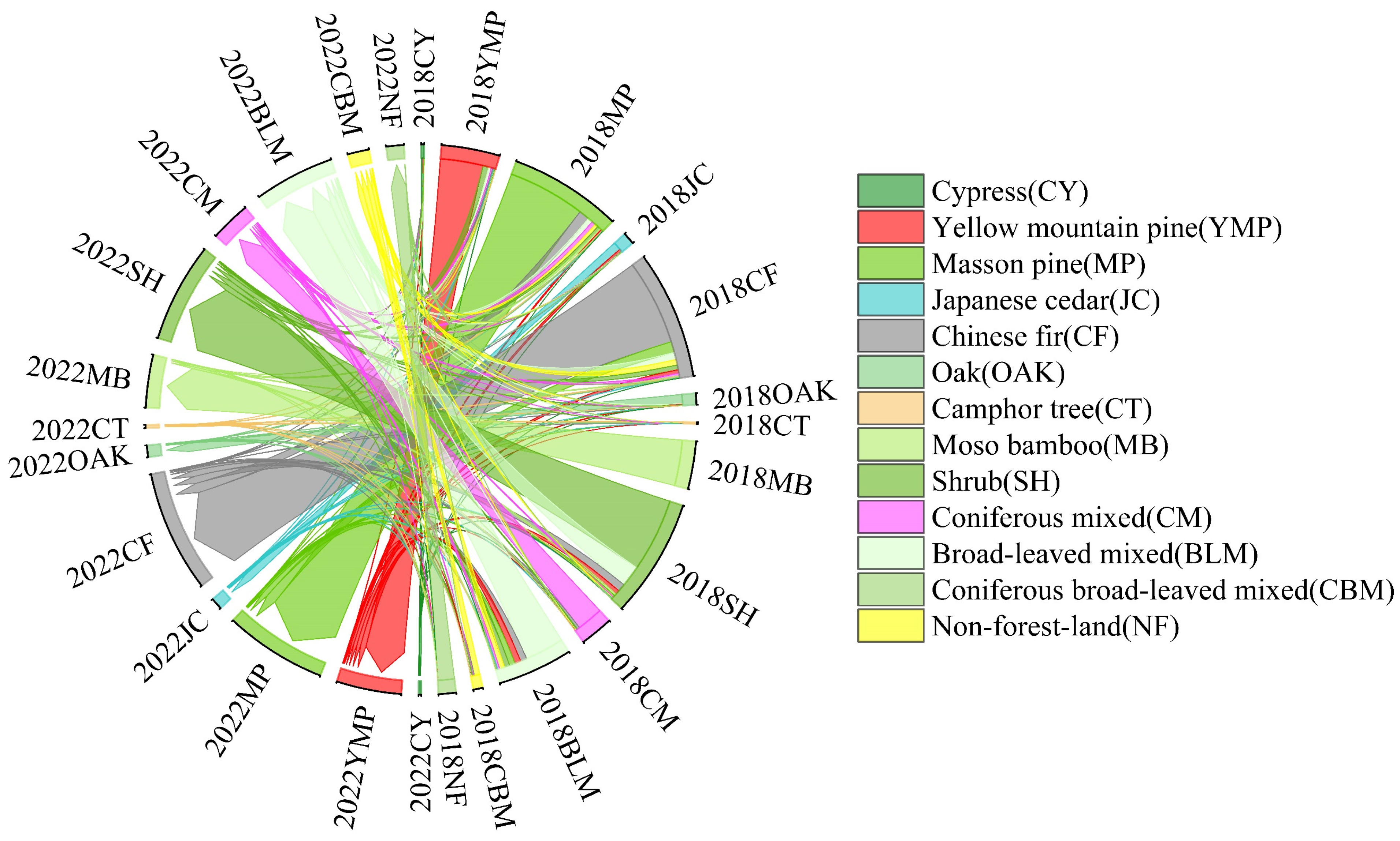
3.5. Changes in Forest Type from 2018 to 2022
4. Discussion
4.1. Comparison of Machine Learning Algorithms
4.2. Comparison of Feature Combination Schemes
4.3. Importance of Topographic Features in Classification
4.4. F1-Score Assessment and Dynamic Change Analysis
4.5. Limitations and Future Research Perspectives
5. Conclusions
Supplementary Materials
Author Contributions
Funding
Data Availability Statement
Acknowledgments
Conflicts of Interest
References
- Romijn, E.; Lantican, C.B.; Herold, M.; Lindquist, E.; Ochieng, R.; Wijaya, A.; Murdiyarso, D.; Verchot, L. Assessing Change in National Forest Monitoring Capacities of 99 Tropical Countries. For. Ecol. Manag. 2015, 352, 109–123. [Google Scholar] [CrossRef]
- Torabzadeh, H.; Leiterer, R.; Hueni, A.; Schaepman, M.E.; Morsdorf, F. Tree Species Classification in a Temperate Mixed Forest Using a Combination of Imaging Spectroscopy and Airborne Laser Scanning. Agric. For. Meteorol. 2019, 279, 107744. [Google Scholar] [CrossRef]
- Crabbe, R.A.; Lamb, D.; Edwards, C. Discrimination of Species Composition Types of a Grazed Pasture Landscape Using Sentinel-1 and Sentinel-2 Data. Int. J. Appl. Earth Obs. Geoinf. 2020, 84, 101978. [Google Scholar] [CrossRef]
- Lei, Z.; Li, H.; Zhao, J.; Jing, L.; Tang, Y.; Wang, H. Individual Tree Species Classification Based on a Hierarchical Convolutional Neural Network and Multitemporal Google Earth Images. Remote Sens. 2022, 14, 5124. [Google Scholar] [CrossRef]
- Wang, M.; Zheng, Y.; Huang, C.; Meng, R.; Pang, Y.; Jia, W.; Zhou, J.; Huang, Z.; Fang, L.; Zhao, F. Assessing Landsat-8 and Sentinel-2 Spectral-Temporal Features for Mapping Tree Species of Northern Plantation Forests in Heilongjiang Province, China. For. Ecosyst. 2022, 9, 100032. [Google Scholar] [CrossRef]
- Shi, Y.; Wang, T.; Skidmore, A.K.; Heurich, M. Improving LiDAR-Based Tree Species Mapping in Central European Mixed Forests Using Multi-Temporal Digital Aerial Colour-Infrared Photographs. Int. J. Appl. Earth Obs. Geoinf. 2020, 84, 101970. [Google Scholar] [CrossRef]
- Cilek, A.; Berberoglu, S.; Donmez, C.; Sahingoz, M. The Use of Regression Tree Method for Sentinel-2 Satellite Data to Mapping Percent Tree Cover in Different Forest Types. Environ. Sci. Pollut. Res. 2022, 29, 23665–23676. [Google Scholar] [CrossRef]
- Becker, A.; Russo, S.; Puliti, S.; Lang, N.; Schindler, K.; Wegner, J.D. Country-Wide Retrieval of Forest Structure from Optical and SAR Satellite Imagery with Deep Ensembles. ISPRS J. Photogramm. Remote Sens. 2023, 195, 269–286. [Google Scholar] [CrossRef]
- Ganivet, E.; Bloomberg, M. Towards Rapid Assessments of Tree Species Diversity and Structure in Fragmented Tropical Forests: A Review of Perspectives Offered by Remotely-Sensed and Field-Based Data. Forest Ecol. Manag. 2019, 432, 40–53. [Google Scholar] [CrossRef]
- Wang, R.; Gamon, J.A. Remote Sensing of Terrestrial Plant Biodiversity. Remote Sens. Environ. 2019, 231, 111218. [Google Scholar] [CrossRef]
- Reddy, C.S.; Kurian, A.; Srivastava, G.; Singhal, J.; Varghese, A.O.; Padalia, H.; Ayyappan, N.; Rajashekar, G.; Jha, C.S.; Rao, P.V.N. Remote Sensing Enabled Essential Biodiversity Variables for Biodiversity Assessment and Monitoring: Technological Advancement and Potentials. Biodivers. Conserv. 2021, 30, 1–14. [Google Scholar] [CrossRef]
- Axelsson, A.; Lindberg, E.; Reese, H.; Olsson, H. Tree Species Classification Using Sentinel-2 Imagery and Bayesian Inference. Int. J. Appl. Earth Obs. Geoinf. 2021, 100, 102318. [Google Scholar] [CrossRef]
- Bolyn, C.; Lejeune, P.; Michez, A.; Latte, N. Mapping Tree Species Proportions from Satellite Imagery Using Spectral-Spatial Deep Learning. Remote Sens. Environ. 2022, 280, 113205. [Google Scholar] [CrossRef]
- Mäyrä, J.; Keski-Saari, S.; Kivinen, S.; Tanhuanpää, T.; Hurskainen, P.; Kullberg, P.; Poikolainen, L.; Viinikka, A.; Tuominen, S.; Kumpula, T.; et al. Tree Species Classification from Airborne Hyperspectral and LiDAR Data Using 3D Convolutional Neural Networks. Remote Sens. Environ. 2021, 256, 112322. [Google Scholar] [CrossRef]
- Matese, A.; Toscano, P.; Di Gennaro, S.F.; Genesio, L.; Vaccari, F.P.; Primicerio, J.; Belli, C.; Zaldei, A.; Bianconi, R.; Gioli, B. Intercomparison of UAV, Aircraft and Satellite Remote Sensing Platforms for Precision Viticulture. Remote Sens. 2015, 7, 2971–2990. [Google Scholar] [CrossRef]
- Sprott, A.H.; Piwowar, J.M. How to Recognize Different Types of Trees from Quite a Long Way Away: Combining UAV and Spaceborne Imagery for Stand-Level Tree Species Identification. J. Unmanned Veh. Syst. 2021, 9, 166–181. [Google Scholar] [CrossRef]
- Chen, X.; Shen, X.; Cao, L. Tree Species Classification in Subtropical Natural Forests Using High-Resolution UAV RGB and SuperView-1 Multispectral Imageries Based on Deep Learning Network Approaches: A Case Study within the Baima Snow Mountain National Nature Reserve, China. Remote Sens. 2023, 15, 2697. [Google Scholar] [CrossRef]
- Hidayat, S.; Matsuoka, M.; Baja, S.; Rampisela, D.A. Object-Based Image Analysis for Sago Palm Classification: The Most Important Features from High-Resolution Satellite Imagery. Remote Sens. 2018, 10, 1319. [Google Scholar] [CrossRef]
- Rajbhandari, S.; Aryal, J.; Osborn, J.; Lucieer, A.; Musk, R. Leveraging Machine Learning to Extend Ontology-Driven Geographic Object-Based Image Analysis (O-GEOBIA): A Case Study in Forest-Type Mapping. Remote Sens. 2019, 11, 503. [Google Scholar] [CrossRef]
- Feizizadeh, B.; Kazemi Garajeh, M.; Blaschke, T.; Lakes, T. An Object Based Image Analysis Applied for Volcanic and Glacial Landforms Mapping in Sahand Mountain, Iran. Catena 2021, 198, 105073. [Google Scholar] [CrossRef]
- Qu, L.; Chen, Z.; Li, M.; Zhi, J.; Wang, H. Accuracy Improvements to Pixel-Based and Object-Based LULC Classification with Auxiliary Datasets from Google Earth Engine. Remote Sens. 2021, 13, 453. [Google Scholar] [CrossRef]
- Deur, M.; Gasparovic, M.; Balenovic, I. An Evaluation of Pixel- and Object-Based Tree Species Classification in Mixed Deciduous Forests Using Pansharpened Very High Spatial Resolution Satellite Imagery. Remote Sens. 2021, 13, 1868. [Google Scholar] [CrossRef]
- Li, T.; Johansen, K.; McCabe, M.F. A Machine Learning Approach for Identifying and Delineating Agricultural Fields and Their Multi-Temporal Dynamics Using Three Decades of Landsat Data. ISPRS J. Photogramm. Remote Sens. 2022, 186, 83–101. [Google Scholar] [CrossRef]
- Zeferino, L.B.; Tavares de Souza, L.F.; do Amaral, C.H.; Fernandes Filho, E.I.; de Oliveira, T.S. Does Environmental Data Increase the Accuracy of Land Use and Land Cover Classification? Int. J. Appl. Earth Obs. Geoinf. 2020, 91, 102128. [Google Scholar] [CrossRef]
- Oreti, L.; Giuliarelli, D.; Tomao, A.; Barbati, A. Object Oriented Classification for Mapping Mixed and Pure Forest Stands Using Very-High Resolution Imagery. Remote Sens. 2021, 13, 2508. [Google Scholar] [CrossRef]
- Wang, M.; Liu, Z.; Baig, M.H.A.; Wang, Y.; Li, Y.; Chen, Y. Mapping Sugarcane in Complex Landscapes by Integrating Multi-Temporal Sentinel-2 Images and Machine Learning Algorithms. Land Use Policy 2019, 88, 104190. [Google Scholar] [CrossRef]
- Fang, J.; Guo, Z.; Hu, H.; Kato, T.; Muraoka, H.; Son, Y. Forest Biomass Carbon Sinks in East Asia, with Special Reference to the Relative Contributions of Forest Expansion and Forest Growth. Glob. Change Biol. 2014, 20, 2019–2030. [Google Scholar] [CrossRef]
- Xiang, X.-G.; Mi, X.-C.; Zhou, H.-L.; Jianwu, L.; Chung, S.-W.; Li, D.-Z.; Huang, W.-C.; Jin, W.-T.; Li, Z.-Y.; Huang, L.-Q.; et al. Biogeographical Diversification of Mainland Asian Dendrobium (Orchidaceae) and Its Implications for the Historical Dynamics of Evergreen Broad-Leaved Forests. J. Biogeogr. 2016, 43, 1310–1323. [Google Scholar] [CrossRef]
- Xu, Z.; Shen, X.; Cao, L.; Coops, N.C.; Goodbody, T.R.H.; Zhong, T.; Zhao, W.; Sun, Q.; Ba, S.; Zhang, Z.; et al. Tree Species Classification Using UAS-Based Digital Aerial Photogrammetry Point Clouds and Multispectral Imageries in Subtropical Natural Forests. Int. J. Appl. Earth Obs. Geoinf. 2020, 92, 102173. [Google Scholar] [CrossRef]
- Richter, R.; Reu, B.; Wirth, C.; Doktor, D.; Vohland, M. The Use of Airborne Hyperspectral Data for Tree Species Classification in a Species-Rich Central European Forest Area. Int. J. Appl. Earth Obs. Geoinf. 2016, 52, 464–474. [Google Scholar] [CrossRef]
- Fassnacht, F.E.; Latifi, H.; Stereńczak, K.; Modzelewska, A.; Lefsky, M.; Waser, L.T.; Straub, C.; Ghosh, A. Review of Studies on Tree Species Classification from Remotely Sensed Data. Remote Sens. Environ. 2016, 186, 64–87. [Google Scholar] [CrossRef]
- Liu, Y.; Zhang, R.; Lin, C.-F.; Zhang, Z.; Zhang, R.; Shang, K.; Zhao, M.; Huang, J.; Wang, X.; Li, Y.; et al. Remote Sensing of Subtropical Tree Diversity: The Underappreciated Roles of the Practical Definition of Forest Canopy and Phenological Variation. For. Ecosyst. 2023, 10, 100122. [Google Scholar] [CrossRef]
- Sothe, C.; Dalponte, M.; de Almeida, C.M.; Schimalski, M.B.; Lima, C.L.; Liesenberg, V.; Miyoshi, G.T.; Garcia Tommaselli, A.M. Tree Species Classification in a Highly Diverse Subtropical Forest Integrating UAV-Based Photogrammetric Point Cloud and Hyperspectral Data. Remote Sens. 2019, 11, 1338. [Google Scholar] [CrossRef]
- Qin, H.; Zhou, W.; Yao, Y.; Wang, W. Individual Tree Segmentation and Tree Species Classification in Subtropical Broadleaf Forests Using UAV-Based LiDAR, Hyperspectral, and Ultrahigh-Resolution RGB Data. Remote Sens. Environ. 2022, 280, 113143. [Google Scholar] [CrossRef]
- Wu, Q.; Zhong, R.; Zhao, W.; Song, K.; Du, L. Land-Cover Classification Using GF-2 Images and Airborne Lidar Data Based on Random Forest. Int. J. Remote Sens. 2019, 40, 2410–2426. [Google Scholar] [CrossRef]
- Li, D.; Ke, Y.; Gong, H.; Li, X. Object-Based Urban Tree Species Classification Using Bi-Temporal WorldView-2 and WorldView-3 Images. Remote Sens. 2015, 7, 16917–16937. [Google Scholar] [CrossRef]
- Jia, K.; Liu, J.; Tu, Y.; Li, Q.; Sun, Z.; Wei, X.; Yao, Y.; Zhang, X. Land Use and Land Cover Classification Using Chinese GF-2 Multispectral Data in a Region of the North China Plain. Front Earth Sci. 2019, 13, 327–335. [Google Scholar] [CrossRef]
- Drǎguţ, L.; Tiede, D.; Levick, S.R. ESP: A Tool to Estimate Scale Parameter for Multiresolution Image Segmentation of Remotely Sensed Data. Int. J. Geogr. Inf. Sci. 2010, 24, 859–871. [Google Scholar] [CrossRef]
- Woodcock, C.E.; Strahler, A.H. The Factor of Scale in Remote Sensing. Remote Sens. Environ. 1987, 21, 311–332. [Google Scholar] [CrossRef]
- Ferreira, M.P.; Zortea, M.; Zanotta, D.C.; Shimabukuro, Y.E.; de Souza Filho, C.R. Mapping Tree Species in Tropical Seasonal Semi-Deciduous Forests with Hyperspectral and Multispectral Data. Remote Sens. Environ. 2016, 179, 66–78. [Google Scholar] [CrossRef]
- Clark, M.L.; Kilham, N.E. Mapping of Land Cover in Northern California with Simulated Hyperspectral Satellite Imagery. ISPRS J. Photogramm. Remote Sens. 2016, 119, 228–245. [Google Scholar] [CrossRef]
- Wood, E.M.; Pidgeon, A.M.; Radeloff, V.C.; Keuler, N.S. Image Texture as a Remotely Sensed Measure of Vegetation Structure. Remote Sens. Environ. 2012, 121, 516–526. [Google Scholar] [CrossRef]
- Olofsson, P.; Foody, G.M.; Herold, M.; Stehman, S.V.; Woodcock, C.E.; Wulder, M.A. Good Practices for Estimating Area and Assessing Accuracy of Land Change. Remote Sens. Environ. 2014, 148, 42–57. [Google Scholar] [CrossRef]
- Dong, C.; Zhao, G.; Meng, Y.; Li, B.; Peng, B. The Effect of Topographic Correction on Forest Tree Species Classification Accuracy. Remote Sens. 2020, 12, 787. [Google Scholar] [CrossRef]
- Zhao, Q.; Jia, S.; Li, Y. Hyperspectral Remote Sensing Image Classification Based on Tighter Random Projection with Minimal Intra-Class Variance Algorithm. Pattern Recognit. 2021, 111, 107635. [Google Scholar] [CrossRef]
- Qin, H.; Wang, W.; Yao, Y.; Qian, Y.; Xiong, X.; Zhou, W. First Experience with Zhuhai-1 Hyperspectral Data for Urban Dominant Tree Species Classification in Shenzhen, China. Remote Sens. 2023, 15, 3179. [Google Scholar] [CrossRef]
- Pal, M. Random Forest Classifier for Remote Sensing Classification. Int. J. Remote Sens. 2005, 26, 217–222. [Google Scholar] [CrossRef]
- Haapanen, R.; Ek, A.R.; Bauer, M.E.; Finley, A.O. Delineation of Forest/Nonforest Land Use Classes Using Nearest Neighbor Methods. Remote Sens. Environ. 2004, 89, 265–271. [Google Scholar] [CrossRef]
- Tu, Y.; Lang, W.; Yu, L.; Li, Y.; Jiang, J.; Qin, Y.; Wu, J.; Chen, T.; Xu, B. Improved Mapping Results of 10 m Resolution Land Cover Classification in Guangdong, China Using Multisource Remote Sensing Data with Google Earth Engine. IEEE J. Sel. Topics Appl. Earth Observ. Remote Sens. 2020, 13, 5384–5397. [Google Scholar] [CrossRef]
- Luo, C.; Qi, B.; Liu, H.; Guo, D.; Lu, L.; Fu, Q.; Shao, Y. Using Time Series Sentinel-1 Images for Object-Oriented Crop Classification in Google Earth Engine. Remote Sens. 2021, 13, 561. [Google Scholar] [CrossRef]
- Chen, C.; Jing, L.; Li, H.; Tang, Y.; Chen, F. Individual Tree Species Identification Based on a Combination of Deep Learning and Traditional Features. Remote Sens. 2023, 15, 2301. [Google Scholar] [CrossRef]
- Baumann, M.; Ozdogan, M.; Kuemmerle, T.; Wendland, K.J.; Esipova, E.; Radeloff, V.C. Using the Landsat Record to Detect Forest-Cover Changes during and after the Collapse of the Soviet Union in the Temperate Zone of European Russia. Remote Sens. Environ. 2012, 124, 174–184. [Google Scholar] [CrossRef]
- Lundberg, S.M.; Lee, S.-I. A Unified Approach to Interpreting Model Predictions. In Advances in Neural Information Processing Systems 30, Proceedings of the 31st International Conference on Neural Information Processing Systems, Long Beach, CA, USA, 4–9 December 2017; Guyon, I., Von Luxburg, U., Bengio, S., Wallach, H., Fergus, R., Vishwanathan, S., Garnett, R., Eds.; Curran Associates Inc.: Red Hook, NY, USA, 2017; pp. 4768–4777. [Google Scholar]
- Shapley, L.S. A Value for N-Person Games; RAND Corporation: Santa Monica, CA, USA, 1952. [Google Scholar]
- Dikshit, A.; Pradhan, B. Interpretable and Explainable AI (XAI) Model for Spatial Drought Prediction. Sci. Total Environ. 2021, 801, 149797. [Google Scholar] [CrossRef]
- Rina, S.; Ying, H.; Shan, Y.; Du, W.; Liu, Y.; Li, R.; Deng, D. Application of Machine Learning to Tree Species Classification Using Active and Passive Remote Sensing: A Case Study of the Duraer Forestry Zone. Remote Sens. 2023, 15, 2596. [Google Scholar] [CrossRef]
- Luo, H.; Li, M.; Dai, S.; Li, H.; Li, Y.; Hu, Y.; Zheng, Q.; Yu, X.; Fang, J. Combinations of Feature Selection and Machine Learning Algorithms for Object-Oriented Betel Palms and Mango Plantations Classification Based on Gaofen-2 Imagery. Remote Sens. 2022, 14, 1757. [Google Scholar] [CrossRef]
- Melville, B.; Lucieer, A.; Aryal, J. Object-Based Random Forest Classification of Landsat ETM plus and WorldView-2 Satellite Imagery for Mapping Lowland Native Grassland Communities in Tasmania, Australia. Int. J. Appl. Earth Obs. Geoinf. 2018, 66, 46–55. [Google Scholar] [CrossRef]
- Wurm, M.; Taubenböck, H.; Weigand, M.; Schmitt, A. Slum Mapping in Polarimetric SAR Data Using Spatial Features. Remote Sens. Environ. 2017, 194, 190–204. [Google Scholar] [CrossRef]
- Liu, L.; Coops, N.C.; Aven, N.W.; Pang, Y. Mapping Urban Tree Species Using Integrated Airborne Hyperspectral and LiDAR Remote Sensing Data. Remote Sens. Environ. 2017, 200, 170–182. [Google Scholar] [CrossRef]
- Hurskainen, P.; Adhikari, H.; Siljander, M.; Pellikka, P.K.E.; Hemp, A. Auxiliary Datasets Improve Accuracy of Object-Based Land Use/Land Cover Classification in Heterogeneous Savanna Landscapes. Remote Sens. Environ. 2019, 233, 111354. [Google Scholar] [CrossRef]
- Hua, L.; Zhang, X.; Chen, X.; Yin, K.; Tang, L. A Feature-Based Approach of Decision Tree Classification to Map Time Series Urban Land Use and Land Cover with Landsat 5 TM and Landsat 8 OLI in a Coastal City, China. ISPRS Int. J. Geoinf. 2017, 6, 331. [Google Scholar] [CrossRef]
- Guo, Q.; Zhang, J.; Guo, S.; Ye, Z.; Deng, H.; Hou, X.; Zhang, H. Urban Tree Classification Based on Object-Oriented Approach and Random Forest Algorithm Using Unmanned Aerial Vehicle (UAV) Multispectral Imagery. Remote Sens. 2022, 14, 3885. [Google Scholar] [CrossRef]
- Fu, B.; Liu, M.; He, H.; Lan, F.; He, X.; Liu, L.; Huang, L.; Fan, D.; Zhao, M.; Jia, Z. Comparison of Optimized Object-Based RF-DT Algorithm and SegNet Algorithm for Classifying Karst Wetland Vegetation Communities Using Ultra-High Spatial Resolution UAV Data. Int. J. Appl. Earth Obs. Geoinf. 2021, 104, 102553. [Google Scholar] [CrossRef]
- Garg, R.; Kumar, A.; Prateek, M.; Pandey, K.; Kumar, S. Land Cover Classification of Spaceborne Multifrequency SAR and Optical Multispectral Data Using Machine Learning. Adv. Space Res. 2022, 69, 1726–1742. [Google Scholar] [CrossRef]
- Hościło, A.; Lewandowska, A. Mapping Forest Type and Tree Species on a Regional Scale Using Multi-Temporal Sentinel-2 Data. Remote Sens. 2019, 11, 929. [Google Scholar] [CrossRef]
- Vorovencii, I.; Dincă, L.; Crișan, V.; Postolache, R.-G.; Codrean, C.-L.; Cătălin, C.; Greșiță, C.I.; Chima, S.; Gavrilescu, I. Local-Scale Mapping of Tree Species in a Lower Mountain Area Using Sentinel-1 and -2 Multitemporal Images, Vegetation Indices, and Topographic Information. Front. For. Glob. Change 2023, 6, 1220253. [Google Scholar] [CrossRef]
- He, G.; Zhang, Z.; Zhu, Q.; Wang, W.; Peng, W.; Cai, Y. Estimating Carbon Sequestration Potential of Forest and Its Influencing Factors at Fine Spatial-Scales: A Case Study of Lushan City in Southern China. Int. J. Environ. Res. Public Health 2022, 19, 9184. [Google Scholar] [CrossRef]
- Oke, O.A.; Thompson, K.A. Distribution Models for Mountain Plant Species: The Value of Elevation. Ecol. Model. 2015, 301, 72–77. [Google Scholar] [CrossRef]
- Zhao, F.; Wu, X.; Wang, S. Object-Oriented Vegetation Classification Method Based on UAV and Satellite Image Fusion. Procedia Comput. Sci. 2020, 174, 609–615. [Google Scholar] [CrossRef]
- Reichstein, M.; Camps-Valls, G.; Stevens, B.; Jung, M.; Denzler, J.; Carvalhais, N.; Prabhat, F. Deep Learning and Process Understanding for Data-Driven Earth System Science. Nature 2019, 566, 195–204. [Google Scholar] [CrossRef]
- Zhang, C.; Pan, X.; Li, H.; Gardiner, A.; Sargent, I.; Hare, J.; Atkinson, P.M. A Hybrid MLP-CNN Classifier for Very Fine Resolution Remotely Sensed Image Classification. ISPRS J. Photogramm. Remote Sens. 2018, 140, 133–144. [Google Scholar] [CrossRef]
- Onishi, M.; Watanabe, S.; Nakashima, T.; Ise, T. Practicality and Robustness of Tree Species Identification Using UAV RGB Image and Deep Learning in Temperate Forest in Japan. Remote Sens. 2022, 14, 1710. [Google Scholar] [CrossRef]
- Zhou, R.; Yang, C.; Li, E.; Cai, X.; Yang, J.; Xia, Y. Object-Based Wetland Vegetation Classification Using Multi-Feature Selection of Unoccupied Aerial Vehicle RGB Imagery. Remote Sens. 2021, 13, 4910. [Google Scholar] [CrossRef]


| Land Use/Land Cover Types | Forest Types | Dominant Tree Species | Scientific Name |
|---|---|---|---|
| Forest land | Coniferous forest | Cypress | Cupressus funebris |
| Yellow mountain pine | Pinus huangshanensis | ||
| Masson pine | Pinus massoniana | ||
| Japanese cedar | Cryptomeria japonica | ||
| Chinese fir | Cunninghamia lanceolata | ||
| Broad-leaved forest | Oak | Quercus | |
| Camphor tree | Cinnamomum camphora | ||
| Bamboo forest | Moso bamboo | Phyllostachys edulis | |
| Shrub | - | - | |
| Coniferous mixed | - | - | |
| Broad-leaved mixed | - | - | |
| Coniferous broad-leaved mixed | - | - | |
| Non-forest land | Including cropland, bare land, construction land, and waters | ||
| Id | Type | Acronym | Scientific Name | Total | Training | Verification |
|---|---|---|---|---|---|---|
| 1 | Cypress | CY | Cupressus funebris | 250 | 175 | 75 |
| 2 | Yellow mountain pine | YMP | Pinus huangshanensis | 290 | 203 | 87 |
| 3 | Masson pine | MP | Pinus massoniana | 620 | 434 | 186 |
| 4 | Japanese cedar | JC | Cryptomeria japonica | 350 | 245 | 105 |
| 5 | Chinese fir | CF | Cunninghamia lanceolata | 560 | 392 | 168 |
| 6 | Oak | OAK | Quercus | 230 | 161 | 69 |
| 7 | Camphor tree | CT | Cinnamomum camphora | 240 | 168 | 72 |
| 8 | Moso bamboo | MB | Phyllostachys edulis | 400 | 280 | 120 |
| 9 | Shrub | SH | - | 500 | 350 | 150 |
| 10 | Coniferous mixed | CM | - | 310 | 217 | 93 |
| 11 | Broad-leaved mixed | BLM | - | 360 | 252 | 108 |
| 12 | Coniferous broad-leaved mixed | CBM | - | 330 | 231 | 99 |
| 13 | Non-forest-land | NF | - | 240 | 168 | 72 |
| Total | 4680 | 3276 | 1404 | |||
| Type | Feature | Description | Number |
|---|---|---|---|
| SPEC | Mean_B, G, R, NIR; Standard_B, G, R, NIR; Brightness. | Mean and standard deviation of reflectance and overall brightness of the GF-2 image in four bands: blue, green, red, and near-infrared. | 9 |
| INDE | NDVI, GNDVI, NDWI, NDGI, SAVI, DVI, EVI, RVI, GRVI, OSAVI, IPVI | The formula is shown in Table S1. | 11 |
| GLCM | Homogeneity, Correlation, Dissimilarity, Entropy, Angular Second Moment, Mean, Standard Deviation, Contrast. | Extraction of texture features using grayscale covariance matrix (GLCM). | 8 |
| GEOM | Length/Width, Asymmetry, Border Index, Compactness, Density, Main Direction, Rectangular Fit, Roundness, Shape Index. | The shape of the main evaluation object, based on the shape of the image object, is calculated from the pixels that make up the image object. | 9 |
| TOPO | Altitude, Slope, Aspect. | Altitude, Slope, Aspect Extracted from DEM data using spatial analysis tools in Arcgis 10.6 software. | 3 |
| ID of Scheme | Feature Combination | SPEC | INDE | GLCM | GEOM | TOPO | Total |
|---|---|---|---|---|---|---|---|
| S1 | SPEC | 9 | 9 | ||||
| S2 | INDE | 11 | 11 | ||||
| S3 | GLCM | 8 | 8 | ||||
| S4 | GEOM | 9 | 9 | ||||
| S5 | TOPO | 3 | 3 | ||||
| S6 | SPEC + INDE + GLCM + GEOM | 9 | 11 | 8 | 9 | 37 | |
| S7 | SPEC + INDE + GLCM + TOPO | 9 | 11 | 8 | 3 | 31 | |
| S8 | SPEC + INDE + GEOM + TOPO | 9 | 11 | 9 | 3 | 32 | |
| S9 | SPEC + GLCM + GEOM + TOPO | 9 | 8 | 9 | 3 | 29 | |
| S10 | INDE + GLCM + GEOM + TOPO | 8 | 9 | 3 | 20 | ||
| S11 | All | 9 | 11 | 8 | 9 | 3 | 40 |
| S12 | 2018_All_Wrapper | 4 | 3 | 4 | 3 | 14 | |
| 2022_All_Wrapper | 5 | 4 | 3 | 1 | 3 | 16 |
Disclaimer/Publisher’s Note: The statements, opinions and data contained in all publications are solely those of the individual author(s) and contributor(s) and not of MDPI and/or the editor(s). MDPI and/or the editor(s) disclaim responsibility for any injury to people or property resulting from any ideas, methods, instructions or products referred to in the content. |
© 2024 by the authors. Licensee MDPI, Basel, Switzerland. This article is an open access article distributed under the terms and conditions of the Creative Commons Attribution (CC BY) license (https://creativecommons.org/licenses/by/4.0/).
Share and Cite
He, G.; Li, S.; Huang, C.; Xu, S.; Li, Y.; Jiang, Z.; Xu, J.; Yang, F.; Wan, W.; Zou, Q.; et al. Comparison of Algorithms and Optimal Feature Combinations for Identifying Forest Type in Subtropical Forests Using GF-2 and UAV Multispectral Images. Forests 2024, 15, 1327. https://doi.org/10.3390/f15081327
He G, Li S, Huang C, Xu S, Li Y, Jiang Z, Xu J, Yang F, Wan W, Zou Q, et al. Comparison of Algorithms and Optimal Feature Combinations for Identifying Forest Type in Subtropical Forests Using GF-2 and UAV Multispectral Images. Forests. 2024; 15(8):1327. https://doi.org/10.3390/f15081327
Chicago/Turabian StyleHe, Guowei, Shun Li, Chao Huang, Shi Xu, Yang Li, Zijun Jiang, Jiashuang Xu, Funian Yang, Wei Wan, Qin Zou, and et al. 2024. "Comparison of Algorithms and Optimal Feature Combinations for Identifying Forest Type in Subtropical Forests Using GF-2 and UAV Multispectral Images" Forests 15, no. 8: 1327. https://doi.org/10.3390/f15081327
APA StyleHe, G., Li, S., Huang, C., Xu, S., Li, Y., Jiang, Z., Xu, J., Yang, F., Wan, W., Zou, Q., Zhang, M., Feng, Y., & He, G. (2024). Comparison of Algorithms and Optimal Feature Combinations for Identifying Forest Type in Subtropical Forests Using GF-2 and UAV Multispectral Images. Forests, 15(8), 1327. https://doi.org/10.3390/f15081327