
A Review: Tree Species Classification Based on Remote Sensing Data and Classic Deep Learning-Based Methods


Abstract
1. Introduction and Review Approach
1.1. Significance of Tree Species Information
1.2. Objectives
- Analysis of the literature on the classification of tree species by remote sensing in the past 25 years and quantifying general trends.
- A statistical analysis of the unimodal and multimodal remote sensing data in TS classification is conducted by reading and analyzing each paper. Subsequently, the remote sensing data trends are studied.
- Provide a detailed overview of the classic deep learning-based methods that solely utilize convolutional neural networks (CNN) for classifying tree species.
- Identification of research gaps in TS classification and description of future trends in TS classification using remote sensing data.
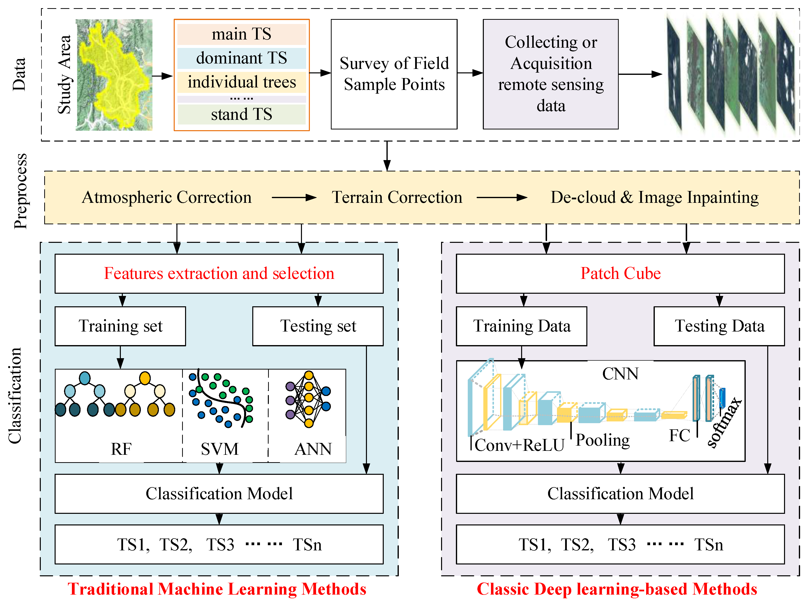
1.3. Review Approach
- TS classification objects must be group tree species OR main tree species OR dominant tree species OR stand tree species OR individual tree.
- The research must report on the corresponding specific remote sensing data.
- The research must report the tree species classification methods.
- The research must report the assessment of the classification result.
2. Trends in Tree Species Classification
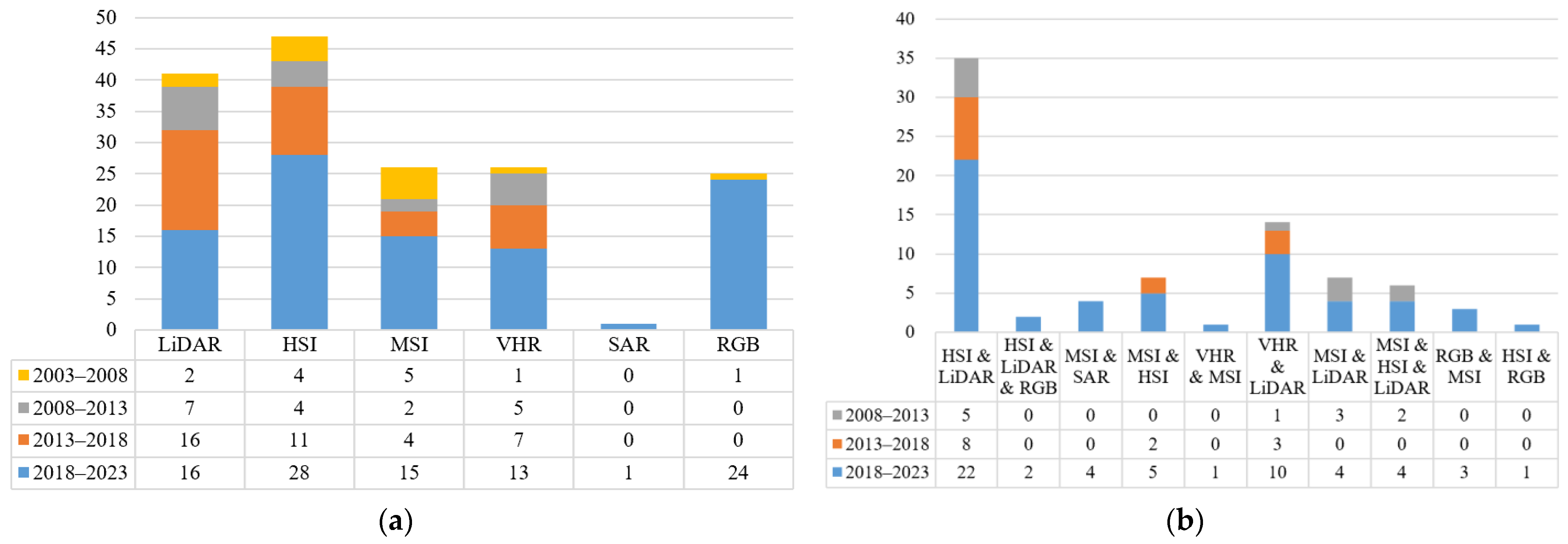
2.1. Remote Sensing Data for TS Classification
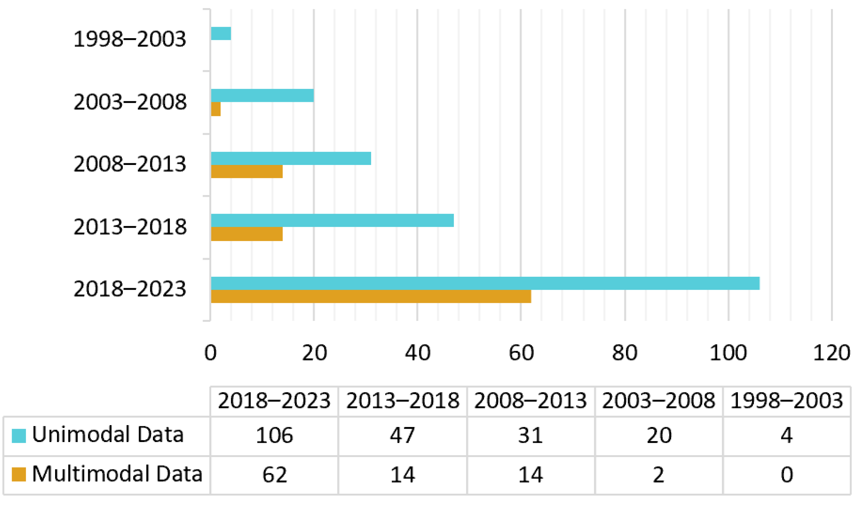
2.2. Literature Trends in Remote Sensing Data
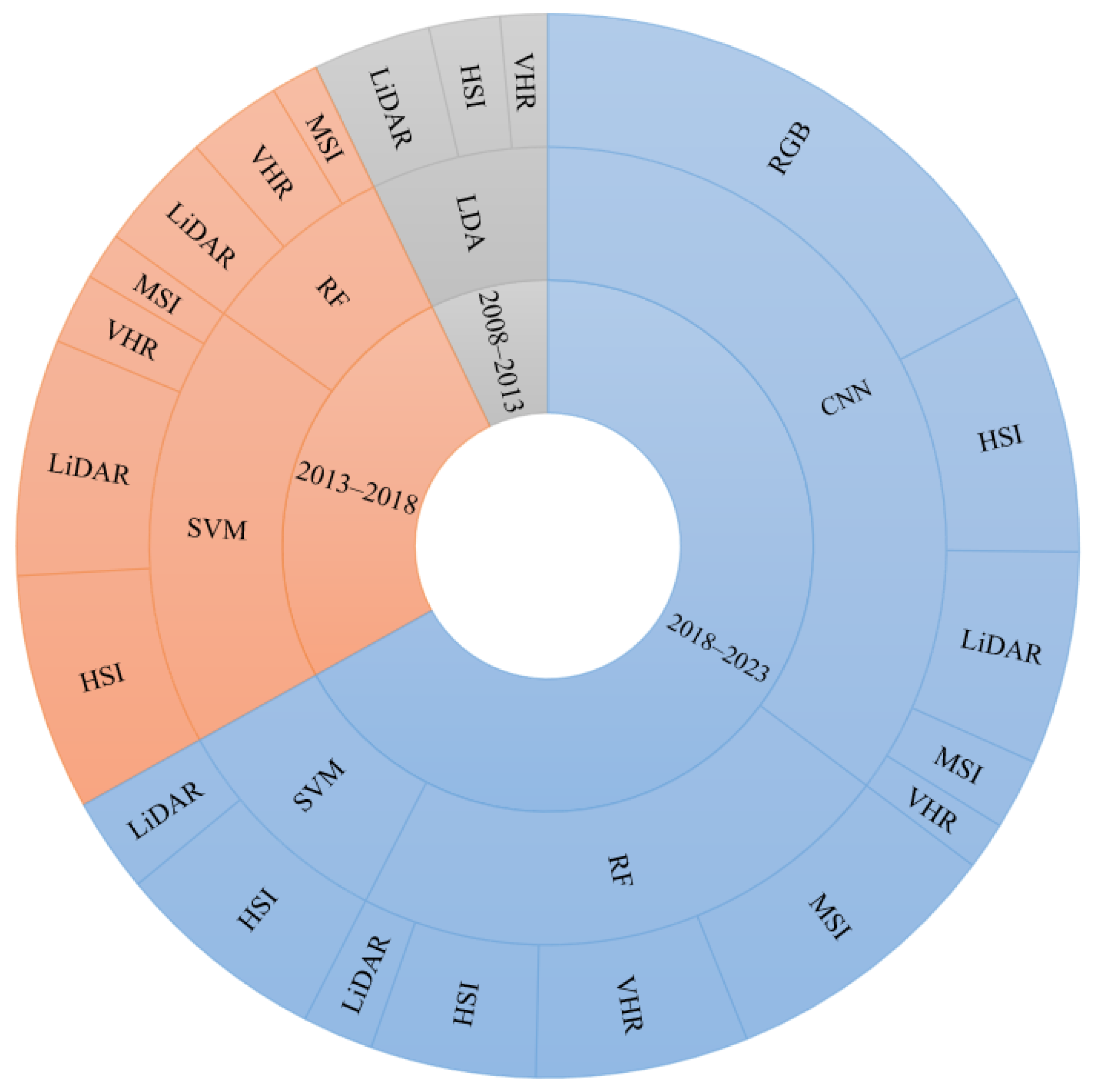
2.3. Methods for TS Classification
2.3.1. Classification Methods of Unimodal Remote Sensing Data
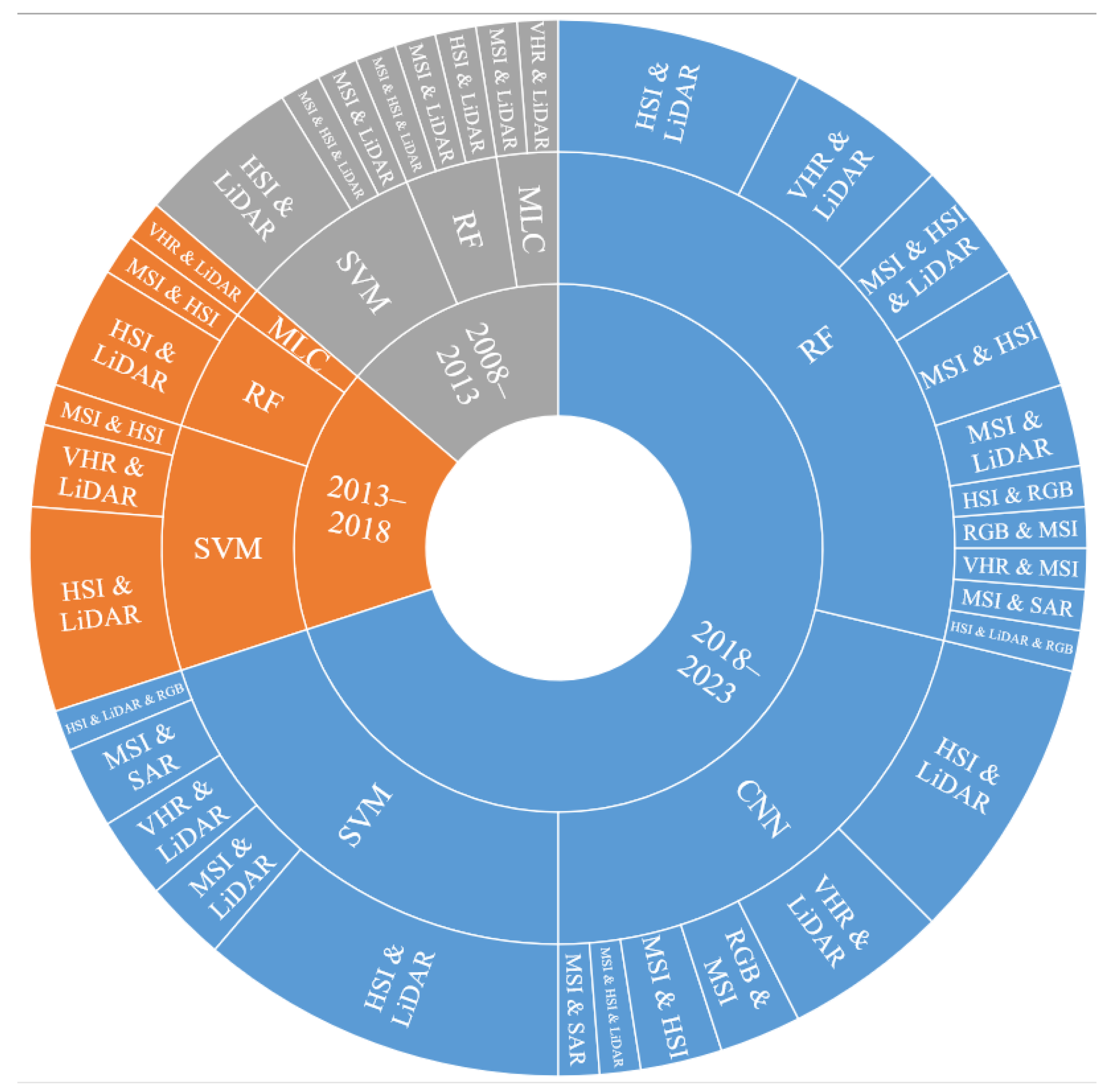
2.3.2. Classification Methods of Multimodal Remote Sensing Data
2.4. Literature Trends in TS Classification Methods
3. Literature Review on Classic Deep Learning-Based Methods
3.1. Patch Size
3.2. Reference Data
3.3. TS Classification Scales
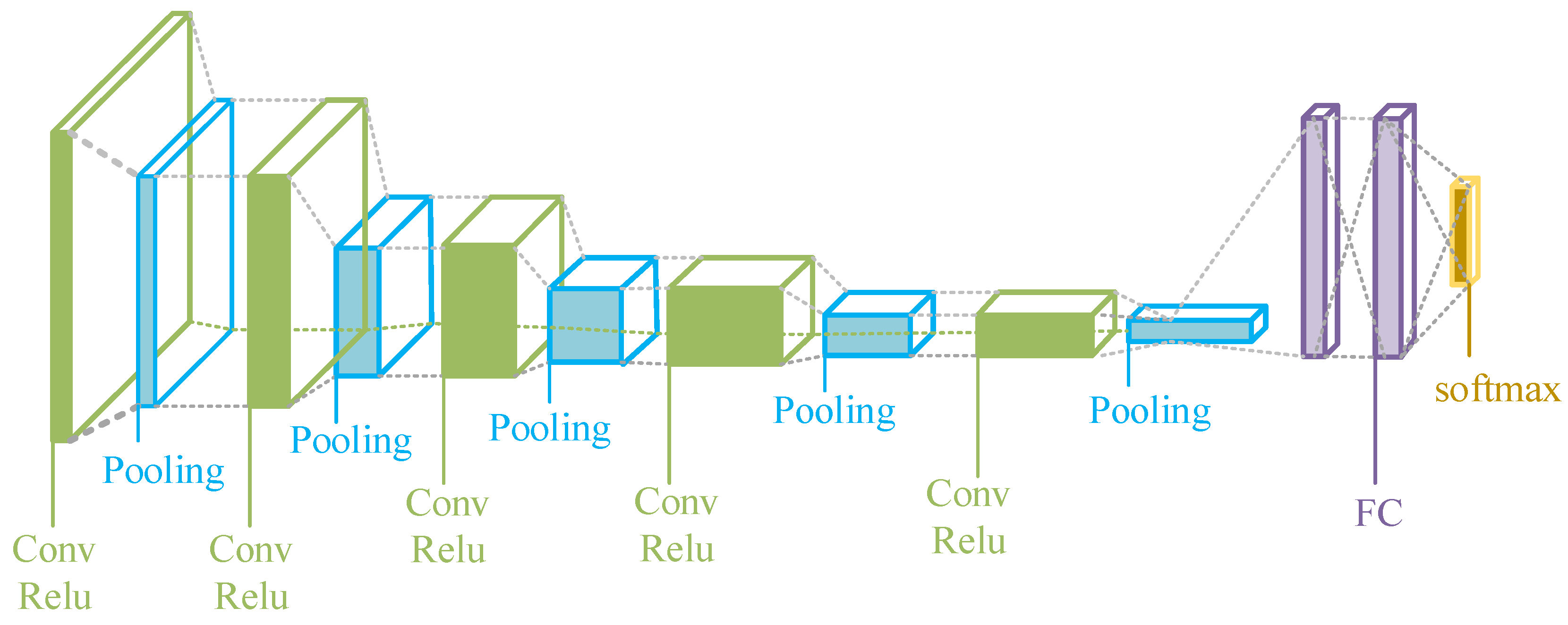
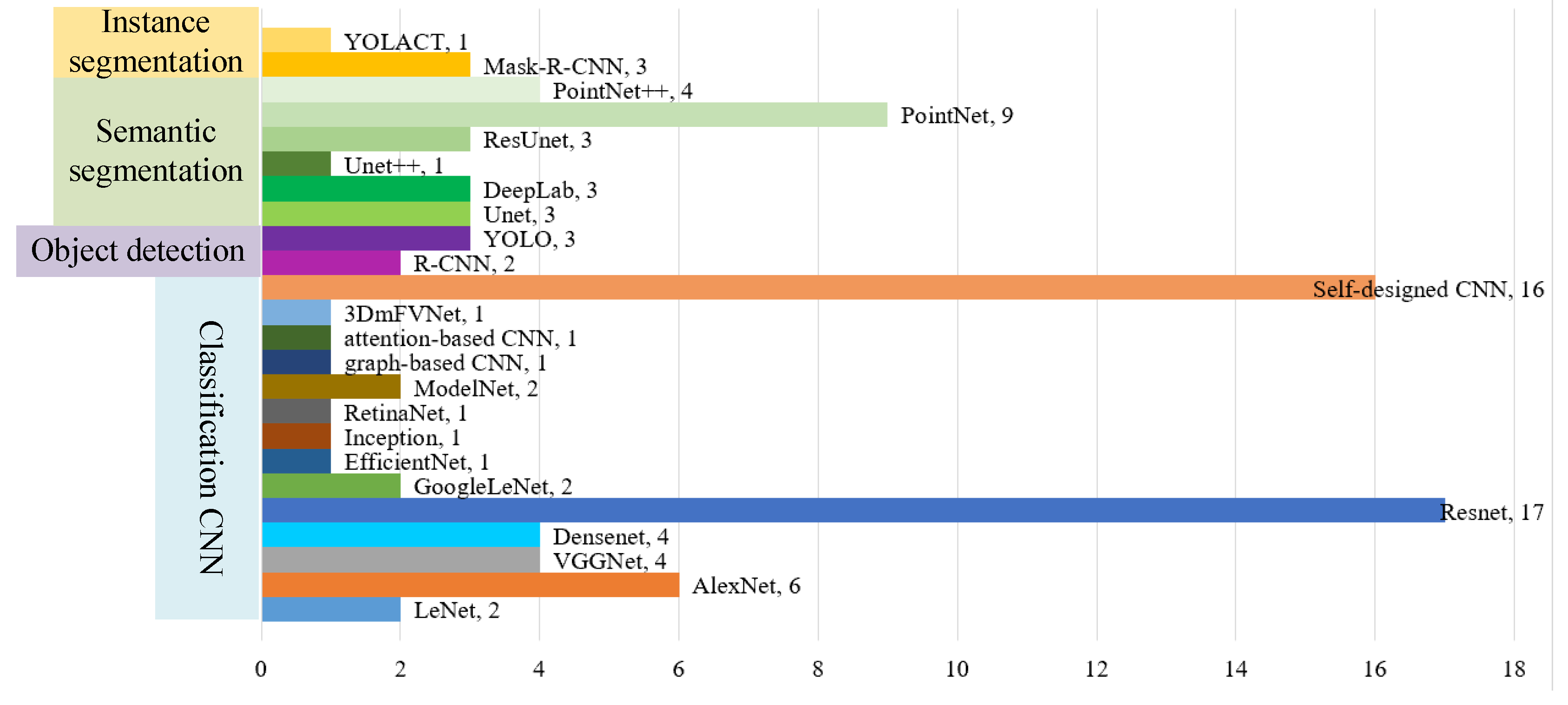
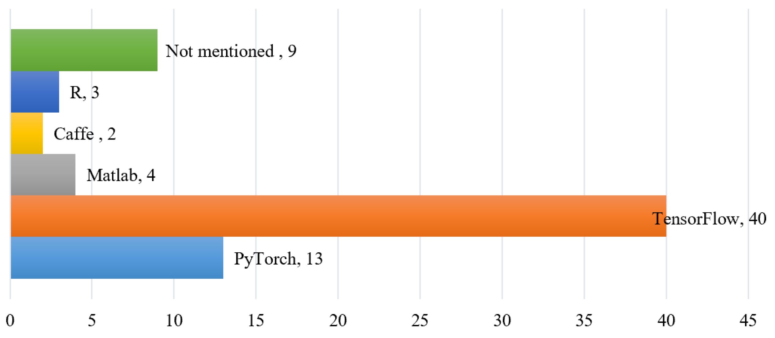
3.4. CNN Architectures and Application
3.4.1. CNN from the Functional Perspective
3.4.2. CNN from the Input Data Perspective
3.4.3. Multimodal Remote Sensing Data Fusion
3.5. CNN Model Assessment and Operational Framework in TS Classification
3.5.1. CNN Model Assessment
3.5.2. CNN Model Operational Framework
4. Limitations and Future Work
4.1. Data Fusion
- Spatially sharpened data fusion method
- Feature-level data fusion method
- Spatiotemporal Data Fusion method
4.2. Phenology Information
4.3. Data Label
4.4. Patch Size
4.5. CNN Model Optimization Approaches
4.6. Outlook on New Technologies
5. Conclusions
- From the number of publications, tree species classification has become a hot topic in current research. From the unimodal and multimodal remote sensor data utilization, the main unimodal data for TS classification were HSI, LiDAR, RGB, and VHR, and the most used multimodal data were HIS and LiDAR.
- According to the literature analysis of TS classification methods, the most commonly used classifiers for remote sensing data, whether unimodal or multimodal, were CNN, RF, and SVM. Therefore, this article summarizes the process of remote sensing TS classification and condenses the two major current TS classification methods: traditional machine learning methods and classic deep learning-based methods.
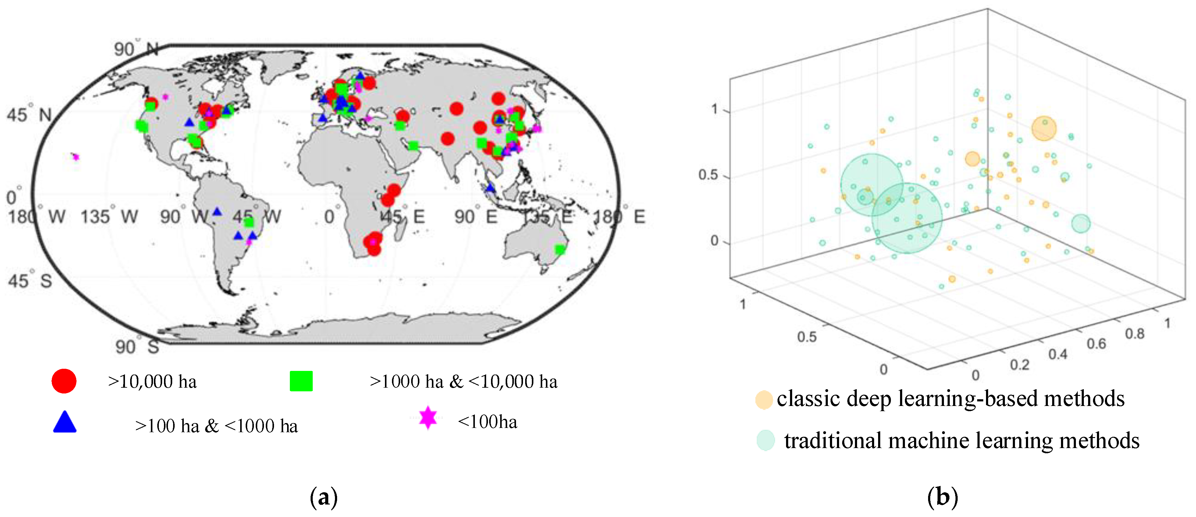
- Traditional machine learning methods are utilized for tree classification in large study areas, while classic deep learning-based methods are employed for tree classification in small study areas. The classic deep learning-based methods are beginning to be used for tree classification in large study areas.
- The classic deep learning-based methods for TS classification are reviewed in detail in terms of patch size, reference data, TS classification scales, CNN architectures and applications, CNN operational framework, and CNN model assessment.
- Six limitations and future work are discussed below, and suggestions are made to overcome potential issues in the future. (a) Data fusion. A spatial-temporal fusion algorithm and real fusion algorithm of multimodal remote sensing data can be applied to TS classification, or the existing multimodal remote sensing data fusion algorithm should be improved to study TS classification. (b) Phenology information. A feature or method was created with an explicit physical meaning of the phenological variation used to improve the accuracy of TS classification. (c) Data label. Label production is very labor-intensive, and field surveys for TS classification labeling are time-consuming and laborious. It is recommended that field surveys with weakly supervised and semi-supervised learning for labeling are combined. (d ) Patch size. When utilizing remote sensing data for tree species classification, it is important to consider the optimal ground sampling density and spatial unit. Specifically, it is necessary to determine the spatial unit for obtaining tree species information and the optimal ground sampling density for deriving such information using a given sensor. Patch size has not been studied enough, and it may depend on the spatial resolution of the classification target, the distribution and size of the forest stand area, or other factors, which is an interesting problem to study. (e) CNN model optimization. To improve the generalization ability of CNN models and alleviate the overfitting problem, some strategies were given. (f) New technologies, such as transformer and multimodal-based methods will be applied to TS classification shortly.
Author Contributions
Funding
Data Availability Statement
Conflicts of Interest
Abbreviations
| AHI | Advanced Himawari imager |
| ASTER | Advanced spaceborne thermal emission and reflection radiometer |
| Bi-LSTM | Bidirectional long short-term memory |
| CASI | Compact airborne spectrographic imager |
| CNN | Convolutional neural network |
| Conv | The convolutional layer |
| DBMF | Double-branch multi-source fusion |
| FC | The fully connected layer |
| HSI | Hyperspectral image |
| IoU | Intersection over union |
| LDA | Linear discriminant analysis |
| LiDAR | Light detection and ranging |
| MLC | Maximum likelihood classifiers |
| MSI | Multispectral image |
| OA | Overall accuracy |
| PA | Producer’s accuracy |
| RF | Random forest |
| RGB | The red, green, and blue image |
| RNN | Recurrent neural network |
| SAR | Active remote sensing synthetic aperture radar |
| SPOT | Satellite Pour l’Observation de la Terre HighResolution Visible |
| SVM | Support vector machine |
| TS | Tree species |
| UA | User’s accuracy |
| UAV | Unmanned aerial vehicle |
| VHR | Very high spatial resolution |
| ViTs | Vision transformers |
| WOS | Web of Science |
References
- Fang, F.; McNeil, B.E.; Warner, T.A.; Maxwell, A.E.; Dahle, G.A.; Eutsler, E.; Li, J. Discriminating Tree Species at Different Taxonomic Levels Using Multi-Temporal WorldView-3 Imagery in Washington DC, USA. Remote Sens. Environ. 2020, 246, 111811. [Google Scholar] [CrossRef]
- Sun, Y.; Huang, J.; Ao, Z.; Lao, D.; Xin, Q.; Fang, F.; McNeil, B.E.; Warner, T.A.; Maxwell, A.E.; Dahle, G.A.; et al. Deep Learning Approaches for the Mapping of Tree Species Diversity in a Tropical Wetland Using Airborne LiDAR and High-Spatial-Resolution Remote Sensing Images. Forests 2019, 10, 1047. [Google Scholar] [CrossRef]
- Arasumani, M.; Bunyan, M.; Robin, V.V. Opportunities and Challenges in Using Remote Sensing for Invasive Tree Species Management, and in the Identification of Restoration Sites in Tropical Montane Grasslands. J. Environ. Manag. 2021, 280, 111759. [Google Scholar] [CrossRef] [PubMed]
- Chambers, D.; Périé, C.; Casajus, N.; De Blois, S. Challenges in Modelling the Abundance of 105 Tree Species in Eastern North America Using Climate, Edaphic, and Topographic Variables. For. Ecol. Manag. 2013, 291, 20–29. [Google Scholar] [CrossRef]
- Marconi, S.; Weinstein, B.G.; Zou, S.; Bohlman, S.A.; Zare, A.; Singh, A.; Stewart, D.; Harmon, I.; Steinkraus, A.; White, E.P. Continental-Scale Hyperspectral Tree Species Classification in the United States National Ecological Observatory Network. Remote Sens. Environ. 2022, 282, 113264. [Google Scholar] [CrossRef]
- Casas, Á.; García, M.; Siegel, R.B.; Koltunov, A.; Ramírez, C.; Ustin, S. Burned Forest Characterization at Single-Tree Level with Airborne Laser Scanning for Assessing Wildlife Habitat. Remote Sens. Environ. 2016, 175, 231–241. [Google Scholar] [CrossRef]
- Abdollahnejad, A.; Panagiotidis, D. Tree Species Classification and Health Status Assessment for a Mixed Broadleaf-Conifer Forest with UAS Multispectral Imaging. Remote Sens. 2020, 12, 3722. [Google Scholar] [CrossRef]
- Potter, K.M.; Escanferla, M.E.; Jetton, R.M.; Man, G.; Crane, B.S. Prioritizing the Conservation Needs of United States Tree Species: Evaluating Vulnerability to Forest Insect and Disease Threats. Glob. Ecol. Conserv. 2019, 18, e00622. [Google Scholar] [CrossRef]
- Felbermeier, B.; Hahn, A.; Schneider, T. Study on User Requirements for Remote Sensing Applications in Forestry. In Proceedings of the ISPRS Symposium Technical Commission VII, Vienna, Austria, 5–7 July 2010; pp. 210–212. [Google Scholar]
- Fassnacht, F.E.; Latifi, H.; Stereńczak, K.; Modzelewska, A.; Lefsky, M.; Waser, L.T.; Straub, C.; Ghosh, A. Review of Studies on Tree Species Classification from Remotely Sensed Data. Remote Sens. Environ. 2016, 186, 64–87. [Google Scholar] [CrossRef]
- Jensen, R.R.; Hardin, P.J.; Hardin, A.J. Classification of Urban Tree Species Using Hyperspectral Imagery. Geocarto Int. 2012, 27, 443–458. [Google Scholar] [CrossRef]
- Pu, R. Mapping Tree Species Using Advanced Remote Sensing Technologies: A State-of-the-Art Review and Perspective. J. Remote Sens. 2021, 2021, 1–26. [Google Scholar] [CrossRef]
- Qin, H.; Zhou, W.; Yao, Y.; Wang, W. Individual Tree Segmentation and Tree Species Classification in Subtropical Broadleaf Forests Using UAV-Based LiDAR, Hyperspectral, and Ultrahigh-Resolution RGB Data. Remote Sens. Environ. 2022, 280, 113143. [Google Scholar] [CrossRef]
- Quan, Y.; Li, M.; Hao, Y.; Liu, J.; Wang, B. Tree Species Classification in a Typical Natural Secondary Forest Using UAV-Borne LiDAR and Hyperspectral Data. GISci. Remote Sens. 2023, 60, 2171706. [Google Scholar] [CrossRef]
- Cao, J.; Liu, K.; Zhuo, L.; Liu, L.; Zhu, Y.; Peng, L. Combining UAV-Based Hyperspectral and LiDAR Data for Mangrove Species Classification Using the Rotation Forest Algorithm. Int. J. Appl. Earth Obs. Geoinf. 2021, 102, 102414. [Google Scholar] [CrossRef]
- Sothe, C.; La Rosa, L.E.C.; De Almeida, C.M.; Gonsamo, A.; Schimalski, M.B.; Castro, J.D.B.; Feitosa, R.Q.; Dalponte, M.; Lima, C.L.; Liesenberg, V.; et al. Evaluating a Convolutional Neural Network for Feature Extraction and Tree Species Classification Using Uav-Hyperspectral Images. ISPRS Ann. Photogramm. Remote Sens. Spat. Inf. Sci. 2020, 5, 193–199. [Google Scholar] [CrossRef]
- dos Santos, A.A.; Marcato Junior, J.; Araújo, M.S.; Di Martini, D.R.; Tetila, E.C.; Siqueira, H.L.; Aoki, C.; Eltner, A.; Matsubara, E.T.; Pistori, H.; et al. Assessment of CNN-Based Methods for Individual Tree Detection on Images Captured by RGB Cameras Attached to UAVS. Sensors 2019, 19, 3595. [Google Scholar] [CrossRef]
- Hartling, S.; Sagan, V.; Maimaitijiang, M. Urban Tree Species Classification Using UAV-Based Multi-Sensor Data Fusion and Machine Learning. GISci. Remote Sens. 2021, 58, 1250–1275. [Google Scholar] [CrossRef]
- Onishi, M.; Ise, T. Explainable Identification and Mapping of Trees Using UAV RGB Image and Deep Learning. Sci. Rep. 2021, 11, 903. [Google Scholar] [CrossRef]
- Chen, X.; Shen, X.; Cao, L. Tree Species Classification in Subtropical Natural Forests Using High-Resolution UAV RGB and SuperView-1 Multispectral Imageries Based on Deep Learning Network Approaches: A Case Study within the Baima Snow Mountain National Nature Reserve, China. Remote Sens. 2023, 15, 2697. [Google Scholar] [CrossRef]
- Onishi, M.; Watanabe, S.; Nakashima, T.; Ise, T. Practicality and Robustness of Tree Species Identification Using UAV RGB Image and Deep Learning in Temperate Forest in Japan. Remote Sens. 2022, 14, 1710. [Google Scholar] [CrossRef]
- Zhang, C.; Xia, K.; Feng, H.; Yang, Y.; Du, X. Tree Species Classification Using Deep Learning and RGB Optical Images Obtained by an Unmanned Aerial Vehicle. J. For. Res. 2021, 32, 1879–1888. [Google Scholar] [CrossRef]
- Pu, R.; Landry, S.; Yu, Q. Assessing the Potential of Multi-Seasonal High-Resolution Pléiades Satellite Imagery for Mapping Urban Tree Species. Int. J. Appl. Earth Obs. Geoinf. 2018, 71, 144–158. [Google Scholar] [CrossRef]
- Asner, G.P.; Jones, M.O.; Martin, R.E.; Knapp, D.E.; Hughes, R.F. Remote Sensing of Native and Invasive Species in Hawaiian Forests. Remote Sens. Environ. 2008, 112, 1912–1926. [Google Scholar] [CrossRef] [PubMed]
- Fang, P.; Ou, G.; Li, R.; Wang, L.; Xu, W.; Dai, Q.; Huang, X. Regionalized Classification of Stand Tree Species in Mountainous Forests by Fusing Advanced Classifiers and Ecological Niche Model. GISci. Remote Sens. 2023, 60, 2211881. [Google Scholar] [CrossRef]
- Nasiri, V.; Beloiu, M.; Darvishsefat, A.A.; Griess, V.C.; Maftei, C.; Waser, L.T. Mapping Tree Species Composition in a Caspian Temperate Mixed Forest Based on Spectral-Temporal Metrics and Machine Learning. Int. J. Appl. Earth Obs. Geoinf. 2023, 116, 103154. [Google Scholar] [CrossRef]
- Guo, Q.; Zhang, J.; Guo, S.; Ye, Z.; Deng, H.; Hou, X.; Zhang, H. Urban Tree Classification Based on Object-Oriented Approach and Random Forest Algorithm Using Unmanned Aerial Vehicle (Uav) Multispectral Imagery. Remote Sens. 2022, 14, 3885. [Google Scholar] [CrossRef]
- Axelsson, A.; Lindberg, E.; Reese, H.; Olsson, H. Tree Species Classification Using Sentinel-2 Imagery and Bayesian Inference. Int. J. Appl. Earth Obs. Geoinf. 2021, 100, 102318. [Google Scholar] [CrossRef]
- Xi, Y.; Ren, C.; Tian, Q.; Ren, Y.; Dong, X.; Zhang, Z. Exploitation of Time Series Sentinel-2 Data and Different Machine Learning Algorithms for Detailed Tree Species Classification. IEEE J. Sel. Top. Appl. Earth Obs. Remote Sens. 2021, 14, 7589–7603. [Google Scholar] [CrossRef]
- Davis, C.H.; Wang, X. Planimetric Accuracy of Ikonos 1 m Panchromatic Orthoimage Products and Their Utility for Local Government GIS Basemap Applications. Int. J. Remote Sens. 2003, 24, 4267–4288. [Google Scholar] [CrossRef]
- Mora, B.; Wulder, M.A.; White, J.C. Identifying Leading Species Using Tree Crown Metrics Derived from Very High Spatial Resolution Imagery in a Boreal Forest Environment. Can. J. Remote Sens. 2010, 36, 332–344. [Google Scholar] [CrossRef]
- Van Deventer, H.; Cho, M.A.; Mutanga, O. Improving the Classification of Six Evergreen Subtropical Tree Species with Multi-Season Data from Leaf Spectra Simulated to WorldView-2 and RapidEye. Int. J. Remote Sens. 2017, 38, 4804–4830. [Google Scholar] [CrossRef]
- Guo, Y.; Li, Z.; Chen, E.; Zhang, X.; Zhao, L.; Xu, E.; Hou, Y.; Sun, R. An End-to-End Deep Fusion Model for Mapping Forests at Tree Species Levels with High Spatial Resolution Satellite Imagery. Remote Sens. 2020, 12, 3324. [Google Scholar] [CrossRef]
- Persson, H.J.; Axelsson, C.; Mukhopadhyay, R.; Huo, L.; Holmgren, J. Comparison of Single Tree Species Classification Using Very Dense ALS Data or Dual-Wave ALS Data. In Proceedings of the IGARSS 2023—2023 IEEE International Geoscience and Remote Sensing Symposium, Pasadena, CA, USA, 16–21 July 2023; pp. 3066–3069. [Google Scholar]
- Ferreira, M.P.; Wagner, F.H.; Aragão, L.E.O.C.; Shimabukuro, Y.E.; de Souza Filho, C.R. Tree Species Classification in Tropical Forests Using Visible to Shortwave Infrared WorldView-3 Images and Texture Analysis. ISPRS J. Photogramm. Remote Sens. 2019, 149, 119–131. [Google Scholar] [CrossRef]
- Ceballos, A.; Hernández, J.; Corvalán, P.; Galleguillos, M. Comparison of Airborne LiDAR and Satellite Hyperspectral Remote Sensing to Estimate Vascular Plant Richness in Deciduous Mediterranean Forests of Central Chile. Remote Sens. 2015, 7, 2692–2714. [Google Scholar] [CrossRef]
- Clark, M.L.; Roberts, D.A. Species-Level Differences in Hyperspectral Metrics among Tropical Rainforest Trees as Determined by a Tree-Based Classifier. Remote Sens. 2012, 4, 1820–1855. [Google Scholar] [CrossRef]
- Jia, W.; Pang, Y.; Meng, S.; Ju, H.; Li, Z. Tree Species Classification Using Airborne Hyperspectral Data in Subtropical Mountainous Forest. In Proceedings of the 2016 IEEE International Geoscience and Remote Sensing Symposium (IGARSS), Beijing, China, 10–15 July 2016; pp. 2284–2287. [Google Scholar]
- Modzelewska, A.; Fassnacht, F.E.; Stereńczak, K. Tree Species Identification within an Extensive Forest Area with Diverse Management Regimes Using Airborne Hyperspectral Data. Int. J. Appl. Earth Obs. Geoinf. 2020, 84, 101960. [Google Scholar] [CrossRef]
- Tong, F.; Zhang, Y. Spectral--Spatial and Cascaded Multilayer Random Forests for Tree Species Classification in Airborne Hyperspectral Images. IEEE Trans. Geosci. Remote Sens. 2022, 60, 1–11. [Google Scholar] [CrossRef]
- Shen, X.; Cao, L. Tree-Species Classification in Subtropical Forests Using Airborne Hyperspectral and LiDAR Data. Remote Sens. 2017, 9, 1180. [Google Scholar] [CrossRef]
- Chen, L.; Tian, X.; Chai, G.; Zhang, X.; Chen, E. A New CBAM-P-Net Model for Few-Shot Forest Species Classification Using Airborne Hyperspectral Images. Remote Sens. 2021, 13, 1269. [Google Scholar] [CrossRef]
- Zhang, B.; Zhao, L.; Zhang, X. Three-Dimensional Convolutional Neural Network Model for Tree Species Classification Using Airborne Hyperspectral Images. Remote Sens. Environ. 2020, 247, 111938. [Google Scholar] [CrossRef]
- Wietecha, M.; Modzelewska, A.; Stereńczak, K. Airborne Hyperspectral Data for the Classification of Tree Species a Temperate Forests. Sylwan 2017, 161, 3–17. [Google Scholar]
- Wang, P.; Dalla Mura, M.; Chanussot, J.; Zhang, G. Soft-Then-Hard Super-Resolution Mapping Based on Pansharpening Technique for Remote Sensing Image. IEEE J. Sel. Top. Appl. Earth Obs. Remote Sens. 2018, 12, 334–344. [Google Scholar] [CrossRef]
- Alonzo, M.; Bookhagen, B.; Roberts, D.A. Urban Tree Species Mapping Using Hyperspectral and Lidar Data Fusion. Remote Sens. Environ. 2014, 148, 70–83. [Google Scholar] [CrossRef]
- Zhu, X.; Liu, J.; Skidmore, A.K.; Premier, J.; Heurich, M. A Voxel Matching Method for Effective Leaf Area Index Estimation in Temperate Deciduous Forests from Leaf-on and Leaf-off Airborne LiDAR Data. Remote Sens. Environ. 2020, 240, 111696. [Google Scholar] [CrossRef]
- Michałowska, M.; Rapiński, J. A Review of Tree Species Classification Based on Airborne LiDAR Data and Applied Classifiers. Remote Sens. 2021, 13, 353. [Google Scholar] [CrossRef]
- Cetin, Z.; Yastikli, N. The Use of Machine Learning Algorithms in Urban Tree Species Classification. ISPRS Int. J. Geo-Inf. 2022, 11, 226. [Google Scholar] [CrossRef]
- Liu, B.; Huang, H.; Su, Y.; Chen, S.; Li, Z.; Chen, E.; Tian, X. Tree Species Classification Using Ground-Based LiDAR Data by Various Point Cloud Deep Learning Methods. Remote Sens. 2022, 14, 5733. [Google Scholar] [CrossRef]
- Hell, M.; Brandmeier, M.; Briechle, S.; Krzystek, P. Classification of Tree Species and Standing Dead Trees with Lidar Point Clouds Using Two Deep Neural Networks: Pointcnn and 3dmfv-Net. PFG–J. Photogramm. Remote Sens. Geoinf. Sci. 2022, 90, 103–121. [Google Scholar] [CrossRef]
- Marinelli, D.; Paris, C.; Bruzzone, L. An Approach Based on Deep Learning for Tree Species Classification in LiDAR Data Acquired in Mixed Forest. IEEE Geosci. Remote Sens. Lett. 2022, 19, 1–5. [Google Scholar] [CrossRef]
- Liu, M.; Han, Z.; Chen, Y.; Liu, Z.; Han, Y. Tree Species Classification of LiDAR Data Based on 3D Deep Learning. Meas. J. Int. Meas. Confed. 2021, 177, 109301. [Google Scholar] [CrossRef]
- Mäyrä, J.; Keski-Saari, S.; Kivinen, S.; Tanhuanpää, T.; Hurskainen, P.; Kullberg, P.; Poikolainen, L.; Viinikka, A.; Tuominen, S.; Kumpula, T.; et al. Tree Species Classification from Airborne Hyperspectral and LiDAR Data Using 3D Convolutional Neural Networks. Remote Sens. Environ. 2021, 256, 112322. [Google Scholar] [CrossRef]
- Shi, Y.; Wang, T.; Skidmore, A.K.; Holzwarth, S.; Heiden, U.; Heurich, M. Mapping Individual Silver Fir Trees Using Hyperspectral and LiDAR Data in a Central European Mixed Forest. Int. J. Appl. Earth Obs. Geoinf. 2021, 98, 102311. [Google Scholar] [CrossRef]
- Jombo, S.; Adam, E.; Tesfamichael, S. Classification of Urban Tree Species Using LiDAR Data and WorldView-2 Satellite Imagery in a Heterogeneous Environment. Geocarto Int. 2022, 37, 9943–9966. [Google Scholar] [CrossRef]
- Liu, L.; Coops, N.C.; Aven, N.W.; Pang, Y. Mapping Urban Tree Species Using Integrated Airborne Hyperspectral and LiDAR Remote Sensing Data. Remote Sens. Environ. 2017, 200, 170–182. [Google Scholar] [CrossRef]
- Lapin, A.; Pettinato, S.; Santi, E.; Paloscia, S.; Fontanelli, G.; Garzelli, A. Comparison of Machine Learning Methods Applied to SAR Images for Forest Classification in Mediterranean Areas. Remote Sens. 2020, 12, 369. [Google Scholar] [CrossRef]
- Udali, A.; Lingua, E.; Persson, H.J. Assessing Forest Type and Tree Species Classification Using Sentinel-1 C-Band SAR Data in Southern Sweden. Remote Sens. 2021, 13, 3237. [Google Scholar] [CrossRef]
- Saatchi, S.S.; Rignot, E. Classification of Boreal Forest Cover Types Using SAR Images. Remote Sens. Environ. 1997, 60, 270–281. [Google Scholar] [CrossRef]
- Kee, Y.W.; Shariff, A.R.M.; Sood, A.M.; Nordin, L. Application of SAR Data for Oil Palm Tree Discrimination. IOP Conf. Ser. Earth Environ. Sci. 2018, 169, 12065. [Google Scholar] [CrossRef]
- Colomina, I.; Molina, P. Unmanned Aerial Systems for Photogrammetry and Remote Sensing: A Review. ISPRS J. Photogramm. Remote Sens. 2014, 92, 79–97. [Google Scholar] [CrossRef]
- Sothe, C.; Dalponte, M.; de Almeida, C.M.; Schimalski, M.B.; Lima, C.L.; Liesenberg, V.; Miyoshi, G.T.; Tommaselli, A.M.G. Tree Species Classification in a Highly Diverse Subtropical Forest Integrating UAV-Based Photogrammetric Point Cloud and Hyperspectral Data. Remote Sens. 2019, 11, 1338. [Google Scholar] [CrossRef]
- Schiefer, F.; Kattenborn, T.; Frick, A.; Frey, J.; Schall, P.; Koch, B.; Schmidtlein, S. Mapping Forest Tree Species in High-Resolution UAV-Based RGB-Imagery by Means of Convolutional Neural Networks. ISPRS J. Photogramm. Remote Sens. 2020, 170, 205–215. [Google Scholar] [CrossRef]
- Brede, B.; Lau, A.; Bartholomeus, H.M.; Kooistra, L. Comparing RIEGL RiCOPTER UAV LiDAR Derived Canopy Height and DBH with Terrestrial LiDAR. Sensors 2017, 17, 2371. [Google Scholar] [CrossRef] [PubMed]
- Liu, K.; Shen, X.; Cao, L.; Wang, G.; Cao, F. Estimating Forest Structural Attributes Using UAV-LiDAR Data in Ginkgo Plantations. ISPRS J. Photogramm. Remote Sens. 2018, 146, 465–482. [Google Scholar] [CrossRef]
- Cao, J.; Leng, W.; Liu, K.; Liu, L.; He, Z.; Zhu, Y. Object-Based Mangrove Species Classification Using Unmanned Aerial Vehicle Hyperspectral Images and Digital Surface Models. Remote Sens. 2018, 10, 89. [Google Scholar] [CrossRef]
- Nevalainen, O.; Honkavaara, E.; Tuominen, S.; Viljanen, N.; Hakala, T.; Yu, X.; Hyyppä, J.; Saari, H.; Pölönen, I.; Imai, N.N.; et al. Individual Tree Detection and Classification with UAV-Based Photogrammetric Point Clouds and Hyperspectral Imaging. Remote Sens. 2017, 9, 185. [Google Scholar] [CrossRef]
- Lisein, J.; Michez, A.; Claessens, H.; Lejeune, P. Discrimination of Deciduous Tree Species from Time Series of Unmanned Aerial System Imagery. PLoS ONE 2015, 10, e0141006. [Google Scholar] [CrossRef]
- Michez, A.; Piégay, H.; Jonathan, L.; Claessens, H.; Lejeune, P. Mapping of Riparian Invasive Species with Supervised Classification of Unmanned Aerial System (UAS) Imagery. Int. J. Appl. Earth Obs. Geoinf. 2016, 44, 88–94. [Google Scholar] [CrossRef]
- Hill, D.J.; Tarasoff, C.; Whitworth, G.E.; Baron, J.; Bradshaw, J.L.; Church, J.S. Utility of Unmanned Aerial Vehicles for Mapping Invasive Plant Species: A Case Study on Yellow Flag Iris (Iris pseudacorus L.). Int. J. Remote Sens. 2017, 38, 2083–2105. [Google Scholar]
- Franklin, S.E.; Ahmed, O.S. Deciduous Tree Species Classification Using Object-Based Analysis and Machine Learning with Unmanned Aerial Vehicle Multispectral Data. Int. J. Remote Sens. 2018, 39, 5236–5245. [Google Scholar] [CrossRef]
- Shirazinejad, G.; Javad Valadan Zoej, M.; Latifi, H. Applying Multidate Sentinel-2 Data for Forest-Type Classification in Complex Broadleaf Forest Stands. Forestry 2022, 95, 363–379. [Google Scholar] [CrossRef]
- Qi, S.; Song, B.; Liu, C.; Gong, P.; Luo, J.; Zhang, M.; Xiong, T. Bamboo Forest Mapping in China Using the Dense Landsat 8 Image Archive and Google Earth Engine. Remote Sens. 2022, 14, 762. [Google Scholar] [CrossRef]
- Ahlswede, S.; Schulz, C.; Gava, C.; Helber, P.; Bischke, B.; Förster, M.; Arias, F.; Hees, J.; Demir, B.; Kleinschmit, B. TreeSatAI Benchmark Archive: A Multi-Sensor, Multi-Label Dataset for Tree Species Classification in Remote Sensing. Earth Syst. Sci. Data 2023, 15, 681–695. [Google Scholar] [CrossRef]
- Wang, X.; Ren, H. DBMF: A Novel Method for Tree Species Fusion Classification Based on Multi-Source Images. Forests 2022, 13, 33. [Google Scholar] [CrossRef]
- Le Cun, Y.; Bengio, Y.; Hinton, G. Deep learning. Nature 2015, 521, 436–444. [Google Scholar] [CrossRef] [PubMed]
- Sun, Y.; Xin, Q.; Huang, J.; Huang, B.; Zhang, H. Characterizing Tree Species of a Tropical Wetland in Southern China at the Individual Tree Level Based on Convolutional Neural Network. IEEE J. Sel. Top. Appl. Earth Obs. Remote Sens. 2019, 12, 4415–4425. [Google Scholar] [CrossRef]
- He, T.; Zhou, H.; Xu, C.; Hu, J.; Xue, X.; Xu, L.; Lou, X.; Zeng, K.; Wang, Q. Deep Learning in Forest Tree Species Classification Using Sentinel-2 on Google Earth Engine: A Case Study of Qingyuan County. Sustainability 2023, 15, 2741. [Google Scholar] [CrossRef]
- Chen, C.; Jing, L.; Li, H.; Tang, Y.; Chen, F. Individual Tree Species Identification Based on a Combination of Deep Learning and Traditional Features. Remote Sens. 2023, 15, 2301. [Google Scholar] [CrossRef]
- Lee, E.R.; Baek, W.K.; Jung, H.S. Mapping Tree Species Using CNN from Bi-Seasonal High-Resolution Drone Optic and LiDAR Data. Remote Sens. 2023, 15, 2140. [Google Scholar] [CrossRef]
- Yan, S.; Jing, L.; Wang, H. A New Individual Tree Species Recognition Method Based on a Convolutional Neural Network and High-spatial Resolution Remote Sensing Imagery. Remote Sens. 2021, 13, 479. [Google Scholar] [CrossRef]
- Egli, S.; Höpke, M. Cnn-Based Tree Species Classification Using High-Resolution Rgb Image Data from Automated Uav Observations. Remote Sens. 2020, 12, 3892. [Google Scholar] [CrossRef]
- Natesan, S.; Armenakis, C.; Vepakomma, U. Resnet-Based Tree Species Classification Using Uav Images. Int. Arch. Photogramm. Remote Sens. Spat. Inf. Sci.-ISPRS Arch. 2019, 42, 475–481. [Google Scholar] [CrossRef]
- Liu, D.; Jiang, Y.; Wang, R.; Lu, Y. Establishing a Citywide Street Tree Inventory with Street View Images and Computer Vision Techniques. Comput. Environ. Urban Syst. 2023, 100, 101924. [Google Scholar] [CrossRef]
- Choi, K.; Lim, W.; Chang, B.; Jeong, J.; Kim, I.; Park, C.R.; Ko, D.W. An Automatic Approach for Tree Species Detection and Profile Estimation of Urban Street Trees Using Deep Learning and Google Street View Images. ISPRS J. Photogramm. Remote Sens. 2022, 190, 165–180. [Google Scholar] [CrossRef]
- Beloiu, M.; Heinzmann, L.; Rehush, N.; Gessler, A.; Griess, V.C. Individual Tree-Crown Detection and Species Identification in Heterogeneous Forests Using Aerial RGB Imagery and Deep Learning. Remote Sens. 2023, 15, 1463. [Google Scholar] [CrossRef]
- Ferreira, M.P.; de Almeida, D.R.A.; de Almeida Papa, D.; Minervino, J.B.S.; Veras, H.F.P.; Formighieri, A.; Santos, C.A.N.; Ferreira, M.A.D.; Figueiredo, E.O.; Ferreira, E.J.L. Individual Tree Detection and Species Classification of Amazonian Palms Using UAV Images and Deep Learning. For. Ecol. Manag. 2020, 475, 118397. [Google Scholar] [CrossRef]
- Veras, H.F.P.; Ferreira, M.P.; da Cunha Neto, E.M.; Figueiredo, E.O.; Corte, A.P.D.; Sanquetta, C.R. Fusing Multi-Season UAS Images with Convolutional Neural Networks to Map Tree Species in Amazonian Forests. Ecol. Inform. 2022, 71, 101815. [Google Scholar] [CrossRef]
- Bolyn, C.; Lejeune, P.; Michez, A.; Latte, N. Mapping Tree Species Proportions from Satellite Imagery Using Spectral–Spatial Deep Learning. Remote Sens. Environ. 2022, 280, 113205. [Google Scholar] [CrossRef]
- Gibril, M.B.A.; Shafri, H.Z.M.; Shanableh, A.; Al-Ruzouq, R.; Wayayok, A.; Hashim, S.J. Deep Convolutional Neural Network for Large-Scale Date Palm Tree Mapping from Uav-Based Images. Remote Sens. 2021, 13, 2787. [Google Scholar] [CrossRef]
- Chadwick, A.J.; Coops, N.C.; Bater, C.W.; Martens, L.A.; White, B. Species Classification of Automatically Delineated Regenerating Conifer Crowns Using RGB and Near-Infrared UAV Imagery. IEEE Geosci. Remote Sens. Lett. 2022, 19, 1–5. [Google Scholar] [CrossRef]
- Zhou, J.; Chen, X.; Li, S.; Dong, R.; Wang, X.; Zhang, C.; Zhang, L. Multispecies Individual Tree Crown Extraction and Classification Based on BlendMask and High-Resolution UAV Images. J. Appl. Remote Sens. 2023, 17, 1–20. [Google Scholar] [CrossRef]
- Yu, K.; Hao, Z.; Post, C.J.; Mikhailova, E.A.; Lin, L.; Zhao, G.; Tian, S.; Liu, J. Comparison of Classical Methods and Mask R-CNN for Automatic Tree Detection and Mapping Using UAV Imagery. Remote Sens. 2022, 14, 295. [Google Scholar] [CrossRef]
- Xi, Y.; Ren, C.; Wang, Z.; Wei, S.; Bai, J.; Zhang, B.; Xiang, H.; Chen, L. Mapping Tree Species Composition Using OHS-1 Hyperspectral Data and Deep Learning Algorithms in Changbai Mountains, Northeast China. Forests 2019, 10, 818. [Google Scholar] [CrossRef]
- Guan, H.; Yu, Y.; Yan, W.; Li, D.; Li, J. 3D-Cnn Based Tree Species Classification Using Mobile Lidar Data. Int. Arch. Photogramm. Remote Sens. Spat. Inf. Sci.-ISPRS Arch. 2019, 42, 989–993. [Google Scholar] [CrossRef]
- Nezami, S.; Khoramshahi, E.; Nevalainen, O.; Pölönen, I.; Honkavaara, E. Tree Species Classification of Drone Hyperspectral and RGB Imagery with Deep Learning Convolutional Neural Networks. Remote Sens. 2020, 12, 1070. [Google Scholar] [CrossRef]
- Liu, B.; Hao, Y.; Huang, H.; Chen, S.; Li, Z.; Chen, E.; Tian, X.; Ren, M. TSCMDL: Multimodal Deep Learning Framework for Classifying Tree Species Using Fusion of 2-D and 3-D Features. IEEE Trans. Geosci. Remote Sens. 2023, 61, 6057. [Google Scholar] [CrossRef]
- Harmon, I.; Marconi, S.; Weinstein, B.; Bai, Y.; Wang, D.Z.; White, E.; Bohlman, S. Improving Rare Tree Species Classification Using Domain Knowledge. IEEE Geosci. Remote Sens. Lett. 2023, 20, 1–5. [Google Scholar] [CrossRef]
- Hartling, S.; Sagan, V.; Sidike, P.; Maimaitijiang, M.; Carron, J. Urban Tree Species Classification Using a Worldview-2/3 and LiDAR Data Fusion Approach and Deep Learning. Sensors 2019, 19, 1284. [Google Scholar] [CrossRef] [PubMed]
- Briechle, S.; Krzystek, P.; Vosselman, G. Silvi-Net—A Dual-CNN Approach for Combined Classification of Tree Species and Standing Dead Trees from Remote Sensing Data. Int. J. Appl. Earth Obs. Geoinf. 2021, 98, 102292. [Google Scholar] [CrossRef]
- Technology Application Center, University of New Mexico. Remote Sensing of Natural Resources; Technology Application Center, University of New Mexico: Albuquerque, NM, USA, 1986. [Google Scholar]
- Aburaed, N.; Alkhatib, M.Q.; Marshall, S.; Zabalza, J.; Al Ahmad, H. A Review of Spatial Enhancement of Hyperspectral Remote Sensing Imaging Techniques. IEEE J. Sel. Top. Appl. Earth Obs. Remote Sens. 2023, 16, 2275–2300. [Google Scholar] [CrossRef]
- Li, D.; Ke, Y.; Gong, H.; Li, X. Object-Based Urban Tree Species Classification Using Bi-Temporal WorldView-2 and WorldView-3 Images. Remote Sens. 2015, 7, 16917–16937. [Google Scholar] [CrossRef]
- Madonsela, S.; Cho, M.A.; Mathieu, R.; Mutanga, O.; Ramoelo, A.; Kaszta, Ż.; Van De Kerchove, R.; Wolff, E. Multi-Phenology WorldView-2 Imagery Improves Remote Sensing of Savannah Tree Species. Int. J. Appl. Earth Obs. Geoinf. 2017, 58, 65–73. [Google Scholar] [CrossRef]
- Kaszta, Ż.; Van De Kerchove, R.; Ramoelo, A.; Cho, M.A.; Madonsela, S.; Mathieu, R.; Wolff, E. Seasonal Separation of African Savanna Components Using Worldview-2 Imagery: A Comparison of Pixel-and Object-Based Approaches and Selected Classification Algorithms. Remote Sens. 2016, 8, 763. [Google Scholar] [CrossRef]
- Sheeren, D.; Fauvel, M.; Josipović, V.; Lopes, M.; Planque, C.; Willm, J.; Dejoux, J.-F. Tree Species Classification in Temperate Forests Using Formosat-2 Satellite Image Time Series. Remote Sens. 2016, 8, 2716. [Google Scholar] [CrossRef]
- Karlson, M.; Ostwald, M.; Reese, H.; Bazié, H.R.; Tankoano, B. Assessing the Potential of Multi-Seasonal WorldView-2 Imagery for Mapping West African Agroforestry Tree Species. Int. J. Appl. Earth Obs. Geoinf. 2016, 50, 80–88. [Google Scholar] [CrossRef]
- Pu, R.; Landry, S. Mapping Urban Tree Species by Integrating Multi-Seasonal High Resolution Pléiades Satellite Imagery with Airborne LiDAR Data. Urban For. Urban Green. 2020, 53, 126675. [Google Scholar] [CrossRef]
- Schmitt, M.; Prexl, J.; Ebel, P.; Liebel, L.; Zhu, X.X. Weakly Supervised Semantic Segmentation of Satellite Images for Land Cover Mapping--Challenges and Opportunities. arXiv, 2020; arXiv:2002.08254. [Google Scholar] [CrossRef]
- Kattenborn, T.; Leitloff, J.; Schiefer, F.; Hinz, S. Review on Convolutional Neural Networks (CNN) in Vegetation Remote Sensing. ISPRS J. Photogramm. Remote Sens. 2021, 173, 24–49. [Google Scholar] [CrossRef]
- Weinstein, B.G.; Marconi, S.; Bohlman, S.; Zare, A.; White, E. Individual Tree-Crown Detection in RGB Imagery Using Semi-Supervised Deep Learning Neural Networks. Remote Sens. 2019, 11, 1309. [Google Scholar] [CrossRef]
- Fromm, M.; Schubert, M.; Castilla, G.; Linke, J.; McDermid, G. Automated Detection of Conifer Seedlings in Drone Imagery Using Convolutional Neural Networks. Remote Sens. 2019, 11, 2585. [Google Scholar] [CrossRef]
- Neupane, B.; Horanont, T.; Hung, N.D. Deep Learning Based Banana Plant Detection and Counting Using High-Resolution Red-Green-Blue (RGB) Images Collected from Unmanned Aerial Vehicle (UAV). PLoS ONE 2019, 14, e0223906. [Google Scholar] [CrossRef]

| Data | Patch Size |
|---|---|
| LiDAR and HSI | 11 × 11 |
| RGB and HSI | 15 × 15 |
| MSI and HSI | 500 × 500 |
| VHR | 12 × 12, 15 × 15 |
| MSI | 64 × 64, 400 × 400, 500 × 500 |
| HSI | 3 × 3~15 × 15, 5 × 5~29 × 29, 9 × 9~21 × 21, 25 × 25, 27 × 27, 11 × 11, 33 × 33, 64 × 64 |
| RGB | 224 × 224 (22%), 256 × 256 (33%), 512 × 512 (22%), 56 × 56, 32 × 32, 128 × 128, 304 × 304 |
| LiDAR | 256, 150, 128, 512, 1024, 2048, 4096, 8192, 3072, 5120, 6144, 7168, 8192 (sampling points) |
| Author | PublishedYear | Data | Patch Size | Spatial Resolution | Classification Object | Accuracy |
|---|---|---|---|---|---|---|
| Tao He et al. [79] | 2023 | MSI | 64 × 64 | 10 m | dominant TS | 87.9% |
| Caiyan Chen et al. [80] | 2023 | MSI | 32 × 32 | 0.31 m | Individual TS | 87.67% |
| Eu-Ru Lee et al. [81] | 2023 | drone optic/LiDAR | 27 × 27 | 21 cm | 4 TS | 95% |
| Xueliang Wang et al. [76] | 2022 | HIS/MSI | 500 × 500 | 10 m | 6 TS | 92% |
| Shijie Yan et al. [82] | 2021 | VHR | 15 × 15 | 0.4 m | 6 Individual TS | 82.7% |
| Sebastian Egli et al. [83] | 2020 | UAV RGB | 120 × 80 | 1.25 m | 4 TS | 88% |
| Group | Main Function | Representative Networks | Labeling Structure | Resulting Output | Usage |
|---|---|---|---|---|---|
| Classic CNN [20,79,80,84] | Assignment of a TS class to an entire image | VGG, Resnet Alexnet | one patch one TS class | the patch TS class | High |
| Object detection [17,81,85,86,87] | Location of a TS class with an image | YOLO, R-CNN | TS class, rectangular bounding box | TS class and bounding box | Rare |
| Semantic segmentation [88,89,90,91] | Delineation of the explicit spatial extent of the TS class in the image | U-Net, SegNet, DeepLab | labels in the form of spatially explicit masks to provide a TS class assignment for each single pixel | An individual prediction for each pixel | High |
| Instance segmentation [92,93,94] | Detection of individual things (classification + segmentation) | Mask-R-CNN | TS class, bounding box, mask | TS class, bounding box, TS mask | Rare |
Disclaimer/Publisher’s Note: The statements, opinions and data contained in all publications are solely those of the individual author(s) and contributor(s) and not of MDPI and/or the editor(s). MDPI and/or the editor(s) disclaim responsibility for any injury to people or property resulting from any ideas, methods, instructions or products referred to in the content. |
© 2024 by the authors. Licensee MDPI, Basel, Switzerland. This article is an open access article distributed under the terms and conditions of the Creative Commons Attribution (CC BY) license (https://creativecommons.org/licenses/by/4.0/).
Share and Cite
Zhong, L.; Dai, Z.; Fang, P.; Cao, Y.; Wang, L. A Review: Tree Species Classification Based on Remote Sensing Data and Classic Deep Learning-Based Methods. Forests 2024, 15, 852. https://doi.org/10.3390/f15050852
Zhong L, Dai Z, Fang P, Cao Y, Wang L. A Review: Tree Species Classification Based on Remote Sensing Data and Classic Deep Learning-Based Methods. Forests. 2024; 15(5):852. https://doi.org/10.3390/f15050852
Chicago/Turabian StyleZhong, Lihui, Zhengquan Dai, Panfei Fang, Yong Cao, and Leiguang Wang. 2024. "A Review: Tree Species Classification Based on Remote Sensing Data and Classic Deep Learning-Based Methods" Forests 15, no. 5: 852. https://doi.org/10.3390/f15050852
APA StyleZhong, L., Dai, Z., Fang, P., Cao, Y., & Wang, L. (2024). A Review: Tree Species Classification Based on Remote Sensing Data and Classic Deep Learning-Based Methods. Forests, 15(5), 852. https://doi.org/10.3390/f15050852