Article

Infiltration and Hydrophobicity in Burnt Forest Soils on Mediterranean Mountains

by
Jorge Mongil-Manso
1,*,
Verónica Ruiz-Pérez
1 and
Aida López-Sánchez
2
1
Forest, Water & Soil Research Group, Department of Environment and Agroforestry, Faculty of Sciences and Arts, Catholic University of Ávila, 05005 Ávila, Spain
2
TEMSUS Research Group, Department of Environment and Agroforestry, Faculty of Sciences and Arts, Catholic University of Ávila, 05005 Ávila, Spain
*
Author to whom correspondence should be addressed.
Forests 2024, 15(11), 2033; https://doi.org/10.3390/f15112033
Submission received: 25 October 2024 / Revised: 12 November 2024 / Accepted: 15 November 2024 / Published: 18 November 2024
(This article belongs to the Section Forest Hydrology)

Abstract

:
Forest fires are a major global environmental problem, especially for forest ecosystems and specifically in Mediterranean climate zones. These fires can seriously impact hydrologic processes and soil erosion, which can cause water pollution and flooding. The aim of this work is to assess the effect of forest fire on the hydrologic processes in the soil, depending on soil properties. For this purpose, the infiltration rate has been measured by ring infiltration tester, and the hydrophobicity has been quantified by the “water drop penetration time” method in several soils of burnt and unburnt forest areas in the Mediterranean mountains. The infiltration rates obtained are higher in burnt than in unburnt soils (1130 and 891 mm·h−1, respectively), which contradicts most of the research in Mediterranean climates in southeast Spain with calcareous soils. Burnt soils show no hydrophobicity on the surface, but it is there when the soil is excavated by 1 cm. Additionally, burnt soils reveal a low frequency of hydrophobicity (in less than 30% of the samples) but more severe hydrophobicity (above 300 s); whereas, in unburnt soils, the frequency is higher (50%) but the values of hydrophobicity are lower. The results obtained clearly show the infiltration processes modified by fire, and these results may be useful for land managers, hydrologists, and those responsible for decision-making regarding the forest restoration of burnt land.

1. Introduction

Wildfires are an increasingly significant global issue, particularly in forests and shrublands [1,2], and specifically in Mediterranean climate zones [3,4,5]. The impact of fires on soils has become more widespread in recent years [6,7,8,9], especially at the pedon scale, where changes in soil processes and properties can be accurately detected [10]. On the other hand, although fire is a relevant element in Mediterranean ecosystems, it is a desertification factor [11,12], especially when, in addition to eliminating vegetation cover and inducing erosion, it alters soil hydrological processes leading to soil aridity.
The infiltration process may be disturbed after a fire [13]. During infiltration, water potential, capillary forces, and gravitational gradients are influenced by soil water content and pore structure, among other soil characteristics [14]. As a key component of the hydrological cycle, infiltration plays a crucial role in regulating and maintaining ecological relationships in water-dependent terrestrial ecosystems [15,16]. Soil infiltrability, also known as infiltration capacity, is the maximum ability of soil to absorb surface water within a unit of time (mm·h⁻1). This capacity is typically estimated by measuring the soil’s infiltration rate [14,16,17]. Quantifying the soil infiltration capacity is crucial for understanding and modelling the hydrological regime of an area, as well as for assessing soil erosion and stability [18]. This is because it is closely related to soil hydrological functioning [19] and ecosystem services [20]. As such, infiltration capacity is a key factor in soil management and in estimating surface or subsurface flow [21]. Initially, the soil infiltration rate is extremely high but decreases exponentially over time, eventually stabilizing to a constant final rate, known as the steady-state infiltration rate [22]. This final rate closely approximates the saturated hydraulic conductivity (field saturated hydraulic conductivity) or soil permeability [14,22,23]. Usually, the infiltration process takes between two and four hours to reach the final infiltration rate; at this point, the flow of water into the soil depends exclusively on the gravity gradient, rather than on the initial soil moisture content [17].
Some authors studying the influence of fire on the entry of water into the soil [24,25,26,27,28] observed a reduced infiltration after the fire, but also higher infiltration rates in the recently burnt area than in another area with a fire several years earlier. This observation suggests a process closely related to soil texture and the condition of the soil surface [8,26,28] because the impact of raindrops causes the first few millimetres to become compacted if there is no vegetation cover, thus reducing the infiltration capacity.
However, soil infiltration can be hindered by hydrophobicity or water repellency, i.e., the property of soil to repel water rather than absorb it, which is a property directly related to fire, as the presence of ash or other compounds formed from soil organic matter can be repellent [29,30,31]. This situation also clearly exemplifies how difficult it can be to generalise about the impacts of fire on soils. In most cases, the appearance of this property is common after a fire in previously hydrophilic soils [29,31,32], or increased persistence in already hydrophobic soils [33], or in other cases, reduction or elimination of water repellency have been observed as a consequence of combustion and the temperatures reached [34,35,36]. DeBano et al. [36] pointed out that one of the factors controlling the occurrence, increase, or destruction of water repellency is the temperature reached in the soil. Therefore, depending on the preconditions of the soil and the intensity of the fire, very different effects can be found due to the accumulation of ash and because organic compounds volatilise during combustion and subsequently condense [37,38]. Additionally, repellency often decreases in the year after the fire and increases again years later [39,40]. As some studies indicate [40,41], water repellency is not a continuous property and is very highly variable, both in time and space. The same soil may show hydrophobicity at a given time and be hydrophilic at another; and in the same way, a soil hydrophilic on the surface may be hydrophobic a few centimetres below it, or repellency and hydrophilicity may be shown a few centimetres below it in the same plane, due to irregularly distributed hydrophobic organic compounds [29,30,31].
Due to of the still insufficient knowledge about infiltration and hydrophobicity of soils after fires in Mediterranean mountain areas, the aim of this study is to assess the effect of forest fire on some hydrologic soil processes, depending on soil properties. Specifically, we hypothesise that burnt forest areas will (i) reduce the water infiltration rate in soils, and (ii) increase the repellency of soils. We expect this study to contribute to uncovering the effect of forest fires on the hydrologic soil processes, which are essential to restoring lost vegetation.

2. Materials and Methods
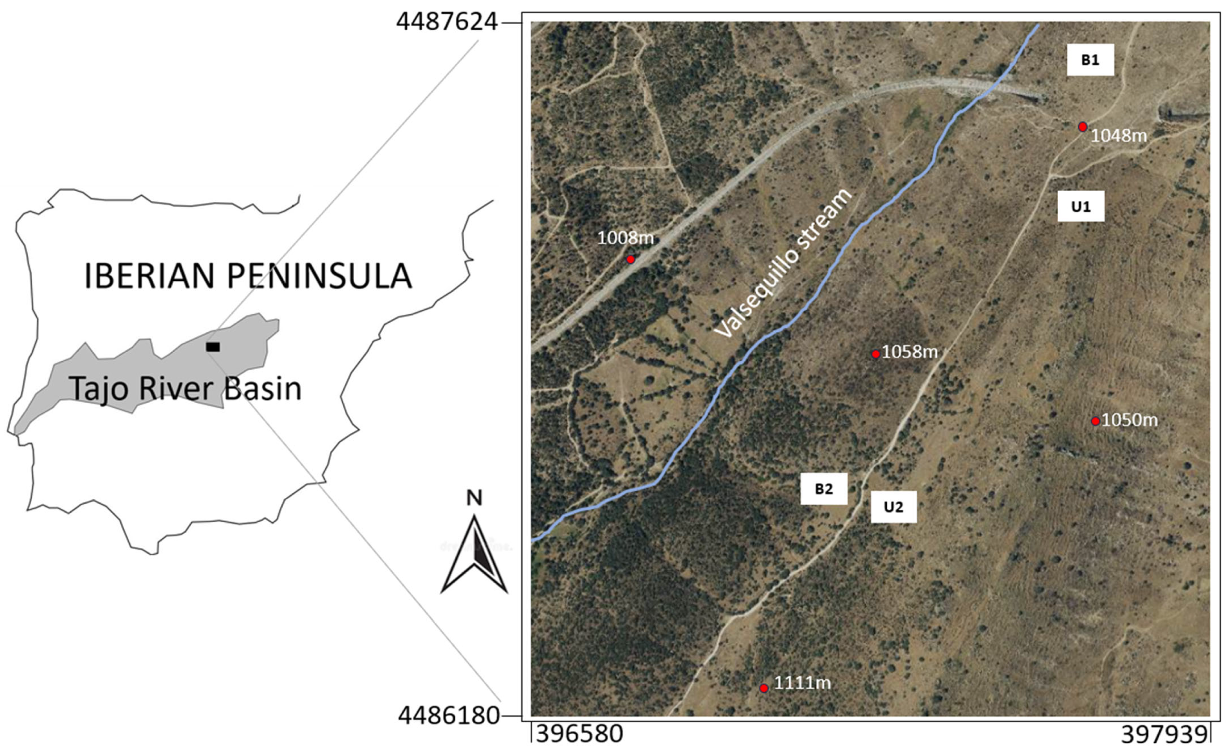
2.1. Study Area

The study area is located in the Sierra de Guadarrama mountains, in central Spain, specifically in the municipalities of Robledo de Chavela and Zarzalejos, within the Tajo River basin (Figure 1). Approximate UTM coordinates (Datum ETRS89) are 30T 397260, 4486902.
The climate of the area is Mediterranean-continental, temperate in terms of temperatures, and relatively humid due to precipitation, although with a summer drought (2.7 months of dry period). More specifically, the average annual temperature is 11.6 °C, the average minimum temperature in the coldest month (January) is −0.2 °C, and the average maximum temperature in the hottest month (July) is 29.5 °C. The average annual precipitation is 610 mm, and the potential evapotranspiration (Thornthwaite method) is 694 mm.
The soils in the area are classified as Xerorthents and Haploxerepts, formed on metamorphic and igneous rocks, primarily consisting of glandular orthogneisses and biotitic porphyritic adamellites. Generally, the soils exhibit clayey textures with 44% sand, 15% silt, and 41% clay (average values). The pH is 6.1, indicating slightly acidic soil, with no detectable carbonates. The organic matter content is quite high at 7.8%. The soil profiles shown in Figure 2 are quite typical of the area (A-Bw-C), with depths ranging from 23 to 36 cm to the C horizon. This C horizon is formed by the weathered parent rock, which at the plot locations corresponds to a glandular orthogneiss with potassium feldspar, plagioclase, quartz, and biotite. The alteration of these orthogneisses is quite strong, resulting in a C horizon that is highly fractured, friable, and very poorly compacted, crumbling to the touch but apparently preserving the structure of the original material. The C horizon is less clayey than the Bw and contains a much higher quantity of coarse elements (>2 mm).
The terrain is mountainous, with slopes ranging from 4% to 20%. The average altitude is around 1050 m, predominantly with a north-west orientation. The vegetation is influenced by human activities, forming a typical mosaic of pastures used for extensive livestock grazing, and holm oak forests (Quercus ilex ssp. ballota [Desf.] Samp.) interspersed with junipers (Juniperus oxycedrus L., 1753) and Quercus coccifera L., as well as some pine plantations (Pinus sylvestris L.). The selected plots are within the holm oak forest, which was partially affected by a fire in the summer of 2020. In these burned areas, only herbaceous species such as Trifolium angustifolium L., Eryngium creticum Lam., Eryngium campestre L., Echium vulgare L. and Jacobaea vulgaris Gaertn. are present. The importance of studying the effects of fires on the soil in these forest areas lies in the ecological significance of the Mediterranean Quercus forest, with its high biodiversity, its conservation interest, and the need for appropriate land use management.

2.2. Field Works

Four 20 × 20 m sampling plots were randomly selected, both on burned (B1 and B2) and unburned (U1 and U2) soil (Figure 1). The fire occurred in August 2020, burning 1073 ha; the degree of fire severity was ‘high’ in the burned areas studied (B1 and B2) [42]. Randomly distributed within each of these plots, three infiltration tests and six repellency tests (three in the original soil and three in soil excavated by 1 cm) were carried out. Sampling happened in May 2021; Figure 3 shows the state of the plots at the sampling time. In each plot, three infiltration tests were conducted (a total of 12 tests) using a single-ring flooding infiltrometer (Infiltest), ensuring that the soil was completely dry (at least ten days since the last rainfall). The infiltrometer has a metacrylate tube with a graduated scale for measurements and a steel tube to secure the metacrylate cylinder in the soil [22] (Figure 4). A small trench was excavated around the infiltrometer and filled with water to prevent lateral leakage, thus functioning as a double-ring infiltrometer. During the duration of the tests (3 h), 15 measurements were taken to determine the infiltration curves, the initial infiltration rate (f0), and the steady-state infiltration rate (fC), following the methodology used by Mongil-Manso et al. [22].
The hydrophobicity was determined using the “water drop penetration time” (WDPT) method [43] that was also used, for example, by Ceballos et al. [44], Korenkova et al. [45] and Alagna et al. [46], which involves placing distilled water drops of 0.05 mL (ten drops per test) on the soil from a height of 1 cm and recording the time it takes for them to infiltrate the soil [44]. The process was repeated after excavating the soil 1 cm, and removing the top layer [16]. In total, 24 hydrophobicity tests were carried out: 6 tests in each zone/plot, half in original soil and half in excavated soil. The classifications of Bisdom et al. [47] were used.

2.3. Sample Description and Preparation

Soil samples were collected from individual points at the same locations where the infiltration tests were conducted (plots B1, B2, U1, and U2). Three soil samples were taken from each plot, representative of the entire soil profile from 0 to 50 cm in depth. To perform this, at each point, two subsamples were taken (0–20 and 20–50 cm) and mixed in situ on a plastic cover. From the mixture, a sample was taken and stored in a bag, which was immediately taken to the laboratory for analysis. In total, 12 soil samples were taken from the respective plots.

2.4. Analytical Procedures

The samples were air-dried and roots, stones, and other debris were removed by sieving through a 2 mm sieve. Laboratory work involved determining parameters such as texture (USDA classification), along with the percentages of sand (SD), silt (ST), and clay (CY) using the Bouyoucos hydrometer method. Coarse elements (gravel) were assessed using a 2 mm sieve, and bulk density (BD) was measured using the cylinder method (three undisturbed samples from each point, extracted using steel cylinders with a height of 51 mm and a diameter of 50 mm). Additionally, the organic matter content (OM) was determined using the Walkley–Black method, pH was determined by potentiometry (water solution 1:2.5), and carbonates were determined using the Bernard calcimeter.

2.5. Data Analysis

Table 1 includes the maximal models, which contain all predictors, used for statistical analysis. For the infiltration rate, we developed a Linear Model -LM- [48,49] to analyse the data (I model). Treatment (forest vs. burnt forest) and soil variables were predictors in the maximal model I. Among soil variables, we included bulk density, organic matter, gravel, and fine soil (using sand which is correlated—r > 0.7—with silt and clay; Table A1) in the maximum models (Table 1) for their ecological interest. These soil variables were not correlated with each other (r < 0.7, Table A1). Furthermore, only treatment–density bulk interaction was included in the maximum model since the other interactions did not show any difference between treatment levels according to soil property in the exploratory analysis (Figure A1).
For repellency, we developed a Generalized Linear Mixed Model -GLMM- [50] to analyse the data (II model). Treatment (forest vs. burnt forest), soil depth (original vs. excavated soil) and the same soil variables included in the above maximal model (I) were predictors in the maximal model II. We included a test point nested within the plot as the random effect factor (Table 1). Furthermore, all double interactions were included in the maximum model II (Table 1).
In order to calculate the lambda transformation that maximizes the likelihood, we applied Box–Cox transformations to response variables when needed [51]. Thus, repellency for the maximal model II was fitted to Gamma error distribution with the value of −0.3 as the power lambda link function (Table 1). A Gaussian error distribution with an identity function was fitted for the infiltration response variable in model I since monotonic transformation was not necessary (Table 1).
A model averaging approach was used to select the best models derived from a maximal model [52]. For this, we first fitted the maximal model in each analysis (model I and II for infiltration and repellency analysis, respectively), containing all the predictors described above. Then, we ranked all the possible models derived from the maximal model I for infiltration and from the II model repellency analysis, respectively, through AIC weights using the “dredge” function within the “MuMIn” package of R. Finally, we selected those models (top models) which had accumulated 95% of the AIC weight and we obtained the model-averaged coefficients of them as well as the importance of each predictor (from 0 to 1) using the “model.avg” function of “MuMIn” [52].
We processed the data and performed statistics using R 4.2.1 [53] with the modules “lme4” [54], “ggplot” [55], “car” [56], and “MuMIn” [57].

3. Results

Table 2 presents the average results for the study variables across the four analysed plots (burnt and unburnt), along with the descriptive statistical parameters of the various variables. The mean initial infiltration rate (f0) is 1972.50 mm·h−1, with high values obtained at all sampling points. The mean final infiltration rate (fC) is 1010.50 mm·h−1, which is also a high value, with higher values in burnt than in unburnt soils. A sandy-clay texture is present in the soils, with a high OM content (mean value: 7.62%), and a significant presence of coarse elements larger than 2 mm (42%). The hydrophobicity estimated by WDPT in the original soil has a mean value of 4.59 s, while in the excavated soil, it amounts to 66.88 s.

3.1. Infiltration Rate

The forest fire significantly (p = 0.034) affected the infiltration rate of the soils (Table 3, I model), which was higher in the burnt forest area (1129.67 mm·h−1) than in the unburnt forest area (891.33 mm·h−1). No significant (p > 0.05) differences were observed in the infiltration rate according to the soil properties (Table 3, I model) and the treatment–bulk density interaction, which, in addition, showed a low relative importance in modelling (<0.40).
Figure 5 shows the infiltration curves for the four plots and 180 min of test duration. As usual, the infiltration rate is higher at the beginning of the measurements and gradually decreases until it becomes constant [16]. B1 and U1 show a higher initial infiltration rate, but at the end of the test, when the soil is saturated with water, B1 and B2 show the highest values. Figure 6 also depicts this, where the final steady-state infiltration rates for the four plots are shown.

3.2. Repellency

The forest fire and soil depth did not show significant (p > 0.05) differences once in a blue moon (Table 3, II model); however, these two variables interacting with some soil variables or being among them significantly affected repellency (Table 3, II model). Repellency was higher in excavated (62.47 s) than in original soil (2.18 s) and within burnt compared to unburnt forest areas, in which there were no significant differences between soil depth levels (⋍8 s; Figure 7).
Additionally, in burnt forest areas, repellency significantly increased with bulk density and gravel and decreased with sand (Figure A2). In unburnt forest areas, however, the repellency was not modified by bulk density, gravel, or sand (Figure A2).
Additionally, in excavated soil, the repellency significantly increased with bulk density and decreased with OM (Figure A3). However, in non-excavated soil, the repellency was not modified by bulk density and OM (Figure A3).
Figure 8 shows the frequency of hydrophobicity in burnt versus unburnt soils. Burnt soils show a lower frequency of hydrophobicity (slightly less than 30% of the samples), but severe hydrophobicity (above 300 s) is more frequent. In contrast, in the unburnt soils, hydrophobicity is present in 50% of the samples, but with lower repellency values and severe hydrophobicity is rare.

4. Discussion

Changes in hydrophobicity and infiltration caused by forest fires can have important consequences on hydrological processes, such as surface runoff and soil erosion [59,60], and this work investigates this in Mediterranean mountain areas. Additionally, the increase in runoff can cause ashes from the calcination of vegetation to be washed into watercourses, leading to pollution [3]. On the other hand, as Rubio et al. [11] and Figueiredo et al. [12] point out, in these Mediterranean areas, fire can be seen as a factor inducing desertification, which may also affect the post-fire restoration of the land.
We have studied infiltration and hydrophobicity in burnt Mediterranean mountain soils with acid pH soils, and the results obtained do not exactly follow the same patterns as the best-studied soils of the Spanish Levant and Southeast. The results of the infiltration tests do not correspond with most of the reviewed literature, which shows a decreased infiltration rate in burnt forest soil [26,27,28,61]. Ferreira et al. [62] attribute the lack of mulch as the fundamental reason for understanding the reduced infiltration. However, studies also conclude that there are no significant differences in the final infiltration rates between the burnt and unburnt areas [63]. Some previous studies validate the use of a ring infiltrometer to measure infiltration in burnt soils and compare it with unburnt soils [24,25]. Similarly, Cerdà [64], using a ring infiltrometer, found that recently burnt soil (six months) had lower infiltration rates than soil that burnt nine and a half years earlier.
In our study, all the examined soils exhibit elevated infiltration rates, saturating the soil at levels exceeding 800 mm·h−1. Despite the soils sharing similar physical and chemical characteristics, there is a discernible difference in the final infiltration rate (fC), with burnt soils demonstrating higher rates compared to unburnt ones. In this case, the infiltration tests happened nine months after the fire. The reasons for these results are possibly to be found in issues such as the destruction of certain organic compounds that may hinder the entry of water or the presence of herbaceous vegetation after the fire which, with its roots, favours infiltration [65].
Regarding hydrophobicity, in general, the contribution of ash or other compounds formed during the fire from organic matter in the soil can produce repellency [30,31]. In view of the results obtained, it can be stated that fire modifies the water repellency of the soil. The general pattern in Mediterranean calcareous soils shows that fire increases hydrophobicity in soils, as well as persistence values [29,66]. However, in our case, where the soils are not calcareous, this pattern does not exactly hold true.
For example, in our study, in burnt soils, hydrophobicity differs between the original soil (with a higher amount of OM before the fire) and the soil excavated by 1 cm, while unburnt soils show no such differences. This is consistent with the results obtained by Robichaud et al. [60] in Montana (USA). During a fire, in the first few centimetres of the soil, distillation of certain organic compounds occurs, and some of these gases may move into the soil and condense around aggregates and mineral particles where temperatures are lower [32].
Similarly, in burnt soils, hydrophobicity increases with the percentage of coarse elements and bulk density and decreases with the percentage of sand, while in unburnt soils, there are no such differences. It would be necessary to know the characteristics of the fire (intensity, time of permanence, and temperature reached), since, as Celis [67] indicates, water repellency in the soil can be caused, increased, or decreased by the temperature reached in a fire, which varies greatly, depending on many factors, such as the intensity of the fire, the amount of fuel, or the time the fire remains in a given area. Additionally, there is also temperature variation between the surface of the soil and deeper layers, which implies the difference between hydrophobicity at the surface and below the surface [68]. Moreover, the OM content of the soil, the presence of clay, and the type of mineralogy seem to be key factors in preventing water repellency in certain soils [69,70].
The hydrophobicity values obtained by the WDPT test are very varied, which is not surprising as, according to Doerr et al. [71] or Arcenegui et al. [69], the passage of fire can increase or decrease hydrophobicity, depending on other factors such as the severity of the fire [71], the mineralogy and texture of the soil, or the amount and type of vegetation. Thus, we have found low repellency values (even lower than 10 s) together with much higher ones (above 600 s). Analysing the frequency of hydrophobicity, the results show that burnt soils have a low frequency of hydrophobicity (in less than 30% of the samples) but with a more severe hydrophobicity (above 300 s); whereas, in unburnt soils, the frequency is higher (50%) but the values are lower. This contrasts with what occurs in the limestone soils of southeastern Spain, where hydrophobicity is in around 25% of the unburnt soil samples, but in 75% of the burnt soils [29]. Additionally, in soils with acid pHs, as is in the case study, hydrophobicity values are higher than in soils with a more basic pH [33,72].

5. Conclusions

After a forest fire, the analysis of hydrophobicity and infiltration at the hillslope scale is fundamental because they may be responsible, together with other factors, for the increased surface runoff and soil erosion, with consequences also for post-fire restoration.
In this work, we have studied these processes related to the entry of water into the soil in Mediterranean mountain areas, under acidic pH soils formed from magmatic rocks. The results show that, contrary to previous hypotheses, the infiltration increases nine months after the fire and hydrophobicity is less frequent in burnt soils, but its values are higher. In short, although these results should be applied exclusively to soils such as those studied, it cannot be affirmed that the hydrological conditions of the soils worsen after the fire in terms of water entering the soil. However, other factors, such as the absence of woody vegetation, may increase surface runoff and soil erosion. The results obtained may be useful in decision-making for land managers, hydrologists, and those responsible for the forest restoration of burnt land.

Author Contributions

Conceptualization, J.M.-M. and V.R.-P.; methodology, J.M.-M., A.L.-S. and V.R.-P.; software, A.L.-S.; validation, J.M.-M. and A.L.-S.; formal analysis, J.M.-M. and A.L.-S.; investigation, J.M.-M., A.L.-S. and V.R.-P.; resources, J.M.-M.; writing—original draft preparation, J.M.-M.; writing—review and editing, J.M.-M., A.L.-S. and V.R.-P.; supervision, J.M.-M. All authors have read and agreed to the published version of the manuscript.

Funding

This research received no external funding.

Data Availability Statement

The data presented in this study are available on request from the corresponding author.

Acknowledgments

The authors would like to express their gratitude to the Catholic University of Ávila.

Conflicts of Interest

The authors declare no conflicts of interest.

Appendix A

Table A1. Pearson’s correlation coefficient matrix of the soil variables.
Bulk DensityOrganic MatterGravelSandSiltyClay
Bulk density1
Organic matter0.2001
Gravel0.3700.0051
Sand0.0930.1800.3501
Silty0.2100.1000.4600.821
Clay0.0490.2100.1200.840.381
Figure A1. Infiltration rate (mm/h) depending on interaction of treatment and soil properties: (i) treatment–density bulk; (ii) treatment–organic matter; (iii) treatment–gravel; and (iv) treatment–sand (N = 12 samples). Forest = non-fire-affected forest area; Burn forest = fire-affected forest area.
Forests 15 02033 g0a1
Figure A2. Water repellence time (s) depending on interaction of treatment and soil properties: (i) treatment–density bulk; (ii) treatment–gravel; and (iii) treatment–sand (N = 240 samples). Forest = non-fire-affected forest area; Burn forest = fire-affected forest area.
Forests 15 02033 g0a2
Figure A3. Water repellence time (s) depending on interaction of soil depth and soil properties: (i) soil depth–density bulk; (ii) soil depth–organic matter (N = 240 samples). Excavated soil = soil excavated 1 cm; Original soil = non-excavated soil.
Forests 15 02033 g0a3

References

  1. Pausas, J.G.; Keeley, J.E. A burning story: The role of fire in the history of life. Bioscience 2009, 59, 593–601. [Google Scholar] [CrossRef]
  2. Nolan, R.H.; Anderson, L.O.; Poulter, B.; Varner, J.M. Increasing threat of wildfires: The year 2020 in perspective: A Global Ecology and Biogeography special issue. Glob. Ecol. Biogeogr. 2022, 31, 1898–1905. [Google Scholar] [CrossRef]
  3. Mataix-Solera, J.; Cerdà, A. Los efectos de los incendios forestales en los suelos. Síntesis y conclusiones. Nuevos retos en la investigación y en la gestión. In Efectos de los Incendios Forestales Sobre los Suelos en España. El Estado de la Cuestión Visto por los Científicos Españoles; Cerdà, J., Mataix-Solera, J., Eds.; Càtedra de Divulgació de la Ciència, Universitat de Valencia: Valencia, Spain, 2009. [Google Scholar]
  4. Sanz, I.; Aguilar, C.; Millares, A. Evaluation of post fire changes in soil properties and influence on the hydrological and erosive dynamics un a Mediterranean watershed. Geophys. Res. Abstr. 2013, 15, EGU2013–EGU14006. [Google Scholar]
  5. Turco, M.; Llasat, M.C.; von Hardenberg, J.; Provenzale, A. Climate change impacts on wildfires in a Mediterranean environment. Clim. Chang. 2014, 125, 369–380. [Google Scholar] [CrossRef]
  6. Doerr, S.H.; Cerda, A. Fire effects on soil system functioning: New insights and future challenges. Int. J. Wildland Fire 2005, 14, 339–342. [Google Scholar] [CrossRef]
  7. Úbeda, X.; Mataix-Solera, J. Fire effects on soil properties: A key issue in forest ecosystems—Preface. Catena 2008, 74, 175–176. [Google Scholar] [CrossRef]
  8. Cerdà, A.; Robichaud, P.R. (Eds.) Fire Effects on Soils and Restoration Strategies; Land reconstruction and management series; Science Publishers: Enfield, NH, USA, 2009; Volume 5, 589p. [Google Scholar]
  9. Certini, G.; Moya, D.; Lucas-Borja, M.E.; Mastrolonardo, G. The impact of fire on soil-dwelling biota: A review. For. Ecol. Manag. 2021, 488, 118989. [Google Scholar] [CrossRef]
  10. Moody, J.A.; Martín, D.A. Synthesis of sediment yields after wildland fire in different rainfall regimes in the western United States. Int. J. Wildland Fire 2009, 18, 96–115. [Google Scholar] [CrossRef]
  11. Rubio, J.L. Desertificación. In Paisaje y Vegetación Mediterránea; Ayuntamiento de Valencia: Valencia, Spain, 1997. [Google Scholar]
  12. Figueiredo, T.; Fonseca, F.; Pinheiro, H. Fire hazard and susceptibility to desertification: A territorial approach in NE Portugal. In Multidimensão e Territórios de Risco III Congresso Internacional I Simpósio Ibero-Americano VIII Encontro Nacional de Riscos; RISCOS: Guimarães, Portugal, 2014. [Google Scholar]
  13. Pierson, F.B.; Robichaud, P.R.; Moffet, C.A.; Spaeth, K.E.; Williams, C.J.; Hardegree, S.P.; Clark, P.E. Soil water repellency and infiltration in coarse-textured soils of burned and unburned sagebrush ecosystems. Catena 2008, 74, 98–108. [Google Scholar] [CrossRef]
  14. Johnson, A.I. A Field Method for Measurement of Infiltration; Paper 1544-F; Geological Survey Water-Supply: Washington, DC, USA, 1963. [Google Scholar]
  15. Perkins, K.S.; Nimmo, J.R.; Medeiros, A.C. Effects of native forest restoration on soil hydraulic properties, Auwahi, Maui, Hawaiian Islands. Geophys. Res. Lett. 2012, 39, L05405. [Google Scholar] [CrossRef]
  16. Mongil-Manso, J.; Navarro-Hevia, J.; San Martín, R. Impact of land use change and afforestation on soil properties in a Mediterranean mountain area of Central Spain. Land 2022, 11, 1043. [Google Scholar] [CrossRef]
  17. Mapa, R.B. Effect of reforestation using Tectona grandis on infiltration and soil water retention. For. Ecol. Manag. 1995, 77, 119–125. [Google Scholar] [CrossRef]
  18. Zhang, J.; Bruijnzeel, L.A.; Quiñones, C.M.; Tripoli, R.; Asio, V.B.; van Meerveld, H.J. Soil physical characteristics of a degraded tropical grassland and a ‘reforest’: Implications for runoff generation. Geoderma 2019, 333, 163–177. [Google Scholar] [CrossRef]
  19. Hayati, E.; Abdi, E.; Mohseni Saravi, M.; Nieber, J.L.; Majnounian, B.; Chirico, G.B.; Wilson, B.; Nazarirad, M. Soil water dynamics under different forest vegetation cover: Implications for hillslope stability. Earth Surf. Process. Landf. 2018, 43, 2106–2120. [Google Scholar] [CrossRef]
  20. Zwartendijk, B.W.; van Meerveld, H.J.; Ghimire, C.P.; Bruijnzeel, L.A.; Ravelona, M.; Jones, J.P.G. Rebuilding soil hydrological functioning after swidden agriculture in eastern Madagascar. Agric. Ecosyst. Environ. 2017, 239, 101–111. [Google Scholar] [CrossRef]
  21. Hrabovský, A.; Dlapa, P.; Cerdà, A.; Kollár, J. The impacts of vineyard afforestation on soil properties, water repellency and near-saturated infiltration in the Little Carpathians Mountains. Water 2020, 12, 2550. [Google Scholar] [CrossRef]
  22. Mongil-Manso, J.; Navarro-Hevia, J.; San Martín, R. Does forest restoration influence soil infiltrability? A case study in the restored woodland of Sierra de Ávila (Central Spain). J. Mt. Sci. 2021, 18, 1778–1793. [Google Scholar] [CrossRef]
  23. Rahmati, M.; Weihermüller, L.; Vanderborght, J.; Pachepsky, Y.A.; Mao, L.; Sadeghi, S.H.; Moosavi, N.; Kheirfam, H.; Montzka, C.; Van Looy, K.; et al. Development and analysis of the soil water infiltration global database. Earth Syst. Sci. Data 2018, 10, 1237–1263. [Google Scholar] [CrossRef]
  24. Cerdà, A. La Infiltración de los Suelos del País Valenciano: Factores y Variaciones Espacio-Temporales; Servei de Publicacions de la Universitat de València: Valencia, Spain, 1993; p. 357. [Google Scholar]
  25. Cerdà, A. Factores y Variaciones Espacio-Temporales de la Infiltración en los Ecosistemas Mediterráneos; Monografías Científicas nº 5; Geoforma Ediciones: Logroño, Spain, 1995. [Google Scholar]
  26. Neris, J.; Tejedor, M.; Fuentes, J.; Jiménez, C. Infiltration, runoff and soil loss in Andisols affected by forest fire (Canary Islands, Spain). Hydrol. Process. 2012, 27, 2814–2824. [Google Scholar] [CrossRef]
  27. Inbar, A.; Lado, M.; Sternberg, M.; Tenaw, H.; Ben-Hur, M. Forest fire effects on soil chemical and physicochemical properties, infiltration, runoff, and erosion in a semiarid Mediterranean region. Geoderma 2014, 221–222, 131–138. [Google Scholar] [CrossRef]
  28. Moody, J.A.; Ebe, B.A. Infiltration and runoff generation processes in fire-affected soils. Hydrol. Process. 2014, 28, 3432–3453. [Google Scholar] [CrossRef]
  29. Arcenegui, V.; Mataix-Solera, J.; Guerrero, C.; Zornoza, R.; Mataix-Beneyto, J.; García-Orenes, F. Immediate effects of wildfires on water repellency and aggregate stability in Mediterranean calcareous soils. Catena 2008, 74, 219–226. [Google Scholar] [CrossRef]
  30. Doerr, S.H.; Shakesby, R.A.; MacDonald, L.H. Soil Water repellency: A key factor in post-fire erosion. In Fire Effects on Soils and Restoration Strategies; CRC Press: Boca Raton, FL, USA, 2009; 28p. [Google Scholar]
  31. Mao, J.; Nierop, K.G.J.; Dekker, S.C.; Dekker, L.W.; Chen, B. Understanding the mechanisms of soil water repellency from nanoscale to ecosystem scale: A review. J. Soils Sediments 2018, 19, 171–185. [Google Scholar] [CrossRef]
  32. DeBano, L.F.; Mann, L.D.; Hamilton, D.A. Translocation of hydrophobic substances into soil by burning organic litter. Soil Sci. Soc. Am. J. 1970, 34, 130–133. [Google Scholar] [CrossRef]
  33. Varela, M.E.; Benito, E.; de Blas, E. Impact of wildfires on surface water repellency in soils of NW Spain. Hydrol. Process. 2005, 19, 3649–3657. [Google Scholar] [CrossRef]
  34. Doerr, S.H.; Blake, W.H.; Shakesby, R.A.; Stagnitti, F.; Vuurens, S.H.; Humphreys, G.S.; Wallbrink, P. Heating effects on water repellency in Australian eucalypt forest soils and their value in estimating wildfire soil temperatures. Int. J. Wildland Fire 2004, 13, 157–163. [Google Scholar] [CrossRef]
  35. García-Corona, R.; Benito, E.; de Blas, E.; Varela, M.E. Effects of heating on some soil physical properties related to its hydrological behaviour in two north-western Spanish soils. Int. J. Wildland Fire 2004, 13, 195–199. [Google Scholar] [CrossRef]
  36. DeBano, L.F.; Savage, S.M.; Hamilton, D.A. The transfer of heat and hydrophobic substances during burning. Soil Sci. Soc. Am. J. 1976, 40, 779–782. [Google Scholar] [CrossRef]
  37. Bodí, M.B.; Cerdà, A.; Mataix-Solera, J.; Doerr, S.H. Efectos de los incendios forestales en la vegetación y el suelo en la cuenca mediterránea: Revisión bibliográfica. Bol. Asoc. Geogr. Esp. 2012, 58, 33–55. [Google Scholar] [CrossRef]
  38. Francos, M.; Velasco, A.; Úbeda, X. Hidrofobicidad en suelos quemados a diferente intensidad. Efectos a largo plazo y ensayos de laboratorio. In Avances de la Geomorfología en España; Sociedad Española de Geomorfología: Cáceres, Spain, 2014; pp. 188–191. [Google Scholar]
  39. Rodríguez-Alleres, M.; Benito, E.; De Blas, E. Implicaciones de la repelencia al agua del suelo en la generación de escorrentía y en la erosión en un área quemada del NW de España. Estud. Zona Saturada Suelo 2005, 7, 165–168. [Google Scholar]
  40. Bodí, M.B.; Cerdà, A.; Mataix-Solera, J.; Doerr, S.H. Repelencia al agua en suelos forestales afectados por incendios y en suelos agrícolas bajo distintos manejos y abandono. Cuad. Investig. Geog. 2012, 38, 53–74. [Google Scholar] [CrossRef]
  41. Jaramillo, D.F. Repelencia al agua en suelos: Una síntesis. Rev. Acad. Colomb. Cienc. Exactas Físicas Nat. 2006, 30, 215–232. [Google Scholar] [CrossRef]
  42. Fernández-García, V.; Miesel, J.; Baeza, M.J.; Marcos, E.; Calvo, L. Wildfire effects on soil properties in fire-prone pine ecosystems: Indicators of bur severity legacy over the medium term after fire. Appl. Soil Ecol. 2019, 135, 147–156. [Google Scholar] [CrossRef]
  43. Letey, J. Measurement of contact angle, water drop penetration time, and critical surface tension. In Proceedings of the Symposium on Water-Repellent Soils, Riverside, CA, USA, 6–10 May 1968; pp. 43–47. [Google Scholar]
  44. Ceballos, A.; Ferreira, A.J.D.; Coelho, C.O.A.; Boulet, A.K. Análisis de la repelencia al agua en una pequeña cuenca hidrográfica afectada por fuego controlado en el área montañosa central de Portugal. Pirineos 1999, 153, 123–143. [Google Scholar] [CrossRef]
  45. Korenkova, L.; Simkovic, I.; Dlapa, P.; Urik, M. Statistical assessment of relationship between water repellency and selected properties of forest topsoil in the white Carpathian MTS. Carpathian J. Earth Environ. Sci. 2016, 11, 405–414. [Google Scholar]
  46. Alagna, V.; Iovino, M.; Bagarello, V.; Mataix-Solera, J.; Lichner, L. Application of minidisk infiltrometer to estimate water repellency in Mediterranean pine forest soils. J. Hydrol. Hydromech. 2017, 65, 254–263. [Google Scholar] [CrossRef]
  47. Bisdom, E.B.A.; Dekker, L.W.; Schoute, J.F.T. Water repellent of sieve fractions from sandy soils and relationships with organic material and soil structure. Geoderma 1993, 56, 105–118. [Google Scholar] [CrossRef]
  48. Carmona, F. Modelos Lineales; Publicaciones Universidad de Barcelona: Barcelona, Spain, 2005. [Google Scholar]
  49. Dobson, A.J. An Introduction to Generalized Linear Models, 2nd ed.; Chapman & Hall/CRC texts in statistical science series; Chapman and Hall/CRC: London, UK, 2002. [Google Scholar]
  50. Venables, W.N.; Ripley, B.D. Random and mixed effects. In Modern Applied Statistics with S. ed.; Springer Verlag: New York, NY, USA, 2002; pp. 271–300. [Google Scholar]
  51. Box, G.E.; Cox, D.R. An analysis of transformations. J. R. Stat. Soc. Series B Stat. Methodol. 1964, 26, 211–243. [Google Scholar] [CrossRef]
  52. Burnham, K.P.; Anderson, D.R. Model Selection and Multi-Model Inference: A Practical Information-Theoretic Approach, 2nd ed.; Springer Verlag: New York, NY, USA, 2002. [Google Scholar]
  53. R Core Team. R: A Language and Environment for Statistical Computing; R Foundation for Statistical Computing: Vienna, Austria, 2022. [Google Scholar]
  54. Bates, D.; Maechler, M.; Bolker, B.; Walker, S. Fitting linear mixed-effects models using lme4. J. Stat. Softw. 2015, 67, 1–48. [Google Scholar] [CrossRef]
  55. Wickham, H. Elegant Graphics for Data Analysis; Springer-Verlag: New York, NY, USA, 2016. [Google Scholar]
  56. Fox, J.; Weisberg, S. Package ‘Car’; R Foundation for Statistical Computing: Vienna, Austria, 2012. [Google Scholar]
  57. Barton, K. MuMIn: Multi-Model Inference, R Package Version 1.47.1.; CRAN R-Project: Vienna, Austria, 2022. [Google Scholar]
  58. Horton, R.E. An approach toward a physical interpretation of infiltration-capacity. Soil Sci. Soc. Am. Proc. 1940, 5, 399–417. [Google Scholar] [CrossRef]
  59. Imeson, A.C.; Verstraten, J.M.; Van Mulligen, E.J.; Senvink, J. The effects of fire and water repellency on infiltration and runoff under Mediterranean type forest. Catena 1992, 19, 345–361. [Google Scholar] [CrossRef]
  60. Robichaud, P.; Wagenbrenner, J.W.; Pierson, F.B.; Spaeth, K.E.; Ashmun, L.E.; Moffet, C.A. Infiltration and interrill erosion rates after a wildfire in western Montana, USA. Catena 2016, 142, 77–88. [Google Scholar] [CrossRef]
  61. Úbeda, X.; Sala, M. Cambios en la física del suelo e incremento de la escorrentía y la erosión tras un incendio forestal. Cad. Lab. Xeol. Laxe 1996, 21, 559–572. [Google Scholar]
  62. Ferreira, A.J.D.; Coelho, C.O.A.; Ritsema, C.J.; Boulet, A.K.; Keizer, J.J. Soil and water degradation processes in burned areas: Lessons learned from a nested approach. Catena 2008, 74, 273–285. [Google Scholar] [CrossRef]
  63. Molina, D.M. Efectos del fuego controlado en la velocidad de infiltración del agua en los suelos forestales: Un caso de estudio en la costa norte de California. Investig. Agraria. Sist. Recur. For. 1993, 2, 173–184. [Google Scholar]
  64. Cerdà, A. Seasonal variability of infiltration rates under contrasting slope conditions in Southeast Spain. Geoderma 1996, 69, 217–232. [Google Scholar] [CrossRef]
  65. Wu, G.L.; Liu, Y.; Yang, Z.; Cui, Z.; Deng, L.; Chang, X.F.; Shi, Z.H. Root channels to indicate the increase in soil matrix water infiltration capacity of arid reclaimed mine soils. J. Hydrol. 2017, 546, 133–139. [Google Scholar] [CrossRef]
  66. Mataix-Solera, J.; Doerr, S.H. Hydrophobicity and aggregate stability in calcareous topsoils from fire affected pine forests in south-eastern Spain. Geoderma 2004, 118, 77–88. [Google Scholar] [CrossRef]
  67. Celis, R.D.; Jordán López, A.; Martínez Zavala, L.M. Efectos del fuego en las propiedades biológicas, físicas y químicas del suelo. In Grandes Incêndios Florestais, Erosão, Degradação e Medidas de Recuperação dos Solos; Bento-Gonçalves, A., Vieira, A., Eds.; Núcleo de Investigação em Geografia e Planeamento: Guimaraes, Portugal, 2013; pp. 145–160. [Google Scholar]
  68. DeBano, L.F.; Krammes, J.S. Water repellent soils and their relation to wildfire temperatures. Int. Assoc. Sci. Hydrol. Bull. 1966, 11, 14–19. [Google Scholar] [CrossRef]
  69. Arcenegui, V.; Mataix-Solera, J.; Guerrero, C.; Zornoza, R.; Mayoral, A.M.; Morales, J. Factors controlling the water repellency induced by fire in calcareous Mediterranean forest soils. Eur. J. Soil Sci. 2007, 58, 1254–1259. [Google Scholar] [CrossRef]
  70. Mataix-Solera, J.; Arcenegui, V.; Guerrero, C.; Jordán, M.; Dlapa, P.; Tessler, N.; Wittenberg, L. Can terra rossa become water repellent by burning? A laboratory approach. Geoderma 2008, 147, 178–184. [Google Scholar] [CrossRef]
  71. Doerr, S.H.; Shakesby, R.A.; Blake, W.H.; Humphreys, G.S.; Chafer, C.; Wallbrink, P.J. Effects of contrasting wildfire severity on soil wettability in Australian eucalypt catchments. J. Hydrol. 2006, 319, 295–311. [Google Scholar] [CrossRef]
  72. Doerr, S.H.; Shakesby, R.A.; Walsh, R.P.D. Soil hydrophobicity variations with depth and particle size fraction in burned and unburned Eucalyptus globulus and Pinus pinaster forest terrain in the Águeda basin, Portugal. Catena 1996, 27, 25–47. [Google Scholar] [CrossRef]
Figure 1. Location of the study area in the Tajo River basin and sampling plots (B1, B2, U1, and U2).
Forests 15 02033 g001
Figure 2. Representative soil profile diagrams for unburnt and burnt sites.
Forests 15 02033 g002
Figure 3. Sampling plots in burnt area (B1 and B2) and unburnt area (U1 and U2).
Forests 15 02033 g003
Figure 4. Infiltest infiltrometer used in this study.
Forests 15 02033 g004
Figure 5. Infiltration curves for the four plots, obtained by Horton’s equation [58].
Forests 15 02033 g005
Figure 6. Final steady infiltration rates (fC) and standard deviation for the four plots.
Forests 15 02033 g006
Figure 7. Water repellency time (s) depending on the interaction of treatment and soil depth (N = 240 samples). Forest = non-fire-affected forest area; Burnt forest = fire-affected forest area. Excavated soil = soil excavated 1 cm; Original soil = non-excavated soil; Different letters (a, b) denote statistically significant differences, α = 0.05.
Forests 15 02033 g007
Figure 8. Frequency of the presence of hydrophobicity in burnt compared to unburnt soils. The graph shows the percentage of samples in each hydrophobicity class: hydrophilic if WDPT < 5 s, hydrophobic if WDPT > 5 s.
Forests 15 02033 g008
Table 1. Summary of maximal models performed for data analysis.
Type of Model 1ModelResponse VariablePredictor/Fixed Effect 2Random EffectError Distribution
(Power Lambda Link Function) 3
Sample Size (n)
LMIInfiltrationT×BD + OM + G + SD---Gaussian (1)12
GLMMIIRepellencyT×D + T×BD + T×OM + T×G + T×SD + D×BD + D×OM + D×G + D×SD1|Plot–Test pointGamma (−0.3)240
1 LM: Linear Mixed Model; GLMM: Generalized Linear Mixed Model. 2 T: Treatment (forest vs. burnt forest); BD: Bulk Density; OM: Organic Matter; G: Gravel; SD: Sand; D: Depth soil (original vs. excavated soil). 3 Power lambda link function [g(m) = ml] used for the monotonic transformations.
Table 2. Mean values for study variables for the four zones (B1, B2, U1, and U2). The soil properties are representative of the 0–50 cm depth.
VariableB1U1B2U2MeanStd DevMaxMinn
FireBurntUnburntBurntUnburnt-----
OrientationNWNWNWNW-----
SL (%)111848-----
Forest cover0.000.200.000.400.150.190.400.0012
Herbaceous cover0.530.770.430.130.470.261.000.1012
f0 (mm·h−1)2430.002050.001660.001750.001972.50347.603000.001660.0012
fC (mm·h−1)1199.33889.331060.00893.331010.50148.901330.00790.0012
WDPTO (s)2.991.332.8611.194.594.4618.321.3330
WDPTE (s)118.7183.0557.748.0066.8846.54283.371.2730
G (%)43.048.043.034.042.05.756.034.012
SD USDA (%)41.034.053.046.044.08.269.030.012
ST USDA (%)18.022.011.012.016.05.125.011.012
CL USDA (%)41.044.036.042.041.03.553.034.012
OM (%)6.707.548.168.107.620.6710.815.6812
BD (g·cm−3)1.351.291.071.181.220.121.540.9512
pH6.16.16.06.06.10.16.45.712
CarbonatesNDNDNDND----12
Abbreviations: NW = North-west; f0 = initial infiltration rate; fC = steady-state infiltration rate; SL = slope; G = gravel; SD = sand; ST = silt; CL = clay; WDPTO = hydrophobicity WDPT method original soil; WDPTE = hydrophobicity WDPT method excavated soil; OM = organic matter; BD = bulk density; ND = not detectable.
Table 3. Summary of the top linear models (Cumulative Weight > 0.95) to analyse the infiltration rate (I model) and repellency (II model) depending on treatment (covariates: bulk density, organic matter, gravel, and sand are also included) and soil depth (only within II model).
ModelFixed EffectsImportanceLevelsCoeff.SEz-Valuep
IIntercept 868.96079.7009.345<0.001
Treatment (T)0.93Burn F.283.810113.8702.1170.034
Bulk Density (BD)0.56 118.200111.4500.9150.360
Organic Matter (OM)0.29 13.06059.0100.1830.855
Gravel (G)0.34 −12.64078.9400.1380.891
Sand (SD)0.62 −87.27058.7401.2330.218
T × BD0.39TBurn F. × BD−185.140118.9901.2700.204
IIIntercept 2.5770.3936.551<0.001
Treatment (T)1.00Burn F.0.1370.7020.1940.846
Soil Depth (D)0.99Original S.−0.5600.5021.1130.266
Bulk Density (BD)1.00 −0.3010.3170.9470.343
Organic Matter (OM)0.54 −0.3020.3530.8530.393
Gravel (G)0.99 0.4030.1812.2210.026
Sand (SD)1.00 0.5930.2272.6030.009
T × D0.63TBurnt F. × DOriginal S.−1.6900.5173.2590.001
T × BD1.00TBurnt F. × BD1.1740.09612.222<0.001
T × OM0.15TBurnt F. × OM−0.0780.2230.3460.729
T × G0.98TBurnt F. × G−1.1940.1966.050<0.001
T × SD0.99TBurnt F. × SD−1.1750.1269.277<0.001
D × BD0.64DOriginal S. × BD−0.7980.1774.480<0.001
D × OM0.29DOriginal S. × OM0.7210.3372.1270.033
D × G0.32DOriginal S. × G−0.3280.2981.0990.272
D × SD0.34DOriginal S. × SD0.3620.3321.0860.278
Importance: Importance of predictor variable in the model averaging. Results from treatment are against control forest and results from soil depth are against excavated soil. Bold type indicates statistical significance (p < 0.05).
Disclaimer/Publisher’s Note: The statements, opinions and data contained in all publications are solely those of the individual author(s) and contributor(s) and not of MDPI and/or the editor(s). MDPI and/or the editor(s) disclaim responsibility for any injury to people or property resulting from any ideas, methods, instructions or products referred to in the content.

