
Estimation of Aboveground Biomass for Different Forest Types Using Data from Sentinel-1, Sentinel-2, ALOS PALSAR-2, and GEDI

 ,
,  ,
,  ,
,  and
and
Abstract
1. Introduction
2. Materials and Methods
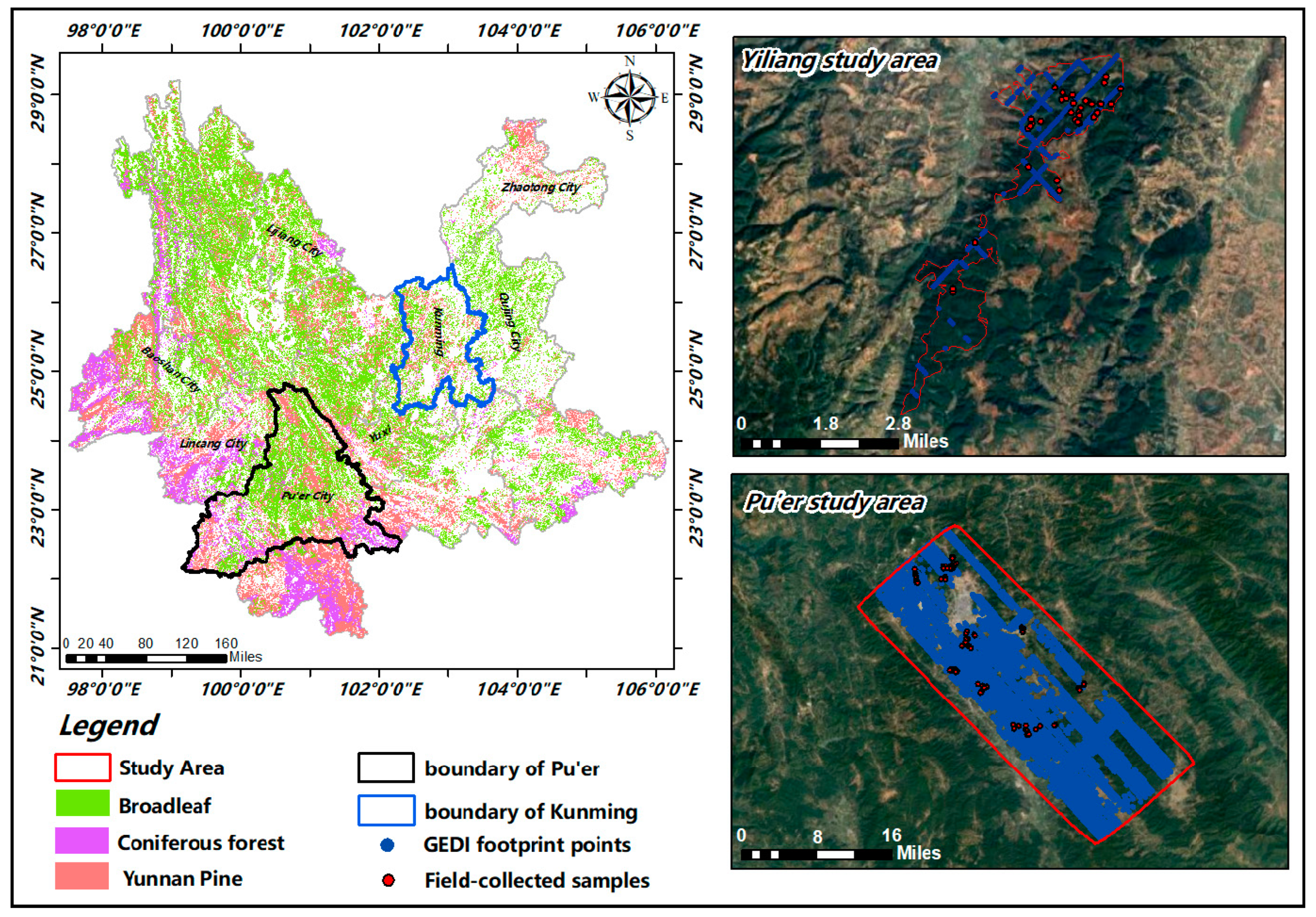
2.1. Study Area Overview and Field Campaign
2.1.1. Pu’er Study Area
2.1.2. Yiliang Study Area
2.2. Satellite Data
2.3. Methodology
2.4. Model Evaluation
3. Results
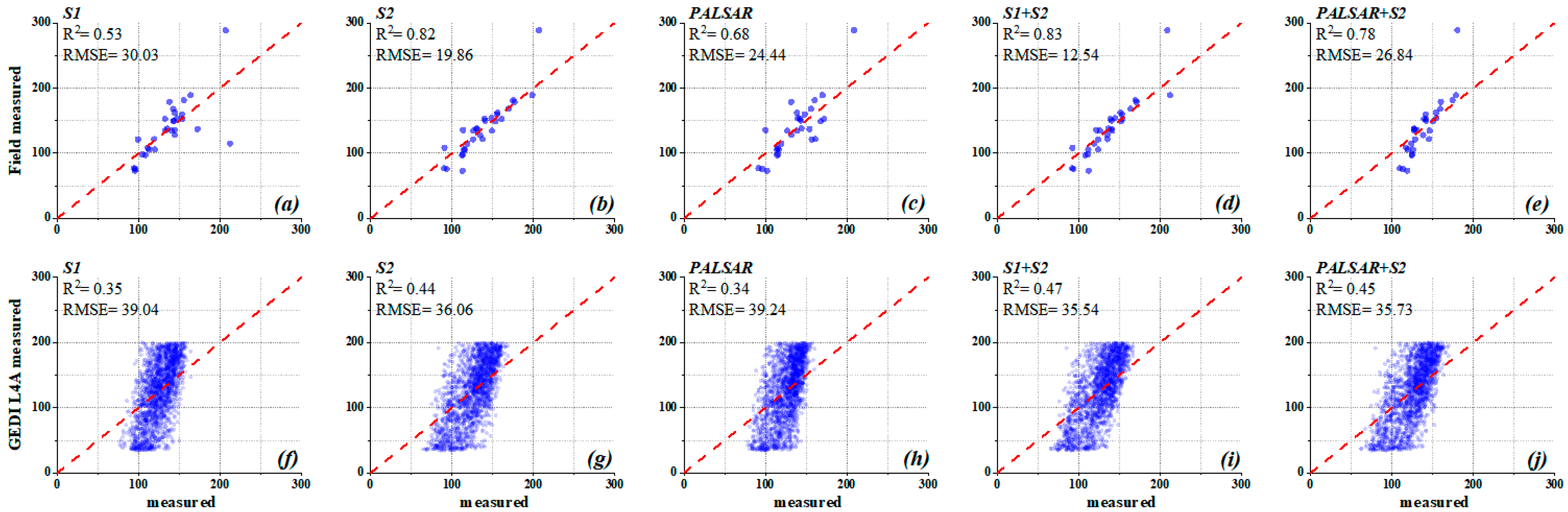
3.1. Performance of the Algorithm
3.2. Forest AGB Estimation for Whole Forest Type
3.3. Forest AGB Estimation for Different Forest Types
3.3.1. Broadleaf Forests
3.3.2. Coniferous Forests in Pu’er
3.3.3. Coniferous Forests in Yiliang
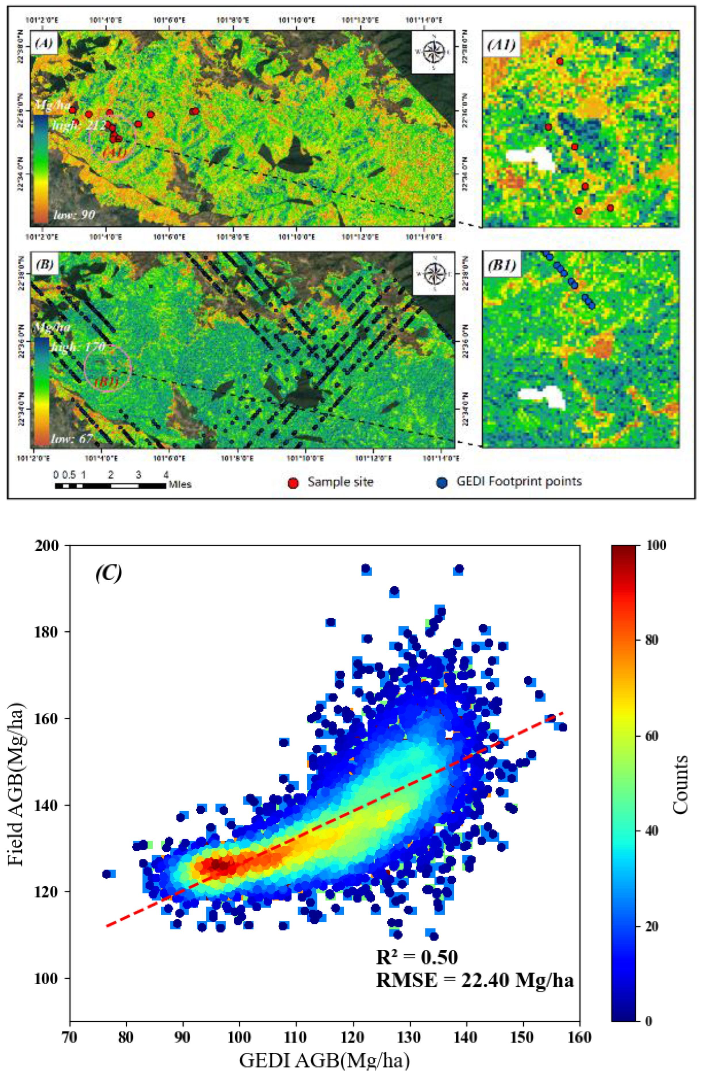
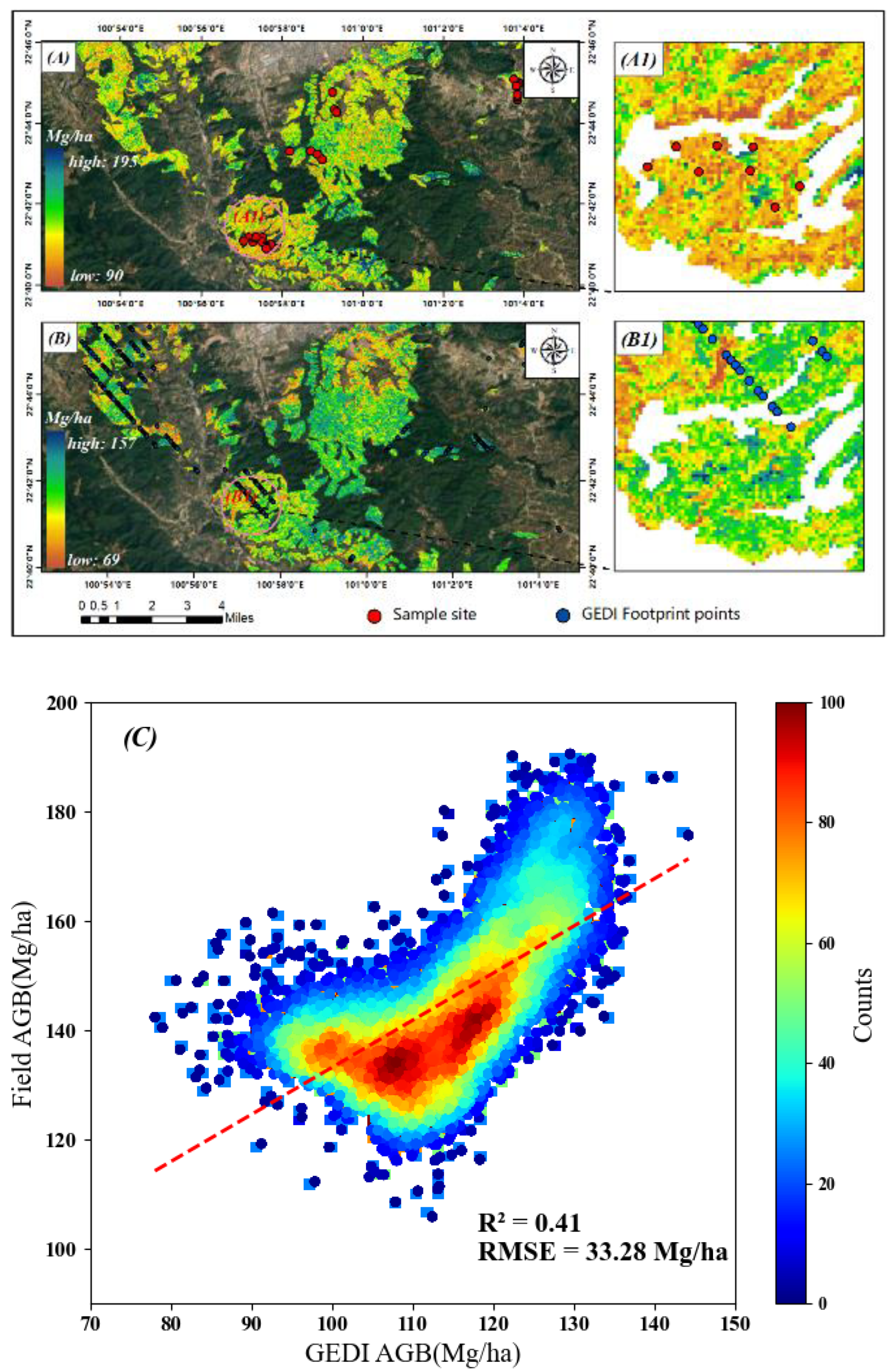
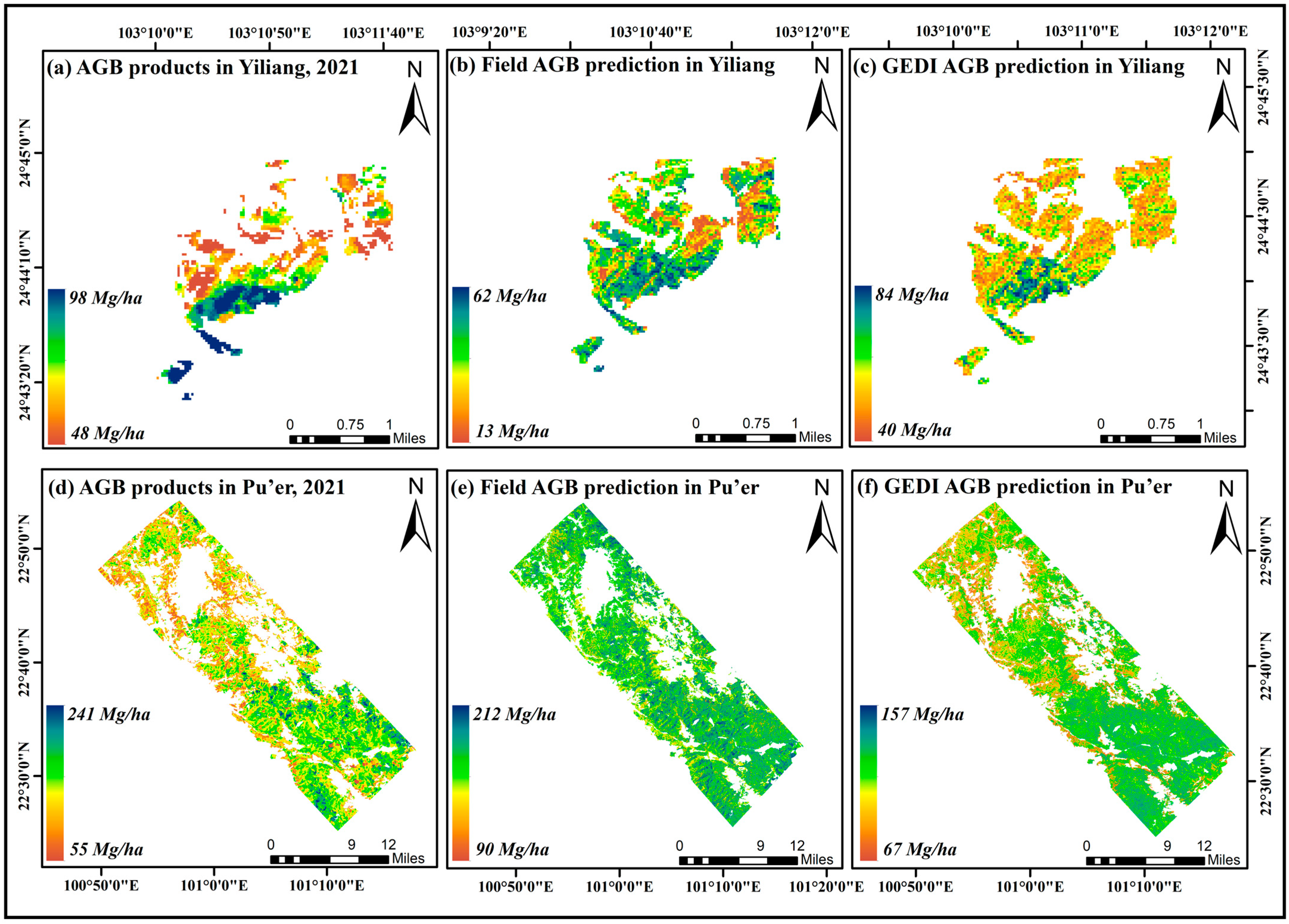
3.4. Forest AGB Mapping and Validation
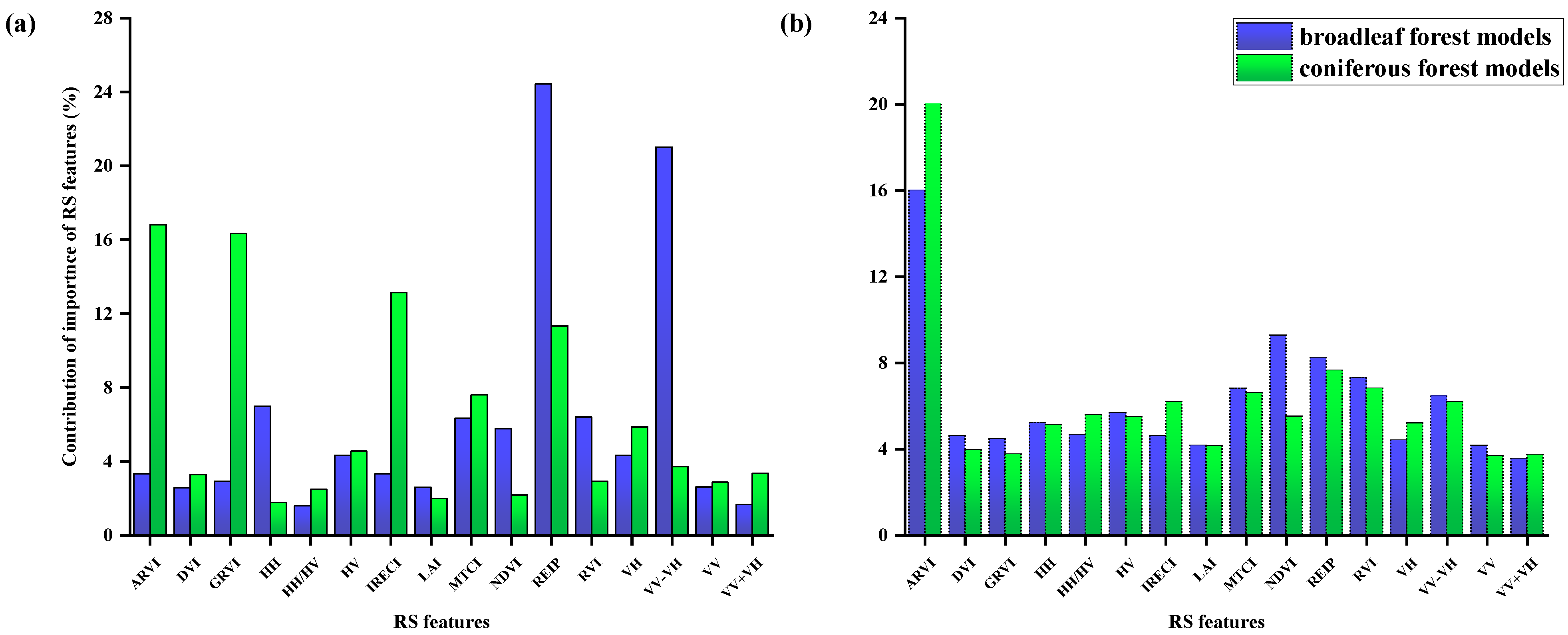
3.5. Contribution of Importance of RS Features
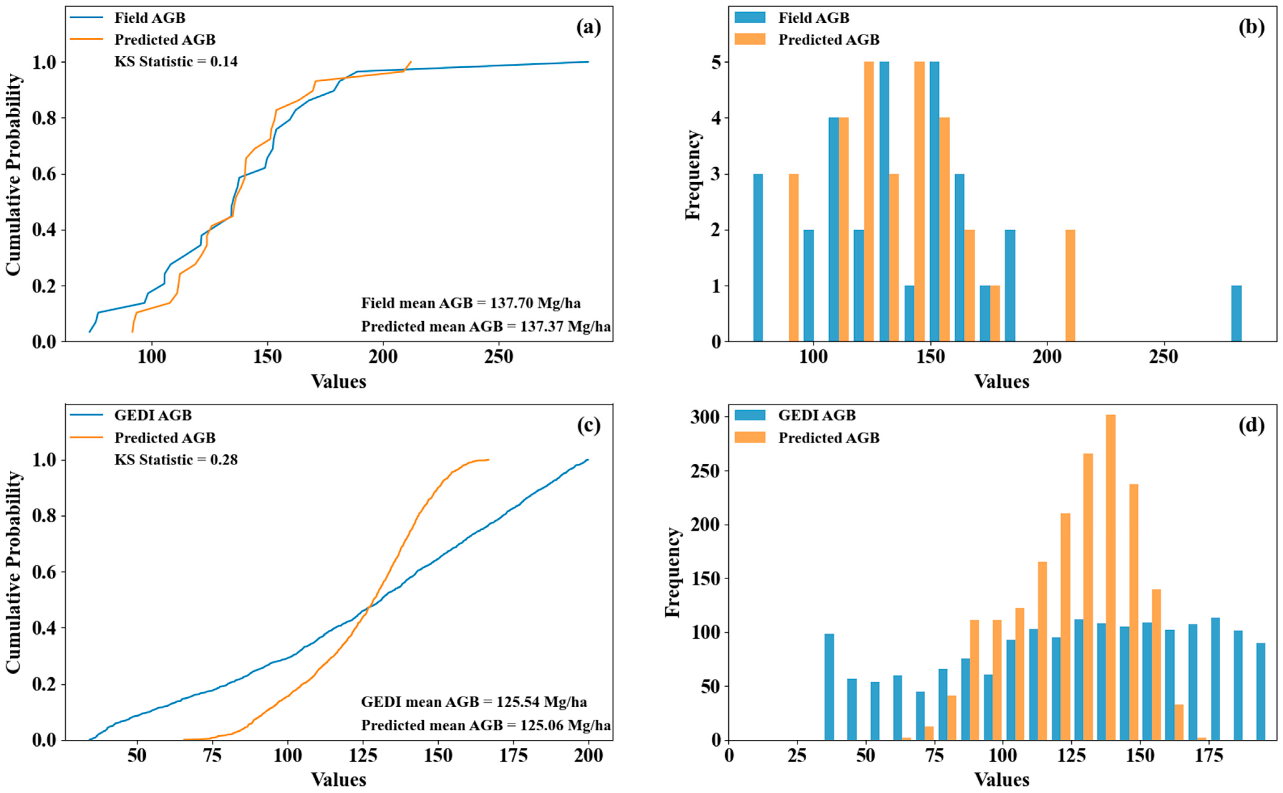
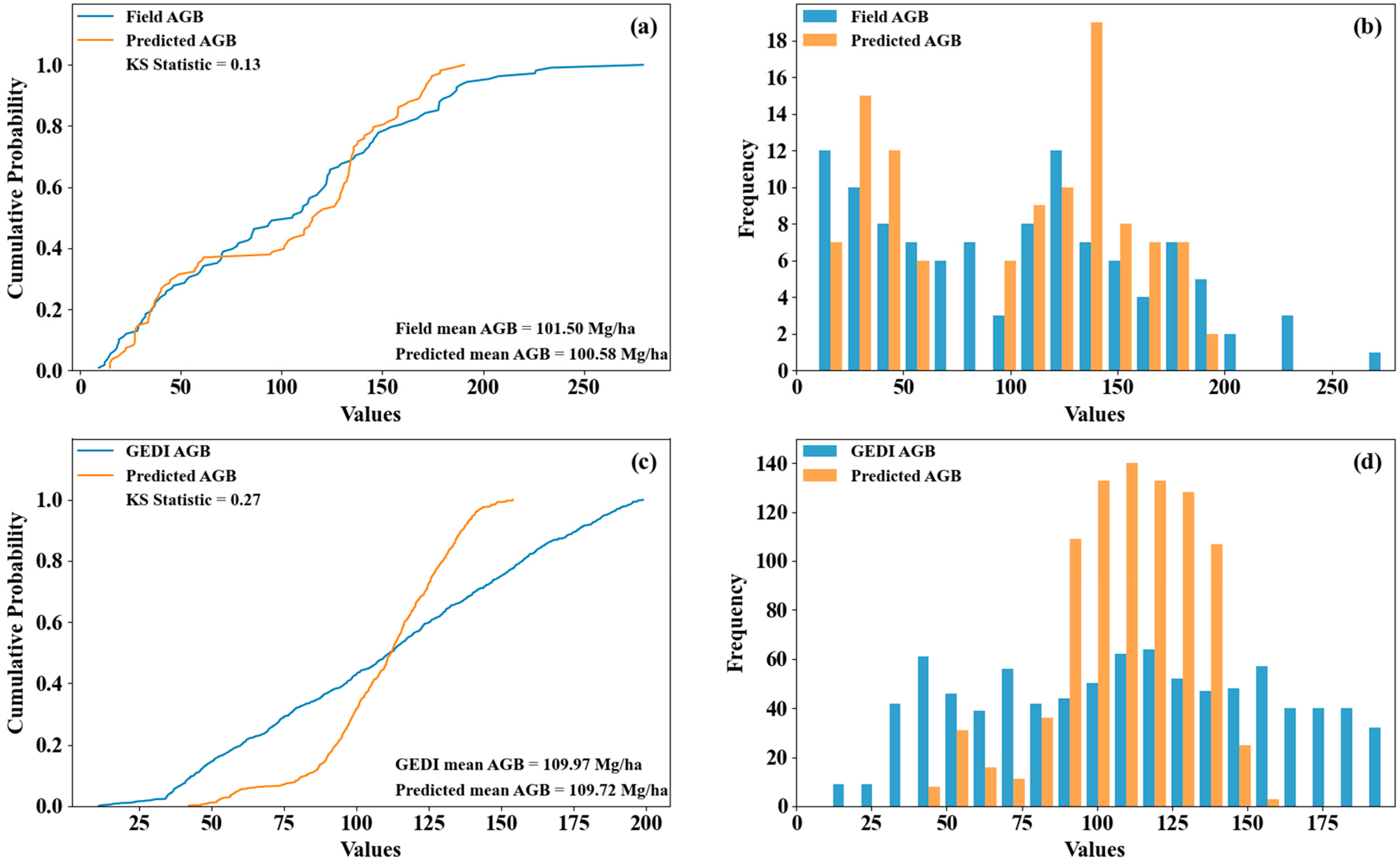
3.6. Empirical Distribution Functions of Field, GEDI, and Predicted AGB
4. Discussion
5. Conclusions
Author Contributions
Funding
Data Availability Statement
Acknowledgments
Conflicts of Interest
References
- Yang, J. Estimation of Forest Ecological and Social Benefits Based on Forest Inventory. Mod. Gard. 2022, 45, 186–188. [Google Scholar] [CrossRef]
- Wang, X. Importance of Forest Resource Conservation and Management and Analysis of Strategies. Shanxi For. Sci. Technol. 2023, 52, 61–62. [Google Scholar] [CrossRef]
- Fang, J.; Wang, G.G.; Liu, G.; Xu, S. Forest Biomass of China: An Estimate Based on the Biomass–Volume Relationship. Ecol. Appl. 1998, 8, 1084–1091. [Google Scholar] [CrossRef]
- Bolin, B. Changes of Land Biota and Their Importance for the Carbon Cycle. Science 1977, 196, 613–615. [Google Scholar] [CrossRef] [PubMed]
- Brown, S.; Lugo, A.E. Biomass of Tropical Forests: A New Estimate Based on Forest Volumes. Science 1984, 223, 1290–1293. [Google Scholar] [CrossRef]
- Brown, S.; Lugo, A.E. The Storage and Production of Organic Matter in Tropical Forests and Their Role in the Global Carbon Cycle. Biotropica 1982, 14, 161–187. [Google Scholar] [CrossRef]
- Potapov, P.; Li, X.; Hernandez-Serna, A.; Tyukavina, A.; Hansen, M.C.; Kommareddy, A.; Pickens, A.; Turubanova, S.; Tang, H.; Silva, C.E.; et al. Mapping Global Forest Canopy Height through Integration of GEDI and Landsat Data. Remote Sens. Environ. 2021, 253, 112165. [Google Scholar] [CrossRef]
- Botequim, B.; Fernandes, P.M.; Borges, J.G.; González-Ferreiro, E.; Guerra-Hernández, J.; Botequim, B.; Fernandes, P.M.; Borges, J.G.; González-Ferreiro, E.; Guerra-Hernández, J. Improving Silvicultural Practices for Mediterranean Forests through Fire Behaviour Modelling Using LiDAR-Derived Canopy Fuel Characteristics. Int. J. Wildland Fire 2019, 28, 823–839. [Google Scholar] [CrossRef]
- Narine, L.L.; Popescu, S.C.; Malambo, L. Synergy of ICESat-2 and Landsat for Mapping Forest Aboveground Biomass with Deep Learning. Remote Sens. 2019, 11, 1503. [Google Scholar] [CrossRef]
- Dobson, M.C.; Ulaby, F.T.; LeToan, T.; Beaudoin, A.; Kasischke, E.S.; Christensen, N. Dependence of Radar Backscatter on Coniferous Forest Biomass. IEEE Trans. Geosci. Remote Sens. 1992, 30, 412–415. [Google Scholar] [CrossRef]
- Lin, J.; Chen, D.; Wu, W.; Liao, X. Estimating Aboveground Biomass of Urban Forest Trees with Dual-Source UAV Acquired Point Clouds. Urban For. Urban Green. 2022, 69, 127521. [Google Scholar] [CrossRef]
- Li, L.; Zhou, X.; Chen, L.; Chen, L.; Zhang, Y.; Liu, Y. Estimating Urban Vegetation Biomass from Sentinel-2A Image Data. Forests 2020, 11, 125. [Google Scholar] [CrossRef]
- Askar, U.; Nuthammachot, N.; Phairuang, W.; Wicaksono, P.; Sayektiningsih, T. Estimating Aboveground Biomass on Private Forest Using Sentinel-2 Imagery. J. Sens. 2018, 2018, e6745629. [Google Scholar] [CrossRef]
- Han, H.; Wan, R.; Li, B. Estimating Forest Aboveground Biomass Using Gaofen-1 Images, Sentinel-1 Images, and Machine Learning Algorithms: A Case Study of the Dabie Mountain Region, China. Remote Sens. 2022, 14, 176. [Google Scholar] [CrossRef]
- Delegido, J.; Verrelst, J.; Alonso, L.; Moreno, J. Evaluation of Sentinel-2 Red-Edge Bands for Empirical Estimation of Green LAI and Chlorophyll Content. Sensors 2011, 11, 7063–7081. [Google Scholar] [CrossRef]
- Forkuor, G.; Benewinde Zoungrana, J.-B.; Dimobe, K.; Ouattara, B.; Vadrevu, K.P.; Tondoh, J.E. Above-Ground Biomass Mapping in West African Dryland Forest Using Sentinel-1 and 2 Datasets—A Case Study. Remote Sens. Environ. 2020, 236, 111496. [Google Scholar] [CrossRef]
- Nuthammachot, N.; Askar, A.; Stratoulias, D.; Wicaksono, P. Combined Use of Sentinel-1 and Sentinel-2 Data for Improving above-Ground Biomass Estimation. Geocarto Int. 2022, 37, 366–376. [Google Scholar] [CrossRef]
- Zhang, L.; Zhang, X.; Shao, Z.; Jiang, W.; Gao, H. Integrating Sentinel-1 and 2 with LiDAR Data to Estimate Aboveground Biomass of Subtropical Forests in Northeast Guangdong, China. Int. J. Digit. Earth 2023, 16, 158–182. [Google Scholar] [CrossRef]
- Shao, Z.; Zhang, L. Estimating Forest Aboveground Biomass by Combining Optical and SAR Data: A Case Study in Genhe, Inner Mongolia, China. Sensors 2016, 16, 834. [Google Scholar] [CrossRef]
- Liu, W.; Xu, C.; Zhang, Z.; De Boeck, H.; Wang, Y.; Zhang, L.; Xu, X.; Zhang, C.; Chen, G.; Xu, C. Machine Learning-Based Grassland Aboveground Biomass Estimation and Its Response to Climate Variation in Southwest China. Front. Ecol. Evol. 2023, 11, 1146850. [Google Scholar] [CrossRef]
- Tu, H.; Ma, G.; Pan, Z.; Li, H.; Zhang, R.; Yao, X. Assessment of Forest Ecosystem Service Function Value in Yunnan Province. Guangxi For. Sci. 2023, 52, 23–30. [Google Scholar] [CrossRef]
- Peng, J.; Zhu, K.; Xu, H.; Huang, X.; Dai, J.; Huang, R. Exploring the Development of Highland Mountain Forest Cities in Yunnan Province. For. Resour. Manag. 2021, 23–29. [Google Scholar] [CrossRef]
- Hu, Z. Analysis and Evaluation of Dynamic Changes of Forest Resources in Yunnan Province. For. Surv. Plan. 2017, 42, 87–94+99. [Google Scholar]
- Meng, X. Forest Mensuration; China Forestry Publishing House: Beijing, China, 2006. [Google Scholar]
- Luo, Y.; Wang, X.; Lu, F. Comprehensive Database of Biomass Regressions for China’s Tree Species; China Forestry Publishing House: Beijing, China, 2015. [Google Scholar]
- Xu, H.; Zhang, H. Forest Tree Biomass Modeling; Yunnan Science and Technology Press: Kunming, China, 2002. [Google Scholar]
- Shimada, M.; Itoh, T.; Motooka, T.; Watanabe, M.; Shiraishi, T.; Thapa, R.; Lucas, R. New Global Forest/Non-Forest Maps from ALOS PALSAR Data (2007–2010). Remote Sens. Environ. 2014, 155, 13–31. [Google Scholar] [CrossRef]
- Xue, J.; Su, B. Significant Remote Sensing Vegetation Indices: A Review of Developments and Applications. J. Sens. 2017, 2017, e1353691. [Google Scholar] [CrossRef]
- Xi, Z.; Xu, H.; Xing, Y.; Gong, W.; Chen, G.; Yang, S. Forest Canopy Height Mapping by Synergizing ICESat-2, Sentinel-1, Sentinel-2 and Topographic Information Based on Machine Learning Methods. Remote Sens. 2022, 14, 364. [Google Scholar] [CrossRef]
- Bhattarai, R.; Rahimzadeh-Bajgiran, P.; Weiskittel, A.; MacLean, D.A. Sentinel-2 Based Prediction of Spruce Budworm Defoliation Using Red-Edge Spectral Vegetation Indices. Remote Sens. Lett. 2020, 11, 777–786. [Google Scholar] [CrossRef]
- Vesanto, V.-H.; Mõttus, M.; Heiskanen, J.; Rautiainen, M.; Majasalmi, T. Atmospheric Correction of a Seasonal Time Series of Hyperion EO-1 Images and Red Edge Inflection Point Calculation. In Proceedings of the 2012 4th Workshop on Hyperspectral Image and Signal Processing: Evolution in Remote Sensing (WHISPERS), Shanghai, China, 4–7 June 2012; pp. 1–4. [Google Scholar]
- Puliti, S.; Breidenbach, J.; Schumacher, J.; Hauglin, M.; Klingenberg, T.F.; Astrup, R. Above-Ground Biomass Change Estimation Using National Forest Inventory Data with Sentinel-2 and Landsat. Remote Sens. Environ. 2021, 265, 112644. [Google Scholar] [CrossRef]
- Kellner, J.R.; Armston, J.; Duncanson, L. Algorithm Theoretical Basis Document for GEDI Footprint Aboveground Biomass Density. Earth Space Sci. 2023, 10, e2022EA002516. [Google Scholar] [CrossRef]
- Shams, M.Y.; Elshewey, A.M.; El-kenawy, E.-S.M.; Ibrahim, A.; Talaat, F.M.; Tarek, Z. Water Quality Prediction Using Machine Learning Models Based on Grid Search Method. In Multimedia Tools and Applications; Springer: Berlin/Heidelberg, Germany, 2023. [Google Scholar] [CrossRef]
- Zhang, Y.; Ma, J.; Liang, S.; Li, X.; Li, M. An Evaluation of Eight Machine Learning Regression Algorithms for Forest Aboveground Biomass Estimation from Multiple Satellite Data Products. Remote Sens. 2020, 12, 4015. [Google Scholar] [CrossRef]
- Jiang, F.; Sun, H.; Ma, K.; Fu, L.; Tang, J. Improving Aboveground Biomass Estimation of Natural Forests on the Tibetan Plateau Using Spaceborne LiDAR and Machine Learning Algorithms. Ecol. Indic. 2022, 143, 109365. [Google Scholar] [CrossRef]
- Moradi, F.; Darvishsefat, A.A.; Pourrahmati, M.R.; Deljouei, A.; Borz, S.A. Estimating Aboveground Biomass in Dense Hyrcanian Forests by the Use of Sentinel-2 Data. Forests 2022, 13, 104. [Google Scholar] [CrossRef]
- McRoberts, R.E.; Tomppo, E.O. Remote Sensing Support for National Forest Inventories. Remote Sens. Environ. 2007, 110, 412–419. [Google Scholar] [CrossRef]
- Shataee, S.; Kalbi, S.; Fallah, A.; Pelz, D. Forest Attribute Imputation Using Machine-Learning Methods and ASTER Data: Comparison of k-NN, SVR and Random Forest Regression Algorithms. Int. J. Remote Sens. 2012, 33, 6254–6280. [Google Scholar] [CrossRef]
- Gao, Y.; Lu, D.; Li, G.; Wang, G.; Chen, Q.; Liu, L.; Li, D. Comparative Analysis of Modeling Algorithms for Forest Aboveground Biomass Estimation in a Subtropical Region. Remote Sens. 2018, 10, 627. [Google Scholar] [CrossRef]
- Kanmegne Tamga, D.; Latifi, H.; Ullmann, T.; Baumhauer, R.; Bayala, J.; Thiel, M. Estimation of Aboveground Biomass in Agroforestry Systems over Three Climatic Regions in West Africa Using Sentinel-1, Sentinel-2, ALOS, and GEDI Data. Sensors 2023, 23, 349. [Google Scholar] [CrossRef]
- Pal, M. Random Forest Classifier for Remote Sensing Classification. Int. J. Remote Sens. 2005, 26, 217–222. [Google Scholar] [CrossRef]
- Fassnacht, F.E.; Hartig, F.; Latifi, H.; Berger, C.; Hernández, J.; Corvalán, P.; Koch, B. Importance of Sample Size, Data Type and Prediction Method for Remote Sensing-Based Estimations of Aboveground Forest Biomass. Remote Sens. Environ. 2014, 154, 102–114. [Google Scholar] [CrossRef]
- Latifi, H.; Nothdurft, A.; Koch, B. Non-Parametric Prediction and Mapping of Standing Timber Volume and Biomass in a Temperate Forest: Application of Multiple Optical/LiDAR-Derived Predictors. For. Int. J. For. Res. 2010, 83, 395–407. [Google Scholar] [CrossRef]
- Silva, C.A.; Duncanson, L.; Hancock, S.; Neuenschwander, A.; Thomas, N.; Hofton, M.; Fatoyinbo, L.; Simard, M.; Marshak, C.Z.; Armston, J.; et al. Fusing Simulated GEDI, ICESat-2 and NISAR Data for Regional Aboveground Biomass Mapping. Remote Sens. Environ. 2021, 253, 112234. [Google Scholar] [CrossRef]
- Campbell, M.J.; Dennison, P.E.; Kerr, K.L.; Brewer, S.C.; Anderegg, W.R.L. Scaled Biomass Estimation in Woodland Ecosystems: Testing the Individual and Combined Capacities of Satellite Multispectral and Lidar Data. Remote Sens. Environ. 2021, 262, 112511. [Google Scholar] [CrossRef]
- Shendryk, Y. Fusing GEDI with Earth Observation Data for Large Area Aboveground Biomass Mapping. Int. J. Appl. Earth Obs. Geoinf. 2022, 115, 103108. [Google Scholar] [CrossRef]
- Lu, D.; Chen, Q.; Wang, G.; Liu, L.; Li, G.; Moran, E. A Survey of Remote Sensing-Based Aboveground Biomass Estimation Methods in Forest Ecosystems. Int. J. Digit. Earth 2016, 9, 63–105. [Google Scholar] [CrossRef]
- Lone, J.M.; Sivasankar, T.; Pebam, R.; Sarma, K.K.; Qadir, M.A.; Raju, P.L.N. Comparison of C-Band Sentinel-1 and L-Band ALOSPALSAR-2 Data for Aboveground Forest Biomass Estimation over Nongkhyllem Forest Reserve and Wildlife Sanctuary, Meghalaya, India. In Proceedings of the Advances in Remote Sensing & GIS Applications, North Eastern Space Applications Centre, Umiam, Meghalaya, India, 10–11 May 2018. [Google Scholar]
- Pandit, S.; Tsuyuki, S.; Dube, T. Estimating Above-Ground Biomass in Sub-Tropical Buffer Zone Community Forests, Nepal, Using Sentinel 2 Data. Remote Sens. 2018, 10, 601. [Google Scholar] [CrossRef]
- Laurin, G.V.; Balling, J.; Corona, P.; Mattioli, W.; Papale, D.; Puletti, N.; Rizzo, M.; Truckenbrodt, J.; Urban, M. Above-Ground Biomass Prediction by Sentinel-1 Multitemporal Data in Central Italy with Integration of ALOS2 and Sentinel-2 Data. J. Appl. Remote Sens. 2018, 12, 016008. [Google Scholar] [CrossRef]
- Zeng, P.; Zhang, W.; Li, Y.; Shi, J.; Wang, Z. Forest Total and Component Above-Ground Biomass (AGB) Estimation through C- and L-Band Polarimetric SAR Data. Forests 2022, 13, 442. [Google Scholar] [CrossRef]
- Horler, D.N.H.; Dockray, M.; Barber, J.; Barringer, A.R. Red Edge Measurements for Remotely Sensing Plant Chlorophyll Content. Adv. Space Res. 1983, 3, 273–277. [Google Scholar] [CrossRef]
- Vaglio Laurin, G.; Chen, Q.; Lindsell, J.A.; Coomes, D.A.; Frate, F.D.; Guerriero, L.; Pirotti, F.; Valentini, R. Above Ground Biomass Estimation in an African Tropical Forest with Lidar and Hyperspectral Data. ISPRS J. Photogramm. Remote Sens. 2014, 89, 49–58. [Google Scholar] [CrossRef]
- Araza, A.; de Bruin, S.; Herold, M.; Quegan, S.; Labriere, N.; Rodriguez-Veiga, P.; Avitabile, V.; Santoro, M.; Mitchard, E.T.A.; Ryan, C.M.; et al. A Comprehensive Framework for Assessing the Accuracy and Uncertainty of Global Above-Ground Biomass Maps. Remote Sens. Environ. 2022, 272, 112917. [Google Scholar] [CrossRef]
- Zomer, R.J.; Bossio, D.A.; Trabucco, A.; van Noordwijk, M.; Xu, J.; Zomer, R.J.; Bossio, D.A.; Trabucco, A.; van Noordwijk, M.; Xu, J. Global Carbon Sequestration Potential of Agroforestry and Increased Tree Cover on Agricultural Land. Circ. Agric. Syst. 2022, 2, 3. [Google Scholar] [CrossRef]
- Fayad, I.; Baghdadi, N.; Alcarde Alvares, C.; Stape, J.L.; Bailly, J.S.; Scolforo, H.F.; Cegatta, I.R.; Zribi, M.; Le Maire, G. Terrain Slope Effect on Forest Height and Wood Volume Estimation from GEDI Data. Remote Sens. 2021, 13, 2136. [Google Scholar] [CrossRef]
- Wang, Y.; Ni, W.; Sun, G.; Chi, H.; Zhang, Z.; Guo, Z. Slope-Adaptive Waveform Metrics of Large Footprint Lidar for Estimation of Forest Aboveground Biomass. Remote Sens. Environ. 2019, 224, 386–400. [Google Scholar] [CrossRef]
- Li, M.; Qu, J.J.; Hao, X. Estimating Aboveground Biomass for Different Forest Types Based on Landsat TM Measurements. In Proceedings of the 2009 17th International Conference on Geoinformatics, Fairfax, VA, USA, 12–14 August 2009; pp. 1–6. [Google Scholar]
- Li, Y.; Li, C.; Li, M.; Liu, Z. Influence of Variable Selection and Forest Type on Forest Aboveground Biomass Estimation Using Machine Learning Algorithms. Forests 2019, 10, 1073. [Google Scholar] [CrossRef]
- Saarela, S.; Holm, S.; Healey, S.P.; Andersen, H.-E.; Petersson, H.; Prentius, W.; Patterson, P.L.; Næsset, E.; Gregoire, T.G.; Ståhl, G. Generalized Hierarchical Model-Based Estimation for Aboveground Biomass Assessment Using GEDI and Landsat Data. Remote Sens. 2018, 10, 1832. [Google Scholar] [CrossRef]
- Yan, S.; He, G.; Zhang, X. Forest Aboveground Biomass Products in China, 2013–2021. Sci. Data Bank 2023, 118, 103275. [Google Scholar] [CrossRef]


| Study Area | Forest Type | Number of Plots | AGB (Mg/ha) | Average AGB (Mg/ha) | Average Crown Cover (%) |
|---|---|---|---|---|---|
| Pu’er | Coniferous forest | 27 | 69.61–162.30 | 120.89 | 70.00 |
| Broadleaf forest | 31 | 73.26–288.68 | 141.68 | 75.46 | |
| Yiliang | Coniferous forest | 40 | 9.34–78.51 | 36.13 | 63.00 |
| Tree Species | Biomass Model |
|---|---|
| Simao Pine (Pinus kesiya) | |
| Chinese Gugertree (Schima superba) | |
| Farges’s Chinkapin (Castanopsis fargesii) | |
| Blue Gum (Eucalyptus globulus) | |
| Weeping Cypress (Cupressus funebris) | |
| Chinese Fir (Cunninghamia lanceolata) | |
| Other broadleaf species | |
| Yunnan Pine (Pinus yunnanensis) | ; |
| Variable Type | Variable Name | Definition |
|---|---|---|
| Polarization Information | VV, VH | Backscatter coefficients from S1 |
| HH, HV | Backscatter coefficients PALSAR-2 | |
| Constructed features | VV-VH | Polarization Difference |
| VH+VV | Polarization Sum | |
| HH/HV | Polarization Ratio |
| Vegetation Index | Calculation Formula | Reference |
|---|---|---|
| Normalized difference vegetation index (NDVI) | [28] | |
| Green and red vegetation index (GRVI) | [28] | |
| Leaf area index (LAI) | [29] | |
| Differential vegetation index (DVI) | [28] | |
| Infrared-red enhanced vegetation index (IRECI) | [30] | |
| Ratio vegetation index (RVI) | [28] | |
| MERIS terrestrial chlorophyll index (MTCI) | [30] | |
| Atmospheric resistance vegetation index (ARVI) | [28] | |
| Red-edge inflection point index (REIP) | [31] |
Disclaimer/Publisher’s Note: The statements, opinions and data contained in all publications are solely those of the individual author(s) and contributor(s) and not of MDPI and/or the editor(s). MDPI and/or the editor(s) disclaim responsibility for any injury to people or property resulting from any ideas, methods, instructions or products referred to in the content. |
© 2024 by the authors. Licensee MDPI, Basel, Switzerland. This article is an open access article distributed under the terms and conditions of the Creative Commons Attribution (CC BY) license (https://creativecommons.org/licenses/by/4.0/).
Share and Cite
Wang, C.; Zhang, W.; Ji, Y.; Marino, A.; Li, C.; Wang, L.; Zhao, H.; Wang, M. Estimation of Aboveground Biomass for Different Forest Types Using Data from Sentinel-1, Sentinel-2, ALOS PALSAR-2, and GEDI. Forests 2024, 15, 215. https://doi.org/10.3390/f15010215
Wang C, Zhang W, Ji Y, Marino A, Li C, Wang L, Zhao H, Wang M. Estimation of Aboveground Biomass for Different Forest Types Using Data from Sentinel-1, Sentinel-2, ALOS PALSAR-2, and GEDI. Forests. 2024; 15(1):215. https://doi.org/10.3390/f15010215
Chicago/Turabian StyleWang, Chu, Wangfei Zhang, Yongjie Ji, Armando Marino, Chunmei Li, Lu Wang, Han Zhao, and Mengjin Wang. 2024. "Estimation of Aboveground Biomass for Different Forest Types Using Data from Sentinel-1, Sentinel-2, ALOS PALSAR-2, and GEDI" Forests 15, no. 1: 215. https://doi.org/10.3390/f15010215
APA StyleWang, C., Zhang, W., Ji, Y., Marino, A., Li, C., Wang, L., Zhao, H., & Wang, M. (2024). Estimation of Aboveground Biomass for Different Forest Types Using Data from Sentinel-1, Sentinel-2, ALOS PALSAR-2, and GEDI. Forests, 15(1), 215. https://doi.org/10.3390/f15010215