Article

A Comparison of Mangrove Forest Structure and Ecosystem Services in Maputo Bay (Eastern Africa) and Príncipe Island (Western Africa)

1
Department of Biological Sciences, Eduardo Mondlane University, P.O. Box 257, Maputo 1100, Mozambique
2
United States Forest Service, International Programs, 1 Thomas Circle NW, Suite 400, Washington, DC 20005, USA
3
Mare–Marine and Environmental Sciences Centre, Faculty of Sciences, University of Lisbon, Campo Grande, 1749-016 Lisbon, Portugal
4
Reserva da Biosfera e Parque Natural do Príncipe, Praça do Poeta Marcelo da Veiga, Príncipe Island, Gulf of Guinea 311, Sao Tome and Principe
*
Author to whom correspondence should be addressed.
Forests 2022, 13(9), 1466; https://doi.org/10.3390/f13091466
Submission received: 5 August 2022 / Revised: 23 August 2022 / Accepted: 2 September 2022 / Published: 12 September 2022
(This article belongs to the Section Forest Ecology and Management)

Abstract

:
Mangroves are critical to maintaining human well-being and global biodiversity. Eastern and western African shores present major environmental contrasts that reflect on mangrove forests’ structure and the ecosystem services they provide to human communities. This study compares the mangrove forest structure and condition, ecosystem services, and uses of resources in Maputo Bay (Mozambique in eastern Africa) and Príncipe Island (São Tomé and Príncipe in western Africa). Five mangrove species were identified in Maputo Bay, Avicennia marina, Bruguiera gymnorhiza, Ceriops tagal, Rhizophora mucronata, and Xylocarpus granatum, and the importance value index was higher for A. marina. Mangroves in Príncipe were exclusively dominated by Rhizophora harrisonii. In Maputo Bay, a weak regeneration characterized by a low quantity of seedlings was observed, although in Príncipe the sites were characterized by a low regeneration rate but well-established forests. The comparison of the mangrove structure between Maputo Bay and Príncipe Island presented statistically significant differences for mean DBH and height, whereas the trees in Príncipe presented higher values for both parameters. Strong human disturbance (through cutting) was identified in almost all sites in Maputo Bay but was rarely observed on Príncipe Island. In Maputo Bay, more than 90% of the coastal human community is involved in activities related to the surrounding mangroves, with a diversified exploitation of forest resources. On Príncipe Island, the exploitation of mangroves targets only tannin from the mangrove bark to dye fishing nets and small boats. The economic value of mangroves in Maputo Bay has subsistence and commercial importance, in contrast to Príncipe, which revealed no major economic value to the community.

1. Introduction

Coastal ecosystems, including mangrove forests, tidal salt marshes, and seagrass meadows are critical to maintaining human well-being and global biodiversity [1,2,3,4]. Economically, mangrove forests provide very diverse and valuable products to coastal communities at the local, regional, and global levels. Some of the provisioning ecosystem services consist of wood products (e.g., timber, poles, firewood, and charcoal) and nonwooden products (salt production, tannins, beekeeping for honey production, fisheries, aquaculture, medicine, cultural and aesthetic values) [2,5,6].
Mangroves are a taxonomically diverse group of salt-tolerant, mainly arboreal [7], intertidal communities of trees and shrubs distributed worldwide in tropical and subtropical coastal regions [1,2,8]. These plants developed specialized adaptations to live in the intertidal environment, which has variable salinity and tidally driven inundation, strong winds, anaerobic mineral, and organic soils [2,3,9]. The adaptations include unique structural, morphological, and reproductive specializations, such as aerial root systems (pneumatophores), salt-extracting leaves, and viviparous water-dispersed propagules [3].
Ecologically, mangroves support soil formation, photosynthesis, primary production, carbon storage, provision of habitat for fishery nurseries, birds, and nutrient export [10,11]. Mangroves also regulate various ecological processes, such as biological control, coastal protection, nutrient cycling, water quality regulation, erosion, wave attenuation, sediment accretion, and the maintenance of biodiversity [1,10,11].
Mangrove forests are distributed within the tropics and subtropics, reaching their maximum development between 25° N and 25° S [5,7]. On the regional and local scales, variations in rainfall, tides, waves, and river flows have a substantial effect on the distribution, diversity, and biomass of mangrove forests [12,13]. Temperature is also an important limiting factor of mangrove distribution, emphasizing the importance of studying mangroves due to climate change. There are 13,776,000 ha of mangroves distributed in 118 countries worldwide [2,14,15], representing 0.7% of the world’s total forests [2]. Approximately 75% of mangroves are concentrated in 15 countries, and Mozambique occupies the 13th position in the ranking [2,14].
The southwest and southeast African coasts have strong environmental contrasts. The Mozambique Channel and Agulhas currents push the warm tropical environments to higher latitudes in the southwestern Indian Ocean, while the Benguela current drives cool water to the north in the southeastern Atlantic, compressing the tropical region. The biodiversity is much higher in the Indian Ocean when compared to the Atlantic, including the mangrove species’ richness [15,16], thus, causing different forest structures. Ecosystem services and human uses of the mangrove forest’s resources also relate to biological diversity and forest structure, and are, thus, expected to differ on both sides of the African continent. There is hardly any comparative analysis of mangrove forest structures and the services they provide to human populations on both sides of the African continent.
In Maputo Bay, mangroves occupy an area of approximately 18,000 ha concentrated on the estuarine areas of five rivers: Incomati, Maputo, Tembe, Umbeluzi, and Matola [17,18,19]. Out of the nine mangrove species in Mozambique, six can be found in Maputo Bay, namely, Avicennia marina (Forssk.) Vierh., Rhizophora mucronata Poir., Bruguiera gymnorhiza (L.) Lamk., Ceriops tagal (Perr.) C.B. Robinson, Lumnitzera racemosa Willd., and Xylocarpus grannatum J.Keonig [20,21,22].
In São Tomé and Príncipe, the mangrove forests cover approximately 100–136 ha [15,16]; however; recent estimates confirm at least double that area on São Tomé Island only [23]. On Príncipe Island, mangroves occupy a small area of approximately 1.6 ha, scattered along three major watercourses that discharge at the beaches of Praia Salgada, Praia Grande, and Praia Caixão. The mangroves are exclusively composed of the species Rhizophora harrisonii Leechm. [24,25].
The ecosystem services (ES) are poorly documented for both regions. In Maputo Bay, the documentation of ES is scarce, although the described exploitation of ES is considered to contribute to mangrove degradation [26,27]. Afonso et al. [23] recently documented mangrove ES on São Tomé Island, including perceptions of mangrove values and threats [28], highlighting over 20 ES, altogether covering provisioning, regulation, and cultural and supporting services. Overall, it is expected that both locations present significant differences in the ES provided and the usage of resources, partially derived from the contrasting characteristics of their forest structures. On the other hand, it is also expected that more intensive exploitation may correspond to higher mangrove degradation and altered forest structure.
This study envisages comparing the mangroves between two contrasting areas: Maputo Bay (Mozambique) on the east coast of Africa, and Príncipe Island (São Tomé and Príncipe) on the west coast of Africa, focusing on: (1) the mangrove structure and ecosystem services; (2) the traditional uses of mangrove ecosystems and related socioeconomy, with particular focus on the identification and description of goods and services derived from mangrove forests; and (3) the income of different stakeholders and the socioeconomic sustainability of mangrove utilization.

2. Materials and Methods
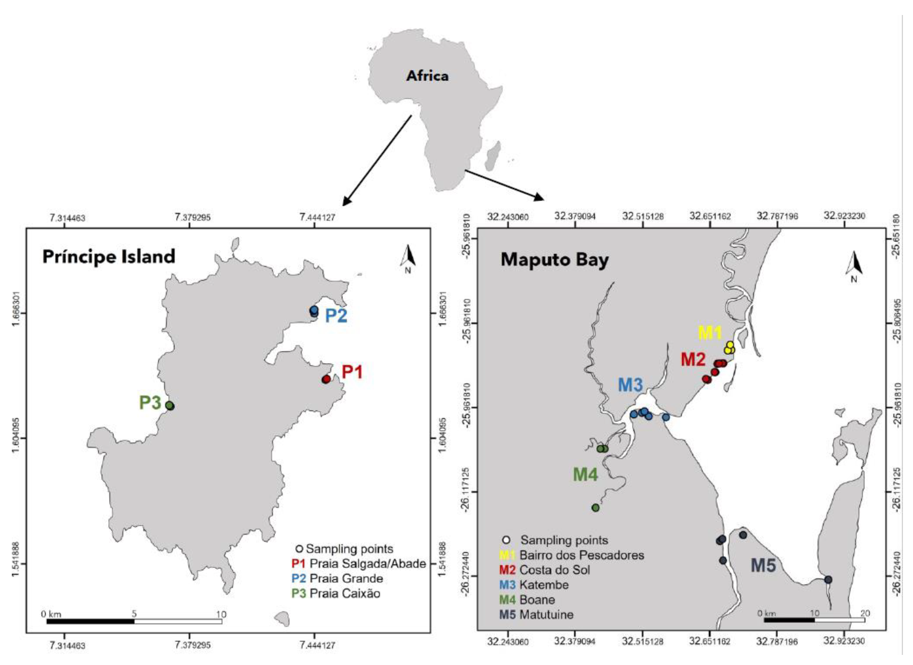
2.1. Study Area

This study was conducted in two study areas: Maputo Bay (Mozambique) and Príncipe Island (São Tomé and Principe) (Figure 1).

2.1.1. Maputo Bay

Maputo Bay is located in southern Mozambique between the coordinates 25°55′ S to 26°10′ S and 32°40′ E to 32°55′ E [29,30]. It is one of the largest bays in eastern Africa with 1 280 km2. It receives the discharge of five rivers and has extensive mangrove forests, occupying an area of 176 km2 [31]. The Bay is bordered by Inhaca Island, Portuguese Island, and Machangulo Península to the east and opens to the Indian Ocean to the northeast [32]. The north-western part is bordered by the Incomati Estuary [26], the western part by Maputo City, Katembe District, and the Espírito Santo Estuary.
The climate in the region is subtropical with two seasons, winter from April to September and rainy summer extends from October to March. The daytime air temperature in the wet season can reach 40 °C while in the dry season the temperature can reach 28 °C [30].
Precipitation varies between 34.7–211.9 mm in the wet season and 7.7–77.3 mm in the dry season [18] with an annual average of approximately 884 mm [33], the humidity ranges from 50% to 82% [29] and salinity from 30 to 39 with an annual average of 35 [26].
Maputo Bay is ecologically important and one of the largest fisheries production areas in the country [13,34,35]. The extensive mangroves and the shallow water bay characteristics (10 m average water depth) contribute to the productive fishing area [17].
This study was conducted in five mangrove areas in Maputo Bay: Bairro dos Pescadores, Costa do Sol, Katembe, Boane, and Matutuine (Figure 1).

2.1.2. Príncipe Island

São Tomé and Príncipe, located at the equator in the Gulf of Guinea (0°25′ N; 6°20′ E), nearly 400 km of continental western Africa, is a volcanic archipelago of two main islands with a total area of 1001 km2, of which Príncipe has 142 km2. These islands have a rather uniform vegetation dominated by rain forests [36], being complemented with small portions of mangrove areas, coastal sand, and rocky shores [37].
The country has tropical humid climate, with four climatic seasons, alternating between rainier and dryer phases with different intensities. The main dry season is called ‘gravana’, which occurs between July and September [38,39]. The second dry season is less pronounced and occurs between January and March [38]. The two rainy seasons are between October and December, and April–June, is the first most intense season [16]. The average annual rainfall ranges from 2000 to 3000 mm, reaching 7000 mm over the cloud forests [38,40]. Temperatures range 18–21 °C minimum and 30–35 °C maximum [24] and with an annual average of 26 °C [40]. The air relative humidity is very high, reaching more than 90% at higher altitudes [40].
This study was conducted in the three mangrove areas on Príncipe Island: Praia Salgada, located in Abade Bay, Praia Grande Norte, and Praia Caixão (Figure 1).

2.2. Methods

2.2.1. Forest Structure Characterization

Both in Maputo Bay (Costa do Sol, Bairro dos Pescadores, Katembe, Boane, and Matutuíne) and Príncipe Island (Praia Salgada, Praia Grande, and Praia Caixão) we established random sampling plots. The total number of individual trees (N) and plots (Q) for each sampled area in Maputo Bay (N = 1218, Q = 40) and Príncipe Island (N = 263, Q = 11) were assessed. Each plot had an area of 100 m2 (10 m × 10 m) and methodologies followed standard field protocols [4,41,42,43]. In each plot we assessed species composition and forest structure parameters, such as species identity, number of live/dead trees, trees’ height, respective diameter at breast height (DBH), and height and density of stumps [44].

2.2.2. In-Depth Interviews with Community Members and Local Authorities

The local communities were consulted through in-depth interviews (using semi-structured questionnaires) in order to assess their level of awareness about the importance of the mangrove ecosystem for their livelihoods. The intentional sampling technique [45,46] was used for the selection of stakeholders for the interview, based on the nominations made by key informants; this included local government personnel and the local leaders, based on the premise that they have deep knowledge of the activities within the study area, which will help in the selection of the people who would participate in the interviews [45].
The interviews were conducted individually and in groups (focus group discussions, FGD). The group discussions consisted of 6–12 people, disaggregated by gender (male and female), age groups, and other relevant socioeconomic characteristics [45,46]. We assume that socioeconomic characteristics are important factors that can determine the types of activities and products exploited in the mangrove ecosystem, as well as their relationship with the mangrove area [47,48]. Individual interviews were also conducted to facilitate inclusion in the group of interest, which otherwise were not willing to talk at the group meetings.
The interviews were performed with mangrove users, local administrative entities and groups of inhabitants living near the mangrove [47,48,49,50]. This approach allowed a better understanding of the local communities’ livelihoods and their knowledge about the mangrove importance. All interviewees as part of the study received a verbal statement explaining the purpose of the study. These interviews were held in places where members of the community felt free to do so [45,46].

2.2.3. Data Treatment

The analysis of the structure data was carried out using the statistical programs Stata Statistical Software: Release 10. College Station, TX: StataCorp LP.and IBM SPSS Statistics for Windows, Version 25.0. Armonk, NY: IBM Corp.. Normality tests Shapiro-Wilk (1965) were applied to all quantitative data (DBH (cm), height (m), and density (ind/ha), to determine stem quality, tree condition, and regeneration. Through this test, the data that proved to be parametric were submitted to ANOVA for comparison tests, and the nonparametric ones were compared through the Kruskal–Wallis test, corresponding to the ANOVA test for nonparametric data. Treatment for socioeconomic data were performed with IBM SPSS Statistics for Windows, Version 25.0. Armonk, NY, USA: IBM Corp.

3. Results

3.1. Study Area Characterization

Mangroves across the Maputo Bay are very similar in terms of forest structure and are mostly dominated by A. marina, which is often shrubby or dwarfed and generally low in density. On Príncipe Island, the mangrove forests present the same uniformity, and are mainly basin and riverine forests; the soil composition is dominated by sand/clay, except for the mangroves in Praia Grande, where the soil is mostly peat or clay. The characterization of the study areas revealed a variation in the characteristics of the soil, inundation classes, and the type of forest in the study areas (Table 1).
The inundation classes described in Table 1 refer to the cumulative classes that are identified at each sampling area that have an influence on a specific sampling plot. At Príncipe Island, only one inundation class that had influence in all sampled plots was identified.
During the characterization of the areas in Maputo Bay, we observed a weak regeneration characterized by the low quantity of seedlings, the presence of garbage and other materials discarded, and the presence of deposits very close to the mangroves, especially at Costa do Sol. Transformation of certain places for housing by cutting down mangrove trees and land claims was also observed, both at Costa do Sol and Bairro dos Pescadores. Human interference (through cutting) was identified in almost all sites in Maputo Bay, which shows its importance to local communities. In some places, such anthropogenic interference was very pronounced, including land use change (due to urban expansion) and solid waste disposal. However, well-established forest patches were also found, with greater species diversity and a more robust forest structure.
On Príncipe Island, during the fieldwork, many dead trees and some signs of tree pealing for tannin and bark extraction were observed at Praia Caixão. Only one species of Atlantic mangrove was identified, Rhizophora harrisonii, which was not seen in Maputo Bay (or in any other forest in Mozambique). All the sites were characterized by low regeneration rates and well-established forests, with trees with high heights varying from 8.72 m to 12.24 m compared to Maputo Bay, where tree height varied from 1.24 m to 2.50 m. Low signs of cutting were observed, especially at Praia Grande.

3.2. Forest Structure

In different locations within Maputo Bay, the number of species varied, four at Bairro dos Pescadores, Katembe, and Matutuíne (A. marina, B. gymnorhiza, C. tagal, and R. mucronata); three at Boane (A. marina, R. mucronata and X. grannatum), and two species A. marina and C. tagal at Costa do Sol. The importance index values for each species (Table 2) showed that A. marina was generally the most dominant species.
Tree density between different sites within Maputo Bay did not differ statistically (Kruskal–Wallis; H = 6.75; DF = 4; N = 40; p > 0.05). However, when comparing the mean density within species, A. marina showed a statistically significant difference between Bairro dos Pescadores and Matutuíne (Kruskal–Wallis; H = 10.743; DF = 4; N = 40; p < 0.05). A comparison of the mean densities for the remaining species showed statistical similarities among C. tagal, B. gymnorhiza, R. mucronata, and Xylocarpus granatum.
Príncipe Island, represented only by the species R. harrisonii, recorded the lowest mean density (666.67 ± 517.47 ind ha−1) at Praia Grande and the highest (3340.00 ± 599.67 ind ha−1) at Praia Salgada/Abade, and 2500 ± 1357.7 ind·ha−1 at Praia Caixão. The tree densities did not differ statistically (p > 0.05) within samples from all three sites on Príncipe Island.
Density data was used to determine the local mean density for Maputo Bay and Príncipe Island, where the results showed no statistical difference (Kruskal–Wallis; H = 0.00; DF = 1; N = 51; p > 0.05).

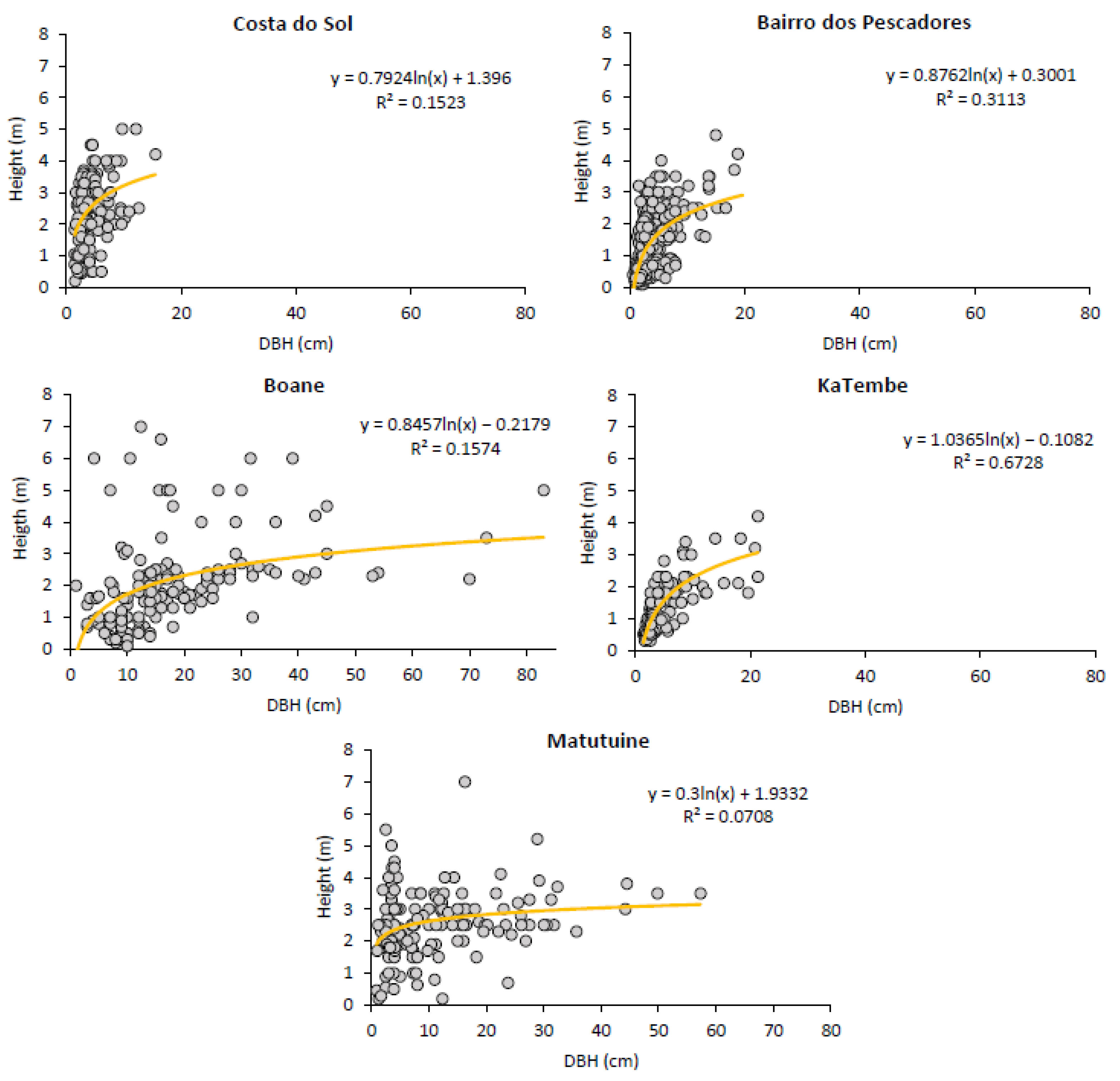
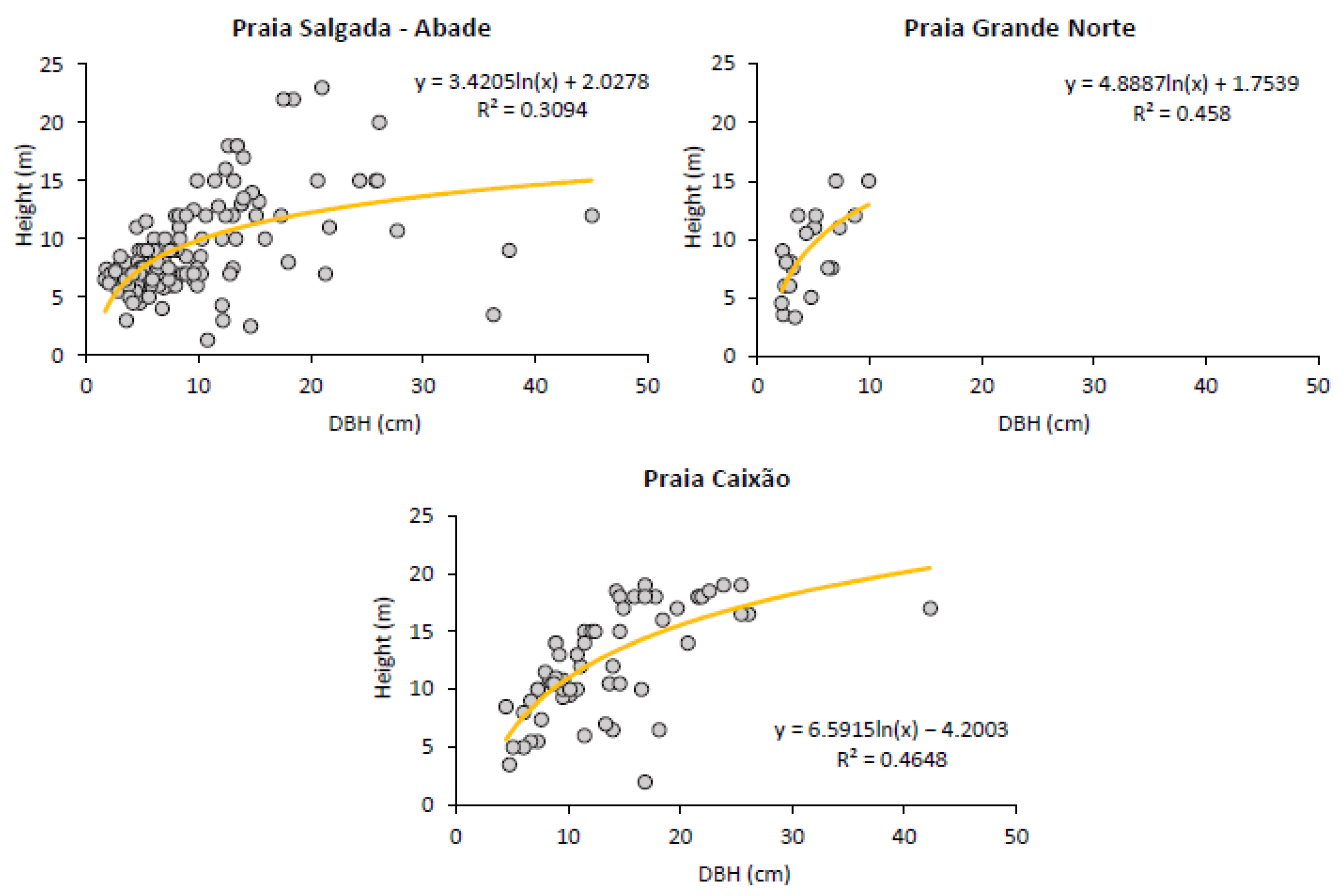
3.2.1. Trees’ DBH and Height Distribution

Table 3 and Table 4 present structural parameters of mangrove forests in both Maputo Bay and on Príncipe Island.
The minimum mean DBH for Maputo Bay was observed at Bairro dos Pescadores and Boane, and the minimum mean height at Katembe (Table 3). According to the mean DBH and height of the trees in the Maputo Bay, the mangrove forest is mainly composed of trees with a mean DBH of 6.98 ± 0.26 cm and a mean height of 1.74 ± 0.034 m. The relationship between DBH and the height of the trees in Maputo Bay (Figure 2) showed that the forests at Costa do Sol, Matutuine and Boane presented taller trees when compared with the other locations.
The mangroves on Príncipe Island have mainly adult trees with the minimum means for DBH and height registered at Praia Grande Norte and the maximum DBH and height means registered at Praia Caixão (Table 4). Praia Salgada and Praia Grande Norte showed similar tree mean heights. Both DBH and Height showed statistically significant difference (Kruskal–Wallis; H = 53.308; DF = 2; N = 262; p < 0.05) and (Kruskal–Wallis; H = 25.879; DF = 2; N = 227; p < 0.05), respectively. On Príncipe Island, the mangrove trees are mainly adults, with mean DBHs of 10.22 ± 0.42 cm and heights of 9.80 ± 0.29 m. The relationship between DBH and the height of the trees on Príncipe Island (Figure 3) showed that Praia Grande presented the lowest DBH (Figure 3).
In terms of structure, the studied mangrove forests in Maputo Bay had younger/smaller trees compared to the ones on Príncipe Island. Statistical differences were found between Maputo Bay and Príncipe Island when comparing the mean DBH (Kruskal–Wallis; H = 136.075; DF = 41; N = 1349; p < 0.05) and the height (Kruskal–Wallis; H = 542.208; DF = 1; N = 1314; p < 0.05).

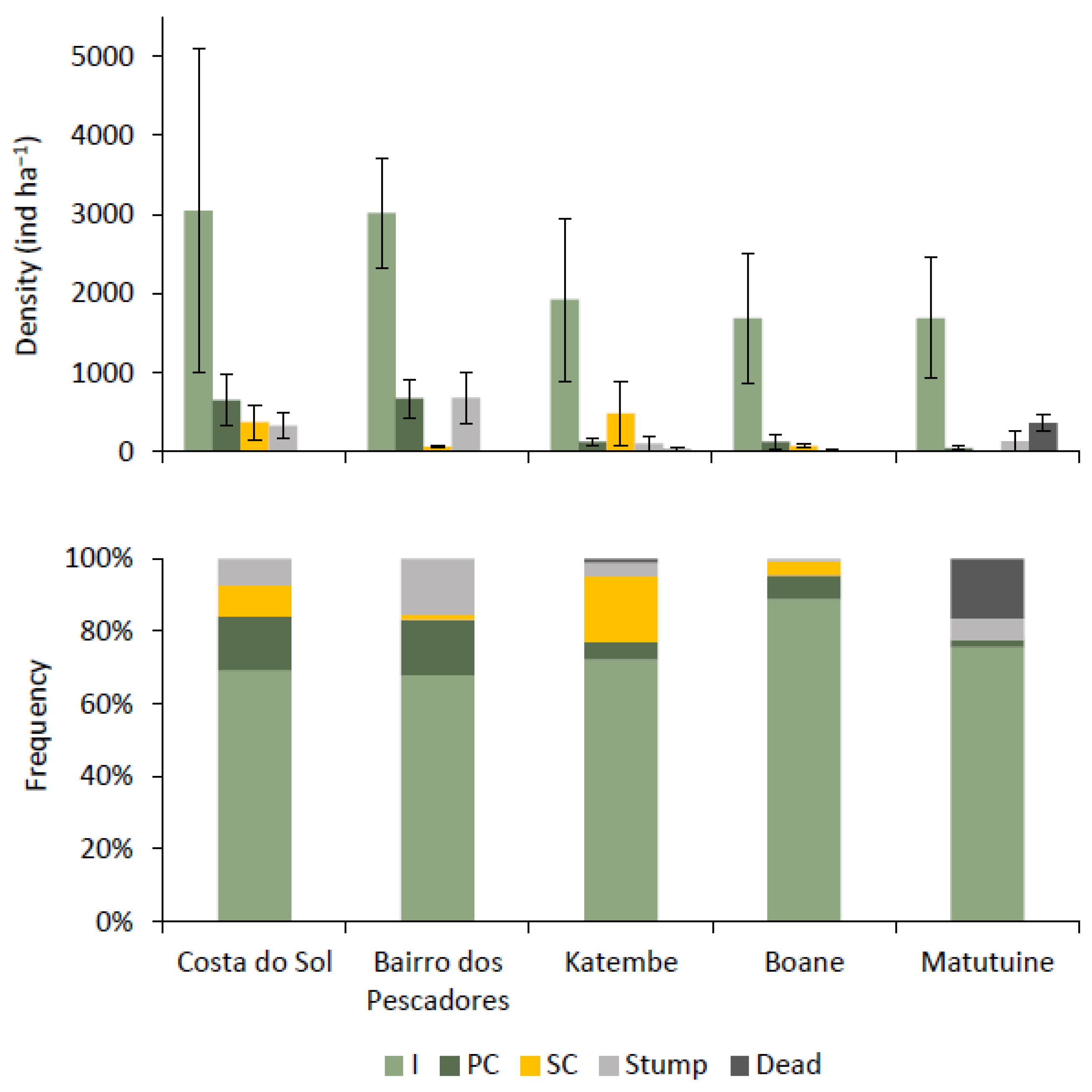
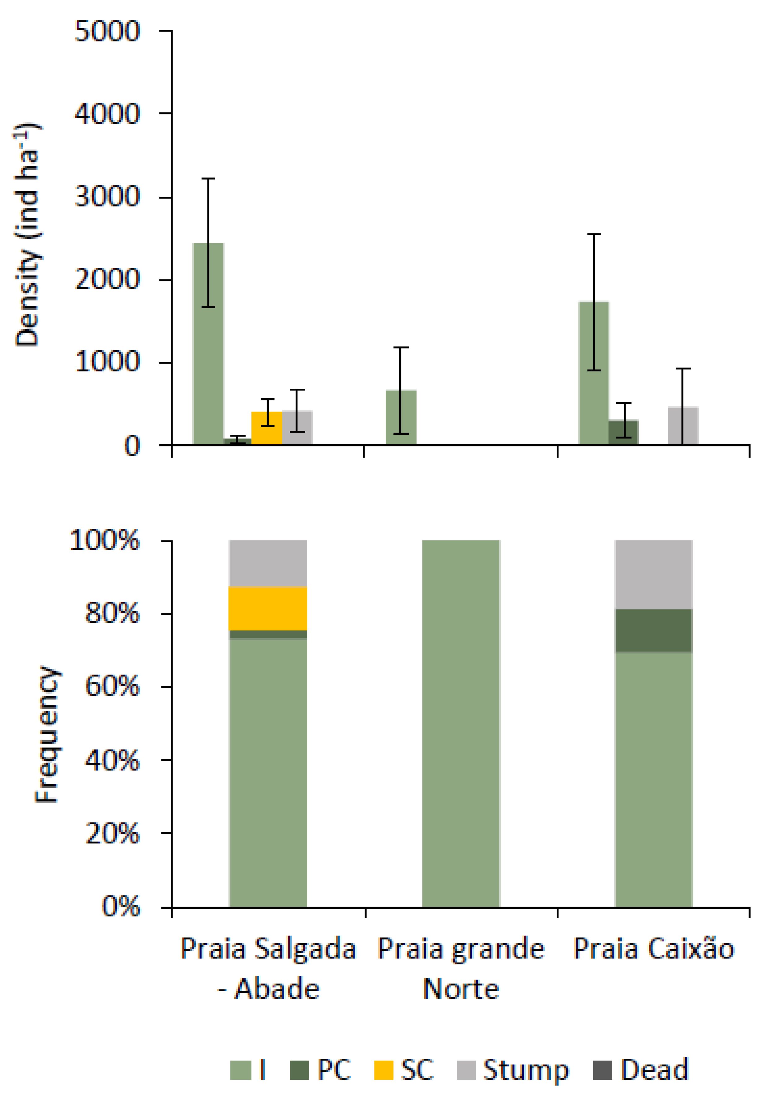
3.2.2. Tree Condition

In general, the study sites in Maputo Bay presented a higher density of intact trees (class I), the majority being A. marina, Costa do Sol presented 3050 ± 2054.47 ind·ha−1, Bairro dos Pescadores with 3016.67 ± 682.67 ind·ha−1, Katembe presented 1928.57 ± 1031.68 ind·ha−1, Boane with 1687.5 ± 814.04 ind·ha−1, and Matutuine with 1688.89 ± 761.29 ind·ha−1, representing 69.32%, 67.92%, 72.19%, 88.82%, and 75.62%, respectively (Figure 4).
On Príncipe Island (Figure 5), Praia Grande was the only site where only intact trees were sampled, with a density of 666.67 ± 517.47 ind·ha−1. At Praia Caixão the highest density of 1 733.33 ± 821.25 ind·ha−1 were intact trees and the lowest were 300 ± 208.17 ind·ha−1, partially cut trees. Stumps were registered in Praia Caixão and Praia Salgada representing, 466.67 ± 466.66 ind·ha−1 and 420 ± 255.73 ind·ha−1, respectively. No dead trees were registered on Príncipe Island, and the proportion of stumps per living trees was 1/7, 0, and 1/4 for Praia Salgada, Praia Grande, and Praia Caixão, respectively.
There were no statistical differences when comparing data from Maputo Bay and Príncipe Island for tree condition (intact trees, partially cut, severely cut, and stumps) (Kruskal–Wallis; p > 0.05).

3.2.3. Stem Quality

Regarding the stem quality in Maputo Bay, it was observed that in the sampled areas most of the trees presented type III poles (curved poles and with no use for construction), representing 92.64% of the sample at Costa do Sol, 88.67% at Bairro dos Pescadores, 96.07% at Katembe, 93.38% at Boane, and 80.81% at Matutuine. This can possibly justify the presence of many intact trees in all the sampled areas. In this class, most trees were A. marina in all the sampled areas, followed by R. mucronata at Katembe and C. tagal at Boane (Figure 6). The next class with a significant number of trees was class II (semi-straight poles), dominated by Avicennia marina at all sites. The remaining were straight poles (class I), although absent in Costa do Sol and Katembe.
Contrastingly, on Príncipe Island most of the trees presented type I poles, representing 83.56% at Praia Salgada, 100% at Praia Grande, and 85.25% at Praia Caixão (Figure 6). Type II poles were present in Praia Caixão (14.75%) and residual in Praia Salgada (2.74%). Type III poles were only registered in Praia Salgada corresponding to 13.70% of the mangrove trees.

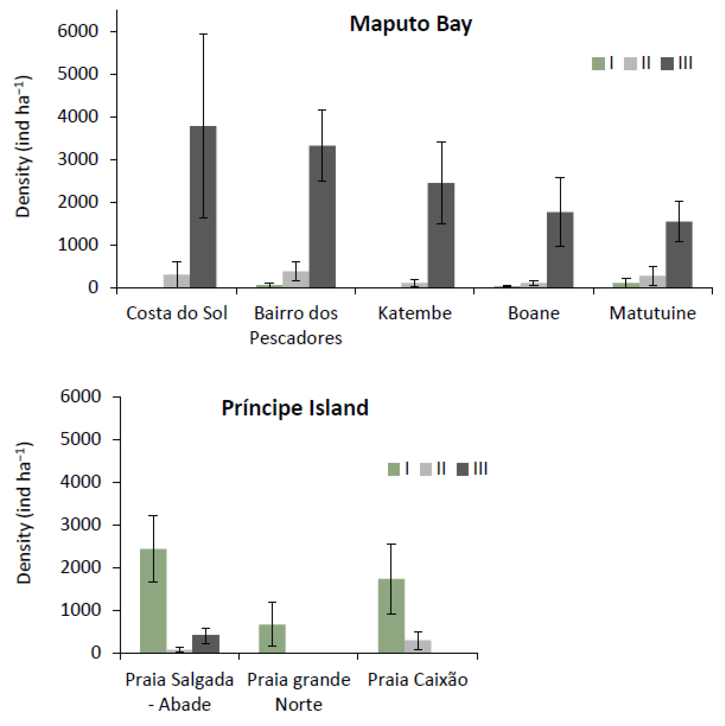
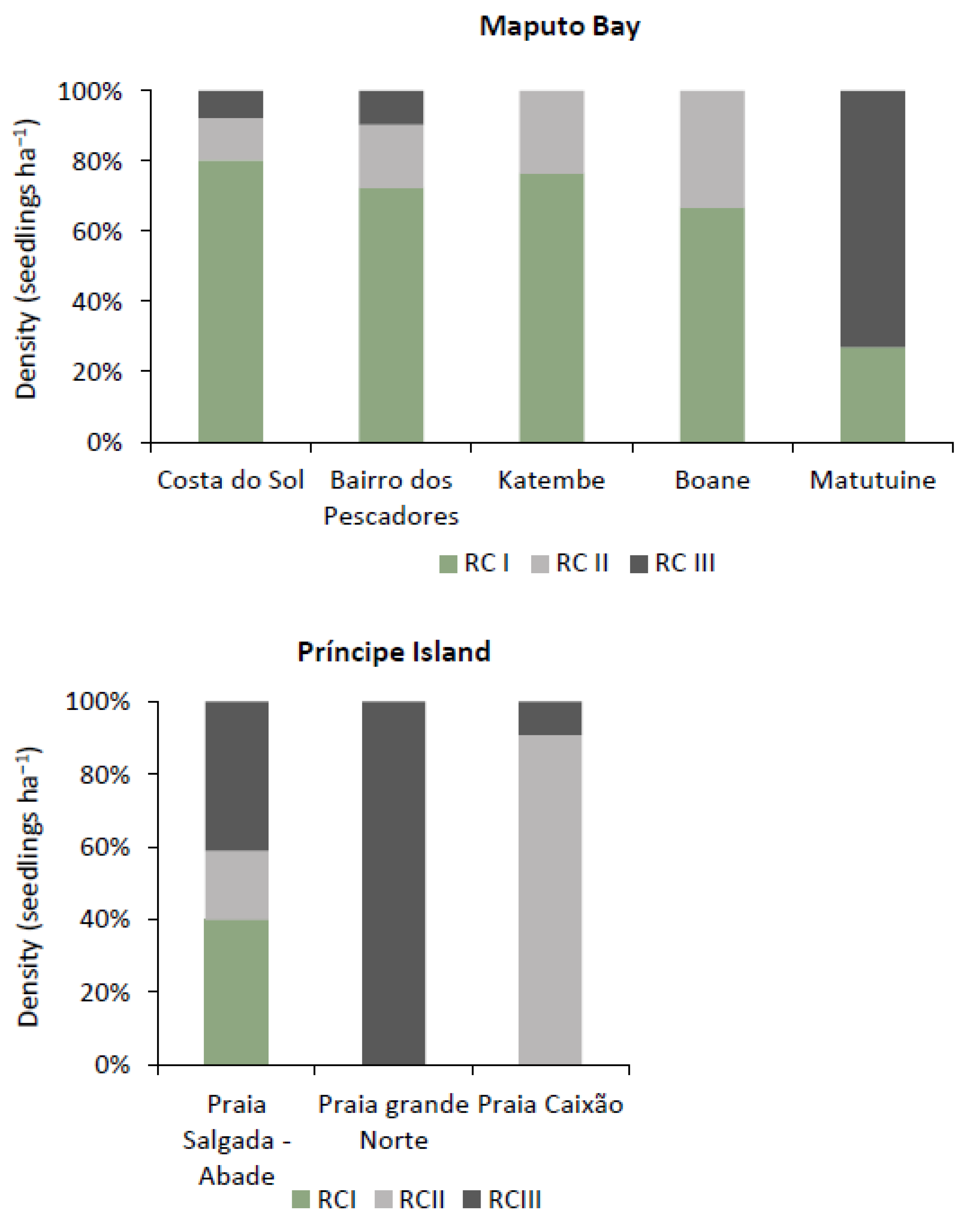
3.2.4. Regeneration Rate

The regeneration potential of the mangroves in the sampled areas was low both in Maputo Bay and on Príncipe Island (Figure 7). In Maputo Bay, the mean density of the seedlings was 144,000 ind·ha−1, where the majority belonged to the first class RCI (0–40 cm height) with 105,800 ind·ha−1, followed by 23,500 ind·ha−1 in the second class RCII (10–150 cm height), and the class RCIII (150 cm and above) with 14,700 ind·ha−1.
On Príncipe Island, the mean density of the seedlings for the RCI was 381.82 ind·ha−1, 272.73 in the RCII and 436.36 for the RCIII. Praia Salgada was the only location with the three regeneration classes. At Praia Grande, only individuals in the RCIII were observed.

3.3. Mangrove Ecosystem Services

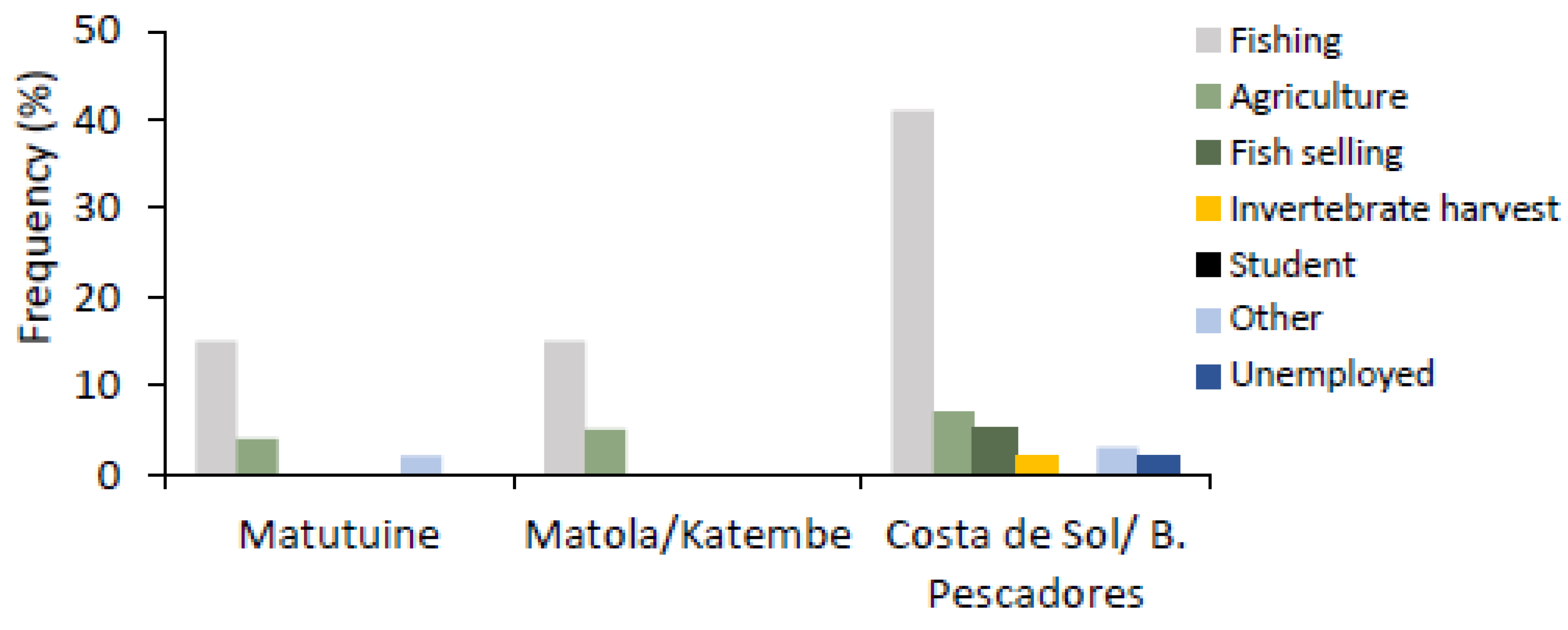
3.3.1. Mangrove Users

In Maputo Bay, it was observed that men and women benefit directly from mangrove resources, exploiting both fishery and forest products. Men and women have different roles in the exploitation of resources (Table 5). On Príncipe Island, the only exploited mangrove resource is from fishermen that extract tannin from the Rhizophora bark for boat painting and gillnet dyeing (Table 5).
According to the Maputo Bay interviewees, men deal with activities that guarantee income generation, such as fishing for shrimp, fish, and sometimes cutting mangrove poles, while women are often focused on subsistence activities, such as collecting firewood for domestic use and collection of invertebrates for consumption (such as collection of clams). Some of these women are sometimes involved in the commercialization of fisheries resources and invertebrates, mainly in the Bairro dos Pescadores and Costa do Sol, to generate additional income for their families, while in Katembe it was observed that the women were involved in collecting invertebrates in the mangrove area mainly for consumption.

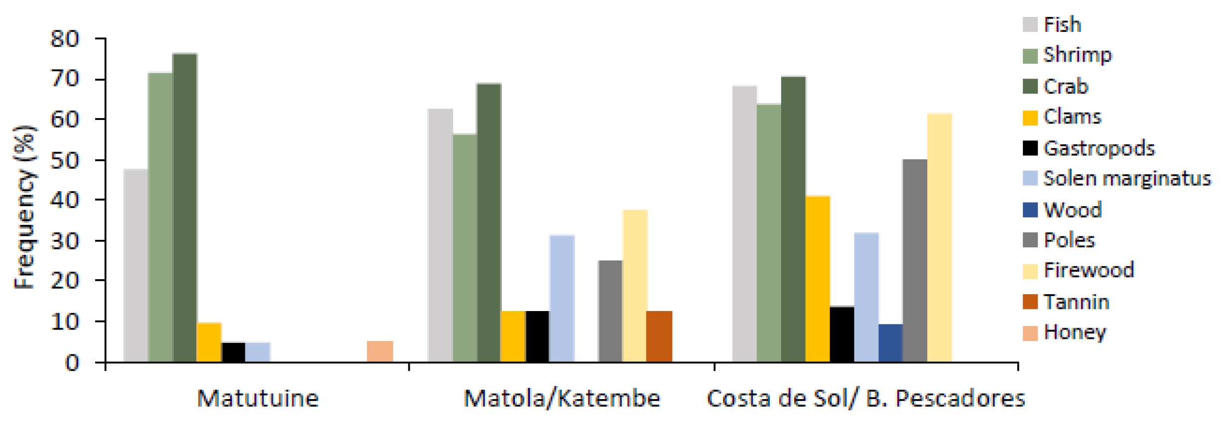
3.3.2. Ecosystem Services and Resource Uses

The main occupation of the interviewed participants in all the sampling sites was fishing, followed by agriculture. However, at the western Maputo Bay (Costa de Sol and Bairro dos Pescadores), more alternative activities were observed (Figure 8).
On Príncipe Island all the people interviewed were fishermen, and they all cited fishing and fishing related activities as their main income generating activity.
The extensive interviews cited different benefits obtained from mangroves and were grouped into extractable and nonextractable goods and services (Table 6). Maputo Bay (eastern Africa) had more services derived from mangroves compared to Príncipe Island (western Africa).
The ES provided by the mangroves in Maputo Bay were largely those of provision. Some interviewees reported that they perceive other services, such as cultural services (tourism and recreation). The products extracted from the mangroves by the communities are divided into two groups: fishery products and wood products. The main fishery products include some fish species, such as Hilsa kelee (magumba), Mugil sp. (taínha), Sillago sihama (pescadinha), mangrove crab (Scylla serrata), blue swimming crab (Portunus pelagicus), shrimp (mostly thin and medium), the bivalves Solen marginatus and clams, and the snail Cerithidea decollata. Wood products include firewood, poles for construction and fencing. Both men and women are engaged in the extraction of mangrove products. Women extract firewood for domestic use while men cut poles for both domestic use and commercialization (mainly).
In Maputo Bay, the mangrove users exploit forest resources as well as fisheries. Among these, the most frequently mentioned resources were crabs, shrimp, and fish, differing in quantities at the different locations (Figure 9).
Based on the interviews, it was observed that fishery resources are commonly more exploited in relation to forest resources (timber and nontimber). Timber forest resources were cited most frequently in the Katembe/Boane areas and from the Costa de Sol to B. Pescadores area. This is the area between Costa de Sol and B. Pescadores, where most interviewees mentioned exploiting wood (9.1%), mainly for the manufacture of boats, firewood (61.4%), and poles for construction (50%). In Katembe/Boane, approximately 23.1% of respondents cited firewood as the main wood resource exploited, followed by poles (15.4%). The extraction of nontimber forest resources was also described, such as bark to produce tannin and honey.
The interviews allowed for the identification of the most exploited mangrove species in Maputo Bay, as well as identifying their main uses within the local communities. Table 7 shows the species of mangrove most commonly used by the local community in Maputo Bay.
Uses varied according to the part of the plant being used, but users also showed preferences for species at each location. The parts of the plant being used range from bark (for extracting tannin), dry branches (for firewood), wood, poles, and lacalacas (small diameter poles). According to the interviewees, in the area between Costa de Sol and Bairro dos Pescadores, the most used species are Avicennia marina and Ceriops tagal, while in Matutuíne and Katembe/Boane A. marina, C. tagal, and Rhizophora mucronata are used by the community (Table 8). Dry branches are used as wood fuel for domestic use, while poles and lacalacas are mostly used for building houses, fencing, poultry houses, and corrals, among others. Bark from the trunks of Rhizophora mucronata is removed for tannin extraction.
Respondents claim that timber and nontimber forest products are important for the livelihood of their families due to the provision of local building materials, firewood for domestic use, among others. Uses vary according to gender in the different communities, where women are more involved in collecting firewood and men more in cutting wood, poles, and ‘lacalacas’.

4. Discussion

4.1. Specific Composition and Abundance of Mangroves

The mangrove forest on Príncipe Island is monospecific, being exclusively dominated by R. harrisonii [24,25]; contrary to Maputo Bay, which has six mangrove species [26,35]; in this study, five species were sampled within Maputo Bay. Globally, eastern and western African coasts have different assemblages of mangrove species, with nine species in eastern Africa and five in western Africa [15,16]. Nevertheless, extensive mangrove stands occur in western Africa with up to 16,260 km2 compared to only 6200 km2 in eastern Africa [13,51]. São Tomé and Príncipe, including Príncipe Island, have few records of their mangroves. Herrero-Barrencua et al. [24] published a report describing the mangrove ecosystems’ faunal lists and flora characterization, and Cravo et al. [52] described the fish assemblages of a mangrove on Príncipe Island. Mangroves are almost encroached on Príncipe Island due to the lack of rivers, the presence of high slopes with restricted low-lying areas for mangrove expansion, and the strong rains with an average annual rainfall ranging from 2000 to 3000 mm, reaching 7000 mm in the cloud forests [38,40], hardly allowing settlement of mangrove seedlings.

4.2. Cut Level and Stem Quality

On Principe Island, it was observed that the forest is dominated by quality I (straight branches) trees, with no signs of cut. Some dead trees were identified due to plant peeling for tannin extraction and naturally dead trees as well [24,25]. The main cause of mangrove death on Principe Island is natural, and the second is related to tannin extraction, which, according to the interviewers, is due to the lack of knowledge of peeling techniques by some of the younger fishermen.
In Maputo Bay, the dominance of quality III (very crooked branches) trees was observed, some of quality II, and few or no trees of quality I, showing high levels of cutting in the forests of Bairro dos Pescadores and Costa do Sol. This association may suggest that trees with qualities I and II (ideal for exploitation) are being depleted by the community, being exploited using full cut (or clear cut), which could justify the high level of stumps in these places.

4.3. Mangrove Structure and Regeneration

The mangrove forest in Maputo Bay is mostly young plants and small trees when compared to Principe Island. This observation is based on the average total height of the trees (1.74 ± 0.034 m) and the average DBH (6.89 ± 0.24 cm). This result is in agreement with data from Macamo et al. [26], who obtained, for the Incomati Estuary (northern Maputo Bay) mangrove forest, an average height of 2.6 m and an average DAP of 7.46. The mangroves on Príncipe Island are mainly adult trees with an average DBH of 10.22 ± 0.42 cm, and an average height of 9.80 ± 0.29 m. Statistical differences were found when comparing the mean DBHs and tree heights between Maputo Bay and Príncipe Island. Eastern and western African mangrove forests may differ, not just in species [53], but in size too, by tending to be relatively smaller in the western Indian Ocean and larger in the eastern Atlantic (e.g., Gabon estuary: [54]). This may be due to the higher global productivity of coastal regions of Southwest Africa when compared to the southeastern African coasts (see [55]).
Fernando and Bandeira [18] also reported that the mangroves in the northern part of Maputo Bay, specifically at Bairro da Costa do Sol, have a very low DBH. The result of this study reveals the same results obtained by Fatoyinbo et al. [9], where the average height of mangrove forests in Maputo is 3.7 m, which corresponds to the lowest average when compared to the provinces of Gaza, Inhambane, Sofala, Zambézia, Nampula, and Cabo Delgado, which range between 4.0–15.9 m. Fernando and Bandeira [45] described the Costa do Sol mangrove as a region where there is high salinity and the average height of the species is 1.5 m, characterized by dwarf trees. The measure of the average height of the trees observed at this location was relatively higher than the height described by Fernando and Bandeira [45].
Regeneration rates were documented in Maputo Bay, where the species that made the greatest contribution to mangrove regeneration were A. marina, C. tagal, and R. mucronata, respectively. Avicennia marina was the species that dominated in all regeneration classes, contrastingly from the study by Macamo et al. [22] that indicated R. mucronata as the dominant species in all the regeneration classes. On Principe Island, a few regenerating individuals were observed. Praia Salgada was the only location where the three regeneration classes individuals were found, in the other hand, at Praia Grande only individuals in the RCIII were observed. This can be explained by the fact that these forests are mainly dominated by a few adult individuals at Praia Grande, and at Praia Salgada and Praia Caixão, all the trees are taller.
In Maputo Bay, it was observed that despite being heavily impacted, the mangrove forests of Costa do Sol and Bairro dos Pescadores have a greater regeneration potential than the potential of the forests of Katembe, Boane, and Matutuíne, with ratios of 10:2:1 and 8:2:1 being less than that considered to be the minimum ecological ratio of 6:3:1 [56] against 3:1:0, 2:1:0, and 0.4:0:1. At Katembe and Boane, mangroves’ existence in class III seedlings was not verified, similar to Macamo et al. [42] findings. This may be indicative that the plants produce seeds and seedlings, but these do not reach the necessary size to be considered small plants.

4.4. Mangrove Conservation

Haroun et al. [37] hypothesized that the small area of mangrove within Principe Island may be a remnant of a larger mangrove area impacted by deforestation. This assumption is yet to be verified as existing new deforestation observed in 2019, especially around Praia Salgada, was within the terrestrial environment rather than a mangrove area. Changes in detection can be used to ascertain whether anthropogenic impact is to blame for the small mangrove areas within the entire STP. A six-month test restoration carried out at PS had mixed results, mainly due to excessive rains that prevented the proper settlement of the seedlings in the nursery. Maputo Bay’s degradation of mangroves is widely reported [26,32] as being impacted by anthropogenic and extreme events. Being lowland, adjacent to mangrove forests, contrary to STP, some swamps and marshlands may invade mangrove areas, temporarily covering mangrove areas, especially during rainy and flood periods.
The results showed that in Maputo Bay, the mangroves are highly impacted and degraded, compared to those on Principe Island. According to Sitoe [53], demographic pressure that leads to increasing unemployment and, therefore, more poverty also contributes to mangrove degradation. In correspondence to São Tomé is the observed degradation of adjacent terrestrial vegetation for agriculture.

4.5. Exploitation of Mangrove Ecosystem Resources

4.5.1. Resources Exploited

Communities in Maputo Bay and Principe Island explore mangrove products differently. In Maputo Bay, the results obtained in the sampled areas indicate that the communities closest to the mangroves extract various fisheries and timber resources, both for consumption and for sale. This shows that the resources provided by the mangroves are of great importance to the socioeconomic condition of these communities, as they manage to generate income for their subsistence [57,58].
On Principe Island, the only mangrove usage indicated by the interviewers was tree peeling for tannin extraction, and this was only for self-use. A similar result was also identified on the neighbouring island of São Tomé [28], where the respondents also mentioned that mangrove areas provide services, such as wild food and atheistic values, mostly. On Príncipe Island, no commercial use of mangrove products was mentioned by the respondents; this can be explained by the extension of the mangrove areas on this island.
On Príncipe Island, no women were identified using mangrove products; the only direct use (tree peeling extraction) was mentioned to be performed by men only. It was also observed that men and women in Maputo Bay showed different preferences and uses of mangrove products, demonstrating that access to mangrove resources in these places is influenced by gender [11]. The gender role is generally different by location, different ethnic groups use the extracted products differently. Women were found to devote much time to activities for which they hardly get any monetary recognition, while men were more involved in the collection of products that were likely to provide some cash income [59,60].
Research conducted elsewhere indicates that women, men, and sometimes children should cooperate and participate for mutual benefit in the exploitation of natural resources [60,61]. In Nigeria, for example, men are given the most difficult jobs, such as fishing, while women mainly deal with the marketing of products [60,62]. The same scenario was found at all the sampling sites. In Maputo Bay, women, such as those engaged in the sale of fish, were found.
Ceriops tagal was cited as preferential in Maputo Bay, followed by Rhizophora mucronata. The preference for this species is mainly related to their availability and the quality of their wood [11]. Ceriops tagal’s wood has great resistance, while the Rhizophora mucronata species presents good wood quality due to its property of retaining thermal energy for a longer period compared to wood from other species [63]. On the other hand, Avicennia marina was cited as the most common species available.

4.5.2. Income-Generating Activities in Maputo Bay

Since the interviewees were mostly residents and explorers of mangrove resources, they chose to devote themselves mostly to these activities, and some already tend to seek alternative activities to fishing and agriculture. In Maputo Bay, the area between Costa de Sol and Bairro dos Pescadores in Maputo City presented a large list of alternative income-generating activities. Maputo Bay is located close to the largest urban center in the country and is the largest area of exploitation of fishery resources in the country, with important fishing centers with many boats, strong pressure on the same resource, and many people involved in the same activity [17,64]. All this creates the need to search for alternative activities, mainly for the low catch seasons, between the months of July and August (dry season).

5. Conclusions

Five mangrove species were identified in Maputo Bay, and the importance value index of the species was higher for A. marina in all the sampling sites, followed by C. tagal. On Príncipe Island, mangroves occupy approximately 1.6 ha, scattered along three major watercourses, and are exclusively dominated by R. harrisonii, most of them are intact trees, with some minor plants with signs of peeling for tannin extraction. The mangroves in Maputo Bay have mostly intact trees and quality III stems, and the highest levels of partial and severe cutting of the trees were found in Costa do Sol and Bairro dos Pescadores.
The socioeconomic profile of the target communities in Maputo Bay showed that more than 90% of the people interviewed are involved in fishing or other activities related to mangroves, both for consumption and for sale. Although both genders were involved in fishing, men were generally involved in fishing and cutting poles for sale and consumption, while women were more involved in collecting invertebrates and firewood for domestic use. The mangrove species cited as the most commonly used in the sampling sites were A. marina, C. tagal, and R. mucronata, with the main uses being for the construction of houses, boats, sealing yards, and for this, stakes and lacquers were used, while firewood was used as a domestic fuel, which is collected by women, preferentially. Although mangroves are recognized as an important source of income for Mozambican communities, they are threatened, mainly by human action, but also by natural and climate change factors, such as cyclones and floods. Threats to mangroves must be addressed by looking at the main drivers of deforestation and degradation. This includes dealing with poverty and alternative sources of livelihood and resources.
The mangroves on Principe Island are rarely used by the communities, except for the tree peelings for tannin production in the one species present on the island, R. harrisonii, and this use is not for commercial purposes. The respondents mentioned that each fisherman extracts the tannin when there is a need to paint their fishing nets. Mangrove management strategies may be weak within Principe Island despite having a larger biosphere reserve (not covering the mangrove forests), and in Mozambique, a new mangrove strategy is yet to exist to impact the several corners of Maputo Bay. Some places have community-based management systems implemented informally. This study recommends that more socioeconomic studies of mangrove resources are needed and should cover more people and different communities in the country.

Author Contributions

Conceptualization, V.M.-A., S.B. and J.P.; methodology, V.M.-A. and C.M.; formal analysis, V.M.-A., A.F. and C.M.; fieldwork, V.M.-A., A.F., M.C., M.M., H.L. and C.M; data curation, V.M.-A., A.F. and M.C.; writing—review and editing, S.B., J.P. and M.C.; supervision, S.B. and J.P.; project administration and funding, J.P. and S.B. All authors have read and agreed to the published version of the manuscript.

Funding

Funds for this study came from AKDN—Aga Khan Development Network—and FCT—Fundação para a Ciência e a Tecnologia IP, Portugal, in the context of COBIO-NET project. Additional support was given by the Ministry of Land and Environment of Mozambique and the Western Indian Ocean Marine Science Association (WIOMSA). This work was also supported by funding from the European Union’s Horizon 2020 Research and Innovation Programme under the grant agreement no. 810139: Project Portugal Twinning for Innovation and Excellence in Marine Science and Earth Observation—PORTWIMS.

Institutional Review Board Statement

Not applicable.

Informed Consent Statement

All interviewees as part of the study received a verbal statement explaining the purpose of the study. The informed consent statement highlighted that the participation in the study was voluntary.

Data Availability Statement

Data from this research is kept under lock and key at the Department of Biological Sciences Research Database. It will be available for reuse by researchers in future studies.

Acknowledgments

We thank the fieldwork assistants and the anonymous reviewers.

Conflicts of Interest

The authors declare no conflict of interest in all parts involved, including the sponsors support and the publication of the results. The study was solely designed, implemented, and written by the authors.

References

  1. FAO. The World’s Mangroves 1980–2005. FAO Forestry Paper; FAO: Rome, Italy, 2007; Volume 153, p. 89. [Google Scholar]
  2. Giri, C.; Ochieng, E.; Tieszen, L.L.; Zhu, Z.; Singh, A.; Loveland, T.; Masek, J.; Duke, N. Status and distribution of mangrove forests of the world using earth observation satellite data. Glob. Ecol. Biogeogr. 2011, 20, 154–159. [Google Scholar] [CrossRef]
  3. Kathiresan, K.; Bingham, B.L. Biology of mangroves and mangrove ecosystems. Adv. Mar. Biol. 2001, 40, 81–251. [Google Scholar]
  4. Kauffman, J.B.; Donato, D.C. Protocols for the Measurement, Monitoring and Reporting of Structure, Biomass and Carbon Stocks in Mangrove Forests. Working Paper 86; CIFOR: Bogor, Indonesia, 2012. [Google Scholar]
  5. Taylor, M.; Ravilious, C.; Green, E.P. Mangroves of East Africa; UNEP, World Conservation Monitoring Centre: Cambridge, UK, 2003; p. 26. [Google Scholar]
  6. Walters, B.B.; Ronnback, P.; Kovacs, J.M.; Crona, B.; Hussain, S.A.; Badola, R.; Primavera, J.H.; Barbier, E.; Dahdouh-Guebas, F. Ethnobiology, socio-economics and management of mangrove forests: A review. Aquat. Bot. 2008, 89, 220–236. [Google Scholar]
  7. McLeod, E.; Salm, R.V. Managing Mangroves for Resilience to Climate Change; IUCN: Gland, Switzerland, 2006; p. 64. [Google Scholar]
  8. Spalding, M.D.; Blasco, F.; Field, C.D. World Mangrove Atlas; The International Ecosystems: Okinawa, Japan, 1997; p. 178. [Google Scholar]
  9. Fatoyinbo, T.E.; Simard, M.; Washington-Allen, R.A.; Shugart, H.H. Landscape-scale extent, height, biomass, and carbon estimation of Mozambique’s mangrove forests with Landsat ETM+ and Shuttle Radar Topography Mission elevation data. J. Geophys. Res. 2008, 113, 13. [Google Scholar] [CrossRef]
  10. Cohen, R.; Kaino, J.; Okello, J.A.; Bosire, J.O.; Kairo, J.G.; Huxham, M.; Mencuccini, M. Propagating uncertainty to estimates of above-ground biomass for Kenyan mangroves: A scaling procedure from tree to landscape level. For. Ecol. Manag. 2013, 310, 968–982. [Google Scholar] [CrossRef]
  11. UNEP. The Importance of Mangroves to People: A Call to Action; van Bochove, J., Sullivan, E., Nakamura, T., Eds.; United Nations Environment Programme World Conservation Monitoring Centre: Cambridge, UK, 2014; p. 128. [Google Scholar]
  12. Alongi, D.M. Present state and future of the world’s mangrove forests. Environ. Conserv. 2002, 29, 331–349. [Google Scholar] [CrossRef]
  13. Bosire, J.O.; Mangora, M.M.; Bandeira, S.; Rajkaran, A.; Ratsimbazafy, R.; Appadoo, C.; Kairo, J.G. (Eds.) Mangroves of the Western Indian Ocean: Status and Management; WIOMSA: Zanzibar Town, Tanzania, 2016; p. 161. [Google Scholar]
  14. Page, S.E.; Rieley, J.O.; Banks, C.J. Global and regional importance of the tropical peatland carbon pool. Glob. Change Biol. 2011, 17, 798–818. [Google Scholar] [CrossRef]
  15. Spalding, M.; Kainuma, M.; Collins, L. World Atlas of Mangroves. A Collaborative Project of ITTO, ISME, FAO, UNEP-WCMC, UNESCOMAB, UNU-INWEH and TNC; Earthscan: London, UK, 2010; p. 319. [Google Scholar]
  16. Beentje, H.; Bandeira, S.O.; Williamson, J.; Moat, J.; Frith, R. Field guide to the mangrove trees of Africa and Madagascar. In Royal Botanic Gardens; Kew Publishing: Richmond, UK, 2007. [Google Scholar]
  17. Bandeira, S.; Paula, J. The Maputo Bay Ecosystem; WIOMSA: Zanzibar Town, Tanzania, 2014; p. 427. [Google Scholar]
  18. Fernando, S.; Bandeira, S. Litter fall and decomposition of mangrove species Avicennia marina and Rhizophora mucronata in Maputo Bay, Mozambique. West. Indian Ocean. 2009, 8, 172–182. [Google Scholar] [CrossRef]
  19. Langa, J.V. Problemas na Zona Costeira de Moçambique com Enfâse para a Costa de Maputo. Rev. De Restao Costeira Integr. 2017, 7, 33–44. [Google Scholar] [CrossRef]
  20. Barbosa, F.M.A.; Cuambe, C.C.; Bandeira, S.O. Status and Distribution of Mangroves in Mozambique. S. Afr. J. Bot. 2001, 67, 393–398. [Google Scholar] [CrossRef]
  21. Diniz, M.A.; Bandeira, S.; Martins, E.S. Flora e Vegetação da Província de Maputo: Sua Apropriação Pelas Populações; Instituto de Investigação Científica Tropical: Lisboa, Portugal, 2013; pp. 1–12. [Google Scholar]
  22. Macamo, C.; Bandeira, S.; Muando, S.; de Abreu, D.; Mabilana, H. Mangroves of Mozambique. In Mangroves of the Western Indian Ocean: Status and Management; Bosire, J.O., Mangora, M.M., Bandeira, S., Rajkaran, A., Ratsimbazafy, R., Appadoo, C., Kairo, J.G., Eds.; WIOMSA: Zanzibar Town, Tanzania, 2016; pp. 51–73. [Google Scholar]
  23. Afonso, F.; Félix, P.M.; Chainho, P.; Heumüller, J.A.; de Lima, R.F.; Ribeiro, F.; Brito, A.C. Assessing Ecosystem Services in Mangroves: Insights from São Tomé Island (Central Africa). Front. Environ. Sci. 2021, 9, 501673. [Google Scholar] [CrossRef]
  24. Herrero-Barrencua, A.; Haroun, R.; Abreu, A.D. Caracterización preliminar de los manglares de la Isla de Príncipe (São Tomé e Príncipe); IU-ECOAQUA, Univ. Las Palmas de Gran Canaria: Telde, Spain, 2017; p. 70. Available online: www.ecoaqua.eu (accessed on 5 July 2020).
  25. Vaz, H.; Oliveira, F. Relatório Nacional do estado geral da biodiversidade de S. Tomé e Príncipe; Ministério de Recursos Naturais e meio Ambiente, Direcção Geral de Ambiente, S. Tomé-RDSTP: São Tomé, República Democrática de S. Tomé e Príncipe, 2007. [Google Scholar]
  26. Macamo, C.; Balidy, H.; Bandeira, S.; Kairo, J.G. Mangrove transformation in the Incomati Estuary, Maputo Bay, Mozambique. WIO J. Mar. Sci. 2015, 14, 10–21. [Google Scholar]
  27. Macamo, C.; Balidy, H.; Bandeira, S. Incomati mangrove deforestation. In The Maputo Bay Ecosystem; Bandeira, S., Paula, J., Eds.; WIOMSA: Zanzibar Town, Tanzania, 2014; pp. 127–130. [Google Scholar]
  28. Afonso, F.; Félix, P.M.; Chainho, P.; Heumüller, J.A.; de Lima, R.F.; Ribeiro, F.; Brito, A.C. Community perceptions about mangrove ecosystem services and threats. Reg. Stud. Mar. Sci. 2021, 49, 102114. [Google Scholar] [CrossRef]
  29. Inácio, A.; Barros, P. Análise do Manancial e da Pescaria de Magumba, Hilsa kelee (Cuvier, 1829) na Baía de Maputo, Moçambique, no Período de 1992–2010. Rev. Moçambicana De Investig. Pesqueira (RIP) 2012, 31, 23–46. [Google Scholar]
  30. Ngale, A. Pesca Artesanal: A sua Contribuição no Rendimento dos Agregados Familiares da Cidade de Maputo–Estudo de caso das Comunidades de Pesca de Gwachene e de Marítimo. Dissertação Apresentada para a Obtenção do grau de Mestre em População e Desenvolvimento; Universidade Eduardo Mondlane: Maputo, Mozambique, 2012. [Google Scholar]
  31. Ferreira, M.A.; Bandeira, S. Maputo bay’s coastal habitats. In The Maputo Bay Ecosystem; Bandeira, S., Paula, J., Eds.; WIOMSA: Zanzibar Town, Tanzania, 2014; pp. 21–24. [Google Scholar]
  32. de Boer, W.F. The Rise and Fall of the Mangrove Forests in Maputo Bay, Mozambique. Wetl. Ecol. Manag. 2002, 10, 313–322. [Google Scholar] [CrossRef]
  33. Dias, J.M.; Canhanga, S. Tidal Characteristics of Maputo Bay, Mozambique. J. Mar. Syst. 2005, 58, 83–97. [Google Scholar]
  34. de Abreu, D.C.; Costa, A.; e Motta, H. (Eds.) . Levantamento Rápido no Arquipélago das Primeiras e Segundas, Contribuição para o Estabelecimento de um Programa de Monitoria; WWF: Maputo, Moçambique, 2008. [Google Scholar]
  35. Paula, J.; Macamo, C.; Bandeira, S. Mangroves of Maputo Bay. In The Maputo Bay Ecosystem; Bandeira, S., Paula, J., Eds.; WIOMSA: Zanzibar Town, Tanzania, 2014; pp. 109–146. [Google Scholar]
  36. Bonfim, F.; Carvalho, S. Fourth National Report on the Biodiversity (1st Draft); CBD Online Reporting Tool São Tomé, República Democrática de São Tomé e Príncipe, 2009. Available online: https://chm.cbd.int/database/record?documentID=201405 (accessed on 5 April 2022).
  37. Haroun, R.; Barrencua, A.H.; Abreu, A.D. Mangrove Habitats in São Tomé and Príncipe (Gulf of Guinea, Africa): Conservation and Management Status. In Threats to Mangrove Forests; Makowski, C., Finkl, C., Eds.; Coastal Research Library, Springer: Cham, Germany, 2018; Volume 25. [Google Scholar] [CrossRef]
  38. Chou, S.C.; de Arruda Lyra, A.; Gomes, J.L.; Rodriguez, D.A.; Alves Martins, M.; Costa Resende, N.; da Silva Tavares, P.; Pereira Dereczynski, C.; Lopes Pilotto, I.; Martins, A.M.; et al. Downscaling projections of climate change in Sao Tome and Principe Islands, Africa. Clim. Dyn. 2020, 54, 4021–4042. [Google Scholar] [CrossRef]
  39. Pisoni, T.; de Lima, R.F.; Brito, A.C.; Chainho, P.; Félix, P.M.; Caçador, I.; Carvalho, A. Planos de Gestão Participativa para dois Sítios de Mangal na Ilha de S. Tomé: Praia das Conchas e Malanza. Abordagem Ecossistémica Integrada para a Conservação e Gestão da Biodiversidade na zona Tados Parques Mpão Naturais obô de São Tomé e Príncipe; ALISEI: São Tomé, São Tomé e Príncipe, 2015; p. 79. [Google Scholar]
  40. NBSAP II. National Biodiversity Strategy and Action Plan 2015–2020, National Commission for Monitoring and Evaluation, Ministry of Infrastructure; Natural Resources and Environment: São Tomé, São Tomé and Príncipe, 2015; p. 120.
  41. Bandeira, S.O.; Macamo, C.C.F.; Kairo, J.G.; Amade, F.; Jiddawi, N.; Paula, J. Evaluation of mangrove structure and condition in two transboundary areas in the Western Indian Ocean. Aquat. Conserv. Mar. Freshw. Ecosyst. 2009, 19, 46–55. [Google Scholar] [CrossRef]
  42. Macamo, C.C.F.; Adams, J.B.; Bandeira, S.O.; Mabilana, H.A.; António, V.M. Spatial Dynamics and Structure of Human Disturbed Mangrove Forests in Contrasting Coastal Communities in Eastern Africa. Wetlands 2018, 38, 509–523. [Google Scholar] [CrossRef]
  43. Nicolau, D.K.; Macamo, C.C.; Bandeira, S.O.; Tajú, A.; Mabilana, H. Mangrove change detection, structure, and condition in a protected area of eastern Africa: The case of Quirimbas National Park, Mozambique. WIO J. Mar. Sci. 2017, 16, 47–60. [Google Scholar]
  44. Servino, R.N.; Gomes, L.E.D.O.; Bernardino, A.F. Bernardino. Extreme weather impacts on tropical mangrove forests in the Eastern Brazil Marine Ecoregion. Sci. Total Environ. 2018, 628–629, 233–240. [Google Scholar] [CrossRef] [PubMed]
  45. Finch, H.; Lewis, J. Focus groups. In Qualitative Research Practice; Ritchie, J., Lewis, J., Eds.; Sage Publications: London, UK, 2003. [Google Scholar]
  46. Greenbaum, T.L. The Handbook of Focus Group Research, 2nd ed.; Sage Publications: London, UK, 1998. [Google Scholar]
  47. Rosales, R.M.; Pomeroyb, R.; Calabioc, I.J.; Batongd, M.; Cedoe, K.; Escaraf, N.; Facunlag, V.; Gulayanh, A.; Narvadezi, M.; Sarahadilj, M.; et al. Value chain analysis and small-scale fisheries management. Mar. Policy 2017, 83, 11–21. [Google Scholar] [CrossRef]
  48. Tuan, V.Q. Valuation of Mangrove Ecosystems along the Coast of the Mekong Delta in Vietnam: An Approach Combining Socio-Economic and Remote Sensing Methods. Doctoral Thesis, University of Kiel, Kiel, Germany, 2013. [Google Scholar]
  49. Brander, L.; Baggethun, E.G.; López, B.M.; Verma, M. The economics of valuing ecosystem services and biodiversity. In The Ecological and Economic Foundations; Kiel University: Kiel, Germany, 2010. [Google Scholar]
  50. Zafar, M.; Ahsan, N. Marketing and Value Chain Analysis of Mud Crab (Scylla sp.) in the Coastal Communities of Bangladesh; Institute of Marine Sciences, Chittagong University: Chittagong, Bangladesh, 2006. [Google Scholar]
  51. Fatoyinbo, T.E.; Simard, M. Height and biomass of mangroves in Africa from ICESat/GLAS and SRTM. Int. J. Remote Sens. 2013, 34, 668–681. [Google Scholar] [CrossRef]
  52. Cravo, M.; Almeida, A.J.; Lima, H.; e Silva, J.A.; Bandeira, S.; Machava-António, V.; Paula, J. Fish Assemblages in a Small Mangrove System on Príncipe Island, Gulf of Guinea. Front. Mar. Sci. 2021, 8, 721692. [Google Scholar] [CrossRef]
  53. Sitoe, C. Análise da Sustentabilidade do mangal no Âmbito da Construção de Infra-estruturas na Zona Costeira: Caso Costa do Sol. Master’s Thesis, University Eduardo Mondlane, Maputo, Mozambique, 2018; p. 35. [Google Scholar]
  54. Trettin, C.C.; Dai, Z.; Tang, W.; Lagomasino, D.; Thomas, N.; Lee, S.K.; Simard, M.; Ebanega, M.O.; Stoval, A.; Fatoyinbo, T.E. Mangrove carbon stocks in Pongara National Park, Gabon, Estuarine. Coast. Shelf Sci. 2021, 259, 107432, ISSN 0272-7714. [Google Scholar] [CrossRef]
  55. Shapiro, A.; Trettin, C.; Küchly, H.; Alavinapanah, S.; Bandeira, S. The Mangroves of the Zambezi Delta: Increase in Extent Observed via Satellite from 1994 to 2013. Remote Sens. 2015, 7, 16504–16518. [Google Scholar] [CrossRef]
  56. FAO. Mangrove Forest Management Guidelines. (FAO Forestry Paper 117); Food & Agriculture Org.: Rome, Italy, 1994. [Google Scholar]
  57. Aye, W.N.; Wen, Y.; Marin, K.; Thapa, S.; Tun, A.W. Contribution of Mangrove Forest to the Livelihood of Local Communities in Ayeyarwaddy Region, Myanmar. Forests 2019, 10, 414. [Google Scholar] [CrossRef]
  58. Kusmana, C.; Sukristijiono, S. Mangrove Resources Uses by Local Community in Indonesia. J. Pengelolaan Sumberd. Alam Dan Lingkung. 2016, 6, 217–224. [Google Scholar] [CrossRef]
  59. Bandeira, S.; Macamo, C.; Mabilana, H.; Muhanzule, R. Lesson learnet of mangrove restoration–implemented in several provinces by MICOA/MITADER (Danida). Intern. Report 2016. [Google Scholar]
  60. Olaleye, S.M.; Omokhua, G.E. Women involvement, empowerment and control of non-timber mangrove forest products in Rivers State. Niger. J. Agric. Food Environ. 2012, 8, 9–13. [Google Scholar]
  61. Acharya, G. Life at the Margins: The Social, Economic and Ecological Importance of Mangroves. Instituto de Ecologia, A.C. Xalapa, México. 2015. Available online: http://www.redalyc.org/articulo.oa?id=61709803 (accessed on 4 April 2022).
  62. Teka, O.; Houessou, G.; Lougbegnon, O.T.; Oumorou, M.; Sinsin, B. Mangrove Degradation and Endogenous Strategies for Participatory Restoration and Conservation in Benin. 2012. Rufford final report.
  63. Numbere, A.O. Perception of Mangrove Forest Protection and Utilization amongst Residents in Some Coastal Communities in the Niger Delta, Nigeria. Curr. Trends For. Res. 2019, 3, 1039. [Google Scholar]
  64. Mojiol, A.R.; Guntabid, J.; Lintangah, W.; Ismenyah, M.; Kodoh, J.; Chiang, L.K.; Sompud, S. Contribution of mangrove forest and socio-economic development of local communities in Kudat district, Sabah Malaysia. J. Trop. Resour. Sustain. Sci. 2016, 4, 38–41. [Google Scholar]
Figure 1. Location of sampling areas in Maputo Bay (eastern Africa) and Príncipe Island (western Africa).
Forests 13 01466 g001
Figure 2. Relationship of the trees’ height (m) and DBH (cm) in Maputo Bay study sites.
Forests 13 01466 g002
Figure 3. Relationship of the trees’ height (m) and DBH (cm) on Príncipe Island study sites.
Forests 13 01466 g003
Figure 4. Density (±SE) and percentage of intact (I), partially cut (PC), severely cut (SC), stumps and dead trees, in Maputo Bay.
Forests 13 01466 g004
Figure 5. Density (±SE) and frequency of intact (I), partially cut (PC), severely cut (SC), stumps and dead trees, on Príncipe Island.
Forests 13 01466 g005
Figure 6. Density (±SE) according to stem quality classes in Maputo Bay and Príncipe Island. Class I, II and III, representing, straight poles, semi-straight, and curved poles, respectively.
Forests 13 01466 g006
Figure 7. Regeneration rate in Maputo Bay and Príncipe Island. RCI–regeneration class I, RCII–Regeneration class II and RCIII–Regeneration class III.
Forests 13 01466 g007
Figure 8. Interviewers’ occupation by location in the surroundings of mangrove forests of Maputo Bay.
Forests 13 01466 g008
Figure 9. Exploited resources in mangrove forests of Maputo Bay according to the interviews.
Forests 13 01466 g009
Table 1. Characterization of Maputo Bay and Príncipe Island mangrove sampled areas.
LocationSoil CompositionInundation ClassesSoil TypeForest Type
Maputo BayCosta do SolClayAll spring tides
High spring tide
Extreme spring tide
Firm
Intermediate
Basin
Dwarf mangroves
Bairro dos PescadoresClay
Sand/clay
Peat/clay
All the neap tides
All spring tides
High spring tide
Firm
Intermediate
Basin
Fringe
KatembeSand
Clay
Sand/clay
Peat
Peat/clay
All the neap tides
All spring tides
High spring tide
Extreme spring tide
Firm
Intermediate
Basin
Dwarf mangroves
Estuarine
BoaneSand/clay
Peat/clay
All the neap tides
All spring tides
High spring tide
Firm
Intermediate
Basin
Riverine
MatutuineSand/clayAll spring tides
High spring tide
Firm
Intermediate
Basin
Dwarf mangroves
Príncipe IslandPraia Salgada/AbadeSand/clayAll the neap tidesFirm
Intermediate
Basin
Riverine
Praia GrandeSand/clay
Peat/clay
All the neap tidesFirm
Intermediate
Basin
Riverine
Praia CaixãoSand
Clay
Sand/clay
All the neap tidesFirm
Intermediate
Basin
Riverine
Table 2. Importance Index Values (IIV), showing the importance of each species within the forests sampled in specific area.
LocationSpeciesRelative Values
DensityDominanceFrequencyIIV
Maputo BayCosta do SolA. marina
C. tagal
98.86
1.14
98.89
1.11
80.0
20.0
277.75
22.25
Bairro dos PescadoresA. marina
B. gymnorhiza
C. tagal
R. mucronata
94.17
0.38
2.81
2.63
96.00
0.33
2.70
0.97
63.16
5.26
21.05
10.53
253.33
5.96
26.58
14.13
BoaneA.marina
R. mucronata
X. granatum
82.24
17.11
0.66
63.82
35.84
0.34
77.78
11.11
11.11
223.84
64.06
12.11
KatembeA. marina
B. gymnorhiza
C. tagal
R. mucronata
86.17
0.53
9.63
3.74
80.24
5.78
9.13
4.85
0.86
7.69
30.77
15.38
204.17
14.00
49.53
23.98
MatutuineA. marina
B. gymnorhiza
C. tagal
R. mucronata
47.09
12.87
32.75
7.02
73.31
4.84
16.57
5.27
53.85
15.38
15.38
15.38
174.25
33.02
65.10
27.63
Príncipe IslandPraia Salgada-AbadeR. harrisonii100100100300
Praia Grande NorteR. harrisonii100100100300
Praia CaixãoR. harrisonii100100100300
Table 3. Mangrove structural parameters at the different locations in Maputo Bay.
ParametersMaputo Bay
Costa do SolBairro dos PescadoresBoaneKatembeMatutuíne
SamplingN = 176Q = 4N = 532Q = 12N = 152Q = 8N = 187Q = 7N = 171Q = 9
Mean DBH (cm) ± SE4.37 ± 0.193.94 ± 0.1318.09 ± 1.074.58 ± 0.2810.44 ± 0.78
Mean Height (m) ± SE2.42 ± 0.081.31 ± 0.052.00 ± 0.121.24 ± 0.0642.50 ± 0.09
N° of species24344
Mean Density (ind·ha−1) ± SE4400.00 ± 2595.54433.33 ± 841.571900.00 ± 791.92671.43 ± 945.091911.11 ± 650.5
Basal area (m2·ha−1)0.341.095.980.623.00
Complexity index0.070.250.680.080.57
Table 4. Mangrove structural parameters at the different locations on Príncipe Island.
ParametersPrincipe Island
Praia Salgada-AbadePraia Grande NortePraia Caixão
SamplingN = 168Q = 5N = 20Q = 3N = 75Q = 3
Mean DBH (cm) ± SE9.5 ± 0.534.65 ± 0.5213.31 ± 0.73
Mean Height (m) ± SE8.93 ± 0.328.72 ± 0.7812.24 ± 0.58
N° of species111
Mean Density (ind·ha−1) ± SE3340 ± 603.82667 ± 517.472500 ± 1357.7
Basal area (m2·ha−1)12.830.175.11
Complexity index3.830.011.56
Table 5. Use of mangrove resources by gender in Maputo Bay and Príncipe Island.
LocationOccupation
MenWomen
Maputo BayFishingInvertebrate collection
Timber extractionFish selling
Firewood extraction
Príncipe IslandTannin production-
Fishing-
Table 6. Main ecosystem goods and services derived from mangroves forests in Maputo Bay and Príncipe Island.
Goods/ServicesUsesLocation
Maputo BayPríncipe Island
Non–extractableCoastal protection
Tide flooding control
Water purification
Aesthetical beauty
Nursery ground
Fishing ground
ExtractableFirewood
Charcoal production
Timber
Shrimp fishing
Invertebrates’ collection
Tannin production
Table 7. Distribution of respondents for other exploited resources in Maputo Bay.
Uses Site%
Tannin extraction Costa do Sol/B. Pescadores
Katembe/Boane
4.5%
7.7%
Honey extraction Matutuine4.8%
Fishery resourcesCrabsCosta do Sol/B. Pescadores
Katembe/Boane
Matutuíne
70.5%
42.3%
76.2%
ShrimpCosta do Sol/B. Pescadores
Katembe/Boane
Matutuine
64.6%
34.6%
71.4%
FishCosta do Sol/B. Pescadores
Katembe/Boane
Matutuine
68.2%
38.5%
47.6%
Table 8. Main mangrove species used by the community in Maputo Bay.
Scientific Name
(Common Name)
AreaMain Uses
Avicennia marina
(White mangrove)
Costa do sol, Katembe/Boane and Matutuine
-
Firewood: used as a wood fuel for domestic use and as a raw material to produce charcoal.
-
Wood: used for building houses.
-
Poles: used for building houses and making boats.
Ceriops tagal
(Indian mangrove)
Costa do sol, Katembe/Boane and Matutuine
-
Poles and lacalacas: used for the construction of houses (mainly kitchens and bathrooms). Rod-shaped poles are used for roofing houses.
-
Firewood: wood fuel for domestic use.
Rhizophora mucronata
(Red mangrove)
Katembe/Boane and Matutuine
-
Poles: used for the construction and manufacture of boats.
-
Tree peeling: used for tannin extraction.
Publisher’s Note: MDPI stays neutral with regard to jurisdictional claims in published maps and institutional affiliations.

