Abstract
The fractal characteristics of soil particle-size distribution (PSD) constitute an important soil physical property, and fractal models of soil PSD are increasingly used to describe the effects of vegetation on the improvement of soil-related properties. Based on the fractal theory, this paper selected four typical vegetation restoration types (Quercus acutissima, QAC; Robinia pseudoacacia, RPL; Pinus densiflora, PDS; QAC × PDS) in the Taiyi mountainous area as the research object, and the single-fractal dimension (D) and multi-fractal parameters of PSD and its correlation with soil-associated properties were studied. The results show that (1) QAC × PDS reduced the heterogeneity of soil sand distribution, which also increased the range and concentration of soil PSD in the dense area. Soil clay and silt contents showed QAC × PDS > RPL > QAC > PDS. QAC × PDS significantly increased clay and silt content in 0–20 cm soil. (2) D varies among different vegetation restoration types, which was QAC × PDS > RPL > QAC > PDS, and the D of 0–20 cm soil was greater than that of 20–40 cm. For the multi-fractal parameters of PSD, the capacity dimension (D0), information dimension (D1), correlation dimension (D2) and D1/D0 in 0–20 cm soil of different vegetation restoration types showed significant differences. (3) D and multi-fractal parameters were significantly positively correlated with clay and silt contents, which were significantly negatively correlated with sand contents. (4) QAC × PDS had the smallest soil bulk density and largest porosity. Fractal dimension was negatively correlated with soil bulk density and positively correlated with soil total porosity and capillary porosity. These results indicate that the soil fractal dimension can well characterize the vegetation improvement on soil structure and properties in the earthy-rocky mountain areas of northern China.
1. Introduction
The earthy-rocky mountain areas in northern China have poor soil and an arid climate. Human over-exploitation and vegetation destruction have made the ecological environment in this area fragile and susceptible to serious soil erosion. Vegetation restoration is the key to ecological restoration in this area [1,2]. The Taiyi Mountain Area is typical in the earthy-rocky mountain area of northern China. As more and more attention is paid to the protection and restoration of the ecological environment, the region has implemented several vegetation restoration projects, such as the National Soil and Water Conservation Key Project and the Grain for Green Program. The vegetation restoration types have a significant effect on soil properties and soil quality [3,4,5,6]. The optimal configuration of plant patterns is a key step for plant measures to restore the ecosystem in the earthy-rocky mountain areas. Soil particle composition and its multifractal characteristics are quantitative indicators reflecting the improvement of soil texture and soil fertility by vegetation. Soil is an irregular, complex, and porous medium composed of different particles, with self-similarity structures and fractal characteristics [7], which can be quantitatively studied by fractal theory [8,9,10].
The fractal characteristics of soil particles in different vegetation restoration types are closely related to the soil structure and composition and soil formation process. Moreover, they have a significant impact on soil erosion characteristics and fertility status, which is one of the most important soil physical properties [11,12]. Recently, most fractal models of soil structure are based on the single fractal characteristics of soil structure. Li et al. [13] and Xu et al. [14] used the single fractal theory to discuss the relationship between the bulk density, the content of each particle grade, and the single fractal dimension (D) of soil particles in different vegetation types. The study found that there was a correlation between the D value and the soil physicochemical properties, and it had a decreasing trend with increasing soil depth. However, the single fractal can only describe and characterize the overall and average level of soil microstructure, but it cannot characterize the local fractal characteristics. Therefore, it is limited to using a single fractal method to study soil. In recent years, many scholars have begun to use the multifractal method to describe the characteristics of soil structure, that is, to use the multifractal spectrum to describe the local variability and heterogeneity of soil structure [15,16]. The multifractal method can use multiple fractal parameters to describe complex soil geometry, characterize soil properties, and capture more extensive and detailed information about soil particle-size distribution (PSD). Thus, multifractal technology is an excellent choice for studying soil particle distribution [16]. The laser particle size analysis technology can accurately analyze the particle composition of the soil to provide sufficient data for multifractal calculation [15]. As a result, the combination of the multifractal method and laser particle size analysis technology provides an accurate analytical method for the study of soil PSD in different vegetation types.
Soil physicochemical properties can comprehensively evaluate soil quality [17], showing a close relationship between soil physicochemical properties and fractal dimension. Using fractal dimension instead of soil particle composition is of great significance to studying the relationship between soil particle composition and soil physicochemical properties of different vegetation types [18,19]. Physical properties such as soil bulk density and porosity can not only characterize the weight of soil particles per unit volume and the size of pores but also directly reflect the air permeability and water permeability of the soil. Fractal dimension is an important indicator to express the physical properties of soil particles, such as soil particle shape and texture, and reflects its ability of it to fill space. It has been found that the fractal dimension of different vegetation types was positively correlated with soil bulk density and negatively correlated with porosity. This indicates that the higher the fractal dimension, the denser the soil structure [13,20,21]. The soil fractal dimension has a significant negative correlation with the gravel content and a significant positive correlation with silt and clay content [22]. To further verify that the soil fractal characteristics can be used as an ideal indicator to characterize soil stability and soil fertility, Niu et al. [23] have studied the correlation between soil fractal parameters and soil chemical properties of different vegetation types, especially with soil organic matter. Some studies have found that the fractal dimension was significantly positively correlated with soil organic matter, total nitrogen, available nitrogen, total potassium, available potassium, total phosphorus, and available phosphorus. Within a certain range, the higher the fractal dimension, the richer the clay content in the soil and the more active the chemical properties of the soil are [19,22]. However, due to the differences in land use patterns and vegetation coverage, the correlation between soil fractal characteristics and soil physicochemical properties was not obvious [24]. Chen et al. [25] found that the content of soil organic matter decreased with the fractal dimension increase in soil particles, and the fractal parameters of soil particles may have a strong spatial specificity in indicating soil nutrients. Because of regional differences, vegetation differences, and the influence of many human factors, the research results of the correlation between soil fractal parameters and soil physicochemical properties are not the same. However, it can be considered that the fractal dimension of soil particle composition of different vegetation types has great research value and potential, and it can be used as a comprehensive index to quantitatively describe the physicochemical properties, such as soil texture, soil density, soil pore structure and soil fertility.
The Taiyi Mountain Area in Shandong Province was selected as the study area, which is a typical area in the earthy-rocky mountain area of northern China and a national control area for soil erosion. The typical ecological restoration afforestation tree species in this area are Quercus acutissima, Robinia pseudoacacia, Pinus densiflora, etc. The forest vegetation existence will participate in the soil formation, affect soil structure, improve soil physicochemical properties and soil fertility, etc., and the fractal dimension can better reflect the soil properties changes. However, the current research on typical vegetation for ecological restoration in this region mainly focuses on the ecological characteristics of the “leaf–litter–soil” continuum, and the change characteristics in soil microbial communities during litter decomposition [6,26,27], so there is still a lack of research on the fractal characteristics of soil particles of vegetation restoration types. Therefore, to a certain extent, it affects the quantitative evaluation of soil improvement function of vegetation restoration types in the ecological restoration in this area. In this paper, four vegetation restoration types, Quercus acutissima forest (QAC), Robinia pseudoacacia forest (RPL), Pinus densiflora forest (PDS), and mixed forest of Quercus acutissima–Pinus densiflora (QAC × PDS) were selected as the research objectives in Taiyi Mountain Area of Shandong province. Using the method of combining field fixed-point sampling and indoor quantitative analysis, the research was carried out with fractal theory. The primary goals of this research involved the analyses of (1) Characteristics of soil PDS, single fractal and multifractal parameters of four vegetation restoration types. (2) Influence characteristics of different vegetation restoration types on soil particle and fractal dimension. (3) Factors affecting soil fractal dimension under four vegetation restoration types. This study can provide a theoretical basis for the rational allocation of forest vegetation structure and quantitative evaluation of soil improvement function in earthy-rocky mountain areas and similar areas in China.
2. Materials and Methods
2.1. Description of Site
The study area is located in Mount Tai Forest Ecosystem National Positioning Observation and Research Station (E117°04′–117°22′, N36°16′–36°28′) in the Huangqian watershed of Tai’an City, Shandong Province. It is located in the northwest of the Taiyi Mountain Area of Shandong province in the earthy-rocky mountain area of northern China, with a total area of 292.20 km2 (Figure 1). The soil type is Haplic Luvisol formed by granite gneiss (World Reference Base for Soil Resources, WRB). The soil layer is relatively thin, with an average thickness of 30–40 cm, mostly slightly acidic, and the pH value is 5.5–6.5. It is a warm temperate continental semi–humid monsoon climate. Moreover, the average annual rainfall is 758 mm, and 75% of the precipitation is concentrated between June and September. The study area is a national key ecological protection forest area with a forest coverage rate of 89%. The vegetation type is the warm temperate deciduous broad-leaved forest, mainly including Quercus acutissima Carruth., Robinia pseudoacacia L., Pinus densiflora Sieb. Et Zucc., and Larix kaempferi (Lamb.) Carr.
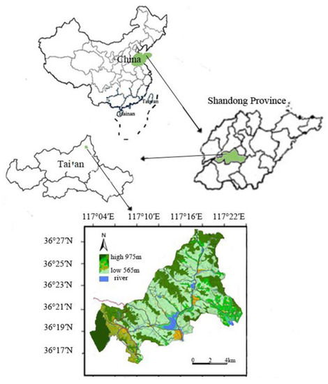
Figure 1.
Map of the location of the study area.
2.2. Study Subjects and Soil Sampling
In May 2019, Robinia pseudoacacia monospecies forest (24 years), Quercus acutissima monospecies forest (25 years), Pinus densiflora monospecies forest (27 years), and the mixed forest of Quercus acutissima-Pinus densiflora (27 years) with relatively consistent habitat conditions were selected for the study in the Huangqian watershed of Tai’an City, Shandong Province (Table 1 and Table A2). Five 10 m × 10 m sample plots were set up in each of the four sample plots (RPL, QAC, PDS, and QAC × PDS). The sampling depth of the soil samples was determined according to the depth of the main distribution layer of vegetation roots and rock layers in the area. Soil samples from 0 to 20 cm and 20 to 40 cm soil layers were collected in each sample plot using a cutting ring (diameter is 10 cm, height is 10 cm) for the determination of soil bulk density and porosity (Table A1). Five sampling points were identified in an “S” pattern in each sample square. The soil samples from the five sampling points in each sample square were mixed thoroughly to form one test sample. Soil samples were collected in plastic bags from 0 to 20 cm and 20 to 40 cm soil layers. Soil samples are taken to the laboratory and air-dried in a dark, dry place in preparation for later use. A total of 40 soil samples were collected from the four sample plots.

Table 1.
The basic status of the study area.
2.3. Sample Processing and Analysis
The plant roots and litter were removed from the air-dried samples before they were passed through a 2.0 mm sieve. The soil (0.5 g) was placed in a 50 mL test tube, which was then placed in a 72 °C water bath, and 10 to 15 mL of 10% H2O2 was added to the tube to remove the organic matter. Then, add 10 mL of 10% HCl and continue heating in the water bath for 4–5 h to remove calcium carbonate. To disperse soil particles, add (NaPO3)6 dispersant and vibrate with an ultrasonic wave. The volume fraction of soil particles was measured using a laser granularity analyzer (Mastersizer 2000, UK) [28]. The laser granularity analyzer was used for measurements in the range 0.02–2000μm with a stirring speed of 2500 r/min and a shading range of 10%–20%. The classification of soil PSD is based on the United States Department of Agriculture (USDA) classification criteria: clay (<0.002 mm), silt (0.002–0.05 mm), and sand (0.05–2 mm). The total volume percentage of soil particles in the corresponding particle size range from the laser granule size instrument is the sum of the clay, silt, and sand content of the soil.
Soil physicochemical properties were determined by conventional methods [29]: soil bulk density and porosity were determined by the cutting ring method; soil pH was determined by the potentiometric method with a soil-to-water ratio of 1:2.5 and extracted with distilled water; soil organic carbon (C) content was determined by the K2Cr2O7 oxidation-external heating method; total nitrogen (N) content was determined by the H2SO4-H2O2 digestion method; and total phosphorus (P) was determined by the Mo-Sb antispectrophotography method with a detection wavelength of 880 nm.
2.4. Soil Fractal Dimension
2.4.1. Single Fractal Dimension
A volumetric fractal model of soil particles was used to calculate the single fractal dimension [30], which was calculated as follows:
In the equation, R is the arithmetic mean of the upper and lower limits of a particle size interval, V(r < R) is the cumulative volume of particles with a particle size less than R (where volume is the percentage volume), VT is the total volume of soil particles, is the cumulative percentage volume of soil particles with a particle size less than R, λv is the upper limit of all components, which is numerically equal to the maximum particle size (mm), and D is the soil fractal dimension.
2.4.2. Multiple Fractal Dimensions
The laser particle size analyzer range is I = [0.02, 2000], which is divided into 100 small intervals Ii = [φi, φi+1], (i = 1, 2, ..., 100), where lg(φi+1/φi) is a constant, so that the intervals follow the soil size distribution and are more objective [31]. To analyze the soil PSD of interval I using the multiple fractal method, the subintervals must be of equal length, make φi = lg (φi, φi), a new dimensionless interval J = [lg (0.02/0.02), lg (2000/0.02)] = [0, 5] is constructed, and 100 new equidistant intervals Ji = [φi, φi+1], i = 1, 2, ..., are generated. The volume fractions corresponding to the 100 intervals of particle size are denoted by v, i.e., v1, v2, ..., v100. A multiple fractal analysis of soil PSD is performed by dividing the entire span of the soil PSD by N equal ‘boxes’ of scale ε. In the interval J, ε = 5 × 2−k, N = 2k. In this paper, k takes the values [1, 6] and ε takes the values 2.5, 1.25, 0.625, 0.3125, 0.15625, and 0.078125.
Multifractal analysis with a PSD interval of I is typically performed using a continuous partition of binary-scaled intervals. If the diameter I is L, the binary separation of k stages (k = 1, 2, 3, …) produces a plurality of elements, N(ε) = 2 k, the diameter of which, ε = L × 2−k, covers each size scale, ε, where we consider N(ε) = 2 k pixels. Their respective metrics, μi(ε), are provided using available data. Data should be normalized as per in order to provide a measure of probability. Regarding the PSD, the diffraction particle size analyzer calculates the μi(ε) of the size of each subinterval and indicates the relative volume of soil particles with a characteristic size in the subinterval [32,33].
The multifractal generalized dimensional spectrum of soil PSD is [34]
Using Equation (2), the generalized dimensional spectrum D(q) can be obtained, with D0 being the capacity dimension when q = 0 and D2 being the correlation dimension when q = 2. Using Equation (3), D1 is the information dimension when q = 1 [16].
Using Formulas (2) and (3), the multifractal dimensions of soil particles in the range of −10 ≤ q ≤ 10 are calculated, and the generalized dimensional (Rényi) spectrum D(q) − q is drawn in steps of 1. D(q) is the singularity index of the soil PSD, and q is the real number. The Rényi spectrum is a classical tool to characterize complex distributions that are closely related to the multifractal singularity spectrum but have an easier handling and interpretation [32].
2.5. Data Processing and Statistical Analysis
Microsoft Excel 2016 was used for data collation. All statistical analyses were performed using SPSS 19.0 and the origin 2018 was used for plotting. One-way analysis of variance and the least significant difference method were used to compare differences between data. Pearson correlation analysis and stepwise regression analysis were used to evaluate the relationship between soil particle composition, soil fractal dimension and soil physicochemical properties. The data shown in the figures and tables are expressed as mean ± standard error.
3. Results
3.1. Soil PSD Characteristics of Four Vegetation Restoration Types
3.1.1. Frequency Characteristics of Soil Particle
The distribution of the soil particle content of the four vegetation restoration types in the different particle size ranges is non-uniform (Figure 2). The curve of QAC × PDS has little variation, the distribution of soil volume content is relatively homogeneous in each particle size section, the content of fine particles (<50 μm) is high, and the RPL is the second highest. The curves of QAC and PDS were highly variable, and the particles were mainly concentrated in the particle size range of 50–1000 μm, with coarse particles dominating and marked heterogeneity. The results showed that QAC × PDS could reduce the heterogeneity of soil sand distribution and increase the extent of PSD and the concentration in dense soil areas.

Figure 2.
Frequency curves of soil particles for four vegetation restoration types. QAC × PDS is the mixed forest of Quercus acutissima–Pinus densiflora, RPL is the Robinia pseudoacacia forest, QAC is the Quercus acutissima forest, PDS is the Pinus densiflora forest. (a) represents the frequency curves of soil particles of 0–20 cm soil layer, (b) represents the frequency curves of soil particles of 20–40 cm soil layer.
3.1.2. Distribution Characteristics of Soil Particles
As can be seen from Figure 3, there were significant differences (p < 0.05) in the soil particle content distribution between the different vegetation restoration types. Soil clay and silt content followed a consistent pattern, i.e., QAC × PDS > RPL > QAC > PDS. Sand content dominated the four vegetation-restoration-type soils, ranging from 44.50% to 61.97%. The clay content ranged from 3.00% to 4.87% and the silt content ranged from 35.03% to 50.76%. The QAC × PDS had the highest content of silt, which was 1.16 times higher than the silt content of PDS.
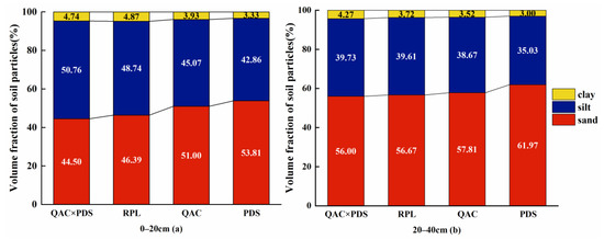
Figure 3.
Soil particle composition of four vegetation restoration types. QAC × PDS is the mixed forest of Quercus acutissima–Pinus densiflora, RPL is the Robinia pseudoacacia forest, QAC is the Quercus acutissima forest, PDS is the Pinus densiflora forest. (a) represents the frequency curves of soil particles of 0–20 cm soil layer, (b) represents the frequency curves of soil particles of 20–40 cm soil layer.
3.2. Single Fractal Characteristics of Soil Particles of Four Vegetation Restoration Types
The present study found significant differences in D values of four vegetation restoration types (p < 0.05). The order of D values was QAC × PDS > RPL > QAC > PDS (Figure 4). It showed that QAC × PDS has the smallest soil particle size and the finest grain texture among the four vegetation types, and it was easy to form a soil structure with a good water and fertilizer retention effect. RPL and QAC were next, and PDS was the worst. From the perspective of the vertical section, the D value of the 0–20 cm soil layer is greater than that of the 20–40 cm soil layer. It showed that in the 20–40 cm soil layer, the soil particles are coarse, the texture is poor, the soil structure is loose, and it is easy to lose water and fertilizer, which is not conducive to vegetation growth. Due to the accumulation of litter under the forest and the soil and fertilizer conservation effect of vegetation roots, the soil layer of 0–20 cm can increase the soil aggregate structure and form more fine-grained materials, resulting in a large D value. However, after the natural process of evolution, the soil structure of the 20–40 cm soil layer was gradually compacted, the coarse-grained materials in the soil increased, and the D value decreased.
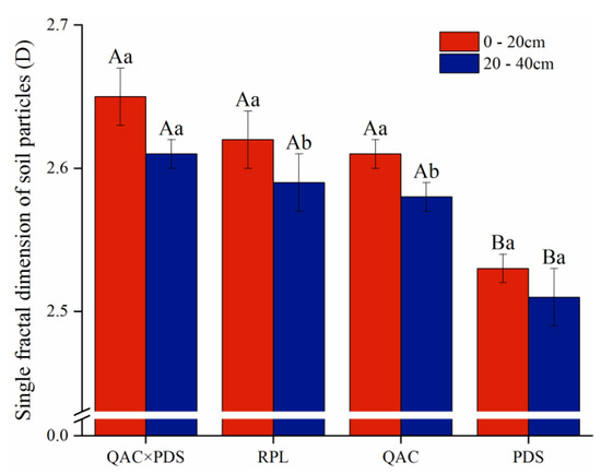
Figure 4.
Single-fractal dimension of soil particles under four vegetation restoration types. Different letters indicate significant differences at the level of p < 0.05. Capital letters indicate the comparison of the same soil depth of different vegetation types. Lowercase letters indicate the comparison of different soil depths of the same vegetation type.
3.3. Multifractal Characteristics of Soil Particles of Four Vegetation Restoration Types
3.3.1. Rényi Spectrum of Soil Particle Distribution in Four Vegetation Restoration Types
The Rényi spectrum is a typical inverse S-shaped decreasing curve of different soil layers of four vegetation restoration types (Figure 5). The range of the D0 value is 0.8643–0.9386, the range of the D1 value is 0.8637–0.9228, and the range of the D2 value is 0.8413–0.9201. On the whole, it showed the trend of D0 > D1 > D2. In summary, it indicates that the soil particle size of four vegetation restoration types is unevenly distributed, and it is highly necessary to carry out multifractal analysis [28,35].
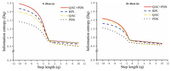
Figure 5.
Multi-fractal Rényi spectra D(q) − q curves of four vegetation restoration types. (a) represents the frequency curves of soil particles of 0–20 cm soil layer, (b) represents the frequency curves of soil particles of 20–40 cm soil layer.
3.3.2. Multifractal Dimension of Soil Particles of Four Vegetation Restoration Types
On the 0–20 cm soil layer, there are significant differences between the four vegetation restoration types in terms of soil capacity dimension (D0), information dimension (D1), correlation dimension (D2), and information dimension/capacity dimension (D1/D0) values (Table 2). D0 is a parameter used to describe the distribution range of soil particles. The D0 value of QAC × PDS is the highest (0.9386, 0.9274), followed by RPL and QAC, and PDS was the lowest (0.9049, 0.8643). It shows that QAC × PDS has the widest distribution range of soil particles and the narrowest PDS. D1 value can be used to characterize the uniformity of soil particle distribution. The greater the D1 value, the greater the degree of unevenness. The order of the D1 value is QAC × PDS > RPL > QAC > PDS (Table 2). It illustrates that QAC × PDS has the largest uneven distribution of soil particles and the highest irregularity. D2 value can describe the aggregation degree of the soil particle distribution. The larger the D2 value, the smaller the degree of aggregation and the more dispersed the soil particles. The D2 value of QAC × PDS is the largest and QAC is the smallest. The D1/D0 value is a parameter reflecting the heterogeneity of soil particle distribution. The greater the D1/D0 value, the greater the degree of heterogeneity, that is, the volume percentage of soil particles in each classification tends to be consistent. When D1/D0 is equal to 1, it indicates that the distribution of soil particles is mainly concentrated in dense areas. When D1/D0 value is equal to 0, it indicates that the particle distribution is mainly concentrated in the sparse area. The D1/D0 value of QAC × PDS was the largest (0.9893), and QAC is the smallest (0.9525), indicating that the soil particles of QAC × PDS are mainly distributed in dense areas. In summary, except D1/D0 value, other multifractal parameters (D0, D1, and D2) basically follow the rule of QAC × PDS > RPL > QAC > PDS. QAC × PDS has the widest distribution range of soil particles, and the largest degree of non-uniformity and heterogeneity.
Table 2.
Multifractal dimension of soil particle of four vegetation restoration types.
3.4. Relationship between Fractal Dimension of Soil Particles and Soil PSD of Four Vegetation Restoration Types
D value has a highly significant positive correlation with the content of clay and silt (R2 = 0.8546, p = 0.001; R2 = 0.7336, p = 0.007), which has a highly significant negative correlation with the content of sand (R2 = 0.7443, p = 0.006) (Figure 6), that is, the higher the content of clay and silt and the lower the content of sand in soil, the greater the D value is. The correlation coefficient between clay content and D value is the largest and the p value the smallest, indicating the most significant correlation between D value and clay content.
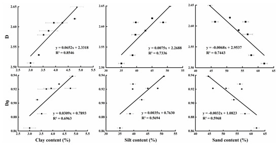
Figure 6.
Relations between fractal parameter of D, D0 and volume percentage of different soil particle sizes under four vegetation restoration types. D is the single fractal dimension, D0 is the capacity dimension.
D0 value is highly significantly positively correlated (R2 = 0.6963, p = 0.010) with clay content, significantly positively correlated (R2 = 0.5694, p = 0.030) with silt content, and significantly negatively correlated (R2 = 0.5968, p = 0.025) with sand content (Figure 6), that is, the higher the content of clay and silt and the lower the sand content in soil, the greater the D0 value. The correlation coefficient between clay content and D0 value is the largest and the p value the smallest, indicating the most significant correlation between D0 value and clay content. The relationship between D1 and D2 values and the content of each particle size is generally consistent with D0 values.
4. Discussion
4.1. Infuluence of Four Vegetation Restoration Types on Soil PSD and Associated Physicochemical Properties
The study area is located in the earthy-rocky mountain area of northern China. The infertile soil, arid climate and excessive human exploitation have caused serious damage to the vegetation in the area. Under the action of erosion such as wind erosion and water erosion, the fine-grained soil is lost and the soil is gradually coarsened. Soil particle composition is related to vegetation types, in addition to soil parent material and environmental changes [19,36]. In this study, sand content (44.50%–61.97%) dominates the soils of the four types of vegetation restoration in the earthy-rocky mountain area of northern China, which is consistent with the findings of Liu et al. [37]. Studies have shown that vegetation restoration can effectively promote soil particle refinement [38,39]. This study found that the silt and clay contents of QAC × PDS were higher than those of other stands, and it was superior to other communities in improving soil texture. This is because where there is no vegetation cover, the surface layer is eroded, and the loss of fine particles and nutrients causes the soil texture to become coarse with a predominant coarse sand content [40]. After vegetation restoration, root growth and plant litter affect the physical, chemical and biological soil properties and accelerate the formation of humus, which is conducive to the formation and fixation of fine particles. In addition, the frequency curves of soil PSD of the four vegetation restoration types can reflect the soil texture, and the smaller the curve changes, the greater the degree of particle heterogeneity [39]. The curve of QAC × PDS shows the least variation and more uniform texture (Figure 2). It indicates that the soil of the mixed forest is well developed and can better consolidate the soil and improve the soil structure.
Soil texture determines several soil properties, including porosity and nutrient content [41]. Therefore, we try to discuss the correlation between fractal dimension and soil physicochemical properties, and further verify that the soil fractal dimension is a good indicator for systematically characterizing soil physicochemical properties and soil quality. This study found that soil bulk density was negatively correlated with fractal dimension. It was extremely significantly negatively correlated with D1 (R2 = −0.991, p < 0.01), and significantly negatively correlated with D0 (R2 = −0.984, p < 0.05). There was a positive correlation between soil total porosity and fractal dimension. It was significantly positively correlated with D0 and D1 (R2 = 0.982 and R2 = 0.988, p < 0.05). There is a positive correlation between soil capillary porosity and fractal dimension. It was significantly positively correlated with D0 and D1 (R2 = 0.977 and R2 = 0.984, p < 0.05) (Table 3). Liu et al. [24] studied the correlation between the fractal characteristics of soil particles and soil characteristics of four vegetation restoration types, and concluded that the fractal parameters were negatively correlated with bulk density but positively correlated with saturated water content and capillary porosity. This is basically consistent with the research results of this paper. However, some scholars have studied the relationship between the soil fractal dimension and physicochemical properties in the Loess Plateau. They found that the fractal dimension was negatively correlated with porosity and positively correlated with bulk density [42]. This may be related to the different environmental factors such as climate and soil in the study area, or it may be caused by different vegetation restoration types in the study area.
Table 3.
Correlation analysis between soil fractal dimension and associated physicochemical properties of four vegetation restoration types.
There was a positive correlation between soil C, N and P content and fractal dimension. However, none of the correlations between the nutrient content of the soil and the fractal dimension were significant. Studies have shown that the fractal dimension is positively correlated with soil nutrient indexes [23]. Zhang et al. [43] have found that the fractal dimension is positively correlated with the content of N and P in soil. Li et al.’s research [44] shows that the fractal dimension is positively correlated with the content of C, N and K, and significantly negatively correlated with P content. These research results are basically consistent with the conclusions of this paper. However, some studies have also shown that soil fractal dimension is negatively correlated with nutrient indicators. For example, Ma et al. [45], He and Wang [42] and others have found that the fractal dimension is negatively correlated with the content of soil C, N, P, etc. Different scholars have different research results on the correlation between fractal dimension and soil nutrient index. This may be the spatial selective distribution of nutrient content or the increase in nutrient content, which has little effect on the fractal characteristics [24]. Comprehensive analysis shows that the correlation between the fractal dimension of soil particles and soil physical properties is higher than that with soil chemical properties. It shows that the fractal dimension of soil can more directly reflect the physical properties of soil and indirectly reflect some chemical properties. This indicates that the fractal parameters of soil PSD could act as quantitative indices to reflect the soil physical properties and could be used to describe the influences of different vegetation restoration types on soil structure.
4.2. Effects of Four Vegetation Restoration Types on Fractal Parameters of Soil Particles
Vegetation can lead to changes in the fractal characteristics of soil particles by influencing soil texture [39]. Differences in vegetation type can indirectly influence soil particle fractal parameters [37]. This study concluded that the D value of soil particles was negatively correlated with the thickness of the soil layer, the order of four vegetation restoration types was QAC × PDS > RPL > QAC > PDS, and the mixed forest was greater than the monospecies forest. Wu et al. [46] studied the relationship between the soil D value and the content of each particle size of a developing benggang in southeast China and found that the D value was positively correlated with the content of clay and silt and negatively correlated with sand content, which was consistent with the results of this paper. It shows that the larger the D value, the finer the soil particles and the better the soil quality. However, due to different factors such as vegetation types and afforestation structures in the study area, some scholars have obtained inconsistent results with this study. Ma et al. [45] indicated that the D value increased with the increase in soil depth by calculating the soil D value of different types of Betula platyphylla forests in the mountainous northwest Hebei Province of China. The D value of the monospecies forest is greater than that of the broad-leaved mixed forest and the coniferous and broad-leaved mixed forest.
To further study the distribution of soil particles, some scholars studied the multifractal parameters of soil particles of different vegetation restoration types from the perspective of multifractal. The D(q) − q function is an inverse S-type decline curve, and the multifractal dimension decreases with the increase in soil depth. This is well confirmed in this study as well. The fractal dimension decreases with the increase in soil depth, which may be related to the high content of litter in surface soil and the spatial distribution of organic matter [42]. This study shows that the multifractal dimension of the mixed forest is greater than that of the monospecies forest, and that of the broad-leaved forest is greater than that of the coniferous forest. It shows that the soil texture of the mixed forest and broad-leaved forest is uniform and the particles are fine, so it has good water retention performance. This may be related to the volume of litter in forest land and the spatial distribution of soil nutrients [47].
4.3. Soil Fractal Dimension Prospects and Research Limitations
In this paper, the soil PSD and fractal characteristics of QAC, RPL, PDS, and QAC × PDS were studied by using fractal theory, and the influencing factors of the soil fractal dimension under the four vegetation restoration types were clarified. QAC × PDS has greater advantages in soil PSD and fractal parameters than other tree species (QAC, RPL and PDS). Therefore, during the ecological restoration process in the earthy-rocky mountain area of northern China, QAC × PDS can be preferentially used as afforestation tree species. Our results show that the coniferous and broad-leaved mixed forests and the broad-leaved forests are better than coniferous when evaluating the soil improvement effect of vegetation restoration types in northern China from the perspective of the soil fractal dimension. Meanwhile, the soil fractal dimension can well demonstrate the improvement effect of different vegetation restoration types on the soil structure and properties in northern China. Our research focused on a typical area and over a certain time, adding new information and data to a very complex subject and region that had no consistent conclusions and indeed lacked research.
However, this study also has some limitations. First, it being a small-scale and short-term study means that it cannot fully characterize the characteristic changes of soil particles. Second, the influence of vegetation on soil PSD and fractal is indirect, and our research ignored the changes between vegetation and soil. Next, we will expand the scope of research to study the effects of different soil-forming parent materials on soil PSD and fractal. At the same time, different vegetation types most directly affect the thickness, species and decomposition of litter. Therefore, in future research, “organic matter” can be used as a key index to further study the coupling effect of litter-soil organic matter and soil PSD during the maturation of soil parent material in depth.
5. Conclusions
Our study suggests that the four vegetation restoration types have significant differences in soil particle composition and fractal dimension in the ecological restoration areas of northern China. The order of clay and silt content is Quercus acutissima–Pinus densiflora > Robinia pseudoacacia forest > Quercus acutissima forest > Pinus densiflora forest. Due to the uneven distribution of soil particle size, the overall performance of soil multifractal parameters was capacity dimension > information dimension > correlation dimension, and Quercus acutissima–Pinus densiflora > Robinia pseudoacacia forest > Quercus acutissima forest > Pinus densiflora forest. The values of the single-fractal dimension, capacity dimension, information dimension and correlation dimension have a highly significant positive correlation with clay and silt contents, and a highly significant negative correlation with sand content. Thus, as the soil texture changes from fine to coarse, the soil fractal dimension decreases, and the soil fractal dimension can be used to evaluate the soil improvement effect of vegetation restoration types in the ecological restoration area.
In addition, the fractal dimension of soil particles can well reflect the physical properties of soil and can be used to describe the effects of different vegetation restoration types on soil structure. Quercus acutissima–Pinus densiflora has the smallest soil bulk density and the largest porosity, followed by Robinia pseudoacacia forest, Quercus acutissima forest and Pinus densiflora forest. Soil carbon and nitrogen contents showed Robinia pseudoacacia forest > Quercus acutissima–Pinus densiflora > Quercus acutissima forest > Pinus densiflora forest. The soil bulk density of four vegetation restoration types was significantly negatively correlated with the fractal dimension. Soil total porosity and capillary porosity were significantly positively correlated with fractal dimension.
Our results show that the coniferous and broad-leaved mixed forests and the broad-leaved forests are better than coniferous when evaluating the soil improvement effect of vegetation restoration types in northern China from the perspective of the soil fractal dimension. Meanwhile, the soil fractal dimension can well demonstrate the improvement effect of different vegetation restoration types on the soil structure and properties in northern China. However, this study also has some limitations. The small-scale and short-term cannot fully characterize the characteristic changes of soil particles.
Author Contributions
Conceptualization, W.S., Y.G. and P.G.; Data curation, W.S.; Formal analysis, W.S.; Investigation, W.S. and Y.G.; Methodology, W.S. and Y.G.; Software, G.W.; Supervision, G.W.; Validation, X.D. (Xingjian Dun) and J.X.; Visualization, W.S., P.G. and X.D. (Xingjian Dun); Writing—original draft, W.S.; Writing—review and editing, X.D. (Xuede Dong). All authors have read and agreed to the published version of the manuscript.
Funding
This research was funded by Shandong Agricultural Science and Technology Fund (Forestry Science and Technology Innovation) of China, grant number 2019LY006, the Mount Tai Forest Ecosystem National Orientation Observation and Research Station Monitoring Subsidy Project, grant number 2018-LYPT-DW-053.
Institutional Review Board Statement
Not applicable.
Informed Consent Statement
Not applicable.
Data Availability Statement
Not applicable.
Conflicts of Interest
The authors declare no conflict of interest.
Appendix A
Table A1.
Soil physicochemical properties of four vegetation restoration types.
Table A1.
Soil physicochemical properties of four vegetation restoration types.
| Indicators | Soil Depth (cm) | QAC × PDS | RPL | QAC | PDS |
|---|---|---|---|---|---|
| Bulk density (g/cm3) | 0–20 | 1.06 ± 0.01 Ab | 1.10 ± 0.02 Ab | 1.31 ± 0.02 Ba | 1.40 ± 0.03 Aa |
| 20–40 | 1.10 ± 0.01 Ba | 1.25 ± 0.05 Ba | 1.38 ± 0.02 Aa | 1.43 ± 0.03 Aa | |
| Total porosity (%) | 0–20 | 55.02 ± 0.80 Aa | 52.32 ± 0.34 Ba | 48.84 ± 0.24 Ca | 46.55 ± 0.36 Ca |
| 20–40 | 50.22 ± 0.20 Ab | 46.57 ± 0.10 Bb | 44.71 ± 0.11 Cb | 43.11 ± 0.17 Db | |
| Capillary porosity (%) | 0–20 | 49.01 ± 0.31 Aa | 46.32 ± 0.14 Ba | 43.62 ± 0.15 Ca | 41.93 ± 0.65 Ca |
| 20–40 | 45.08 ± 0.18 Ab | 41.75 ± 0.11 Bb | 40.36 ± 0.17 Cb | 38.55 ± 0.32 Db | |
| C(g/kg) | 0–20 | 21.37 ± 0.14 Ba | 23.22 ± 0.68 Aa | 18.33 ± 0.20 Ca | 17.43 ± 0.13 Ca |
| 20–40 | 15.75 ± 0.21 Ab | 14.67 ± 0.14 Bb | 13.01 ± 0.06 Cb | 12.24 ± 0.16 Db | |
| N(g/kg) | 0–20 | 1.00 ± 0.01 Ba | 1.14 ± 0.02 Aa | 0.43 ± 0.01 Ca | 0.24 ± 0.01 Da |
| 20–40 | 0.79 ± 0.04 Ab | 0.71 ± 0.01 Bb | 0.28 ± 0.01 Cb | 0.18 ± 0.01 Db | |
| P(g/kg) | 0–20 | 0.19 ± 0.01 Ba | 0.25 ± 0.01 Aa | 0.19 ± 0.01 Ba | 0.18 ± 0.01 BCa |
| 20–40 | 0.17 ± 0.01 Bb | 0.20 ± 0.01 Ab | 0.19 ± 0.01 ABa | 0.17 ± 0.01 Ba |
QAC × PDS stands for mixed forest of Quercus acutissima-Pinus densiflora, RPL stands for Robinia pseudoacacia forest, QAC stands for Quercus acutissima forest, and PDS stands for Pinus densiflora forest. C represents soil organic carbon; N represents total nitrogen and P represents total phosphorus. Different letters indicate significant differences at the level of p < 0.05. Capital letters indicate the comparison of different vegetation restoration types and the same soil depth. Lowercase letters indicate the comparison of the same vegetation restoration types and different soil depth.
Table A2.
Species composition of shrubs and herbs under forest in the study area.
Table A2.
Species composition of shrubs and herbs under forest in the study area.
| Indicators | Main Shrubs | Main Herbs |
|---|---|---|
| QAC × PDS | Spiraea trilobata L., Vitex negundo var. heterophylla (Franch.) Rehd., Rubus corchorifolius L. f., Deutzia scabra Thunb., etc. | Carex spp., Mentha canadensis Linnaeus, Artemisia argyi Lévl. et Van., Pteridium aquilinum var. latiusculum (Desv.) Underw.ex Heller, etc. |
| RPL | / | Carex spp., Bothriochloa ischaemum (L.) Keng, Rubia cordifolia L., Setaria viridis (L.) Beauv., etc. |
| QAC | / | Carex spp., Bothriochloa ischaemum (L.) Keng, Themeda japonica (Willd.) Tanaka, etc. |
| PDS | Spiraea trilobata L., Vitex negundo var. heterophylla (Franch.) Rehd., etc. | Carex spp., Mentha canadensis Linnaeus, Artemisia argyi Lévl. et Van., Setaria viridis (L.) Beauv., etc. |
References
- Wang, Z.; Cao, J. Research Advances in Vegetation Restoration and Its Ecological Effects in Earth-Rock Mountain Areas of North China. Chin. J. Eco-Agric. 2019, 27, 1319–1331. [Google Scholar] [CrossRef]
- Sun, H.; Zhang, J.; Wang, R.; Li, Z.; Sun, S.; Qin, G.; Song, Y. Effects of Vegetation Restoration on Soil Enzyme Activity in Copper and Coal Mining Areas. Environ. Manag. 2021, 68, 366–376. [Google Scholar] [CrossRef] [PubMed]
- Zhang, Y.; Xu, X.; Li, Z.; Liu, M.; Xu, C.; Zhang, R.; Luo, W. Effects of Vegetation Restoration on Soil Quality in Degraded Karst Landscapes of Southwest China. Sci. Total Environ. 2019, 650, 2657–2665. [Google Scholar] [CrossRef]
- Huang, C.; Zeng, Y.; Wang, L.; Wang, S. Responses of Soil Nutrients to Vegetation Restoration in China. Reg. Environ. Chang. 2020, 20, 82. [Google Scholar] [CrossRef]
- Hu, J.; Zhou, Q.; Cao, Q.; Hu, J. Effects of Ecological Restoration Measures on Vegetation and Soil Properties in Semi-Humid Sandy Land on the Southeast Qinghai-Tibetan Plateau, China. Glob. Ecol. Conserv. 2022, 33, e02000. [Google Scholar] [CrossRef]
- Li, J.; Li, Z.; Guo, M.; Li, P.; Cheng, S.; Yuan, B. Effects of Vegetation Restoration on Soil Physical Properties of Abandoned Farmland on the Loess Plateau, China. Environ. Earth Sci. 2018, 77, 205. [Google Scholar] [CrossRef]
- Cárdenas, J.P.; Santiago, A.; Tarquis, A.M.; Losada, J.C.; Borondo, F.; Benito, R.M. Soil Porous System as Heterogeneous Complex Network. Geoderma 2010, 160, 13–21. [Google Scholar] [CrossRef]
- Liu, X.; Zhang, G.; Heathman, G.C.; Wang, Y.; Huang, C. hua Fractal Features of Soil Particle-Size Distribution as Affected by Plant Communities in the Forested Region of Mountain Yimeng, China. Geoderma 2009, 154, 123–130. [Google Scholar] [CrossRef]
- Yu, J.; Lv, X.; Bin, M.; Wu, H.; Du, S.; Zhou, M.; Yang, Y.; Han, G. Fractal Features of Soil Particle Size Distribution in Newly Formed Wetlands in the Yellow River Delta. Sci. Rep. 2015, 5, 10540. [Google Scholar] [CrossRef] [Green Version]
- Song, J.; Ma, J.; Li, F.; Chai, L.; Chen, W.; Dong, S.; Li, X. Study on Fractal Characteristics of Mineral Particles in Undisturbed Loess and Lime-Treated Loess. Materials 2021, 14, 6549. [Google Scholar] [CrossRef]
- Tennekoon, L.; Boufadel, M.C.; Lavallee, D.; Weaver, J.; Scaling, M.A. Multifractal Anisotropic Scaling of the Hydraulic Conductivity. Water Resour. Res. 2003, 39, 1193. [Google Scholar] [CrossRef]
- Huang, G.H.; Zhang, R.D.; Huang, Q.Z. Modeling Soil Water Retention Curve with a Fractal Method. Pedosphere 2006, 16, 137–146. [Google Scholar] [CrossRef]
- Li, T.; He, B.; Zhang, Y.; Tian, J.; He, X. Fractal Analysis of Soil Physical and Chemical Properties in Five Tree-Cropping Systems in Southwestern China. Agrofor. Syst. 2016, 90, 457–468. [Google Scholar] [CrossRef]
- Xu, Q.; Xiong, K.; Chi, Y. Effects of Intercropping on Fractal Dimension and Physicochemical Properties of Soil in Karst Areas. Forests 2021, 12, 1422. [Google Scholar] [CrossRef]
- Martín, M.Á.; Montero, E. Laser Diffraction and Multifractal Analysis for the Characterization of Dry Soil Volume-Size Distributions. Soil Tillage Res. 2002, 64, 113–123. [Google Scholar] [CrossRef]
- Montero, E. Rényi Dimensions Analysis of Soil Particle-Size Distributions. Ecol. Model. 2005, 182, 305–315. [Google Scholar] [CrossRef]
- Naga Raju, M.; Golla, N.; Vengatampalli, R. Soil Physicochemical Properties; Springer: Cham, Germany, 2017; pp. 5–10. [Google Scholar] [CrossRef]
- Gao, P.; Niu, X.; Lv, S.; Zhang, G. can Fractal Characterization of Soil Particle-Size Distribution under Different Land-Use Patterns in the Yellow River Delta Wetland in China. J. Soils Sediments 2014, 14, 1116–1122. [Google Scholar] [CrossRef]
- Qi, F.; Zhang, R.; Liu, X.; Niu, Y.; Zhang, H.; Li, H.; Li, J.; Wang, B.; Zhang, G. Soil Particle Size Distribution Characteristics of Different Land-Use Types in the Funiu Mountainous Region. Soil Tillage Res. 2018, 184, 45–51. [Google Scholar] [CrossRef]
- Gülser, C. Effect of Forage Cropping Treatments on Soil Structure and Relationships with Fractal Dimensions. Geoderma 2006, 131, 33–44. [Google Scholar] [CrossRef]
- Zhou, J.; Zhang, X.; He, D. Fractal Characteristics of Soil Particles in Surface Layer after Vegetation Restoration of Small Watershed in Wuling Mountain. In Proceedings of the 2011 International Conference on Electric Technology and Civil Engineering (ICETCE), Lushan, China, 22–24 April 2011; IEEE: Piscataway, NJ, USA, 2011; pp. 1273–1279. [Google Scholar] [CrossRef]
- Bai, Y.; Qin, Y.; Lu, X.; Zhang, J.; Chen, G.; Li, X. Fractal Dimension of Particle-Size Distribution and Their Relationships with Alkalinity Properties of Soils in the Western Songnen Plain, China. Sci. Rep. 2020, 10, 20603. [Google Scholar] [CrossRef]
- Niu, X.; Gao, P.; Wang, B.; Liu, Y. Fractal Characteristics of Soil Retention Curve and Particle Size Distribution with Different Vegetation Types in Mountain Areas of Northern China. Int. J. Environ. Res. Public Health 2015, 12, 15379–15389. [Google Scholar] [CrossRef] [PubMed] [Green Version]
- Liu, Y.; Gong, Y.; Wang, X.; Hu, Y. Volume Fractal Dimension of Soil Particles and Relationships with Soil Physical-Chemical Properties and Plant Species Diversity in an Alpine Grassland under Different Disturbance Degrees. J. Arid Land 2013, 5, 480–487. [Google Scholar] [CrossRef] [Green Version]
- Chen, T.; Chang, Q.; Liu, J.; Clevers, J.G.P.W. Spatio-Temporal Variability of Farmland Soil Organic Matter and Total Nitrogen in the Southern Loess Plateau, China: A Case Study in Heyang County. Environ. Earth Sci. 2016, 75, 28. [Google Scholar] [CrossRef]
- Sun, J.; Gao, P.; Li, C.; Wang, R.; Niu, X.; Wang, B. Ecological Stoichiometry Characteristics of the Leaf–Litter–Soil Continuum of Quercus Acutissima Carr. and Pinus Densiflora Sieb. in Northern China. Environ. Earth Sci. 2019, 78, 20. [Google Scholar] [CrossRef]
- Dong, X.; Gao, P.; Zhou, R.; Li, C.; Dun, X.; Niu, X. Changing Characteristics and Influencing Factors of the Soil Microbial Community during Litter Decomposition in a Mixed Quercus Acutissima Carruth. and Robinia Pseudoacacia L. Forest in Northern China. Catena 2021, 196, 104811. [Google Scholar] [CrossRef]
- Gao, Z.; Niu, F.; Lin, Z.; Luo, J. Fractal and Multifractal Analysis of Soil Particle-Size Distribution and Correlation with Soil Hydrological Properties in Active Layer of Qinghai–Tibet Plateau, China. Catena 2021, 203, 105373. [Google Scholar] [CrossRef]
- Bao, S. Soil Agrochemical Analysis, 3rd ed.; China Agricultural Press: Beijing, China, 2000. [Google Scholar]
- Gui, D.; Lei, J.; Zeng, F.; Mu, G.; Zhu, J.; Wang, H.; Zhang, Q. Characterizing Variations in Soil Particle Size Distribution in Oasis Farmlands—A Case Study of the Cele Oasis. Math. Comput. Model. 2010, 51, 1306–1311. [Google Scholar] [CrossRef]
- Bai, Y.; Wang, Y. Monofractal and Multifractal Analysis on Soil Particle Distribution in Hilly and Gully Areas of the Loess Plateau. Nongye Jixie Xuebao/Trans. Chin. Soc. Agric. Mach. 2012, 43, 43–48. [Google Scholar] [CrossRef]
- Caniego, F.J.; Martín, M.A.; San José, F. Rényi Dimensions of Soil Pore Size Distribution. Geoderma 2003, 112, 205–216. [Google Scholar] [CrossRef]
- Qi Guo, Z.; Kun Zhou, H.; Jing Chen, W.; Wu, Y.; Ze Li, Y.; Lei Qiao, L.; Ming You, Q.; Bin Liu, G.; Xue, S. Impacts of 21-Year Field Warming on Soil Erodibility in the Qinghai-Tibetan Plateau, China. Geoderma 2022, 405, 115382. [Google Scholar] [CrossRef]
- Rényi, A. On a New Axiomatic Theory of Probability. Acta Math. Acad. Sci. Hung. 1955, 6, 285–335. [Google Scholar] [CrossRef]
- Yao, S. Effects of Fire Disturbance on Forest Hydrology. J. For. Res. 2003, 14, 331–334. [Google Scholar] [CrossRef]
- Fearnehough, W.; Fullen, M.A.; Mitchell, D.J.; Trueman, I.C.; Zhang, J. Aeolian Deposition and Its Effect on Soil and Vegetation Changes on Stabilised Desert Dunes in Northern China. Geomorphology 1998, 23, 171–182. [Google Scholar] [CrossRef]
- Liu, X.; Li, Z.; Li, P. Particle Fractal Dimension and Total Phosphorus of Soil in a Typical Watershed of Yangtze River, China. Environ. Earth Sci. 2015, 73, 6091–6099. [Google Scholar] [CrossRef]
- Zhang, Z.; Huisingh, D. Combating Desertification in China: Monitoring, Control, Management and Revegetation. J. Clean. Prod. 2018, 182, 765–775. [Google Scholar] [CrossRef]
- Xia, J.; Ren, R.; Chen, Y.; Sun, J.; Zhao, X.; Zhang, S. Multifractal Characteristics of Soil Particle Distribution under Different Vegetation Types in the Yellow River Delta Chenier of China. Geoderma 2020, 368, 114311. [Google Scholar] [CrossRef]
- Luo, Y.X.; Liu, R.T.; Zhang, J.; Chang, H.T. Soil Particle Composition, Fractal Dimension and Their Effects on Soil Properties Following Sand-Binding Revegetation within Straw Checkerboard in Tengger Desert, China. Chin. J. Appl. Ecol. 2019, 30, 525–535. [Google Scholar] [CrossRef]
- Gu, C.; Mu, X.; Gao, P.; Zhao, G.; Sun, W.; Tatarko, J.; Tan, X. Influence of Vegetation Restoration on Soil Physical Properties in the Loess Plateau, China. J. Soils Sediments 2019, 19, 716–728. [Google Scholar] [CrossRef]
- He, Y.; Wang, G. Identifying the Soil Structure of the Piedmont–Plains by the Fractal Dimension of Particle Size. Soil Water Res. 2019, 14, 212–220. [Google Scholar] [CrossRef]
- Zhang, G.H.; Liu, G.; Wang, G.L.; Wang, Y.X. Effects of Vegetation Cover and Rainfall Intensity on Sediment-Bound Nutrient Loss, Size Composition and Volume Fractal Dimension of Sediment Particles. Pedosphere 2011, 21, 676–684. [Google Scholar] [CrossRef]
- Li, J.; Zhang, H.; Chen, Q.; Zhou, H. An Analysis of Soil Fractal Dimension in a Sloping Hedgerow Agroforestry System in the Three Gorges Reservoir Area, China. Agrofor. Syst. 2015, 89, 983–990. [Google Scholar] [CrossRef]
- Ma, J.J.; Zhong, L.Z.; Yuan, S.L.; Cao, H.; Zhang, C.X.; Yang, X.B. Soil Fractal Characteristics of Three Different Forest Types of Betula Platyphylla in Qingshui River Basin of Northwestern Hebei Province. J. Hebei Agric. Univ. 2019, 42, 64–70. [Google Scholar] [CrossRef]
- Wu, Z.; Deng, Y.; Cai, C.; Huang, J.; Huang, W. Multifractal Analysis on Spatial Variability of Soil Particles and Nutrients of Benggang in Granite Hilly Region, China. Catena 2021, 207, 105594. [Google Scholar] [CrossRef]
- Chen, Y.P.; Shi, M.H. Study on Effective Thermal Conductivity of Real Porous Media by Using Fractal Theory. J. Appl. Sci. 2000, 18, 263–266. [Google Scholar]
Publisher’s Note: MDPI stays neutral with regard to jurisdictional claims in published maps and institutional affiliations. |
© 2022 by the authors. Licensee MDPI, Basel, Switzerland. This article is an open access article distributed under the terms and conditions of the Creative Commons Attribution (CC BY) license (https://creativecommons.org/licenses/by/4.0/).