Article

Analysis of the Influence of Forests on Landslides in the Bijie Area of Guizhou

1
College of Resources and Environmental Engineering, Guizhou University, Guiyang 550025, China
2
Guizhou Academy of Sciences, Guiyang 550009, China
3
The Third Surveying and Mapping Institute of Guizhou Province, Guiyang 550004, China
*
Authors to whom correspondence should be addressed.
Forests 2022, 13(7), 1136; https://doi.org/10.3390/f13071136
Submission received: 17 May 2022 / Revised: 15 July 2022 / Accepted: 18 July 2022 / Published: 19 July 2022
(This article belongs to the Special Issue Landslides in Forests around the World: Causes and Mitigation)

Abstract

:
Forests are an important part of the ecological environment, and changes in forests not only affect the ecological environment of the region but are also an important factor causing landslide disasters. In order to correctly evaluate the impact of forest cover on landslide susceptibility, in this paper, we build an evaluation model for the contribution of forests to the landslide susceptibility of different grades based on survey data for forest land change in Bijie City and landslide susceptibility data, and discuss the effects of forest land type, origin, age group, and dominant tree species on landslide susceptibility. We find that forests play a certain role in regulating landslide susceptibility: compared with woodland, the landslide protection ability of shrubland is stronger. Furthermore, natural forests have a greater inhibitory effect on landslides than artificial forests, and compared with young forest, mature forest and over-mature forest, middle-aged forest and near-mature forest have stronger landslide protection abilities. In addition, the dominant tree species in different regions have different impacts on landslides. Coniferous forests such as Chinese fir and Cryptomeria fortunei in Qixingguan and Dafang County have a low ability to prevent landslides. Moreover, the soft broad tree species found in Qianxi County, Zhijin County, Nayong County and Jinsha County are likely to cause landslides and deserve further research attention. Additionally, a greater focus should be placed on the landslide protection of walnut economic forests in Hezhang County and Weining County. Simultaneously, greater attention should be paid to the Cyclobalanopsis glauca tree species in Weining County because the area where this tree species is located is prone to landslides. Aiming at addressing the landslide susceptibility existing in different forests, we propose forest management strategies for the ecological prevention and control of landslides in Bijie City, which can be used as a reference for landslide susceptibility prevention and control.

1. Introduction

Geological disasters are widely encountered by human society and cause significant suffering [1]. They are among the most prevalent natural disasters, causing thousands of deaths and billions of dollars of property damage each year [2,3]. China is one of the countries that is most severely affected by geological disasters in the world, and the intensity and frequency of disasters are increasing year by year [4]. A total of 4772 geological disasters have occurred in China, resulting in 80 deaths and 11 missing people, as well as direct economic losses of 3.2 billion yuan. Among these, landslide disasters occurred most frequently and had the widest impact in 2021. A total of 2335 landslides have occurred in total nationwide and landslides have accounted for 49% of all geological disasters this year [5].
Forests can play a useful role with respect to water retention, which is extremely important for the stability of slopes [6,7,8] and can effectively inhibit the occurrence of geological disasters such as debris flows and landslides [9,10], reducing their degree of harm [11]. In recent years, increasing attention has been paid to the role of forests in landslides, and relevant studies have shown that forests have a huge inhibitory effect on the occurrence of landslides. Hwang et al. found that characteristics of forests such as composition and spatial distribution can greatly affect slope stability [12]. Nelson et al. analyzed landslide events in Colombia and pointed out that the landslide susceptibility in non-forest areas is much higher than that in forest areas [8]. Installation and maintenance costs for implementing technical measures for landslide risk prevention tend to be lower in locations with forested areas [13]. Huang et al. studied the effect of plant roots on landslides and found that plant roots can be anchored to deeper soil layers to enhance their integrity with the topsoil, thereby generating additional shear forces and reducing the possibility of landslides [14,15]. Peduzzi et al. found that plants can reduce soil moisture to maintain high shear, thereby increasing the threshold for triggering landslides [16].
However, different types of vegetation have different root depths and hydrophilic properties [17,18], resulting in different types of forests with different inhibitory effects on landslides [19,20]. The root system of an arbor has a good effect on the shear strength of the surface soil [21,22], but it is not very useful for the control of deep landslides [23]. The root system of shrubland can improve soil physical properties and inhibit shallow landslides [8,24]. Similarly, different forest origins have different effects on landslides [25]. Natural forests have stronger soil fixation effects than planted forests, and higher soil porosity allows better penetration of rainfall and affects other landslide factors [26]. For the same forest, different age groups of trees have different impacts on landslides. For example, in a single shallow-rooted coniferous forest, the slope stability increases first and then decreases after planting from young forest to mature forest [27]. Therefore, reasonable forest management can enhance the geotechnical stability and reduce the susceptibility to landslides to a certain extent [28,29,30], thereby realizing the ecological control of landslides.
In recent years, with the implementation of the Chinese government’s policy of “Grain for Green”, the forest coverage rate has increased significantly, but Grain for Green is dominated by a single tree species [31], ignoring the impact on landslides. It is therefore necessary to conduct research on the degree of landslide impact of different forest stand structures to reduce landslide susceptibility while planting trees. In this study, we took Bijie City, Guizhou Province, a high-susceptibility area with respect to geological disasters, as the research area. Based on the contribution model, the impact of different forest types on landslide susceptibility was analyzed in order to provide a reference for local governments to formulate disaster-prevention strategies and regional forest-management systems.

2. Materials and Methods

2.1. Study Area

Bijie City (103°36′–106°43′ E, 26°21′–27°46′ N) is located in southwest China, northwest of Guizhou Province. The terrain fluctuates greatly and is high in the west and low in the east [32]. Simultaneously, it is the highest elevation area in Guizhou Province. The mountains are high and steep, the peaks are densely overlapped, the ravines are vertical and horizontal, the river valleys are deep, and the land is damaged in these locations due to mining activities and other human factors. At the same time, plateaus, mountains, basins, valleys, flat dams, peak clusters, troughs, depressions, karst lakes, and other landforms are intertwined [33]. Karst landforms are extremely developed and diverse in shape. Most of the western part of the territory is characterized by plateaus, karsts, gentle hills, and basins. The middle part comprises mostly peaks, valleys, hills, and depressions. The east and south comprise mostly valleys, peak clusters, gentle hills, and depressions [34]. A total of 93.3% of its area comprises plateaus and mountains, and there is abundant rainfall, with an average annual rainfall of 1200 mm in Bijie. At the same time, the spatial and temporal distribution of precipitation is uneven. About 75% of the precipitation is concentrated in the period from April to September, and most precipitation comprises heavy rains and rainstorms, which can easily cause landslide disasters. Bijie is one of the five high-incidence areas of geological disasters in Guizhou Province [35,36]. According to the material division of landslide proposed by Varnes et al. [37,38]. The landslide types in the study area can be divided into bedrock, debris and earth. The types of landslides are mainly earth, followed by debris; they mainly occur in the shallow surface.

2.2. Data Sources

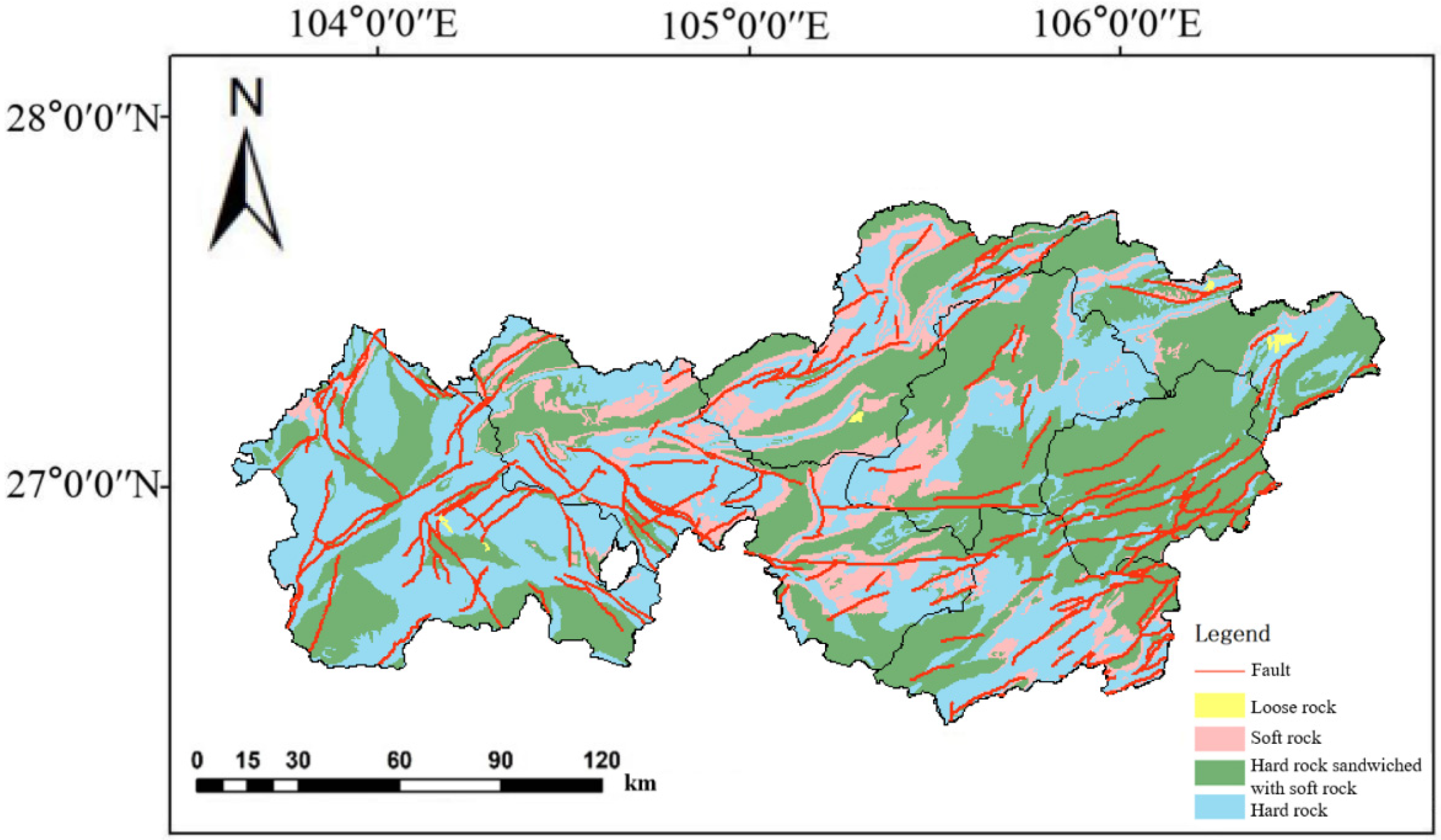
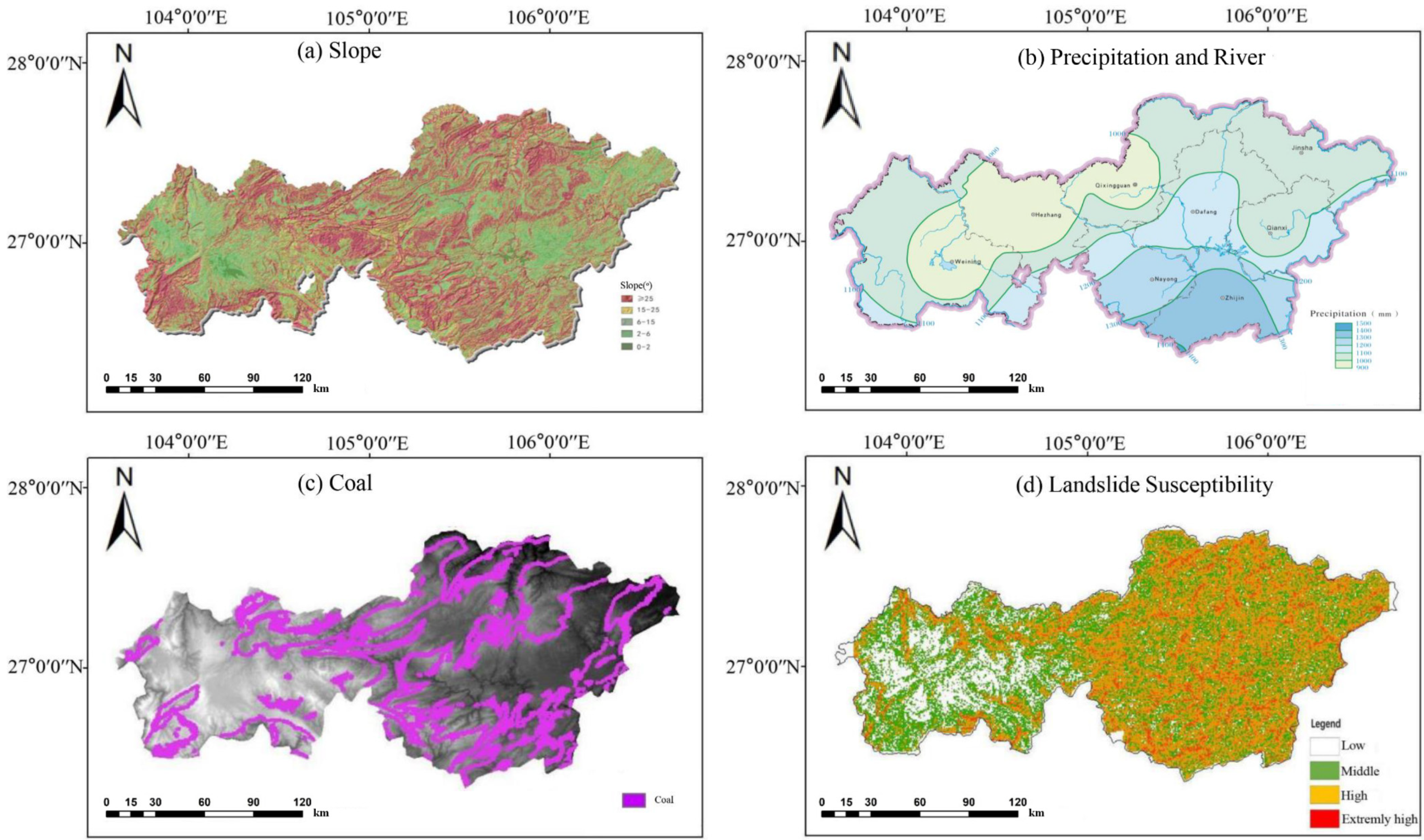
2.2.1. Geological Condition

The tectonic structure of Bijie City is located at the junction of the two global megatectonic domains, the Tethys-Himalaya and the marginal-Pacific tectonic system, and belongs to the southwestern margin of the Upper Yangtze Block within the first-level tectonic unit of the Yangtze Block. There are NE-trending, NW-trending, near-EW-trending faults, folds and other secondary faults (Figure 1). Its geomorphological manifestations are mainly linear boundaries of intermountain basins, fault triangles, linear valleys, etc. They are clearly visible in fault-controlled valleys, fault triangles and fault cliffs. The peak acceleration of ground motion in Bijie generally shows a decreasing trend from southwest to northeast, with 0.10 g on the southwest side and 0.05 g on the northeast side. In recent years, earthquakes of different magnitudes have occurred in Weining County, Hezhang County, Nayong County, Qixingguan and other places, causing a series of landslides.
According to field reconnaissance and comprehensive analysis of regional geological data, as well as rock and soil hardness, structure, and physical and mechanical properties, the rock formations in the study area are divided into four types: hard rock, hard rock sandwiched with soft rock, soft rock and loose rock (Figure 1). Hard rocks mainly include medium-thickness limestone, dolomitic limestone, dolomite, sandstone, etc. These rock formations are distributed in all counties and districts of Bijie City. These rocks are compact and hard in structure, with high mechanical strength of intact rocks, good engineering mechanical properties, and relatively low landslide susceptibility. Hard rock sandwiched with soft rock mainly includes carbonate rock sandwiched with mudstone, sandstone, shale, sandstone sandwiched with mudstone, etc. This type of rock formation is distributed in the entire area of Bijie City. The mechanical strength of this type of rock mass varies greatly, and most of them have weak interlayers. Under the condition of poor combination of strata, structure and terrain, it is easy to produce geological disasters such as landslides. Mudstones and shales, including sandstones, conglomerates, marls, etc., are mainly distributed in the central region. This rock group has weak weathering resistance, and the shallow parts of the surface are severely weathered, which can provide a large amount of material sources for landslides. Loose rocks are mainly clay, loam, sandy soil, loamy soil, and gravel soil. This rock group has a complex structure, loose, large porosity, strong water permeability and low strength. In areas such as inter-mountain valleys and riverbeds where the terrain is gentle, there are few geological disasters; in slope areas, under the influence of groundwater, rainfall, and human engineering activities, slope instability can easily occur, resulting in landslides and other geological disasters. Due to the complex geological conditions, rich mineral resources and intense human activities in the study area, landslides and other geological disasters frequently occur.

2.2.2. Forestry Change Data

The forestry change data provided by the Forestry Bureau of Bijie City show that in recent years, the tree-planting area in Bijie City has continued to expand, and the forest coverage rate has increased from 49.02% in Guizhou Province in 2016 to 54.19% in 2018. As shown in Figure 2, the forest structure comprises mostly woodland and shrubland, and the woodland stand structure is single, with an area of 770,782.36 hm2, accounting for 55.79% of the total forest area. The areas of other types of forest land, such as sparse forest land, undeveloped forest land, suitable forest land, nursery land, and forest land without standing trees, are small and scattered. The arbor forests in Bijie City are mainly plantations, which are artificially planted coniferous pure forests with simple hierarchies, poor biodiversity, unstable ecosystems, and a higher occurrence of natural disasters such as landslides [39].

2.2.3. Landslide Susceptibility Mapping

The landslide susceptibility data for Bijie City were provided by the Guizhou Provincial Mountain Geological Hazard Prevention Engineering Technology Research Center. These data originate from a database of hidden landslide danger points surveyed on the ground. According to a grid of 100 m × 100 m, the Bijie area can be divided into 2,394,053 cells, and the various influencing factors in the geographic information database can be rasterized and corresponding influencing factors can be assigned to each surface unit. In order to analyze the comprehensive superposition effect of geological conditions, rainfall, river distribution and other influencing factors on landslide susceptibility, influencing factors are selected based on the comprehensive consideration of natural and human factors. Human engineering activities include roads, mining areas, and land use, while geological environmental conditions include elevation, slope, plane curvature, slope aspect, profile curvature, lithology, rivers, rainfall, and fault zones. Then, the ArcGIS spatial overlay function is used to calculate the distribution density of hidden danger points of landslides with different influencing factors, and the information model is employed to calculate the information value of each influencing factor, and the information values are normalized to form a regional distribution map of various types of influencing factors. Two out of three sets of landslide hidden danger points identified in the field are selected as the training dataset, and the remaining set of landslide hidden danger points is selected as the verification dataset. The support vector machine (SVM) model in Python’s scikit-learn library is then called upon to calculate the weights of the 12 influencing factors. Using the obtained weights, grid algebra calculations are performed on the information about all influencing factors, the landslide susceptibility index of each surface unit in the study area is calculated, the results are obtained and drawn in ArcGIS, and an initial susceptibility evaluation of the study area is generated. The higher the value of the grid, the higher the susceptibility of the unit to landslides. Using the natural breakpoint method commonly used in statistics, the evaluation results were divided into four categories: low-susceptibility areas, medium-susceptibility areas, high-susceptibility areas, and extremely high-susceptibility areas. The middle-grade landslide-prone areas in Bijie City account for 30.21% of the city’s total area and the high-grade areas account for 41.30% of the city’s total area.
According to relevant research, among the 12 factors selected, the one with the greatest impact on landslide susceptibility is mining activities, and the other factors with a greater impact are the slope, rainfall, and distance to a river [40,41]. Among them, from Figure 3a,d, it can be seen that the distribution of slopes is consistent with the landslide-prone areas, and the slopes with low landslide-prone areas are generally not high. The distribution of rivers in Bijie is relatively uniform, and there is no obvious difference between east and west, but the annual rainfall in the east is greater (Figure 3b), which makes the east more susceptible to landslides. At the same time, coal mines in the eastern region are more widely distributed and mining activities are more intensive (Figure 3c). Under the combined effect of these factors, geological landslide disasters are more intensive in the eastern region. During the plant growth period, in the stratum with developed fissures, the growth of root system can lead to fissure expansion and root splitting. In clastic rock regions, root growth can mechanically break up the rock surrounding the roots, providing soil and nutrients. In the windy and rainy season, the tall trees have a loosening effect on the rock and soil at the root due to the dynamic action of the wind, which easily increases the susceptibility to landslides. At the same time, the root system of vegetation has the effect of strengthening the stability of the soil and slope. Therefore, whether vegetation factors can inhibit or promote landslides in the area remains to be studied. Geological conditions are the main factors affecting landslide susceptibility, while vegetation has less of an effect on landslides. However, the geological conditions are difficult to change in the natural state and can only be transformed through engineering activities. In contrast, vegetation is more plastic, and China is implementing afforestation activities. Quantifying the contribution of vegetation to landslides and selecting reasonable tree species and methods for afforestation can improve landslide susceptibility while restoring forests.

2.3. Methods

2.3.1. Contribution Evaluation Model

Plant roots are closely related to soil shock resistance and shear strength [42,43]. At the same time, different forests have different interception effects on atmospheric precipitation. In order to eliminate the impact of differences in forest areas, we quantitatively evaluated the relationship between forests and landslide susceptibility considering the aspects of forest land type, forest origin, age group, and dominant tree species. This paper is based on previous research results [44,45]. A normalized contribution evaluation model is constructed:
P(i, y) = 1/(1 + e(1 − (ALSM(i, y)/TALSM(i))/(ASEA(y)/TAREA)))
In the formula, i is the landslide susceptibility grade; y is the forest type; P(i, y) is the contribution of the i grade susceptibility to the y-type forest in the region, and the value varies from 0 to 1; ALSM(i, y) is the area of the y-type forest with the i-level vulnerability; TALSM(i) is the sum of the i-level vulnerability area in all forests in the region; ASEA(y) is the area of the y-type forest, and TAREA is the sum of the areas of all types of forests in the region.
When P(i, y) is closer to 1, the y-type forest contributes more to the i-level susceptibility; that is, the protection ability of this type of forest with respect to landslides is weaker. When P(i, y) is closer to 0.5, this indicates that the regional y-type forest does not contribute much to the i-level susceptibility. When P(i, y) is closer to 0, this indicates that the regional y-type forest contributes little to the i-level susceptibility; that is, this type of forest has a protective effect with respect to landslides.

2.3.2. Spatial Pattern Analysis

We collected the forestry change survey database information for eight districts and counties in Bijie City in 2019 from the Forestry Bureau of Bijie City and collected the landslide susceptibility evaluation results for Bijie City from the Guizhou Provincial Geological Disaster Emergency Technical Guidance Center. The ArcGIS spatial analysis module was used to extract the forest land type, forest origin, age group, and spatial location information of dominant tree species, and a spatial overlay analysis was performed using the landslide susceptibility data. Formula (1) was used to calculate the contribution of different types of forests to landslide susceptibility of different grades We quantitatively evaluated the relationship between forests and landslide susceptibility. Landslide susceptibility was divided into four levels: low, medium, high, and extremely high. Considering that landslides are less likely to occur for the low-susceptibility level, it is impossible to compare the contribution of different forest types. Therefore, we only analyzed the relationship between different forest types and medium and high levels, and extremely high-grade landslide susceptibility.

3. Results

3.1. Influence of Woodland Types on Landslide Susceptibility

Woodland and shrub forest land account for 98.49% of the total forest land area, and other types of forest land are small and scattered in Bijie City. Therefore, the contribution of woodland and shrubland to the landslide susceptibility of different grades is mainly discussed. The distribution of the landslide susceptibility of each grade in different forest land types is shown in Table 1 and Figure 4.
More than 50% of the forest land in Bijie City is woodland, with an area of 770,782 hm2. The landslide-prone areas of medium susceptibility, high susceptibility, and extremely high-susceptibility grades are 195,589 hm2, 297,205 hm2, and 221,121 hm2, and account for 52.94%, 56.42%, and 60.12%, of area of the corresponding landslide susceptibility grades, respectively (Table 1). The extremely high-grade landslide-prone areas are mainly distributed in the eastern part of Bijie, the high-grade landslide-prone areas are mainly in the central and eastern parts, and the medium-grade landslide-prone areas are most widely distributed in the western part (Figure 4a). In addition, the woodland has the greatest impact on the susceptibility of extremely high-grade landslide areas, with a contribution of 0.52. The contribution of the susceptibility of high-grade landslide areas is 0.50, and the impact on medium-grade landslide susceptibility is the smallest, with a contribution of 0.49 (Table 1). On the whole, the impact of woodland on the susceptibility to landslides of high susceptibility and extremely high-susceptibility grade areas is up to 0.5, which indicates an area prone to landslides.
The landslide-prone areas of high susceptibility and extremely high-susceptibility grades within the shrubland range were 219,637 hm2 and 144,049 hm2, accounting for 42% and 39% of area of the corresponding landslide susceptibility grades, respectively, mainly in the eastern part of Bijie City (Figure 4b); the landslide-prone areas of medium susceptibility grades were 148,250 hm2, mainly distributed in the central area. The contribution of shrubland to extremely high-grade susceptibility is 0.49, which is lower than that of woodland, indicating that the landslide susceptibility of shrubland is smaller than that of woodland; however, the contribution to high-grade landslide susceptibility is 0.51, which is higher than 0.5, indicating that the landslide protection ability is still not high.

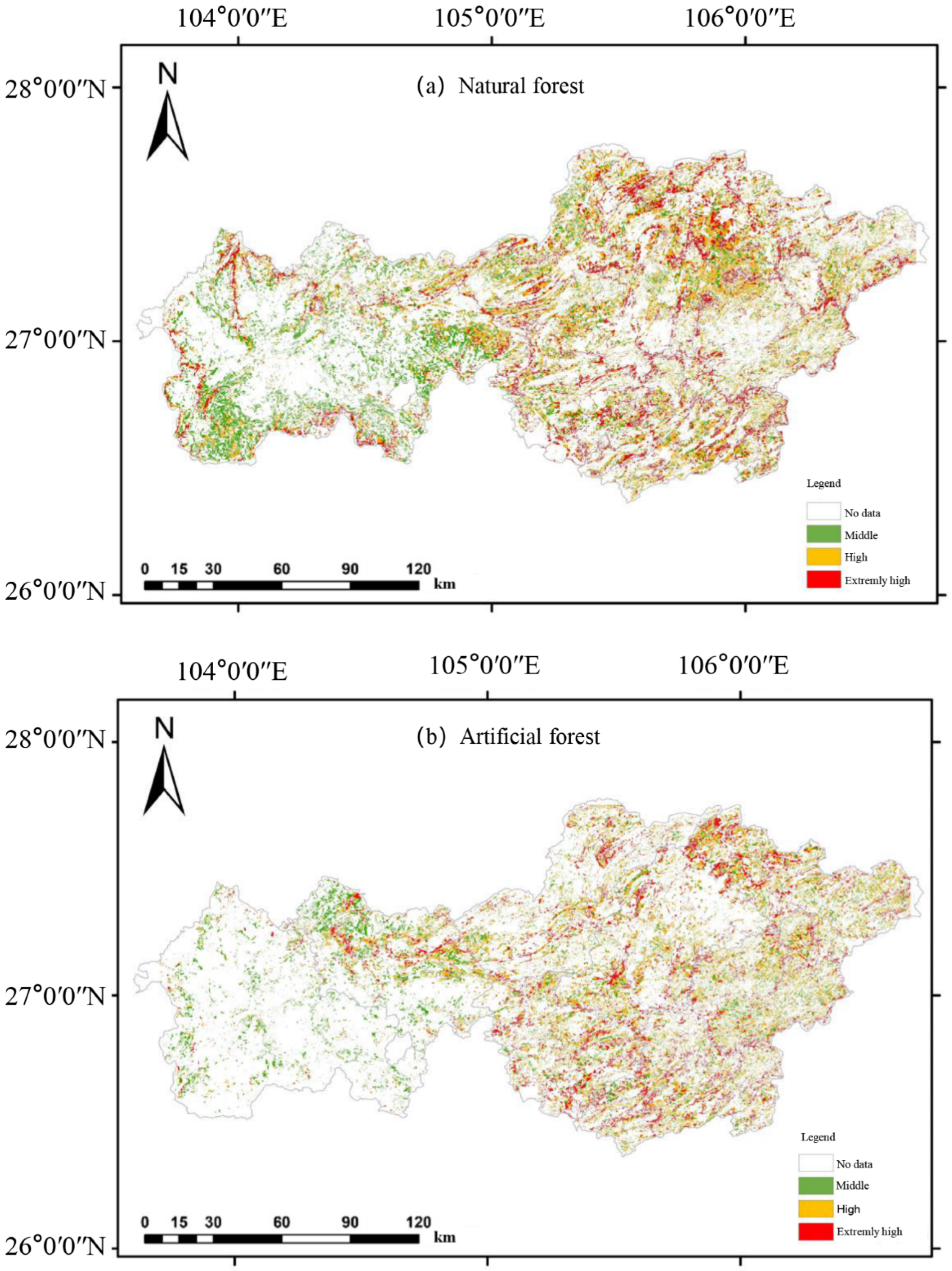
3.2. Forest Origin and Landslide Susceptibility

It can be seen from Table 2 and Figure 5 that the area ratio of natural forest to plantation forest in Bijie City is 3:2, and the natural forests with high and extremely high landslide susceptibility are mainly distributed in the central and eastern parts of Bijie City (Figure 5a). Plantation forests are mainly in medium-susceptibility areas and are less distributed in the west (Figure 5b). The landslide-prone area of high and extremely high grades within the natural forest land comprises 538,509 hm2, accounting for 62.28% of all natural forest land. The sum of the landslide-prone areas of high and extremely high grades within the plantation forest is 384,263 hm2, accounting for 66.62% of the total plantation area. The contributions of high- and extremely high-grade landslide susceptibility in the plantation forest are 0.52 and 0.51, respectively; the contributions for natural forest are 0.49 and 0.51, respectively, which are closer to 0.5. This shows that the plantation forest has weaker protection ability against landslides, while the landslide protection ability of natural forest is better than that of plantation forest.

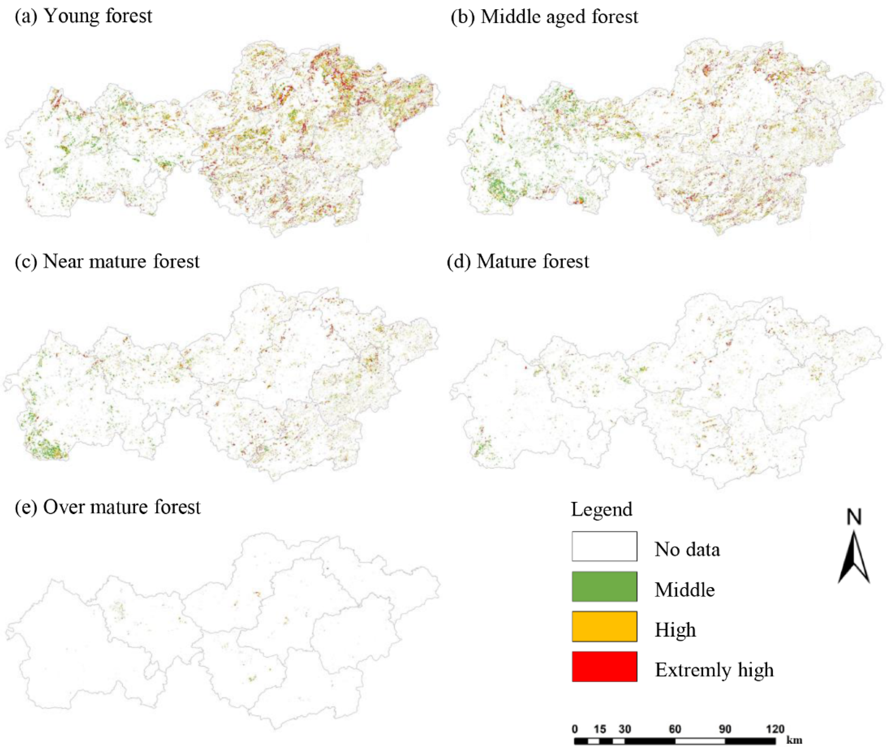
3.3. Forest Age Group and Landslide Susceptibility

It can be seen from Table 3 and Figure 6 that the areas of young- and medium-aged forests are the largest, accounting for 43.36% and 33.53%, respectively. Near-mature forests and mature forests account for 16.11% and 6.54%, respectively, and over-mature forests account for only 0.57%. The distribution of young-aged forests (Figure 6a) and medium-aged forests (Figure 6b) is similar, with high- and extremely high-landslide-susceptibility areas mainly distributed in the central and eastern areas, and the western areas being mainly medium-susceptibility areas. The medium-susceptibility areas of near-mature forests (Figure 6c) and mature forests (Figure 6d) are mainly concentrated in the western region, while high- and extremely high-susceptibility areas are scattered sporadically. Over-mature forests (Figure 6e) are small in area and are scattered in distribution. The contributions of young forest to high and extremely high landslide susceptibility are both 0.53, and the protection ability with respect to landslides is the weakest.

3.4. Dominant Tree Species and Landslide Susceptibility

Considering that Bijie City is located in the slope transition zone from the Yunnan Plateau to the Guizhou Plateau, the terrain is high in the west and low in the east. The natural geographical environment, such as the altitude, varies greatly among districts and counties [42]. Large differences and diverse geographical environments lead to different dominant tree species constituting arbor forest land in most districts and counties, and their forestry management strategies are also different. In order to improve the pertinence of the analysis of the impact of dominant tree species in arbor forest land on landslides and to guide the operability of forest management, in this paper, we used forestry change survey data to calculate the top-five dominant tree species in each county. We took a county as a unit (Table 4) to analyze the relationship between dominant tree species and landslide susceptibility, and to provide a reference for the region to formulate precise afforestation plans.

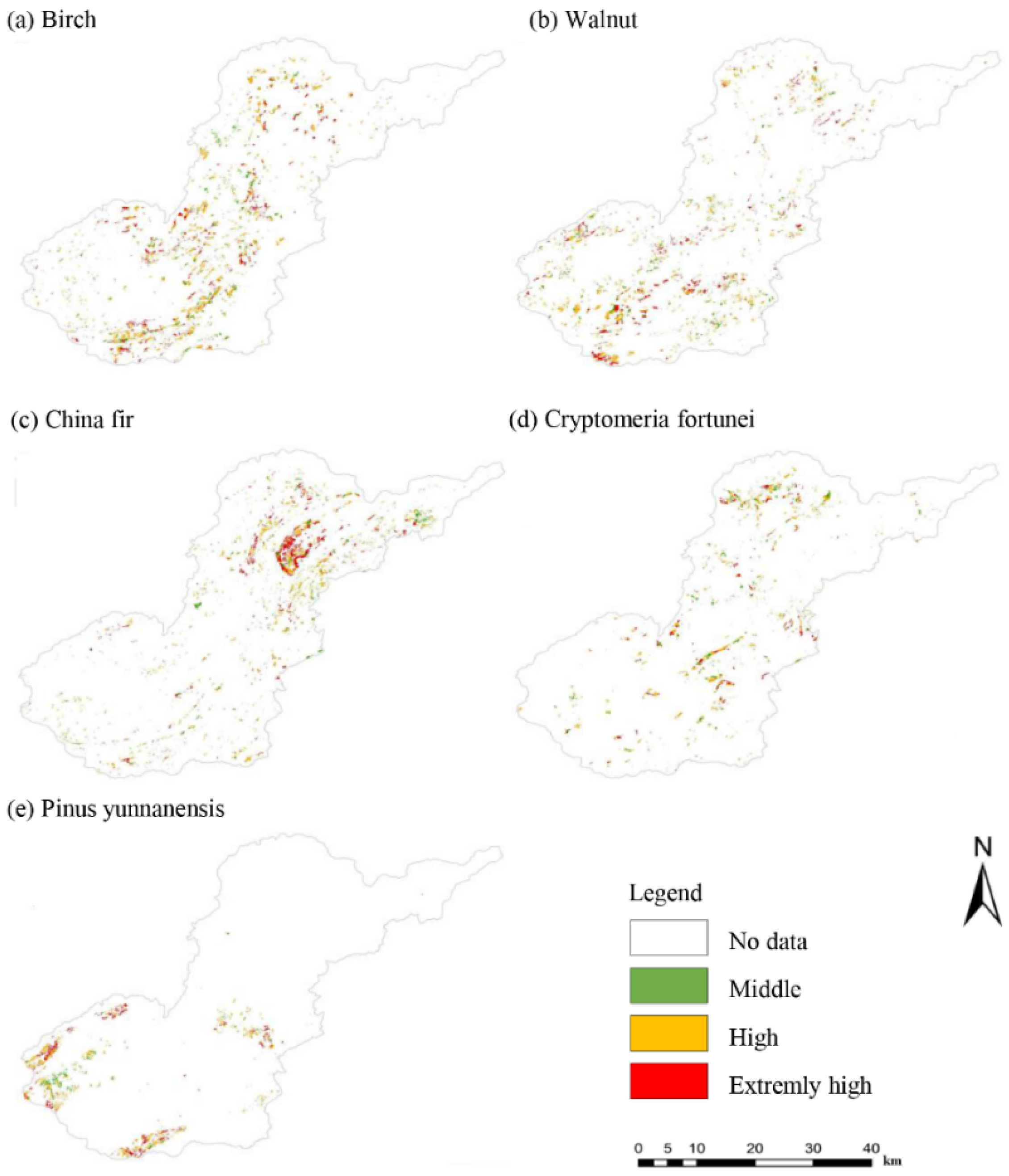
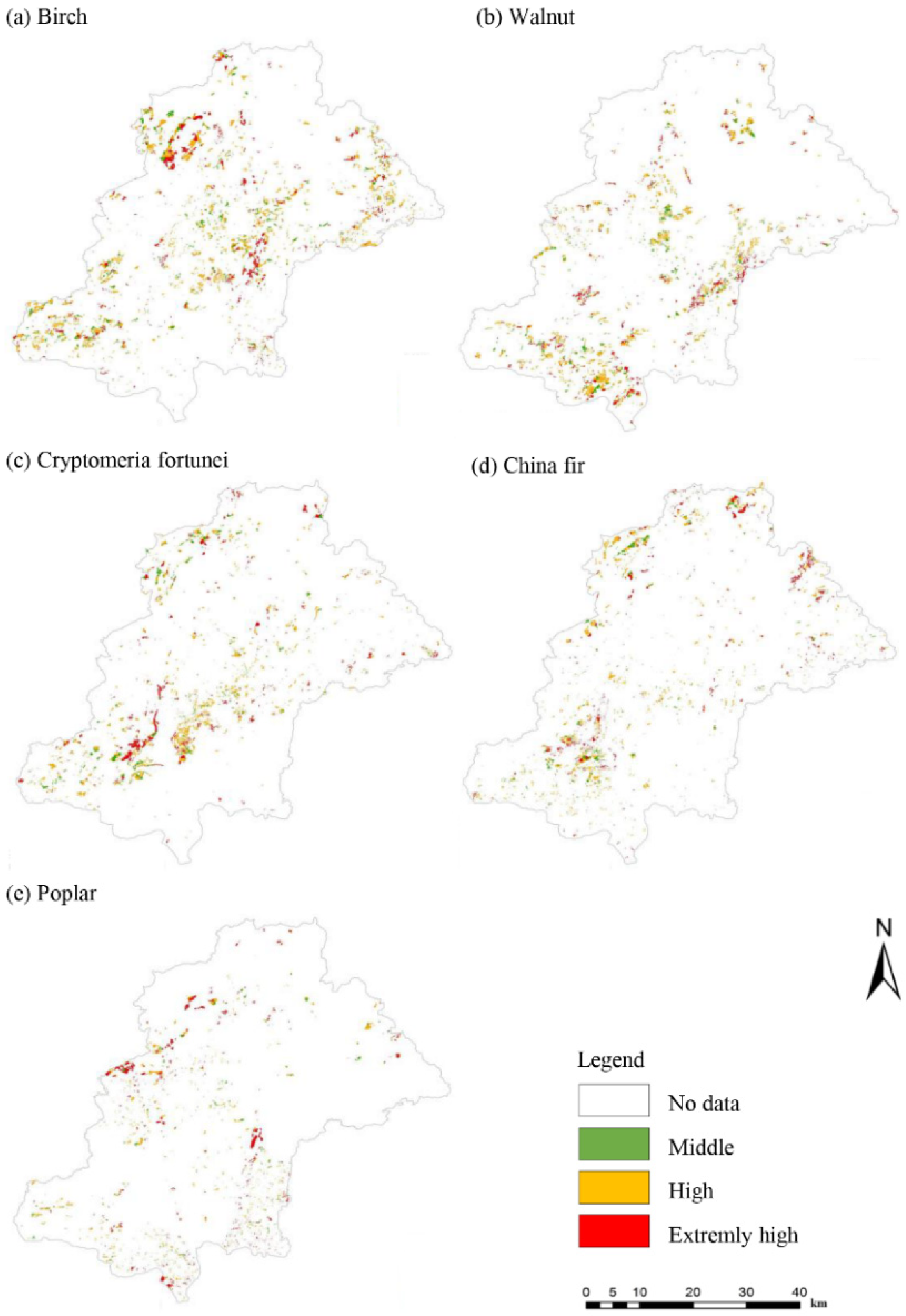
3.4.1. Dominant Tree Species and Landslide Susceptibility in Qixingguan District

It can be seen from Table 4 and Figure 7 that the top-five dominant tree species in the forests of Qixingguan District are Birch, Walnut, Chinese fir, Cryptomeria fortunei, and Pinus yunnanensis. The sums of high- and extremely high-grade landslide-prone areas for the various tree species are 11,451 hm2, 9706 hm2, 9690 hm2, 5903 hm2, and 5018 hm2, respectively, accounting for 79.8%, 79.9%, 79.8%, 74.9%, and 81% of the total areas of these tree species. Among the dominant tree species, Birch has the largest area, but it is less distributed in the southwest and northeast regions (Figure 7a); the areas with high and extremely high landslide susceptibility for Walnut are mainly in the southern region (Figure 7b); Chinese fir is more concentrated and is mainly distributed in the northern region (Figure 7c); Cryptomeria fortunei is scattered in a sporadic distribution (Figure 7d); Pinus yunnanensis has the smallest area and is distributed in sheets almost only in the south (Figure 7e).
Chinese fir makes the largest contribution to the susceptibility of extremely high-grade landslides, which is 0.55. The extremely high-susceptibility area is 4171 hm2, accounting for 34.4% of its own area, and the protection ability with respect to landslides is the lowest. The contributions of Walnut and Pinus yunnanensis to extremely high-grade landslide susceptibility are 0.51 and 0.51, indicating that Pinus yunnanensis and Walnut have low protection ability with respect to landslides. The contributions of Birch to high-grade landslide susceptibility are 0.53 and 0.52, and the protection ability with respect to landslides is not high. Chinese fir, Walnut, and Pinus yunnanensis have an impact greater than 0.5 on the susceptibility to extremely high grades, and the landslide protection ability is not as good as that of Birch and Cryptomeria fortunei.

3.4.2. Dominant Tree Species and Landslide Susceptibility in Dafang County

From Table 4 and Figure 8, it can be seen that the top-five dominant tree species in Dafang County are Birch, Walnut, Cryptomeria fortunei, Chinese fir, and poplar, and the sums of the high- and extremely high-grade landslide-prone areas of various tree species are 15,739 hm2, 11,024 hm2, 9588 hm2, 8182 hm2, and 5592 hm2, respectively, accounting for 79.9%, 79.4%, 79.4%, 81.6%, and 83.3% of the areas of these tree species. Among the dominant tree species, Birch is less distributed in the southeast and north (Figure 8a); Walnut is mainly distributed in the central area and the south (Figure 8b); Cryptomeria fortunei (Figure 8c) and Chinese fir (Figure 8d) are mainly concentrated in the west and north; poplar is less distributed in the north, and its extremely high-susceptibility area is mainly in the center (Figure 8e).
Poplar has the smallest area, accounting for 3.39%. Its contribution to extremely high-grade landslide susceptibility reaches 0.59, and it is the only tree species with an extremely high-grade landslide susceptibility of more than 0.5, indicating that poplar has the weakest landslide protection ability compared with other tree species. The areas of Birch and Walnut are the largest, accounting for 8.26% and 6.71%, respectively; their contribution to high-grade landslide susceptibility is the largest (0.52), and their protection ability with respect to landslides is not high. Cryptomeria fortunei and Chinese fir contribute 0.5 and 0.51 to the high-grade landslide susceptibility and are also prone to landslide. Except for Cryptomeria fortunei, the impact of other tree species on high- and extremely high-grade landslide susceptibility is more than 0.5. Relatively speaking, Cryptomeria fortunei has the lowest possibility of landslide.

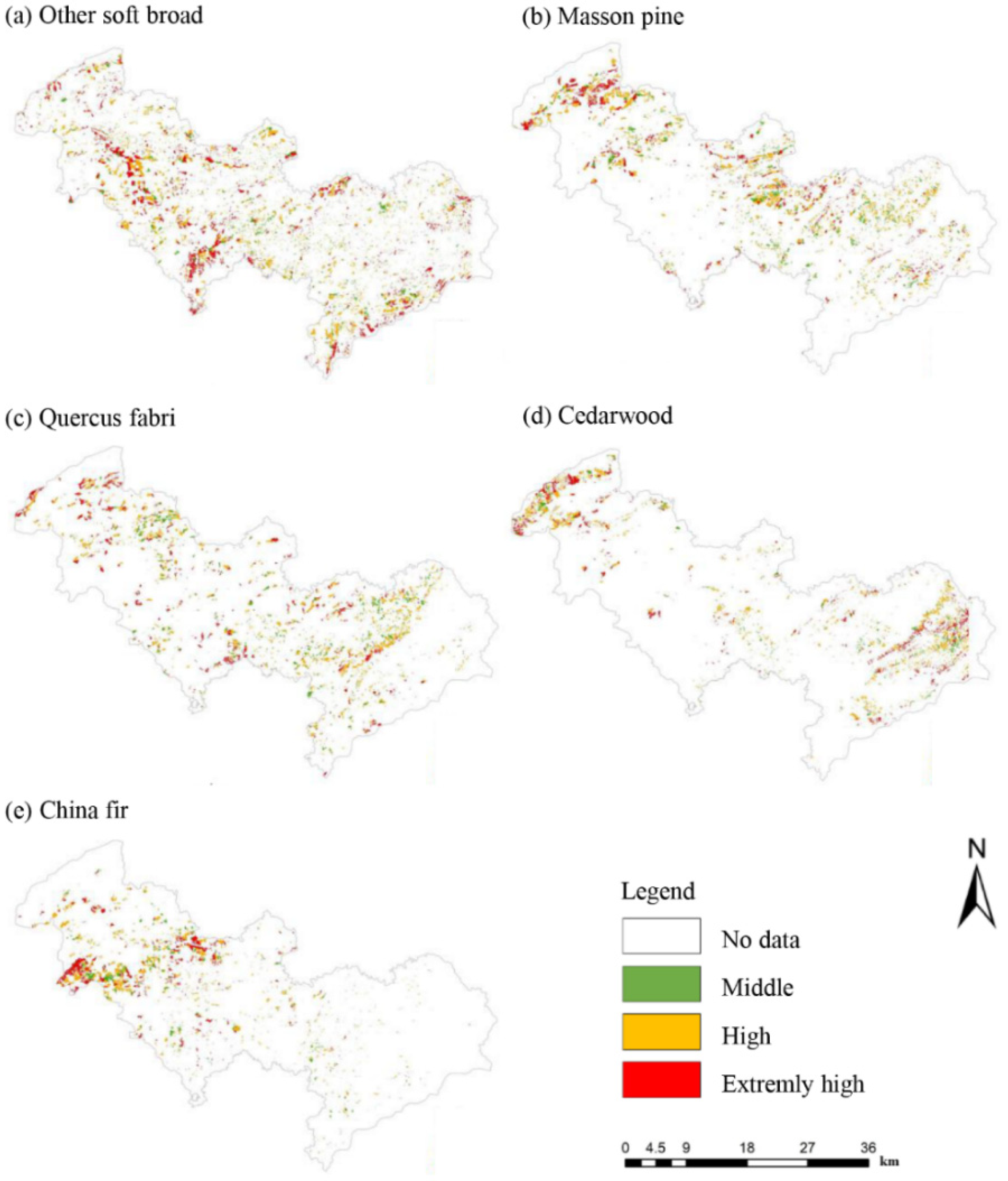
3.4.3. Dominant Tree Species and Landslide Susceptibility in Qianxi County

It can be seen from Table 4 and Figure 9 that the top-five dominant tree species in the forests of Qianxi County are Osmanthus trees, Masson pine, other soft broad tree species, Cedarwood, and Broad-leaved mixed tree species. The sums of high- and extremely high-grade landslide-prone areas are 35,402 hm2, 13,582 hm2, 9823 hm2, 8182 hm2, and 6771 hm2, accounting for 79.4%, 76.1%, 78.4%, 81.6%, and 76.2% of the areas of these tree species, respectively. The area of Osmanthus is much larger than that of other tree species, and the extremely high-grade landslide susceptibility area is more obvious in the marginal zone (Figure 9a); Masson pine is mainly concentrated in the central and northeastern parts (Figure 9b); other soft and broad tree species (Figure 9c), Cedarwood (Figure 9d), and broad-leaved mixed tree species (Figure 9e) are relatively small in area and are sporadically distributed.
Among the dominant tree species, the contribution of Osmanthus trees to the extremely high-grade landslide susceptibility is 0.55, and it is the only dominant tree species with an extremely high landslide susceptibility value greater than 0.5. Its extremely high-grade landslide-prone area comprises 14,409 hm2, accounting for 55.1% of the total extremely high-grade landslide-prone area, and its proportion is high, indicating that the Osmanthus has the lowest ability to protect against landslides. The contribution of other soft broad tree species and broad-leaved mixed tree species to high-grade landslide susceptibility is greater than 0.5, indicating that these tree species have poor protection ability with respect to landslides. Masson pine and Cedarwood species account for the lowest proportion of landslide-prone areas at high and extremely high grades, and their contribution to high and extremely high landslide susceptibility is relatively low, both less than 0.5, indicating that they provide relatively good protection against landslides.

3.4.4. Dominant Tree Species and Landslide Susceptibility in Jinsha County

It can be seen from Table 4 and Figure 10 that the top-five dominant tree species in Jinsha County’s forests are other soft broad tree species, Masson pine, Quercus fabri, Cedarwood, and Chinese fir. The sums of the landslide prone areas of various tree species with high and extremely high grades are 20,641 hm2, 14,606 hm2, 12,308 hm2, 10,188 hm2, and 9234 hm2, respectively, accounting for 84.6%, 80.6%, 79.3%, 85.4%, and 81.6% of the areas of these tree species. Other soft and broad tree species with the largest area have a large distribution in the whole county (Figure 10a); Masson pine is rare in the south, while the high-susceptibility area is most obvious in the west (Figure 10b); Quercus fabri is less distributed in the east (Figure 10c); Cedarwood is mainly found in the west and east (Figure 10d); fir is more abundant in the center, and the extremely high-susceptibility areas are also mostly in the center (Figure 10e).
Among the dominant tree species, the extremely high-susceptibility area of other soft and broad tree species makes the largest contribution of 0.54, and its extremely high-grade landslide-prone area is 9488 hm2, accounting for 35.1% of the total extremely highly prone landslide area; the landslide protection ability is the lowest. The contribution of Cedarwood to the landslide susceptibility of high and extremely high grades is 0.51, accounting for 8.92% and 8.94% of the total landslide susceptibility area of high and extremely high grades, respectively, and the landslide susceptibility is second only to other soft and broad tree species. The contribution of Masson pine and Quercus fabri to the high-grade landslide susceptibility is greater than 0.5, indicating that these tree species have low protection ability with respect to landslides. The area proportion of Chinese fir tree species in the landslide-prone area of high and extremely high grades is relatively low, and the contribution to the landslide susceptibility of high and extremely high grades is relatively low; it is not greater than 0.5. This shows that compared with other tree species, Chinese fir has relatively better protection ability against landslides.

3.4.5. Dominant Tree Species and Landslide Susceptibility in Zhijin County

From Table 4 and Figure 11, it can be seen that the top-five dominant tree species in Zhijin County are Cryptomeria fortunei, Chinese fir, Birch, other soft broad tree species, and Walnut. The sums of the landslide prone areas of various tree species with high and extremely high grades are 20,641 hm2, 14,606 hm2, 12,308 hm2, 10,188 hm2, and 9234 hm2, accounting for 80.7%, 81.1%, 81%, 82.5%, and 84.1% of the areas of these tree species, respectively. The distribution of Cryptomeria fortunei is relatively concentrated, with fewer areas in the north, and the high- and extremely high-susceptibility areas are mainly in the center (Figure 11a); Chinese fir (Figure 11b) and Birch (Figure 11c) are less distributed in parts of the north and northeast; other soft and broad tree species are more concentrated in the central aera of south (Figure 11d); Walnut has the smallest area and a scattered distribution (Figure 11e).
Among the dominant tree species, the extremely high-grade landslide-prone area of Walnut tree species comprises 3186 hm2, accounting for 42.2% of the area of this tree species. The contribution of Walnut to extremely high-grade landslide susceptibility is the largest, with a maximum contribution of 0.54 and the lowest landslide protection ability. Chinese fir and other soft broad tree species contribute 0.51 to extremely high-grade landslide susceptibility, with areas of 17,575 hm2 and 11,188 hm2, respectively. These tree species have low landslide protection ability. The influence of Cryptomeria fortunei and Birch on the high-grade landslide susceptibility is 0.51, which is higher than 0.5, indicating that the landslide protection ability of these tree species is not high, but they are more effective than the other three tree species.

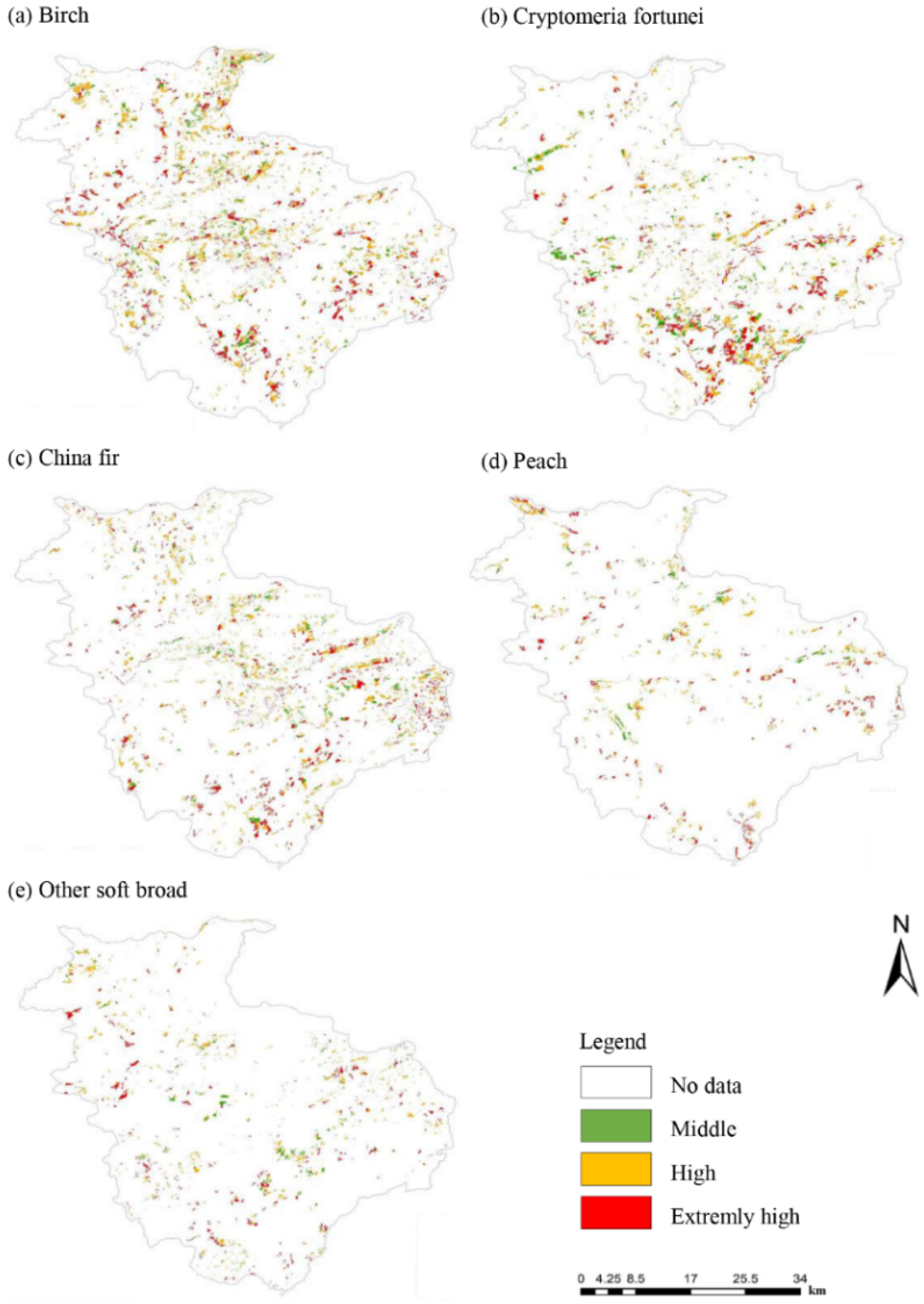
3.4.6. Dominant Tree Species and Landslide Susceptibility in Nayong County

It can be seen from Table 4 and Figure 12 that the top-five dominant tree species in the forests of Nayong County are Birch, Cryptomeria fortunei, Chinese fir, Peach, and other soft and broad tree species. The sums of the landslide-prone areas for various tree species with high and extremely high grades are 15,529 hm2, 11,992 hm2, 10,277 hm2, 5146 hm2, and 4703 hm2, respectively, accounting for 82.3%, 74%, 81%, 82.4%, and 76.6% of the areas of these tree species. Birch is widely distributed in the whole county (Figure 12a); Cryptomeria fortunei is mainly distributed in the central and southern areas (Figure 12b); Chinese fir is not as dense as in other areas in the west (Figure 12c); Peach (Figure 12d) and other soft broad tree species (Figure 12e) have the lowest area and a more sporadic distribution.
Among the dominant tree species in Nayong County, Peach makes the highest contribution to the landslide susceptibility of high and extremely high grades, being 0.53 and 0.51, respectively. The landslide protection ability is the worst, but its area is not large, accounting for only 4.61%. In addition, Chinese fir contributes 0.5 and 0.51 to the landslide susceptibility of high and extremely high grades, respectively, indicating that it is prone to landslides, and its ability to stop landslides is only better than that of Peach. The contribution of Cryptomeria fortunei and other soft and broad tree species to the extremely high-grade landslide susceptibility is 0.51, and the landslide protection ability is poor. The largest area of Birch species is 18,875 hm2, but its contribution to high landslide susceptibility is 0.53, and the landslide protection ability is not high; however, it is better than other tree species.

3.4.7. Dominant Tree Species and Landslide Susceptibility in Hezhang County

It can be seen from Table 4 and Figure 13 that the top-five dominant tree species in Hezhang County are Pinus armandi, Walnut, Pinus yunnanensis, Quercus fabri, and Chinese fir. The sums of the landslide-prone areas of the various tree species with high and extremely high grades are 14,786 hm2, 12,422 hm2, 7859 hm2, 4163 hm2, and 2223 hm2, respectively, accounting for 32.6%, 61.4%, 55.5%, 34.7%, and 60% of the areas of these tree species. The dominant tree species, Pinus armandi, has the largest area, is evenly distributed, and is mainly found in the medium-susceptibility area (Figure 13a). Walnut is mainly distributed in the central area (Figure 13b); Pinus yunnanensis is mainly distributed in the northwest (Figure 13c); Quercus fabri is small in area but concentrated in the south (Figure 13d); Chinese fir is scattered (Figure 13e).
The area of Walnut comes second, accounting for 10.2%, and the highest contributions to the susceptibility to landslides of high and extremely high grades are 0.63 and 0.68, respectively, indicating that its landslide susceptibility is the greatest. Pinus yunnanensis and Chinese fir contribute 0.57 and 0.56 to extremely high-grade landslide susceptibility, respectively, and contribute 0.62 and 0.60 to high-grade landslide susceptibility, indicating that their landslide protection capabilities are also poor. The contributions of Pinus armandi and Quercus fabri to the susceptibility to landslides of high and extremely high grades are lower than 0.5, indicating that their landslide susceptibility is low; at the same time, the area of Pinus armandi is 45,373 hm2, and the proportion reaches 22.87%. In general, the influence of Walnut, Pinus yunnanensis, and Chinese fir on the susceptibility to landslides of high and extremely high grades is much greater than 0.5, and the possibility of landslide events is high.

3.4.8. Dominant Tree Species and Landslide Susceptibility in Weining County

It can be seen from Table 4 and Figure 14 that the top-five dominant tree species in Weining County’s forests are Pinus yunnanensis, Pinus armandi, Sawtooth oak, Cyclobalanopsis glauca, and other soft broad tree species. The sums of the landslide-prone areas for the various tree species with high and extremely high grades are 24,153 hm2, 6376 hm2, 2194 hm2, 3235 hm2, and 1231 hm2, accounting for 24.3%, 13.2%, 21%, 73.8%, and 33.4% of the areas of these tree species, respectively. Pinus yunnanensis is concentrated in the southwest region (Figure 14a); Pinus armandi is less distributed in the west (Figure 14b); Sawtooth oak (Figure 14c) and Cyclobalanopsis glauca (Figure 14d) are small in area, and both are concentrated in parts of the north; the distribution of other soft broad species is sporadic (Figure 14e).
Among the dominant tree species, the area of Cyclobalanopsis glauca is 4381 hm2, accounting for 1.7%. Its contribution to extremely high-grade landslide susceptibility is 0.96, and it is the only tree species with a contribution close to 1 in all regions. It has the lowest protection ability against landslides and may even promote landslides. The contributions of other soft and broad tree species to the landslide susceptibility of high and extremely high grades are 0.56 and 0.57, indicating that the landslide protection ability is poor, but the tree species has the smallest area, 509 hm2, and the lowest proportion is 1.43%. Pinus yunnanensis has a large area with a proportion of 38.55%, which is larger than the sum of the other four tree species, and contributes 0.5 to high-grade landslide susceptibility. Its landslide protection ability is not high but is better than Cyclobalanopsis glauca and Pinus yunnanensis. The contributions of Pinus armandi and Sawtooth oak to the landslide susceptibility of medium, high, and extremely high grades is low, and neither exceed 0.5, indicating that their landslide protection ability is the best and is worthy of promotion.

4. Discussion

At present, research on the impact of forests on landslide susceptibility mostly focuses on the forest land type, origin, and forest root system, and concentrates on a single influencing factor. Few systematic studies have been conducted on forests, and the specific impacts of forests have not been quantified. By constructing a contribution model and combining the landslide susceptibility data in Bijie, we have quantified the contributions of forest type, origin, age, and dominant tree species to landslide susceptibility for the first time and deeply analyzed the impact of forests on landslides. We found that different forest types, origins, ages, and dominant tree species have different landslide susceptibilities.

4.1. Forest Types

Woodland has a higher landslide susceptibility than shrubland. Bijie City has a large proportion of coniferous forests represented by Pinus armandi and Pinus yunnanensis in the woodland. These kinds of trees have short root systems, single-tree stand structures, unstable ecosystems, thick soil layers for the growth of the forest, rich material sources for landslides, high centers of gravity, and easy lodging under the influence of rainfall and wind. These factors make the woodland more prone to landslides, which is contrary to the findings of Sun et al. [46]. This is because the soil layer in the karst area is thin and shrubland sites have a thin soil layer, less landslide material sources, and a low shrub height. Compared with tall trees, shrubland has a lower center of gravity, is less affected by rainfall and wind, and is less prone to lodging. Moreover, according to Li et al. [47], the soil moisture content can affect the runoff and slope stability. The distribution of water content in soil is also affected by plant species and root systems. Shrub roots can increase the water content and porosity in the rhizosphere soil; fine and medium roots provide the main channels for the formation of soil runoff, enhancing soil porosity and infiltration. Most of the fine roots of shrubs are on the soil surface, which can provide more water channels, promote infiltration, reduce surface soil moisture, and make the soil shear strength higher, which is conducive to slope stability. Therefore, the landslide protection ability of shrubland is relatively strong.

4.2. Forest Origin

The landslide susceptibility for artificial forests is greater than that of natural forests. According to forestry survey data, artificial forests include shallow-root arbor forests such as Pinus armandi and Pinus yunnanensis, and economic forests such as Walnut. Compared with natural forests, the stand structure of artificial forests is relatively simple, more disturbed by human activity, and less stable. The economic benefits are higher, but the ecological benefits of artificial forests are lower than those of natural forests. Under severe meteorological conditions such as heavy rain, plantations face a greater susceptibility of landslides; natural forests have a stronger soil fixation effect, and higher soil porosity enables them to better absorb rainfall and cope with other landslide factors; this is confirmed by Wang et al. [48]. This is because the root biomass per unit of soil in natural forests is much larger than that in artificial forests, and a large number of roots will be lost during transplanting, with some roots dying after transplanting. This will cause rainwater to fail to infiltrate in time when it rains, increase the soil moisture, soften the soil, reduce the adhesion and friction of soil particles, reduce the shear strength of the soil, and increase the susceptibility of landslides. At the same time, the soil will be turned over during the transplanting process, breaking the natural soil crust, making the surface moisture increase faster during rainfall, and reducing the adhesion of the soil. According to research results for soil samples collected from plantations and natural forests by relevant scholars, the proportions of soil aggregates in natural forests and plantations were 43.22% and 23.01%, respectively, indicating that the influence of natural vegetation on the aggregation of the soil structure is greater than that of plantations [28]. Therefore, the landslide protection ability of a plantation forest is reduced. As a result, in the establishment of plantations, the stand structure should be optimized, mixed forests should be planted, the combination of arbor and shrub should be reasonable, and plantation and ecological restoration should be carried out on the principle of imitating natural plant communities.

4.3. Forest Age

The landslide protection ability of forests in different age groups showed a trend of increasing first and then decreasing. Young forests have lower comprehensive efficiency, lower plant canopy density, fewer root systems, and fewer soil and water conservation functions. Under the influence of heavy rainfall, landslides are likely to occur and the protection ability with respect to landslides is weak. The protection ability of medium-aged forests against landslides is strong. This is because with the change from young forests to medium-aged forests, the stability of the forest land increases, the root system begins to develop gradually, the soil adhesion is stronger, and landslides cannot easily occur. The contribution was less than 0.5, which is consistent with the research results of Šilhán et al. and Sati et al. [49,50]. Near-mature forests provide the strongest protection against landslides. At this time, plant roots are developed, leaves are dense, respiration and transpiration are strong, roots absorb water from soil quickly, and infiltration of soil surface water is also faster, all of which can effectively reduce soil surface moisture, increase the soil shear strength, and reduce the landslide susceptibility. When the forest grows into mature forest and over-mature forest, the center of gravity of tall trees with dense canopies is higher than for the ground. Against the background of heavy rainfall and other extreme weather conditions, mature and over-mature forests are prone to lodging, thereby uprooting, and the soil stability declines. The protection ability with respect to landslides is weaker than that of near-mature forests, so the contribution of mature and over-mature forests is greater than 0.5, and their ability to prevent landslides is poor.

4.4. Dominant Tree Species

In terms of the impact of dominant tree species, artificial forests such as economic forests, other soft broad tree species, and shallow-rooted coniferous forests have limited inhibitory effects on landslides. Compared with near-mature forests, the slope stability of mature forests and over-mature forests in shallow-rooted arbor forests such as Chinese fir is reduced, and the probability of landslides is high. The dominant tree species in Qixingguan and Dafang are Chinese fir, Cryptomeria fortunei, and other coniferous species. Thus, the forest structure should be optimized and deep-rooted shrubs should be planted in steep-slope and high landslide-prone areas to increase the slope stability. Walnut, as a characteristic economic forest planted on a large scale in the process of poverty alleviation, has high economic benefits. However, due to frequent human activity and loose soil created in the process of economic forest management, it is easily affected by heavy rainfall and is prone to landslides. The dominant tree species in Hezhang and Weining counties is mainly Walnut. When planning and developing Walnut economic forests, attention should be paid to avoiding areas that are prone to landslides. Other soft broad tree species are widely planted in Qianxi County, Zhijin County, Nayong County, and Jinsha County. Compared with coniferous forests such as Chinese fir and Cedarwood, other soft broad tree species contribute more in extremely high landslide-prone areas and have weaker landslide protection capabilities. Consistent with the results of Bordoni et al. [23], this is because the average tensile strength of the roots of broad-leaved tree species is weak, and the enhancement effect on the soil shear strength is relatively poor. In particular, the area of soft broad tree species in Jinsha County is 24,385 hm2, a large proportion, covering 17.53% of the area. The extremely high-grade landslide susceptibility contributes the most, and landslides occur frequently, which should arouse the attention of the forestry department. It is notable that Cyclobalanopsis glauca trees are widely planted in Weining County, and most of them are distributed in mountainous areas with more gravel. The soil erosion is serious and, coupled with the steep terrain and abundant sources of weathered materials and other factors, the susceptibility of landslides is extremely high, which should arouse great attention from the forestry department.

4.5. Forest Management Strategy

In forestry planning and design and afforestation, landslide factors should be comprehensively considered, and the potential for landslide protection in the process of forest management should be brought into play. It is necessary to strengthen the protection and restoration of natural forests, gradually restore natural forests with high slopes and broken soils in areas prone to landslides, enhance the ability of natural forests to store water and soil, control soil erosion, reduce vegetation damage, protect the stability of the original ecosystem, and improve the landslide protection ability. This can be carried out by optimizing the plantation stand structure and following the principle of imitating natural plant communities in the process of afforestation, planting mixed forests, paying attention to the combination of arbor and shrub, and improving the diversity of plantation stands. For existing pure plantations, this should be based on the dominant tree species in different regions, combined with the distribution of landslide susceptibility. The forest stand structure should be transformed, plants that can stabilize the slope and prevent landslides should be added, the soil’s shear resistance should be improved, and ecosystem stability should be enhanced. When planting economic forests, it is necessary to avoid areas with high landslide susceptibility and pay attention to soil and water conservation.

5. Conclusions

We investigated the contributions of the woodland type, forest origin, forest age group, and dominant tree species to landslide susceptibility, and the results show that forests play a role in regulating landslide susceptibility. In general, natural forests have significantly stronger landslide protection capabilities than artificial forests, shrubland has stronger landslide protection capabilities than woodland, near-mature forests have stronger landslide protection capabilities than young forests and mature forests, and the dominant tree species in different regions have different effects on landslides. Among the dominant tree species in each county, the shallow-rooted coniferous forests represented by Chinese fir and Pinus yunnanensis, as well as the economic forests represented by Walnut, Peach, and Osmanthus, have a single stand structure, and most of them are plantations and young forests, which are highly susceptible to landslides. In forest management, it is necessary to optimize the stand structure according to the distribution of landslide susceptibility and take into account the organic unity of economic, social, and ecological benefits.

Author Contributions

All authors contributed to the study conception and design. Material preparation, data collection and analysis were performed by Y.Z., C.S., S.Z. and X.L. The first draft of the manuscript was written by Y.Z. and all authors commented on previous versions of the manuscript. All authors have read and agreed to the published version of the manuscript.

Funding

This research work was supported by the Outstanding Youth Science and Technology program of Guizhou Province of China ([2021]5615).

Institutional Review Board Statement

Not applicable.

Informed Consent Statement

Not applicable.

Data Availability Statement

Not applicable.

Acknowledgments

Thanks to Guizhou Provincial Mountain Geological Hazard Prevention Engineering Technology Research Center and Forestry Bureau of Bijie City for providing us with the data, which are important to our research.

Conflicts of Interest

We declare that this manuscript entitled “Analysis of the Influence of Forests on Landslides in the Bijie Area of Guizhou” is original, has not been published before and is not currently being considered for publication elsewhere. We confirm that the manuscript has been read and approved by all named authors and that there are no other persons who satisfied the criteria for authorship but are not listed. We further confirm that the order of authors listed in the manuscript has been approved by all of us. We understand that the Corresponding Author is the sole contact for the Editorial process. He is responsible for communicating with the other authors about progress, submissions of revisions and final approval of proofs.

References

  1. Li, Z.; Zhang, F.; Gu, W.; Dong, M.L. The Niushou landslide in Nanjing City, Jiangsu Province of China: A slow-moving landslide triggered by rainfall. Landslides 2020, 17, 2603–2617. [Google Scholar] [CrossRef]
  2. Stanley, T.; Kirschbaum, D.B. A heuristic approach to global landslide susceptibility mapping. Nat. Hazards 2017, 87, 145–164. [Google Scholar] [CrossRef] [PubMed] [Green Version]
  3. Salvati, P.; Petrucci, O.; Rossi, M.; Bianchi, C.; Pasqua, A.A.; Guzzetti, F. Gender, age and circumstances analysis of flood and landslide fatalities in Italy. Total Environ. 2018, 610–611, 867–879. [Google Scholar] [CrossRef] [PubMed]
  4. Hu, X.S.; Brierley, G.; Zhu, H.L.; Li, G.R.; Fu, J.T.; Mao, X.Q.; Yu, Q.Q.; Qiao, N. An exploratory analysis of vegetation strategies to reduce shallow landslide activity on loess hillslopes, Northeast Qinghai-Tibet Plateau, China. J. Mt. Sci. 2013, 10, 668–686. [Google Scholar] [CrossRef] [Green Version]
  5. China Government Network. National Geological Disasters in 2021 [EB/OL](2022-01-12) (2022-01-13). Available online: http://www.mnr.gov.cn//dt/ywbb/202201/t20220113_2717375.html (accessed on 13 January 2022).
  6. Ghestem, M.; Sidle, R.C.; Stokes, A. The influence of plant root systems on subsurface flow. Implications for slope stability. Bioscience 2011, 61, 86961. [Google Scholar] [CrossRef]
  7. Depicker, A.; Jacobs, L.; Mboga, N.; Smets, B.; Rompaey, A.V.; Lennert, M.; Wolff, E.; Kervyn, F.; Michellier, C.; Dewitte, O.; et al. Historical dynamics of landslide risk from population and forest-cover changes in the Kivu Rift. Nat. Sustain. 2021, 4, 965–974. [Google Scholar] [CrossRef]
  8. Grima, N.; Edwards, D.; Edwards, F.; Petley, D.; Fisher, B. Landslides in the Andes: Forests can provide cost-effective landslide regulation services. Sci. Total Environ. 2020, 745, 141128. [Google Scholar] [CrossRef]
  9. Kim, H.G.; Park, C.Y. Landslide susceptibility analysis of photovoltaic power stations in Gangwon-do, Republic of Korea. Geomat. Nat. Hazards Risk 2021, 12, 2328–2351. [Google Scholar] [CrossRef]
  10. Schmaltz, E.M.; Steger, S.; Glade, T. The influence of forest cover on landslide occurrence explored with spatio-temporal information. Geomorphology 2017, 290, 250–264. [Google Scholar] [CrossRef]
  11. Griffiths, J.W.; Lukens, C.E.; May, R. Increased forest cover and limits on clear-felling could substantially reduce landslide occurrence in Tasman, New Zealand. N. Z. J. For. Sci. 2020, 50. [Google Scholar] [CrossRef]
  12. Hwang, T.; Kangw, S.; Kim, J.; Kim, Y.; Lee, D.; Band, L. Evaluating drought effect on MODIS Gross Primary Production (GPP) with an eco-hydrological model in the mountainous forest, East Asia. Glob. Chang. Biol. 2008, 14, 1037–1056. [Google Scholar] [CrossRef]
  13. Dorren, L.; Schwarz, M. Quantifying the Stabilizing Effect of Forests on Shallow Landslide-Prone Slopes. In Ecosystem-Based Disaster Risk Reduction and Adaptation in Practice; Springer: Berlin/Heidelberg, Germany, 2016; pp. 255–270. [Google Scholar]
  14. Huang, G.; Zheng, M.; Peng, J. Effect of Vegetation Roots on the Threshold of Slope Instability Induced by Rainfall and Runoff. Geofluids 2021, 2021, 6682113. [Google Scholar] [CrossRef]
  15. Li, P.; Xiao, X.; Wu, L.; Li, X.; Zhang, H.; Zhou, J. Study on the Shear Strength of Root-Soil Composite and Root Reinforcement Mechanism. Forests 2022, 13, 898. [Google Scholar] [CrossRef]
  16. Peduzzi, P. Landslides and vegetation cover in the 2005 North Pakistan earthquake: A GIS and statistical quantitative approach. Nat. Hazards Earth Syst. Sci. 2010, 10, 623–640. [Google Scholar] [CrossRef]
  17. Jamal, M.; Mandal, S. Monitoring forest dynamics and landslide susceptibility in Mechi–Balason interfluves of Darjiling Himalaya, West Bengal using forest canopy density model (FCDM) and Landslide Susceptibility Index model (LSIM). Model. Earth Syst. Environ. 2016, 2, 1–17. [Google Scholar] [CrossRef] [Green Version]
  18. Davoudi, M.H.; Aghda, S.M.F.; Pour, G.R.S.A. Landslide stabilization by tree root reinforcement. WIT Trans. Ecol. Environ. 2004, 75, 39–45. [Google Scholar]
  19. Dias, A.S.; Pirone, M.; Urciuoli, G. Review on the methods for evaluation of root reinforcement in shallow landslides. In Advancing Culture of Living with Landslides, Vol 2: Advances in Landslide Science; Springer: Berlin/Heidelberg, Germany, 2017; pp. 641–648. [Google Scholar]
  20. Moos, C.; Bebi, P.; Graf, F.; Mattli, J.; Rickli, C.; Schwarz, M. How does forest structure affect root reinforcement and susceptibility to shallow landslides? Earth Surf. Process. Landf. 2016, 41, 951–960. [Google Scholar] [CrossRef]
  21. Kobayashi, Y.; Mori, A.S. The potential role of tree diversity in reducing shallow landslide risk. Environ. Manag. 2017, 59, 807–815. [Google Scholar] [CrossRef]
  22. Fan, C.C.; Su, C.F. Role of roots in the shear strength of root-reinforced soils with high moisture content. Ecol. Eng. 2008, 33, 157–166. [Google Scholar] [CrossRef]
  23. Tan, H.; Chen, F.; Chen, J.; Gao, Y.F. Direct shear tests of shear strength of soils reinforced by geomats and plant roots. Geotext. Geomembr. 2019, 47, 780–791. [Google Scholar] [CrossRef]
  24. Bordoni, M.; Cislaghi, A.; Vercesi, A.; Bischetti, G.B.; Meisina, C. Effects of plant roots on soil shear strength and shallow landslide proneness in an area of northern Italian Apennines. Bull. Eng. Geol. Environ. 2020, 79, 3361–3381. [Google Scholar] [CrossRef]
  25. Montgomery, D.; Schmidt, K.; Greenberg, H.; Dietrich, W. Forest clearing and regional landsliding. Geology 2000, 28, 311–314. [Google Scholar] [CrossRef]
  26. Tosi, M. Root tensile strength relationships and their slope stability implications of three shrub species in the Northern Apennines (Italy). Geomorphology 2007, 87, 268–283. [Google Scholar] [CrossRef]
  27. Facelli, J.M.; Temby, A.M. Multiple effects of shrubs on annual plant communities in arid lands of South Australia. Austral. Ecol. 2002, 27, 422–432. [Google Scholar] [CrossRef]
  28. Wang, X.; Huang, Z.; Hong, M.M.M.; Zhao, Y.F.; Ou, Y.S.; Zhang, J. A comparison of the effects of natural vegetation regrowth with a plantation scheme on soil structure in a geological hazard-prone region. Eur. J. Soil Sci. 2019, 70, 674–685. [Google Scholar] [CrossRef]
  29. Zhang, G.P.; Xu, J.; Bi, B.G. Relationship between landslide and debris flow hazards and environmental factors. Chin. J. Appl. Ecol. 2009, 20, 653–658. [Google Scholar]
  30. Iqbal, J.; Tu, X.; Xu, L. Landslide hazards in reservoir areas: Case study of Xiangjiaba reservoir, Southwest China. Nat. Hazards Rev. 2017, 18, 04017009. [Google Scholar] [CrossRef]
  31. Yang, D.; Qiu, H.; Zhu, Y.; Liu, Z.; Pei, Y.; Ma, S.; Du, C.; Sun, H.; Liu, Y.; Cao, M. Landslide Characteristics and Evolution: What We Can Learn from Three Adjacent Landslides. Remote Sens. 2021, 13, 4579. [Google Scholar] [CrossRef]
  32. Hua, F.Y.; Wang, L.; Fisher, B.; Zheng, X.L.; Wang, X.Y.; Yu, D.W.; Tang, Y.; Zhu, J.G.; Wilcove, D.S. Tree plantations displacing native forests: The nature and drivers of apparent forest recovery on former croplands in Southwestern China from 2000 to 2015. Biol. Conserv. 2018, 222, 113–124. [Google Scholar] [CrossRef]
  33. Wang, Q.; Yang, R. Study on REEs as tracers for late permian coal measures in Bijie City, Guizhou Province, China. J. Rare Earths 2008, 26, 121–126. [Google Scholar] [CrossRef]
  34. Wang, M.; Zhang, L.; He, Y.; Liu, L.; Chen, D.; Shan, A.; Feng, Y.; Yang, X. Soil fungal communities affect the chemical quality of flue-cured tobacco leaves in Bijie, Southwest China. Sci. Rep. 2022, 12, 2815. [Google Scholar] [CrossRef] [PubMed]
  35. Li, T. Research on Earthquake Disaster Risk Ssment Model and Its Application in Bijie City, Guizhou Province; Kunming University of Science and Technology: Kunming, China, 2015. [Google Scholar]
  36. Li, L.; Huang, M.; Liu, Z.J.; Xu, Q.Y.; Tong, X.J.; Lu, P.L. Landslide hazard risk assessment in Bijie area based on RS and GIS. J. Nat. Disasters 2011, 20, 177–182. [Google Scholar]
  37. Varnes, D.J. Slope movement types and processes. Spec. Rep. 1978, 176, 11–33. [Google Scholar]
  38. Cruden, D.M.; Varnes, D.J. Landslide types and processes. In Landslides-Investigation and Mitigation; Turner, K.A., Schuster, R.L., Eds.; National Research Council Transportation Research Board, Special Report; National Research Council: Washington, DC, USA, 1996; Volume 247, pp. 36–75. [Google Scholar]
  39. Xie, X.N.; Li, Y.C.; Liu, Y. Summary Report on Professional Investigation of Hidden Hidden Dangers of High-Level Hidden Geological Hazards in Guizhou Province; Guizhou Provincial Institute of Geological Environment Monitoring: Guiyang, China, 2019. [Google Scholar]
  40. Yao, K.; Yang, S.; Wu, S.; Tong, B. Landslide Susceptibility Assessment Considering Spatial Agglomeration and Dispersion Characteristics: A Case Study of Bijie City in Guizhou Province, China. ISPRS Int. J. Geo-Inf. 2022, 11, 269. [Google Scholar] [CrossRef]
  41. Shen, C.Y.; Feng, Z.K.; Xie, C.; Fang, H.R.; Zhao, B.B.; Ou, W.H.; Zhu, Y.; Wang, K.; Li, H.W.; Bai, H.L.; et al. Refinement of Landslide Susceptibility Map Using Persistent Scatterer Interferometry in Areas of Intense Mining Activities in the Karst Region of Southwest China. Remote Sens. 2019, 11, 2821. [Google Scholar] [CrossRef] [Green Version]
  42. De Baets, S.; Poesen, J.; Reubens, B.; Baerdemaeker, J.D.; Muys, B. Root tensile strength and root distribution of typical Mediterranean plant species and their contribution to soil shear strength. Plant Soil 2008, 305, 207–226. [Google Scholar] [CrossRef]
  43. Lee, J.T.; Chu, M.Y.; Lin, Y.S.; Kung, K.N.; Lin, W.C.; Lee, M.J. Root traits and biomechanical properties of three tropical pioneer tree species for forest restoration in landslide areas. Forests 2020, 11, 179. [Google Scholar] [CrossRef] [Green Version]
  44. Yu, K.Y.; Liu, J.; Yang, P.; Yao, X. Research on the relationship between forest management process and regional landslides. J. Cent. South Univ. For. Technol. 2016, 36, 5–10, 16. [Google Scholar]
  45. Kim, D.; Im, S.; Lee, C.; Woo, C. Modeling the contribution of trees to shallow landslide development in a steep, forested watershed. Ecol. Eng. 2013, 61, 658–668. [Google Scholar] [CrossRef]
  46. Fusun, S.; Jinniu, W.; Tao, L.; Yan, W.; Haixia, G.; Ning, W. Effects of different types of vegetation recovery on runoff and soil erosion on a Wenchuan earthquake-triggered landslide, China. J. Soil Water Conserv. 2013, 68, 138–145. [Google Scholar] [CrossRef]
  47. Li, J.; Wang, X.; Jia, H.X.; Liu, Y.; Zhao, Y.F.; Shi, C.M. Assessing the soil moisture effects of planted vegetation on slope stability in shallow landslide-prone areas. Soils Sediments 2021, 21, 2551–2565. [Google Scholar] [CrossRef]
  48. Phillips, C.; Hales, T.; Smith, H.; Basher, L. Shallow landslides and vegetation at the catchment scale: A perspective. Ecol. Eng. 2021, 173, 106436. [Google Scholar] [CrossRef]
  49. Šilhán, K. A new tree-ring-based index for the expression of spatial landslide activity and the assessment of landslide hazards. Geomat. Nat. Hazards Risk 2021, 12, 3409–3428. [Google Scholar] [CrossRef]
  50. Sati, S.P.; Sundiyal, Y.P. Role of some tree species in slope instability. Himal. Geol. 2007, 28, 75–78. [Google Scholar]
Figure 1. Geological condition map in Bijie City.
Forests 13 01136 g001
Figure 2. Spatial distribution map of forest land types in Bijie City.
Forests 13 01136 g002
Figure 3. (a) The slope distribution of Bijie; (b) the precipitation and river distribution of Bijie; (c) the coal mine distribution of Bijie; (d) landslide susceptibility.
Forests 13 01136 g003
Figure 4. Spatial distribution map of landslide susceptibility in shrubland in Bijie City.
Forests 13 01136 g004
Figure 5. Spatial distribution of forest origin and landslide susceptibility in Bijie City.
Forests 13 01136 g005
Figure 6. Spatial distribution map of forest age landslide susceptibility in Bijie City.
Forests 13 01136 g006
Figure 7. Spatial distribution map of landslide susceptibility of dominant tree species in Qixingguan District.
Forests 13 01136 g007
Figure 8. Spatial distribution map of landslide susceptibility of dominant tree species in Dafang County.
Forests 13 01136 g008
Figure 9. Spatial distribution map of landslide susceptibility of dominant tree species in Qianxi County.
Forests 13 01136 g009
Figure 10. Spatial distribution map of landslide susceptibility of dominant tree species in Jinsha County.
Forests 13 01136 g010
Figure 11. Spatial distribution map of landslide susceptibility of dominant tree species in Zhijin County.
Forests 13 01136 g011
Figure 12. Spatial distribution map of landslide susceptibility of dominant tree species in Nayong County.
Forests 13 01136 g012
Figure 13. Spatial distribution map of landslide susceptibility of dominant tree species in Hezhang County.
Forests 13 01136 g013
Figure 14. Spatial distribution map of landslide susceptibility of dominant tree species in Weining County.
Forests 13 01136 g014
Table 1. Relationship between forest land types and landslide susceptibility in Bijie City.
Forest land UseLandslide SusceptibilityThis Type of ForestContribution
MediumHighExtremely HighArea
(hm2)
Ratio
(%)
MediumHighExtremely High
Area
(hm2)
Ratio
(%)
Area
(hm2)
Ratio
(%)
Area
(hm2)
Ratio
(%)
Woodland195,58952.94297,20556.42221,12160.12770,78255.790.490.500.52
Sparse forest122.740.03129.440.0287.770.02372.260.030.570.490.48
Shrubland148,25040.13219,63741.69144,04939.17582,09142.70.500.510.49
Note: “Medium” refers to the medium-susceptibility area, “High” refers to the high-susceptibility area, and “Extremely High” refers to the extremely high-susceptibility area.
Table 2. Relationship between forest origin and landslide susceptibility in Bijie City.
Forest OriginLandslide SusceptibilityThis Type of ForestContribution
MediumHighExtremely HighArea
(hm2)
Ratio
(%)
MediumHighExtremely High
Area
(hm2)
Ratio
(%)
Area
(hm2)
Ratio
(%)
Area
(hm2)
Ratio
(%)
Natural221,32361.9323,31157.77215,19859.27864,55659.920.500.490.50
Artificial136,21038.1236,36442.23147,89940.73576,82140.080.490.520.51
Note: “Medium” refers to the medium-susceptibility area, “High” refers to the high-susceptibility area, and “Extremely High” refers to the extremely high-susceptibility area.
Table 3. Relationship between forest age groups and landslide susceptibility in Bijie City.
Age Grouplandslide SusceptibilityThis Type of ForestContribution
MediumHighExtremely HighArea
(hm2)
Ratio
(%)
MediumHighExtremely High
Area
(hm2)
Ratio
(%)
Area
(hm2)
Ratio
(%)
Area
(hm2)
Ratio
(%)
Young forest73,38037.52142,05547.889,79447.82334,18743.360.470.530.53
Medium aged forest71,28036.4591,32330.7360,35332.14258,41133.530.520.480.49
Near mature forest36,89618.8642,43814.2825,11513.38124,14416.110.540.470.46
Mature forest13,0376.6719,2906.4911,5336.1449,6126.440.510.500.49
Over mature forest9920.5120980.719660.5144290.570.470.560.47
Note: “Medium” refers to the medium-susceptibility area, “High” refers to the high-susceptibility area, and “Extremely High” refers to the extremely high-susceptibility area.
Table 4. Relationship between dominant tree species and landslide susceptibility in various districts and counties in Bijie City.
DistrictDominant Tree SpeciesLandslide SusceptibilityThis type of ForestContribution
MediumHighExtremely HighArea
(hm2)
Ratio
(%)
MediumHighExtremely High
Area
(hm2)
Ratio
(%)
Area
(hm2)
Ratio
(%)
Area
(hm2)
Ratio
(%)
Qixingguan Birch26117.5278059.0536467.1614,3428.060.480.530.47
Walnut20956.0361147.0935927.0612,1456.830.470.510.51
Chinese fir21406.1655196.441718.212,1406.830.480.490.55
Cryptomeria fortunei17625.0740934.7418103.5678784.430.540.520.45
Pinus yunnanensis10032.8931763.6818423.6261943.480.460.520.51
Dafang Birch355510.7210,63810.7351018.2619,6899.940.520.520.46
Walnut26087.8774947.5635275.7113,8907.020.530.520.45
Cryptomeria fortunei21996.6360396.0935495.7512,0736.10.520.500.49
Chinese fir17155.1751235.1730594.9510,0295.070.510.510.49
Poplar9552.8827722.828204.5767103.390.460.460.59
Qianxi Osmanthus 824531.6720,99331.114,40941.1344,56833.890.480.480.55
Masson pine384114.75914713.55443512.6617,85113.570.520.500.48
Other soft broad24219.365839.7532409.2512,5289.530.500.510.49
Cedarwood18927.2746086.8321636.1888886.760.520.500.48
Broad-leaved mixed forest18277.0247427.0318855.3886346.570.520.520.46
Jinsha Other soft broad330514.5311,15316.45948820.4924,38517.530.460.490.54
Masson pine328714.45927313.68533311.5118,12813.030.530.510.47
Quercus fabri288712.69794911.7243599.4115,52211.160.540.510.46
Cedarwood16237.1460458.9241438.9411,9168.570.460.510.51
Chinese fir17887.8655018.1137338.0611,2958.120.490.500.49
Zhijin Cryptomeria fortunei370713.63977813.6729112.0621,15012.980.510.510.48
Chinese fir294710.84750610.44675111.1717,57510.790.500.490.51
Birch24579.0467329.3651308.4814,6368.980.500.510.49
Other soft broad17856.5649626.942677.0611,1886.870.490.500.51
Walnut11374.1831684.431865.2775514.630.480.490.54
Nayong Birch286411.43899115.79653813.7418,87513.940.460.530.49
Cryptomeria334713.36623010.94576212.1116,20611.970.530.480.51
Chinese fir 20148.04579810.1844799.4112,6819.370.470.520.50
Peach10464.1729105.1122364.762434.610.480.530.51
Other soft broad10994.3924604.3222434.7161424.540.490.490.51
Hezhang Pinus armandi19,01625.8910,47519.6431118.745,37322.870.530.470.46
Walnut57557.83825015.43417218.120,24710.20.440.630.68
Pinus yunnanensis38695.27572110.721389.2814,1677.140.440.620.57
Quercus fabri46266.328355.313285.7612,0076.050.510.470.49
Chinese fir 14732.01160536182.6842762.160.480.600.56
Weining Pinus yunnanensis45,75143.4816,01138.91814229.1499,53338.550.530.500.44
Pinus armandi19,32618.37469411.4116826.0248,38418.740.500.400.34
Sawtooth oak37393.5514183.457762.7810,4684.050.470.460.42
Cyclobalanopsis glauca8490.8112583.0619777.0743811.70.370.690.96
Other soft broad14851.417221.755091.8236871.430.500.560.57
Note: “Medium” refers to the medium-susceptibility area, “High” refers to the high-susceptibility area, and “Extremely High” refers to the extremely high-susceptibility area.
Publisher’s Note: MDPI stays neutral with regard to jurisdictional claims in published maps and institutional affiliations.

