Article

Spatiotemporal Dynamics of Urban Green Space Influenced by Rapid Urbanization and Land Use Policies in Shanghai

1
College of Architecture and Urban Planning, Tongji University, Shanghai 200082, China
2
College of Surveying and Geo-Informatics, Tongji University, Shanghai 200082, China
*
Author to whom correspondence should be addressed.
Forests 2021, 12(4), 476; https://doi.org/10.3390/f12040476
Submission received: 24 February 2021 / Revised: 5 April 2021 / Accepted: 6 April 2021 / Published: 14 April 2021
(This article belongs to the Section Forest Ecology and Management)

Abstract

:
Urbanization has led to the continuous expansion of built-up areas and the ever-growing urban population, threatening the quantity and quality of urban green space (UGS). Exploring the spatiotemporal variations of UGS is substantially conducive to the formulation of land-use policies to protect the ecosystems. As one of the largest megacities all around the world, Shanghai has experienced rapid urbanization in the past three decades. Insights into how UGS changes in response to urbanization and greening policies are essential for guiding sustainable urban development. This paper employed integrated approaches to characterize the changing patterns and intensities of green space in Shanghai, China from 1990 to 2015. The spatiotemporal dynamics of the UGS pattern were derived through four main methods: green space ratio, dynamic change degree (DCD), transition matrix and landscape metrics. The results showed that Shanghai’s green space decreased from 84.8% in 1990 to 61.9% in 2015 while the built-up areas increased from 15.0% to 36.5%. Among the green space sub-types, farmland was largely encroached and fragmented by urban sprawl, especially in the Outer Ring Expressway and Suburban Ring Expressway belts of the city. About 1522 km2 of the green space has transferred into built-up areas, followed by farmland, waterbody, forest, and grassland in descending order. The 2000–2010 period witnessed the strong urban expansion and dramatic changes in UGS, but then the change around 2015 turned down and stable. The landscape pattern metrics showed that the entire green space in Shanghai was growingly fragmented and isolated during the past 25 years. Combined with the green space-related planning and policies issued in 1990–2015, the results revealed that both rapid urbanization and greening policies accounted for the spatiotemporal dynamics of UGS. Based on the results, some implicants to new urban planning and policies of Shanghai were highlighted.

1. Introduction

The global urbanization rate was predicted to reach 70% by 2050 [1]. The accelerated urbanization in the world has led to the ever-expanding built-up area and ever-shrinking urban green space (UGS) [2,3], causing ecosystem and environmental problems [4,5,6]. UGS is an important component of urban ecosystems, and its degradation disrupts the structure and process of urban ecosystems and affects urban sustainability. Increasing attention has been paid to the ecosystem service of UGS, including the improvement of microclimate regulation [7], mitigation of urban heat island effects [8], urban pollution controlling [9], providing aesthetic enjoyment and entertainment opportunities and maintaining well-being physically and psychologically [10].
Many countries and cities formulated greening policies and UGS planning actively to protect urban ecosystems and enhance the living quality of citizens [11,12]. For example, the United Kingdom and Brazil incorporated UGS planning into the urban planning system and issued corresponding planning policies since the 1990s [13,14]. The Maryland State Government of US established land protection programs to protect natural resources and developed Green Infrastructure Assessment to identify important ecological areas [15]. Great efforts also have been made in China in recent years to protect ecosystems. Especially the principle of ecological priority was insisted on in all land-use policies. For example, the ecological red lines controlling has become one of three important contents of the national spatial planning.
To assess the effects of rapid urbanization and land use policies on changes in UGS, many have studied the spatiotemporal dynamics and changing trend of UGS to help optimize their pattern and develop proper decisions to protect the urban ecosystem [16,17,18]. Satellite remote sensing techniques and geographical information systems (GIS) have been widely applied in recognizing the land-use changes over time [19,20]. A land-use transition matrix to reflect the transition among different land-use types in a specific period [21,22], and landscape metrics to measure the spatial changes of the landscape composition and configuration, were commonly used. In addition, a few studies have integrated gradient analysis with landscape metrics to quantitatively characterize green space patterns [23,24,25].
In recent years, the process of urbanization in China has been advancing rapidly, and a large amount of UGS has been occupied by urban construction. Shanghai, one of the megacities in the world, has undergone unprecedentedly rapid urbanization, in parallel with its economic boom since 1990 [26]. Its built-up area expanded from 876 km2 in 1995 to 2264 km2 in 2015 [27,28]. The rapid development has produced pressure on the UGS and accelerated the change of landscape patterns. Improving the ecological services of UGS became a common topic of concern to researchers and governments. Many studies have explored the spatiotemporal dynamics and drive factors of Shanghai’s green space on different scale levels and different periods [29,30,31,32,33]. In the meantime, Shanghai’s government developed urban master plans which have been updated three times since the 1980s, including the versions of 1986–2000, 1999–2020 and 2017–2035, and all of them had the contents related to UGS. In addition, the Shanghai UGS system plan (1994–2010, 2002–2020) [33] also had direct guidance for the development of UGS.
In this study, we applied the land use data of Shanghai to quantify the spatiotemporal dynamics of UGS from 1990 to 2015. We identified the spatiotemporal pattern and trend of UGS change in terms of rate, direction, gradient, land use transition and landscape pattern. This study aims to address three points: (1) the spatiotemporal pattern and changes of UGS in Shanghai during the past 25 years, (2) the discussion on the possible planning policies affecting changes in UGS, and (3) the suggestions to the Shanghai’s official urban plan to optimize the layout of UGS. Insights into this change and its driving factors therefore could benefit sustainable urban development and UGS protection in Shanghai [34].

2. Study Area and Datasets

2.1. Study Area

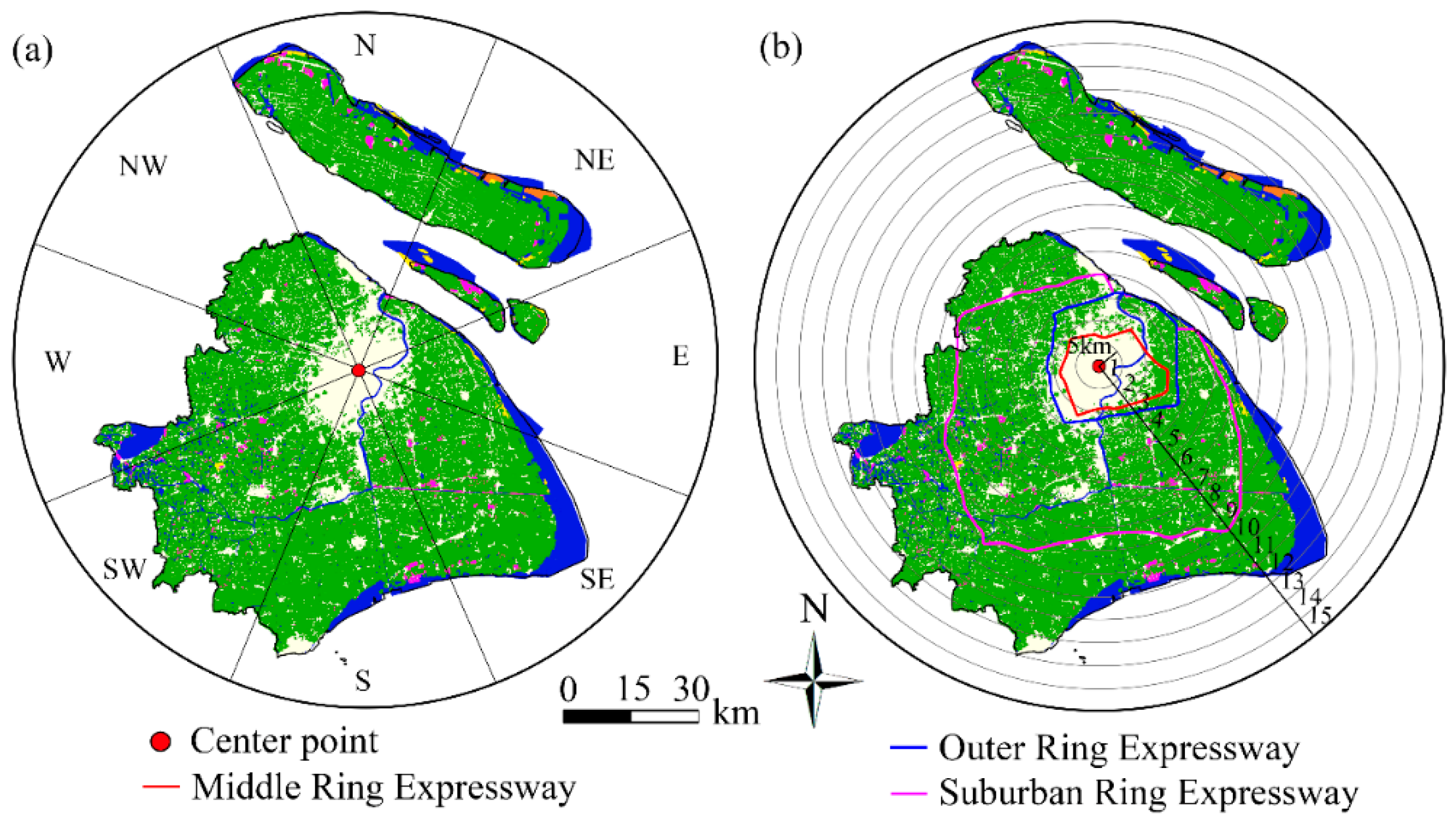
Shanghai, as the leading city of the Yangtze River Delta and the economic and financial center of China, is located in China’s eastern coast, covering an area of about 6340 km2 [35]. It is flat with the Huangpu River running through its heartland and is bounded by three ring roads, i.e., the Middle Ring Expressway, the Outer Ring Expressway and the Suburban Ring Expressway (Figure 1a).
With the development of the Pudong New Area, Shanghai’s economy has been growing rapidly since 1990. The population also increased from 13.3 million in 1990 to 24.2 million in 2015 [36], which promoted urban growth together with economic prosperity. Shanghai has become one of the fastest-growing and most densely populated cities in China and the world. The urban expansion has resulted in the fragmentation and reduction of UGS.
To prevent the loss of UGS caused by urbanization and maintain ecological security, Shanghai has recently proposed multi-level, networked and functional urban ecological space systems, which are composed of “a double-ring, nine ecological corridors, ten ecological conservation districts” as issued by the “Shanghai Urban Master Plan (2017–2035)” (Figure 1b). The double-ring belts indicate the green belt around the central area (outer ring green belt) and that around the far suburbs (suburban green belt). Green belts refer to green space to prevent the blind expansion of the city. This kind of belt can be scenic area, forests, etc. Ecological corridors refer to radial and unobstructed corridors in the city, which isolate urban clusters and realize interconnection with urban and rural ecological space, with the forest as the main body. In addition, the ecological network planning also includes multiple ecological intervals (vertical green belts that communicate and connect the city center and the surrounding green space, and restrict the continuous development of the city inside the Outer Ring Expressway) [37] and green wedges (wedge-shaped green space embedded in the city from the periphery of the city, like a city park or square) [38].

2.2. Datasets

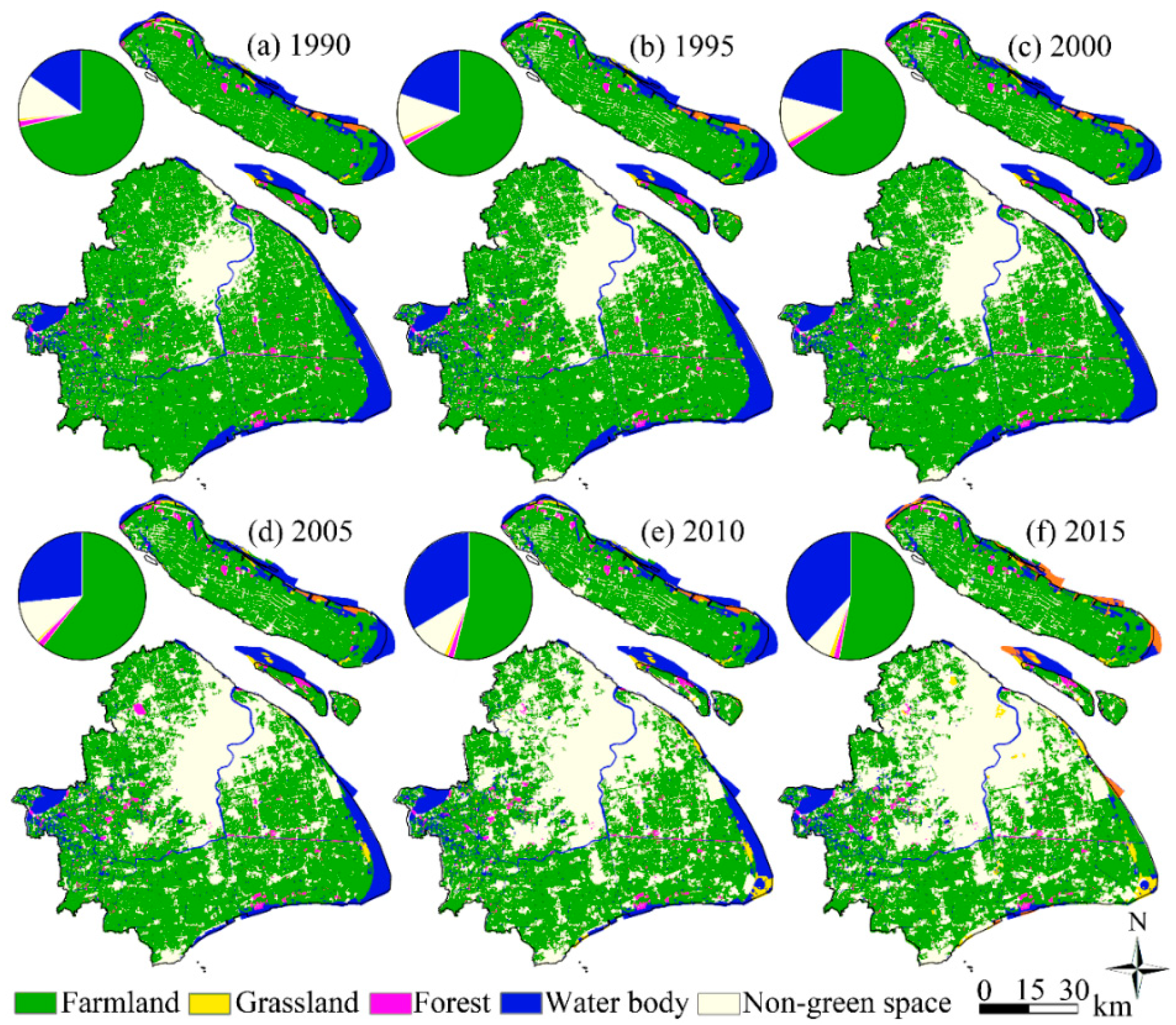
We used the land-use datasets interpreted from Landsat TM/ETM (National Aeronautics and Space Administration, Washington, DC, USA) and Landsat OLI (National Aeronautics and Space Administration, Washington, DC, USA) images for 1990, 1995, 2000, 2005, 2010, and 2015. The land-use datasets used in the research had already been supervised classified and widely used in published research [39,40,41]. The satellite images are classified using the supervised maximum likelihood classification method in ENVI 5.2 (https://www.l3harrisgeospatial.com/docs/whatsnew_envi52.html) (accessed on 24 February 2021) to generate land-use patterns and the overall accuracies of the classified land use data are above 97.3% [41]. Additionally, we reclassify the land-use into green space and non-green space (Table 1) according to the land use classification criteria of the Chinese Academy of Sciences [42]. The green space includes farmland (paddy field, dry land), forest (forest land, shrub, woods, others), grassland (dense grass, moderate grass, sparse grass) and waterbody (stream and rivers, lakes, reservoir and ponds, permanent ice and snow, beach and shore, swampland, bottomland), and the non-green space includes the built-up area (urban built-up, rural settlements, others), and unused land (Sandy land, Gobi, bare soil, bare rock, others). We then mapped the land use in Shanghai for 1990, 1995, 2000, 2005, 2010, and 2015 using ArcGIS 10.2 (Figure 2). Significant loss of green space and expanding built-up area can be clearly seen in Figure 2.

3. Methods

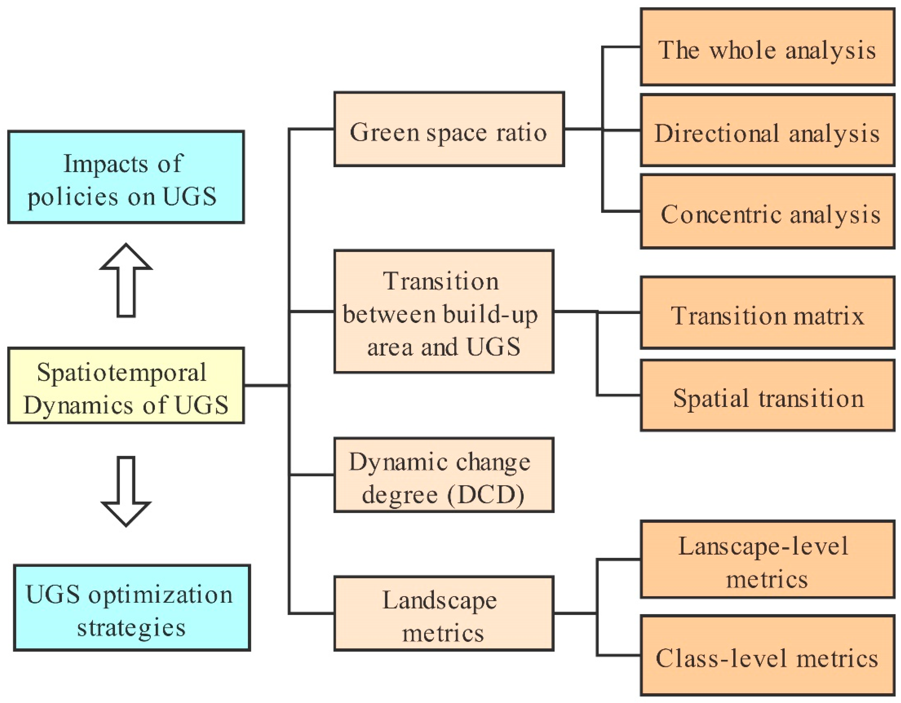
To analyze the spatiotemporal dynamics of UGS in Shanghai, we proposed an analysis method composed of four main parts (Figure 3).

3.1. Green Space Ratio

To deeply capture the spatiotemporal changes of UGS in Shanghai from 1990 to 2015, we analyzed the UGS in three aspects: quantitative changes of the whole city, eight directional changes and concentric buffer-based changes.
The directional and concentric analysis methods are effective for characterizing the quantity and spatial distribution of various types of UGS in terms of orientation and distance with respect to a pre-determined urban center [31,43]—in this case the People’s Square, the center of the circle. The directional analysis method can help to study the impacts of the urban construction in different directions on the green space and the concentric analysis can reflect the gradient changes of UGS from the dense urban construction area to vast suburban. We divided the study area into eight sectors, i.e., north, northeast, east, southeast, south, southwest, west and northwest (Figure 4a), for the directional analysis. While in the concentric analysis, the study area was divided into 15 concentric buffers from the center point with a width of 5 km (Figure 4b). Based on these two methods, we analyzed UGS changes and the green space ratio of each type. These were displayed on radar graphs and growth curves to show the spatiotemporal changes of the overall green space and its different subtypes in the eight directions or from the city center point to the boundary.

3.2. Land Use Transition Matrix

The land-use transition matrix reflects the structure and state of transitions of land-use types between every two periods [44]. By comparing the land-use patterns of two different periods pixel by pixel, we can identify the type and area transition of each land-use type. The land-use transition matrix can be given by [45]:
P = [ P 11 P 11 P 21 P 22 P 1 j P 2 j P i 1 P i 2 P i j ]
where Pij indicates the transitional area from land-use type i to type j, where each element in the matrix is characterized assuming that Pij is non-negative and j = 1 n P i j =1.

3.3. Dynamic Change Degree (DCD)

The DCD of UGS is a kind of land-use change rate index, which reflects the change density and rate of a certain green space type in a period [46]. The DCD of UGS can be calculated as [46]:
K = U b U a U a × 1 T × 100 %
where K indicates the DCD of UGS, Ua and Ub, respectively indicate the area of UGS at the start and end of a period, and T indicates the period in years.

3.4. Landscape Metrics

Landscape metrics are often used to detect and quantify the spatiotemporal changes in landscape composition and configuration [34,47,48]. In this study, we selected eight landscape metrics including five class-level metrics and three landscape-level metrics by referencing earlier work reported in many research (Table 2) [44,49]. They are used to reflect fragmentation, connectivity and diversity of landscape patterns [50]. The five class-level metrics include: percentage of landscape (PLAND) depicts the relative abundance of each land-use type; patch density (PD) represents the landscape fragmentation; large patch index (LPI), landscape shape index (LSI) illustrates landscape dominance and patch cohesion index (COHESION) reflects the connectivity in patches. Three landscape-level metrics are: contagion index (CONTAG) describes the aggregation degree of different patch types in the landscape, Shannon’s diversity index (SHDI) shows landscape diversity and heterogeneity, and Shannon’s evenness index (SHEI) describes the distribution of various patches in the landscape. Among these, PLAND, PD, LPI and LSI can represent fragmentation; COHESION and CONTAG reflect the connectivity in the green space sub-types and landscape, respectively; SHDI and SHEI can show the diversity.

4. Results

4.1. Composition Changes in Green Space

4.1.1. Green Space Ratio Changes during 1990–2015

Table 3 shows Shanghai’s green space area has been decreasing from 1990 to 2015, while non-green space has been increasing. The ratio of green space declined from 84.8% in 1990 to 61.9% in 2015 while the built-up area increased from 15.0% to 36.5%. Among the various types of green space, the loss of farmland was the most intense, the proportion of forest remained relatively stable, the grassland increased, and the waterbody showed an overall decreasing trend. Farmland experienced a substantial reduction from 71.3% to 52.9%, but still shared the largest proportion than any other type of Shanghai’s green space. Therefore, over 80% of the lost green space is contributed by the farmland. Forest kept relatively stable at 1.5%. Grassland declined at the beginning and then increased after 1995, especially during 2005–2015, when the grassland in 2015 increased to about twice in 2005. The area of water bodies remained stable before 2000, but had been continuously decreasing from 2000 to 2015.

4.1.2. Green Space Changes in Different Directions

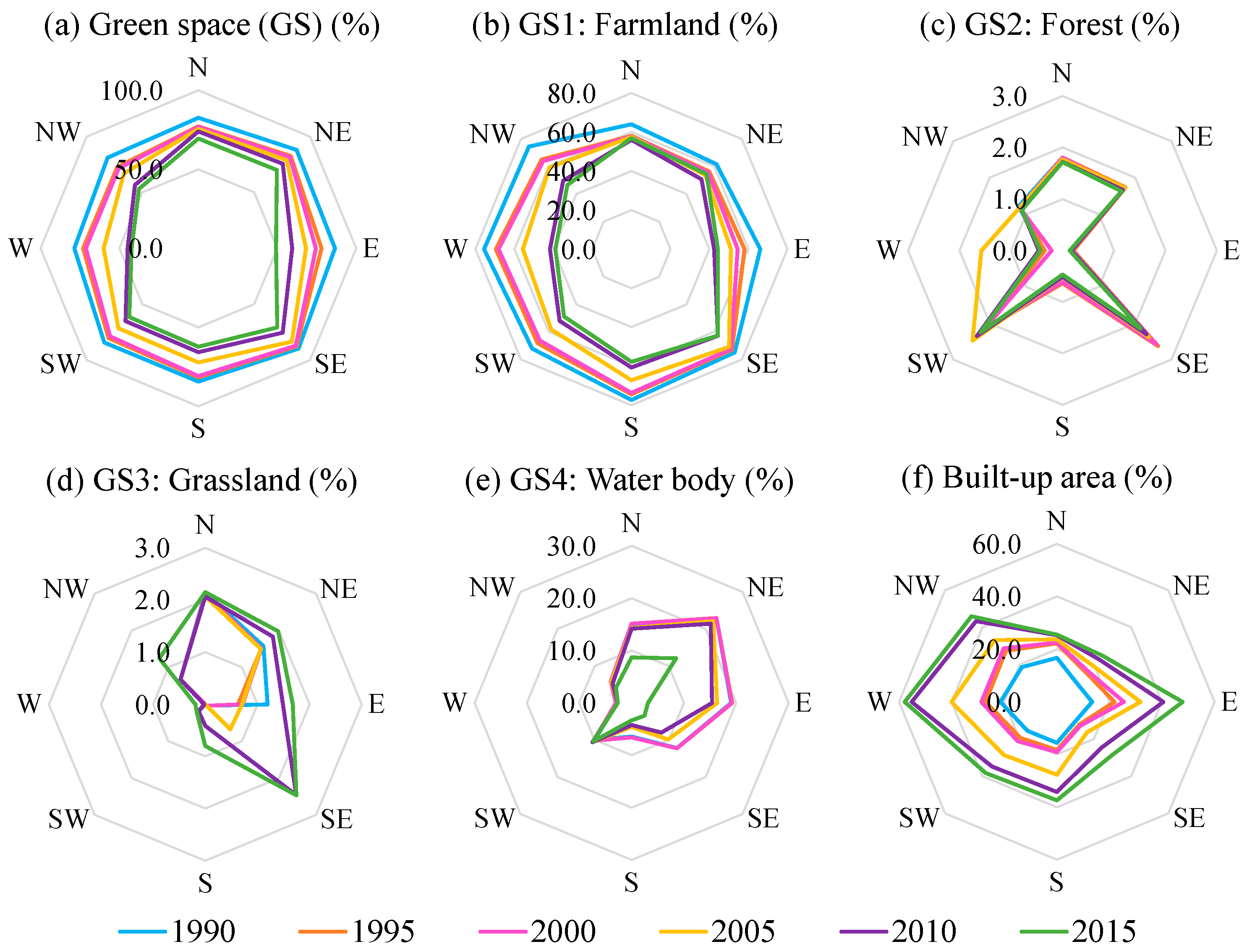
Figure 5 shows that the overall green space in Shanghai was evenly distributed in eight directions in 1990, but the distribution of subtypes of green space in eight directions in the city was quite different. The overall green space in all directions declined over time, and the changes of the four green space types in eight directions had significant differences.
In 1990, Shanghai’s green space accounted for similar areas in all directions, suggesting that the UGS was roughly evenly distributed, which may be greatly attributed to the farmland. With the rapid urbanization, the proportion of green space decreased in all directions from 1990 to 2015, especially in the east–west direction. The distribution and change of farmland were similar to the overall green space with a major loss in the east–west direction. In contrast, the built-up area shows substantial expansion in all directions, particularly in the east and west, indicating that encroachment on suburban farmland is the main way of Shanghai’s urbanization.
Forest changed slightly in all directions but was mainly distributed in the north (Chongming Island), the southwest (Sheshan National Forest Park) and southeast (Fengxian Forest park). The grassland is the only type that experienced an increase in all directions, and a notable increase was particularly observed in the southeast after 2005. Probably because Lingang New Town began to be developed. Water bodies are mainly located in the north to the east, where the Yangtze River runs through Shanghai in the north and Shanghai has a long coast in the east. However, the water bodies in the southeast and east reduced greatly, which may be attributed to the tidal flat reclamation, converting many sea areas to useable land. The water bodies in the northeast and north also showed an evident loss due to sediment deposition, leading to the inland expansion in the Chongming Island.

4.1.3. Green Space Changes along the Concentric Buffers

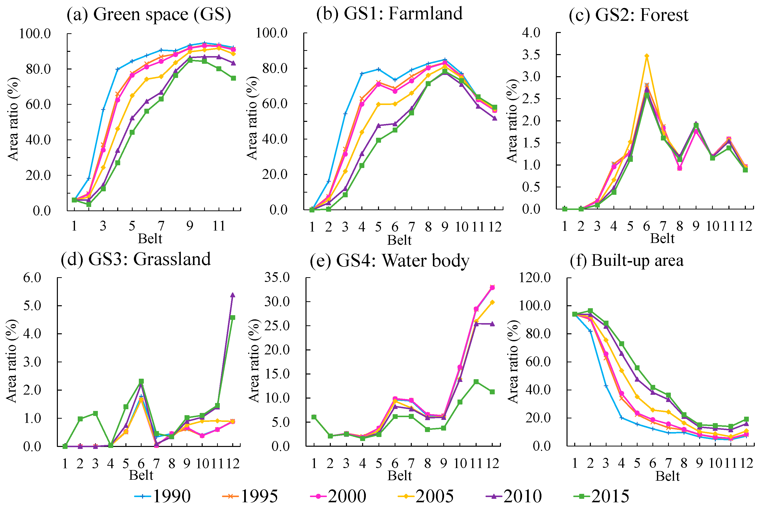
Since the mainland of Shanghai is enclosed in buffer 12 and green space changed significantly (Figure 4b), we focused on the UGS between Buffer-1 and Buffer-12 where built-up areas of Shanghai are mostly distributed in this study. The UGS and built-up area show an obvious gradient change with a reversal trend. Figure 6 shows that the green space ratio of each buffer increased rapidly from the city center to the suburbs, especially between Buffer-2 and Buffer-4, but tended to be stable outside of Buffer-9 because there are many satellite towns and new towns beyond Suburban Ring Expressway. From the time dimension of view, the green space ratio of each buffer continued to decrease from 1990 to 2015 with obvious growth of built-up area occurred, especially between Buffer-2 and Buffer-9.
The concentric buffers roughly parallel to the three ring-expressways in Shanghai. The Middle Ring Expressway is located between Buffer-2 and Buffer-3, the Outer Ring Expressway is located between Buffer-3 and Buffer-4, and the Suburban Ring Expressway spans from Buffer-5 to Buffer-9. The outer and suburban ring expressway zoned Shanghai into 3 belts. The center part inner the Outer Ring Expressway is the central city where the green space ratio is low and rises slowly. The green space especially farmland between the Outer and Suburban Ring Expressways was encroached by the built-up area. While the belt out of the Suburban Ring Expressway, waterbody and grassland are the main green space types, which shows the characteristic of “water village” in the Middle-Lower Yangtze Plain.
Among the green space sub-types, farmland dominated all zones outside of Buffer-3. Figure 6 shows that the spatiotemporal dynamics and distribution of farmland are similar to the total green space, because farmland takes up the highest proportion of green space. The farmland’s proportion shows an overall upward trend from Buffer-1 to Buffer-9, except from Buffer-6 where farmland decreases slightly. While outside of Buffer-9, the proportion of farmland shows a downward trend, and from 1990 to 2015 the farmland density of each buffer zones declines with time, especially in the regions between Buffer-3 and Buffer-7.
Grassland and water bodies have a higher rate in Buffer-6 because upstream of the Huangpu River and its Dazhi river runs along with this buffer with many wetlands. However, both of them increased quickly outside of Buffer-9, which means the typical water towns are well kept in this region. During 1990–2000, the grassland and water bodies changed minor in each buffer zones; whereas, after 2000, the proportion of grassland increased significantly from Buffer-10 to Buffer-12 while waterbody declined dramatically.
Forest is mainly concentrated around Buffer-6, where the over 500 m width green belt was developed since 1990 and many ecological corridors are distributed. However, it then declined away from the center city. It seemed that forest development had not been taken seriously.

4.2. Transitions between Green Space and Built-Up Area

The land-use transition matrixes (Table 4) reflect the spatiotemporal transition between the sub-types of green space and the built-up area. From 1990 to 2015, farmland was the sub-type of green space that transferred out most, of which 1428.3 km2 were converted into built-up area, accounting for 95.3% of the total loss of farmland. The transition from water bodies to the built-up area was also relatively large (73.0 km2), accounting for 25.4% of the transition of water bodies. The built-up area transferred from the forest was fewer (16.2 km2), but accounted for 81.0% of the losses of forest. The area transferred from grassland to built-up area was the least (4.6 km2). The transition was also found from built-up area to green space (26.3 km2), such as farmland and forest, and the quantity was generally increasing from 1990 to 2015.
The transition among different green space types was predominantly from water bodies to farmland. The past 25 years have witnessed 286.93 km2 reduction in water body, of which 59.8% were turned into farmland. With the increasing demand for urban space, tidal flats were considered the most important land reserves in Shanghai. Considerable tidal flats along the Pudong New Area’s coasts were developed and transferred into built-up area. Another feature was the increasing transitional area from farmland to forest and grassland after 2000. The transition area during 2010–2015 increased by more than 70 times of those during 2005–2010, which might be attributed to the implementation of the greening policy in Shanghai.
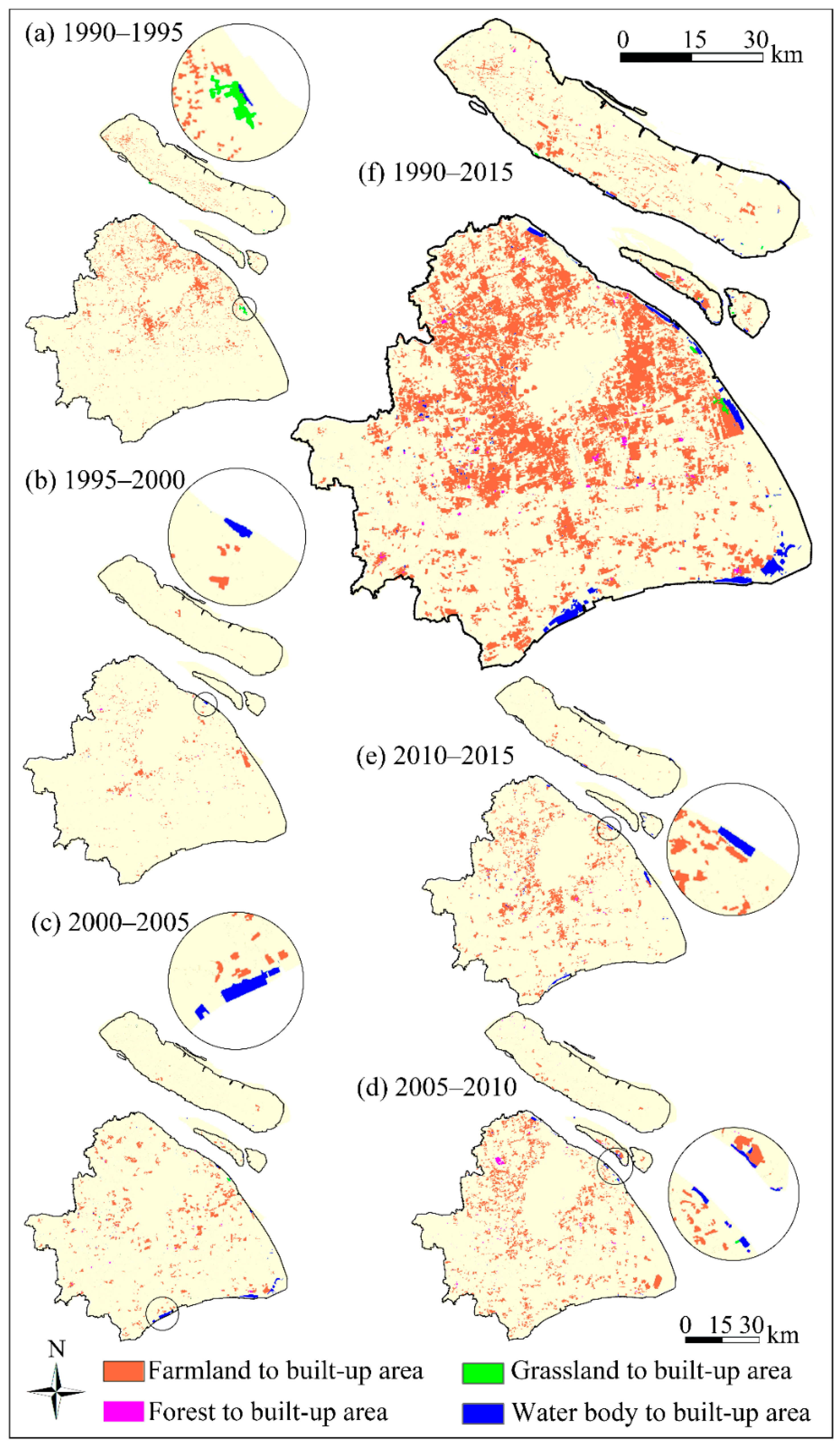
Figure 7 shows the spatial transition from the green space to the built-up area during 1990 and 2015, where the farmland around the urban fringes intensively was transferred into built-up area. The area under transition expanded outward, which revealed the encroachment of urbanization on farmland over time. The decrease of water bodies mainly occurred in the eastern and southern coastal area. The same result can also be drawn from Figure 5. However, the grassland and forest transferred to built-up area was distributed dispersedly. The built-up area exhibits a radial growth pattern from the city center to the fringes and small towns in far suburbs. The UGS increased greatly with the distance from the city center.

4.3. Dynamic Change Degree (DCD) of Green Space

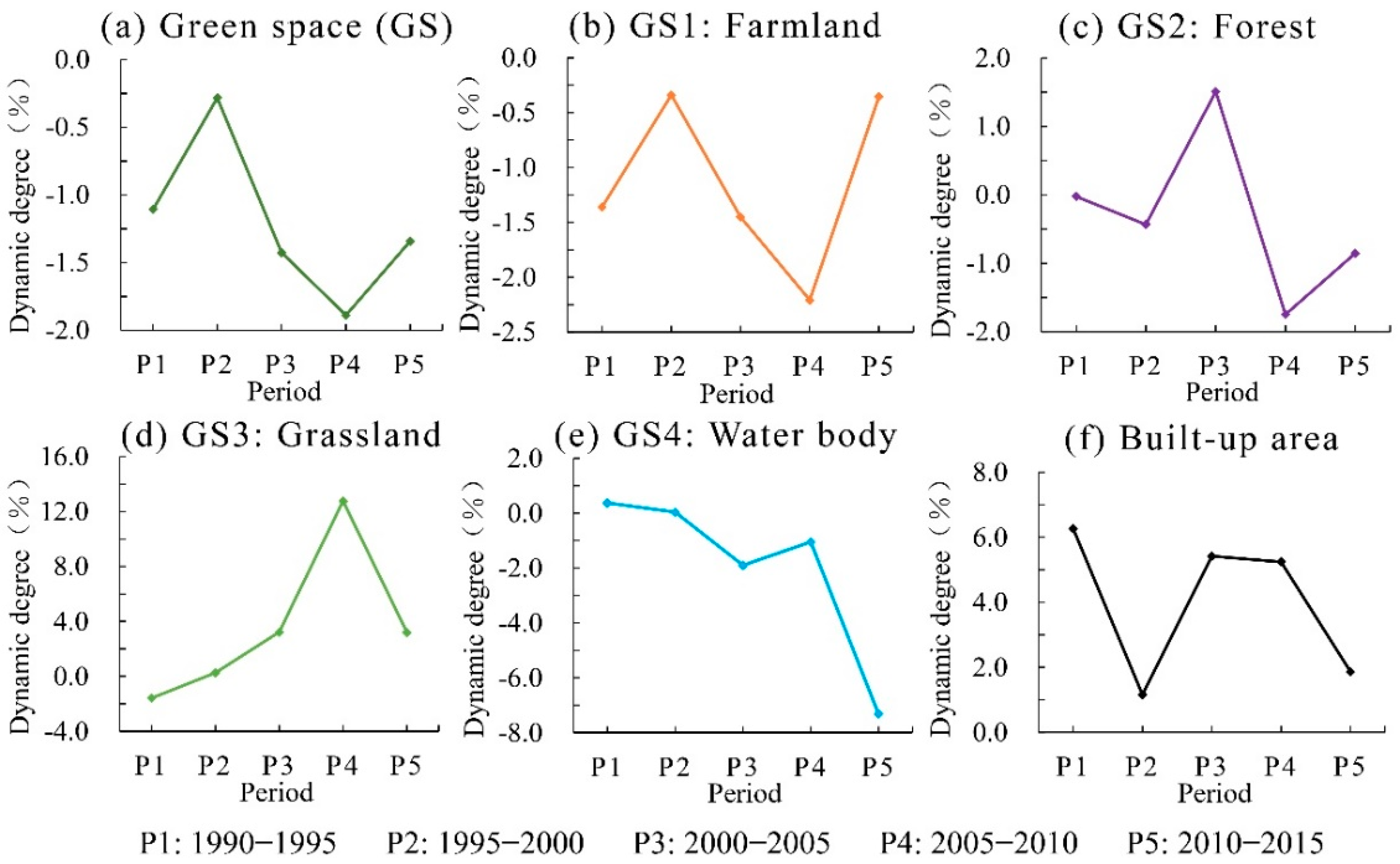
Figure 8 shows that the DCD was relatively small from 1995 to 2000 for the overall green space, but the reduction rate of green space rose during 2000–2010 while the built-up area always maintained a high growth rate. In the period of 2005–2010, DCD of green space, built-up area and sub-types of green space reached the highest point which witnessed strong urban expansion and green space change rate, and after 2010 the change rate of both the green space and built-up area turned down to be stable again. The result is a reflection of the urbanization process of shanghai. Shanghai experienced a quick development during 2000–2010, and then began to slow down the construction rate and emphasize high-quality development after 2010.
The DCD of the sub-types of UGS is quite different. Most importantly, farmland shows a similar trend as the overall green space. The dynamic degree of the forest was kept between −2% and 2% per year. Grassland got the fast increase rate to 14% per year during 2005–2010. However, every sub-type turned to be stable in the last period (2010–2015) except that the water bodies decreased sharply at 7.5%.

4.4. Green Space Changes in Landscape Patterns

We applied Fragstats 4.2 to calculate the landscape-level metrics of the entire landscape, that is, all land-use types (forest, grassland, farmland, waterbody, build-up area, unused land). The contagion index (CONTAG) shows a consistent decreasing trend in Figure 9a. The negative trend of CONTAG suggested high landscape fragmentation and low landscape connectivity in Shanghai. As shown in Figure 9b,c, Shannon’s diversity index (SHDI) and Shannon’s evenness index (SHEI) have been increasing during 1995–2015. The increasing SHDI and SHEI of green space indicate the increase of landscape fragmentation because of the rapid urban expansion and the reduction of the originally dominant land-use type (farmland). These in turn strengthened the relative balance of various landscape patches.
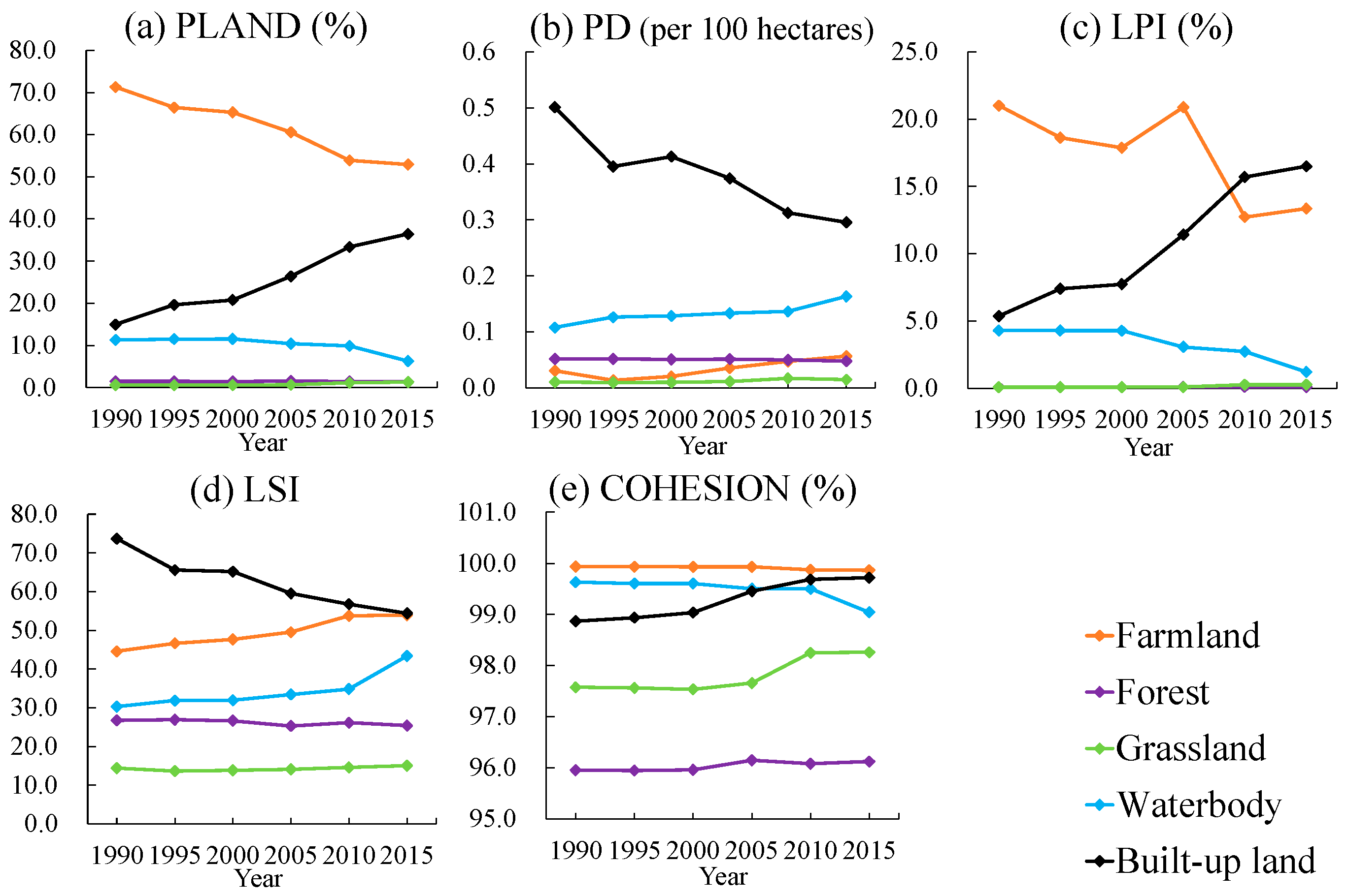
We used Fragstats 4.2 to calculate every class-level metric of UGS (forest, grassland, farmland, waterbody) and built-up area. Figure 10 shows the changes in the class-level metrics for all sub-types of the UGS during 1990–2015, where the farmland remained the dominant according to percentage of landscape (PLAND) and large patch index (LPI). However, the urban land use pattern changed dramatically in response to the continuous interference of human activities (e.g., urban development and construction). The increasing patch density (PD) for farmland indicates that the urban development accompanying by rapid urbanization has resulted in the fragmentation of farmland. The patch cohesion index (COHESION) of farmland kept steady and relatively higher than other sub-type, which means good connectivity between the farmland patches. The increasing Landscape shape index (LSI) indicates the gradual complexity of farmland patches and a decrease in their aggregation. During the study period, the built-up area became another dominant landscape type in Shanghai as revealed by higher LPI of built-up area compared to farmland since 2010.
PD and LSI of forest decreased while COHESION increased, which might be attributed to the artificial forests (e.g., the Shanghai Bay National Forest Park) that promoted the aggregation and connectivity of the forests. The increasing PD and LSI of grassland suggest that grassland was interfered out due to intensive human activities. For water bodies, the PD and LSI show an upward trend while the LPI and COHESION display a downward trend, indicating more scattered, more complicated, increasingly fragmented, and poorly connected water patches.

5. Discussion

5.1. Integrated Approaches to Describe Spatiotemporal Dynamics of UGS

In this study, we used time-series of land-use datasets between 1990 and 2015, which help to find the green space changes in a long time. We also integrated several methods of spatiotemporal dynamics analysis in order to understand well about UGS spatial pattern and change trend in detail.
Green space ratio is a general index in reflecting the quantity of UGS. The study demonstrated the usefulness of the concentric and directional green space ratio analysis in characterizing the spatiotemporal variations of UGS [51], which help us to find the UGS of Shanghai lost mainly in the east–west direction and changed along the urban-rural gradient. Unfortunately, the directional analysis showed that the built-up area also increased in the east–west direction substantially. This may threaten the Dianshan Lake area in the west of Shanghai where many small-area water bodies and wetlands serve as very important ecological reserves in Shanghai. The expressway became an important restricted boundary to the city development and showed different characteristics of UGS by the concentric analysis. The classic concentric zone urban development theory seems to account adequately for the land-use pattern of the Shanghai metropolitan region [32].
DCD reflected that green space types and built-up area development were extremely uneven during the rapid urbanization, but their ups and downs matched the urbanization process of Shanghai precisely.
The landscape pattern analysis and transition matrix has been widely applied to analyze the urban land use pattern quantitatively [22]. Since the landscape metrics have scale effects at both the landscape and class levels [27] and many metrics relate with each other, minimal indicators were encouraged to be used to characterize the UGS [29]. We selected three landscape-level metrics and five class-level metrics to reflect fragmentation, connectivity and diversity of landscape pattern. Similar to numerous cities around the world reported in previous studies, urbanization increased the diversity, fragmentation, and configurational complexity of the urban landscape of Shanghai [29,32]. The green space in Shanghai was sacrificed to meet the demand for urbanization and industrialization accompanied by population growth and the increase in demand for their substance. The initial farmland occupied by built-up area suggests the major reason for green space loss, especially between Outer and Suburban Ring Expressway. The grassland and forest in plain were also turned into the built-up area. However, the magnitude was relatively small, and the positions were relatively scattered. This result is the same as other researches [34].

5.2. The Impacts of Policies on UGS

Many factors drive the changes of UGS [52]. Greening and land-use policies are the major driving factors that can restrict the negative impacts of urbanization on the UGS. Some strategic land-use policies can even lead to a substantial increase in UGS [53,54,55]. The Shanghai government has proposed many policies since the 1980s [33], which played a substantial role on green space.
(1) The protection policies of farmland restricted its massive losses that may be caused by urban expansion. For instance, as shown in Table 3, about 327 km² of farmland was lost to built-up area in 1990–1995, but in 1995–2000 the losses of farmland were only 23.3% of those in 1990–1995. This could be attributed to the strict implementation of the “Basic Farmland Protection Policy” issued by the Shanghai local government in 1996. In 1998, a proposal encouraging land consolidation was put forward, leading to the growth of the opposite transition from built-up area to farmland in the coming period 2000–2015 according to Table 4. Supported by this proposal, the reclamation of abandoned and inefficient built-up areas along with the comprehensive rehabilitation of farmlands, water bodies, roads, forests, and villages effectively increased the farmlands. In the meanwhile, the State Council of the PRC has promulgated the “Regulations on the Protection of Basic Farmland” in 1999, and put forward the requirements for delimiting basic farmland protection areas to protect the cultivated land from the institutional point of view. It has also been repeatedly emphasized in the “Shanghai Land-use Master Plan (2006–2020)” that in order to ensure urban food security and the health of ecological systems, it is necessary to strictly protect the basic farmland, which may slow down the reduction of the farmland in 2010–2015 (Table 3).
(2) The implementation of greening policies and master plan also had positive impacts on afforestation and planting grass. In the early 1990s, Shanghai began to pay attention to the protection of green space across the jurisdictions and implemented the “Shanghai UGS System Plan (1994–2010)”. It can be clearly seen in Table 3 that after 2000, both forest and grassland showed an increasing trend. Although forest began to decrease after 2005, the overall area remained basically unchanged. This may be due to the “Shanghai Urban Master Plan (1999–2020)” issued in 1999. It proposed to prevent and control the possible adverse effects of urban development on the natural environments. The local government also promoted policies for increasing the urban public greening land and suburban forests. After 2000, the Shanghai local government emphasized more on the improvement of urban and rural ecological environments by implementing greening policies, including the “Shanghai UGS System Plan (2002–2020)” implemented in 1999 and the “Shanghai Basic Ecological Network Space Plan” issued in 2009. Due to this reasonable green space planning, the aggregation and connectivity of the grassland patches have been significantly improved after 2005 according to Figure 10a. The ecological structure, as well as the ecological benefits of UGS, has been further improved. In the meanwhile, the grassland had a notable increase in the southeast according to Figure 5d, and increased significantly in Buffer-10 to Buffer-12 according to Figure 6d, because 2005 was the year that the Lingang New Town began to be developed. The sea reclamation has increased part of the grassland area. In summary, all these planning policies have an influence on the area of forest and grassland.
(3) The composition of green space and the conversion of its sub-types were also influenced by the policies. After 2000, especially in 2000–2005, more farmlands transferred to forests (Table 4), which might be related to the decisions made by the State Council of the PRC to expand reforestation on consideration of the nation’s grain surplus in 1998. A strategy named “Regulations on Conversion of Farmland to Forests” issued in 2002 might also contribute to the farmland transferring outward. Shanghai’s government has seized this opportunity and made the “Shanghai Forest Planning” in 2003 to accelerate artificial forestry construction and make the proper spatial layout of the forest network, which accordingly improved the aggregation and connectivity of the forest landscape patches.
In summary, these policies are important driving factors for the dynamics of Shanghai’s green space, where the balance between green space and urbanization can be maintained under the regulations of proper local and national policies.

5.3. Optimizing Green Space Patterns through Urban Planning

Accurately examining the spatiotemporal process of green space changes can provide essential information for improving the landscape and urban planning [22]. Particularly, it is urgent and necessary for the sustained development and management of Shanghai to explore the hotspot areas of disappeared green space and the unstable area during the last three decades. Considering the characteristics and change trend of the green space in Shanghai, something should be highlighted in new green space planning.
First, increase or maintain green space by reducing farmland loss and strengthening afforestation outside the Suburban Ring Expressway. The average decrease rate of the green space between 1990 and 2015 was about 1%. The continuous change would make Shanghai face the risk of ecological space loss. If Shanghai wants to maintain green space in more than 50% of all land-use by 2035, the average annual reduction of green space area should not exceed 0.4% in 2015–2035. Thus, improving the efficiency of inefficient construction land to meet urbanization demand later instead of occupying farmland is a rational way at present. Meanwhile, the construction of more coastal shelterbelt and suburb forest parks will improve the situation of poor connectivity in the forest.
Second, optimizing landscape patterns to cure the unhealthy structure and excessive fragmentation of the UGS. Only when green space has good connectivity and a certain area can it effectively play its important ecological service function. Therefore, optimizing and adjusting the composition type and landscape pattern of UGS will be an important content of UGS construction in the future. It should be stressed to promote the permanent basic farmland to be larger parcels, build a stronger network of ecological space, improve the connectivity of UGS, and control the urban expansion in the east–west direction.
Third, to control the decreasing intensity of water bodies and the serious reclamation on coastal wetlands. It is necessary to control the tidal flat reclamation and maintain the coastal resources to ensure the strategic space for long-term development. Considering the ecological systems, we should strengthen the protection of the coastal shelterbelt, wetland and aquatic plant, to improve the environmental quality of coastal areas.

6. Conclusions

This study observed the sharp decreases of green space in Shanghai from 1990 to 2015 based on land-use datasets, which was largely due to the rapid urbanization with the population explosion. The green space losses mainly were concentrated in the suburban areas between the Outer Ring Expressway and the Suburban Ring Expressway. The pattern of overall green space was increasingly fragmented. The sub-types of the green space present different changes in various directions along the urban-rural gradients. The dynamic changes are most significant in the period of 2000–2010. Urbanization and related policies are the main factors driving the spatiotemporal dynamics of UGS.
Shanghai’s new urban planning is conducive to curbing the decline of green space. We suggest strictly implementation of conserving farmland and wetland, increasing forest land and optimizing green space patterns to improve the ecological benefits of UGS.
The methods used in this study to describe the spatiotemporal dynamics of the green space are useful to understand the dynamic changes of UGS and provides a basis for future green space and ecological space planning. The land use datasets interpreted from Landsat images have good temporality and can be used to analyze the dynamic changes of green space in long time series. Overall, this study provides references for analyzing and optimizing green space in other cities experiencing similar rapid urbanization.
Due to the limitations of data resolution and the classification method, a few small green space patches in the downtown area were not well identified to be included in the analysis, which could affect the result accuracy. Future work should focus on the analysis using high-resolution satellite images that may provide more details and multi-scale investigation of UGS.

Author Contributions

Conceptualization, X.Z.; methodology, X.Z.; software, X.Z.; validation, X.Z.; formal analysis, X.Z.; investigation, X.Z.; resources, Y.F., H.X.; data curation, X.Z., Y.F.; writing—original draft preparation, X.Z.; writing—review and editing, X.Z., S.L., Y.F.; visualization, X.Z., L.J., Z.L.; supervision, S.L.; project administration, S.L.; funding acquisition, S.L. All authors have read and agreed to the published version of the manuscript.

Funding

This research received no external funding.

Data Availability Statement

Not applicable.

Acknowledgments

This work was supported by the Science and Technology Innovation Action Plan project of Shanghai Science and Technology Commission (19DZ1203402), and the China National R & D Program (2019YFD1100405).

Conflicts of Interest

No potential conflict of interest was reported by the authors.

References

  1. Haaland, C.; Bosch, C.K.V.D. Challenges and strategies for urban green-space planning in cities undergoing densification: A review. Urban For. Urban Green. 2015, 14, 760–771. [Google Scholar] [CrossRef]
  2. Byomkesh, T.; Nakagoshi, N.; Dewan, A.M. Urbanization and green space dynamics in Greater Dhaka, Bangladesh. Landsc. Ecol. Eng. 2011, 8, 45–58. [Google Scholar] [CrossRef]
  3. Pauleit, S.; Ennos, R.; Golding, Y. Modeling the environmental impacts of urban land use and land cover change—A study in Merseyside, UK. Landsc. Urban Plan. 2005, 71, 295–310. [Google Scholar] [CrossRef]
  4. Seto, K.C.; Güneralp, B.; Hutyra, L.R. Global forecasts of urban expansion to 2030 and direct impacts on biodiversity and carbon pools. Proc. Natl. Acad. Sci. USA 2012, 109, 16083–16088. [Google Scholar] [CrossRef] [PubMed] [Green Version]
  5. Kim, K.-H.; Pauleit, S. Landscape character, biodiversity and land use planning: The case of Kwangju City Region, South Korea. Land Use Policy 2007, 24, 264–274. [Google Scholar] [CrossRef]
  6. Haas, J.; Ban, Y. Urban growth and environmental impacts in Jing-Jin-Ji, the Yangtze, River Delta and the Pearl River Delta. Int. J. Appl. Earth Obs. Geoinf. 2014, 30, 42–55. [Google Scholar] [CrossRef]
  7. Neuenschwander, N.; Hayek, U.W.; Grêt-Regamey, A. Integrating an urban green space typology into procedural 3D visualization for collaborative planning. Comput. Environ. Urban Syst. 2014, 48, 99–110. [Google Scholar] [CrossRef]
  8. Yuan, F.; Bauer, M.E. Comparison of impervious surface area and normalized difference vegetation index as indicators of surface urban heat island effects in Landsat imagery. Remote Sens. Environ. 2007, 106, 375–386. [Google Scholar] [CrossRef]
  9. Escobedo, F.J.; Kroeger, T.; Wagner, J.E. Urban forests and pollution mitigation: Analyzing ecosystem services and disservices. Environ. Pollut. 2011, 159, 2078–2087. [Google Scholar] [CrossRef] [PubMed]
  10. Chen, W.Y.; Jim, C.Y. Assessment and valuation of the ecosystem services provided by urban forests. In Ecology, Planning, and Management of Urban Forests; Metzler, J.B., Ed.; Springer: Heidelberg, NY, USA, 2007; pp. 53–83. [Google Scholar]
  11. Hernández-Moreno, Á.; Reyes-Paecke, S. The effects of urban expansion on green infrastructure along an extended latitudinal gradient (23° S–45° S) in Chile over the last thirty years. Land Use Policy 2018, 79, 725–733. [Google Scholar] [CrossRef]
  12. Erickson, D. MetroGreen: Connecting Open Space in North American Cities; Island Press: Washington, DC, USA, 2012. [Google Scholar]
  13. Momm-Schult, S.I.; Piper, J.; Denaldi, R.; Freitas, S.R.; Fonseca, M.d.L.P.; Oliveira, V.E.d. Integration of urban and environmental policies in the metropolitan area of São Paulo and in Greater London: The value of establishing and protecting green open spaces. Int. J. Urban Sustain. Dev. 2013, 5, 89–104. [Google Scholar] [CrossRef]
  14. Sperandelli, D.I.; Dupas, F.A.; Dias Pons, N.A. Dynamics of urban sprawl, vacant land, and green spaces on the metropolitan fringe of São Paulo, Brazil. J. Urban Plan. Dev. 2013, 139, 274–279. [Google Scholar] [CrossRef]
  15. Weber, T.; Sloan, A.; Wolf, J. Maryland’s Green Infrastructure Assessment: Development of a comprehensive approach to land conservation. Landsc. Urban Plan. 2006, 77, 94–110. [Google Scholar] [CrossRef]
  16. Buyantuyev, A.; Wu, J.; Gries, C. Multiscale analysis of the urbanization pattern of the Phoenix metropolitan landscape of USA: Time, space and thematic resolution. Landsc. Urban Plan. 2010, 94, 206–217. [Google Scholar] [CrossRef]
  17. Wu, J.; Jenerette, G.D.; Buyantuyev, A.; Redman, C.L. Quantifying spatiotemporal patterns of urbanization: The case of the two fastest growing metropolitan regions in the United States. Ecol. Complex. 2011, 8, 1–8. [Google Scholar] [CrossRef]
  18. Hermann, A.; Kuttner, M.; Hainz-Renetzeder, C.; Konkoly-Gyuró, É.; Tirászi, Á.; Brandenburg, C.; Allex, B.; Ziener, K.; Wrbka, T. Assessment framework for landscape services in European cultural landscapes: An Austrian Hungarian case study. Ecol. Indic. 2014, 37, 229–240. [Google Scholar] [CrossRef]
  19. Uy, P.D.; Nakagoshi, N. Analyzing urban green space pattern and eco-network in Hanoi, Vietnam. Landsc. Ecol. Eng. 2007, 3, 143–157. [Google Scholar] [CrossRef]
  20. Acheampong, M.; Yu, Q.; Enomah, L.D.; Anchang, J.; Eduful, M. Land use/cover change in Ghana’s oil city: Assessing the impact of neoliberal economic policies and implications for sustainable development goal number one—A remote sensing and GIS approach. Land Use Policy 2018, 73, 373–384. [Google Scholar] [CrossRef]
  21. Xiao, J.; Shen, Y.; Ge, J.; Tateishi, R.; Tang, C.; Liang, Y.; Huang, Z. Evaluating urban expansion and land use change in Shijiazhuang, China, by using GIS and remote sensing. Landsc. Urban Plan. 2006, 75, 69–80. [Google Scholar] [CrossRef]
  22. Tang, H.; Liu, W.; Yun, W. Spatiotemporal Dynamics of Green Spaces in the Beijing–Tianjin–Hebei Region in the Past 20 Years. Sustainability 2018, 10, 2949. [Google Scholar] [CrossRef] [Green Version]
  23. Yu, X.J.; Ng, C.N. Spatial and temporal dynamics of urban sprawl along two urban–rural transects: A case study of Guangzhou, China. Landsc. Urban Plan. 2007, 79, 96–109. [Google Scholar] [CrossRef]
  24. Hepcan, Ş. Analyzing the pattern and connectivity of urban green spaces: A case study of Izmir, Turkey. Urban Ecosyst. 2012, 16, 279–293. [Google Scholar] [CrossRef]
  25. Li, F.; Zheng, W.; Wang, Y.; Liang, J.; Xie, S.; Guo, S.; Li, X.; Yu, C. Urban Green Space Fragmentation and Urbanization: A Spatiotemporal Perspective. Forests 2019, 10, 333. [Google Scholar] [CrossRef] [Green Version]
  26. Kuang, W.; Dou, Y. Investigating the Patterns and Dynamics of Urban Green Space in China’s 70 Major Cities Using Satellite Remote Sensing. Remote Sens. 2020, 12, 1929. [Google Scholar] [CrossRef]
  27. Feng, Y.; Liu, Y.; Liu, D. Shoreline mapping with cellular automata and the shoreline progradation analysis in Shanghai, China from 1979 to 2008. Arab. J. Geosci. 2014, 8, 4337–4351. [Google Scholar] [CrossRef]
  28. Feng, Y.; Liu, M.; Chen, L.; Liu, Y. Simulation of Dynamic Urban Growth with Partial Least Squares Regression-Based Cellular Automata in a GIS Environment. ISPRS Int. J. Geo-Inf. 2016, 5, 243. [Google Scholar] [CrossRef] [Green Version]
  29. Li, J.; Li, C.; Zhu, F.; Song, C.; Wu, J. Spatiotemporal pattern of urbanization in Shanghai, China between 1989 and 2005. Landsc. Ecol. 2013, 28, 1545–1565. [Google Scholar] [CrossRef]
  30. Li, Y.; Xue, C.; Shao, H.; Shi, G.; Jiang, N. Study of the Spatiotemporal Variation Characteristics of Forest Landscape Patterns in Shanghai from 2004 to 2014 Based on Multisource Remote Sensing Data. Sustainability 2018, 10, 4397. [Google Scholar] [CrossRef] [Green Version]
  31. Yin, J.; Yin, Z.; Zhong, H.; Xu, S.; Hu, X.; Wang, J.; Wu, J. Monitoring urban expansion and land use/land cover changes of Shanghai metropolitan area during the transitional economy (1979–2009) in China. Environ. Monit. Assess. 2010, 177, 609–621. [Google Scholar] [CrossRef]
  32. Zhang, L.; Wang, Z.; Da, L. Spatial characteristics of urban green space: A case study of Shanghai, China. Appl. Ecol. Environ. Res. 2019, 17, 1799–1815. [Google Scholar] [CrossRef]
  33. Wu, Z.; Chen, R.; Meadows, M.E.; Sengupta, D.; Xu, D. Changing urban green spaces in Shanghai: Trends, drivers and policy implications. Land Use Policy 2019, 87, 104080. [Google Scholar] [CrossRef]
  34. Feng, Y.; Liu, Y.; Tong, X. Spatiotemporal variation of landscape patterns and their spatial determinants in Shanghai, China. Ecol. Indic. 2018, 87, 22–32. [Google Scholar] [CrossRef]
  35. Peng, G.; Xu, P.; Zhu, B.; Bai, M.; Li, D. Microplastics in freshwater river sediments in Shanghai, China: A case study of risk assessment in mega-cities. Environ. Pollut. 2018, 234, 448–456. [Google Scholar] [CrossRef] [PubMed]
  36. Municipal Statistical Bureau. Shanghai Statistical Yearbook Retrieved from Beijing, China. 2016. Available online: https://data.cnki.net/area/Yearbook/Single/N2017020268?z=D09 (accessed on 24 February 2021).
  37. Zhang, L. Research on Important Measures for Constructing Ecological Space System in Surrounding Areas of Shanghai City Center. Shanghai Constr. Sci. Technol. 2013, 6, 56–59. [Google Scholar]
  38. De Oliveira, F.L. Green Wedge Urbanism-History, Theory and Contemporary Practice; Bloomsbury Publishing Plc: London, UK, 2017. [Google Scholar]
  39. Feng, Y.; Yang, Q.; Hong, Z.; Cui, L. Modelling coastal land use change by incorporating spatial autocorrelation into cellular automata models. Geocarto Int. 2016, 33, 470–488. [Google Scholar] [CrossRef]
  40. Gao, C.; Feng, Y.; Tong, X.; Lei, Z.; Chen, S.; Zhai, S. Modeling urban growth using spatially heterogeneous cellular automata models: Comparison of spatial lag, spatial error and GWR. Comput. Environ. Urban Syst. 2020, 81, 101459. [Google Scholar] [CrossRef]
  41. Feng, Y.; Tong, X. Dynamic land use change simulation using cellular automata with spatially nonstationary transition rules. GIScience Remote Sens. 2018, 55, 678–698. [Google Scholar] [CrossRef]
  42. Liu, J.; Liu, M.; Tian, H.; Zhuang, D.; Zhang, Z.; Zhang, W.; Tang, X.; Deng, X. Spatial and temporal patterns of China’s cropland during 1990–2000: An analysis based on Landsat TM data. Remote Sens. Environ. 2005, 98, 442–456. [Google Scholar] [CrossRef]
  43. Xu, J.; Liao, B.; Shen, Q.; Zhang, F.; Mei, A. Urban spatial restructuring in transitional economy—Changing land use pattern in Shanghai. Chin. Geogr. Sci. 2007, 17, 19–27. [Google Scholar] [CrossRef] [Green Version]
  44. Yu, Z.; Wang, Y.; Deng, J.; Shen, Z.; Wang, K.; Zhu, J.; Gan, M. Dynamics of Hierarchical Urban Green Space Patches and Implications for Management Policy. Sensors 2017, 17, 1304. [Google Scholar] [CrossRef] [PubMed] [Green Version]
  45. Wan, L.; Zhang, Y.; Zhang, X.; Qi, S.; Na, X. Comparison of land use/land cover change and landscape patterns in Honghe National Nature Reserve and the surrounding Jiansanjiang Region, China. Ecol. Indic. 2015, 51, 205–214. [Google Scholar] [CrossRef]
  46. Zhang, B.; Xu, J.; Xie, G.; Li, X. Analysis on the pattern changes of urban green space in Beijing from 2000 to 2010. Ecol. Sci. 2016, 35, 24–33. [Google Scholar]
  47. Turner, M.G. Landscape ecology in North America: Past, present, and future. Ecology 2005, 86, 1967–1974. [Google Scholar] [CrossRef] [Green Version]
  48. Mcgarigal, K.; Marks, B.J. Spatial pattern analysis program for quantifying landscape structure. Gen. Tech. Rep. PNW-GTR-351. US Dep. Agric. For. Serv. Pac. Northwest Res. Stn. 1995, 1–122. [Google Scholar]
  49. Liang, H.; Chen, D.; Zhang, Q. Assessing urban green space distribution in a compact megacity by landscape metrics. J. Environ. Eng. Landsc. Manag. 2017, 25, 64–74. [Google Scholar] [CrossRef] [Green Version]
  50. Cabral, A.I.; Costa, F.L. Land cover changes and landscape pattern dynamics in Senegal and Guinea Bissau borderland. Appl. Geogr. 2017, 82, 115–128. [Google Scholar] [CrossRef]
  51. Zhou, X.; Wang, Y.-C. Spatial–temporal dynamics of urban green space in response to rapid urbanization and greening policies. Landsc. Urban Plan. 2011, 100, 268–277. [Google Scholar] [CrossRef]
  52. Zhao, J.; Chen, S.; Jiang, B.; Ren, Y.; Wang, H.; Vause, J.; Yu, H. Temporal trend of green space coverage in China and its relationship with urbanization over the last two decades. Sci. Total Environ. 2013, 442, 455–465. [Google Scholar] [CrossRef]
  53. Tan, P.Y.; Wang, J.; Sia, A. Perspectives on five decades of the urban greening of Singapore. Cities 2013, 32, 24–32. [Google Scholar] [CrossRef]
  54. Davies, C.; Lafortezza, R. Urban green infrastructure in Europe: Is greenspace planning and policy compliant? Land Use Policy 2017, 69, 93–101. [Google Scholar] [CrossRef]
  55. Harris, V.; Kendal, D.; Hahs, A.K.; Threlfall, C.G. Green space context and vegetation complexity shape people’s preferences for urban public parks and residential gardens. Landsc. Res. 2017, 43, 150–162. [Google Scholar] [CrossRef]
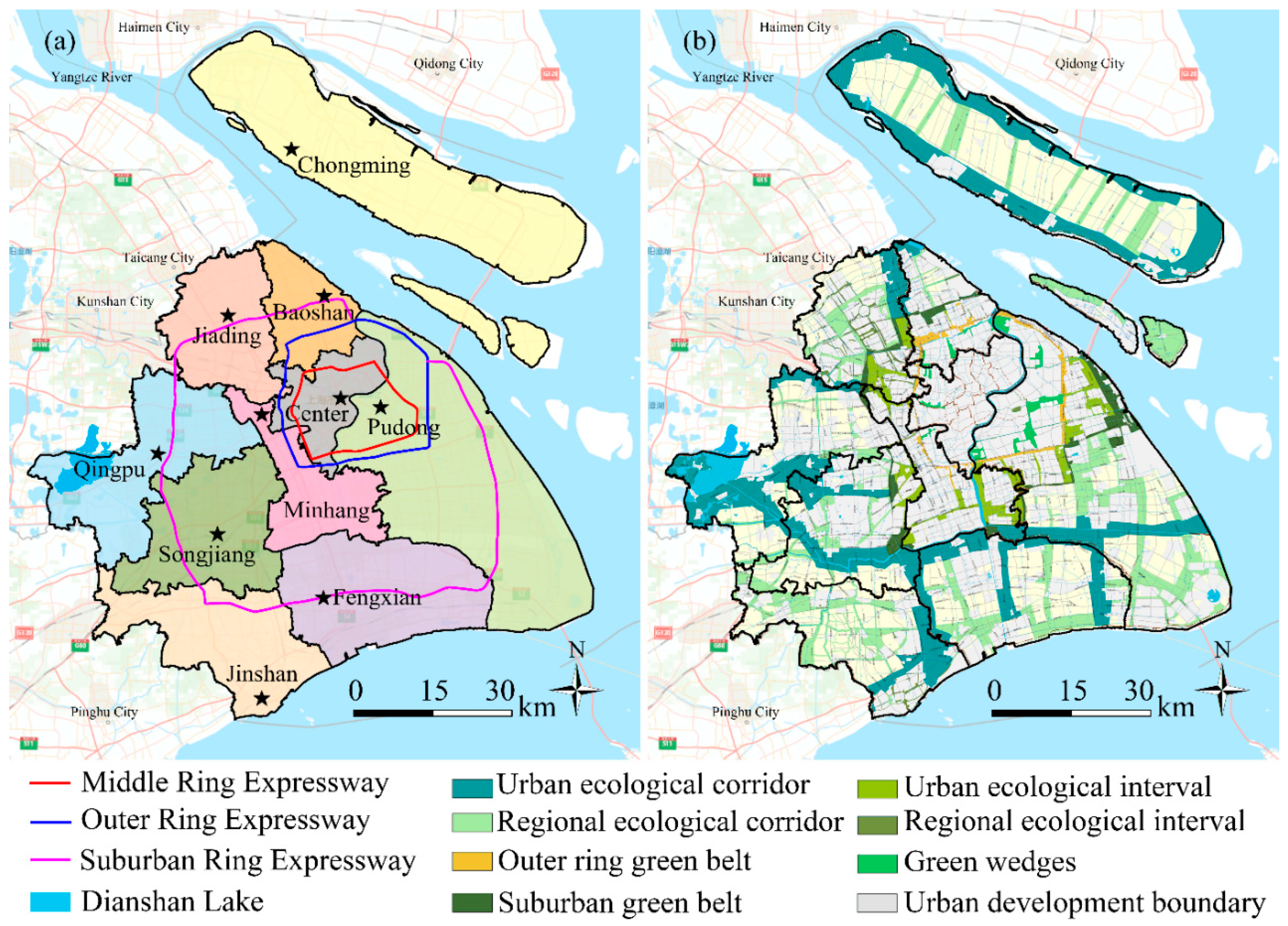
Figure 1. The study area of Shanghai: (a) The map of administrative divisions and expressways of Shanghai; and (b) Shanghai’s Ecological Network Planning Map.
Forests 12 00476 g001
Figure 2. Remote sensing-based land use patterns of Shanghai from 1990 to 2015. (a) The land use patterns in 1990; (b) The land use patterns in 1995; (c) The land use patterns in 2000; (d) The land use patterns in 2005; (e) The land use patterns in 2010; (f) The land use patterns in 2015.
Forests 12 00476 g002
Figure 3. Methodological flow chart. UGS: urban green space; DCD: dynamic change degree.
Forests 12 00476 g003
Figure 4. The eight directions and concentric belts for analyzing land-use patterns. (a) The spatial division of the eight directions; (b) the 15 concentric buffers centered at Shanghai’s city center. N: north; NE: northeast; E: east; SE: southeast; S: south; SW: southwest; W: west; NW: northwest.
Forests 12 00476 g004
Figure 5. The spatiotemporal changes of green space in the eight directions. (a) The changes of overall green space in the eight directions; (b) The changes of farmland in the eight directions; (c) The changes of forest in the eight directions; (d) The changes of grassland in the eight directions; (e) The changes of waterbody in the eight directions; (f) The changes of built-up area in the eight directions.
Forests 12 00476 g005
Figure 6. The spatiotemporal changes in the green space along the concentric buffers. (a) The changes in overall green space along the concentric buffers; (b) The changes in farmland along the concentric buffers; (c) The changes in forest along the concentric buffers; (d) The changes in grassland along the concentric buffers; (e) The changes in water body along the concentric buffers; (f) The changes in built-up area along the concentric buffers.
Forests 12 00476 g006
Figure 7. The spatial transitions from the green space and the built-up area. (a) The spatial transitions in 1990–1995; (b) The spatial transitions in 1995–2000; (c) The spatial transitions in 2000–2005; (d) The spatial transitions in 2005–2010; (e) The spatial transitions in 2010–2015; (f) The spatial transitions in 1990–2015.
Forests 12 00476 g007
Figure 8. The dynamic change degree (DCD) of the green space. (a) The DCD of overall green space; (b) The DCD of farmland; (c)The DCD of forest; (d) The DCD of grassland; (e) The DCD of water body; (f) The DCD of built-up area.
Forests 12 00476 g008
Figure 9. The landscape-level metrics of the land use pattern of Shanghai from 1990 to 2015. (a) Contagion index (CONTAG) of the land use pattern from 1990 to 2015; (b) Shannon’s evenness index (SHDI) of the land use pattern from 1990 to 2015; (c) Shannon’s evenness index (SHEI) of the land use pattern from 1990 to 2015.
Forests 12 00476 g009
Figure 10. The class-level metrics of green space and built-up area from 1990 to 2015. (a) PLAND of green space and built-up area from 1990 to 2015; (b) PD of green space and built-up area from 1990 to 2015; (c) PLAND of green space and built-up area from 1990 to 2015; (d) LSI of green space and built-up area from 1990 to 2015; (e) COHESION of green space and built-up area from 1990 to 2015.
Forests 12 00476 g010
Table 1. The land-use classification criteria applied in this study [42].
New CategoryInitial CategoryDescription
Green space
(GS)
GS1: FarmlandCroplandCultivated lands for crops, which including mature cultivated land, newly cultivated land, fallow, shifting cultivated land.
GS2: ForestWoodlandLands growing trees including arbor, shrub, bamboo and forest.
GS3: GrasslandGrasslandLands covered by the herbaceous plants with coverage greater than 5%, including shrub rangeland and mixed rangeland with the coverage of shrub canopies less than 10%.
GS4: WaterbodyWaterbodyLands covered by natural water bodies or lands with facilities for irrigation and water reservation.
Non-green spaceBuilt-up areaBuilt-up areaLands used for urban and rural settlements, factories and transportation facilities.
Unused landUnused landLands that are not put into practical use or difficult to use.
Table 2. Landscape metrics used in this study [48].
MetricsEquationsUnitJustification
Class-levelPercentage of landscape (PLAND) P L A N D = P i = j = 1 n a i j A ( 100 )
Pi = proportion of the landscape occupied by patch type (class)i.
aij = area (m2) of patchij.
A = total landscape area (m2).
PercentGeneral index
Patch density (PD) P D = n i A ( 10 , 000 ) ( 100 )
ni = number of patches in the landscape of patch type (class)i.
A = total landscape area (m2).
Number per 100 hectaresFragmentation index
Largest patch index (LPI) L P I = max j = 1 a i j A ( 100 )
aij = area (m2) of patchij.
A = total landscape area (m2).
PercentFragmentation and dominance index
Landscape shape index (LSI) L S I = 0.25 k = 1 m e i k * A
e i k * total length (m) of edge in the landscape between patch types (classes) i and k; includes the entire landscape boundary and some or all background edge segments involving classi
A = total landscape area (m2).
NoneShape index
Patch cohesion index (COHESION) C O H E S I O N = [ 1 j = 1 n p i j * j = 1 n p i j * a i j * ] [ 1 1 Z ] 1
p i j * = perimeter of patchij in terms of the number of cell surfaces.
a i j * = area of patchij in terms of the number of cells.
Z = total number of cells in the landscape.
PercentConnectivity index
Landscape-levelContagion index (CONTAG) C O N T A G = [ 1 + i = 1 m k = 1 m [ p i g i k k = 1 m g i k ] [ ln ( p i g i k k = 1 m g i k ) ] 2 ln ( m ) ] ( 100 )
Pi = proportion of the landscape occupied by patch type (class)i.
gik = number of adjacencies (joins) between pixels of patch types (classes) i and k based on the double-count method.
m = number of patch types (classes) present in the landscape, including the landscape border if present.
PercentConnectivity and fragmentation index
Shannon’s diversity index (SHDI) S H D I = i = 1 m ( p i * ln p i )
Pi = proportion of the landscape occupied by patch type (class)i.
NoneDiversity index
Shannon’s evenness index (SHEI) S H E I = i = 1 m ( p i * ln p i ) ln m
Pi = proportion of the landscape occupied by patch type (class)i.
m = the number of patch types (classes) present in the landscape, excluding the landscape border if present.
NoneDiversity index
Table 3. The overall changes in urban green space (UGS) of Shanghai in 1990–2015.
Land-Use Type199019952000200520102015
GS1: FarmlandArea (km²)4964.9 4627.4 4548.9 4218.8 3753.1 3686.7
Percent (%)71.3 66.5 65.3 60.653.9 52.9
GS2: ForestArea (km²)105.4 105.3 103.0 110.8 101.1 96.8
Percent (%)1.5 1.5 1.5 1.61.5 1.4
GS3: GrasslandArea (km²)44.9 41.4 41.9 48.7 79.8 92.5
Percent (%)0.6 0.6 0.6 0.7 1.1 1.3
GS4: WaterArea (km²)788.1 802.8 804.2 727.7 689.6 437.4
Percent (%)11.3 11.5 11.5 10.4 9.9 6.3
GS: Total green spaceArea (km²)5903.3 5576.9 5498.1 5105.9 4623.5 4313.4
Percent (%)84.8 80.1 79.0 73.3 66.4 61.9
Non-green spaceArea (km²)1060.2 1386.7 1465.5 1857.6 2340.1 2650.2
Percent (%)15.2 19.9 21.0 26.7 33.6 38.1
Table 4. The land-use transition matrixes between 1990 and 2015.
YearCategory1995
Farmland (km²)Forest (km²)Grassland (km²)Waterbody (km²)Built-Up Area (km²)
1990Farmland (km²)4621.0 0.6 0.0 16.6 326.7
Forest (km²)0.4 104.5 0.0 0.2 0.3
Grassland (km²)0.1 0.0 41.4 0.0 3.5
Waterbody (km²)1.1 0.1 0.0 785.9 1.0
Built-up area (km²)4.9 0.1 0.0 0.1 1037.5
2000
1995Farmland (km²)4536.4 0.4 0.0 5.7 85.0
Forest (km²)0.4 102.4 0.0 0.2 2.3
Grassland (km²)0.0 0.0 41.3 0.1 0.0
Waterbody (km²)2.6 0.1 0.6 798.0 1.5
Built-up area (km²)9.5 0.1 0.0 0.2 1359.1
2005
2000Farmland (km²)4127.0 11.5 0.1 19.8 390.6
Forest (km²)1.5 96.0 0.0 0.6 4.9
Grassland (km²)0.7 2.0 39.1 0.2 0.1
Waterbody (km²)65.0 0.6 9.5 706.7 22.4
Built-up area (km²)24.7 0.7 0.0 0.5 1421.9
2010
2005Farmland (km²)3731.2 1.7 0.1 4.9 481.0
Forest (km²)1.1 98.6 0.0 0.1 11.0
Grassland (km²)0.1 0.0 48.4 0.1 0.1
Waterbody (km²)3.4 0.4 0.1 714.8 9.0
Built-up area (km²)17.4 0.4 0.0 0.8 1821.2
2015
2010Farmland (km²)3468.4 2.6 5.4 13.6 263.0
Forest (km²)2.9 92.3 0.0 0.6 5.2
Grassland (km²)3.8 0.0 43.5 0.3 1.0
Waterbody (km²)133.2 0.8 31.2 417.1 26.9
Built-up area (km²)63.6 1.0 12.4 3.1 2242.3
2015
1990Farmland (km²)3473.2 7.8 13.1 42.5 1428.3
Forest (km²)2.7 85.4 0.0 1.0 16.2
Grassland (km²)4.3 1.9 33.8 0.3 4.6
Waterbody (km²)171.5 1.2 41.3 389.5 73.0
Built-up area (km²)20.1 0.5 4.4 1.3 1016.3
Publisher’s Note: MDPI stays neutral with regard to jurisdictional claims in published maps and institutional affiliations.