Article

Early Monitoring of Health Status of Plantation-Grown Eucalyptus pellita at Large Spatial Scale via Visible Spectrum Imaging of Canopy Foliage Using Unmanned Aerial Vehicles

by
Megat Najib Megat Mohamed Nazir
1,2,
Razak Terhem
2,3,*,
Ahmad R. Norhisham
2,4,
Sheriza Mohd Razali
2 and
Roger Meder
5,6
1
Tree Plantation Division, Sabah Softwoods Berhad, Tawau 91019, Sabah, Malaysia
2
Institute Tropical Forestry and Products (INTROP), Universiti Putra Malaysia, Serdang 43400, Selangor, Malaysia
3
Laboratory of Forest Pathology and Tree Health, Faculty of Forestry and Environment, Universiti Putra Malaysia, Serdang 43400, Selangor, Malaysia
4
Department of Forestry Science and Biodiversity, Faculty of Forestry and Environment, Universiti Putra Malaysia, Serdang 43400, Selangor, Malaysia
5
Forest Industries Research Centre, University of the Sunshine Coast, Sippy Downs, QLD 4556, Australia
6
Meder Consulting, Bracken Ridge, QLD 4017, Australia
*
Author to whom correspondence should be addressed.
Forests 2021, 12(10), 1393; https://doi.org/10.3390/f12101393
Submission received: 8 July 2021 / Revised: 6 September 2021 / Accepted: 16 September 2021 / Published: 13 October 2021
(This article belongs to the Special Issue Remote Sensing Applications in Forests Inventory and Management)

Abstract

:
Eucalyptus is a diverse genus from which several species are often deployed for commercial industrial tree plantation due to their desirable wood properties for utilization in both solid wood and fiber products, as well as their growth and productivity in many environments. In this study, a method for monitoring the health status of a 22.78 ha Eucalyptus pellita plantation stand was developed using the red-green-blue channels captured using an unmanned aerial vehicle. The ortho-image was generated, and visual atmospheric resistance index (VARI) indices were developed. Herein, four classification levels of pest and disease were generated using the VARI-green algorithm. The range of normalized VARI-green indices was between −2.0 and 2.0. The results identified seven dead trees (VARI-green index −2 to 0), five trees that were severely infected (VARI-green index 0 to 0.05), 967 trees that were mildly infected (VARI-green index 0.06 to 0.16), and 10,090 trees that were considered healthy (VARI-green index 0.17 to 2.00). The VARI-green indices were verified by manual ground-truthing and by comparison with normalized difference vegetation index which showed a mean correlation of 0.73. This study has shown practical application of aerial survey of a large-scale operational area of industrial tree plantation via low-cost UAV and RGB camera, to analyze VARI-green images in the detection of pest and disease.

1. Introduction

Plantations of genus Eucalyptus L’Hér now amount to more than 20 million hectares globally [1] and are the second largest global forest plantation species behind Pinus L. [2]. Their capability for fast growth, ability to grow in a range of site conditions, ease of propagation, and their desirable wood qualities have led to widespread establishment of large Eucalyptus plantations in many countries of Southeast Asia which has over 2.5 million planted ha [3]. The wood of Eucalyptus is suitable for use in a variety of products, such as sawn timber, pulp, paper, civil construction, furniture and energy production purposes, and veneer or plywood production. In the Malaysian state of Sabah on Borneo Island, Eucalyptus species and hybrids have been shown to have high productivity and have a variety of end use potentials [4,5,6,7]. As countries increasingly restrict the access to natural forests for log supply, there are estimates that 50% of the world’s hardwood harvest could come from Eucalyptus plantations by 2030 [8]. In the Malaysian states of Sarawak and Sabah, industrial tree plantations are predominantly planted with Eucalyptus pellita F. Muell. or eucalypt hybrids. The prevalence of eucalypts in recent years is the result of a major outbreak of Ceratocystis among the previously dominant species, Acacia mangium Willd., resulting in a high rate of mortality [9,10,11,12]. The risk of pest and disease remains constant and it is therefore essential to monitor plantations to detect any potential incidence of disease. Any pest and disease outbreak in Eucalypt plantations has the potential to endanger the Malaysian forest industry, which aims to produce 75 million m3 of timber per annum to meet the raw material requirement of the Malaysian timber industry, which in the past 10 years has exported more than RM100 billion (USD24.4 billion) of wood products or 17% of Malaysia’s total export [13].
To monitor for potential outbreak of pest and disease in E. pellita plantations, field surveys are important for pest and disease detection, however they are labor-intensive, time-consuming, and are not practical in areas with particularly steep terrain. Instead, precision agriculture techniques using high resolution remote sensing from unmanned aerial vehicles (UAV) with a variety of different sensors, or even conventional red-green-blue (RGB) cameras, would lead to cheaper and more practical monitoring of forest health [14,15,16,17]. Furthermore, rapid development of hardware and software, and improvement in the miniaturization of the sensors have led to the widespread use of UAV for obtaining higher temporal and spatial resolution [18,19,20]. It is now possible for UAVs to fly in excess of 20 h [21] and to cover more than 200 ha per flight [18]. This is sufficient to address the needs of most forest plantation operations which require collecting data in a shorter time, with fewer personnel and with minimal impact on the field. The use of UAV together with big data analytics and artificial intelligence provides new approaches for plant phenotyping [20,22,23,24,25] determination of plant height (growth) [26,27] to evaluate plant varieties [28] and detection of pest [29]) and disease [30,31].
Several vegetation indices (VI) have been developed for remotely sensed images. They mostly cover the visible region of the spectrum (red, green, blue, the so-called RGB channels) or shortwave near-infrared (SWNIR), although the SWNIR region is ill-defined, but is commonly accepted to range from approximately 800 nm (red-edge) to 2500 nm. Given the high cost of true NIR spectral cameras that are capable of operating above ~1300 nm, most vegetation indices are actually confined to the visible and red-edge (up to around 1200 nm). One important consideration for remote sensing with UAVs is the payload weight, and this, combined with cost, further reduces the potential camera systems to simple RGB cameras. For RGB images, the visual atmospheric resistance index (VARI) green index [32] can benefit from normalized difference vegetation index (NDVI) using the ERTS-1 satellite (later Landsat-1) multispectral scanner [33,34].
Remotely sensed data have been used for plant phenotyping, including indices to assess plant health status [16,17,18,30,35,36,37,38]. The authors of [30] claimed that the use of UAV RGB imagery is more effective for estimation of disease resistance of potato light blight compared to visual assessments. Most recently, VARI-green provided reliable information to monitor tree health in Eucalyptus pellita in Indonesia [39]. Despite the potential advantages of UAV to collect high-resolution imagery, its application to detect biotic damage in forest plantation are currently rare in the literature. In this study, pest and disease symptoms in a stand of E. pellita were demonstrated using a similarly low-cost consumer UAV equipped with a similarly low-cost consumer RGB camera. This was an intentional decision to explore the capability of a readily available and affordable system without the need for expensive or sophisticated equipment such as hyperspectral/multispectral cameras. The aim of the study were to (1) investigate the health status of 1–2-year-old Eucalyptus pellita in a commercial plantation using VARI-green, (2) ground-truth the VARI-green result with proximally sensed NDVI data visual inspection, and (3) develop a range of indices of VARI-green as benchmark for detection and monitoring of health status.

2. Methods

2.1. Study Area and Tree Health Data

This study was undertaken in the industrial tree plantation of Brumas estate at Sabah Softwoods Berhad (Tawau, Sabah, located at latitude 4°35′36″ N and longitude 117°45′31″ E between 200 and 600 m elevation above sea level in the southern regionof the Malaysian state of Sabah on the island of Borneo (Figure 1). The total planted area at SSB is approximately 18,000 hectares, which is predominantly E. pellita (60%) and Falcataria moluccana Barneby & Grimes (formerly Albizia falcataria L. Fosberg) as a secondary species (25%), along with Eucalyptus hybrids (5%) and conservation plantings (10%). The soil is dominated by Tanjung Lipat soil type with clay texture between 25% to 35% and Kumansi type with >40% clay content [40]. Block 42H, a commercial planting of E. pellita and selected for this study, was planted in May 2018, with an area of 22.78 ha at a spacing of 3 m × 3 m (1111 stems per hectare, sph). A younger commercial planting (six-month-old E.pellita) was also assessed in Block 42G. In this block, a total of 4399 trees were planted in an area of 7.56 ha.

2.2. Early Inventory Measurement

The early inventory measurement (EIM) was completed five months after planting, while the ground-truth verification was completed after completion of the flight used for the VARI-green analysis.
In the EIM, visual inspection of E. pellita health was conducted at all study sites to establish ground reference dataset. Tree health inspection was undertaken by an experienced assessor who was trained and actively engaged in pest and disease survey in Sabah Softwood plantations.
The block 42H was chosen because of the young age when assessed using an unmanned aerial vehicle in November 2019 (1 year 7 months [19 months]), and the early inventory measurement (EIM) on the block which showed a variety of tree health status from virulent to dead.

2.3. Unmanned Aerial Vehicle Image Acquisition

High-resolution aerial images were acquired using an unmanned aerial vehicle (UAV) namely a Phantom 4 Pro, (Shenzen DJI Sciences and Technologies (DJI), Shenzhen, China, Figure 2) equipped with a readily available consumer market RGB camera (Go-Pro 5, San Mateo, CA, USA) with a payload weight of 500 g. This configuration of UAV was used to obtain high spatial resolution imagery in the visible spectrum. The aerial survey work was undertaken on 27 November 2019, with an altitude above canopy of 129 m and overlapping image swathes of 60% (forward) and 30% (side). Map Pilot for DJI software (Drones Made Easy, San Diego, CA, USA) was used to set the parameters (Table 1) for flightpath planning and control the movement and speed of the UAV. The constant ground sample distance (GSD) mode was set during the flight. A total of 178 images were obtained. The ground truth (GT) covered 24 plots (radius of 11.5 m) randomly scattered in the block which represents 4.22% of the total area (22.87 ha).
Ground truth assessments were conducted to classify infestation levels on E. pellita caused by pests and diseases. Tree health status was based on the following conditions: healthy (no sign of infestation on foliage and stem), moderate (distortion in foliage and shoots dieback), severe (splitting of stem with distortion and/or discoloration in foliage), and dead (trees no longer functional with discoloration of vascular tissues and wilting of foliage). These severity levels were used to demonstrate the potential of RGB remote images to distinguish health status of individual trees.

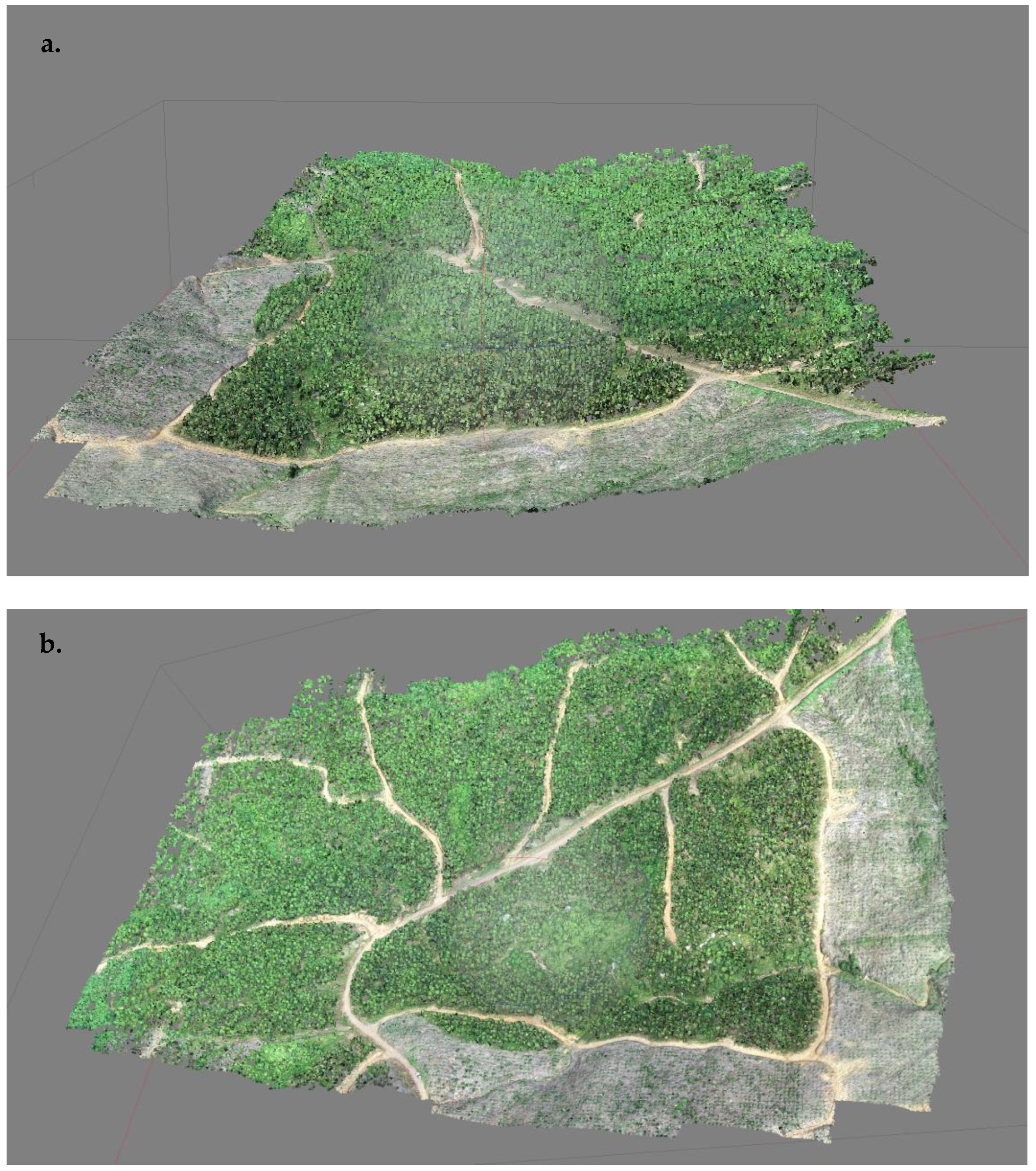
2.4. Image Processing

Images were processing using Agisoft Metashape software (Agisoft, St Petersburg, Russia) to generate ortho-images using parameters shown in Table 2, which is this similar to the parameters used by Del-Campo-Sanchez et al. [18]. Three key steps were used to process the UAV images: initial processing, point cloud densification, and ortho-image generation. For initial processing, an automatic aerial triangulation (AAT) algorithm was used to refine the exterior orientation for all images (N = 178) in order to compute direct georeferencing for each image. Then, bundle block adjustment (BBA) was automatically performed to utilize the measured distance between points in order to generate an adjusted relative three-dimensional (3D) coordinate system. For point cloud densification (Figure 3), the X, Y, Z position and the color information were computed based on the automatic tie points (ATP) in the initial processing stage. In ortho-image generation, digital surface models (DSM) with resolution 0.135 m were generated and used as reference for ortho-mosaic image creation. Agisoft software was used to import a third-party surface model for ortho-image generation, light detection and ranging (LIDAR), or interferometry synthetic aperture radar (IFSAR).
The geomatic information obtained by GSD photogrammetric techniques is in this study a minimum of 3.5 cm pixel−1. The tie points for the cloud characteristics are summarized in Table 3. The setting during the flight plan met the geomatic proposed desirable quality of final ortho-mosaic product. The ortho-images covered 27.22 hectares and provided information at a resolution of 3.5 cm GSD. The volume of data obtained from this setting were summarized in Table 4.

2.5. Image Analysis

Image analysis was performed using ArcGIS version 10.1 (Esri, Redlands, CA, USA). The UAV images were converted into vector shapefiles (.shp), after which, point location of the trees was plotted and buffered at a 1.0 m radius using the editor and multiple ring buffer tools. Forest blocks, roads, and stream features in the study area were digitized to represent the complete land cover map of Block 42H. The digitized tree was buffered to 1.0 m radius as an estimation of the Eucalyptus trees crown diameter affected by disease or mortality. The estimation is based on the maximum healthy tree crown diameter in Block 42H. The buffering layer were then overlaid and clipped on the VARI-green image using Extract tools. The VARI-green index is a vegetation index produced entirely in the visible region of the spectrum using the three visible channels of red (R, 564–580 nm), green (G, 534–545 nm), and blue (B, 420–440 nm) using the algorithm of [32] ((G − R)/(G + R − B)). The index generates a greenness level, from which tree health can be determined. The higher the index level, the healthy the trees.
The processed image bands were separated into single bands of R, G, and B using “make a raster layer” in management tools. Then, the single band inserted in raster calculator using syntax dialog. The VARI-green index was computed using Spatial Analyst of Raster calculator tool then, the value was normalized with an absolute value 10 (ABX) and log was set to Log10. After the soil threshold was determined, the VARI-green image was clipped using Data Analysis tools to isolate the individual trees from soil feature. Total digital value in the VARI-green image was normalized using ABX and LOG formula. Log 10 was used to raise the digital number. The range between −2 and 2 represents the damage severity levels for infected trees (light green) to healthy trees (deep green).

2.6. Zonal Statistics

Once separation between trees and soil on the VARI-green raster image is completed, the calculations of digital number were made to identify the healthy and unhealthy trees. The Zonal Statistic tools in ArcGIS 10.1 were used to calculate the digital number on the VARI-green image. With zonal statistic tools, all digital numbers on the VARI-green were calculated based on each zone dataset. A single output value is computed for every zone in the input dataset. The statistic input was recorded using Excel files for every tree on the VARI-green raster image. The digital values from the VARI-green raster ranged from −101 to 96.

2.7. Normalized Difference Vegetation Index (NDVI)

A GreenSeeker handheld crop sensor (Trimble Inc., Sunnyvale, CA, USA) was used to measure the Normalized Difference Vegetation Index (NDVI) for each tree located in the three selected plots 1, 17, and 24. These plots were chosen because of the highest number of dead trees were recorded during the EIM.

2.8. Confusion Matrix and Kappa Coefficient

In this study, classification of tree health class was developed based on unsupervised classification available in ArcGIS software. After that, confusion matrix and kappa coefficient were derived for classification. Kappa used to calculate proposed classification method performance, which higher kappa value approaching +1.0 showed strong correlation between classification and validation or reference class data. Furthermore, note that Kappa is not a measure of accuracy but of agreement beyond chance, and thus chance correction is not needed [41].
The confusion matrix was created based on the individual class accuracy that was calculated by dividing the element for each class (row and column). Next, the Producers Accuracy can be generated by dividing each of the major diagonal class with total number of elements on the column of category. The User Accuracy was computed by dividing each of the major diagonal with total number of rows of the element that was classified. Then, the value of kappa coefficient can be generated by using equations below, were the nearest the kappa value to 1, represent the perfect agreement [42].

3. Results

3.1. Tree Health Data and VARI-Green Indices

In Block 42H (aged 1 year 7 months [19 months] old ), a total of 11,069 E. pellita trees were recorded and assigned to one of the four classifications of tree health Table 5 based on infestation levels. Seven trees were classified as dead (VARI-green index −2 to 0), five trees were severely infected (VARI-green index 0 to 0.05), 967 trees were mildly infected (VARI-green index 0.06 to 0.16), and 10,090 trees were considered healthy (VARI-green index 0.17 to 2.00). The individual overall tree health status shown in the map of Block 42H in (Figure 4).
The VARI-green analysis undertaken in the 6-month-old stand (Block 42G) was, however, unsuccessful due to the size of the tree crowns being too small for detection.
Results of 24 plots assessed in Block 42H during early inventory monitoring, ground-truthing, and after VARI-green analysis are given in Figure 5. In total, 1065 trees were recorded as living during the EIM, and 754 trees were recorded as living after VARI-green analysis. In total, 25 trees were recorded dead during the EIM and one was recorded dead after VARI-green analysis. In total, 23 trees were recorded as missing during the EIM, while 255 trees were recorded missing after VARI-green analysis. The summary ground-truth results Table 6, verified one tree as dead (Class 1) and one tree as severely infected (Class 2), respectively, while 58 trees were recorded as being mildly infected (Class 3) and 686 trees were recorded as healthy (Class 4).
The NDVI data (Supplementary Tables S1–S3) were collected to further validate the VARI-green indices data. The resulting correlation between NDVI and VARI-green showed slight differences by plot with a mean correlation value for the three trial plots of ~0.73. The highest correlation value was observed in Plot 17 followed by Plot 24 and Plot 1 with values of 0.78, 0.72, and 0.69 respectively.
To assess the accuracy classification of tree health, we adopted a confusion matrix of the classification and kappa coefficient. The confusion matrix in Table 7 shows model prediction for each class are approximately between 60% to 100%, however class II of severe class showed very low accuracy with 0.02%. For this matrix, producer’s accuracy was between 71% and 100%, meanwhile user’s accuracies were between 0.0% and 98%. The overall accuracy of 0.91 succeeded in identifying almost all tree health categories with more than 90% accuracy.

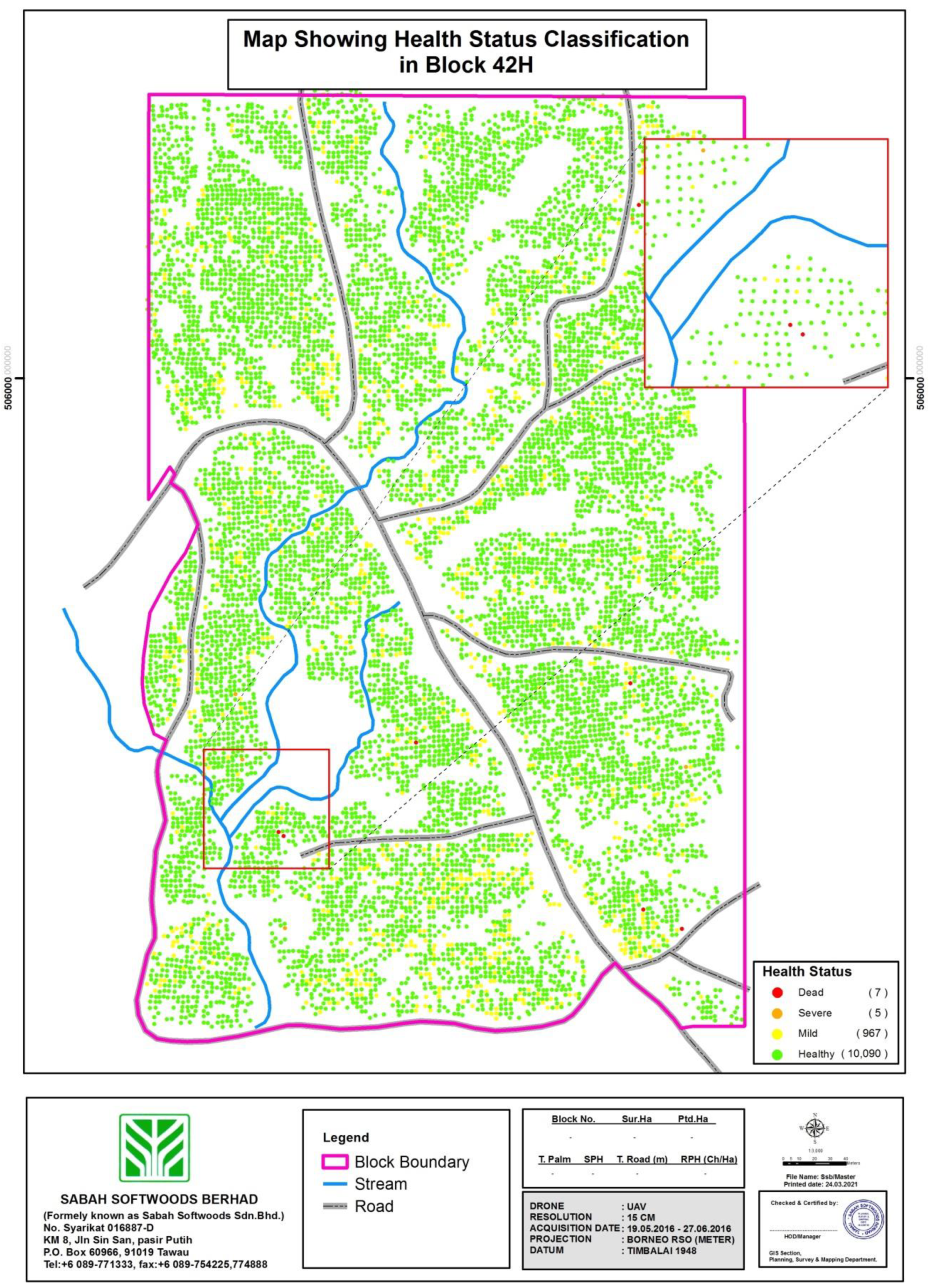
3.2. Range of Index Map of VARI-Green as Benchmark for Detection of Health Status Using UAV

In this study, four classifications of health status were developed as a benchmark for detection of individual tree health (Figure 6). Classification was based on the percentage of red within the VARI-green result for each individual tree. The resulting VARI-green index values were assigned to one of the four health classes.
Figure 7 shows the procedure to generate VARI-green plots from the raw data. Ortho-mosaic rasters (Figure 7a) from RGB processed data clearly show the normal visualization of selected plot, from which the VARI-green raster is calculated (Section 2.5). The VARI-green raster (Figure 7b) is a result that shows the selected plot via hyperspectral visualization. To ease analysis, the tree data were isolated from soil to produce the tree-based VARI-green (Figure 7c). Due to the crowded indices data, normalized VARI-green output (Figure 7d) is produced to normalize the data between two classifications of indices, namely, 2 to 0 and 0 to −2. From these data, the classification of tree health status was created, based on the percentage of red in the VARI-green tree crown (Figure 8).

3.3. VARI-Green Pattern and Tree Health Status

The VARI-green classification map quantifies the amount of greenness in an image and differentiates between infestation levels of individual trees based on the relative amount of red in the green image. Dead trees (Class 1) appeared in the VARI-green raster pattern as totally red (Figure 8a), while severe infection (Class 2), caused in this instance by stem borer, was represented by VARI-green raster signatures with up to 80% red at the center of trees encircled by green (Class 2: Figure 8b). For mild infection (Class 3), trees show distortion in foliage and shoot dieback with VARI-green showing scattered red on individual trees (Class 3: Figure 8c). Healthy trees (Class 4) show no sign of infection on foliage and stems. The VARI-green raster pattern for Class 4 shows complete, or nearly complete, green or individual trees (Class 4: Figure 8d). Based on this variation in VARI-green pattern, the majority of trees in Block 42H are almost in perfect condition or healthy.

4. Discussion

The results of VARI (Visual Atmospheric Resistance Index) image analysis using the green channel suggest that UAV equipped with RGB cameras can be used to monitor plant health status in plantation forests. In this study, the effectiveness of a UAV equipped with a RGB camera was trialed in a young (19-month-old) stand of plantation-grown Eucalyptus pellita in the wet tropics in Sabah, Borneo, Malaysia. Without the need for more expensive hyperspectral cameras, simple RGB images processed using the VARI-green algorithm were able to assess pest and disease early in the growth stage. The result of this study has shown that the infestation and infection of unhealthy E. pellita in industrial tree plantation could be detected with the VARI-green images obtained from a low-cost drone with a low-cost RGB camera across a large area (22.78 ha). This is because VARI-green has been found to be less sensitive to atmospheric effects than NDVI, allowing a good estimation of vegetation fractions as found by [32,39].
Considering the typical host specificity of pest and disease of E. pellita, the classification of VARI-green images can be categorized into four classes. This classification was based on the interpretation with VARI-green index of ortho-mosaic images and ground truth verification. Confusion matrix was developed to calculate misclassification or error classification according to [43]. The result showed that our proposed methods achieve satisfactory performance, with a kappa coefficient of 0.62 and overall accuracy of 91% [44]. However, this study lacks molecular identification, while ground verification of plant health status classes is based on typical symptoms shown by the pathogen and the presence of insect pests. In the case of the dead, Class 1 E. pellita, the main cause of mortality was the soilborne pathogen, Ralstonia solanacearum. During ground inspection, dead trees exhibited leaf drop for entire the crown, branch dieback, and reduced growth. Ralstonia has been reported as a destructive phytopathogen that infects the xylem tissue leading to tree death [2,45] and has been reported to cause mortality in young E. pellita in Indonesia [39].
Based on ground verification, Class 2 was mainly caused by stem borers Zeuzera coffeae (Cossidae) and Endoclita sp. (Hepialidae) with trees showing symptoms of splitting stems and stunted growth. Attack by stem borer has been reported to interrupt nutrient transportation due to swollen stems that cause breaking of the crown top resulting in poor wood quality [46]. For Class 3, trees were infected by mirid bugs, Helopeltis sp. (Miridae). Helopeltis predominantly attack young Eucalypt leaves and shoots causing lesions, curling and drying of the foliage [47]. In addition to pest infestations, tree plantations may also suffer from water stress that causes leaf shedding however most trees retained younger leaves to cope with water deficit [48].
Overall, the early inventory monitoring results show 4% of seedling death and missing trees within the sample plots (0.96 ha) at 3 months post planting. The VARI-green data obtained 19-months post planting show 34% of seedlings as dead or missing in the sample plots (0.96 ha) from VARI-green analysis of RGB images. As a newly planted block, the trees in Block 42H are vulnerable due to their small size. They face hazards such as hot, dry weather, insect infestation, browsing by larger animals [49] or competition from vigorous weed growth although site preparation requires weed-free establishment according to Sabah Softwoods’ standard operating procedure [50]. Despite this, it is accepted as normal in plantation forestry that 5–10% of the seedlings may die from one or other of these causes within the first year [49]. As shown in the results (Table 6), the high number of missing trees after VARI-green analysis compared to EIM is up to 30% may influence by several factor. The VARI-green analysis was performed 19 months post planting compared to the EIM assessment at 3 months post planting. Within this period, numerous changes have occurred in terms of tree mortality, due to any one of several biotic and/or abiotic events, e.g., drought and hot weather and infestation of pest and disease. The difference in assessment of dead and missing trees between the VARI-green result and the EIM assessment may be due to errors in either or both survey methods. The RGB images acquired by UAV may suffer from parallax error that occurs due to changes in the relative position of the object or the observation point, whereas double counting or missing counting during the manual early inventory measurement may result in discrepancies. In this study, the VARI-green analysis and ground-truth verification in three plots were able to reduce the counting error with respect to the EIM. These results agree with those of [30] whereby the use of UAV RGB imagery is more effective for estimation of tree heath compared to visual assessments.
From a viewpoint of managing the plantation forest, VARI-green analysis indicates that only 0.06% of trees were dead and 0.04% of tree we severely infected, while 9% of the trees showed mild inhibition and 90% the trees were healthy in the total area of 22.78 ha. In terms of overall survey area, this study is amongst the largest undertaken for the detection of pest and disease in any crop: [31] covered 0.19 ha of potato crop, [39] assessed 3 ha of E. pellita, [30] 0.14 ha of potato crop, and [18] 5.03 ha of vineyard. The development of a health indices map combined with the practical survey of large areas shows the novelty of the study. The health indices map is easy to use, allowing plantation forest managers to view the health status of commercial forests block using comparatively low-cost technology in a rapid manner. Use of UAV to survey forest health would enable considerably larger areas to be assessed (23 ha in 30 min) compared to ground crews (10 ha per day). Aerial surveys of tree health would allow decision-making on operational procedures such as treatment of the infected area or replanting of missing trees.
Detection of early plant stress [51]; nutrient status [52]; and plant phenotyping including height, flower, and canopy cover [53] use NDVI for mapping vegetation condition and status [54]. However, NDVI requires a multispectral sensor operating in the red-edge near-infrared (NIR) wavelength range [16,17]. Near infrared cameras are more expensive than RGB cameras and require time-consuming calibration procedures [54] unlike VARI-green. VARI-green is based simply on RGB images [18] and can operate at very high resolution using low-cost UAV. This study developed plant health indices using a GoPro consumer RGB camera which was considerably cheaper than a UAV equipped with a hyperspectral camera. Though the reliability and simplicity of VARI-green has earned its popular use [54], other plant indices have been developed using conventional RGB camera. Ref. [32] found VARI-green to be minimally sensitive to atmospheric effects allowing estimation of vegetation fraction with an error of <10% in a wide range of atmospheric optical densities. This study has verified the remotely sensed VARI-green indices with proximal NDVI measures, which have shown acceptable agreement.
The total flight time of 30 min used in this study was shown to be sufficient to cover the survey area of around 23 hectares. Due to the short duration of the flight and the ease of development of plant health indices for E. pellita, it is proposed that UAVs with simple RGB cameras have the potential and cost effectiveness to operate in large-scale monitoring of plant health not only in Malaysia, but also within the tropical countries where E. pellita is grown. The study provides a methodology to assess infection on the ground with aid of remote sensing UAV image for minimal cost. It is an innovative technique that can be included in plantation management plans, not only for tree plantations, but it may also be suitable for other plantation crops such as oil palm. It is not intended that this method be a total replacement of conventional ground verification or conventional surveying methods. Instead, it is intended that aerial survey provide complementary data to rapidly and safely distinguish unhealthy areas of plantation with minimal labor cost. This would allow growers to quickly target affected areas which would be ground-truthed by trained field crews who could back-up the identification of the disease outbreak using molecular identification and morphology identification. The relationship between VARI-green and ground survey showed good agreement providing a reliable classification tool for plantation managers. The four classes of plant health status have been selected for the management to provide extra information regarding the tree’s health enabling better decision-making to control pest and disease outbreaks.
While this study was proven to be reliable for E. pellita at a stand age of 19 months, younger trees failed to be detected by the VARI-green algorithm due to the small crown size. In a forest block of 6-month-old E. pellita (Block 42G), VARI-green analysis was unable to differentiate between trees, indicating that there must be a minimum canopy size before VARI-green can produce reliable result. These findings also suggest that forest plantation deployed with species such as Albizia sp. and Tectona grandis may encounter similar problems of confounding values in VARI-green analysis due to overlapping crown.

5. Conclusions

There are competing needs for speed and ease of monitoring large areas of planted forest and the need for accuracy and precision. In a practical operation for a forest grower managing tens of thousands of hectares of planted forest, aerial survey of forest health using VARI-green from RGB imaging, is a qualitative assessment that is provides information across a large area at the expense of lower accuracy. It is the relative area that is affected which is important. To determine whether 30% of an area is potentially affected does not require a high degree of accuracy: it is simply enough to know that between 25% and 35% is affected, or less than 10% or more than 50%, etc. The commercial leverage achieved by using UAV remote sensing systems to assess tree health is the ability to survey large areas in a short period of time, and even more powerfully the ability to survey remote and steep terrain safely, without the need for ground crews to be present. This study has shown that significant plantation areas (in this instance 22.78 ha.) can be surveyed in half a day.

Supplementary Materials

The following are available online at https://www.mdpi.com/article/10.3390/f12101393/s1, Table S1: NDVI value for each tree in Plot 1, Supplementary Table S2: NDVI value for each tree in Plot 17 and Supplementary Table S3: NDVI value for each tree in Plot 24.

Author Contributions

M.N.M.M.N., Conceptualization, Methodology, Investigation, Formal analysis, Writing, Visualization; R.T., Conceptualization, Supervision, Methodology, Writing, Funding acquisition, Review and editing; A.R.N., Supervision, Review and editing; S.M.R., Supervision, Methodology, Review and editing; R.M., Supervision, Conceptualization, Methodology, Review & editing. All authors have read and agreed to the published version of the manuscript.

Funding

This work was supported by the key program of Transdisciplinary Research Grant Scheme (TRGS 2018-1), Reference code: TRGS/1/2018/UPM/01/2/1 Ministry of Higher Education Malaysia.

Data Availability Statement

Not applicable.

Acknowledgments

Special thanks to Hardrie bin Jadil for EIM data collection and Rahim Bin Nordin as a drone pilot for this project. The study was conducted as part of the Borneo Forestry Cooperative’s forest health programme, and particular support from Sabah Softwoods Bhd, for Megat Najib Megat Mohamed Nazir and for allowing access to Block 42 H and 42 G is gratefully acknowledged.

Conflicts of Interest

The authors declare no conflict of interest.

References

  1. Laclau, J.P.; Mareschal, L.; Bouvet, J.M. Eucalyptus plantations. Editorial. For. Ecol. Manag. 2020, 474, 3. [Google Scholar]
  2. Old, K.M.; Wingfield, M.J.; Yuan, Z.Q. A manual of Diseases of Eucalyptus in South-East Asia. CIFOR 2003. [Google Scholar] [CrossRef] [Green Version]
  3. Dell, B.; Hardy, G.; Burgess, T. Health and nutrition of plantation eucalypts in Asia. South. For. 2009, 131–138. [Google Scholar] [CrossRef] [Green Version]
  4. Hii, S.Y.; Ha, K.S.; Ngui, M.L.; Penguang, S., Jr.; Duju, A.; Xy, T.; Meder, R. Assessment of plantation-grown Eucalyptus pellita in Borneo, Malaysia for solid wood utilisation. Austr. For. 2017, 80, 26–33. [Google Scholar] [CrossRef]
  5. Jarapudin, Y.; Lapammu, M.; Alwi, A.; Warburton, P.; Macdonell, P.; Boden, D.; Brawner, J.T.; Brown, M.; Meder, R. Growth performance of selected taxa as candidate species for productive tree plantations in Borneo. Austr. For. 2020, 83, 29–38. [Google Scholar] [CrossRef]
  6. Jarapudin, Y.; Meder, R.; Chiu, K.C.; Lapammu, M.; Alwi, A.; Ghaffariyan, M.; Brown, M. Veneering and sawing performance of plantation-grown Eucalyptus pellita, aged 7-23 years, in Borneo Malaysia. Int. Wood Prod. J. 2021, 12, 116–127. [Google Scholar] [CrossRef]
  7. Jarapudin, Y.; Meder, R.; Lapammu, M.; Alwi, A.; Ghaffariyan, M.; Brown, M. Mechanical wood properties of plantation-grown E. pellita in Borneo Malaysia. Evidence of suitable properties for high-value timber end-use. Int. Wood Prod. J. 2021, 72. [Google Scholar] [CrossRef]
  8. RISI. Eucalypt Sawlog Market Outlook. 2016. Available online: https://www.risiinfo.com/product/eucalyptus-sawlog-outlook/ (accessed on 26 April 2021).
  9. Roux, J.; Wingfield, M.J. Ceratocystis species: Emerging pathogens of non-native plantation Eucalyptus and Acacia species. South. For. 2009, 71, 115–120. [Google Scholar] [CrossRef]
  10. Tarigan, M.; Van, W.M.; Roux, J.; Tjahjono, B.; Wingfield, M.J. Three new Ceratocystis spp. in the Ceratocystis moniliformis complex from wounds on Acacia mangium and A. crassicarpa. Mycoscience 2010, 51, 53–67. [Google Scholar] [CrossRef] [Green Version]
  11. Tarigan, M.; Wingfield, M.J. A new wilt and die-back disease of Acacia mangium associated with Ceratocystis manginecans and C. acaciivora sp. nov. in Indonesia. South Afr. J. Bot. 2011, 77, 292–304. [Google Scholar] [CrossRef] [Green Version]
  12. Brawner, J.T.; Japarudin, Y.; Lapammu, M.; Rauf, R.; Boden, D.I.; Wingfield, M.J. Evaluating the inheritance of Ceratocystis acaciivora symptom expression in a diverse Acacia mangium breeding population. South. For. 2015, 77, 83–90. [Google Scholar] [CrossRef]
  13. MPIC. National Timber Industry Policy, 2009–2020; Ministry of Plantation Industry and Commodities Malaysia: Putrajaya, Malaysia, 2009; 128p.
  14. Lee, W.S.; Alchanatis, V.; Yang, C.; Hirafuji, M.; Moshou, D.; Li, C. Sensing technologies for precision specialty crop production. Comp. Electr. Agric. 2010, 74, 2–33. [Google Scholar] [CrossRef]
  15. Garcia-Ruiz, F.; Sankaran, S.; Maja, J.M.; Lee, W.S.; Rasmussen, J.; Ehsani, R. Comparison of two aerial imaging platforms for identification of Huanglongbing-infected citrus trees. Comp. Electr. Agric. 2013, 91, 106–115. [Google Scholar] [CrossRef]
  16. Dash, J.P.; Watt, M.S.; Pearse, G.D.; Heaphy, M.; Dungey, H.S. Assessing very high resolution UAV imagery for monitoring forest health during a simulated disease outbreak. ISPRS J. Photogram. Rem. Sens. 2017, 131, 1–14. [Google Scholar] [CrossRef]
  17. Abdollahnejad, A.; Panagiotidis, D. Tree species classification and health status assessment for mixed broadleaf-conifer forest with UAS multispectral imaging. Rem. Sens. 2020, 12, 3722. [Google Scholar] [CrossRef]
  18. Del-Campo-Sanchez, A.; Moreno, M.; Ballesteros, R.; Hernandez-Lopez, D. Geometric characterization of vines from 3D point clouds obtained with laser scanner systems. Rem. Sens. 2019, 11, 2365. [Google Scholar] [CrossRef] [Green Version]
  19. Stark, B. Optimal Remote Sensing with Small Unmanned Aircraft Systems and Risk Management. Ph.D. Thesis, University of California Merced United Stated Amarica, 2017. Stark_ucmerced_1660D_10275. Available online: https://escholarship:uc/item/83v8v082 (accessed on 18 December 2020).
  20. Ballesteros, R.; Ortega, J.F.; Hernández, D.; Moreno, M.A. Applications of georeferenced high-resolution images obtained with unmanned aerial vehicles Part I: Description of image acquisition and processing. Precis. Agric. 2014, 15, 579–592. [Google Scholar] [CrossRef]
  21. Sattar, F.; Tamatea, L.; Nawaz, M. Droning the pedagogy: Future prospect of teaching and learning. Int. J. Educ. Pedag. Sci. 2017, 11, 62017. [Google Scholar]
  22. LeCun, Y.; Bengio, Y.; Hinton, G. Deep learning. Nature 2015, 521, 436–444. [Google Scholar] [CrossRef]
  23. Kussul, N.; Lavreniuk, M.; Skakun, S.V.; Shelestov, A.Y. Deep learning classification of land cover and crop types using remote sensing data. IEEE Geosci. Rem. Sens. 2017, 99, 1–5. [Google Scholar] [CrossRef]
  24. Ballesteros, R.; Ortega, J.F.; Hernández, D.; Moreno, M.A. Applications of georeferenced high-resolution images obtained with unmanned aerial vehicles Part II: Application to maize and onion crops of a semi-arid region in spain. Precis. Agric. 2014, 15, 593–614. [Google Scholar] [CrossRef]
  25. Senthilnath, J.; Kandukuri, M.; Dokania, A.; Ramesh, K.N. Application of UAV imaging platform for vegetation analysis based on spectral-spatial method. Comp. Electr. Agric. 2017, 140, 8–24. [Google Scholar] [CrossRef]
  26. Malambo, L.; Popescu, S.C.; Murray, S.C.; Putman, E.; Pugh, N.A.; Horne, D.W. Multitemporal field-based plant height estimation using 3D point clouds generated from small unmanned aerial systems high-resolution imagery. Int. J. Appl. Earth Observ. Geoinform. 2018, 64, 31–42. [Google Scholar] [CrossRef]
  27. Hunt, E.R.; Rondon, S.I.; Hamm, P.B.; Turner, R.W.; Bruce, A.E.; Brungardt, J.J. Insect detection and nitrogen management for irrigated potatoes using remote sensing from small unmanned aircraft systems. In Proceedings of the SPIE Commercial and Scientific Sensing and Imaging, Baltimore, MD, USA, 17–21 April 2016. 98660N. [Google Scholar] [CrossRef]
  28. Ampatzidis, Y.; Partel, V.; Meyering, B.; Albrecht, U. Cirtus rootstock evaluation utilizing UAV-based remote sensing and artificial intelligence. Comp. Electr. Agric. 2019, 164. [Google Scholar] [CrossRef]
  29. Abdulridha, J.; Batuman, O.; Ampatzidis, Y. UAV-based remote sensing technique to detect citrus canker disease utilizing hyperspectral imaging and machine learning. Rem. Sens. 2019, 11, 1373. [Google Scholar] [CrossRef] [Green Version]
  30. Sugiura, R.; Tsuda, S.; Tamiya, S.; Itoh, A.; Nishiwaki, K.; Murakami, N.; Shibuya, Y.; Hirafugi, M.; Nuska, S. Field phenotyping system for the assessment of potato late blight resistance using RGB imagery from an unmanned aerial vehicle. Biosyst. Engineer. 2016, 148, 1–10. [Google Scholar] [CrossRef]
  31. Rodríguez, J.; Lizarozo, I.; Prieto, F.; Angulo-Morales, V. Assessment of potato late blight from UAV-based multispectral imagery. Comp. Electr. Agric. 2021, 184, 106061. [Google Scholar] [CrossRef]
  32. Gitelson, A.A.; Kaufman, Y.; Stark, R.; Rundquist, D. Novel algorithms for remote estimation of vegetation fraction. Rem. Sens. Environ. 2002, 80, 76–87. [Google Scholar] [CrossRef] [Green Version]
  33. Rouse, J.W.; Haas, R.H.; Schell, J.A.; Deering, D.W. Monitoring vegetation systems in the great plains with ERTS. NASA Spec. Publ. 1974, 351, 309. [Google Scholar]
  34. Braun, M.; Herold, M. Mapping imperviousness using NDVI and linear spectral unmixing of ASTER data in the Cologne-Bonn region (Germany). In Proceedings of the SPIE 10th International Symposium on Remote Sensing, Barcelona, Spain, 8–12 September 2004; p. 5239. [Google Scholar] [CrossRef]
  35. Peña, J.; Torres-Sánchez, J.; Serrano-Pérez, A.; De Castro, A.I.; López-Granados, F. Quantifying Efficacy and Limits of Unmanned Aerial Vehicle (UAV) Technology for weed seedling detection as affected by sensor resolution. Sensors 2015, 15, 5609–5626. [Google Scholar] [CrossRef] [PubMed] [Green Version]
  36. Candiago, S.; Remondino, F.; Giglio, M.; Dubbini, M.; Gattelli, M. Evaluating multispectral images and vegetation indices for precision farming applications from UAV images. Rem. Sens. 2015, 7, 4026–4047. [Google Scholar] [CrossRef] [Green Version]
  37. Yue, J.; Lei, T.; Li, C.; Zhu, J. The application of unmanned aerial vehicle remote sensing in quickly monitoring crop pests. Intell. Autom. Soft Comput. 2012, 18, 1043–1052. [Google Scholar] [CrossRef]
  38. Rasmussen, J.; Ntakos, G.; Nielsen, J.; Svensgaard, J.; Poulsen, R.N.; Christensen, S. Are vegetation indices derived from consumer-grade cameras mounted on UAVs sufficiently reliable for assessing experimental plots? Europ. J. Agron. 2016, 74, 75–92. [Google Scholar] [CrossRef]
  39. Dell, M.; Stone, C.; Osborn, J.; Glen, M.; McCoul, C.; Rimbawanto, A.; Tjahyono, B.; Mohammed, C. Detection of necrotic foliage in young Eucalyptus pellita plantation using unmanned aerial vehicle RGB photography—A demonstration concept. Austr. For. 2019, 82, 80–86. [Google Scholar] [CrossRef] [Green Version]
  40. Marto, A.; Yusoff, S.M. Major Soil Type, Soil Classification, And Soil Maps; CRC Press: Boca Raton, FL, USA, 2017; p. 224. ISBN 978-1138-19769-5. [Google Scholar]
  41. Giles, M.F. Explaining the unsuitability of the kappa coefficient in the assessment and comparison of the accuracy of thematic maps obtained by image classification. Remote. Sens. Environ. 2020, 239, 0034–4257. [Google Scholar] [CrossRef]
  42. L3Hariss Geospatial Home Page. Available online: https://www.l3harrisgeospatial.com/docs/calculatingconfusionmatrices.html (accessed on 4 September 2021).
  43. Fleiss, J.L.; Cohen, J.; Everitt, B.S. Large sample standard errors of kappa and weighted kappa. Psychol. Bull. 1969, 72, 323–327. [Google Scholar] [CrossRef] [Green Version]
  44. McHugh, M.L. Interrater reliability: The kappa statistic. Biochem. Med. 2012, 22, 276–282. [Google Scholar] [CrossRef]
  45. Carstensen, G.D.; Venter, S.N.; Wingfield, M.J.; Coutinho, T.A. Two Ralstonia species associated with bacterial wilt of Eucalyptus. Plant Pathol. 2017, 66, 393–403. [Google Scholar] [CrossRef]
  46. Suheri, M.; Haneda, N.F.; Jung, Y.H.; Sukeno, S.; Moon, H.K. Effectiveness of pheromone traps for monitoring Zeuzera sp. (Lepidoptera: Cossidae) population on Eucalyptus pellita plantation. IOP Conf. Ser. Earth Environ. Sci. 2020, 468, 012016. [Google Scholar] [CrossRef]
  47. Kodakkadan, S.; Yeshwanth, H.M.; de Souza Tavares, W.; Pasaribu, I.; Abad, J.I.M.; Tarigan, M.; Duran, A.; Yong, W.C.; Sharma, M. Mirid pests of Eucalyptus in Indonesia: Notes on damage symptoms, alternate hosts and parasitoid. J. Kansas Entomolog. Soc. 2020, 92, 577–588. [Google Scholar] [CrossRef]
  48. Gindaba, J.; Rozanov, A.; Negash, L. Response of seedlings of two Eucalyptus and three deciduous tree species from Ethiopia to severe water stress. For. Ecol. Manag. 2004, 201, 119–129. [Google Scholar] [CrossRef]
  49. West, P.W. Growing Plantation Forests, 2nd ed.; Springer International Publishing: Basel, Switzerland, 2014; 329p, ISBN 978-3-319-01827-0. [Google Scholar]
  50. Alwi, A.; Lapammu, M.; Japarudin, Y.; Molony, K.; Boden, D.; Macdonell, P.; Warburton, P.; Brawner, J.T.; Meder, R. Importance of weed control prior to planting for the establishment of planted forests in Sabah, Malaysia. J. Trop. For. Sci. 2020, 32, 349–354. [Google Scholar] [CrossRef]
  51. Beisel, N.S.; Callaham, J.B.; Sng, N.J.; Taylor, D.J.; Paul, A.L.; Ferl, R.J. Utilization of single-image normalized difference vegetation index (SI-NDVI) for early plant stress detection. Appl. Plant Sci. 2018, 19, e01186. [Google Scholar] [CrossRef] [PubMed]
  52. Caturegli, L.; Corniglia, M.; Gaetani, M.; Grossi, N.; Magni, S.; Migliazzi, M.; Angelini, L.; Mazzoncini, M.; Silvestri, N.; Fontanelli, M.; et al. Unmanned aerial vehicle to estimate nitrogen status of turfgrasses. PLoS ONE 2016. [Google Scholar] [CrossRef] [Green Version]
  53. Xu, R.; Li, C.; Paterson, A.H. Multispectral imaging and unmanned aerial system for cotton plant phenotyping. PLoS ONE 2019. [Google Scholar] [CrossRef] [Green Version]
  54. Costa, L.; Nunes, L.; Ampatzidis, Y. A new visible band index (vNDVI) for estimating NDVI value on RGB images utilizing genetic algorithms. Comp. Electr. Agric. 2020, 172, 105334. [Google Scholar] [CrossRef]
Figure 1. Location of the Sabah Softwoods Berhad, Brumas Estate, and location of Sabah within Borneo.
Forests 12 01393 g001
Figure 2. (a). Phantom 4 Pro UAV. (b) Researcher controlling the UAV. (c) Flight path.
Forests 12 01393 g002
Figure 3. Point cloud densification of Block 42H. (a) Oblique view. (b) Vertical view.
Forests 12 01393 g003
Figure 4. VARI-green result for Block 42H showing individual tree health status.
Forests 12 01393 g004
Figure 5. Schematic of the 24 inventory plots within Block 42H.
Forests 12 01393 g005
Figure 6. VARI-green classification of four health status indices: (a) Dead. (b) Severe infection. (c) Mild infection. (d) Healthy.
Forests 12 01393 g006
Figure 7. VARI-green image overlay with ortho-mosaic images showing the result of VARI-green from the raw data result to the normalized data result. (a) Ortho-mosaic Image Raster. (b) VARI-green raster. (c) Clipped Normalised VARI-green raster. (d) Normalised VARI-green raster.
Forests 12 01393 g007
Figure 8. VARI-green and ground-truth images of (a) Class-1, dead; (b) Class-2, severe infection; (c) Class-3, mild infection; and (d) Class-4, healthy trees.
Forests 12 01393 g008
Table 1. Flying path for control movement.
Pre-Processing ParameterValues
Flying Height129 m
Ground Sample distance3.5 cm
Flight LineParallel
Camera snappingAuto
Image Ratio3:02
ISO100
F-stop4.5
Shutter1/200 s
Capture Rates3.02
SpeedAuto
Flight Duration30 min
Table 2. Agisoft processing parameters.
Processing ParametersValues
Alignment
AccuracyHigh
Generic PreselectionYes
Reference PreselectionNo
key point limit40,000
Tie point limit4000
Adaptive camera model fittingYes
Matching time11 min 52 s
Alignment time3 min 11 s
Optimization
ParametersF, b1, b2, cx, cy, k1-k4, p1, p2
Adaptive camera model fittingNo
Optimization time8 s
Dense point cloud
Points16,653,614
Point colors3 band (RGB), unit 8
Red625–700 nm
Green500–565 nm
Blue450–485 nm
Reconstructions
QualityHigh
Depth filteringMild
Depth maps generation time2 h 34 min
Dense cloud generation time3 h 51 min
Total Raw Images178 Pcs
Table 3. Detected tie point and generated dense point cloud.
Tie Point Cloud
Point102,671 of 108,813
Root Mean Square reprojection error0.162116 (1.16695 pix)
Max reprojection error0.487534 (44.9617 pix)
Mean key point size5.71308 pix
Effective overlap3.46308
Dense Point Cloud
Point21,985,408
Table 4. Volume of the biggest generated Geomatic products.
Geomatic ProductSize
Collected Image178 files (1.43 gb)
Agisoft PhotoScan Project6.11 gb
Full Orthoimage606 mb
Nonground Orthoimage393.40 mb
Full Orthoimage Affection Binary-
Validation Mask-
Red band639.21 mb
Green band639.21 mb
Blue band639.21 mb
Table 5. Classification of health status base on the percentage of indices value of VARI-green.
ClassHealth StatusVARI-Green ValueNumber of TreesSymptomsCausal Agent
1Dead−2–07Trees no longer functional due to vascular and leaves discolorationPathogenic microorganism (Ralstonia solanacearum)
2Severe infection0–0.055Splitting of trunk at stem with stippling leaves and discolorationStem borer (Zeuzera coffeae, Endoclita sp.) and phytophagous insects (Helopeltis sp.)
3Mild infection0.06–0.16967Distortion of foliage and shoots diebackSap-sucking insect (Helopeltis sp.)
4Healthy0.17–2.0010,090No sign of infestation on leaves and trunk
Table 6. Early monitoring measurement and results of VARI-green analysis.
Early Monitoring Measurement (EIM)VARI-Green Analysis
Plot No.Up Slope (°)Down Slope
(°)
Plot Radius
(M)
Live TreesDead TreesMissing Tree (Qty)Live TreesDead
(Class 1)
Severe
(Class 2)
Mild
(Class 3)
Health
(Class 4)
Missing Trees
(Qty)
15611.293744361-82710
2232211.4141-233-11319
3332111.48413130---3015
4383811.68461134---3411
5222511.44461-13---1314
651511.3146--23--32016
7282211.44471237---378
8152211.3843--31--13012
9212511.44491-29---2911
10402811.57462134--43411
11252511.48461-36-- 367
12252011.4448--35--5306
13303311.5748--24--12314
14262411.4847-132---329
15252111.44461235--13411
16383011.62452-31--42712
17272511.48353434--13215
18302011.48431126---2614
19233511.5351--36--23410
20303011.5748--35---356
21171511.3543--36--3336
22121711.3345--26--62011
23171311.35391228--52312
24171311.35393228--12715
106525237421158686255
Table 7. Confusion matrix of tree health status based on unsupervised classification for the study area.
PredictClass 1Class 2Class 3Class 4TotalUser Accuracy
Dead7.001.000.000.008.000.86
Severe0.005.0067.00154.00226.000.02
Mild0.001.00939.00627.001567.000.60
Health0.000.00156.009112.009268.000.98
Total7.007.001162.009893.0011,069.00
Producer Accuracy1.000.710.810.92
Publisher’s Note: MDPI stays neutral with regard to jurisdictional claims in published maps and institutional affiliations.

