Article

Identifying Local-Scale Weather Forcing Conditions Favorable to Generating Iberia’s Largest Fires

1
Instituto Dom Luíz (IDL), Faculdade de Ciências, Universidade de Lisboa, Campo Grande Edifício C1, Piso 1, 1749-016 Lisboa, Portugal
2
Departamento de Meteorologia, Instituto de Geociências, Universidade Federal do Rio de Janeiro, Rio de Janeiro 21941-916, Brazil
*
Author to whom correspondence should be addressed.
Forests 2020, 11(5), 547; https://doi.org/10.3390/f11050547
Submission received: 14 April 2020 / Revised: 7 May 2020 / Accepted: 8 May 2020 / Published: 13 May 2020
(This article belongs to the Section Forest Ecology and Management)

Abstract

:
The Mediterranean region is characterized by the frequent occurrence of summer wildfires, representing an environmental and socioeconomic burden. Some Mediterranean countries (or provinces) are particularly prone to large fires, namely Portugal, Galicia (Spain), Greece, and southern France. Additionally, the Mediterranean basin corresponds to a major hotspot of climate change, and anthropogenic warming is expected to increase the total burned area due to fires in Mediterranean Europe. Here, we propose to classify summer large fires for fifty-four provinces of the Iberian Peninsula according to their local-scale weather conditions and fire danger weather conditions. A composite analysis was used to investigate the impact of local and regional climate drivers at different timescales, and to identify distinct climatologies associated with the occurrence of large fires. Cluster analysis was also used to identify a limited set of fire weather types, each characterized by a combination of meteorological conditions. For each of the provinces, two significant fire weather types were identified—one dominated by high positive temperature anomalies and negative humidity anomalies, and the other by intense zonal wind anomalies with two distinct subtypes in the Iberian Peninsula., allowing for the identification of three distinct regions.

1. Introduction

Wildfires are a natural phenomenon [1] and occur with varying regularity and severity across almost every biome on Earth [2]. The Mediterranean region is characterized by the frequent occurrence of large summer wildfires, being by far the European region with the largest total burned area, with an average of 4500 km2 per year [3]. However, the relevance of wildfires is not homogeneous within the Mediterranean basin, with some specific countries (or provinces) being particularly prone to large fires, namely Portugal, Galicia (Spain), Greece and southern France [4,5,6]. Some of the most dramatic episodes occurred during this century, particularly in the western region of the Iberian Peninsula [7], often translating into significant human and socioeconomic impacts [4,8].
Numerous features make the landscape of Mediterranean Europe dissimilar from those of the rest of the European continent, and these differences are mostly related to the climate and the long and intense impact of humans [9], but also reflect the role of fire [10]. Since the second half of the 20th century, some European Mediterranean countries have experienced profound social and economic changes. In particular, the depopulation of rural areas has led to the recovery of vegetation and an increase in accumulated fuel, causing an increase in fire frequency [9,11]. Apart from the social and economic factors, weather and climate play a vital role as forcing factors [11,12]. Most of the fires occur on particularly hot days during summer months, when high temperatures and low relative humidity and fuel moisture increase the risk of fire [13,14,15].
The role played by climate and weather in the occurrence of large fires has been frequently discussed [5,11,12,16], evidencing their multi-scale behavior [15,17,18,19]. Ruffault et al. (2016, 2018) [5,16] described in detail the role of meteorological and climatological variables in fire occurrence of different sizes in southern France, showing that, at annual to seasonal timescales, the atmospheric conditions are essential to the growth of fine fuels. Russo et al. (2017) [18] stressed that temperature and evapotranspiration in summer play a leading role on the occurrence of large fires in most of the coastal Portuguese provinces, while spring precipitation should also be considered in central Iberian Peninsula. While antecedent conditions are necessary to the generation of large fires, instantaneous meteorological conditions play a strong role in fire ignition, intensity, propagation [19,20], and post-fire recovery [21,22].
Several works focused in the Mediterranean linked large fires to the occurrence of extreme or abnormal weather events, namely heatwaves [23], preceding drought [3,18], intense winds [16,24] and the compound occurrence of these events. For instance, Koutsias et al. (2012) [25] and Gouveia et al. (2016) [17] identified the exceptional synergy between weather conditions, namely drought and heatwaves, and fire occurrence during the 2007 southern Greece exceptional fire season. Similarly, other authors have shown that recent extraordinary compound heat and drought events had particularly severe impacts on fire occurrence in Iberia in 2003 [13,26], 2010 [27] and 2017 [28]. Nevertheless, differentiating the analysis regarding fire sizes and the corresponding drivers is still a challenge [5]. However, there is no unique definition of a large fire, and different studies have used distinct definitions. Over Portugal, Parente et al. (2016) [29] followed the official national definitions of a large fire (burned area is higher than 100 ha), while other studies use statistical definitions [11]. The use of a percentile-based definition for large areas [19,30] must be considered carefully, since a range of factors influences the incidence and size of fires, in addition to the weather and climate, such as ignition sources, fuels, terrain and suppression forces [31]. Therefore, the use of a statistical definition should be used for pyro-regions, where fire behaves similarly and not based on the political borders of a country.
Hence, there is considerable interest in identifying meteorological factors that control large fire activity in regions that are particularly sensitive to climate change, such as the Iberian Peninsula. Future climate scenarios project an increase in mean burned areas, with an increase that can be two to three times higher than the verified in the present [7], raising risk levels to the environment and citizens [32,33]. The dependency of fire activity on meteorological conditions can be quantified not only by using meteorological variables [5,34], but also using indices that combine several meteorological variables. Accordingly, several fire danger rating systems have been proposed to anticipate periods of heightened fire risk, mainly for early warning purposes. Among the most used indices is the Canadian Forest Fire Weather Index System (FWI), developed by the Canadian Forestry Service. The FWI is based on daily values of temperature, relative humidity, wind at noon and 24 h accumulated precipitation, and has been operational since 1970 in Canada [35], being the most extensive fire danger rating system used operationally in the world [36]. In Europe, the FWI system is fully operational and is provided every day by the European Forest Fire Information System (EFFIS), which is part of the Copernicus Emergency Management Service (Copernicus EMS).
There is growing recognition that the identification of a multiplicity of fire weather types (FWTs) has a considerable interest in studies of fire regimes, namely to (1) allow for a better understanding of the relationship between distinct meteorological mechanisms and fire occurrence; (2) explain the patterns of fire severity; (3) improve projections/forecasts and fire-fighting strategies at a regional scale [5]. Recently, Rodrigues et al. (2020) [37] identified four large weather types in four pyro-regions of the Iberian Peninsula, based on the identification of large fires with a burned area greater than 500 ha. The bulk of fires have been identified as having started in the vicinity of the Serra da Estrela (Portugal), under average conditions of the four typologies, but leaning towards ‘seasonal drought’ conditions. Conversely, fires in the Mediterranean side, the largest within the Iberian Peninsula, were associated with hot and dry spells without remarkable drought events. Despite the relevance of the results obtained by Rodrigues et al. [37], it is important to stress some caveats of the study, namely (i) the use of a unique threshold to classify a fire as being large for all the Iberian Peninsula without considering the regional differences, (ii) the small length of dataset used (2001–2015), and (iii) the identification FWT is based only on the fire ignition day. Therefore, in this study, we aim to address some of the referred caveats, and propose to (1) identify and classify large summer fires based on a provincial threshold definition for each of the fifty-four provinces of the Iberian Peninsula and (2) to identify regions with similar forcing conditions favorable to generating Iberia’s large fires according to their local-scale weather conditions. Furthermore, a composite analysis is proposed to investigate the impact of local and regional climate drivers at different timescales.

2. Materials

2.1. Burned Areas

Information on each fire event recorded between 1980 and 2015 was taken from two separate databases. The fire data were provided by the Portuguese Institute of Nature Conservation and Forests [38,39] and by Wildland Fire National Statistics of the Spanish Ministry of Environment and Rural and Marine Affairs [40]. A fire season spanning between June and September was considered, as most of the large fires in the Iberian Peninsula occur during summer [18]. The analysis was also restricted to burned area above one ha in order to exclude fires that were not forced by meteorological factors. Each fire event was spatially organized within the fifty-four provinces in the Iberian Peninsula (seven in Portugal and forty-seven in Spain (Figure 1)).

2.2. Meteorological Variables

The meteorological variables used in this analysis were extracted from the European Centre Medium-Range Weather Forecasts ERA-Interim reanalysis archive [41]. Five daily surface variables at 12 UTC (Universal Time Coordinated) were extracted, namely, 2 m temperature and dewpoint temperature, zonal and meridional wind components at 10 m and 24 h accumulation precipitation. In addition to these variables, the relative humidity was computed from the Magnus formula as described by Lawrence (2005) [42]. The wind intensity was calculated from the module of the zonal and meridional wind components for each grid point. The meteorological data were re-projected into the normalized geostationary projection of Meteosat Second Generation (MSG) following Pinto et al. (2018) [6], since the FWI database (including Duff Moisture Code (DMC) and Drought Code (DC)) is calculated for the MSG disk. Afterwards, each grid point is aggregated onto one of the fifty-four regions (Figure 1). As a result, fifty-four aggregated datasets are calculated based on the computation of the average values for all the grid point within each province’s limits.
The meteorological data for each province were then put through a preliminary pre-processing sequence according to the following procedure:
  • Calculation of daily, weekly and monthly climatologies for the above mentioned meteorological variables using a reference period of 1980–2015.
  • Calculation of daily, weekly and monthly anomalies for all variables in the study.
  • Standardization of anomalies to allow comparison between variables at different timescales.

2.3. Fuel Moisture Codes

The FWI system is organized into six different components, reflecting distinct aspects of the impact of meteorological variables on fuel flammability and fire spreading characteristics. FWI system computation requires measurements of instantaneous temperature and humidity at 2 m, and sustained wind speed at 10 m (all at noon), as well as 24 h total precipitation. Firstly, the FWI system computes the fuel moisture codes that follow daily changes in the moisture contents of three different layers of forest fuel with varying rates of drying. Secondly, the two intermediate components of the system, which represent the rate of spread and amount of available fuel, are determined. Finally, the FWI is calculated. Both the DMC and DC are numerical values that represent the average moisture content of fuels. In the case of the DMC, it represents the loosely compacted organic layers of moderate depth, and the primary goal of this code is indicating fuel consumption in moderate duff layers and medium-sized woody material. The DC, on the other hand, represents the average moisture content of deep, compacted organic layers and heavy surface fuels. Both indices are calculated through the methodology described by Van Wagner (1987) [35].

3. Methods

3.1. Large Fires Classification

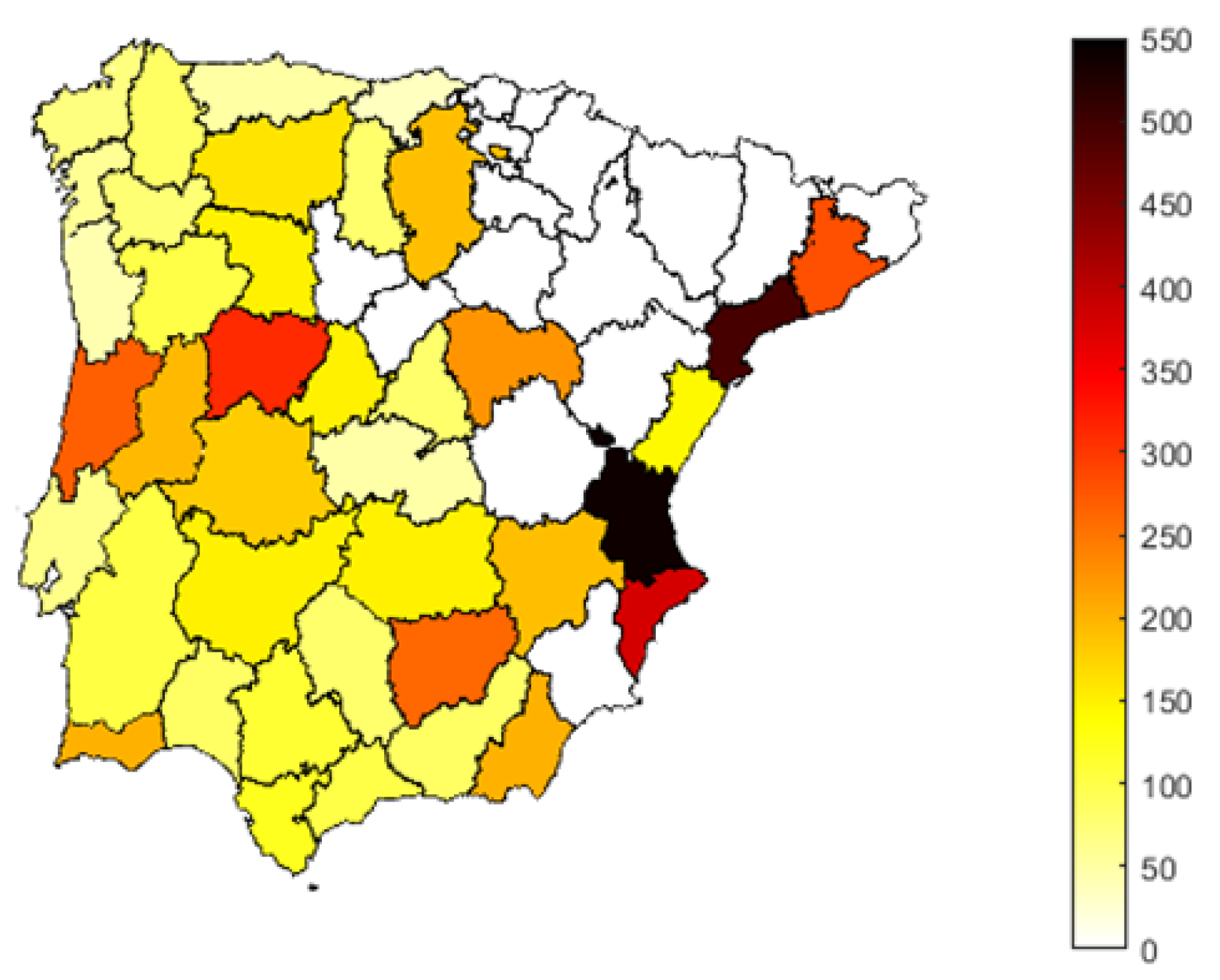
Following the definition proposed by Ruffault et al. (2016) [5], each fire event was classified into four classes according to the final burned area. Each class is defined by the calculation of percentiles 1, 85, 95 and 98. Thus, within the scope of this work, a fire was considered a large fire if the burned area presented a value higher than that of the 95th percentile of the respective distribution and it was classified as a very large fire if it surpassed the 98th percentile. In order to facilitate the analysis, the large fire percentile values are shown in Figure 2. In addition, provinces with a number of large fires below the 25th percentile (at the Iberian Peninsula level) were excluded (Figure 2, white provinces) and are not considered in the analysis.

3.2. Cluster Analysis: K-Means and Composite Analysis

A cluster analysis algorithm based on the K-means method was applied to identify the FWT based on standardized local-scale anomalies associated with the large fires previously identified for each of the Iberian Peninsula provinces. The K-means algorithm aggregates data by separating samples in K groups of equal variance, such that the squared error between the empirical mean of a cluster and the points in the cluster is minimized (minimizing the inertia or within-of-squares). The ‘gap’ method was used before applying the cluster analysis to estimate the optimum number of clusters [43]. Afterwards, a composite analysis was performed following the approach introduced by Ruffault et al. (2016,2018) [5,16] for different temporal scales, namely twenty days (ten days before and in the ten days after the day of the beginning of the fire) and nine months (seven months before the fire month and two months after), to capture the synoptic and interannual variability, respectively.

4. Results

4.1. Large Fires in the Iberian Peninsula

The burned area thresholds relative to large fires are quite different among the regions (Figure 2). The eastern provinces of the Iberian Peninsula and central Portugal present the highest values of the 95th percentile of the respective distribution of burned area in those regions. It is worth noticing the relatively wide range of values obtained for the 95th percentile thresholds. These range from low values observed for several provinces in the north-western sector of Iberia (95th percentile < 100 ha) and considerably larger values in the Mediterranean coastal area (95th percentile > 300 ha). These differences are mostly due to the very different fire regimes observed in these different areas, with the north-western region being characterized by many smaller fires than the other provinces of both Portugal [36] and Spain [44]. On the contrary, the Mediterranean sector has less fires but quite often with a large burned area [44].
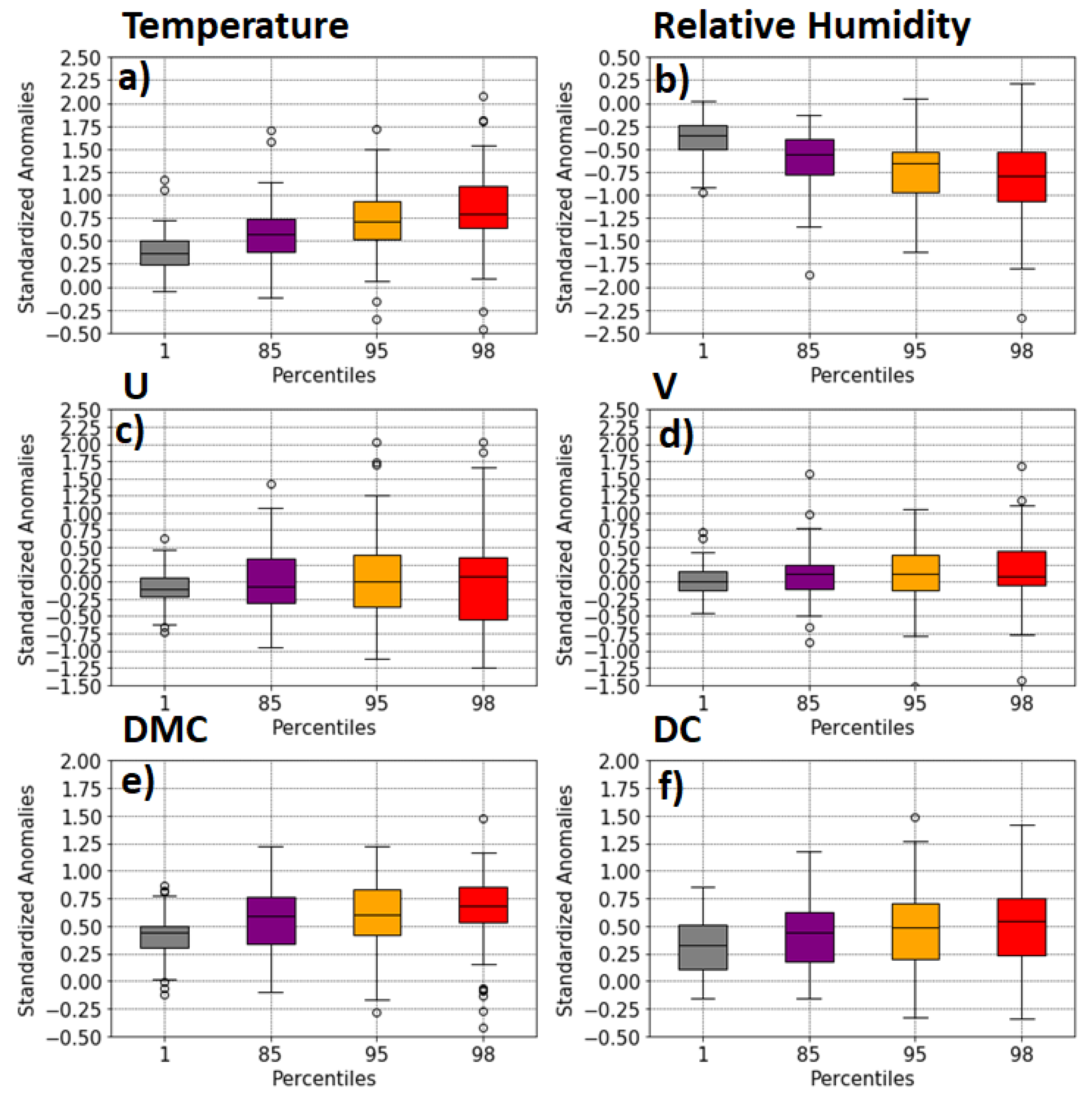
The averaged standardized anomalies of the meteorological variables on the day of ignition of varying burned area percentiles are represented in Figure 3. The anomalies of temperature and relative humidity increase in modulus according to the value increase in the total burned area of the events for the Iberian Peninsula. For the case of temperature, the median standardized anomalies of the fire day are always positive and follow the behavior already described, i.e., fires with a higher burned area are associated with days with higher temperature anomalies. Conversely, relative humidity shows median anomalies for the day of the ignitions which are increasingly negative for fires with higher burned areas. The fires above the 95th (and 98th) percentile stand out with the highest anomalies of temperature and relative humidity for all classes of burned areas. Conversely, anomalies of zonal and meridional wind velocity present a near-zero standardized anomaly with increasing spread as burned area percentile increases. Moreover, the zonal wind anomalies on the fire ignition day present higher variability compared to meridional wind anomalies. Therefore, the zonal wind speed was chosen to identify different Fire Weather Types (FWTs) associated with the occurrence of large fires in the Iberian Peninsula. The negative (positive) anomalies are indicative of prevailing winds from the eastern (western) quadrant.
A similar analysis was made for the drought-related FWI indices (Figure 3 e,f), Duff Moisture Code(DMC) and Drought Code (DC), displaying the standardized anomalies of the indices of fuel dryness. As in the case of the majority of the meteorological variables, DMC and DC present higher anomalies for higher burned areas, and the median anomalies are always positive. The magnitude of DMC- and DC-standardized anomalies, at this timescale, are similar. However, the range of values associated with DC is larger when compared to the range of values of DMC, suggesting that Iberian Peninsula fires occur under different dryness conditions.

4.2. Fire Weather Types

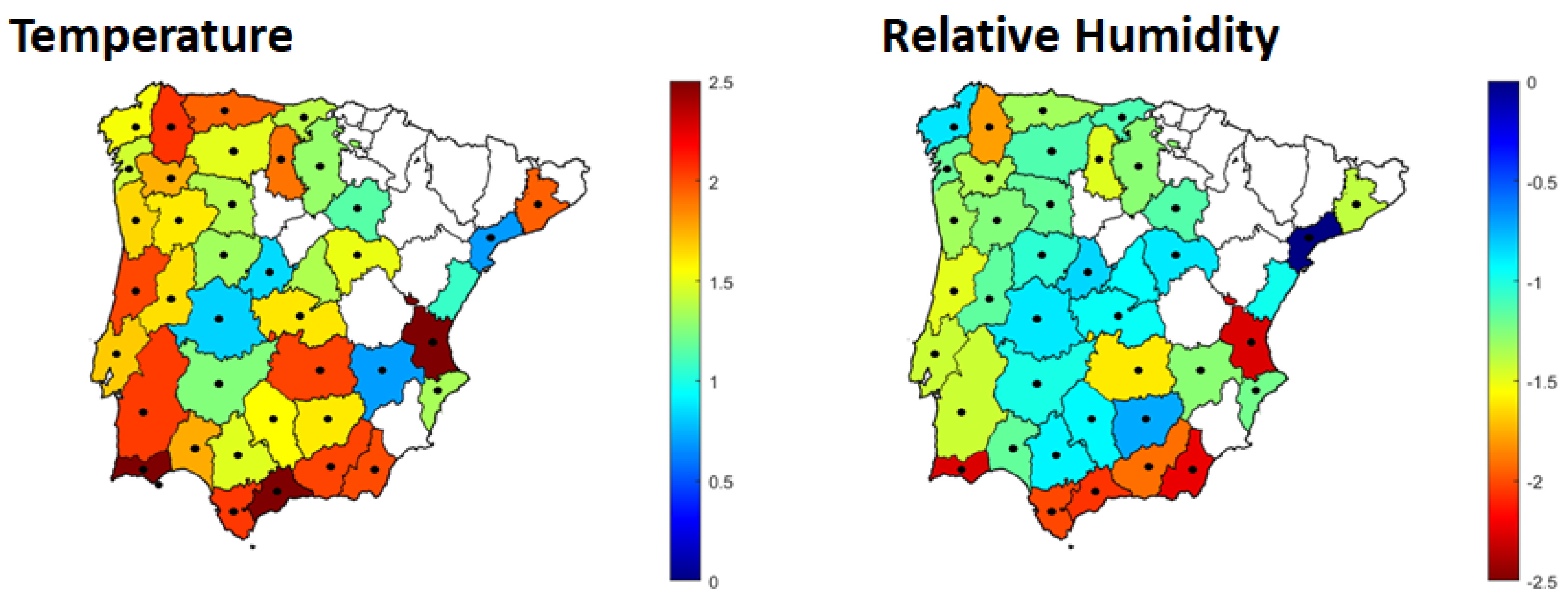
Three distinct fire weather types were identified based on the application of the K-means algorithm to the standardized anomalies of temperature, relative humidity and zonal wind velocity measured for the days of ignition in each region. The first weather type identified, hereafter FWT1 (fire weather type 1) (Figure 4), is characterized by high positive temperature anomalies (above one standard deviation), and strong negative relative humidity anomalies (above one standard deviation). It is important to stress that the anomalies of each of the analyzed variables are different among all the regions.
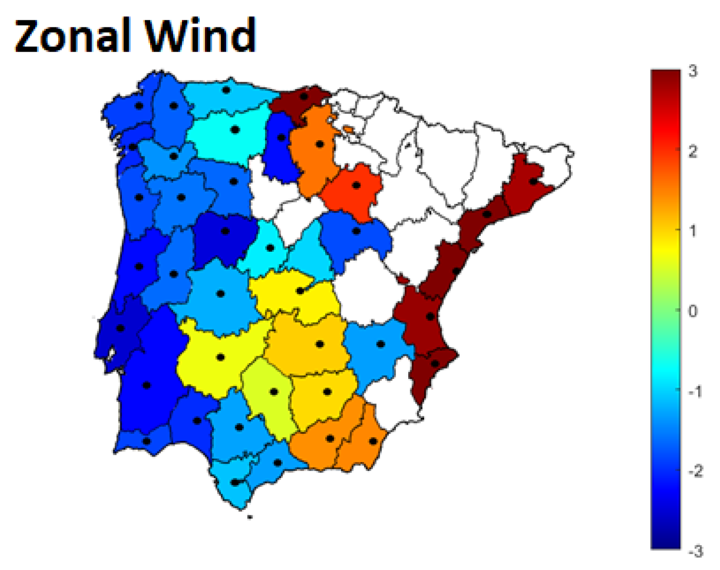
The second weather type identified, hereafter FWT2 (fire weather type 2) (Figure 5), is characterized by high wind speed anomalies (above one standard deviation). Most of the western and several central Iberian regions are characterized by negative standardized anomalies of the zonal wind velocity. As in the case of the analysis of the meteorological variables, the negative signal of the zonal wind speed anomalies is indicative of easterly winds. However, for the eastern regions of Iberia, FWT2 presents zonal wind anomalies above two standard deviations, with prevailing westerly winds. Conversely, a third fire weather type was identified by cluster analysis, not configuring any extreme weather conditions. However, it should be noted that this last fire weather type is not statistically significant when applying the Kruskal–Wallis test (95% significance) [45] in most provinces. So the weather conditions associated with this fire weather type are not so relevant in triggering and in the propagation of large fires. While fuel dryness is an important factor, this fire weather type was not analyzed further due to the lack of statistical significance at this timescale.
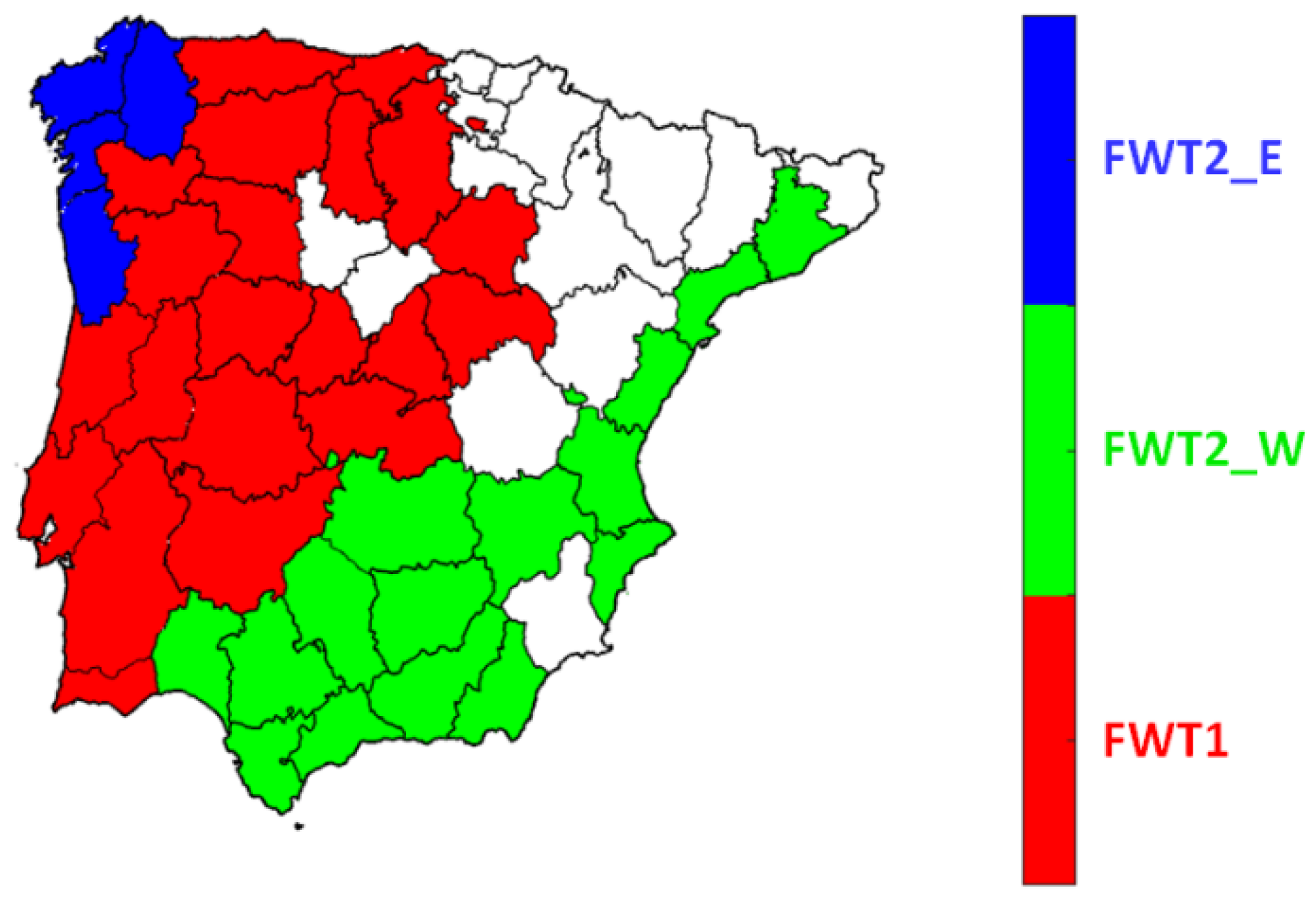
To assess the importance of the fire weather types, Figure 6 illustrates the predominant mode in each province with a higher percentage of burned area associated with large fires identified for the considered period. Consequently, three distinct large regions in the Iberian Peninsula were identified: (1) FWT1, in red, is responsible for the largest amount of burned area in most provinces; (2) FWT2_E (fire weather type 2_east), in blue, provinces where the easterly winds are predominant, which are concentrated in the northwest regions of the Iberian Peninsula; (3) FWT2_W (fire weather type 2_west), in green, predominates in the easternmost provinces of the Iberian Peninsula and is controlled by westerly winds.

4.3. Fire Weather Type Characterization

4.3.1. Shorter Timescales

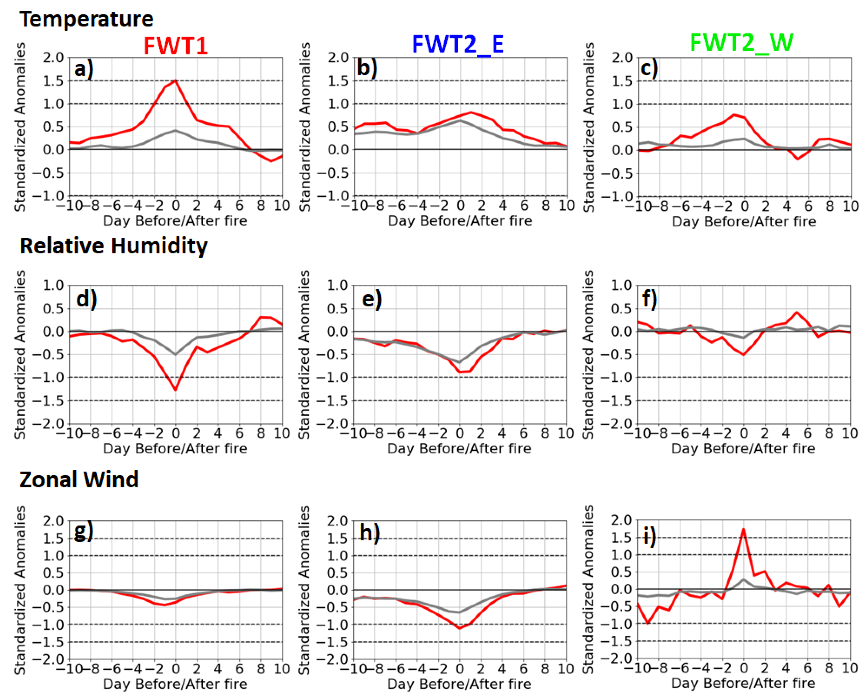
The use of composites for all fires (grey) and large fires (red) is intended to evaluate the influence of each of the meteorological variables on fires and how activity associated with large fires differs from activity associated with all fires on a wider 20 day timescale, in this case, for the three identified regions with the same predominant fire weather types (Figure 7). Unlike temperature and relative humidity, the zonal wind has a restricted influence on the fire ignition day itself. In all cases, the anomalies decrease immediately after that day. However, for provinces where FWT2_E and FWT2_W are predominant (respectively green and blue color, Figure 7), there is a greater difference between the anomalies for all the fires and the large fires composite. It is verified that the peak of zonal wind is well marked for the ignition day (Figure 7g–i), while the days before the fire day present near-zero anomalies and in the two days immediately after the day of the beginning of the fire, the anomalies return to the average values. In contrast, provinces where FWT1 stands out (red color Figure 6 and Figure 7a–c) show both the temperature and relative humidity with clear, strong anomalies. However, contrary to the wind, the effect of these two variables is not restricted to the fire ignition day but starts several days before. In these provinces, for both temperature and relative humidity, the distribution of the anomaly values for large fires is separated from all fire anomalies up to four days before the fire day, where the maximum value of the anomaly is reached and decreases two days immediately after ignition day.

4.3.2. Monthly Timescales

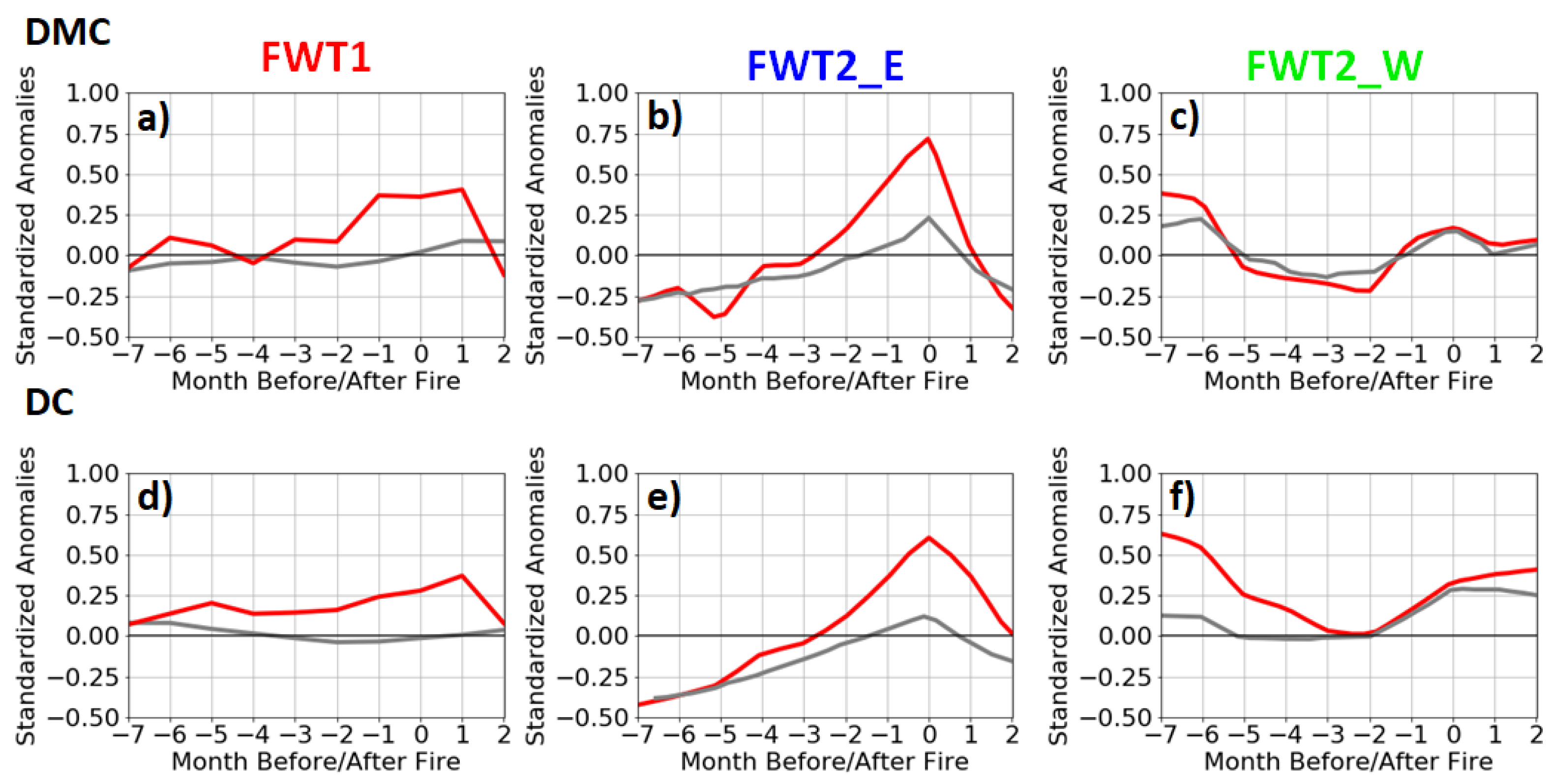
For a monthly timescale, the composites of the standardized anomalies of the DMC and DC of the three identified regions show distinct behavior between all fire (gray) activity and the distribution of anomalies of large fires (red, Figure 8). This longer timescale is appropriate to infer the dryness, not only of the fuels at different depths but also of the soil dryness itself, since both variables depend on precipitation and temperature, functioning as proxies of the drought and indicative of the pre-season fire conditions.
Although with different levels of standardized anomalies, two to four months before the fire, the DMC anomalies for the large fires generally start to rise, while the same increase becomes evident only a month before for the all-fires curve (gray). Moreover, for provinces where FWT1 (Figure 8a,d) and FWT2_E (Figure 8b,e) predominate, there is a clear difference in the distribution of anomalies between all the fires and the large fires, making it possible to identify an increase in the large fires anomalies three months before the fire season. On the contrary, for FWT2_W (Figure 8c,f), monthly DMC anomalies are practically identical independently of the fire sizes.
The monthly distributions of the DC anomalies of all fires and the large fires are not coincidental, except for provinces controlled by the westerly wind FWT and these continue rising approximately two months after the fire season. For FWT1, the distribution of the monthly anomalies associated with the large fires always stays significantly above the corresponding all fires curve, likely implying that large fires tend to be associated with considerably drier seasons. On the other hand, for provinces where FWT2_E is responsible for the largest amount of burned area, DC presents the same behavior as DMC but with lower anomaly values. We are not sure why FWT_E shows such negative anomalies several months prior to the fire event. It appears to be a climatological feature because between −5 and −7 months, there is almost no difference between the all fires and large fires curves. On the contrary, closer to the fire event (i.e., months −2 to −1), there is a large difference between the all fires and large fires curves for both DC and DMC, stressing the relevance of this parameter for the large fires of this cluster.

5. Discussion

This study analyzes historical meteorological data and fire records for both Iberian countries (Portugal and Spain) aiming to classify summer large fires according to their forcing local-scale weather conditions at the surface (i.e., temperature, relative humidity, wind speed) and two fire danger weather indices from the Canadian FWI, Duff Moisture Code (DMC) and Drought Code (DC). Based on the historical data, large fires were identified according to a threshold approach for fifty-four different regions of the Iberian Peninsula. The very different threshold values identified for each province support the hypothesis that a one-fits-all large fires threshold definition should be avoided, as each province is characterized by a specific fire regime which causes that large fires to be triggered by different conditions.
In order to identify the different climatic conditions associated with the occurrence of large fires for each province, a cluster analysis was applied to all provinces based on standardized anomalies of temperature, relative humidity and zonal wind velocity in large fires days. This analysis allowed the identification of two significant FWTs (FWT1 and FWT2) in the Iberian Peninsula that spatially aggregated into three major regions.
The meteorological characteristics associated with FWT1, namely high temperature and low relative humidity, are described as among the predominant conditions associated with the occurrence of large fires in the Iberian Peninsula. Pereira et al. (2005) [11] have shown that large fires in Portugal are mostly related to anomalous advection of hot and dry air from Northern Africa and through central Iberia, associated with high temperatures and low relative humidity. In this context, Trigo et al. (2006) [13] have shown that the exceptional fire season of 2003 in Portugal was characterized by significant anomalies of surface meteorological variables, namely with positive anomalies in surface maximum and minimum temperature and low relative humidity. In fact, in the Iberian Peninsula, this FWT is predominant in many provinces, contributing significantly to the occurrence of large fires, unlike other Mediterranean regions, such as southern France [5,16].
FWT2 is mainly characterized by substantial wind anomalies, and it includes most of the Iberian Peninsula Mediterranean provinces. The large fires days associated with this FWT present distinct wind characteristics, where provinces classified as FWT2_E and FWT2_W are dominated by east and westerly winds, respectively. Thus, large fires which occur in the western sector of the Iberian Peninsula are essentially associated with easterly winds, while westerly winds mostly control large fires occurring in the eastern sector. This is in accordance with the work by Hoinka et al. (2009) [46], which evaluated the evolution of synoptic and mesoscale wind, temperature and humidity patterns during wildland fire events above 500 ha in Portugal. This study concluded that for the fire day, most of the fires present winds with an eastern component, with air being advected from the interior of Spain. Likewise, a study performed by Rasilla et al. (2010) [47] showed that the eastern sector of the Iberian Peninsula is characterized by westerly winds that contribute to the displacement of air masses from the Atlantic, which cross over the Spanish mainland and cause a strong drying and warming that contributes to increasing the risk of wildfire occurrence [48]. Our findings of two predominant wind regimes associated with large fires days support the results of these two studies. Moreover, a FWT dominated by wind components was also identified as being associated with the occurrence of large fires days in southern France [5,16]. However, contrary to what happens in the Iberian Peninsula, where FWT1 is responsible for the largest amount of burned area in most provinces, in the Mediterranean region of France, wind is the meteorological variable that contributes to the largest amount of burned area associated with the large fires events [5].
In order to distinguish the importance of the different variables that are related to the occurrence of the large fires at different timescales in the three identified regions, a composite analysis was applied. At the shorter timescales (20 days), meteorological variables override the influence of the drought-related FWI indices, but with different lags for the regions under study. The wind has a restricted influence on the fire day and is the dominant factor of both variants of FWT2. The anomalies of temperature and relative humidity reveal a significant separation between the all fires and large fires’ curves, although with different lags for the three regions. At longer timescales (9 months), compatible with interannual variations of the pre-fire season and drought-proxy conditions, DMC and DC, present a considerable difference between activity associated with all fires and large fires, although at different lags for each region.
The current assessment stands out from previous studies in several aspects, namely (1) the validity of considering a variable threshold is proven; (2) the use of a longer fire database (35 years) allows the identification of more reliable climatologies; (3) the identification of three FWTs at the Iberian Peninsula level highlights the necessity to study the conditions leading to large fires at the local/regional scale; (4) the relevance of each FWT identified varies significantly in all provinces, proving that large fires spread depends on different meteorological conditions according to geographic location; (5) the importance associated with the dryness of fuels is not uniform in the Iberian Peninsula and operates at different timescales. Nevertheless, we should acknowledge that, similarly to Rodrigues et al. (2020) [37], we have also only considered the fire ignition day when identifying large fires.

6. Conclusions and Future Work

This study proposes to classify summer large fires for fifty-four provinces of the Iberian Peninsula according to their local-scale weather conditions based on composite and cluster analysis. Based on the proposed methodology, it was possible to determine that the definition of a large fire varies at the provincial level, which suggests that the use of a single threshold for large areas is somewhat misleading. Another aspect which should be highlighted is the fact that three Fire Weather Types (FWTs) were identified at the Iberian Peninsula level, although with contrasting characteristics, highlighting the variability of large fires at a more regional scale. Finally, it was possible to conclude that climate and weather do not have a similar influence throughout the Iberian Peninsula, also showing that the dryness of fuels is not uniform in the region and operates at different timescales.
The relevance of this research is particularly significant within the context of climate change scenarios for the western Mediterranean. Taking into account the projected rise in temperature and drought frequency as well as a decrease in precipitation for the Mediterranean region [49], this could lead to an increase in heatwaves, characterized by days with considerable above-normal temperatures, in the future. Since we have detected that FWT1 is an important FWT in the Iberian Peninsula, particularly well associated with the development of large fires, it is expected that this could drive an increase in large fires’ events in the western Mediterranean. Therefore, as future work, the identified climatologies may be included in future projections to estimate the variability of these variables and frequency of FWTs in order to improve our knowledge on future conditions associated with large fires in this part of the globe.

Author Contributions

I.V. run the models to extract the fire patterns and links with climate variables. A.R. and R.M.T. provided the conceptual framework. All authors contributed to the writing and revising of the manuscript. All authors have read and agreed to the published version of the manuscript.

Funding

This work was supported by national funds through FCT (Fundação para a Ciência e a Tecnologia, Portugal) under project IMPECAF -PTDC/CTA-CLI/28902/2017, and project UIDB/50019/2020 - IDL.

Acknowledgments

The authors thank Miguel M. Pinto for extracting the ERA-Interim reanalysis, the MSG and the FWI data used in this study.

Conflicts of Interest

The authors declare no conflict of interest.

References

  1. Bowman, D.M.J.S.; Balch, J.K.; Artaxo, P.; Bond, W.J.; Carlson, J.M.; Cochrane, M.A.; D’Antonio, C.M.; De Fries, R.S.; Doyle, J.C.; Harrison, S.P.; et al. Fire in the earth system. Science 2009, 324, 481–484. [Google Scholar] [CrossRef] [PubMed]
  2. Archibald, S.; Lehmann, C.E.R.; Gómez-Dans, J.L.; Bradstock, R.A. Defining pyromes and global syndromes of fire regimes. Proc. Natl. Acad. Sci. USA 2013, 110, 6442–6447. [Google Scholar] [CrossRef] [PubMed] [Green Version]
  3. Turco, M.; Von Hardenberg, J.; AghaKouchak, A.; Llasat, M.C.; Provenzale, A.; Trigo, R.M. On the key role of droughts in the dynamics of summer fires in Mediterranean Europe. Sci. Rep. 2017, 7, 81. [Google Scholar] [CrossRef] [PubMed] [Green Version]
  4. Trigo, R.M.; Sousa, P.M.; Pereira, M.G.; Rasilla, D.; Gouveia, C.M. Modelling wildfire activity in Iberia with different atmospheric circulation weather types. Int. J. Climatol. 2013, 36, 2761–2778. [Google Scholar] [CrossRef]
  5. Ruffault, J.; Moron, V.; Trigo, R.M.; Curt, T. Objective identification of multiple large fire climatologies: An application to a Mediterranean ecosystem. Environ. Res. Lett. 2016, 11, 075006. [Google Scholar] [CrossRef] [Green Version]
  6. Pinto, M.M.; DaCamara, C.C.; Trigo, I.F.; Trigo, R.M.; Turkman, K.F. Fire danger rating over Mediterranean Europe based on fire radiative power derived from Meteosat. Nat. Hazards Earth Syst. Sci. 2018, 18, 515–529. [Google Scholar] [CrossRef] [Green Version]
  7. Sousa, P.M.; Trigo, R.M.; Pereira, M.G.; Bedia, J.; Gutiérrez, J.M. Different approaches to model future burnt area in the Iberian Peninsula. Agric. For. Meteorol. 2015, 202, 11–25. [Google Scholar] [CrossRef]
  8. Sánchez-Benítez, A.; García-Herrera, R.; Barriopedro, D.; Sousa, P.M.; Trigo, R.M. June 2017: The Earliest European Summer Mega-heatwave of Reanalysis Period. Geophys. Res. Lett. 2018, 45, 1955–1962. [Google Scholar] [CrossRef]
  9. Costa, L.; Thonicke, K.; Poulter, B.; Badeck, F. Sensitivity of Portuguese forest fires to climatic, human, and landscape variables: Subnational differences between fire drivers in extreme fire years and decadal averages. Reg. Environ. Chang. 2011, 11, 543–551. [Google Scholar] [CrossRef]
  10. Pausas, J.G.; Vallejo, V.R. The role of fire in European Mediterranean ecosystems. In Remote Sensing of Large Wildfires; Springer: Berlin/Heidelberg, Germany, 1999; pp. 3–16. [Google Scholar]
  11. Pereira, M.G.; Trigo, R.M.; Da Camara, C.C.; Pereira, J.M.C.; Leite, S.M. Synoptic patterns associated with large summer forest fires in Portugal. Agric. For. Meteorol. 2005, 129, 11–25. [Google Scholar] [CrossRef]
  12. Flannigan, M.D.; Stocks, B.J.; Wotton, B.M. Climate change and forest fires. Sci. Total Environ. 2000, 262, 221–229. [Google Scholar] [CrossRef]
  13. Trigo, R.M.; Pereira, J.M.C.; Pereira, M.G.; Mota, B.; Calado, T.J.; Dacamara, C.C.; Santo, F.E. Atmospheric conditions associated with the exceptional fire season of 2003 in Portugal. Int. J. Climatol. 2006, 26, 1741–1757. [Google Scholar] [CrossRef]
  14. Turco, M.; Llasat, M.C.; Von Hardenberg, J.; Provenzale, A. Impact of climate variability on summer fires in a Mediterranean environment (northeastern Iberian Peninsula). Clim. Chang. 2013, 116, 665–678. [Google Scholar] [CrossRef]
  15. Amraoui, M.; Pereira, M.G.; DaCamara, C.C.; Calado, T.J. Atmospheric conditions associated with extreme fire activity in the Western Mediterranean region. Sci. Total Environ. 2015, 524–525, 32–39. [Google Scholar] [CrossRef] [PubMed]
  16. Ruffault, J.; Curt, T.; Martin-Stpaul, N.K.; Moron, V.; Trigo, R.M. Extreme wildfire events are linked to global-change-type droughts in the northern Mediterranean. Nat. Hazards Earth Syst. Sci. 2018, 18, 847–856. [Google Scholar] [CrossRef] [Green Version]
  17. Gouveia, C.M.; Bistinas, I.; Liberato, M.L.R.; Bastos, A.; Koutsias, N.; Trigo, R. The outstanding synergy between drought, heatwaves and fuel on the 2007 Southern Greece exceptional fire season. Agric. For. Meteorol. 2016, 218–219, 135–145. [Google Scholar] [CrossRef]
  18. Russo, A.; Gouveia, C.M.; Páscoa, P.; DaCamara, C.C.; Sousa, P.M.; Trigo, R.M. Assessing the role of drought events on wildfires in the Iberian Peninsula. Agric. For. Meteorol. 2017, 237–238, 50–59. [Google Scholar] [CrossRef]
  19. Barbero, R.; Abatzoglou, J.T.; Kolden, C.A.; Hegewisch, K.C.; Larkin, N.K.; Podschwit, H. Multi-scalar influence of weather and climate on very large-fires in the Eastern United States. Int. J. Climatol. 2015, 35, 2180–2186. [Google Scholar] [CrossRef]
  20. Riley, K.L.; Abatzoglou, J.T.; Grenfell, I.C.; Klene, A.E.; Heinsch, F.A. The relationship of large fire occurrence with drought and fire danger indices in the western USA, 1984–2008: The role of temporal scale. Int. J. Wildland Fire 2013, 22, 894–909. [Google Scholar] [CrossRef]
  21. Gouveia, C.M.; Bastos, A.; Trigo, R.M.; Dacamara, C.C. Drought impacts on vegetation in the pre- and post-fire events over Iberian Peninsula. Nat. Hazards Earth Syst. Sci. 2012, 12, 3123–3137. [Google Scholar] [CrossRef]
  22. Wilson, A.M.; Latimer, A.M.; Silander, J.A. Climatic controls on ecosystem resilience: Postfire regeneration in the Cape Floristic Region of South Africa. Proc. Natl. Acad. Sci. USA 2015, 112, 9058–9063. [Google Scholar] [CrossRef] [PubMed] [Green Version]
  23. Dimitrakopoulos, A.P.; Vlahou, M.; Anagnostopoulou, C.G.; Mitsopoulos, I.D. Impact of drought on wildland fires in Greece: Implications of climatic change? Clim. Chang. 2011, 109, 331–347. [Google Scholar] [CrossRef]
  24. Dimitrakopoulos, A.; Gogi, C.; Stamatelos, G.; Mitsopoulos, I. Statistical analysis of the fire environment of large forest fires (>1000 ha) in Greece. Pol. J. Environ. Stud. 2011, 20, 327–332. [Google Scholar]
  25. Koutsias, N.; Arianoutsou, M.; Kallimanis, A.S.; Mallinis, G.; Halley, J.M.; Dimopoulos, P. Where did the fires burn in Peloponnisos, Greece the summer of 2007? Evidence for a synergy of fuel and weather. Agric. For. Meteorol. 2012, 156, 41–53. [Google Scholar] [CrossRef]
  26. Tedim, F.; Remelgado, R.; Borges, C.; Carvalho, S.; Martins, J. Exploring the occurrence of mega-fires in Portugal. For. Ecol. Manag. 2013, 294, 86–96. [Google Scholar] [CrossRef]
  27. Barriopedro, D.; Fischer, E.M.; Luterbacher, J.; Trigo, R.M.; García-Herrera, R. The hot summer of 2010: Redrawing the temperature record map of Europe. Science 2011, 332, 220–224. [Google Scholar] [CrossRef] [Green Version]
  28. Ribeiro, L.; Viegas, D.X.; McGee, T.; Pereira, M.; Parente, J.X.; Gavriil Leone, V.; Delogu, G.; Hardin, H. Extreme wildfires and disasters around the world: Lessons to be learned. Extrem. Wildfire Events Disasters 2020, 31–51. [Google Scholar] [CrossRef]
  29. Parente, J.; Pereira, M.G.; Tonini, M. Space-time clustering analysis of wildfires: The influence of dataset characteristics, fire prevention policy decisions, weather and climate. Sci. Total Environ. 2016, 559, 151–165. [Google Scholar] [CrossRef]
  30. Barbero, R.; Abatzoglou, J.T.; Steel, E.A.; Larkin, N.K. Modeling very large-fire occurrences over the continental United States from weather and climate forcing. Environ. Res. Lett. 2014, 9, 124009. [Google Scholar] [CrossRef]
  31. Ganteaume, A.; Camia, A.; Jappiot, M.; San-Miguel-Ayanz, J.; Long-Fournel, M.; Lampin, C. A review of the main driving factors of forest fire ignition over Europe. Environ. Manag. 2013, 51, 651–662. [Google Scholar] [CrossRef] [PubMed] [Green Version]
  32. Bedia, J.; Herrera, S.; Gutiérrez, J.M.; Benali, A.; Brands, S.; Mota, B.; Moreno, J.M. Global patterns in the sensitivity of burned area to fire-weather: Implications for climate change. Agric. For. Meteorol. 2015, 214–215, 369–379. [Google Scholar] [CrossRef] [Green Version]
  33. Turco, M.; Rosa-Cánovas, J.J.; Bedia, J.; Jerez, S.; Montávez, J.P.; Llasat, M.C.; Provenzale, A. Exacerbated fires in Mediterranean Europe due to anthropogenic warming projected with non-stationary climate-fire models. Nat. Commun. 2018, 9, 3821. [Google Scholar] [CrossRef] [PubMed]
  34. Turco, M.; Jerez, S.; Augusto, S.; Tarín-Carrasco, P.; Ratola, N.; Jiménez-Guerrero, P.; Trigo, R.M. Climate drivers of the 2017 devastating fires in Portugal. Sci. Rep. 2019, 9, 1–8. [Google Scholar] [CrossRef] [PubMed]
  35. Van Wagner, C.E. Development and Structure of the Canadian Forest Fire Weather Index System Chalk River; Forest Technical Report; Environment Canada, Canadian Forest Service, Petawawa Forest Experiment Station: Chalk River, ON, Canada, 1987; 35p.
  36. Field, R.D.; Spessa, A.C.; Aziz, N.A.; Camia, A.; Cantin, A.; Carr, R.; De Groot, W.J.; Dowdy, A.J.; Flannigan, M.D.; Manomaiphiboon, K.; et al. Development of a Global Fire Weather Database. Nat. Hazards Earth Syst. Sci. 2015, 15, 1407–1423. [Google Scholar] [CrossRef] [Green Version]
  37. Rodrigues, M.; Trigo, R.M.; Vega-García, C.; Cardil, A. Identifying large fire weather typologies in the Iberian Peninsula. Agric. For. Meteorol. 2020, 280, 107789. [Google Scholar] [CrossRef]
  38. ICNF (Institute of Nature Conservation and Forests). Available online: http://www2.icnf.pt/portal/florestas/dfci/inc/estat-sgif (accessed on 1 March 2020).
  39. Pereira, M.G.; Malamud, B.D.; Trigo, R.M.; Alves, P.I. The history and characteristics of the 1980–2005 Portuguese rural fire database. Nat. Hazards Earth Syst. Sci. 2011, 11, 3343–3358. [Google Scholar] [CrossRef]
  40. MARM (Ministry of Environment and Rural and Marine Affairs). Available online: https://www.mapa.gob.es/es/desarrollo-rural/estadisticas/Incendios_default.aspx (accessed on 1 March 2020).
  41. Dee, D.P.; Uppala, S.M.; Simmons, A.J.; Berrisford, P.; Poli, P.; Kobayashi, S.; Andrae, U.; Balmaseda, M.A.; Balsamo, G.; Bauer, P.; et al. The ERA-Interim reanalysis: Configuration and performance of the data assimilation system. Q. J. R. Meteorol. Soc. 2011, 137, 553–597. [Google Scholar] [CrossRef]
  42. Lawrence, M.G. The relationship between relative humidity and the dewpoint temperature in moist air: A simple conversion and applications. Bull. Am. Meteorol. Soc. 2005, 86, 225–233. [Google Scholar] [CrossRef]
  43. Tibshirani, R.; Walther, G.; Hastie, T. Estimating the number of clusters in a data set via the gap statistic. Series B: Statistical Methodology. J. R. Stat. Soc. 2001, 63, 411–423. [Google Scholar] [CrossRef]
  44. Jiménez-Ruano, A.; Mimbrero, M.R.; De la Riva Fernández, J. Understanding wildfires in mainland Spain. A comprehensive analysis of fire regime features in a climate-human context. Appl. Geogr. 2017, 89, 100–111. [Google Scholar]
  45. Kruskal, W.H.; Wallis, W.A. Use of ranks in one-criterion variance analysis. J. Am. Stat. Assoc. 1952, 47, 583–621. [Google Scholar] [CrossRef]
  46. Hoinka, K.P.; Carvalho, A.; Miranda, A.I. Regional-scale weather patterns and wildland fires in central Portugal. Int. J. Wildland Fire 2009, 18, 36–49. [Google Scholar] [CrossRef] [Green Version]
  47. Rasilla, D.F.; García-Codron, J.C.; Carracedo, V.; Diego, C. Circulation patterns, wildfire risk and wildfire occurrence at continental Spain. Phys. Chem. Earth 2010, 35, 553–560. [Google Scholar] [CrossRef]
  48. Peña-Angulo, D.; Trigo, R.M.; Cortesi, N.; González-Hidalgo, J.C. The influence of weather types on the monthly average maximum and minimum temperatures in the Iberian Peninsula. Atmos. Res. 2016, 178–179, 217–230. [Google Scholar] [CrossRef]
  49. IPCC. Global Warming of 1.5 °C; IPCC: Geneva, Switzerland, 2018. [Google Scholar]
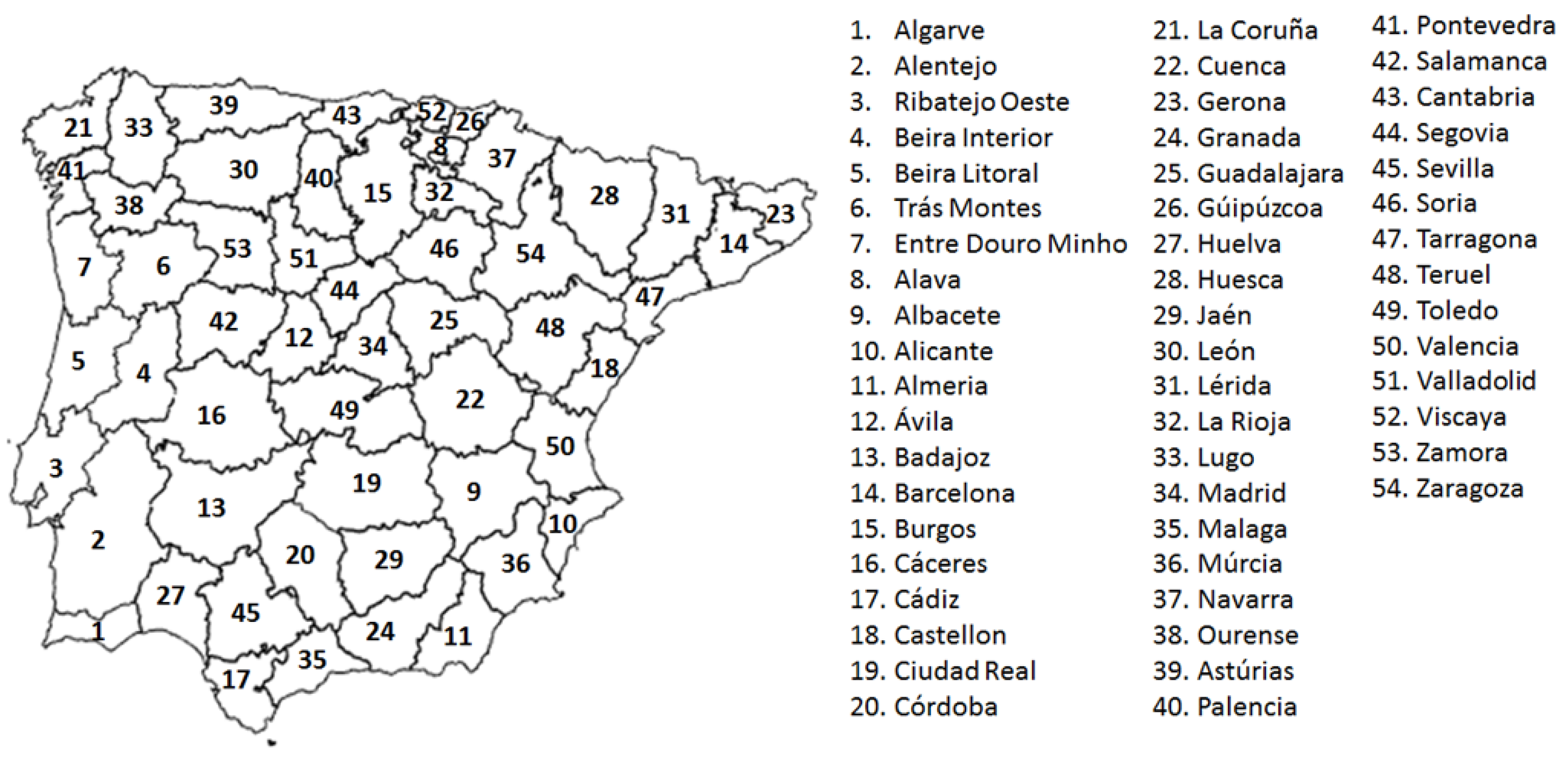
Figure 1. Geographical boundaries of the fifty-four regions of the Iberian Peninsula.
Forests 11 00547 g001
Figure 2. Representation of 95th percentile of burned area (ha) for each of the provinces of the Iberian Peninsula. Provinces with very few large fires are represented in white and were disregarded.
Forests 11 00547 g002
Figure 3. Standardized anomalies for the ignition days of (a) temperature, (b) relative humidity, (c) zonal (U) and (d) meridional (V) velocity of the wind, (e) Duff Moisture Code (DMC) and (f) Drought Code (DC) in the Iberian Peninsula according to the final burned area percentiles 1 (gray), 85 (purple), 95 (orange), and 98 (red).
Forests 11 00547 g003
Figure 4. Standardized anomalies of the temperature and relative humidity values for large fires days under FWT1 (fire weather type 1) conditions in each province The point indicates whether the fire weather type represented is statistically significant at the province level (Kruskal–Wallis non-parametric test with 95% significance). Provinces with very few large fires are represented in white and were disregarded.
Forests 11 00547 g004
Figure 5. Standardized anomalies of the zonal wind velocity for the large fires days under FWT2 (fire weather type 2) conditions in each province. The point indicates whether the fire weather type represented is statistically significant at the province level (Kruskal–Wallis non-parametric test with 95% significance). Provinces with very few large fires are represented in white and were disregarded.
Forests 11 00547 g005
Figure 6. Representation of the predominant fire weather types in each province. Fire weather type 1 (FWT1) is represented in red in provinces where temperature and relative humidity dominate. FWT2 (fire weather type 2) is represented in blue, FWT2_E (fire weather type 2_east), and green, FWT2_W (fire weather type 2_west), in provinces where the east or west zonal wind controls large fires activity, respectively. Provinces with very few large fires are represented in white and were disregarded.
Forests 11 00547 g006
Figure 7. Composites of the standardized anomalies of the (ac) temperature, (df) relative humidity and (gi) zonal wind at 20 day timescales for all fires (gray) and large fires (red) associated with the three large regions identified in Figure 6 with the same predominant fire weather type.
Forests 11 00547 g007
Figure 8. As in Figure 7, but for (ac) Duff Moisture Code (DMC) and (df) Drought Code (DC) at 9 month timescales.
Forests 11 00547 g008