Article

Minor Soil Elements in Contrasting Profiles in an Area Frequently Affected by Fire, NE Iberian Peninsula

by
Marcos Francos
1,2,*,
Carlos Sánchez-García
3,4,*,
Oscar Corvacho-Ganahín
5 and
Víctor Fernández-García
6,7
1
Department of Geography, Faculty of Geography and History, University of Salamanca, C/Cervantes s/n, 37002 Salamanca, Spain
2
Centro de Investigación de Estudios Avanzados del Maule (CIEAM), Universidad Católica del Maule, Av. San Miguel 3605, Talca 3466706, Chile
3
PaleoRisk Research Group, Departamento de Geografía, Facultad de Geografía e Historia, Universidad de Barcelona, C/Montalegre 6, 08001 Barcelona, Spain
4
IPHES Catalan Institute for Human Palaeoecology and Social Evolution, 43007 Tarragona, Spain
5
Departamento de Ciencias Históricas y Geográficas, Universidad de Tarapacá, 18 de Septiembre 2222, Arica 1000000, Chile
6
Área de Ecología, Facultad de Ciencias Biológicas y Ambientales, Universidad de León, 24071 León, Spain
7
Faculty of Geosciences and Environment, Institute of Geography and Sustainability, University of Lausanne, Géopolis, CH-1015 Lausanne, Switzerland
*
Authors to whom correspondence should be addressed.
Fire 2022, 5(6), 189; https://doi.org/10.3390/fire5060189
Submission received: 18 July 2022 / Revised: 28 October 2022 / Accepted: 9 November 2022 / Published: 9 November 2022

Abstract

:
Forest fires are a major concern in Mediterranean areas, where factors such as slope and aspect determine the degree of water and nutrient retention and their availability in soil. In this work, we analysed the effects of slope and aspect on minor soil elements. The study area was located in Ódena (NE Iberian Peninsula) in a typical Mediterranean forest. Four geomorphologically representative and contrasting soil profiles were sampled from different slopes and aspects. Eleven samples were taken from each profile at different depths. The amount of extractable aluminium (Al), iron (Fe), manganese (Mn), zinc (Zn), boron (B), and lead (Pb) and the calcium (Ca):Al ratio in all horizons of each profile were determined. The results showed that Al, Fe, and Pb and the Ca:Al ratio were mainly affected by slope, whereas Mn, Zn, and B were especially conditioned by aspect. This type of study aims to determine which areas have to be managed in order to avoid not only soil contamination by heavy metals but also a shortage of certain essential nutrients for plant regeneration and, thus, improved soil quality.

1. Introduction

Soil is a nonrenewable natural resource, its formation and properties depending on multiple factors, including climate, topography, biological and human activity, lithology, and time [1]. Mediterranean areas of the Iberian Peninsula present a high vulnerability to degradation as a consequence of a climate and topography that favours erosive phenomena [2,3,4]. Climate-change projections are highly unfavourable towards the maintenance and development of protective tree cover, as well as to the land-use change resulting from rural abandonment over the last few decades. This land-use change has led to an increase in shrub density and a homogenisation of the landscape, with the typical Catalonian landscape being a “mosaic” landscape with agricultural plots mixed with forest areas; therefore, it was more homogeneous than it is now, and this change has facilitated the occurrence and spread of severe fires [5].
Due to the historical role of fire in the functioning of Mediterranean ecosystems, and the high recurrence of fires in recent decades [6], fire can be considered one of the key soil-forming factors and determinants of soil properties [7]. The heterogeneity of Mediterranean landscapes, often with rugged geography, may cause soil to develop via different dynamics following recurrent wildfires, depending on the characteristics of aspect and slope [8]. In this sense, the geomorphological characteristics of the terrain can influence soil dynamics in relation to fire because erosional phenomena generally facilitate soil loss from sloping areas and soil accumulation on flat and topographically lower areas [9,10]. Generally speaking, nutrient concentrations and, consequently, soil fertility tend to be higher in depositional areas [11]. Similarly, it has been found that, in certain Mediterranean areas, shaded mountain locations are characterised by higher plant densities, higher water availability, and the occurrence of more-fertile and nutrient-rich soils [12].
Forest fires are not only a fundamental factor that must be taken into account in the formation of Mediterranean soils, but also have a significant impact on soil properties [13]. Depending on the intensity, the temperature reached, and the residence time, fires can significantly modify soil properties [14]. In this way, mild fires that reach temperatures of around 65–100 °C in surface soil layers are able to denature proteins and, thus, affect organisms, producing a partial sterilisation of the medium and significantly reducing extracellular enzyme activity. These changes are highly relevant because the biota and extracellular enzyme activity are two of the key factors that control nutrient cycling and soil elemental composition [15,16]. When the temperatures reached are higher, other chemical and physical changes can occur, including the loss of organic matter through combustion and volatilisation, the loss of major nutrients, such as nitrogen (N) and phosphorus (P), at around 750 ºC from the ecosystem through volatilisation, and the loss of soil structure through the complete destruction of aggregates and changes in the mineralogy of clays [14,15]. However, it has been shown that the impacts of fire on ecosystems depend not only on the intensity or severity of the fire, but also on the topography of the terrain. Thus, flat or low-sloped areas, as opposed to topographically more rugged areas, allow the incorporation of ash and the consequent recovery of edaphic properties, even when the severity of the fire was high [16,17].
Fires can also cause important changes in minor soil elements that are essential for plant fertility. It has been shown that, for example, iron (Fe) and manganese (Mn) are essential for plant development, as they are involved in several physiological processes [18] and are often deficient after fires [19]. Other minor elements, such as aluminium (Al), can rapidly reach the pre-burn status after medium- or low-severity fires, while taking longer following high-severity fires, although variations in this element also tend to occur due to the type of land management and occupation [19,20,21]. Zinc (Zn) usually recovers quickly after fire disturbance [22], but it is useful to understand its dynamics in relation to topography. The scarcity of these elements in the soil may affect soil fertility; however, excesses of some of these heavy metals can result in soil contamination [1,23]. Elemental ratios, such as Ca:Al, are very interesting in that their values vary over time, with the short-term impact of fire being the key driver of such change [23,24]. Despite the potential utility of such information (e.g., soil nutrient depletion for plant recovery or soil contamination), these minor elements have been little analysed, particularly in terms of how the topography of different profiles affects their vertical distribution in an area where forest fires are recurrent. Vertical-profile analyses, through which evidence of past fires can be identified, can be very useful for better understanding variations in minor soil elements in fire-prone areas.
Several studies have determined how topography influences soil properties, some including the impact of wildfires on this process, which can degrade, but also generate, soil [3,8,25]. Despite this, very few have investigated the dynamics of minor soil elements in areas frequently affected by wildfire [21,26], and virtually none have done so by examining soil profiles for historical variations in relation to topographic features [27]. The aim of this study was to obtain an understanding of how terrain topography affects minor soil elements in a Mediterranean area recurrently affected by forest fires. The specific objectives were to: (i) show how minor soil element concentrations changed with the slope and aspect of the terrain; (ii) show how minor soil element concentrations changed in terms of soil horizons and depth; (iii) determine how minor soil elements related to each other and to soil pH in each soil horizon and in each combination of aspect and slope; (iv) propose management strategies according to topographical conditions for priority areas in order to avoid degradation of the soil system. This study complements the work carried out by Francos et al. [8] by expanding the number of variables analysed. We hypothesise that minor elements in the soil vary according to the topographic characteristics of the terrain, the most fundamental feature being the slope. The slope has been presumed to be determinant when assessing the degradation of an area historically affected by forest fires, and it is, therefore, necessary to examine this influence in order to assess the need for remediation practices.

2. Materials and Methods
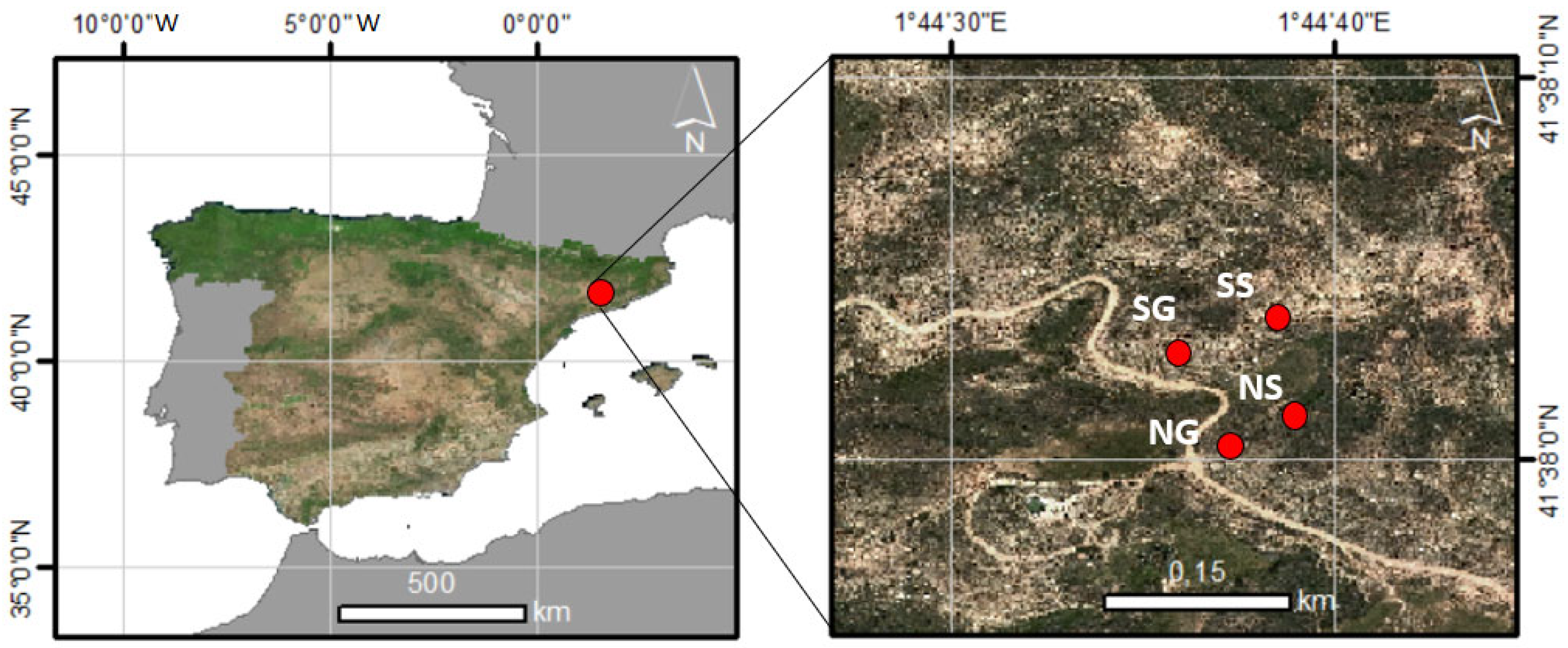
2.1. Study Area

The study area was located in Ódena (NE Iberian Peninsula) (Figure 1), in the western part of the Montserrat massif. This massif comprises a succession of conglomerates deposited during the Paleocene, Eocene, and Oligocene. These conglomerate accumulations have subsequently defined a geomorphology marked by torrential dejection cones and gully zones in the steeper areas [28]. Fragments of Palaeozoic materials crop out in the study area, basically comprising quartz schists, formed by regional metamorphism. The study area is located in a carbonated mineral context. The schist complex also contains quartz intercalations. Rounded hills, with gentle relief in their lower parts, and not exceeding 600 m in altitude, dominated the studied area of the massif; thus, slope is a key point for mineral concentration in this study area.
The predominant vegetation was composed of Pinus halepensis Miller, Pinus nigra Arnold, and Quercus ilex L., with an understory comprising Genista scopius L. and Pistacia lentiscus L. [21,28]. The mean annual temperature of the study site was 14.2 °C, with the mean annual rainfall ranging between 500 and 600 mm, according to the El Bruc meteorological gauging station (41°34′44″ N, 14°60′57″ E). The location can be classified as having a humid Mediterranean climate, characterised by a high seasonal and annual climatic variability. The precipitation regime was very irregular, with the main characteristic being torrential rainfall, a property that was taken into account in the study of the soils and their chemical, physical, and biological properties. At the study locations, the soils were generally dominated by shallowness, in many cases reaching only 40 cm deep. Soils exhibiting a lithic boundary were related to the high slopes of the higher areas. In the study area, the rounded relief and decreasing slope had allowed the soils to develop to a greater extent, and, thus, they were deeper and well drained. The soils at the study sites were classified as Fluventic Haploxerepts [29].

2.2. Methods

The study area contained four types of soil profiles—south aspect/steep slope (SS), north aspect/steep slope (NS), north aspect/gentle slope (NG), and south aspect/gentle slope (SG). Descriptions of these profiles, the horizons found in each of them, and their sedimentological characteristics are detailed in Francos et al. [8]. Each of the profiles represented different properties in terms of aspect and slope—crucial geographical properties in soil formation.
Samples were collected from different depths via profiling. The sampling methodology is described in detail in Úbeda and Sala [30]. The main characteristics of the sampling were determined by taking nearly 500 g of each sample from the different layers and packing them in a hermetic box without air and humidity; they were also based on the selection of samples from each of the horizons encountered. Due to the recurrence of forest fires in the study area, the limits of these horizons in most cases coincided with the remains of materials pyrolysed by combustion. These charred plant remains were also taken into account when sampling, with soil from 1–2 cm above and below those levels being sampled. Such samples are considered to represent recurring historical fires and related soil characteristics [31]. A similar methodology has been validated by several authors for areas of high fire recurrence, those authors having pointed out that one sample per horizon is sufficient, if enough material is sampled, for determining changes in soil characteristics with depth [32,33,34].
The soil samples were air-dried for 7 days at room temperature (23 °C), and then sieved using a 2-mm-mesh sieve in order to be able to analyse the fine soil matter (<2 mm). The extractable minor elements were determined according to the method described by Knudsen et al. [35]. The extractable Al, Mn, Fe, Zn, B, and Pb were analysed by 1:20 ammonium acetate extraction. The extractable elements were analysed by inductively coupled plasma–mass spectrometry (ICP-MS), using a Perkin Elmer Elan-6000 spectrometer and a Perkin Elmer Optima-3200 RL spectrometer. The Ca:Al ratio was calculated using the extractable Ca data from Francos et al. [8] and the extractable Al data from the present study. Both the ratio and profile figures were made using SPSS 23.0 (IBM, Armonk, NY, USA).
In order to determine the possible associations among the minor elements with soil pH for the different types of profiles, Pearson correlations were performed using the data obtained from each profile (n = 11), as well as each horizon, differentiating only horizons A, B, and C (n ≥ 4) in this case. All horizons analysed in each of the profiles showed a basic pH (between 8 and 9.5). Correlations were performed in the R environment [36] using the corrplot package [37]. Finally, a redundancy analysis (RDA) was performed to identify the relationships between the different variables, using CANOCO 4.5 software (Microcomputer Power, Ithaca, NY, USA).

3. Results

3.1. Analysis of Minor Elements by Profile and Horizon

The results for minor elements are shown in Table 1 by all soil horizons detected in the study and are summarised for the major categories of soil horizons or master horizons (A, B, and C) in Figure 2. We found decreases in the extractable Al with depth in all profiles except for SS, where a high Al concentration was recorded in the 2B horizon. There were no clear patterns for Al in relation to topography (Figure 2). The extractable Fe slightly increased with depth, but we noted that horizon 2B in the SS and NG profiles exhibited high Fe values that were much greater than those in the rest of the horizons in all the profiles. Regarding to the extractable Mn, there was a considerable increase with depth except in the SS profile, with overall higher Mn concentrations being found in the northern profiles. In the rest of the profiles, the highest extractable Mn contents were found in the C horizons. The NG profile stood out for having two horizons (C and 2C) in which high Mn contents were recorded (Table 1). The Zn concentrations did not show a consistent pattern among the studied profiles in relation to depth, although increases with depth were detected in the SS profile, and higher Zn values were generally recorded in the north-faced profiles (Figure 2). In the SG and NG profiles, the highest Zn values corresponded to the shallowest horizons and at greatest depth. The soil extractable B was higher at the surface than at depth in the SS and NS profiles, with the opposite pattern being exhibited in the gently sloping profiles except for in the lowest horizon (Table 1). The soil extractable Pb showed contrasting dynamics in terms of the aspect and slope, and there were no clear patterns in relation to these variables (Figure 2). Despite this, higher Pb contents were detected in the horizons of the soil profiles from the gentle slopes than from the steep slopes. The Ca:Al ratio showed contrasting dynamics, increasing with depth in the gentle profiles and decreasing with depth in the SS profile (Figure 2).

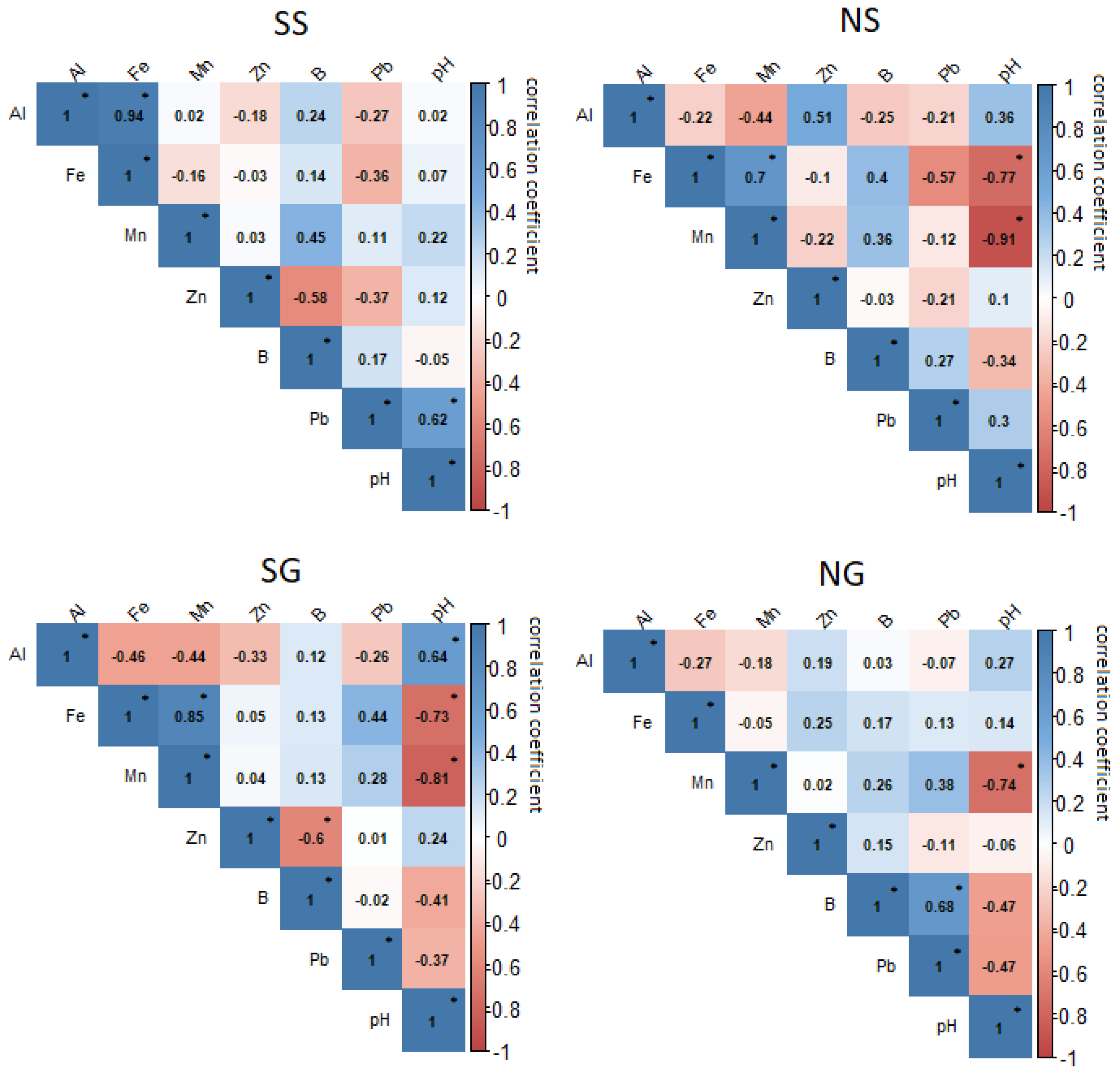
3.2. Correlation Analysis of Minor Elements by Profile

The correlation analysis revealed variable behaviours among the different soil profiles, and, in general, no common patterns between profiles with the same slope or aspect (Figure 3). A significant positive relationship was detected between Al and Fe only in the SS profile, with no statistically significant relationships being detected among the rest of the elements or in the other horizons in this profile. There was a significant positive relationship between Fe and Mn in the NS and SG profiles, and a significant negative relationship with pH in the same profiles, but with no statistically significant relationships being detected among the rest of the elements or in the rest of the horizons. In addition, we found significant negative relationships between Mn and pH in three of the profiles (NS, SG, and NG), indicating a higher concentration of this element in acidic soils, regardless of aspect or slope. An inverse relationship between Zn and B was identified in the SG profile. A similar relationship, although not significant, was also detected in the SS profile, whereas B only showed a significant relationship with Zn in the NG profile, as mentioned above. There were no significant relationships involving Pb, although a relatively strong inverse relationship was detected between Pb and Fe in the steep slope profiles, and a direct relationship in the SG profile.

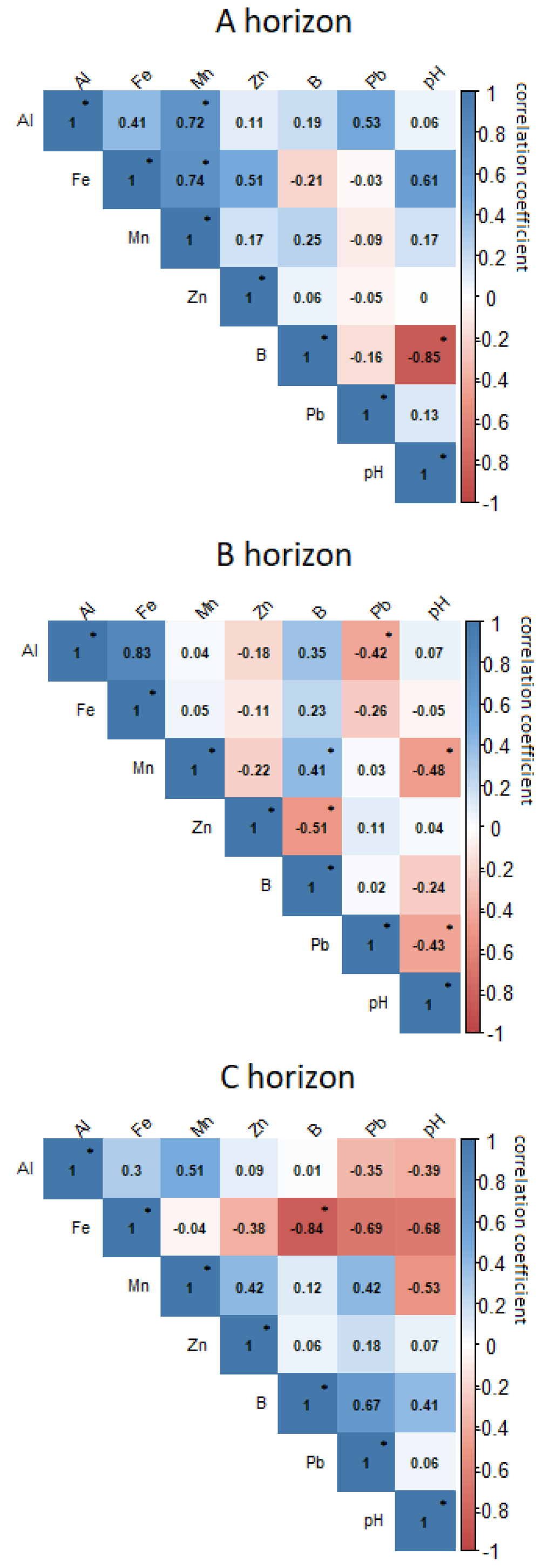
3.3. Correlation Analysis of Minor Elements by Horizon

The correlation analysis carried out by horizon indicated differences in how the minor elements were associated along the soil profiles, detecting common patterns for some of these (Figure 4). There was a positive relationship between Al and the rest of the elements and with pH in the A horizon, although we only detected a significant relationship with Mn. In the rest of the horizons, the same relationship was observed between Al and Mn. In the deepest horizons, Al was negatively related to Pb. As for the relationship between Fe and the rest of the elements, there was a significant positive relationship between it and Mn in the A horizon, but this decreased in deeper horizons. In the C horizon, Fe showed a significant inverse relationship with B. A transition in the relationship between Fe and pH with depth was also detected, this relationship being positive in the A horizon and negative in the C horizon, although these relationships were not statistically significant. Apart from its relationship with Fe, Mn had a significant positive relationship with B in the B horizon. In addition, it was noted that the higher concentrations of Mn with increased acidity applied mainly to the B and C horizons. The relationship between Zn and the rest of the elements showed a highly variable dynamic depending on the soil horizon, and only a significant (inverse) relationship of this element with B was detected. There was also a significant strong negative relationship between B and soil pH in the A horizon, although this decreased with depth in the soil profile. The relationships between Pb and the rest of the elements showed an opposite dynamic in the A horizon compared to the B and C horizons, with a significant inverse relationship between Pb and pH only being detected in the B horizon.

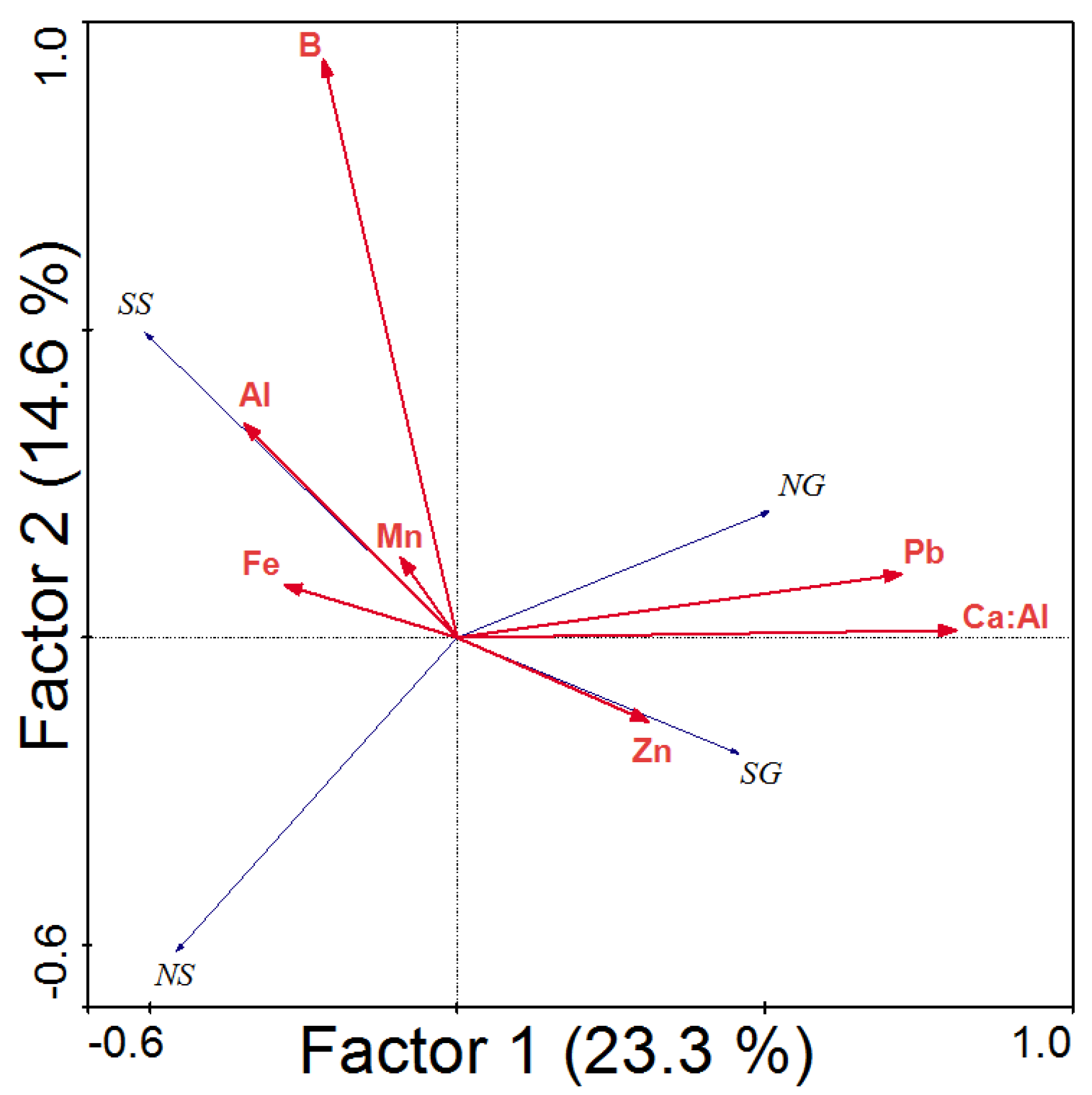
3.4. Multivariate Analysis

We supplemented the correlation analysis with an RDA in order to determine the overall relationships between the minor elements analysed and the selected profiles by ordering them according to their linear relationships in relation to ordination factors (Figure 5). Our RDA explained 37.9% of the total variance, the first factor explaining 23.3% of the sample variance and the second factor explaining 14.6%. The RDA indicated that slope was more relevant than aspect in the ordination, the profiles with gentle slopes clearly being associated and increasing towards the positive part of Factor 1, whereas the profiles with steep slopes increased towards the negative part of Factor 1. The profiles with gentle slopes (SG and NG) were linked to higher Zn, Pb, and Ca:Al ratio values. To the contrary, the steep slope profiles (SS and NS) were associated with higher values of the other extractable elements (mainly Al, Fe, and Mn).

4. Discussion

This study is complementary to Francos et al. [8] in which the most significant results were that soils in gentle slopes present higher values of organic matter, Ca and Mg, and lower values of Na than those in steep areas. In relation to aspect, inorganic C and Na are higher in the south-facing profiles, while total N and K are higher in north-facing soils. However, despite the differences observed across the studied profiles, soil inorganic C, total N, C/N, pH, electrical conductivity, and K do not vary with slope, and organic matter, C/N, pH, electrical conductivity, Ca, and Mg are not influenced by aspect.
In this work, the minor soil elements show similar trends, according to their mineral origin. The decreases in extractable Al with depth can be explained by its known inverse relationship with acidic substances, such as humic and fulvic acids from soil organic matter [38,39]. This assumption agrees with the findings of Francos et al. [8], who showed generalised increases in soil organic matter with depth in the same soil profiles we studied here. In addition, the different behaviour of Al in the SS profile might suggest a higher frequency of historical fires that may have decreased the available Al and also Fe, as previously suggested by Pereira et al. [24].
The extractable Fe in the soil increased with depth due to washing of the shallower horizons and the consequent accumulation of Fe in the deeper horizons [38]. The high Fe content in the 2B horizon of the SS profile could be related to the higher amount of Al in the same horizon of that profile. The correlation analysis corroborated the relationship between these elements not only in that case, but also in all horizons, in general. Thus, we can state that, apart from the exceptions, Fe and Al—the third and fourth most abundant elements in the Earth’s crust, respectively—follow similar dynamics with depth [23], being released by weathering of the parent rock and parent materials, and commonly increasing with soil age [40].
In the case of extractable Mn, it has been found that the zones or horizons with higher amounts of Fe tend to have low amounts of Mn [41,42]. However, our results did not support this evidence, except for in horizon 2B, which exhibited a high concentration of Fe and low Mn values. As the correlation analysis showed, in three of the four profiles studied, the more the pH decreased, the more the concentration of extractable Mn increased in soil solution, mainly due to an increase in Mn2+ because, when pH increases, the forms of Mn not available to plants, such as Mn(III) and Mn(IV), predominate [43]. Likewise, positive relationships between extractable Mn and exchangeable K, Ca, and Mg have been reported from the uppermost layers of soil [42]. As with other minor elements, Mn accumulates in the deeper horizons due to soil washing, resulting in the most superficial layers having lower Mn contents. Extractable Mn is essential for seed germination and vegetative growth, so its pattern of occurrence, together with the low Fe content in the SS profile, means that vegetation in this area is scarce [18]. This situation, observed during fieldwork, is typical in sunny areas with steep slopes where soil nutrients are scarce and moisture is limited [8]. Although high concentrations of Mn can cause toxicity in plants, the toxicity threshold is highly dependent on the plant species under consideration [43].
The maximum Zn concentrations were found in the shallowest and deepest horizons in the shallow-slope profiles. In the profiles located on steep slopes, those with a southern aspect contained higher concentrations at depth than at the surface, whereas those with a northern aspect had higher values at the surface. This contrasting dynamic may be determined by the availability of moisture in the soil and the positive link between Zn and organic matter [44]. In the case of SS, a natural dynamic was followed in terms of soil washing and Zn accumulation in deep horizons [38]. In the case of NS, the high humidity probably caused Zn to accumulate at the surface, whilst leaching of the shallower horizons was not so intense.
As for extractable B, the results showed very similar dynamics in the gently sloping areas, with no differences in the aspect of the slopes, the amount of B increasing with increasing depth and decreasing in the deepest horizon. Thus, it is clear that one of the determining factors in the distribution of B was the slope [45]. In the case of SS, the amount of B decreased as depth increased, whereas in NS, it was constant and scarce in all horizons.
The soil extractable Pb displayed contrasting dynamics in terms of aspect and slope, such that there were no clear patterns among the horizons in the profiles. What can be highlighted at a general level is the higher Pb content in all horizons in the two profiles on gentle slopes compared to those on the steep slopes. The dynamics of the extractable Pb were erratic, but there were differences in the amounts between the two slopes, with higher values (although not to the point of being contaminants) recorded in the gently sloping areas. This erratic dynamic has not always been associated with topography, but has been associated with other terrain conditions, as pointed out by Francos et al. [46].
The Ca:Al ratios indicated contrasting dynamics with respect to aspect and slope. At a general level, the higher values in the gentle-slope profiles were notable, where there was also an increasing trend with increasing depth. Contrastingly, in the steep-slope profiles, there was little to no variation between the horizons or with increasing depth, except in the case of horizon 2B in the SS profile, where the values were significantly lower than in the other horizons in this profile. In this sense, there were clear differences due to slope, but not so much due to exposure. There was also an increase in the Ca:Al ratio with depth in the gentle-slope profiles. Pereira et al. [24] and Francos et al. [21] have pointed out that fire has an ephemeral impact on Ca:Al ratios and, with the passage of time in areas where neither erosion nor degradation has occurred, their values can increase. This may have been the case in our shallow-slope profiles, where the Ca:Al ratios increased with increasing depth, possibly signifying the recovery and enrichment of these horizons. The Ca:Al ratio in soil is used as an indicator of the onset of forest damage, this aspect being of importance to the health and vitality of forest stands or even forest survival and, in the long term, forest productivity [47]. For the steep-sloped profiles, no erosion marks or signs of erosion were recorded, but it is possible that the steepness may have prevented the enrichment of the deep horizons. Some authors have concluded that higher Ca:Al ratios are common in areas with more fertile soils (e.g., Cornelissen et al. [48]). Other authors, such as Xiang et al. [49], have related increases in Ca:Al ratios to reduced soil contamination by heavy metals, such as Pb, due to the infilling of micropores during soil formation. This suggests that the low-slope areas in our study should have had high Ca:Al ratios and Pb; however, the values obtained indicate that the soil was not contaminated with heavy metals and was very fertile. We did not find Ca:Al ratios that fell below the Al stress threshold (<1) [50] in any of the horizons of any profile, so there was no risk of Al stress to plants in the study area. No previous studies have focused on how various topographic variables, such as exposure and slope, affect the Ca:Al ratio, and so the results we obtained are highly relevant for determining the dynamics followed by the soil at different depths in each of the profiles.
In general, the accumulation of heavy metals is closely linked to the local lithology [51]. In our case, carbonate elements prevailed throughout the study area, the absorption of minor elements, such as Pb, B and Zn, being associated with the fixation of carbonates. These carbonates have acted as fixers of the minor metals in our profiles, so they do not cause damage to vegetation or crops. Thus, no bioremediation measures, beyond those specific to improving the soil quality, are necessary. The analysis of minor elements is very important because, for example, a lower amount of extractable B can result in low plant regrowth and toxicity in the soil, so it is essential to control the amount of B in the most critical areas, such as those with steep slopes [52].
In two of the profiles analysed, slope was a key element in potential soil loss. At times of high rainfall intensities, runoff can cause soil and material losses of up to 15% in areas with steep slopes [53]. Some erosion mitigation measures could be employed to lessen such erosion—extensive cattle ranching could be a good mitigating measure according to some researchers [33]. Topographic conditions, in addition to vegetation cover, are fundamental factors in determining the erosive power and potential environmental degradation of a particular area [54]. Vegetation and other factors, such as torrential post-fire rains or forest management practices [17], can increase the capacity of an area to be eroded through increased energy [55], and this must be taken into account when assessing the potential degradation of an area. Therefore, it is essential to determine the chemical characteristics of the soil, for evaluating whether restoration measures are needed to preserve soil functionality [46].
The soil system is becoming increasingly recognised as important in the fight against climate change, particularly from the point of view of carbon storage. Some authors have suggested that the long-term effects of climate change can be minimised through soil management, forestry, and agricultural activities [56]. Such management is not only essential in addressing the impact that various external disturbances exert on soil, but also in maintaining soil functions that can be compromised due to the edaphic properties that are affected [57]. The soil degradation that can follow wildfire can accelerate decarbonisation processes in affected areas [58]. In that case, management could involve reforestation to alleviate soil degradation. Other areas of the Montserrat massif are being managed through a selective reforestation plan, and also the addition of livestock to clear the undergrowth and reduce the risk of wildfires (https://lifemontserrat.eu/ [accessed 21 February 2022]).
Soil fertility is indirectly related to soil degradation, but erosion management will help the soil to contribute to the mitigation of carbon-stock loss [58]. In addition, minor elements, such as Fe and Al, are indicators of nitrite and nitrate uptake, as they facilitate the uptake of these nutrients by the tree species found in the study area [59]. Furthermore, with the incorporation of certain tree species as a mitigation measure, soil loss due to runoff in times of torrential rainfall could be decreased [60], and nutrients would be better conserved in the soil in areas with both steep and shallow slopes and in areas with different aspects [8]. Thus, controlling the carbon stock through setting different species, and introducing livestock for post- and pre-fire management, would allow it to work in a broader framework with respect to large forest fires. According to Fairman et al. [61], the carbon stock is altered after two large wildfires. In the study area, two large wildfires have occurred in the last 30 years (1986–2015). With appropriate management of the land, preventive measures can preserve soil quality, help in accumulating some of the minor elements and, in relation to climate change, increase carbon stocks [8]. In addition, mountain systems provide a large number of ecosystem services, such as food, energy (wind and solar), and cultural and social services [62]. Rural abandonment and an increase in forest mass, in the absence of management, may have resulted in a greater severity of the fires in the study area [17]. Through qualitative evaluation and recognising the importance of the western area of the Montserrat massif to local ecosystem services, it may be possible to apply pre-fire management over the coming decades to prevent the area from experiencing more forest fires.

5. Conclusions/Final Remarks

The combined or joint action of aspect, slope, soil profile depth, and other environmental factors such as fire, climate, or human activity plays a highly relevant role in soil minor elements and is key to understand the dynamics of the spatial manifestation of soil chemical properties and their variations.
The foregoing is reflected in specific findings from our study, such as how the patterns of the minor elements are strongly linked to parent-rock lithology, but also, in this fire-prone environment, to pedological variables, and topographical variables, such as aspect and slope and their interaction. Thus, we have revealed that in an area historically affected by frequent fires, Fe and Mn increased with depth while Al decreased with little influence of slope and aspect. However, B increased with depth in the shallow-slope profiles, whereas it increased with depth on the steep slopes. Pb peaked in gentle slopes, with contrasting patterns across the soil profile depending on aspect, and Mn and Zn were high mainly in the profiles exposed to the north.
In view of our findings, which point to a permanent interrelationship between minor soil chemical elements and environmental factors in an area historically affected by forest fires, it is important to acknowledge the importance of complementary future scientific contributions, including the analysis of locations at different latitudes under different environmental conditions. This work has contributed to the knowledge base towards establishing better management practices for areas affected by fire. Moreover, we state that it is necessary to incorporate the findings of this type of study, in which geographical/topographical variables, such as slope and aspect, are assessed, in forest management plans in order to determine the areas where post-fire amendments are necessary, thus avoiding soil degradation.

Author Contributions

Conceptualization, M.F. and C.S.-G.; methodology, M.F., C.S.-G., and V.F.-G.; software, M.F., V.F.-G., and O.C-G; validation, M.F., C.S.-G., and V.F-G; formal analysis, M.F., C.S.-G., and O.C.-G.; investigation, M.F., C.S.-G., V.F.-G., and O.C.-G.; resources, M.F. and C.S.-G.; data curation, M.F. and C.S.-G.; writing—original draft preparation, M.F., C.S.-G., V.F.-G., and O.C.-G.; writing—review and editing, M.F., C.S.-G., V.F.-G., and O.C.-G.; visualization, C.S.-G. and O.C.-G.; supervision, M.F. and V.F.-G.; project administration, M.F. and C.S-G; funding acquisition, M.F. All authors have read and agreed to the published version of the manuscript.

Funding

This research was funded by MCIN/AEI/10.13039/501100011033 and ERDF “A way of making Europe”, grant number PID2021-126946OB-I00. The Margarita Salas Postdoctoral Fellowship allowed us to develop the study.

Data Availability Statement

Not applicable.

Acknowledgments

The authors would like to thank J. Lees and C. Leslie for their support for language revision.

Conflicts of Interest

The authors declare no conflict of interest.

References

  1. Jenny, H. The Soil Resource: Origin and Dynamic; Springer Science and Business Media: Berlin/Heidelberg, Germany, 2012; p. 376. [Google Scholar]
  2. Van der Knijff, J.M.; Jones, R.J.A.; Montanarella, L. Soil Erosion Risk Assessment in Europe; European Soil Bureau: Brussels, Luxembourg, 2000. [Google Scholar]
  3. Przepióra, P.; Król, G.; Fraczek, M.; Kalicki, T.; Klusakiewic, E. Location and interpretation of post-forest-fire sediments—Case studies. Folia Geogr. Phys. 2017, 16, 43–49. [Google Scholar]
  4. Sánchez-García, C.; Schulte, L.; Carvalho, F.; Peña, J.C. A 500-year flood history of the arid environments of southeastern Spain. The case of the Almanzora River. Glob. Planet. Change 2019, 181, 102987. [Google Scholar] [CrossRef]
  5. Fernández-García, V.; Beltrán-Marcos, D.; Fernández-Guisuraga, J.M.; Marcos, E.; Calvo, L. Predicting potential wildfire severity across Southern Europe with global data sources. Sci. Total Environ. 2022, 829, 154729. [Google Scholar] [CrossRef]
  6. Úbeda, X.; Mataix-Solera, J.; Francos, M.; Farguell, J. Grandes incendios forestales en España y alteraciones de su régimen en las últimas décadas. In Geografia, Riscos e Proteção Civil. Homenagem ao Professor doutor Luciano Lourenço; Nunes, A., Amaro, A., Vieira, A., Velez de Castro, F., Felix, Eds.; F. RISCOS—Associação Portuguesa de Riscos, Prevenção e Segurança: Coimbra, Portugal, 2021; Volume 2. [Google Scholar]
  7. Certini, G. Fire as a Soil-Forming Factor. Ambio 2013, 43, 191–195. [Google Scholar] [CrossRef] [Green Version]
  8. Francos, M.; Sánchez-García, C.; Girona-García, A.; Fernández-García, V. Influence of topography on sediment dynamics and soil chemical properties in a Mediterranean forest historically affected by wildfires: NE Iberian Peninsula. Environ. Earth Sci. 2021, 80, 436. [Google Scholar] [CrossRef]
  9. Armstrong, A.; Quinton, J.; Francis, B.; Heng, B.; Sander, G. Controls over nutrient dynamics in overland flows on slopes representative of agricultural land in North West Europe. Geoderma 2011, 164, 2–10. [Google Scholar] [CrossRef]
  10. Parente, J.; Girona-García, A.; Lopes, A.R.; Keizer, J.J.; Vieira, D.C.S. Prediction, validation, and uncertainties of a nation-wide post-fire soil erosion risk assessment in Portugal. Sci. Rep. 2022, 12, 2945. [Google Scholar] [CrossRef]
  11. Osborne, B.B.; Nasto, M.K.; Asner, G.P.; Balzotti, C.S.; Cleveland, C.C.; Sullivan, B.W.; Taylor, P.G.; Townsend, A.R.; Porder, S. Climate, Topography, and Canopy Chemistry Exert Hierarchical Control Over Soil N Cycling in a Neotropical Lowland Forest. Ecosystems 2017, 20, 1089–1103. [Google Scholar] [CrossRef]
  12. Jendoubi, D.; Liniger, H.; Speranza, C.I. Impacts of land use and topography on soil organic carbon in a Mediterranean landscape (north-western Tunisia). Soil 2019, 5, 239–251. [Google Scholar] [CrossRef] [Green Version]
  13. Certini, G. Effects of fire on properties of forest soils: A review. Oecologia 2005, 143, 1–10. [Google Scholar] [CrossRef]
  14. Santín, C.; Doerr, S.H. Fire effects on soils: The human dimension. Philos. Trans. R. Soc. B Biol. Sci. 2016, 371, 20150171. [Google Scholar] [CrossRef]
  15. Fernández-García, V.; Marcos, E.; Fernández-Guisuraga, J.M.; Taboada, A.; Suárez-Seoane, S.; Calvo, L. Impact of burn severity on soil properties in a Pinus pinaster ecosystem immediately after fire. Int. J. Wildland Fire 2019, 28, 354–364. [Google Scholar] [CrossRef]
  16. Fernández-García, V.; Miesel, J.; Baeza, M.J.; Marcos, E.; Calvo, L. Wildfire effects on soil properties in fire-prone pine ecosystems: Indicators of burn severity legacy over the medium term after fire. Appl. Soil Ecol. 2018, 135, 147–156. [Google Scholar] [CrossRef] [Green Version]
  17. Francos, M.; Úbeda, X.; Pereira, P. Impact of torrential rainfall and salvage logging on post-wildfire soil properties in NE Iberian Peninsula. Catena 2019, 177, 210–218. [Google Scholar] [CrossRef]
  18. Garciamarco, S.; Gonzalez-Prieto, S. Short- and medium-term effects of fire and fire-fighting chemicals on soil micronutrient availability. Sci. Total Environ. 2008, 407, 297–303. [Google Scholar] [CrossRef] [Green Version]
  19. Quigley, K.M.; Wildt, R.E.; Sturtevant, B.R.; Kolka, R.K.; Dickinson, M.B.; Kern, C.C.; Donner, D.M.; Miesel, J.R. Fuels, vegetation, and prescribed fire dynamics influence ash production and characteristics in a diverse landscape under active pine barrens restoration. Fire Ecol. 2019, 15, 5. [Google Scholar] [CrossRef]
  20. Jovanovic, V.P.S.; Ilic, M.D.; Markovic, M.S.; Mitic, V.D.; Nikolic Mandic, S.D.; Stojanovic, G.S. Wild fire impact on copper, zinc, lead and cadmium distribution in soil and relation with abundance in selected plants of Lamiaceae family from Vidlic Mountain (Serbia). Chemosphere 2011, 84, 1584–1591. [Google Scholar] [CrossRef]
  21. Francos, M.; Úbeda, X.; Pereira, P. Long-term forest management after wildfire (Catalonia, NE Iberian Peninsula). J. For. Res. 2020, 31, 269–278. [Google Scholar] [CrossRef]
  22. Johnson, D.W.; Walker, R.F.; McNulty, M.; Rau, B.M.; Miller, W.W. The Long-Term Effects of Wildfire and Post-Fire Vegetation on Sierra Nevada Forest Soils. Forests 2012, 3, 398–416. [Google Scholar] [CrossRef] [Green Version]
  23. Francos, M.; Úbeda, X.; Pereira, P. Impact of bonfires on soil properties in an urban park in Vilnius (Lithuania). Environ. Res. 2020, 181, 108895. [Google Scholar] [CrossRef]
  24. Pereira, P.; Cerda, A.; Martin, D.; Úbeda, X.; Depellegrin, D.; Novara, A.; Martínez-Murillo, J.F.; Brevik, E.C.; Menshov, O.; Comino, J.R.; et al. Short-term low-severity spring grassland fire impacts on soil extractable elements and soil ratios in Lithuania. Sci. Total Environ. 2017, 578, 469–475. [Google Scholar] [CrossRef]
  25. Francos, M.; Úbeda, X.; Pereira, P.; Alcañiz, M. Long-term impact of wildfire on soils exposed to different fire severities. A case study in Cadiretes Massif (NE Iberian Peninsula). Sci. Total Environ. 2018, 615, 664–671. [Google Scholar] [CrossRef]
  26. Campo, J.; Lorenzo, M.; Cammeraat, E.L.; Picó, Y.; Andreu, V. Emerging contaminants related to the occurrence of forest fires in the Spanish Mediterranean. Sci. Total Environ. 2017, 603, 330–339. [Google Scholar] [CrossRef]
  27. Walker, X.J.; Baltzer, J.L.; Cumming, S.G.; Day, N.J.; Ebert, C.; Goetz, S.; Johnstone, J.F.; Potter, S.; Rogers, B.M.; Schuur, E.A.G.; et al. Increasing wildfires threaten historic carbon sink of boreal forest soils. Nature 2019, 572, 520–523. [Google Scholar] [CrossRef]
  28. Panareda-Clopés, J.M.; Nuet-Badia, J. Tipología y cartografía corológica de las plantas vasculares de Montserrat (Cordillera Prelitoral Catalana). Rev. Geogr. 1993, 27, 33–58. [Google Scholar]
  29. Soil Survey Staff. Keys to Soil Taxonomy; USDA-Natural Resources Conservation Service: Washington, DC, USA, 2014.
  30. Úbeda, X.; Sala, M. Guia Pràctica per a L’estudi Dels Sols; Publicaciones Universitat de Barcelona: Barcelona, Spain, 1995. [Google Scholar]
  31. Conedera, M.; Tinner, W.; Neff, C.; Meurer, M.; Dickens, A.; Krebs, P. Reconstructing past fire regimes: Methods, applications, and relevance to fire management and conservation. Quat. Sci. Rev. 2009, 28, 555–576. [Google Scholar] [CrossRef]
  32. Yulianto, E.; Hirakawa, K.; Tsuji, H. Charcoal and organic geochemical properties as an evidence of Holocene fires in tropical peatland, Central Kalimantan, Indonesia. Tropics 2004, 14, 55–63. [Google Scholar] [CrossRef] [Green Version]
  33. Blake, W.H.; Kelly, C.; Wynants, M.; Patrick, A.; Lewin, S.; Lawson, J.; Nasolwa, E.; Page, A.; Nasseri, M.; Marks, C.; et al. Integrating land-water-people connectivity concepts across disciplines for co-design of soil erosion solutions. Land Degrad. Dev. 2020, 32, 3415–3430. [Google Scholar] [CrossRef]
  34. Armas-Herrera, C.M.; Pérez-Lambán, F.; Badía-Villas, D.; Peña-Monné, J.L.; González-Pérez, J.A.; Millán, J.V.P.; Jiménez-Morillo, N.T.; Sampietro-Vattuone, M.M.; Gracia, M.A. Pyrogenic organic matter from palaeo-fires during the Holocene: A case study in a sequence of buried soils at the Central Ebro Basin (NE Spain). J. Environ. Manag. 2018, 241, 558–566. [Google Scholar] [CrossRef] [Green Version]
  35. Knudsen, D.; Peterson, G.A.; Pratt, P.F. Lithium, sodium, and potassium. In Methods of Soil Analysis: Part 2 Chemical and Microbiological Properties; Page, A.L., Ed.; Agronomy Monographs: Madison, WI, USA, 1983; pp. 225–246. [Google Scholar]
  36. R Core Team. R: A Language and Environment for Statistical Computing. Available online: https://www.R-project.org/ (accessed on 20 July 2022).
  37. Taiyun, W.; Viliam, S. R Package “Corrplot”: Visualization of a Correlation Matrix. Version 0.84. 2017. Available online: https://github.com/taiyun/corrplot (accessed on 20 July 2022).
  38. Hempfling, R.; Schulten, H.-R. Chemical characterization of the organic matter in forest soils by Curie point pyrolysis-GC/MS and pyrolysis-field ionization mass spectrometry. Org. Geochem. 1990, 15, 131–145. [Google Scholar] [CrossRef]
  39. Whitley, A.; Moir, J.; Almond, P.; Moot, D. Soil pH and exchangeable aluminium in contrasting New Zealand high and hill country soils. NZGA Res. Pr. Ser. 2016, 16, 169–172. [Google Scholar] [CrossRef]
  40. Watham, L.; Sarangthem, I.; Sharla, L.D.; Athokpam, H.S. Distribution of different forms of iron (Fe) and aluminium (Al) under different land use system in acid soil. Pharma Innov. J. 2019, 8, 1–4. [Google Scholar]
  41. Jones, J.B. Agronomic Handbook: Management of Crops, Soils and Their Fertility; CRC Press: Boca Raton, FL, USA, 2003. [Google Scholar]
  42. Behera, S.K.; Shukla, A.K. Total and Extractable Manganese and Iron in Some Cultivated Acid Soils of India: Status, Distribution and Relationship with Some Soil Properties. Pedosphere 2014, 24, 196–208. [Google Scholar] [CrossRef]
  43. Millaleo, R.; Diaz, M.R.; Ivanov, A.; Mora, M.; Alberdi, M. Manganese as Essential and Toxic Element for Plants: Transport, Accumulation and Resistance Mechanisms. J. Soil Sci. Plant Nutr. 2010, 10, 470–481. [Google Scholar] [CrossRef] [Green Version]
  44. Marañón-Jiménez, S.; Castro, J.; Fernández-Ondoño, E.; Zamora, R. Charred wood remaining after a wildfire as a reservoir of macro- and micronutrients in a Mediterranean pine forest. Int. J. Wildland Fire 2013, 22, 681–695. [Google Scholar] [CrossRef] [Green Version]
  45. Zhang, X.; Li, M.-J.; Zhan, L.-Q.; Wu, W.; Liu, H.-B. Boron availability in top- and sub-soils as affected by topography and climate. Nutr. Cycl. Agroecosystems 2020, 118, 91–101. [Google Scholar] [CrossRef]
  46. Francos, N.; Gholizadeh, A.; Ben Dor, E. Spatial distribution of lead (Pb) in soil: A case study in a contaminated area of the Czech Republic. Geomatics, Nat. Hazards Risk 2022, 13, 610–620. [Google Scholar] [CrossRef]
  47. Sverdrup, H.; Warfvinge, P.; Rosen, K.A.J. A model for the impact of soil solution Ca: Al ratio, soil moisture and temperature on tree base cation uptake. Water Air Soil Pollut. 1992, 61, 365–383. [Google Scholar] [CrossRef]
  48. Cornelissen, G.; Nurida, N.L.; Hale, S.E.; Martinsen, V.; Silvani, L.; Mulder, J. Fading positive effect of biochar on crop yield and soil acidity during five growth seasons in an Indonesian Ultisol. Sci. Total Environ. 2018, 634, 561–568. [Google Scholar] [CrossRef]
  49. Xiang, L.; Zhu, H.; Zhou, R. Effect of Ca/Al Ratio on Stabilization/Solidification of Lead-Contaminated Soil by Ettringite. Adv. Civ. Eng. 2018, 2018, 3612962. [Google Scholar] [CrossRef]
  50. Levia, D.F.; Shiklomanov, A.N.; Van Stan, J.T.; Scheick, C.E.; Inamdar, S.P.; Mitchell, M.J.; McHale, P.J. Calcium and aluminum cycling in a temperate broadleaved deciduous forest of the eastern USA: Relative impacts of tree species, canopy state, and flux type. Environ. Monit. Assess. 2015, 187, 458. [Google Scholar] [CrossRef] [PubMed]
  51. Schulte, L. Evolución Cuaternaria de la Depresión de Vera y de Sorbas Oriental. SE Península Ibérica: Reconstrucción de las Fluctuaciones Paleoclimáticas a Partir de Estudios Morfológicos y Edafológicos; Publicaciones de la Universidad de Barcelona: Barcelona, Spain, 2002; p. 252. [Google Scholar]
  52. Arora, S.; Chahal, D.S. Effect of Soil Properties on Boron Adsorption and Release in Arid and Semi-Arid Benchmark Soils. Commun. Soil Sci. Plant Anal. 2010, 41, 2532–2544. [Google Scholar] [CrossRef]
  53. Kratzert, F.; Klotz, D.; Brenner, C.; Schulz, K.; Herrnegger, M. Rainfall–runoff modelling using Long Short-Term Memory (LSTM) networks. Hydrol. Earth Syst. Sci. 2018, 22, 6005–6022. [Google Scholar] [CrossRef]
  54. Ochoa, P.; Fries, A.; Mejía, D.; Burneo, J.; Ruíz-Sinoga, J.; Cerdà, A. Effects of climate, land cover and topography on soil erosion risk in a semiarid basin of the Andes. Catena 2016, 140, 31–42. [Google Scholar] [CrossRef]
  55. Stefanuto, E.B.; Lupinacci, C.M.; Carvalho, F.; Francos, M.; Úbeda, X. An evaluation of erosion in cuesta relief: São Paulo State, Brazil. Geomorphology 2022, 398, 108049. [Google Scholar] [CrossRef]
  56. Lal, R. Climate Change and Soil Degradation Mitigation by Sustainable Management of Soils and Other Natural Resources. Agric. Res. 2012, 1, 199–212. [Google Scholar] [CrossRef] [Green Version]
  57. Baraja, A.; Olivares, D.L.; Cerón-González, A. El estudio de los suelos. Un camino recorrido desde lo agronómico a lo ambiental. In Historia Ambiental de América Latina. Enfoques, Procedimientos y Cotidianidades; Urquijo, P.S., Lazos, A.E., Lefebvre, K., Eds.; Universidad Nacional Autónoma de México: Mexico City, Mexico, 2022; pp. 417–434. [Google Scholar]
  58. Ruiz-Peinado, R.; Bravo-Oviedo, A.; López-Senespleda, E.; Bravo, F.; del Rio, M. Forest management and carbon sequestration in the Mediterranean region: A review. For. Syst. 2017, 26, eR04S. [Google Scholar] [CrossRef]
  59. Kome, G.K.; Enang, R.K.; Tabi, F.O.; Yerima, B.P.K. Influence of Clay Minerals on Some Soil Fertility Attributes: A Review. Open J. Soil Sci. 2019, 9, 155–188. [Google Scholar] [CrossRef] [Green Version]
  60. Badía-Villas, D.; Esteban-Piñeiro, J.; Girona-García, A.; Ortiz-Perpiñá, O.; Poch, R. Topsoil microstructure changes after a shrubland prescribed burn (Central Pyrenees, NE Spain). Sci. Total Environ. 2020, 748, 141253. [Google Scholar] [CrossRef]
  61. Fairman, T.A.; Nitschke, C.R.; Bennett, L.T. Carbon stocks and stability are diminished by short-interval wildfires in fire-tolerant eucalypt forests. For. Ecol. Manag. 2021, 505, 119919. [Google Scholar] [CrossRef]
  62. Pereira, P.; Ignacio, M.; Bogunivic, I.; Francos, M.; Barceló, D.; Zhao, W. Ecosystem services in mountain environments: Benefits and threats. Pirin. Rev. Ecol. Montaña 2022, 177, e068. [Google Scholar] [CrossRef]
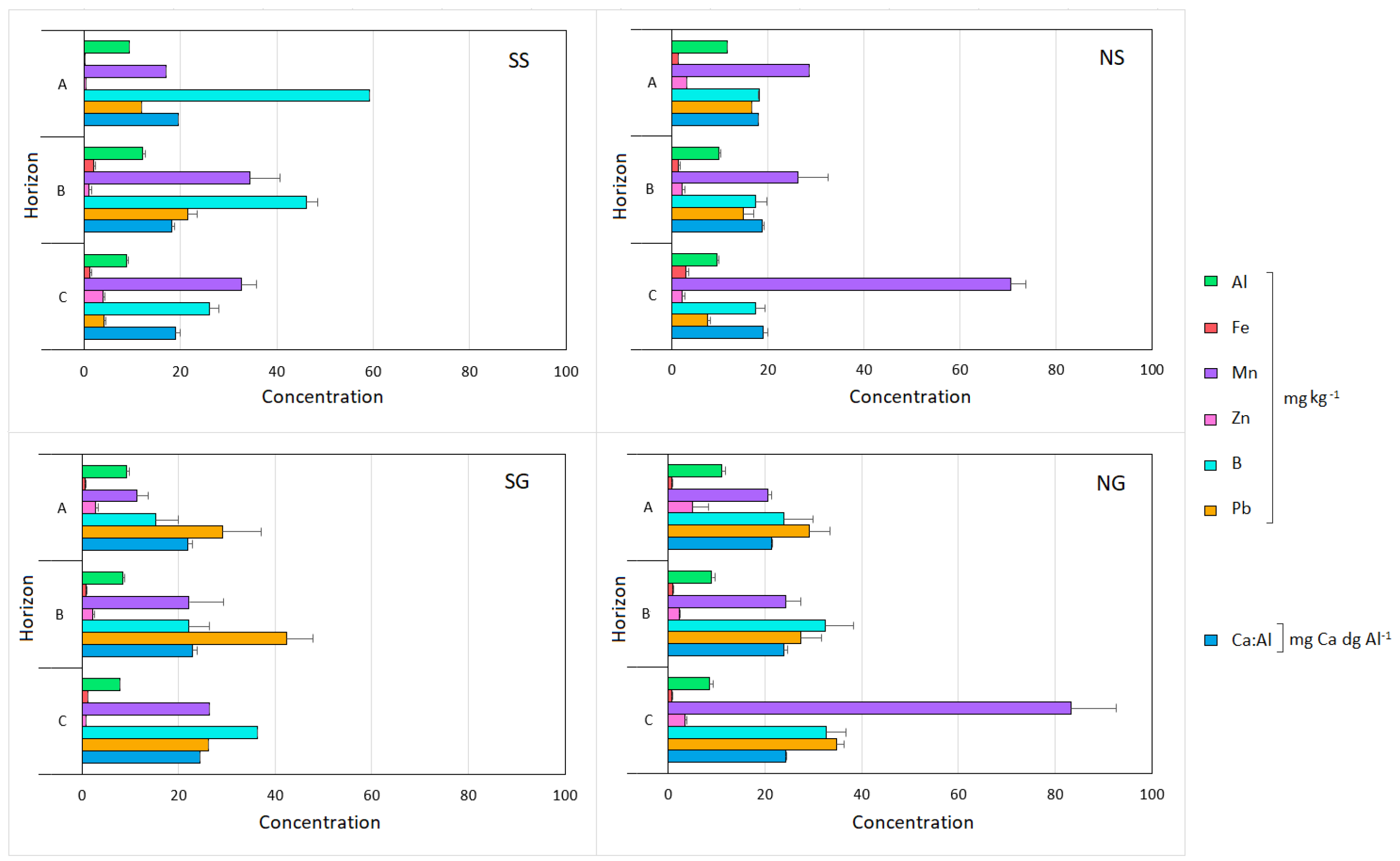
Figure 1. Location of the studied soil profiles in the Iberian Peninsula. SS–south aspect/steep slope; NS–north aspect/steep slope; NG–north aspect/gentle slope; SG–south aspect/gentle slope.
Fire 05 00189 g001
Figure 2. Mean concentration ± standard error of the minor soil elements summarised for the different master horizons (A, B, and C) of the analysed soil profiles (SS, NS, SG, and NG).
Fire 05 00189 g002
Figure 3. Correlation matrices for the different minor elements and pH, analysed by profile (SS, NS, SG, and NG). The values in the matrices are the Pearson correlation coefficients, calculated from the 11 soil characteristics obtained from each profile. Red cells—negative relationships; blue cells—positive correlations; asterisks—statistically significant correlations (p < 0.05).
Fire 05 00189 g003
Figure 4. Correlation matrices for the different minor elements and pH analysed by master horizon (A, B, and C). The values in the matrices are the Pearson correlation coefficients, calculated from the 11 soil characteristics obtained from each profile. Red cells–negative relationships; blue cells–positive correlations; asterisks–statistically significant correlations (p < 0.05).
Fire 05 00189 g004
Figure 5. RDA plot showing the relationships between the extractable minor elements in the studied soil profiles.
Fire 05 00189 g005
Table 1. Mean concentration of the minor soil elements in different studied horizons of the analysed soil profiles (SS, NS, SG, and NG). Al, Fe, Mn, Zn, B, and Pb are expressed in mg kg-1, and Ca:Al in mg Ca dg Al-1.Profile.
HorizonAlFeMnZnBPbCa:Al
SSA9.430.2217.040.3859.2711.9119.59
Bt10.700.5237.780.8844.4123.3419.70
2B15.095.1527.691.1649.4517.7315.38
C8.831.1432.573.9125.994.0918.95
NSA11.531.3228.643.1618.1116.6218.08
Bt9.751.4126.202.2117.4514.9518.70
C9.332.9870.612.1917.357.4818.99
SGA9.230.5511.432.7215.3429.0621.97
B8.930.5211.202.0519.4934.0122.01
2B7.790.9722.332.2829.6256.4923.73
C7.941.2326.400.7536.3126.2724.50
3B7.641.8665.822.6517.7247.6724.88
NGA11.040.8220.555.0523.8529.0921.30
B8.870.6430.022.4327.8926.3323.53
C8.610.6380.002.9033.6932.9624.46
2B7.921.9031.982.3148.1338.6025.93
2C8.511.0390.104.6130.7838.4524.05
Publisher’s Note: MDPI stays neutral with regard to jurisdictional claims in published maps and institutional affiliations.

