1. Introduction
Salinization is a serious challenge for the development of modern agriculture and the preservation of environment. Globally, over one fifth of the total irrigated land is salt-effected [
1]. This area could increase to above 50% in the next 30 years [
2]. Human induced or secondary salinization, such as the use of water with high salt content, super-irrigation and/or lack of drainage systems, in addition to excess fertilizer [
3,
4], instigates the accumulation of soluble salts.
In Morocco, about 16% of irrigated lands are affected by secondary salinization [
5]. In order to analyze the state of soil degradation due to salinity and evaluate the risk of its extension and aggravation, several spatio-temporal monitoring approaches have been developed and applied worldwide. The use of models allows the control of salinity by knowing its spatial distribution and its evolution over time [
6,
7]. However, monitoring the process and mapping the soil salinity are not carried out with sufficient reliability without the integration of several factors [
8]. Given the complexity of the mechanism controlling soil salinity, the use of a multicriteria approach makes it possible to identify areas at high risk of salinity and ensure the spatiotemporal monitoring of chemical soil degradation [
9]. In this context the Soil Salinity Risk Index (SSRI), which uses several factors (soil type and bedrock, climate and water table level) has been adopted for mapping soil salinity risk. This approach allows the development of a soil salinity risk map that can be used as a tool for decision-making to manage soil quality.
2. Material and Methods
2.1. Study Area
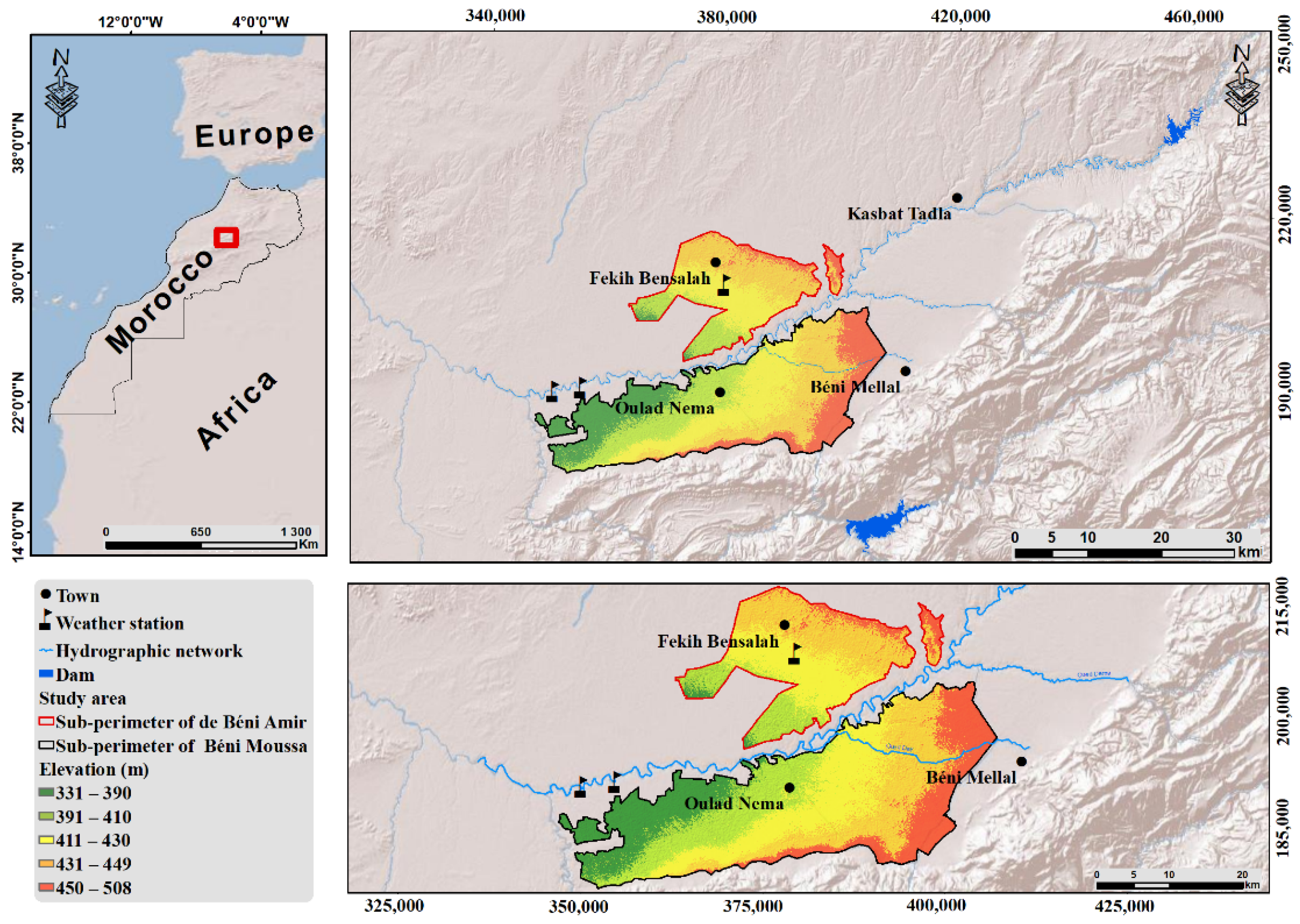
This study has been carried out in the irrigated perimeter of Tadla in central Morocco as presented in
Figure 1. Geologically, the Tadla perimeter is characterized by a vast synclinal depression filled with Neogene (Miocene and Pliocene) and Quaternary deposits [
10]. Soils studies carried out in thise area show the predominance of chromic Kastanozems soils [
11]. The climate is arid to semi-arid with average annual temperature of about 17 °C. Mean annual rainfall varies from 200 to 600 mm during 2001–2014 [
12].
2.2. Soil Salinization Risk Index (SSRI)
The SSRI is an additive method [
12,
13], which includes 9 factors; surface water and groundwater quality, depth of groundwater, climate, aridity index, slope, texture, soil electrical conductivity and geological efficiency. The SSRI calculation is based on a 5 × 9 matrix with 2 weights (1 and 2). The computation of SSRI is based on the following equation:
The risk class index for each factor is multiplied by its respective weight. The weighted values for each factor are added together to estimate SSRI, which ranges from 10 “very low” to 50 “very high” depending on the risk class as shown in
Table 1.
2.3. Data Processing
The data used in this study come from soil and water quality monitoring net-works, established by the Tadla Agricultural Development Office. The IDW (Inverse Distance Weighting) module was used to interpolate the data from 2015–2016 growing season, including water table depth, electrical conductivity of groundwater and electrical conductivity of soil. The digital Elevation Model (DEM) has been generated from digitized contour lines of the Tadla topographic map (1/50,000).
3. Results and Discussion
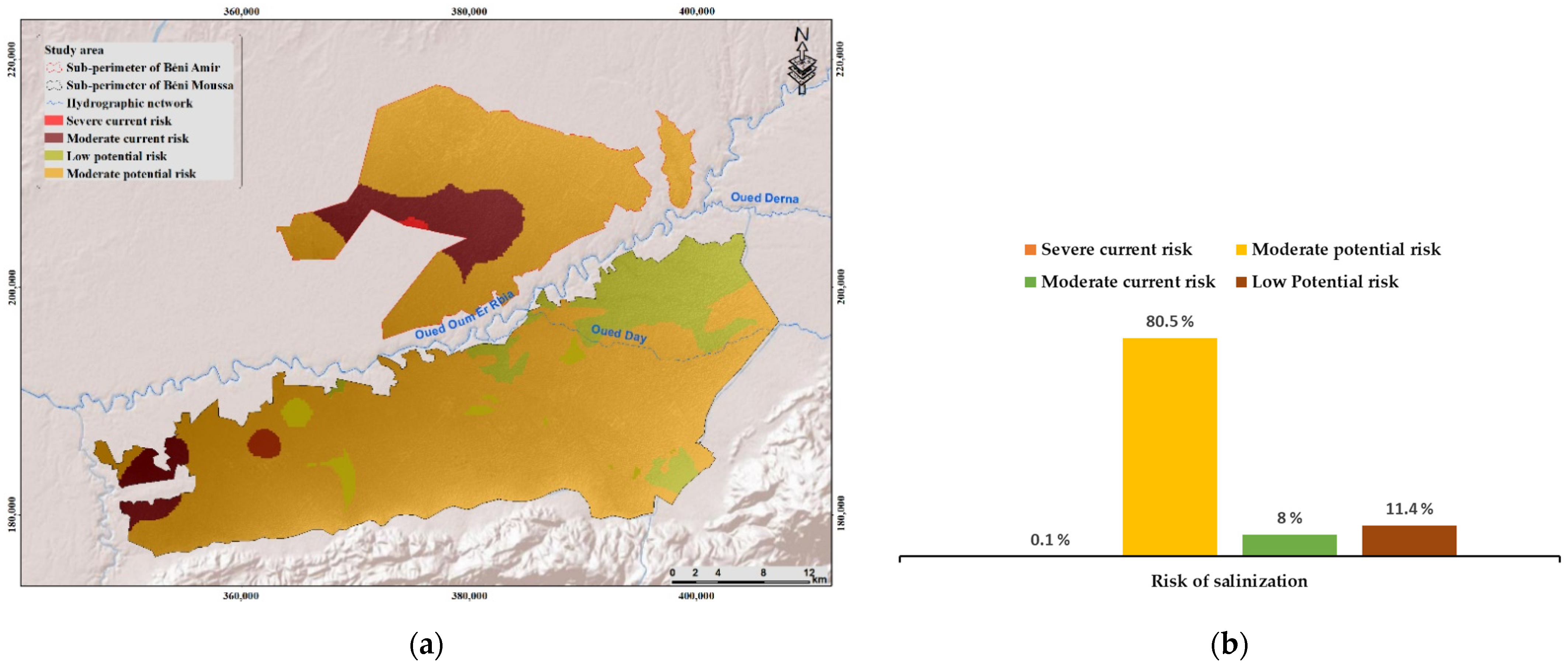
The soil salinization risk map depicted in
Figure 2a illustrates the spatial dis-tribution of salinity risk in the Tadla plain using SSRI. This approach allowed us to identify different various levels of current and potential risks by integrating the key factors influ-encing the salts accumulation process in the study area. The results showed on one hand the predominance of moderate potential risk class with an extent of 80%. This area includes soils that are very sensitive to salinity. On the other hand, area with severe risk class represents only 0.1% of the total surface of the irrigated perimeter of Tadla as shown in
Figure 2b.
The Tadla plain is divided into two sub-perimeters, Béni Amir and Béni Moussa, with different hydraulic characteristics. The Béni Amir sub-perimeter is irrigated with Oued Oum Er Rbia River, classified as saline waters, while the Béni Moussa is irrigated by the non-saline waters of Bin El Ouidane dam. Furthermore, the groundwater of Béni Amir is more saline than that of Béni Moussa. Moreover, Beni Amir is characterized by an agricultural intensification accompanied by an overuse of groundwater. In addition, the use of a gravity-fed irrigation system and the absence of drainage favor the process of soil salinity. In the Béni Moussa perimeter, the installation of drip system and the irrigation with non-saline water decrease salt accumulation.
The analysis of the results shows that the soils in Béni Amir sub-perimeter are the most affected by salinity. Indeed, the downstream part of this sub-perimeter shows more concentrations of salts in soils. The spatial variability of salinity risk is linked with several factors; topography, the quality of irrigation water (surface and groundwater), the agricultural intensification, and the irrigation system.
Soil salinity is a complex process because of the spatial variability of the factors that control it. In addition, it is interesting to consider land cover as a dynamic factor as it influences soil water status.
4. Conclusions
In view of these results, we have been able to demonstrate the interest of using the SSRI approach and the integration of multisource data for the characterization of soil degradation risk by salinity in the irrigated perimeter of Tadla. The identification of current and potential risk areas allows managers to direct agricultural practices in Tadla and to alleviate salinization. The use of salinity tolerant crops, the adoption of intercropping system and the installation of a drainage system on areas at severe risk constitute some of the techniques to lessen soil degradation by salinity.
Monitoring the spatio-temporal dynamics of soil salinity is the key to understand the impact of rainfall, irrigation and agricultural practices on the evolution of soil salinity. As a consequence, agricultural land users and managers using the SSRI, can benefit from key intervention tools to mitigate the long-term effects of soil salinization on agricultural production.
Author Contributions
Conceptualization, data curation and writing-original draft preparation A.C.; methodology, supervision and project administration, M.C.; validation, supervision and writing—review and editing, M.N.; writing—review and editing, M.S.-E. and A.K.E.M. All authors have read and agreed to the published version of the manuscript.
Funding
This research received no external funding.
Institutional Review Board Statement
Not applicable.
Informed Consent Statement
Not applicable.
Data Availability Statement
The data presented in this study are available on request from the corresponding author. The data are not publicly available due to data privacy.
Acknowledgments
The authors would like to thank the National Centre for Scientific and Technical Research, the Hassan II Institute of Agronomy and Veterinary Medicine and the Hassan II Academy of Science and Technology (GISEC Project) for their manifold support. The authors would also like to extend their thanks to the Tadla Regional Office for Agricultural Development for their collaboration.
Conflicts of Interest
The authors declare no conflict of interest.
References
- Singh, A. Soil salinity: A global threat to sustainable development. Soil Use Manag. 2021, 38, 39–67. [Google Scholar] [CrossRef]
- Fu, Z.; Wang, P.; Sun, J.; Lu, Z.; Yang, H.; Liu, J.; Xia, J.; Li, T. Composition, seasonal variation, and salinization characteristics of soil salinity in the Chenier Island of the Yellow River Delta. Glob. Ecol. Conserv. 2020, 24, e01318. [Google Scholar] [CrossRef]
- Elgallal, M.; Fletcher, L.; Evans, B. Assessment of potential risks associated with chemicals in wastewater used for irrigation in arid and semiarid zones: A review. Agric. Water Manag. 2016, 177, 419–431. [Google Scholar] [CrossRef]
- Peña, A.; Delgado-Moreno, L.; Rodríguez-Liébana, J.A. A review of the impact of wastewater on the fate of pesticides in soils: Effect of some soil and solution properties. Sci. Total Environ. 2020, 718, 134468. [Google Scholar] [CrossRef] [PubMed]
- Chaaou, A.; Chikhaoui, M.; Naimi, M.; Kerkour El Miad, A.; Achemrk, A.; Seif-Ennasr, M.; El Harche, S. Mapping soil salinity risk using the approach of soil salinity index and land cover: A case study from Tadla plain, Morocco. Arab. J. Geosci. 2022, 15, 722. [Google Scholar] [CrossRef]
- Bouaziz, M.; Chtourou, M.Y.; Triki, I.; Mezner, S.; Bouaziz, S. Prediction of Soil Salinity Using Multivariate Statistical Techniques and Remote Sensing Tools. Adv. Remote Sens. 2018, 7, 313–326. [Google Scholar] [CrossRef] [Green Version]
- Besma, Z.; Christian, W.; Didier, M.; Pierre, M.J.; Mohamed, H. Soil salinization monitoring method evolution at various spatial and temporal scales in arid context: A review. Arab. J. Geosci. 2021, 14, 283. [Google Scholar] [CrossRef]
- Bannari, A.; Al-Ali, Z.M.; Kadhem, G.M. Effects of Topgraphic Attributes and Water-Table Depths on the Soil Salinity Accumulation in Arid Land. In Proceedings of the 2021 IEEE International Geoscience and Remote Sensing Symposium IGARSS, Brussels, Belgium, 11–16 July 2021; pp. 6548–6551. [Google Scholar] [CrossRef]
- Castro, F.C.; Araújo, J.F.; dos Santos, A.M. Susceptibility to soil salinization in the quilombola community of Cupira—Santa Maria da Boa Vista—Pernambuco—Brazil. CATENA 2019, 179, 175–183. [Google Scholar] [CrossRef]
- Etienne, H.; Guessab, D.; Archambault, C. The Tadla plain. Notes et Mém. Serv. Géol. Maroc. 1975, 231, 299–364. [Google Scholar]
- FAO. World Reference Base for Soil Resources 2014: International Soil Classification System for Naming Soils and Creating Legends for Soil Maps; FAO: Rome, Italy, 2014. [Google Scholar]
- Chaaou, A.; Chikhaoui, M.; Naimi, M.; El Miad, A.K.; Achemrk, A. Cartographie Du Risque De Salinité Des Sols À L’aide De L’approche Des Indices Et Des Données Multi-Sources: Cas De La Plaine De Tadla Au Maroc. Eur. Sci. J. 2020, 16, 33. [Google Scholar] [CrossRef]
- Masoudi, M.; Patwardhan, A.; Gore, S. A new methodology for producing of risk maps of soil salinity, case study: Payab Basin, Iran. J. Appl. Sci. Environ. Manag. 2006, 10, 3. [Google Scholar] [CrossRef] [Green Version]
| Publisher’s Note: MDPI stays neutral with regard to jurisdictional claims in published maps and institutional affiliations. |
© 2022 by the authors. Licensee MDPI, Basel, Switzerland. This article is an open access article distributed under the terms and conditions of the Creative Commons Attribution (CC BY) license (https://creativecommons.org/licenses/by/4.0/).


