

The Effectiveness of Local Governments’ Policies in Response to Climate Change: An Evaluation of Structure Planning in Arden, Melbourne


Abstract
1. Introduction
2. Methodology
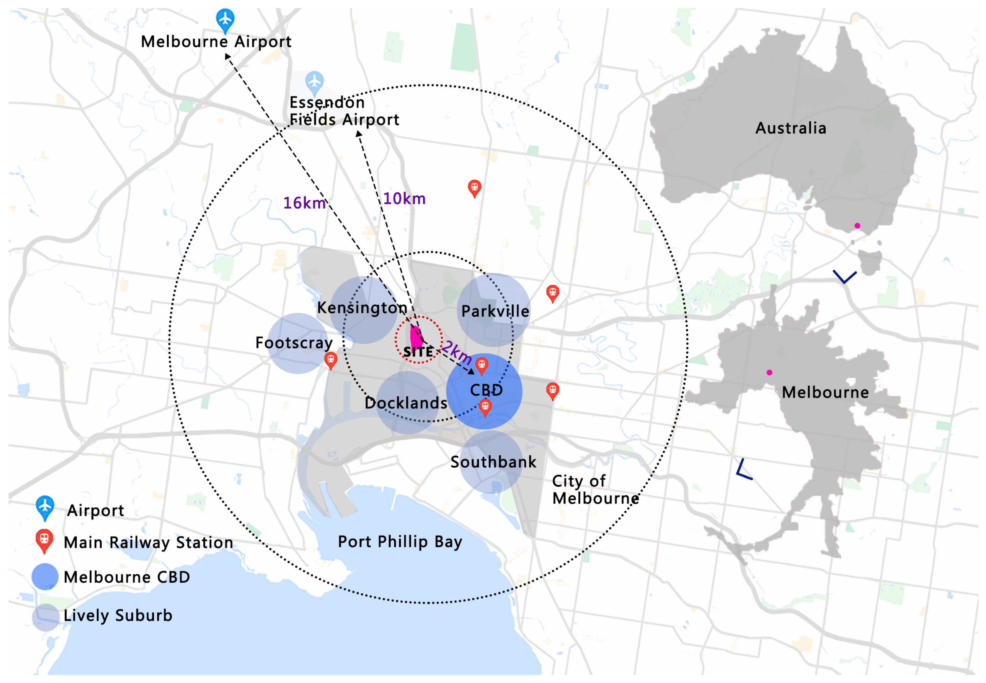
2.1. Study Area
2.2. Method
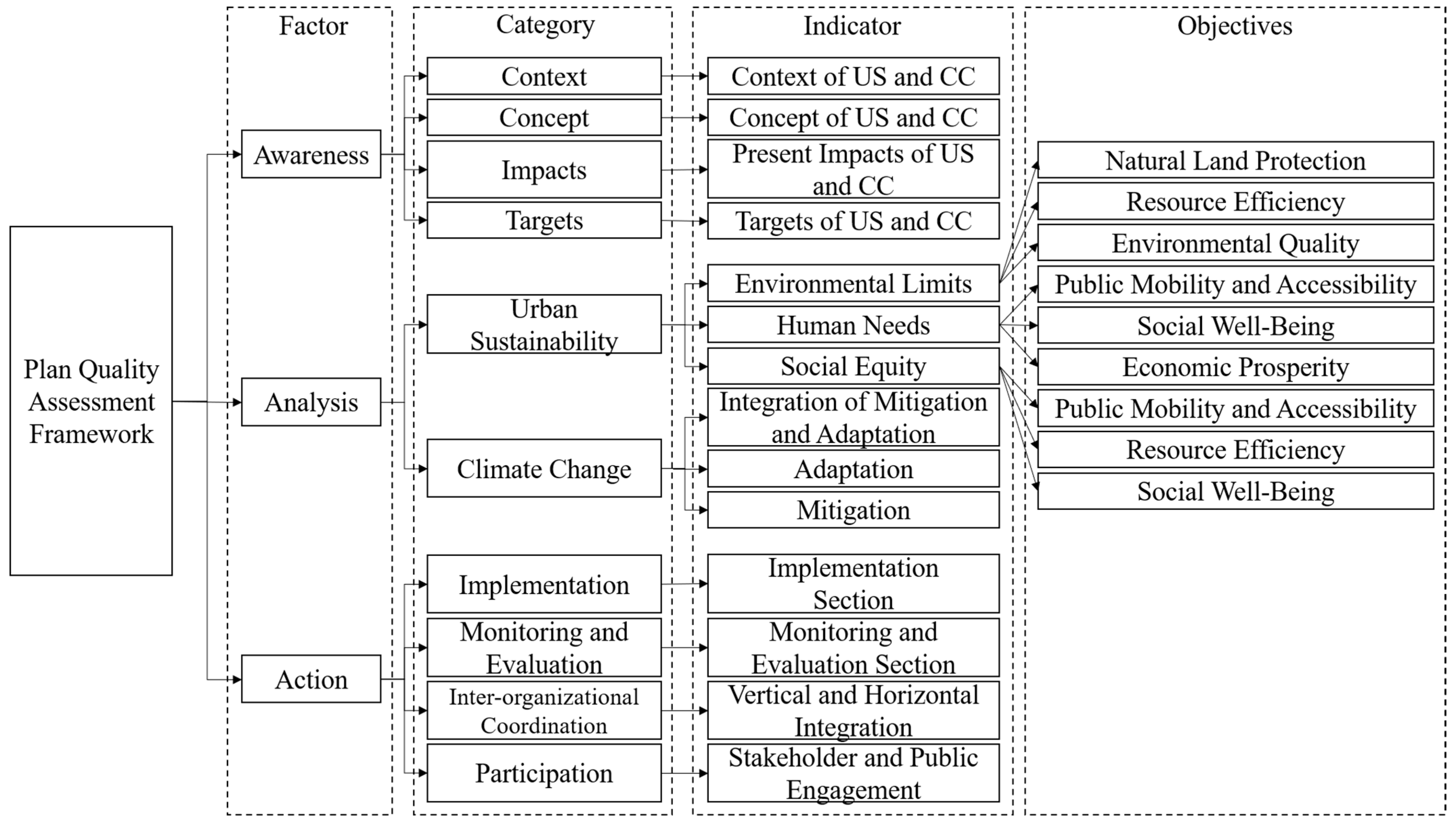
2.2.1. Assessment Framework
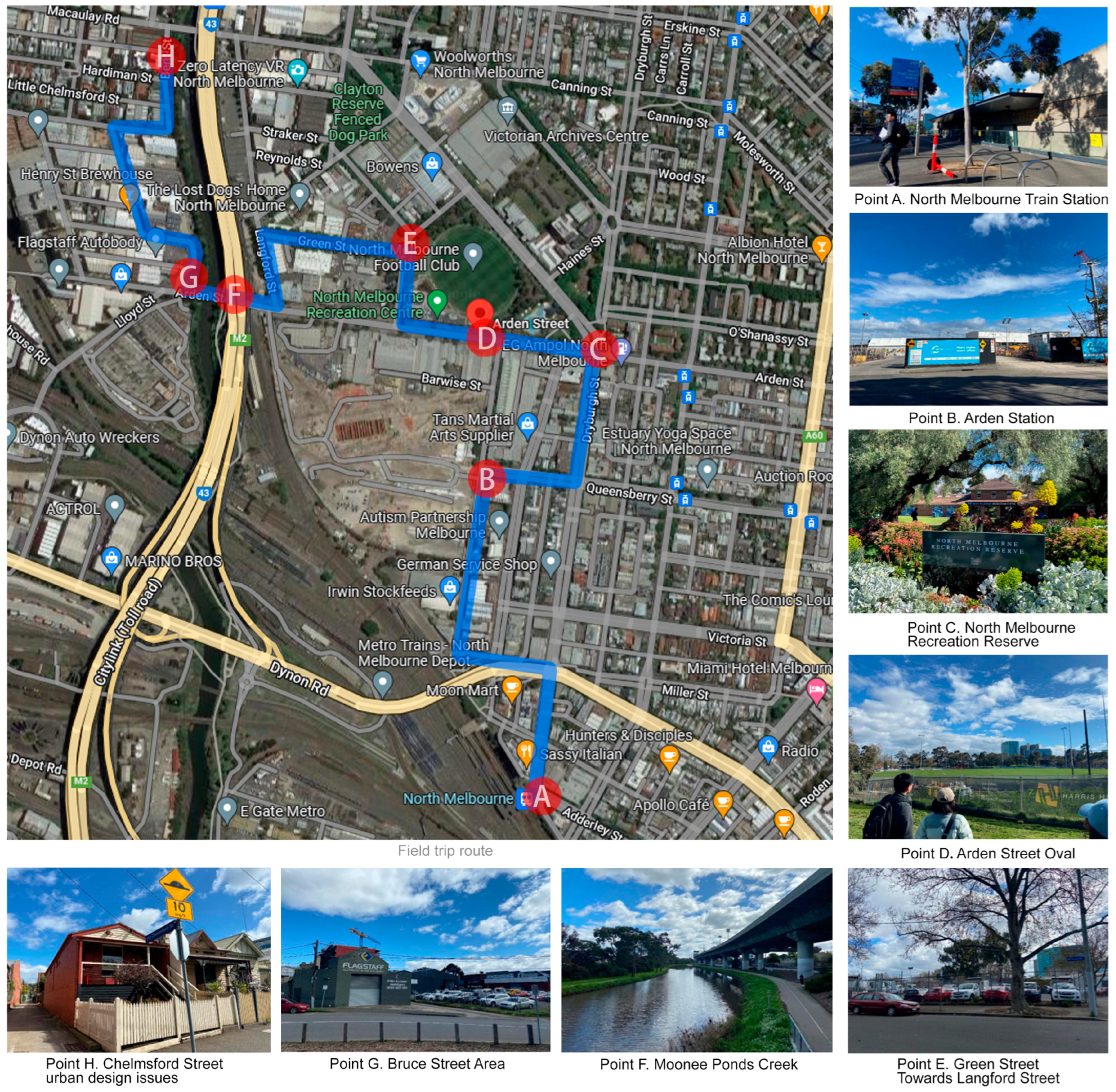
2.2.2. Fieldwork and Scoring Protocol
3. Results
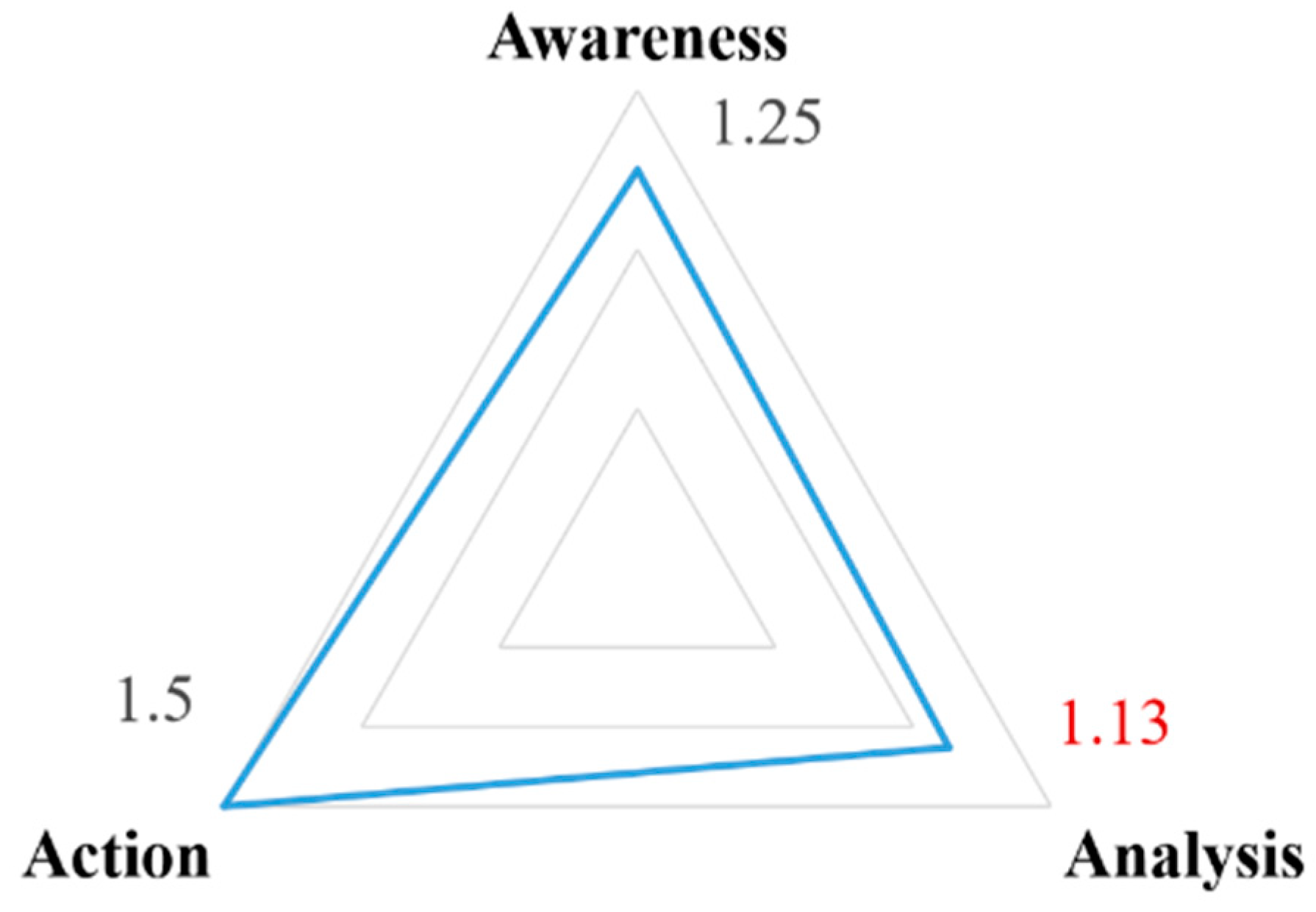
3.1. Overview
3.2. Quality of Awareness
3.3. Quality of Analysis
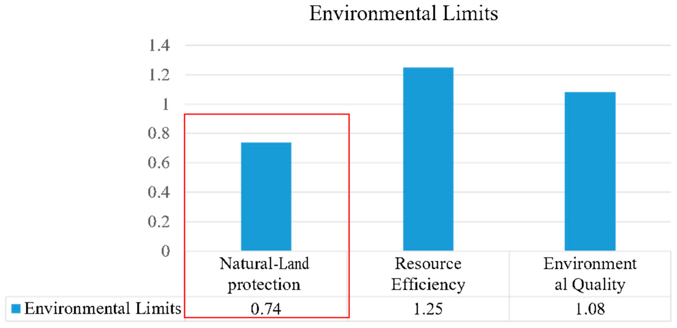
3.3.1. Urban Sustainability
- (1)
- Environmental Limits
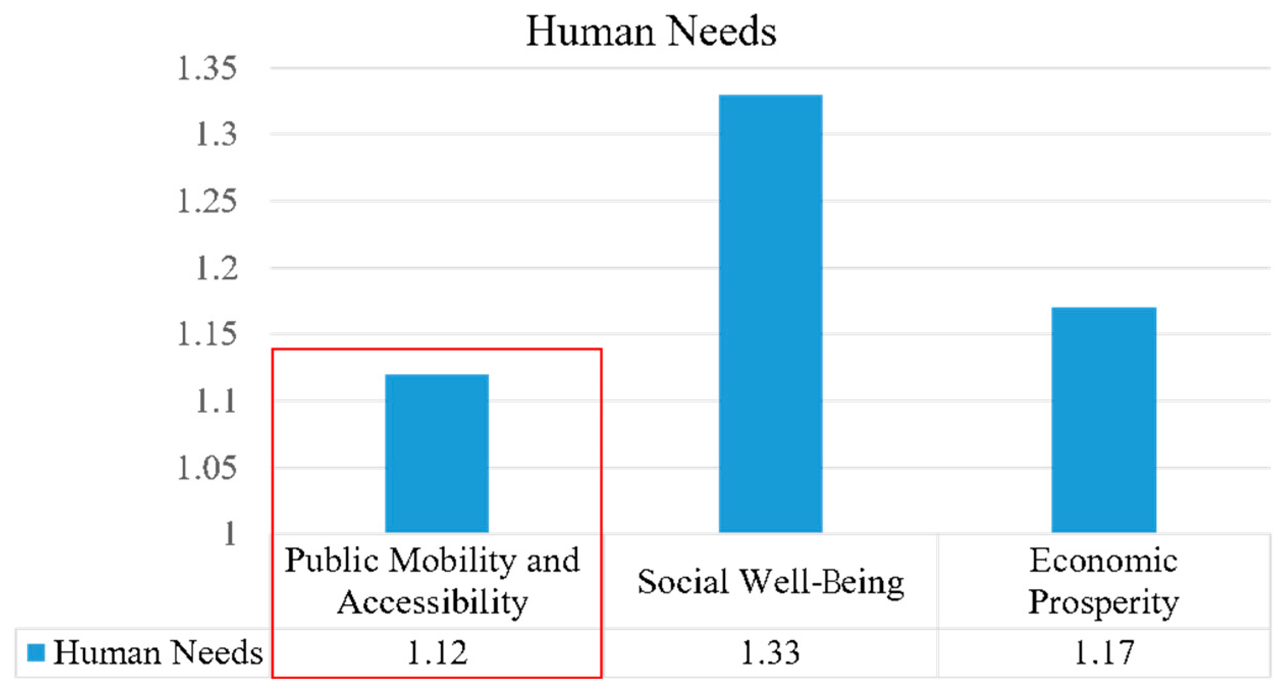
- (2)
- Human Needs
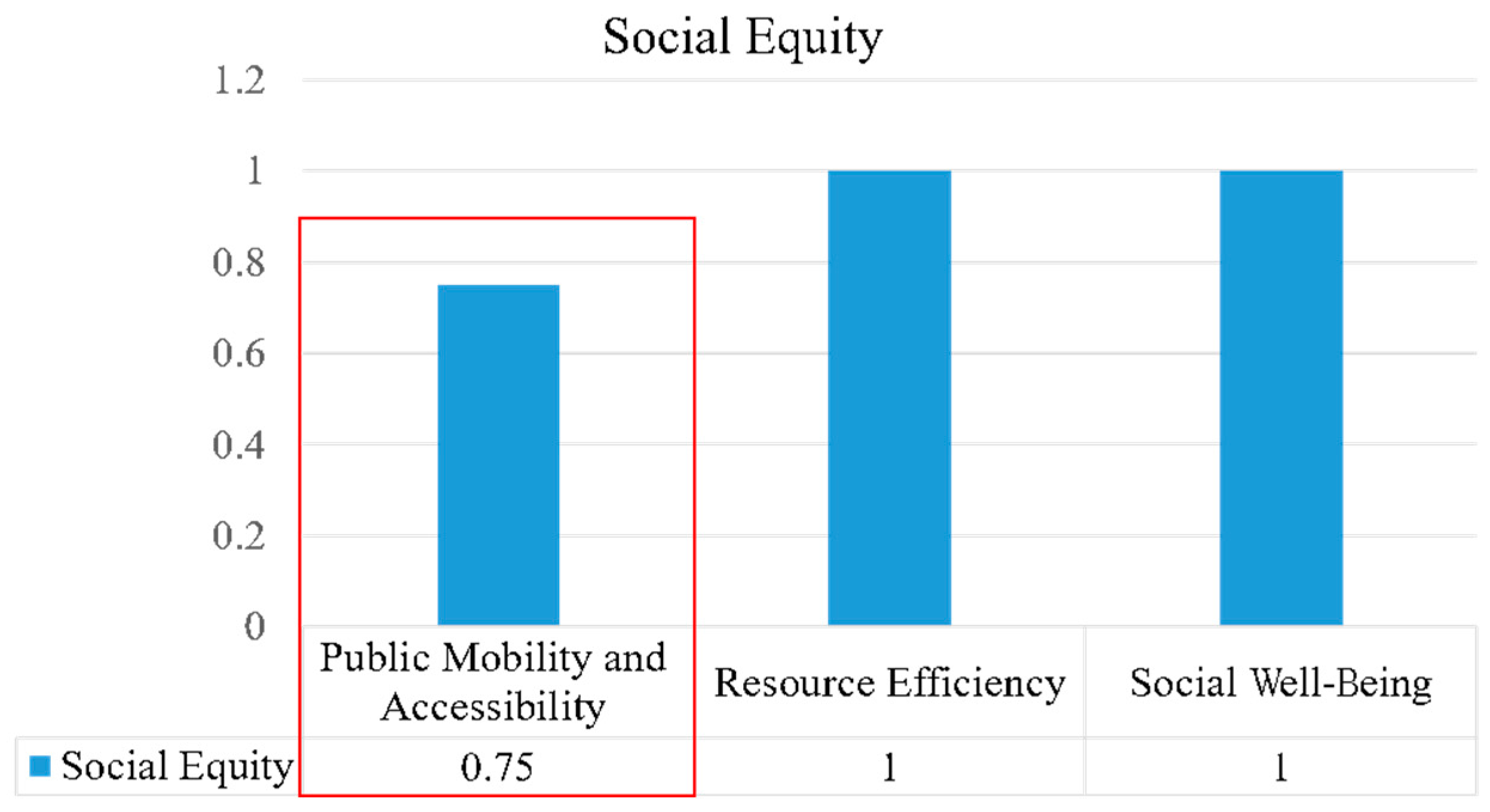
- (3)
- Social Equity
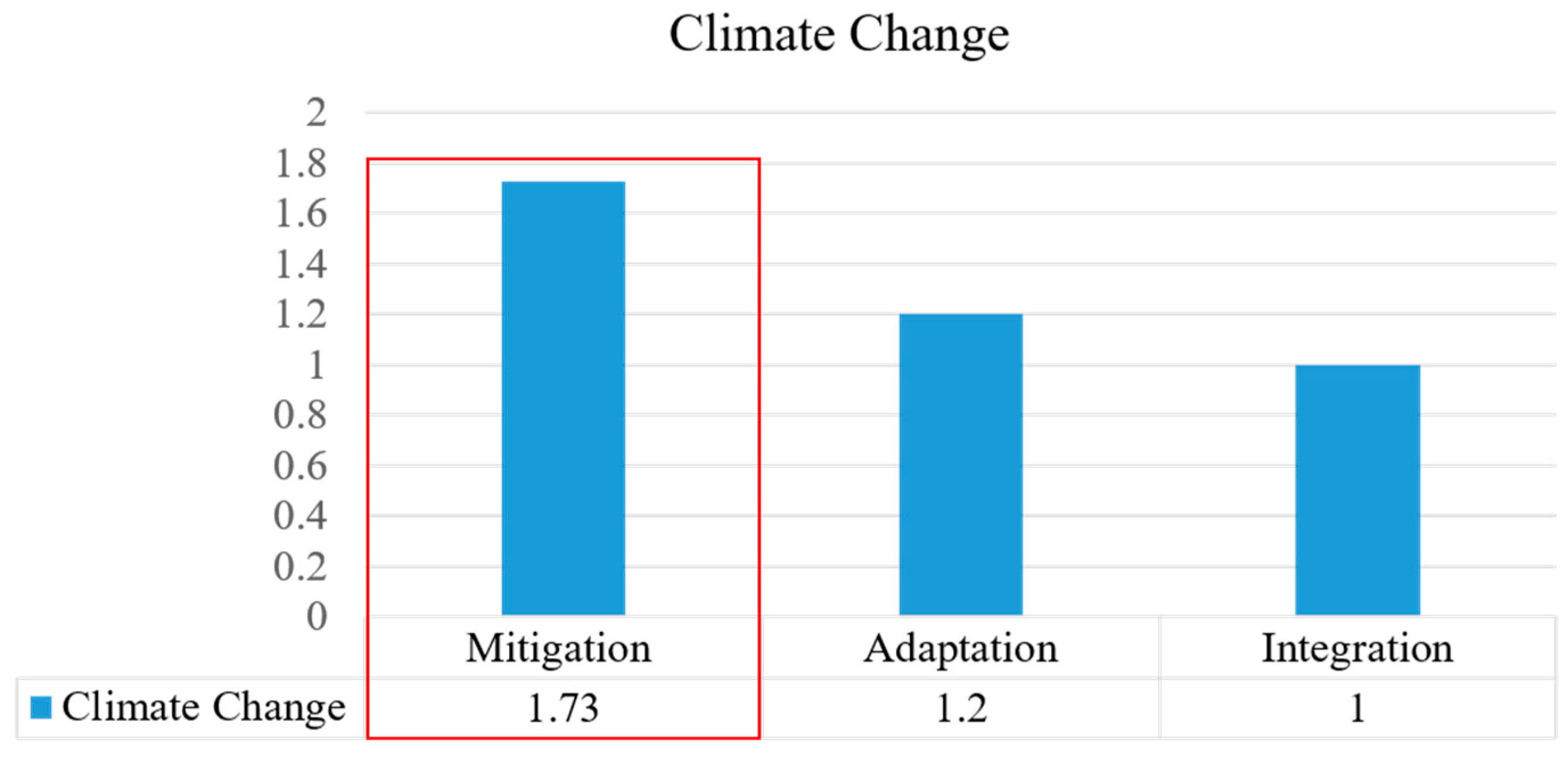
3.3.2. Climate Change
- (1)
- Mitigation
- (2)
- Adaptation
- (3)
- Integration of Adaptation and Mitigation
3.4. Quality of Action
4. Discussion
5. Conclusions
Author Contributions
Funding
Institutional Review Board Statement
Informed Consent Statement
Data Availability Statement
Acknowledgments
Conflicts of Interest
Appendix A

| Plan Quality Assessment Framework | ||||||
|---|---|---|---|---|---|---|
| Factors | Category | Indicator | Objectives | Description/Criteria | Score | Comments |
| Awareness | Context | Context of Urban Sustainability and Climate Change | —— | Does the plan include urban sustainability and climate change issues in the context of the site? | 1 | The plan mentions the history, current development, and shortcomings of Arden in a context partly in relation to urban sustainability but is vague. |
| Concept | Concept of Urban Sustainability and Climate Change | —— | Does the plan include a description of the causes of climate change and the knowledge of urban sustainability? | 1 | This plan does not specifically describe sustainability and climate change, but the strategy covers both perspectives. | |
| Impacts | Present Impacts of Urban Sustainability and Climate Change | —— | Does the plan include a discussion of the general impacts of climate change and urban sustainability? | 1 | The plan mentions relevant content but lacks systematic descriptions. | |
| Targets | Targets of Urban Sustainability and Climate Change | —— | Does the plan include at least one goal related to climate change and urban sustainability? | 2 | The plan proposes to embed sustainable change and some strategies related to climate change. | |
| Analysis | Urban Sustainability | Environmental Limits | Natural-Land Protection | Nearby drinking water supply or source | 0 | Arden is considering an alternative water supply for indoor and outdoor non-potable uses in Arden. Alternative water sources under investigation include local storm water harvesting and sewer mining. |
| Nearby wastewater system | 0 | The plan only mentions natural water management. | ||||
| Nearby transportation infrastructure | 2 | The plan proposes high-capacity-capable public transport options and transport links. | ||||
| Brownfield area | 1 | The plan mentions the management of land contamination | ||||
| Existence of imperilled species | 0 | This criterion is not mentioned but should be considered. | ||||
| Distance from wetlands (ft.) | 1 | The plan describes that Arden was formerly a low-lying wetland. | ||||
| Distance from water bodies (ft.) | 1 | Shown in vision plan. | ||||
| % of area (more than 15% slope) protected | 0 | This criterion is not mentioned but should be considered. | ||||
| Residential dwelling units per acre of buildable land | 0 | This criterion is not mentioned but should be considered. | ||||
| Use of corridors, etc., to form networks with the surroundings (continuity of green space through rows of trees, shrubbery, etc.) | 1 | The plan proposes that green links and green streets will continue to be transformed through extensive tree planting. | ||||
| Environment building, considering natural flora in the surroundings | 0 | This criterion is not mentioned but should be considered. | ||||
| % of urban area protected as agricultural area for fresh food | 0 | This criterion is not mentioned but should be considered. | ||||
| Groundwater pumping | 2 | Arden currently has five existing pumps and the Arden Flood Management Strategy proposes to upgrade the pumping stations and pipelines. The URCRS will also collect funds from developers to build pump stations. | ||||
| % of 1-year, 24-h storm runoff volume across the community | 0 | No information in the plan, only a maximum storage capacity of 40 ML is mentioned. | ||||
| % of paved area in the designated area | 1 | Objective 17 mentions that pedestrian-priority areas will be enhanced by textured pavement changes, but there is no specific percentage. | ||||
| Reuse of construction site soil | 2 | Objectives 3 and 6 refer to the adaptive reuse of built heritage sites to adapt to changing community needs. | ||||
| Combination of utility lines to minimise land disturbance | 1 | The plan proposes combining residential development with commercial, which means that some routes will be combined, but this is not explicitly stated. Objective 4 proposes combining some blocks according to use needs, but still ensuring a connected, safe road network for smaller streets and driveways. | ||||
| Consideration of scenic appearance | 2 | Arden will be shaped by typical architectural forms. The architectural form of Laurens Streets complements and builds on the character of North Melbourne and will create a visual transition. | ||||
| % of buildable land protected as greenspace | 0 | This criterion is not mentioned but should be considered. | ||||
| Resource Efficiency | % of boundary connected or adjacent to developed urban area | 1 | The plan mentions the connection of the boundary road with other North Melbourne areas. | |||
| % of single-family dwellings | 0 | This criterion is not mentioned but should be considered. | ||||
| % of building sq. footage for which superstructure construction is employing BMPs for durability and moisture management | 0 | This criterion is not mentioned but should be considered. | ||||
| % of building sq. footage for which substructure is employing BMPs for durability and moisture control | 0 | This criterion is not mentioned but should be considered. | ||||
| % of building water use reduction below baseline buildings through the use of water-efficient fixtures | 1 | In the plan, water reuse and efficient energy consumption are embedded in building designs, but no specific data is provided. | ||||
| Mutual use of centralised rainwater storage tanks | 2 | Objective 20 mentions that new development can manage stormwater runoff from centralised wetlands through the provision of rainwater tanks. | ||||
| % of landscape area fulfilling the criteria for efficient irrigation systems | 2 | Objective 14 proposes a minimum tree canopy cover of 40% by 2040 under Melbourne’s Urban Forest Strategy. | ||||
| % of wastewater re-used | 1 | Arden Vision 2018 only mentions the reuse of greywater and stormwater, but percentage data is missing. | ||||
| % capacity of alternative treatment systems beyond the initial design | 1 | Objective 10 refers to the early provision of alternative waste infrastructure on a regional scale to achieve sustainable development, but no specific percentage figures are available. | ||||
| Considerations to minimise water leakage in water supply systems | 0 | Information is lacking in the plan, but this is an important element to be considered. | ||||
| % of building sq. footage employing the use of energy-efficient fixtures and technologies | 1 | Objective 12 refers to ensuring that new technologies are introduced into buildings, such as energy trading technology and electrification of homes, but there is no data on percentages. | ||||
| % of energy from fossil fuels (natural gas, gasoline etc.)/hydro or other water-intensive energy sources | 1 | Strategy 10.4 refers to the provision of fossil-fuel-free infrastructure for most areas, supporting net-zero carbon emission ambitions, but lacks basic data on the high energy consumption still in use. | ||||
| % of energy from renewable sources | 2 | Strategy 10.1 sets out the ambition for the region to have access to 100% renewable energy and to explore procurement opportunities to address the energy needs of the surrounding communities. | ||||
| Centralised storage facilities for waste collection and facilities to reduce volume and employ composting | 2 | Strategy 10.2 refers to promoting and encouraging the centralisation and sharing of waste management sites in order to reduce freight and waste vehicle emissions. | ||||
| Use of locally produced materials for building cladding, paving and other materials. | 2 | Strategy 13.3 proposes to encourage the use of locally sourced building materials. | ||||
| Reduction of the generation of construction by-products | 2 | Strategy 13.3 proposes to encourage the use of low-carbon-content feedstocks or production, where possible. | ||||
| Sorting and recycling of construction by-products | 2 | Strategy 13.3 proposes to encourage the composting, recycling, and reuse of construction materials. | ||||
| Use of recycled products (recycled aggregate, blast furnace cement, electric furnace steel, etc.) | 2 | Strategy 13.3 proposes to encourage the use of renewable raw materials. | ||||
| Use of materials with low climate change impact (blended cement, etc.) | 2 | Strategy 13.3 proposes to encourage the use of non-hazardous building materials. | ||||
| Use of timber from sustainable forestry | 1 | Strategy 13.3 indirectly expresses the use of sustainable materials but does not mention sustainable forestry. | ||||
| Environmental Quality | Urban form that secures continuity of airflow within open spaces | 2 | The plan mentions designing to ameliorate the effects of unsafe wind conditions and deliver comfortable wind conditions in the public realm for walking, sitting, or standing. | |||
| Counter measures against strong winds for regional characteristics | 0 | The plan mentions wind control but no measures, and the mention seems unrelated to strong winds. | ||||
| % of hardscape with a surface reflectance index (SRI) >30 | 1 | The plan requires all new buildings to use materials that minimise the urban heat island effect with a standard that at least 75 percent of total project site areas should comprise building or landscaping elements that increase the solar reflectance of the site. | ||||
| % of building sq. footage for which BMPs are followed to ensure better indoor environmental quality | 0 | This criterion is not mentioned but should be considered. | ||||
| Horizontal shaded area ratio from medium and tall trees, e.g., pilotis, eaves, pergolas, etc. | 2 | The plan proposes that a target of 40 per cent canopy coverage should be achieved in the public realm over time. | ||||
| % of residential area within a 300 m walk from green space (≥2 hectares in size) | 1 | The service distance of public space is considered in the plan, but there is no specific data about residential areas. | ||||
| % of building sq. footage designed for high-performance building development | 2 | Strategy 14.2 requires that new buildings reduce materials that lead to the urban heat island effect and that at least 75% of the buildings or landscape elements on the site should have increased solar reflectance. | ||||
| Reduction of waste heat | 2 | Objective 14 proposes that Melbourne is actively tackling this issue by ‘greening’ the public realm, cooling the environment by providing shade, and transferring heat in the landscape. | ||||
| % of decrease in impervious area | 1 | The urban water cycle and integrated water management mentions that in Arden, impervious surfaces have significantly altered local water systems and reduced evaporation, which Melbourne will mitigate through the greening of public areas, but no specific data is available. | ||||
| % of project pavements built with a minimum albedo of 0.3 or permeable pavements/pavers | 0 | This criterion is not mentioned but should be considered. | ||||
| % of streets with trees on both sides with an avg. of 40 ft. spacing | 1 | Strategy 22.3 proposes a tree cover of 40% but does not address average spacing. | ||||
| Distance from critical flood plain (100–1000 years) | 0 | This criterion is not mentioned but should be considered. | ||||
| % of green space area to reduce heat island effect | 2 | The plan requires all new buildings to meet a standard of 40 per cent total surface area as green cover; this achieves a minimum canopy cover of 40 per cent by 2040. | ||||
| Human Needs | Public Mobility and Accessibility | % of residential area within 600 m of stores, banks, and administrative buildings | 1 | There is a land function zoning map in the plan, but no specific data. | ||
| % of residential area within 600 m of medical and welfare facilities | 1 | There is a land function zoning map in the plan, but no specific data. | ||||
| % of residential area within 600 m of educational and cultural facilities | 1 | There is a land function zoning map in the plan, but no specific data. | ||||
| % of building frontages with 25 ft. or less of setback | 1 | Strategy 5.1 proposes controls for setbacks, but no specific data are available. | ||||
| Measures taken to manage the traffic demand | 2 | The plan proposes that Arden will prioritise people walking, cycling, and using public transport to meet their daily needs. A network of walkable streets and protected cycle paths is planned. | ||||
| Measures taken to calm traffic in urban centres | 2 | The plan states that Arden-Central Innovation will be activated by a new metro station. | ||||
| % of parking space reduction below the local minimum or ECC criteria | 1 | Objective 18 refers to controlling the number of parking spaces and encouraging public transport through parking overlays and other planning controls. However, specific data are missing. | ||||
| Provision of adequate bike lanes for roads with speed limits of 35 mph or over | 1 | Objective 16 refers to the provision of safe, direct, and connected protected cycle paths. | ||||
| Accommodation of bicycles near all primary building entrances | 0 | Objective 17 proposes that the streets of the new station in Arden will be accessible to slow-moving cyclists, but does not specifically mention the entrances and exits of all major buildings. | ||||
| % of roads (speed limit >30 mph) with a footpath width of more than or equal to 900 mm on both sides | 0 | This criterion is not mentioned but should be considered. | ||||
| % of bus-stop shelters with all-weather protection (rain, wind, and snow) and renewable lighting/heating | 0 | This criterion is not mentioned but should be considered. | ||||
| Visibility from the surroundings | 2 | Objective 18 proposes that new and existing streets will be pedestrian friendly and provide comfortable, green links between open spaces and public transport routes and enhance the quality of the public realm, so the urban spaces are visible and accessible. | ||||
| Ease of approach by people with criminal intent | 0 | There is no description in the plan about criminal intent. | ||||
| Provision of street furniture, signs, etc. | 1 | The plan provides a complete list of infrastructure items, but it does not mention street facilities in detail. | ||||
| Other considerations (lighting, sound, etc.) | 2 | Objective 28 proposes to ensure that the urban environment is not unduly impacted by noise, vibration, or electromagnetic interference from the adjacent railway corridor, elevated roadway, or Metro Tunnel. | ||||
| Provision of road width (at least 8 m) and formation of a network of evacuation routes in 2 directions | 2 | Objective 4 proposes to create a new urban structure for Arden that incorporates a high-quality network of connected streets, which has minimum of 8 m wide lanes. | ||||
| Continuation of the pre-existing community | 2 | The plan is about urban regeneration, so it is an optimisation of the pre-existing community. | ||||
| Social Well-Being | % of project pavements that reduce tire–pavement noise levels below certain limits | 0 | This criterion is not mentioned but should be considered. | |||
| Noise and vibration counter measures | 2 | Objective 28 refers to the state government’s efforts to relocate industrial businesses out of the district to ensure that noise disturbance from industrial sites is eliminated. The tunnel design of the metro also includes measures to mitigate vibration and noise disturbance. | ||||
| Provision of crime prevention facilities, such as surveillance cameras and guards (surveillance of blind spots) | 2 | Strategy 17.5 proposes, through the use of Crime Prevention Through Environment Design principles, to promote the use of open space and the ground floor around major pedestrian routes to maximise personal safety. | ||||
| Economic Prosperity | % of regularly trafficked lanes designed for long lives (≥40 years) | 0 | No information is mentioned in the plan. | |||
| Efforts to track pavement performance through testing and condition-assessment procedures | 1 | Strategy 17.7 proposes to review and update road speed limits in accordance with Arden’s principles for movement, but there are no specific procedures or measures. | ||||
| Development of facilities related to local industries and cultures | 2 | Objective 1 proposes to celebrate, protect, and interpret Aboriginal cultural values and heritage in the planning, design, and curation of Arden. | ||||
| % of labour from local area | 2 | Strategy 3.1 proposes to facilitate the use and development of land in Arden to deliver on the aspiration of approximately 34,000 jobs and around 15,000 residents in the precinct. | ||||
| Proportion of total house and land packages delivered to the market at an affordable purchase price (less than 270,000$—2008 figure—Australia) for moderate-income households | 2 | Objective 23 proposes that at least 6% of all new housing in Arden will be affordable for very low- to moderate-income households and delivered as social and affordable housing or shared equity. | ||||
| % of land costs at the lowest quartile of the local market | 0 | There is nothing in the plan about land costs. | ||||
| Social Equity | Public Mobility and Accessibility | Realisation of barrier-free outside spaces for the infirm or handicapped | 1 | Strategy 18.2 plans to provide disabled parking. Strategy 25.5 proposes to provide diverse and adaptable community facilities to become beneficial to people with disabilities, but the measures are quite general. | ||
| Participation of residents of the designated area in planning processes | 0 | There is nothing in the plan about the participation of residents. | ||||
| Consideration of encounter | 2 | Objective 21 proposes to provide generous, well-designed, and accessible open spaces that are diverse and flexible to meet the needs of Arden’s evolving community and visitors of the precinct. | ||||
| % of primary entryways facing public spaces | 0 | This criterion is not mentioned but should be considered. | ||||
| Resource Efficiency | Reasonable redistribution of resources for vulnerable groups | 1 | Objective 5 proposes to make Arden become a world-leading urban renewal and innovation precinct. Urban renewal is one way for the redistribution of resources. | |||
| Social Well-Being | Embracing and recognising differences | 0 | The plan does not mention the recognition and inclusion of social differences. | |||
| Overcoming gentrification and residential segregation | 2 | Objective 23 proposes to facilitate inclusive, well-designed, sustainable, and accessible housing, with affordable housing for very low- to moderate-income households delivered as social and affordable housing or shared equity. | ||||
| Climate Change | Mitigation | —— | Does the plan address climate change mitigation? | 2 | The plan promotes climate change mitigation, such as minimising waste production and mitigating the urban heat island effect. | |
| Is a mitigation aim specified (e.g., a specific level of warming limit or goals for GHG-emission reduction)? If yes, what level? | 2 | Objective 9 proposes to establish strong environmental governance in Arden to achieve the precinct’s net-zero carbon emissions target by 2040, which is adequate to achieve the standard of the Paris Agreement. | ||||
| Affordable housing mandates | 2 | Objective 23 proposes that at least 6% of all new housing in Arden will be affordable for very low- to moderate-income households and delivered as social and affordable housing or shared equity. | ||||
| Mixed-use zoning to support self-contained communities | 2 | Objective 25 proposes to ensure the timely delivery of high-quality, accessible, and integrated community infrastructure to meet the needs of existing and future residents, workers, and visitors. | ||||
| Transfer of development rights to support transit-oriented corridors | 1 | Objective 15 proposes to provide space for high-capacity-capable public transport options and to improve transport links connecting Arden to the expanding central city, but it does not mention the development rights. | ||||
| Mixed-use zoning to encourage urban regeneration and infill | 2 | The plan focuses on the urban renewal of Arden and encourages the efficient and diverse use of land. | ||||
| Zoning overlays and form-based codes to achieve desired outcomes, such as new urbanism | 2 | Strategy 5.1 implements built-form controls in the planning scheme that respond to key design recommendations. | ||||
| Design codes and flexible parking to achieve transit-oriented development | 2 | Strategy 18.1 proposes to prepare planning controls that direct the ongoing supply and location of car parking to achieve the 10% mode-share target for private vehicles and car parking principles, and then minimise the impact of car parking and associated vehicular movements through Arden. | ||||
| Mixed-use zoning to support eco-communities | 1 | The plan concentrates on sustainable change in the community, including some measures of eco-communities, but it does not have a systematic description. | ||||
| Code revisions/design guidelines for pedestrian zones | 2 | Strategy 17.1 proposes to facilitate a network of permeable streets and pedestrian links through the precinct for walking and cycling that are considerate of safety and convenience and provide direct access to and from key destinations. | ||||
| Code revisions/design guidelines to achieve car-free districts and/or traffic calming | 1 | Strategy 17.1 encourages the consolidation of servicing facilities and alternative freight-delivery models within the precinct to reduce the number of vehicles entering and circulating, but there is no description of a car-free district. | ||||
| Adaptation | —— | Does the plan address climate change adaptation? | 2 | Objective 12 proposes to measure the performance of the precinct, its buildings, and its occupants to be able to adapt to changes in climate, lifestyle, and technology in the future. | ||
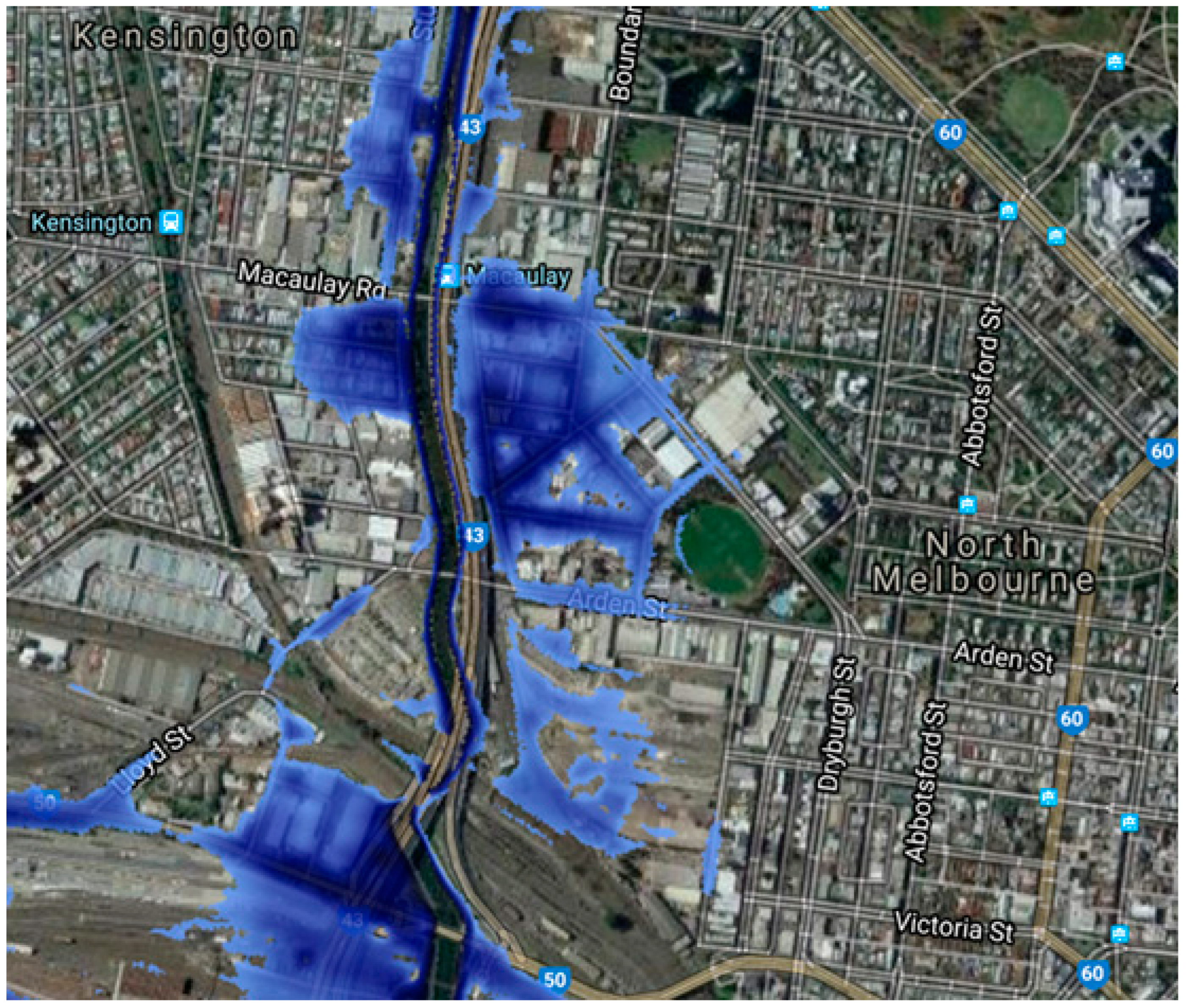
| What level of flood risk is planned for, and across what time frame? | 0 | The plan mentions flood management, but there is no clear planning, level, or timing. | ||||
| Does the approach to flooding consider retreat? | 0 | The plan does not consider retreat for flooding. | ||||
| Does the approach to flooding consider accommodation? | 2 | Strategy 19.4 positively responds to any necessary level changes that are required for drainage purposes between development and the public realm, to accommodate flooding problems. | ||||
| Does the approach to flooding consider protection? | 2 | There is a precinct-wide flood management strategy for Arden to provide guidance on how development can achieve flood-responsive design and good urban design outcomes that facilitate safety, equitable access, and universal design. | ||||
| Integration of Mitigation and Adaptation | —— | Is the integration of adaptation and mitigation acknowledged? | 1 | The plan mentions both adaptation and mitigation, but neither is called one-sided or described systematically. | ||
| Action | Implementation | Implementation Section | —— | Does the plan include a separate section that addresses what needs to be done to implement the plan? | 2 | Section 10 in the plan, called Delivery Arden, mention the development staging of Arden. |
| Monitoring and Evaluation | Monitoring and Evaluation Section | —— | Does the plan include a separate section that addresses what needs to be done to monitor and evaluate the plan? | 1 | The plan only mentions the lead agency. | |
| Inter-organisational Coordination | Vertical and Horizontal Integration | —— | Does the plan include at least one vertical connection to federal, provincial, or regional plans or at least one horizontal connection with other local plans/programs? | 2 | The plan has connections with other plans such as the Moonee Ponds Creek Strategic Opportunities Plan. | |
| Participation | Stakeholder and Public Engagement | —— | Does the plan identify the organisations and stakeholders involved in the plan-making process and identify the public as part of the plan making process? | 1 | The plan only mentions the lead agency and lacks public participation. | |
References
- Wikipedia. 2022. Available online: https://en.wikipedia.org/wiki/Structure_plan (accessed on 21 October 2022).
- Chen, Y. 408 Research Group|Structural Planning in Melbourne. 2019. Available online: http://www.360doc.com/content/19/1010/06/32324834_865850902.shtml (accessed on 21 October 2022).
- Victoria State Government. 2022. Available online: https://www.planning.vic.gov.au/policy-and-strategy/activity-centres/structure-planning (accessed on 22 October 2022).
- Qin, D.H. Climate change sciences into the 21st century: Facts, impact and strategies addressing climate change. Sci. Technol. Rev. 2004, 7, 4–7. [Google Scholar]
- Baettig, M.B.; Wild, M.; Imboden, D.M. A climate change index: Where climate change may be most prominent in the 21st century. Geophys. Res. Lett. 2007, 34, L01705. [Google Scholar] [CrossRef]
- Hansen, J.; Sato, M.; Hearty, P.; Ruedy, R.; Kelley, M.; Delmotte, V.M.; Russell, G.; Tselioudis, G.; Cao, J.J.; Rignot, E.; et al. Ice melt, sea level rise and superstorms: Evidence from paleoclimate data, climate modeling, and modern observations that 2 °C global warming could be dangerous. Atmos. Chem. Phys. 2016, 16, 3761–3812. [Google Scholar] [CrossRef]
- Hamilton, C. Requiem for a Species: Why We Resist the Truth About Climate Change; Allen & Unwin: Sydney, NSW, Australia, 2010. [Google Scholar]
- McManus, P. Sustainability, Planning and Urban Form. Aust. Plan. 2012, 49, 293–302. [Google Scholar] [CrossRef]
- United Nations Environment Programme. Emissions Gap Report 2021: The Heat Is On—A World of Climate Promises Not Yet Delivered: Executive Summary. 2021. Available online: https://wedocs.unep.org/xmlui/handle/20.500.11822/36991 (accessed on 18 October 2022).
- ABS. Melbourne Population 2022 (Demographics, Maps, Graphs). 2022. Available online: https://worldpopulationreview.com/world-cities/melbourne-population (accessed on 21 October 2022).
- Department of Planning and Community Development, Victoria State Government. Activity Centres Toolkit: Making It Happen. 2010. Available online: https://www.planning.vic.gov.au/__data/assets/pdf_file/0032/97079/190_Activity_Centres_Toolkit_web.pdf (accessed on 3 September 2022).
- Shahab, S.; Clinch, J.P.; O’Neill, E. Impact-based planning evaluation: Advancing normative criteria for policy analysis. Environ. Plan. B Urban Anal. City Sci. 2017, 46, 534–550. [Google Scholar] [CrossRef]
- Norton, R.K. Using content analysis to evaluate local master plans and zoning codes. Land Use Policy 2008, 25, 432–454. [Google Scholar] [CrossRef]
- Lyles, W.; Stevens, M. Plan quality evaluation 1994–2012: Growth and contributions, limitations, and new directions. J. Plan. Educ. Res. 2014, 34, 433–450. [Google Scholar] [CrossRef]
- Sanderson, I. Evaluation, policy learning and evidence-based policy making. Public Adm. 2002, 80, 1–22. [Google Scholar] [CrossRef]
- Tang, K. Carry out planning evaluation to promote planning reform. City Plan. Rev. 2011, 35, 9–10. [Google Scholar]
- Guyadeen, D.; Seasons, M. Evaluation Theory and Practice: Comparing Program Evaluation and Evaluation in Planning. J. Plan. Educ. Res. 2016, 38, 98–110. [Google Scholar] [CrossRef]
- Rudolf, S.C.; Grădinaru, S.R. The quality and implementation of local plans: An integrated evaluation. Environ. Plan. B Urban Anal. City Sci. 2019, 46, 880–896. [Google Scholar] [CrossRef]
- Stevens, M.R. Evaluating the quality of official community plans in Southern British Columbia. J. Plan. Educ. Res. 2013, 33, 471–490. [Google Scholar] [CrossRef]
- Lyles, W.; Berke, P.; Smith, G. Local plan implementation: Assessing conformance and influence of local plans in the United States. Environ. Plan. B Plan. Des. 2016, 43, 381–400. [Google Scholar] [CrossRef]
- Talen, E. After the plans: Methods to evaluate the implementation success of plans. J. Plan. Educ. Res. 1996, 2, 79–97. [Google Scholar] [CrossRef]
- Alexander, E.R.; Faludi, A. Planning and plan implementation: Notes on evaluation criteria. Environ. Plan. B Plan. Des. 1989, 2, 127–140. [Google Scholar] [CrossRef]
- Faludi, A. A decision-centred view of environmental planning. Landsc. Plan. 1985, 3, 239–256. [Google Scholar] [CrossRef]
- Berke, P.R.; Godschalk, D.R.; Kaiser, E.J.; Rodriguez, D.A. Urban Land Use Planning; University of Illinois Press: Chicago, IL, USA, 2006. [Google Scholar]
- Chadwick, G. A System View of Planning; Pergamon Press Ltd.: Oxford, UK, 1978. [Google Scholar]
- Foley, P.; Hutchinson, J.; Fordham, G. Managing the Challenge: Winning and Implementing the Single Regeneration Budget Fund. Plan. Pract. Res. 1998, 13, 63–80. [Google Scholar] [CrossRef]
- Leung, H.L. Towards a Subjective Approach to Policy Planning & Evaluation: Common-Sense Structured; Ding, J.F., Translator; China Renmin University Press: Beijing, China, 2009. [Google Scholar]
- Leung, H.L. S-CAD Public Policy Evaluation Act Operations Manual; Institute of Policy Effects, Central University of Finance and Economics & Queen’s University: Beijing, China, 2015. [Google Scholar]
- Li, D.X.; Wang, X.P.; Bai, L.L.; Liu, S.F. Application of S-CAD Approach in Urban-Rural Planning Evaluation. Urban Plan. Int. 2020, 35, 114–123. [Google Scholar]
- Wang, J.; Chen, X. Research on British Planning Evaluation System and Its Reference to China. Urban Plan. Int. 2019, 34, 86–91. [Google Scholar] [CrossRef]
- Portland Bureau of Planning. Comprehensive Plan Assessment Portland Plan. Available online: https://www.portlandonline.com/portlandplan/index.cfm?a=191249&c=47107 (accessed on 8 January 2023).
- The Government of the Hong Kong Special Administrative Region (China). Territorial Development Strategy Review. 2007. Available online: https://www.epd.gov.hk/epd/english/environmentinhk/eia_planning/sea/territorial_dept.html (accessed on 8 January 2023).
- Zheng, D.G.; Yan, Y. Effectiveness and perceptiveness: Considerations on the assessment on city master planning. City Plan. Rev. 2013, 37, 37–42. [Google Scholar]
- Holden, E.; Linnerud, K.; Banister, D.; Schwanitz, V.J.; Wierling, A. The Imperatives of Sustainable Development: Needs, Justice, Limits; Routledge: London, UK, 2017. [Google Scholar]
- Sala Benites, H.; Osmond, P.; Rossi, A.M.G. Developing low-carbon communities with LEED-ND and climate tools and policies in São Paulo, Brazil. J. Urban Plan. Dev. 2020, 146, 04019025. [Google Scholar] [CrossRef]
- Feleki, E.; Vlachokostas, C.; Moussiopoulos, N. Characterisation of sustainability in urban areas: An analysis of assessment tools with emphasis on European cities. Sustain. Cities Soc. 2018, 43, 563–577. [Google Scholar] [CrossRef]
- Haider, H.; Hewage, K.; Umer, A.; Ruparathna, R.; Chhipi-Shrestha, G.; Culver, K.; Holland, M.; Kay, J.; Sadiq, R. Sustainability assessment framework for small-sized urban neighbourhoods: An application of fuzzy synthetic evaluation. Sustain. Cities Soc. 2018, 36, 21–32. [Google Scholar] [CrossRef]
- Komeily, A.; Srinivasan, R.S. A need for balanced approach to neighborhood sustainability assessments: A critical review and analysis. Sustain. Cities Soc. 2015, 18, 32–43. [Google Scholar] [CrossRef]
- Larsen, S.V.; Kørnøv, L. SEA of river basin management plans: Incorporating climate change. Impact Assess. Proj. Apprais. 2009, 27, 291–299. [Google Scholar] [CrossRef]
- Grafakos, S.; Pacteau, C.; Wilk, D.; Driscoll, P.A.; O’Donaghue, S.; Roberts, D.; Landauer, M. Integrating Mitigation and Adaption: Opportunities and Challenges. In Climate Change and Cities: Second Assessment Report of the Urban Climate Change Research Network; Cambridge University Press: Cambridge, UK, 2018; pp. 101–138. [Google Scholar]
- Hurlimann, A.; Moosavi, S.; Browne, G.R. Urban planning policy must do more to integrate climate change adaptation and mitigation actions. Land Use Policy 2021, 101, 105188. [Google Scholar] [CrossRef]
- Lukasiewicza, A.; Vellaa, K.; Mayerea, S.; Bakera, D. Declining trends in plan quality: A longitudinal evaluation of regional environmental plans in Queensland, Australia. Landsc. Urban Plan. 2020, 203, 103891. [Google Scholar] [CrossRef]
- Cidell, J. Cooperating on Urban Sustainability: A Social Network Analysis of Municipalities across Greater Melbourne. Urban Policy Res. 2020, 38, 150–172. [Google Scholar] [CrossRef]
- Victorian Planning Authority. Arden Structure Plan; Victorian Planning Authority: Melbourne, VIC, Australia, 2022; Volume 2022, p. 123. [Google Scholar]
- Brody, S.D. Are we learning to make better plans? A Longitudinal analysis of plan quality associated with natural hazards. J. Plan. Educ. Res. 2003, 23, 191–201. [Google Scholar] [CrossRef]
- Potts, R. The good, the bad, and the statutory: Are statutory or non-statutory natural resource management plans higher in quality? J. Environ. Policy Plan. 2017, 19, 668–681. [Google Scholar] [CrossRef]
- Baker, I.; Peterson, A.; Brown, G.; McAlpine, C. Local government response to the impacts of climate change: An evaluation of local climate adaptation plans. Landsc. Urban Plan. 2012, 107, 127–136. [Google Scholar] [CrossRef]
- Kim, H.W.; Li, M.-H. Managing stormwater for urban sustainability: An evaluation of local comprehensive plans in the Chesapeake Bay watershed region. J. Environ. Plan. Manag. 2017, 60, 1702–1725. [Google Scholar] [CrossRef]
- Elgendawy, A.; Davies, P.; Chang, H.C. Planning for cooler cities: A plan quality evaluation for Urban Heat Island consideration. J. Environ. Policy Plan. 2020, 22, 531–553. [Google Scholar] [CrossRef]
- Foreground. Reimagining Australia’s “Temperate Kakadu”. 25 January 2018. Available online: https://www.foreground.com.au/planning-policy/reimagining-australias-temperate-kakadu/ (accessed on 20 September 2022).
- Measham, T.G.; Preston, B.L.; Smith, T.F.; Brooke, C.; Gorddard, R.; Withycombe, G.; Morrison, C. Adapting to climate change through local municipal planning: Barriers and challenges. Mitig. Adapt. Strateg. Glob. Chang. 2011, 16, 889–909. [Google Scholar] [CrossRef]
- Tang, Z.; Brody, S.D.; Quinn, C.; Chang, L.; Wei, T. Moving from agenda to action: Evaluating local climate change action plans. J. Environ. Plan Manag. 2010, 53, 41–62. [Google Scholar] [CrossRef]
- Guyadeen, D.; Thistlethwaite, J.; Henstra, D. Evaluating the quality of municipal climate change plans in Canada. Clim. Chang. 2019, 152, 121–143. [Google Scholar] [CrossRef]
- Khakee, A. The Emerging Gap between Evaluation Research and Practice. Evaluation 2003, 9, 340–352. [Google Scholar] [CrossRef]
- Roberts, P. Evaluating Regional Sustainable Development: Approaches, Methods and the Politics of Analysis. J. Environ. Plan. Manag. 2006, 49, 515–532. [Google Scholar] [CrossRef]
- Baer, W. General Plan Evaluation Criteria. J. Am. Plan. Assoc. 1997, 1, 329–344. [Google Scholar] [CrossRef]
- Foreign Urban Planning Resource Library. U.S. Planning Program Evaluation and its Criteria. Urban Plan. Overseas 2000, 4, 26. [Google Scholar]
- ABS. Census of Population and Housing 2016 and 2021. 2021. Available online: https://www.abs.gov.au/statistics/people/aboriginal-and-torres-strait-islander-peoples/census-population-and-housing-counts-aboriginal-and-torres-strait-islander-australians/latest-release (accessed on 21 October 2022).
- Wang, T. Ecological Energy-Saving Design Strategies in High-Density Areas of Cold-Climate Cities; Huazhong University of Science and Technology Press: Wuhan, China, 2022. [Google Scholar]
- Government of Singapore. Environmental Protection and Management Act (Act 9 of 1999) (2022 Ed.). 2022. Available online: https://policy.asiapacificenergy.org/node/2908 (accessed on 8 January 2023).
- Ha, H.; Jose, J. Public participation and environmental governance in Singapore. Int. J. Environ. Workplace Employ. 2017, 4, 186–204. [Google Scholar] [CrossRef]
- Cozens, P. Planning, crime, and urban sustainability. Sustain. Dev. Plan. 2007, 1, 187–196. [Google Scholar]
- Plessis, C.D. The links between crime prevention and sustainable development. Open House Int. 1999, 24, 33–40. [Google Scholar]
- Tan, S.; Artist, S. Strategic Planning in Australian Local Government: A Comparative Analysis of State Frameworks; Australian Centre of Excellence for Local Government, University of Technology: Sydney, NSW, Australia, 2013. [Google Scholar]
- Albrechts, L. Enhancing Creativity and Action Orientation in Planning. Routledge Handbooks Online. 2010. Available online: https://www.routledgehandbooks.com/doi/10.4324/9781315279251.ch7 (accessed on 27 October 2022).
- Chen, T. Ecological Urban Design; China Architecture Publishing & Media Co., Ltd.: Beijing, China, 2021. [Google Scholar]
- Davidse, B.J.; Othengrafen, M.; Deppisch, S. Spatial planning practices of adapting to climate change. Eur. J. Spat. Dev. 2015, 13, 1–21. Available online: http://www.nordregio.se/Global/EJSD/Refereedarticles/refereed57.pdf (accessed on 8 January 2023).
- Kumar, P.; Druckman, A.; Gallagher, J.; Gatersleben, B.; Allison, S.; Eisenman, T.S.; Hoang, U.; Hama, S.; Tiwari, A.; Sharma, A.; et al. The nexus between air pollution, green infrastructure and human health. Environ. Int. 2019, 133, 105181. [Google Scholar] [CrossRef]
- Guo, H.D.; Zhang, L.; Zhu, L.W. Earth observation big data for climate change research. Adv. Clim. Chang. Res. 2015, 6, 108–117. [Google Scholar] [CrossRef]
- Hassani, H.; Huang, X.; Silva, E. Big Data and Climate Change. Big Data Cogn. Comput. 2019, 3, 12. [Google Scholar] [CrossRef]
- Ford, J.D.; Tilleard, S.E.; Ford, L.B.; Araos, M.; Biesbroek, R.; Lesnikowski, A.C.; MacDonald, G.K.; Hsu, A.; Chen, C.; Bizikova, L. Big data has big potential for applications to limatechange adaptation. Proc. Natl. Acad. Sci. USA 2016, 113, 10729–10732. [Google Scholar] [CrossRef]
- Sarker, M.N.I.; Yang, B.; Lv, Y.; Huq, M.E.; Kamruzzaman, M.M. Climate Change Adaptation and Resilience through Big Data. Int. J. Adv. Comput. Sci. Appl. 2020, 11, 533–539. [Google Scholar] [CrossRef]
- Berke, P.; Smith, G.; Lyles, W. Planning for Resiliency: Evaluation of State Hazard Mitigation Plans under the Disaster Mitigation Act. Nat. Hazards Rev. 2012, 13, 139–149. [Google Scholar] [CrossRef]


Disclaimer/Publisher’s Note: The statements, opinions and data contained in all publications are solely those of the individual author(s) and contributor(s) and not of MDPI and/or the editor(s). MDPI and/or the editor(s) disclaim responsibility for any injury to people or property resulting from any ideas, methods, instructions or products referred to in the content. |
© 2023 by the authors. Licensee MDPI, Basel, Switzerland. This article is an open access article distributed under the terms and conditions of the Creative Commons Attribution (CC BY) license (https://creativecommons.org/licenses/by/4.0/).
Share and Cite
He, J.; Xie, X.; Luo, F.; Zhong, Y.; Wang, T. The Effectiveness of Local Governments’ Policies in Response to Climate Change: An Evaluation of Structure Planning in Arden, Melbourne. Int. J. Environ. Res. Public Health 2023, 20, 2469. https://doi.org/10.3390/ijerph20032469
He J, Xie X, Luo F, Zhong Y, Wang T. The Effectiveness of Local Governments’ Policies in Response to Climate Change: An Evaluation of Structure Planning in Arden, Melbourne. International Journal of Environmental Research and Public Health. 2023; 20(3):2469. https://doi.org/10.3390/ijerph20032469
Chicago/Turabian StyleHe, Jiawen, Xinting Xie, Fengchen Luo, Yanfen Zhong, and Ting Wang. 2023. "The Effectiveness of Local Governments’ Policies in Response to Climate Change: An Evaluation of Structure Planning in Arden, Melbourne" International Journal of Environmental Research and Public Health 20, no. 3: 2469. https://doi.org/10.3390/ijerph20032469
APA StyleHe, J., Xie, X., Luo, F., Zhong, Y., & Wang, T. (2023). The Effectiveness of Local Governments’ Policies in Response to Climate Change: An Evaluation of Structure Planning in Arden, Melbourne. International Journal of Environmental Research and Public Health, 20(3), 2469. https://doi.org/10.3390/ijerph20032469