
Mixed Land Use Levels in Rural Settlements and Their Influencing Factors: A Case Study of Pingba Village in Chongqing, China

 ,
, 
Abstract
:1. Introduction
2. Materials and Methods
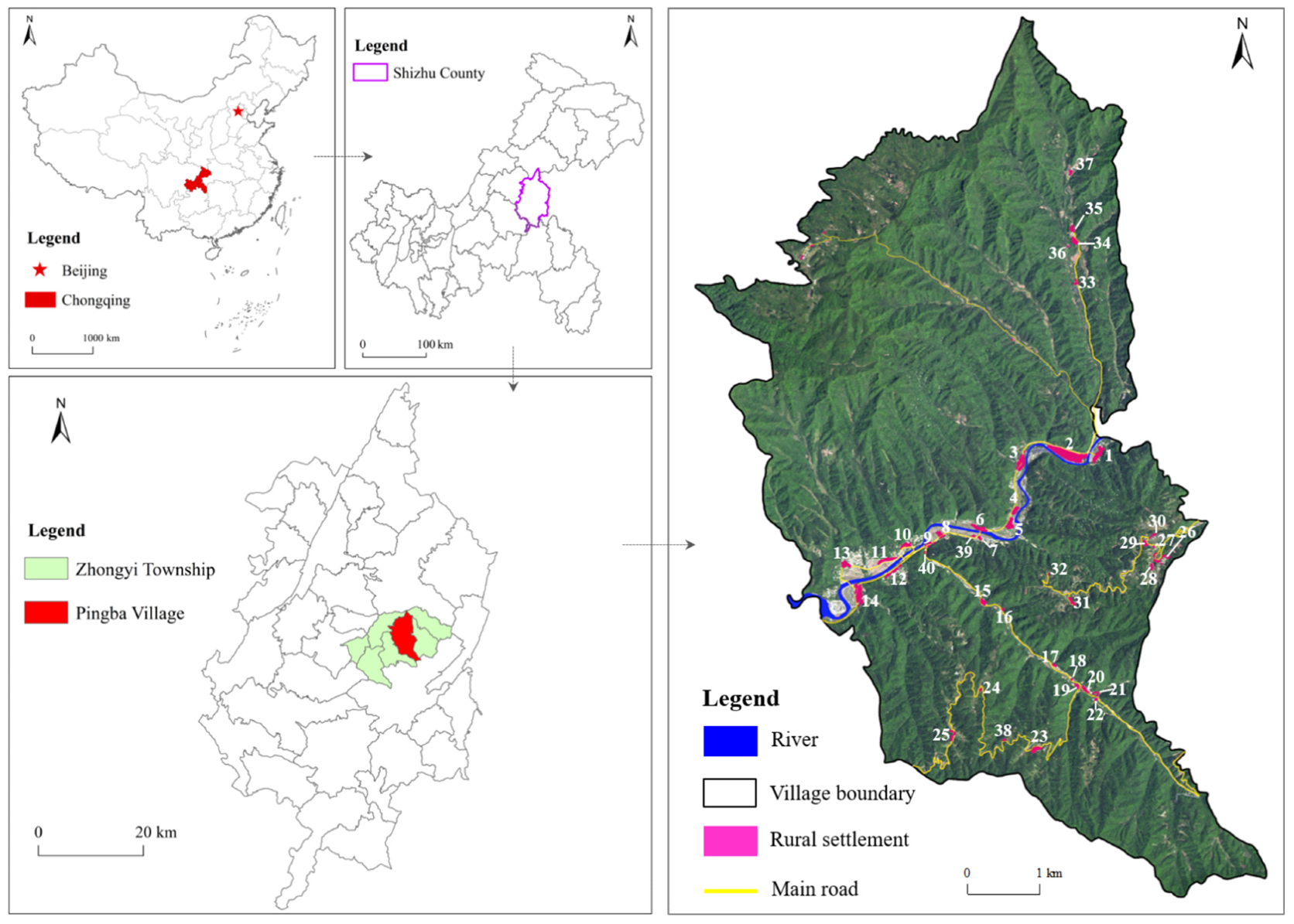
2.1. Study Area
2.2. Data Sources
2.3. Research Methods
2.3.1. Land Use Classification of Rural Settlements in the Study Area
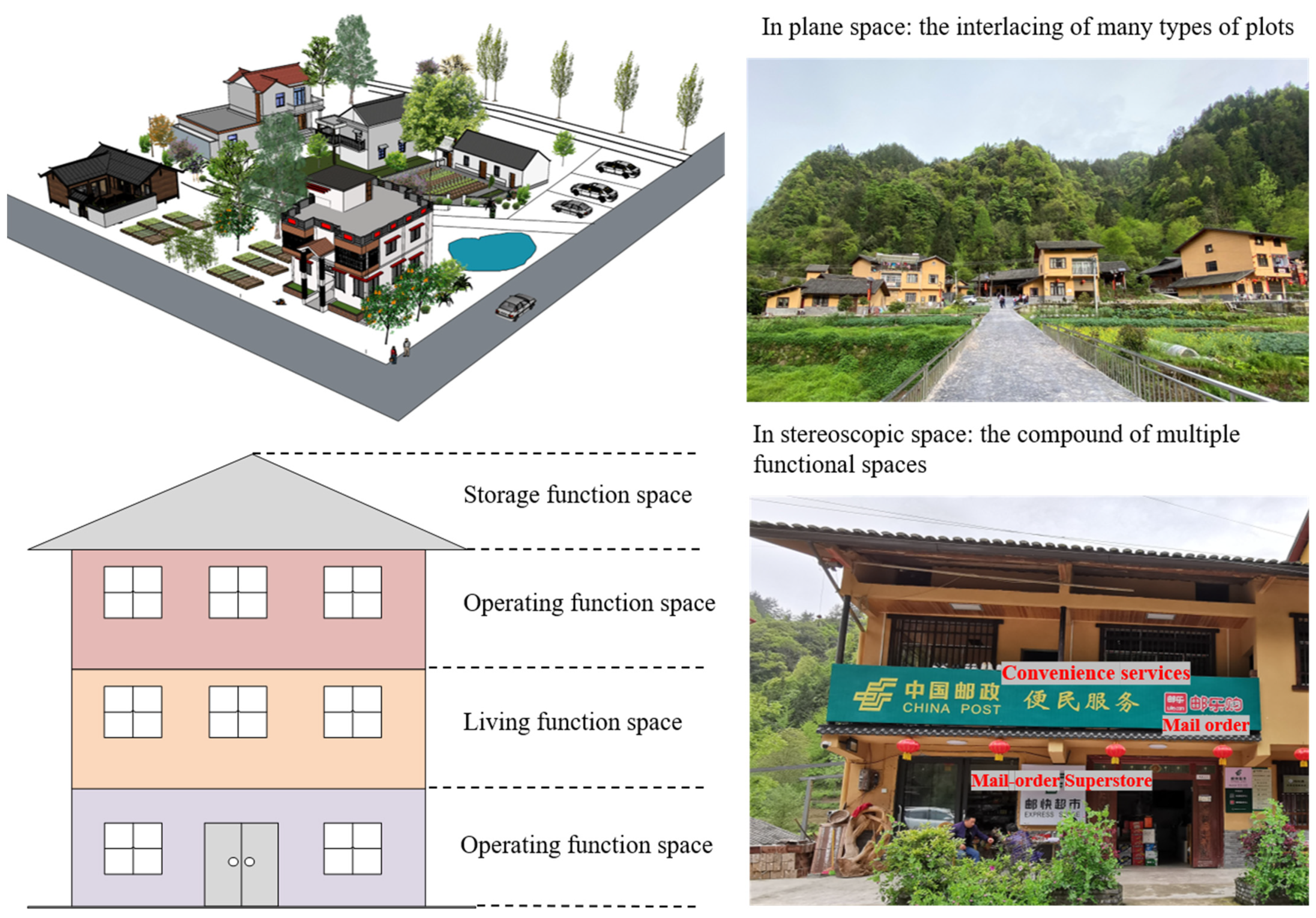
2.3.2. Connotation and Measurement System of MLU in Rural Settlements
- (1)
- Connotation of MLU in rural settlements
- (2)
- The Measurement System of MLU Levels
2.3.3. Measurement Methods and Models
- (1)
- Simpson diversity index
- (2)
- Vertical mixing index
- (3)
- Compactness model
- (4)
- Coupling coordination degree model
- (5)
- Composite index of MLU
2.3.4. Multiple Linear Regression Model
3. Results
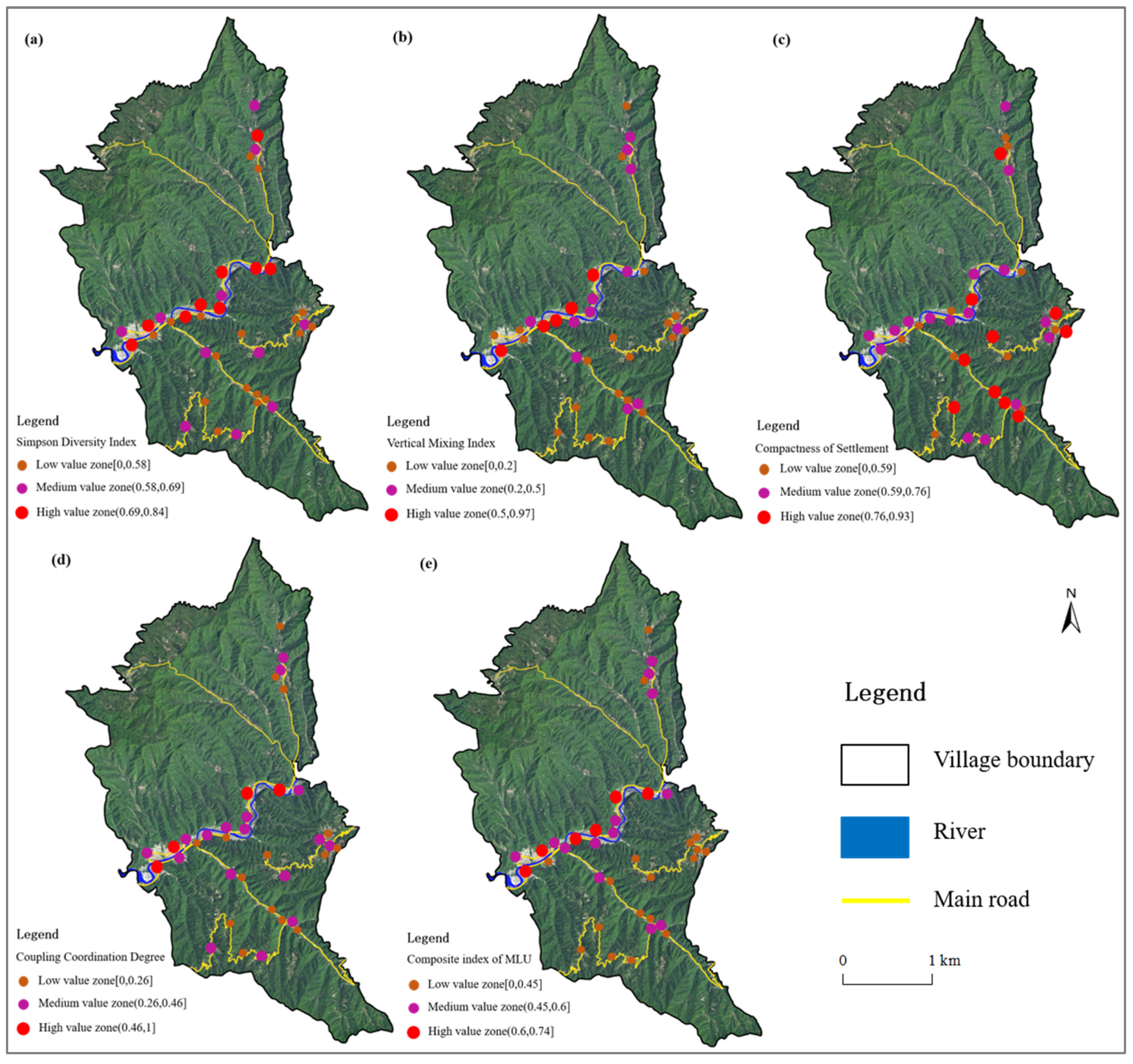
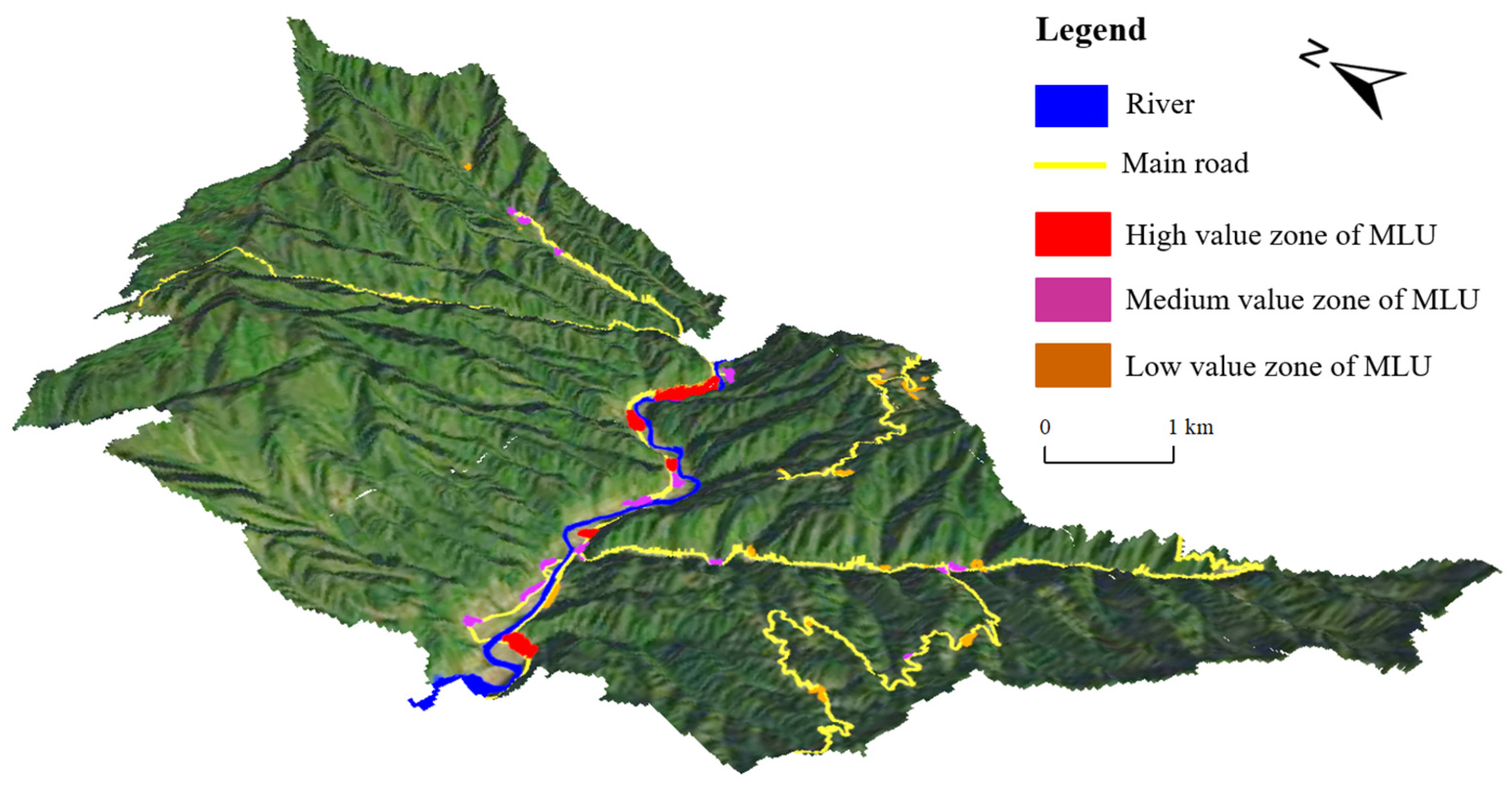
3.1. Level and Spatial Characteristics of MLU in Rural Settlements
3.2. Influencing Factors of MLU
- (1)
- Natural factors
- (2)
- Socioeconomic factors
- (3)
- Tourism resource factors
- (4)
- Policy factors
4. Discussion
4.1. Innovation and Deficiency
4.2. Policy Implications
4.2.1. Introduce the Concept of MLU into Village Planning
4.2.2. Optimize the Land Use Structure according to Local Conditions and Promote the Integrated Development of Primary, Secondary and Tertiary Industries in the Countryside
4.2.3. It Is Necessary to Scientifically Guide the Appropriate and Reasonable Clustering of Rural Settlements
5. Conclusions
- (1)
- MLU is an inevitable trend of social and economic transformation in rural areas. As an important part of rural regional systems, land use structures are spatial representations of human–environment interactions in rural areas. MLU is discussed from the perspective of the human–environment interaction within rural settlements. It is beneficial to expand and enrich the scientific connotation of rural area system theory and the multifunction theory of land use. In practice, guidance for the compilation and implementation of village planning, the adjustment and optimization of rural settlement land structure and the intensive use of rural land resources can be provided;
- (2)
- The degree of MLU in rural settlements in the study area was at a medium level, and there were significant differences in spatial patterns. Specifically, the percentages of rural settlements in the high-, medium- and low-value zones of MLU were 12.5%, 35% and 52.5%, respectively. The medium- and high-value zones of MLU were mainly located in the valley areas with low terrain and convenient transportation, while the low-value zones of MLU were mainly located in the high mountain areas with high terrain and inconvenient transportation;
- (3)
- The coupling interaction of multiple factors, such as the natural environment, resource endowment and local policy, profoundly affected the MLU level and its spatial differentiation pattern in the rural settlements. The differences in terrain, slope and other natural environments in the study area determined the level of MLU and the basic pattern of spatial differences. Social and economic factors, such as resident population and average household income, were key factors affecting the level of MLU. Tourism resources and homestead agglomeration policies can improve MLU levels;
- (4)
- In the future, the concept of MLU can be introduced into village planning to appropriately optimize the layout of rural settlements and promote the intensive use and high-quality development of rural land resources. Moreover, industrial development can drive the adjustment and optimization of land use patterns and structures, allowing the study area and other villages in the Three Gorges Reservoir area to develop rural industries according to local conditions and promote the integrated development of primary, secondary and tertiary industries. In addition, the utilization efficiency of land resources and public service resources can be improved by guiding the moderate and reasonable agglomeration of rural settlements, promoting MLU and optimizing the layout of land use.
Author Contributions
Funding
Institutional Review Board Statement
Informed Consent Statement
Data Availability Statement
Acknowledgments
Conflicts of Interest
References
- Zhang, B.; Qian, J.; Cai, W. Discussion on mixed use of rural residential land research framework. J. Nat. Resour. 2020, 35, 2929–2941. (In Chinese) [Google Scholar] [CrossRef]
- Zheng, H.; Huang, J.; Zhuo, Y.; Xu, Z. Research Progress on the Measurement of Mixed Land Use. China Land Sci. 2019, 33, 95–104. (In Chinese) [Google Scholar]
- Li, Y.; Westlund, H.; Zheng, X.; Liu, Y. Bottom-up initiatives and revival in the face of rural decline: Case studies from China and Sweden. J. Rural. Stud. 2016, 47, 506–513. [Google Scholar] [CrossRef]
- Liu, Y. Introduction to land use and rural sustainability in China. Land Use Policy 2018, 74, 1–4. [Google Scholar] [CrossRef]
- Su, K.; Hu, B.; Shi, K.; Zhang, Z.; Yang, Q. The structural and functional evolution of rural homesteads in mountainous areas: A case study of Sujiaying village in Yunnan province, China. Land Use Policy 2019, 88, 104100. [Google Scholar] [CrossRef]
- Jacobs, J. The Death and Life of Great American Cities: The Failure of Town Planning; Penguin Books: London, UK, 1961. [Google Scholar]
- Rowley, A. Mixed-use Development: Ambiguous concept, simplistic analysis and wishful thinking? Plan. Pract. Res. 1996, 11, 85–98. [Google Scholar] [CrossRef]
- Burton, E. Measuring urban compactness in UK towns and cities. Environ. Plan. B-Plan. Des. 2002, 29, 219–250. [Google Scholar] [CrossRef]
- Angotti, T.; Hanhardt, E. Problems and Prospects for Healthy Mixed-use Communities in New York City. Plan. Pract. 2001, 16, 145–154. [Google Scholar] [CrossRef]
- Shi, B.; Yang, J. Scale, distribution, and pattern of mixed land use in central districts: A case study of Nanjing, China. Habitat Int. 2015, 46, 166–177. [Google Scholar] [CrossRef]
- Raman, R.; Roy, U.K. Taxonomy of urban mixed land use planning. Land Use Policy 2019, 88, 104102. [Google Scholar] [CrossRef]
- Yoshida, T.; Tanaka, K. Land-use diversity index: A new means of detecting diversity at landscape level. Landsc. Ecol. Eng. 2005, 1, 201–206. [Google Scholar] [CrossRef]
- Comer, D.; Greene, J.S. The development and application of a land use diversity index for Oklahoma City, OK. Appl. Geogr. 2015, 60, 46–57. [Google Scholar] [CrossRef]
- Song, Y.; Merlin, L.; Rodriguez, D. Comparing measures of urban land use mix. Comput. Environ. Urban Syst. 2013, 42, 1–13. [Google Scholar] [CrossRef]
- Mavoa, S.; Boulange, C.; Eagleson, S.; Stewart, J.; Badland, H.M.; Giles-Corti, B.; Gunn, L. Identifying appropriate land-use mix measures for use in a national walkability index. J. Transp. Land Use 2018, 11, 681–700. [Google Scholar] [CrossRef]
- Abdullahi, S.; Pradhan, B.; Mansor, S.; Shariff, A.R.M. GIS-based modeling for the spatial measurement and evaluation of mixed land use development for a compact city. Gisci. Remote Sens. 2015, 52, 18–39. [Google Scholar] [CrossRef]
- Zhuo, Y.; Zheng, H.; Wu, C.; Xu, Z.; Li, G.; Yu, Z. Compatibility mix degree index: A novel measure to characterize urban land use mix pattern. Comput. Environ. Urban Syst. 2019, 75, 49–60. [Google Scholar] [CrossRef]
- Taleai, M.; Sharifi, A.; Sliuzas, R.; Mesgari, M. Evaluating the compatibility of multi-functional and intensive urban land uses. Int. J. Appl. Earth Obs. 2007, 9, 375–391. [Google Scholar] [CrossRef]
- Montejano Escamilla, J.; Caudillo Cos, C.; Silvan Cardenas, J. Contesting Mexico City’s alleged polycentric condition through a centrality-mixed land-use composite index. Urban Stud. 2016, 53, 2380–2396. [Google Scholar] [CrossRef]
- Nabil, N.A.; Eldayem, G.E.A. Influence of mixed land-use on realizing the social capital. HBRC J. 2015, 11, 285–298. [Google Scholar] [CrossRef] [Green Version]
- Williams, K. Sustainable cities: Research and practice challenges. Int. J. Urban Sustain. Dev. 2010, 1, 128–132. [Google Scholar] [CrossRef]
- Kim, D.; Jin, J. The Effect of Land Use on Housing Price and Rent: Empirical Evidence of Job Accessibility and Mixed Land Use. Sustainability 2019, 11, 938. [Google Scholar] [CrossRef] [Green Version]
- Wu, J.; Song, Y.; Liang, J.; Wang, Q.; Lin, J. Impact of Mixed Land Use on Housing Values in High-Density Areas: Evidence from Beijing. J. Urban Plan. Dev. 2018, 144, 05017019. [Google Scholar] [CrossRef]
- Koster, H.R.A.; Rouwendal, J. The Impact of Mixed Land Use on Residential Property Values. J. Reg. Sci. 2012, 52, 733–761. [Google Scholar] [CrossRef] [Green Version]
- Meng, Y.; Xing, H. Exploring the relationship between landscape characteristics and urban vibrancy: A case study using morphology and review data. Cities 2019, 95, 102389. [Google Scholar] [CrossRef]
- Jin, S.; Wang, D.; Su, B. Functional orientation and spatial siting of subway stations based on land potential and mixed land use. Ain Shams Eng. J. 2022, 13, 101733. [Google Scholar] [CrossRef]
- Hanni, C.K.; Kalyanpad, N.G.; Rao, K.V.K. Need for Sustainable Transport and Mixed Land Use: Findings from the 2008 and 2018 Travel Surveys. Transp. Res. Procedia 2020, 48, 3355–3364. [Google Scholar] [CrossRef]
- Brown, B.B.; Yamada, I.; Smith, K.R.; Zick, C.D.; Kowaleski-Jones, L.; Fan, J.X. Mixed land use and walkability: Variations in land use measures and relationships with BMI, overweight, and obesity. Health Place 2009, 15, 1130–1141. [Google Scholar] [CrossRef] [Green Version]
- Manaugh, K.; Kreider, T. What is mixed use? Presenting an interaction method for measuring land use mix. J. Transp. Land Use 2013, 6, 63–72. [Google Scholar] [CrossRef]
- Qu, Y.; Jiang, G.; Zhao, Q.; Ma, W.; Zhang, R.; Yang, Y. Geographic identification, spatial differentiation, and formation mechanism of multifunction of rural settlements: A case study of 804 typical villages in Shandong Province, China. J. Clean. Prod. 2017, 166, 1202–1215. [Google Scholar] [CrossRef]
- Ma, W.; Jiang, G.; Li, W.; Zhou, T. How do population decline, urban sprawl and industrial transformation impact land use change in rural residential areas? A comparative regional analysis at the peri-urban interface. J. Clean. Prod. 2018, 205, 76–85. [Google Scholar] [CrossRef]
- Zhang, B.; Jiang, G.; Cai, W.; Sun, P.; Zhang, F. Productive functional evolution of rural settlements: Analysis of livelihood strategy and land use transition in eastern China. J. Mt. Sci. 2017, 14, 2540–2554. [Google Scholar] [CrossRef]
- Gu, X.; Xie, B.; Zhang, Z.; Guo, H. Rural multifunction in Shanghai suburbs: Evaluation and spatial characteristics based on villages. Habitat Int. 2019, 92, 102041. [Google Scholar] [CrossRef]
- Zhu, X.; Wu, Y.; Weng, J.; Wang, Z.; Gao, W. Paradigm and spatial pattern analysis of island settlements based on mixed-use development: A case study of Zhoushan work-live community. Geogr. Res. 2017, 36, 1543–1556. (In Chinese) [Google Scholar]
- Wu, Y.; Wang, Z.; Yu, H.; Wang, K.; Chen, J. Evolution mechanism and spatial atlas analysis of“work-live integration”in rural areas: A case study of Bimen Village in Zhejiang. Geogr. Res. 2022, 41, 325–340. (In Chinese) [Google Scholar]
- Bailin, Z.; Zhaoying, W.; Minjie, Z. Characteristics and driving forces of the mixed use of rural settlement land. Trans. Chin. Soc. Agric. Eng. 2022, 38, 267–275. (In Chinese) [Google Scholar]
- Zheng, X.; Wu, B.; Weston, M.V.; Zhang, J.; Gan, M.; Zhu, J.; Deng, J.; Wang, K.; Teng, L. Rural Settlement Subdivision by Using Landscape Metrics as Spatial Contextual Information. Remote Sens. 2017, 9, 486. [Google Scholar] [CrossRef] [Green Version]
- Yang, R.; Liu, Y.; Long, H.; Qiao, L. Spatio-temporal characteristics of rural settlements and land use in the Bohai Rim of China. J. Geogr. Sci. 2015, 25, 559–572. [Google Scholar] [CrossRef] [Green Version]
- van Eck, J.R.; Koomen, E. Characterising urban concentration and land-use diversity in simulations of future land use. Ann. Reg. Sci. 2008, 42, 123–140. [Google Scholar] [CrossRef] [Green Version]
- Deng, Y.; Fu, X.; Zheng, W.; Zhang, H. Representation, measurement and attribution of spatial order of traditional villages in southern Hunan. Geogr. Res. 2021, 40, 2722–2742. (In Chinese) [Google Scholar]
- Zheng, H.; Wu, C.; Sheng, X. Review on the Research Context of Mixed Land Use and Systematic Framework Construction. Econ. Geogr. 2018, 38, 157–164. (In Chinese) [Google Scholar]
- Long, H.; Zhang, Y.; Tu, S. Rural vitalization in China: A perspective of land consolidation. J. Geogr. Sci. 2019, 29, 517–530. [Google Scholar] [CrossRef] [Green Version]
- He, T.; Qiao, W.; Jia, K.; Chai, Y.; Hu, Y.; Sun, P.; Wang, Y.; Feng, T. Selecting Rural Development Paths Based on Village Multifunction: A Case of Jingjiang City, China. Complexity 2020, 2020, 7590942. [Google Scholar] [CrossRef]
- Fan, Y.; Gan, L.; Hong, C.; Jessup, L.H.; Jin, X.; Pijanowski, B.C.; Sun, Y.; Lv, L. Spatial identification and determinants of trade-offs among multiple land use functions in Jiangsu Province, China. Sci. Total Environ. 2021, 772, 145022. [Google Scholar] [CrossRef] [PubMed]
- Chen, H.; Yang, Q.; Su, K.; Zhang, H.; Lu, D.; Xiang, H.; Zhou, L. Identification and Optimization of Production-Living-Ecological Space in an Ecological Foundation Area in the Upper Reaches of the Yangtze River: A Case Study of Jiangjin District of Chongqing, China. Land 2021, 10, 863. [Google Scholar] [CrossRef]
- Zhang, Y.; Wang, J.; Liu, Y. Regional function transformation and high-quality development path in Qinling-Daba Mountains of Shaanxi province. J. Nat. Resour. 2021, 36, 2464–2477. (In Chinese) [Google Scholar] [CrossRef]
- Yang, C.; Zeng, W.; Yang, X. Coupling coordination evaluation and sustainable development pattern of geo-ecological environment and urbanization in Chongqing municipality, China. Sustain. Cities Soc. 2020, 61, 102271. [Google Scholar] [CrossRef]
- Dai, L.; Zhan, Z.; Shu, Y.; Rong, X. Land Use Change in the Cross-Boundary Regions of a Metropolitan Area: A Case Study of Tongzhou-Wuqing-Langfang. Land 2022, 11, 153. [Google Scholar] [CrossRef]


| Data Types | Explanation | Data Source | |
|---|---|---|---|
| Geospatial data | Land use data | Using remote sensing images as the base map, the land use map within the rural settlements in the study area was mapped by field survey. | Field investigations |
| DEM | Digital elevation model; its resolution was 30 m. | The China Geospatial Data Cloud (http://www.gscloud.cn/home (accessed on 2 April 2021)) | |
| Administrative zoning | Included data such as the township boundaries of Shizhu County and the. administrative boundaries of Pingba Village. | Chongqing Shizhu County Planning and Natural Resources Bureau | |
| Remote sensing image data | Based on ArcGIS10.2 and QGIS3.22 software cropping. | The China National Platform for Common Geospatial Information Services (https://www.tianditu.gov.cn/ (accessed on 2 April 2021)) | |
| Settlement buildings | Included the structure, number of floors and internal functional space of the colony building. | Field investigations | |
| Socioeconomic data | Number of people in the settlement | Included the household and resident population of the settlement. | The villagers’ committee of Pingba Village |
| Agricultural and economic statistics report | Included data on land area, village collective income and village industrial development. | The villagers’ committee of Pingba Village | |
| Educational level of the farmers | The higher the education level of the farmers, the higher their knowledge and ability to accept new things. | Interviews with farmers | |
| Employment of the farmers | Included the employment status, nature of employment and income of farm households. | Interviews with farmers | |
| Annual household income of farm households | Refers to the total annual economic income of the household. | Interviews with farmers | |
| Land Types | Connotation |
|---|---|
| Residential land | Land for buildings that support the daily life, rest and residence of rural residents. |
| Planting land | Land used for planting vegetables, corn and other crops to meet the production and living needs of farmers. |
| Livestock land | Land used for breeding chickens, ducks, geese, pigs and other livestock. |
| Courtyard land | Open space for residents’ production, life, leisure and entertainment (such as the “Baba Dance”) and other functions. |
| Operating land | Land used for business activities such as homestays, farmhouses and canteens. |
| Storage land | Land used for storing farm tools, firewood, agricultural products and other daily sundries. |
| Transportation land | Roads used for transportation within the settlement area, excluding township roads and above. |
| Forestland | Forests that are closely related to the production and life of the residents within the settlement range. |
| Green land | Land for planting plants with greening and ornamental functions such as planting shrubs and flowers. |
| Industrial production land | Land for industrial productive activities such as breweries and edible mushroom processing plants. |
| Public service land | Land with public services such as village service centers, village post stations, and parking lots. |
| Residential—operating land | Plots of land with residential and business functions such as villagers using their own farmhouses to operate a farmhouse or snack shop. |
| Residential—storage land | Land on the same plot with dual functions of living and storage such as the storage of farm tools or other household objects in the basement or top floor of the farmhouse. |
| Forest—livestock land | Inner forest land of the settlement used for the farming of chickens, ducks, geese and other poultry. |
| Residential—public service —operating land | Land on the same plot with multiple functions of living, operating and public services, such as villagers using their own houses to operate farm entertainment or small stores as well as postal stations or express services. |
| Measure Dimension | Measure Basis | Connotation | Method | |
|---|---|---|---|---|
| Number and size | Plane Space | Diversity of land use | Drawing on the ecological biodiversity index [39], the area ratio of different land types is calculated. | Simpson diversity index |
| Stereo space | Drawing on the concept of floor area ratio, it is the average number of floors per unit of functional space [1]. | Vertical mixing index | ||
| Spatial structure | Compactness of rural settlements | Reflects the overall efficiency of the spatial layout of land use and indirectly reflects the degree of mixing [40]. | Compactness model | |
| Functional relationship | Coupling coordination | Reflects the degree of interaction and influence between different land types. The greater the degree of coupling coordination, the higher the level of mixed land use. | Coupling coordination degree model | |
| Primary Function Class | Secondary Function Classes and Assignment | Land Category |
|---|---|---|
| Production function | Strong production function (9) | Planting land, livestock land, operating land, industrial production land, residential—operating land and residential—public service—operating land. |
| Semi-production function (5) | Courtyard land, transportation land and forest—livestock land | |
| Weak production function (3) | Residential land, storage land, green land and residential—storage land | |
| Living function | Strong living function (9) | Residential land, residential—operating land, residential—public service—operating land and residential—storage land |
| Semi-living function (5) | Planting land, public service land, storage land, forest—livestock land, operating land, courtyard land and livestock land | |
| Weak living function (3) | Industrial production land and green land | |
| Ecological function | Strong ecological function (9) | Forest land and forest—livestock land |
| Semi-ecological function (5) | Green land | |
| Weak ecological function (3) | Planting land | |
| Cultural function | Strong cultural function (9) | Residential land, residential—operating land, residential—public service—operating land and residential—storage land |
| Semi-cultural function (5) | Courtyard land and Public service land | |
| Weak cultural function (3) | Operating land and industrial production land |
| Variable Category | Independent Variable | Variable Selection Basis |
|---|---|---|
| Population size | Resident population of rural settlements () | People are the main body of land use, and the resident population of the settlements is the key factor in the type, structure and function of land use. |
| Farmer characteristics | Number of households carrying out business activities () | Business activities, such as country houses and farmhouses, can promote the diversification of land use functions. |
| Education level above high school () | The higher the education level, the stronger the education level and the ability to accept new things. | |
| Average annual income of settlement households () | The income of farming households is an important indicator of the economic strength of the settlement, and the higher the income, the higher the ability to transform land use practices. | |
| Architectural features | The total number of floors of settlement buildings () | The number of building floors affects the size and type of functional space in the vertical direction. |
| Settlement building structure () | The building structure of a colony affects the number of floors and its internal environment and has a significant impact on the conduct of operational activities. It was quantified according to the level of quality: reinforced concrete structure = 9; brick and concrete = 7; brick and wood = 5; civil/stone and wood = 3; all wood = 1. |
| Settlement Number | Total Area of Land (m2) | Number of Land Types | Total Number of Floors | MLU Level | Settlement Number | Total Area of Land (m2) | Number of Land Types | Total Number of Floors | MLU Level |
|---|---|---|---|---|---|---|---|---|---|
| 1 | 11,967.94 | 7 | 38 | 0.54 | 21 | 1618.38 | 5 | 2 | 0.33 |
| 2 | 44,849.64 | 7 | 84 | 0.72 | 22 | 933.90 | 5 | 2 | 0.44 |
| 3 | 12,325.92 | 9 | 58 | 0.66 | 23 | 5804.95 | 5 | 6 | 0.4 |
| 4 | 5179.39 | 5 | 17 | 0.6 | 24 | 742.53 | 3 | 6 | 0.38 |
| 5 | 8434.08 | 8 | 16 | 0.57 | 25 | 3351.47 | 5 | 3 | 0.38 |
| 6 | 7151.07 | 8 | 18 | 0.59 | 26 | 3351.07 | 6 | 9 | 0.41 |
| 7 | 1406.07 | 4 | 11 | 0.51 | 27 | 2073.70 | 3 | 6 | 0.41 |
| 8 | 4370.29 | 7 | 18 | 0.71 | 28 | 2471.08 | 4 | 6 | 0.42 |
| 9 | 2190.04 | 3 | 18 | 0.51 | 29 | 3459.69 | 5 | 6 | 0.43 |
| 10 | 4783.27 | 5 | 12 | 0.51 | 30 | 1595.74 | 4 | 4 | 0.44 |
| 11 | 9150.38 | 7 | 12 | 0.5 | 31 | 3505.86 | 6 | 2 | 0.42 |
| 12 | 4692.58 | 4 | 3 | 0.35 | 32 | 225.30 | 2 | 2 | 0.24 |
| 13 | 6205.29 | 5 | 2 | 0.45 | 33 | 1640.68 | 3 | 8 | 0.51 |
| 14 | 14,784.26 | 9 | 44 | 0.74 | 34 | 5113.85 | 5 | 6 | 0.51 |
| 15 | 4025.41 | 5 | 12 | 0.5 | 35 | 3467.04 | 5 | 14 | 0.51 |
| 16 | 881.97 | 3 | 4 | 0.43 | 36 | 376.60 | 2 | 4 | 0.37 |
| 17 | 1446.64 | 4 | 5 | 0.43 | 37 | 1935.19 | 4 | 4 | 0.41 |
| 18 | 452.31 | 2 | 2 | 0.35 | 38 | 899.09 | 4 | 3 | 0.49 |
| 19 | 2325.08 | 4 | 8 | 0.53 | 39 | 892.62 | 4 | 2 | 0.37 |
| 20 | 3422.65 | 4 | 6 | 0.53 | 40 | 448.72 | 2 | 2 | 0.45 |
| Variable Category | Independent Variable | Standardized Coefficient | Significance | VIF |
|---|---|---|---|---|
| Population size | Resident population of rural settlements | 0.603 | 0.013 | 9.600 |
| Farmer characteristics | Number of households carrying out business activities | 0.087 | 0.092 | 5.996 |
| Education level above high school | 0.530 | 0.087 | 12.007 | |
| Average annual income of settlement households | 0.476 | 0.000 | 1.625 | |
| Architectural features | Total number of floors of settlement buildings | 0.307 | 0.327 | 9.176 |
| Settlement building structure | 0.269 | 0.011 | 2.331 |
Publisher’s Note: MDPI stays neutral with regard to jurisdictional claims in published maps and institutional affiliations. |
© 2022 by the authors. Licensee MDPI, Basel, Switzerland. This article is an open access article distributed under the terms and conditions of the Creative Commons Attribution (CC BY) license (https://creativecommons.org/licenses/by/4.0/).
Share and Cite
Chen, H.; Su, K.; Peng, L.; Bi, G.; Zhou, L.; Yang, Q. Mixed Land Use Levels in Rural Settlements and Their Influencing Factors: A Case Study of Pingba Village in Chongqing, China. Int. J. Environ. Res. Public Health 2022, 19, 5845. https://doi.org/10.3390/ijerph19105845
Chen H, Su K, Peng L, Bi G, Zhou L, Yang Q. Mixed Land Use Levels in Rural Settlements and Their Influencing Factors: A Case Study of Pingba Village in Chongqing, China. International Journal of Environmental Research and Public Health. 2022; 19(10):5845. https://doi.org/10.3390/ijerph19105845
Chicago/Turabian StyleChen, Hongji, Kangchuan Su, Lixian Peng, Guohua Bi, Lulu Zhou, and Qingyuan Yang. 2022. "Mixed Land Use Levels in Rural Settlements and Their Influencing Factors: A Case Study of Pingba Village in Chongqing, China" International Journal of Environmental Research and Public Health 19, no. 10: 5845. https://doi.org/10.3390/ijerph19105845
APA StyleChen, H., Su, K., Peng, L., Bi, G., Zhou, L., & Yang, Q. (2022). Mixed Land Use Levels in Rural Settlements and Their Influencing Factors: A Case Study of Pingba Village in Chongqing, China. International Journal of Environmental Research and Public Health, 19(10), 5845. https://doi.org/10.3390/ijerph19105845