Skip to Content
  • 1.7
    Impact Factor
  • 2.3
    CiteScore
  • 14 days
    Submission to First Decision
  • 4 days
    Acceptance to Publication

Birds

Birds is an international, peer-reviewed, open access journal on ornithology published quarterly online by MDPI.

Get Alerted

Add your email address to receive forthcoming issues of this journal.

All Articles (285)

  • Article
  • Open Access

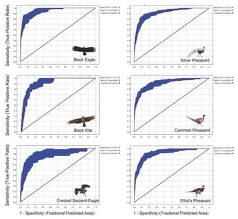
Understanding spatial distribution patterns is a key component in predicting community structural changes and preserving biodiversity. Within the subtropical forest ecosystems of China, the spatial interrelations between raptors and pheasants, and their respective roles and functions in community structures, remain inadequately studied. Through niche modeling, we examined the spatial distribution relationships between three large raptor species—the Black Eagle (Ictinaetus malaiensis), the Black Kite (Milvus migrans), and the Crested Serpent Eagle (Spilornis cheela) and three prevalent pheasant species—the Silver Pheasant (Lophura nycthemera), the Common Pheasant (Phasianus colchicus), and Elliot’s Pheasant (Syrmaticus ellioti). The results showed that the Black Eagle and Elliot’s Pheasant displayed localized distribution patterns, the Black Kite and Silver Pheasant demonstrated widespread distribution, and the Crested Serpent Eagle and Common Pheasant exhibited broader patchy distributions. Significant differences were observed in the potential suitable habitat areas among the raptor species pairs, with the Black Kite having the largest potential suitable habitat area and the Black Eagle the smallest. While the habitat area differences between the Silver Pheasant and Elliot’s Pheasant were not significant, both species significantly exceeded the Common Pheasant in potential suitable habitat area. The Silver Pheasant held the largest area within the raptors’ potential suitable habitat, and the Black Kite dominated within the pheasants’ habitats. These results indicated a higher sensitivity of the Black Eagle and Crested Serpent Eagle to human disturbances and potential coexistence among the pheasant species through spatial niche differentiation. The distribution patterns underscored the spatial interplay between raptors and pheasants, unveiling their individual survival strategies and functional roles within the ecosystem. This study offers insights into the ecological processes behind species distribution patterns.

Birds

8 October 2026
Study area, occurrence records and survey sites of the six focal species in Mingxi County, Fujian Province, southeastern China. (a) Regional location of Mingxi County in Fujian Province, southeastern China; the study area is highlighted in yellow. (b) Occurrence records of the Black Eagle, Black Kite, Crested Serpent Eagle, Silver Pheasant, Common Pheasant, and Elliot’s Pheasant overlaid on elevation. Different black symbols represent the six species, and each point represents a spatially unique occurrence record retained for MaxEnt modeling after spatial thinning. (c) Locations of the 38 field-survey sites (black triangles) overlaid on the 2020 land-use/land-cover map. Land-use codes are: 10, cultivated land; 20, forest land; 30, grassland; 60, water bodies; and 80, artificial surfaces.
  • Article
  • Open Access

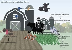
Rat control using anticoagulant rodenticides on livestock farms is a widely applied practice worldwide. Birds can be exposed to rodenticides through direct ingestion or secondary poisoning, resulting in mortality or sublethal health effects. While impacts on raptors and owls are well documented, potential effects on songbird communities in farmland settings have received limited empirical investigation. To address this gap, avifaunal surveys were conducted on 12 livestock farms in the Münsterland, Germany, during 2021–2022, comparing farms with and without rodenticide application to assess impacts on songbird and farmland bird communities. In addition, farm structures, such as the proportions of grassed areas and buildings, were quantified using spatial analysis (linear mixed-effects model). Farm structure showed patterns in bird abundance and community composition, with the proportion of buildings and grassed area showing the most notable associations with bird abundance and ground-nesting species respectively. Rodenticide application showed possible associations with the number of individual birds. However, none of those patterns reached statistical significance, and causal mechanisms remain unclear due to the observational design. Larger-scale studies are needed to assess population-level consequences and optimize rodenticide use alongside habitat management.

Birds

7 October 2026

Article thumbnail image
  • Article
  • Open Access

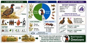
The winter diet of Black Francolin (Francolinus francolinus) is poorly documented in Totali Public Game Reserve, Pakistan. We examined crop contents from 24 legally harvested birds (14 males and 10 females) collected during 2022–2024. Thirty-three identifiable food taxa were recorded, comprising 22 plant and 11 animal taxa, together with unidentified plant and animal material. Dietary composition was quantified using frequency of occurrence, numerical abundance, mass percentage, and importance value (IV%). Plant material dominated numerically, with Poaceae (IV = 57.1%) and Fabaceae (IV = 25.7%) contributing most strongly among plant families, whereas Formicidae dominated the animal component (IV = 70.8%). Dietary indices were Shannon–Wiener H’ = 2.34, Simpson’s 1-D = 0.84, Pielou’s J’ = 0.67, and standardized Levins’ niche breadth B_sta = 0.16, indicating an uneven winter diet concentrated in a limited subset of resources despite the number of taxa recorded. Body mass, crop mass, and dry food mass did not differ significantly between sexes. Body mass was positively correlated with crop mass (r = 0.61, p = 0.001) and dry food mass (r = 0.59, p = 0.002). These findings provide a site-specific description of the winter diet and a baseline for future seasonal, multi-site, and resource-availability studies.

Birds

6 October 2026

Sampling sites within the Totali Public Game Reserve landscape, Buner district, Pakistan. The map shows sampling localities in relation to wasteland, natural grassland, forest cover, and built-up land-cover classes.
  • Article
  • Open Access

Bayesian Estimates of Collision Risk and Fatalities of Columbidae at Wind Turbines in the Isthmus of Tehuantepec

  • Carlos Adrián Sánchez-Caballero,
  • María A. Seba-Palacios and
  • Gustavo De La Cruz-Agüero
  • + 3 authors

Columbidae (pigeons and doves) are among the most abundant resident birds in agricultural landscapes and recorded as turbine fatalities, but they are rarely included in collision risk assessments. We evaluate nine years (2016–2024) of monitoring data from a wind farm in the Isthmus of Tehuantepec, Mexico, to estimate species-specific collision risk and fatalities for five species using a Bayesian Collision Risk Model (CRM). We integrated long-term visual census data, systematic carcass searches corrected for detection probability and carcass persistence, and biologically informed priors to estimate exposure rates, collision probabilities, and annual fatalities. Results revealed marked interspecific differences in collision risk that were not directly proportional to abundance. The most abundant species, White-winged Dove (Zenaida asiatica), showed high exposure but low collision probability. The opposite was found in less abundant species White-tipped Dove (Leptotila verreauxi). While overall estimated fatalities remained low, our model revealed a steady downward trend in absolute fatalities, projecting continued declines for 2025. Our findings highlight the importance of long-term monitoring and Bayesian approaches that incorporate uncertainty and species-specific traits. We provide parameterized priors that can be applied in future collision risk models and support the conclusion that wind farms may exhibit limited local mortality impacts on the studied avifauna.

Birds

3 October 2026

Location of the Bii Nee Stipa Wind Farm (purple outline) within the wind farm complex of the Isthmus of Tehuantepec, Oaxaca, Mexico. White and purple circles indicate turbines within the wind farm, whereas black circles identify the turbines selected for carcass searches. Locations of the surrounding wind farms were obtained from GeoComunes [26]. Vegetation cover within and surrounding the wind farm is also shown [27].

Highly Accessed Articles

News & Conferences

Latest Issues

Open for Submission

Journal Sections

XFacebookLinkedIn
Birds - ISSN 2673-6004