Skip to Content

Quaternary

Quaternary is an international, peer-reviewed, open access journal that covers all aspects within quaternary science, embracing the whole range of scientific fields related to geological, geographical, biological, physical, chemical, environmental and human sciences. The journal is published bimonthly online by MDPI.

Get Alerted

Add your email address to receive forthcoming issues of this journal.

All Articles (462)

  • Article
  • Open Access

We investigated the lithology and tephra of the 87-metre-long drill core (WD1) from the Walsdorfer maar (Eifel, Germany) in order to reconstruct the sequence of volcanic activity and its integration into palaeoclimatic developments between Marine Isotope Stage (MIS) 7 and MIS 6. Based on tephra counts, mineralogical and geochemical analyses, we have identified 11 primary tephra layers in the WD1 core that have not previously been described in the Eifel, with an age range of approximately 196–158 ka, alongside 13 reworked tephra layers, particularly in the older part of the core. Leucite was detected in the important marker tephra Hüttenberg Tephra (HBT) at 215 ka and Glees Tephra (GLT) at 151 ka. The basal Walsdorfer Maar Tephra (WDT) dates the outbreak to 217,843 years ago. Our results thus extend the existing ELSA–23–Tephra–Stack for the period 220–130 ka. The results for organic components show that, during the period 215–185 ka (MIS 7c–7a), a predominantly boreal forest consisting mainly of thermophilic deciduous species was established, whilst in the range of 170–152 ka, during the earlier half of MIS 6, hardly any pollen and less organic material have been preserved. The data point to changes in productivity and vegetation dynamics, which are reflected in the composition of the organic matter. The liptinite-rich intervals with higher fluorescence primarily characterise warmer subphases within MIS 7, whereas cool-humid conditions during the glacial MIS 6 favoured the formation of huminite-rich peats. The presence of calcareous layers in the 200–190 ka range indicates formerly wet conditions, suggesting MIS 7a. Palaeotemperature calibrations were analysed by brGDGT and provide the temperature of MAF comparable to Holocene levels. The data from the WD1 core (Eifel) confirm the climatic conditions during MIS 7a as inferred from other European archives, add a new region to the picture, and, because of their high resolution, enable the identification of climatic fluctuations that could not be detected in previous studies. We reconstruct a tephrostratigraphic chronology as well as the palaeoclimatic evolution of the period 220–132 ka in the Walsdorfer maar.

Quaternary

29 September 2026
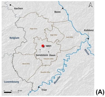
(A) Location of the Eifel in western Germany, showing various subdivisions, the analysed drill core of the Walsdorfer maar (WD1), as well as the neighbouring countries. In addition to rivers of significance for the mountainous terrain, six localities are marked. (B) Geological context of the West Eifel Volcanic Field within the German Eifel, showing pyroclastic, effusive and pre-Quaternary volcanic units against the sedimentary and unconsolidated basement, and the analysed drill core (WD1). Maps created using QGIS (version 3.40.2): scale 1:1,000,000, EPSG:3857; basemap: elevation hillshade derived from the Copernicus DEM GLO-30 (© European Union, Copernicus) via the QGIS Contour Lines plugin; data: WD1 drill core by F. Sirocko, F. Schenk; localities: Wikidata, CC0 (Public Domain), via http://w.wiki/FcVR (accessed on 14 September 2026); rivers: Rhine: OSM relation 123924, Moselle: OSM relation 390416, OpenStreetMap contributors, ODbL 1.0; countries: EuroGeographics for the administrative boundaries, CC BY 4.0, via Eurostat; Eifel area: OSM relations 123924, 390416, 408622, 3646368, 10601027, 334377, 16742974, OpenStreetMap contributors, ODbL 1.0; geology: Geologische Übersichtskarte 1:250,000 (GÜK250), petrography base layers, classified via https://github.com/fionaschenk/petrography-classification (accessed on 15 September 2026); data source: GÜK250, © BGR, Hannover, 2026 (modified) via http://services.bgr.de/arcgis/rest/services/geologie/guek250/MapServer (accessed on 14 September 2026), usable under the German Federal Ordinance on the Conditions for Use for the Provision of Spatial Data (GeoNutzV)—License: CC BY 4.0, Fiona Schenk.
  • Article
  • Open Access

The Jiali Fault Zone is one of the key active tectonic structures along the southeastern margin of the Tibetan Plateau and has been widely regarded as the southern boundary structure accommodating the lateral extrusion and eastward escape of the Qiangtang and Sichuan–Yunnan blocks. Assessing its Quaternary activity is important for understanding the tectonic evolution and deformation partitioning of southeastern Tibet. This study focuses on the Yi ong–Zayu segment of the Jiali Fault Zone, using high-resolution stereo imagery from the GF-7 satellite. The ERDAS dense image matching method was applied to generate a dense point cloud and a 0.8 m high-resolution digital surface model. Combining regional remote sensing image interpretation with field surveys, we characterize the geomorphic expression and Quaternary deformation of the Yi ong–Zayu segment. The results show no significant surface displacement along the fault. The alluvial fans are largely preserved, and there are no continuous, co-directional offsets along the tributary channels or river systems. In particular, clear evidence for Quaternary right-lateral strike-slip displacement is absent. Instead, localized normal faults with NW–SE to approximately E–W strikes occur in limited areas. This study focuses on the Yi ong–Zayu segment of the Jiali Fault Zone, using high-resolution stereo imagery from the GF-7 satellite. The ERDAS dense image matching method was applied to generate a dense point cloud and a 0.8 m high-resolution digital surface model. Combining regional remote sensing image interpretation with field surveys, we characterize the geomorphic expression and Qua-ternary deformation of the Yi ong–Zayu segment. The results show no significant surface displacement along the fault. The alluvial fans are largely preserved, and there are no continuous, co-directional offsets along the tributary channels or river systems. In particular, clear evidence for Quaternary right-lateral strike-slip displacement is absent. Instead, localized normal faults with NW–SE to approximately E–W strikes occur in limited areas. These findings indicate that the Yi ong–Zayu segment experienced limited Quaternary deformation and has not functioned as a major boundary strike-slip fault since the Quaternary. Instead, it has been influenced by the rotational extrusion of the southeastern Tibetan Plateau, exhibiting characteristics of regional extensional tectonic activity. The present-day deformation is consistent with a rotation–extrusion model, in which crustal material undergoes clockwise rotation around the eastern Himalayan syntaxis and gradually transfers southeastward toward the Sichuan–Yunnan region due to the obstruction of the rigid Sichuan Basin.

Quaternary

18 September 2026

(a) Regional overview map; (b) Seismogeological map of the Yi ong-Zayu segment of the Jiali Fault Zone. The earthquake catalog is sourced from USGS, DEM elevation data is derived from Aster DEM with a 30 m resolution, and the fault locations from previous studies are based on [5].
  • Article
  • Open Access

Hidden Sea Level Effect on Mediterranean Outflow Proxies

  • Javier P. Tarruella and
  • Francisco J. Sierro

Contourite activity in the Gulf of Cadiz (GoC) is dominated by the precession-driven, ~20 ka cyclicity of the Mediterranean circulation and Mediterranean Outflow Water (MOW). Grain size distributions in contourites are strongly influenced by bottom current speed and are therefore widely used in the GoC to trace past MOW strength changes. However, the influence of sea level changes, driven by the expansion and retreat of ice sheets following the “100 ka world”, is superimposed to some extent through variations in terrigenous sediment supply. Despite the numerous high-resolution proxy records of MOW strength, the influence of glacial–interglacial relative sea level (RSL) changes on these records remains unclear. By analyzing the correlation between sortable silt grain size parameters at IODP U1389, we isolated the grain size variability that is not controlled by bottom current (MOW) sorting. This residual grain size variability closely follows the RSL curves and accounts for the higher sortable silt content observed during RSL lowstands. We suggest that the RSL-induced shoreline proximity contributes to a coarser terrigenous hemipelagic/suspended load component in contourites, increasing silt content. Furthermore, we present novel outflow proxy records based on the specific mineral components by using mica (allogenic) and pyrite (authigenic) counts.

Quaternary

18 September 2026

The oceanographic setting of IODP Site U1389 (red star) in the middle slope of the Gulf of Cadiz, ~150 km away from the Atlantic–Mediterranean gateway. White arrows: The Mediterranean outflow pathway. The −120 m isobath is represented to illustrate the potential glacial–interglacial shoreline displacement. Note that during glacial maxima, distance to the coast can reach half of that of today. The main rivers of the GoC are represented in blue. Bathymetry data from [31].
  • Article
  • Open Access

The identification and interpretation of bone surface modifications (BSM) are central to reconstructing early hominin behavior, yet recent shifts by some researchers toward metric quantification face significant epistemological and statistical challenges. This paper critically evaluates the “metric method” proposed by Keevil/Pante et al., arguing that its reliance on continuous, ratio-scale measurements is fundamentally undermined by effector variance—the inherent dimensional mismatch between experimental tools and those in the (assemblage-specific) archaeological record. I demonstrate through statistical analysis that the method’s use of quadratic discriminant analysis (QDA) is compromised by severe multicollinearity (VIF > 5), resulting in unstable models that fail to generalize to fossil contexts, as exemplified by the problematic interpretations of the Grăunceanu (Romania) assemblage. Furthermore, I deconstruct recent critiques against the application of machine learning (ML) in taphonomy, clarifying misconceptions regarding Wolpert’s “no free lunch” theorem and rebutting allegations of data leakage. I contend that ML algorithms, when properly integrated with high-resolution categorical data, provide a more robust and accurate framework for classification of taphonomic datasets. By exposing these methodological biases, I propose a new paradigm for BSM analysis that prioritizes systemic hypothesis testing, objective data generation, and empirical testing/refutation models based on original datasets over speculative arguments and strict metric quantification.

Quaternary

17 September 2026

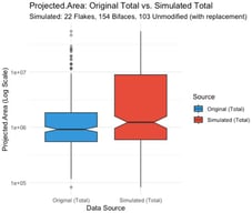
Comparison of Projected.Area values (example of selected variable from Keevil et al.’s dataset) between the original dataset (all tool types combined) and a simulated dataset generated through sampling with replacement (22 flake tools, 154 biface tools, and 103 unmodified tools). Boxplots represent the median and interquartile range, with notches indicating approximate 95% confidence intervals around the median and whiskers extending to 1.5× the interquartile range. Individual outliers are displayed with reduced opacity. The y-axis is shown on a logarithmic scale to accommodate the wide range of area values and facilitate visual comparison between distributions.

Highly Accessed Articles

News & Conferences

Latest Issues

Open for Submission

Journal Sections

Taphonomy and Palaeoecology of Quaternary Vertebrates
Reprint

Taphonomy and Palaeoecology of Quaternary Vertebrates

Advances in Fossil and Experimental Studies
Editors: Juan Rofes, Janine Ochoa, Emmanuelle Stoetzel
Mammals Biochronology and Paleoecology of the Euro-Mediterranean Quaternary
Reprint

Mammals Biochronology and Paleoecology of the Euro-Mediterranean Quaternary

Editors: Alessio Iannucci, George E. Konidaris, Dimitris S. Kostopoulos, Joan Madurell-Malapeira, Raffaele Sardella
XFacebookLinkedIn
Quaternary - ISSN 2571-550X