



-
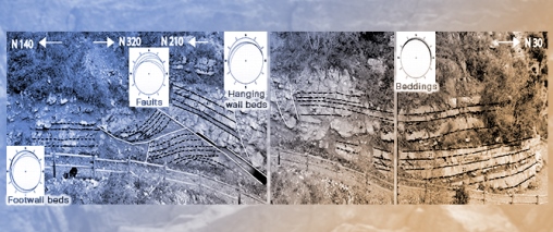
Deformation Style and Structural Architecture of Faulted Well-Layered Platform Carbonates, Raparo Mt., Southern Italy -
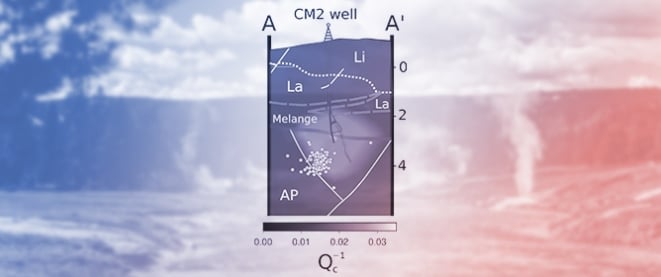
HVSR Processing for Creep-Capable Fault Identification at Etna -
Absorption and Scattering Signature of Fluid-Injected, Hydrocarbon, and Low-to-Medium Enthalpy Geothermal Reservoirs -
The Mineral Chemistry Networks of Tin and Tungsten Reflect Metallogenic Events of the Mesozoic -
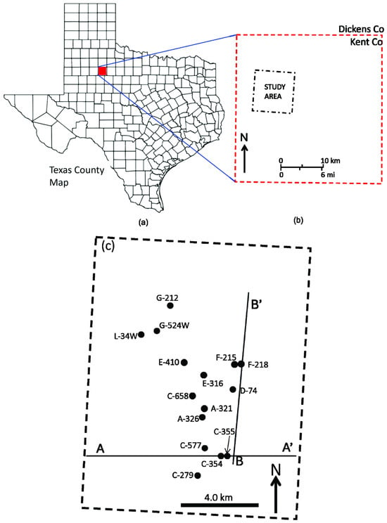
A Geophysical Survey of the Kentland Crater Formation
Journal Description
Geosciences
Geosciences
is an international, peer-reviewed open access journal on geoscience, future earth and planetary science, published monthly online by MDPI. The European Federation of Geologists (EFG) is affiliated with Geosciences and its members receive a discount on the article processing charges.
- Open Access— free for readers, with article processing charges (APC) paid by authors or their institutions.
- High Visibility: indexed within Scopus, ESCI (Web of Science), GeoRef, Astrophysics Data System, and other databases.
- Journal Rank: CiteScore - Q2 (General Earth and Planetary Sciences)
- Rapid Publication: manuscripts are peer-reviewed and a first decision is provided to authors approximately 22.7 days after submission; acceptance to publication is undertaken in 4.6 days (median values for papers published in this journal in the first half of 2026).
- Recognition of Reviewers: reviewers who provide timely, thorough peer-review reports receive vouchers entitling them to a discount on the APC of their next publication in any MDPI journal, in appreciation of the work done.
- Journal Cluster of Geospatial and Earth Sciences: Remote Sensing, Atmosphere, Geosciences, Climate, Quaternary, Earth, Geographies, Geomatics, Meteorology and Fossil Studies.
Impact Factor:
2.3 (2025);
5-Year Impact Factor:
2.6 (2025)
Latest Articles
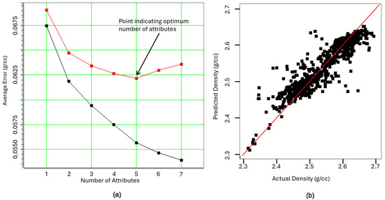
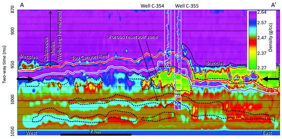
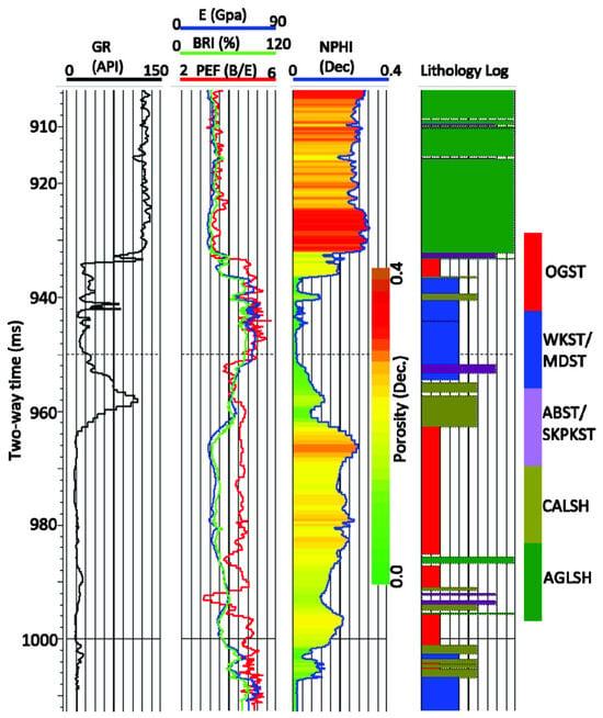
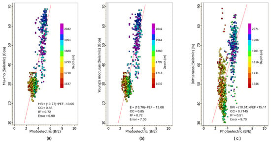
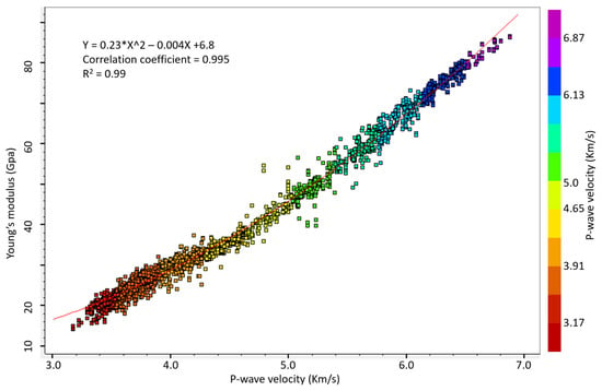
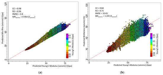
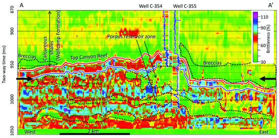
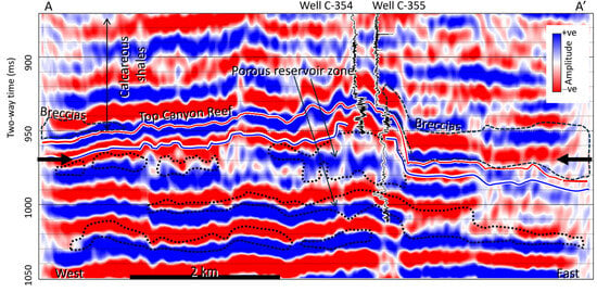
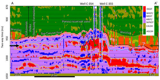
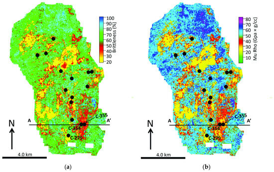
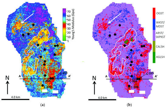
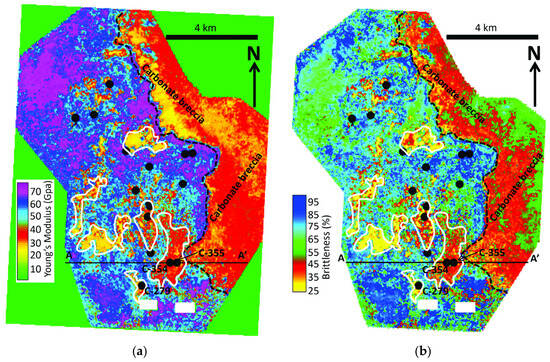
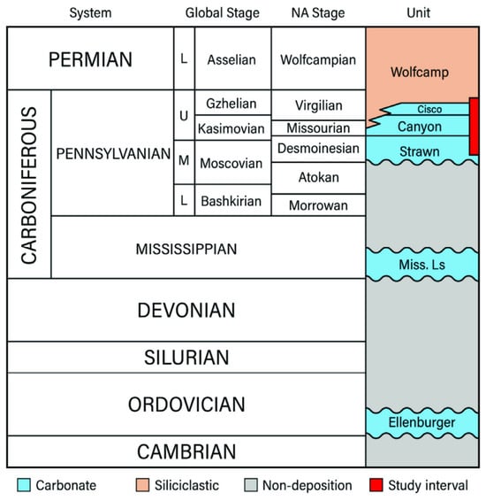
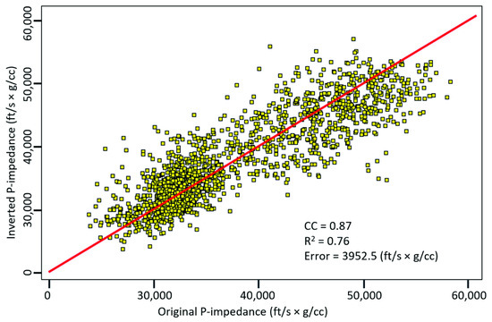
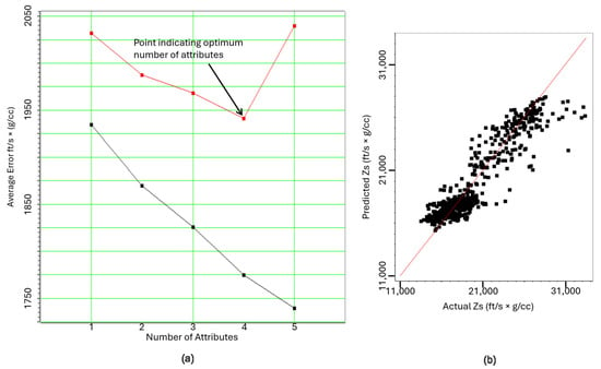
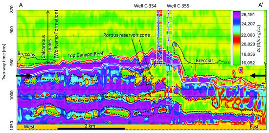
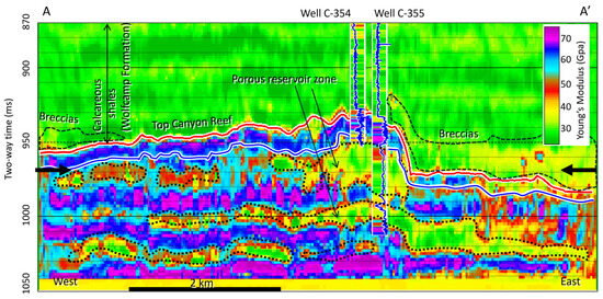
Poststack Seismic Geomechanical Property Evaluation of the Pennsylvanian Strawn–Canyon Group in Salt Creek Field, Midland Basin, Kent County, West Texas
Geosciences 2026, 16(8), 324; https://doi.org/10.3390/geosciences16080324 (registering DOI) - 9 Aug 2026
Abstract
Geomechanical properties of rock are essential components in designing hydraulic fracturing procedures. Although ultrasonic measurement methods are usually utilized to obtain static geomechanical properties of rocks in the laboratory, they are limited to borehole locations. To obtain spatial distribution of these properties, a
[...] Read more.
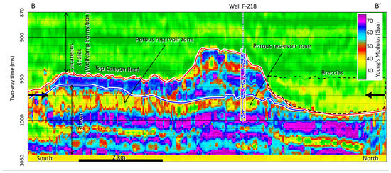
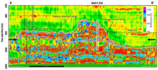
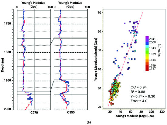
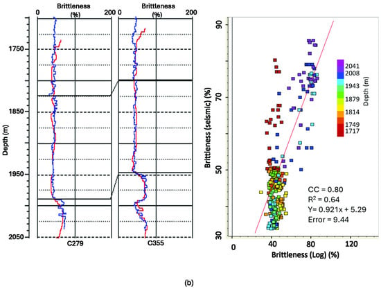
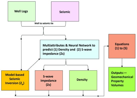
Geomechanical properties of rock are essential components in designing hydraulic fracturing procedures. Although ultrasonic measurement methods are usually utilized to obtain static geomechanical properties of rocks in the laboratory, they are limited to borehole locations. To obtain spatial distribution of these properties, a 3D prestack seismic inversion process is employed to derive them dynamically. However, 3D prestack seismic datasets are less readily available compared to 3D poststack seismic. We present a methodology that integrates 3D poststack seismic and wireline log data using a machine learning workflow to compute the dynamic geomechanical properties, namely Young’s modulus (E), Mu-Rho (MR), and brittleness (BRI) volumes, and generate crossplots to characterize the Salt Creek carbonate reservoir in the Midland Basin, Kent County, Texas. Our results show that: (1) Based on the comparison of seismically (dynamically) derived E and BRI maps with litho-facies maps, the zones with the highest porosity (oolites) are characterized by low E and low BRI. (2) Each of these properties is linearly related to the photoelectric factor (PEF) log, which can indicate porosity and calcite richness within a mixed carbonate–siliciclastic system. (3) In a mixed carbonate and siliciclastic system, geomechanical properties, especially E, can be used to identify rigid rock layers within the reservoir and deduce possible lithologies. Finally, when prestack seismic data are unavailable, our workflow offers a quick and inexpensive method to generate dynamic geomechanical property maps to characterize hydrocarbon reservoirs using poststack seismic data and well logs.
Full article
(This article belongs to the Section Geomechanics)
►
Show Figures
Open AccessArticle
An Integrated Geospatial Framework for Geological and Remote Sensing Analysis in Rare Metal Exploration: Eastern Kazakhstan
by
Yerkebulan Bekishev, Marzhan Rakhymberdina, Eugene Levin, Roman Shults and Zhanna Assylkhanova
Geosciences 2026, 16(8), 323; https://doi.org/10.3390/geosciences16080323 (registering DOI) - 8 Aug 2026
Abstract
►▼
Show Figures
Rare metal exploration increasingly relies on the integration of heterogeneous geological datasets and advanced analytical methods to improve the efficiency and reliability of mineral prospecting. This study presents the development of a web-based Geographic Information System, Geospatial Information System for Optimized Rare Metal
[...] Read more.
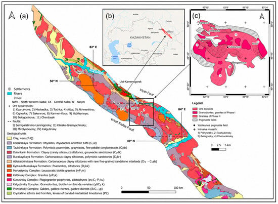
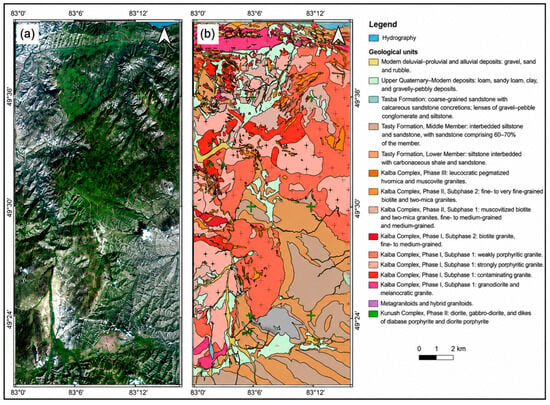
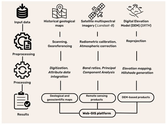
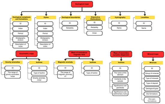
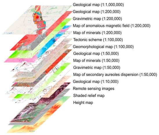
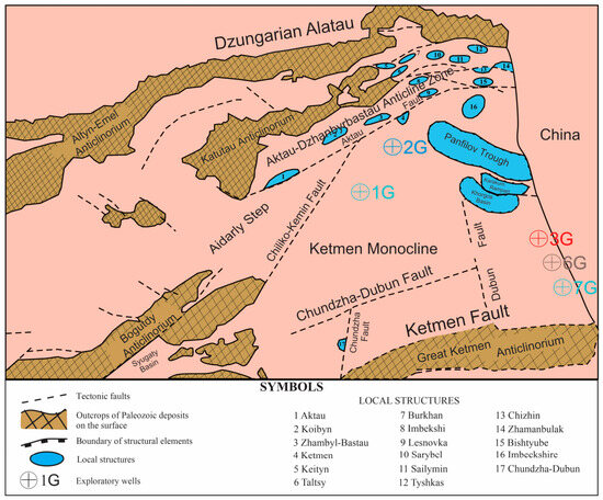
Rare metal exploration increasingly relies on the integration of heterogeneous geological datasets and advanced analytical methods to improve the efficiency and reliability of mineral prospecting. This study presents the development of a web-based Geographic Information System, Geospatial Information System for Optimized Rare Metal Exploration in Eastern Kazakhstan (GISORMEK), using the central part of the Kalba–Narym rare-metal belt (Eastern Kazakhstan) as a case study. A comprehensive geospatial database was developed through the digitization of archival geological maps and the integration of geological, geochemical, tectonic, geophysical, geomorphological, and mineral occurrence datasets. To complement historical mapping data, Landsat-8 multispectral imagery was incorporated to improve lithological discrimination and identify hydrothermal alteration zones. Two remote sensing techniques were applied: Principal Component Analysis (PCA) for lithological mapping and enhancement of geological features, and band ratio (BR) analysis for the calculation of geological spectral indices, including the iron oxide index and the hydroxyl-bearing (Al–OH) mineral index. The resulting spectral indices were subsequently integrated to generate a predictive hydrothermal alteration map. GISORMEK integrates historical and contemporary datasets within a unified web-GIS framework, ensuring spatial consistency, reproducibility, and accessibility. The proposed framework enhances the interpretation of the mineralization potential of the Kalba–Narym region and provides geospatial platform for supporting rare metal exploration and future mineral prospectivity assessments.
Full article

Figure 1
Open AccessArticle
Dynamic Evolution of the Lacul Fără Nume Landslide Dam in the Eastern Carpathians: A Rare Recurrent Geomorphic System Characterized by Repeated Damming–Breaching Cycles
by
Thomas Wolfert, Alin Mihu-Pintilie, Cristian Constantin Stoleriu and Vasile Jitariu
Geosciences 2026, 16(8), 322; https://doi.org/10.3390/geosciences16080322 (registering DOI) - 8 Aug 2026
Abstract
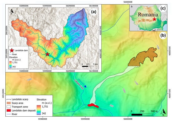
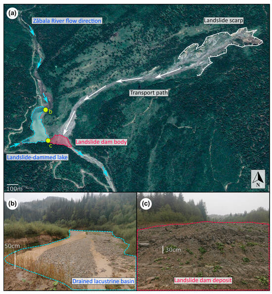
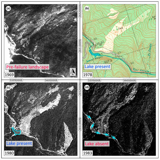
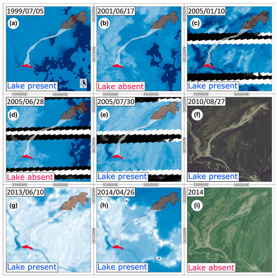
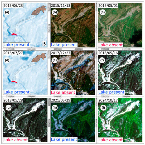
The Lacul fără nume landslide dam in the Vrancea Mountains (Romania) represents a unique example of a dynamic landslide dam system characterized by recurrent damming–breaching cycles. Through the combined use of remote sensing, field investigations, and historical reconstruction, eight such cycles were documented
[...] Read more.
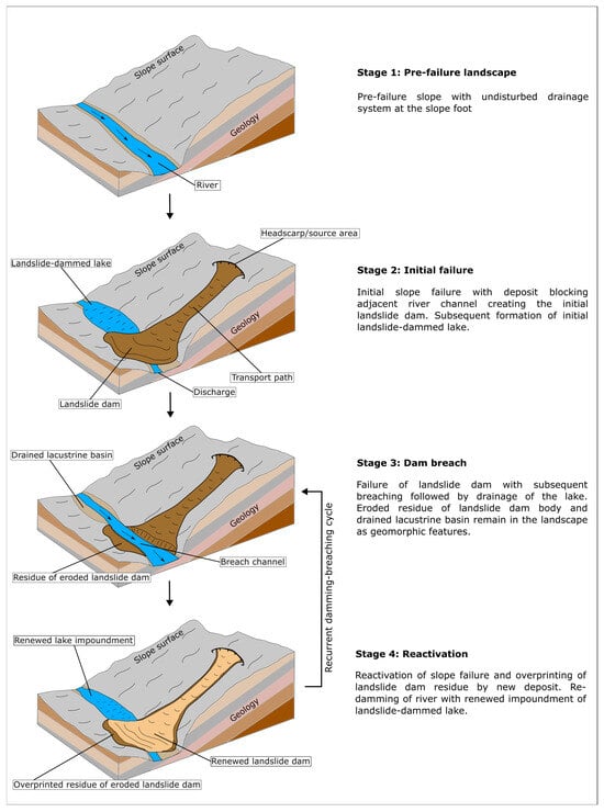
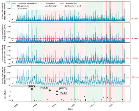
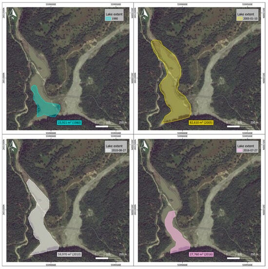
The Lacul fără nume landslide dam in the Vrancea Mountains (Romania) represents a unique example of a dynamic landslide dam system characterized by recurrent damming–breaching cycles. Through the combined use of remote sensing, field investigations, and historical reconstruction, eight such cycles were documented over a period of 49 years. To the best of current knowledge, this is one of the few documented landslide dams reported in the scientific literature that exhibits frequent damming–breaching episodes involving repeated dam failure, renewed slope instability, and subsequent re-damming with renewed lake impoundment over comparatively short timescales. The observed persistence and spatial extent of the associated lake are highly variable, ranging from 12 days to almost 10 years and from 23,920 m2 to 82,610 m2, respectively. Antecedent precipitation was frequently elevated prior to lake state transitions, but a seasonally constrained Monte Carlo analysis showed no significant departure from the climatic background, while numerous intense rainfall periods occurred without documented transitions. Similarly, no systematic temporal association was identified between recurrent lake state transitions and regional seismicity, although the initial dam formation coincided with the 1977 Mw 7.4 Vrancea earthquake. These findings suggest that precipitation conditions and seismicity alone cannot explain the recurrent damming and drainage, which likely result from interactions between hydrometeorological forcing, geomorphic processes, and human influences. Taken together, the results and the proposed conceptual model demonstrate that debris-flow-generated landslide dams can evolve into persistent and dynamic geomorphic systems capable of posing recurring hazards over multiple decades.
Full article
(This article belongs to the Special Issue New Advances in Landslide Mechanisms and Prediction Models)
►▼
Show Figures

Figure 1
Open AccessArticle
Mapping Approaches for Assessing Regional Soil Liquefaction Potential: A Comparative Assessment
by
Yan Zhang, Su He, Miaojun Sun, Bohan Zhou, Mengfen Shen and Honglei Sun
Geosciences 2026, 16(8), 321; https://doi.org/10.3390/geosciences16080321 - 7 Aug 2026
Abstract
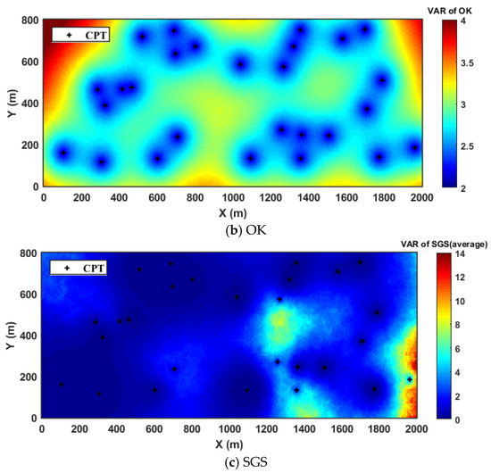
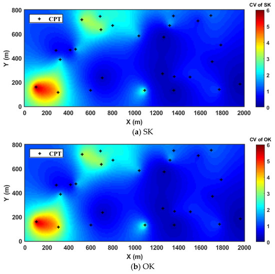
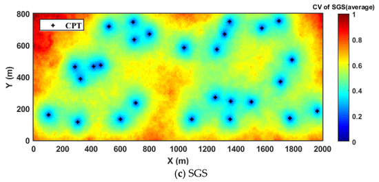
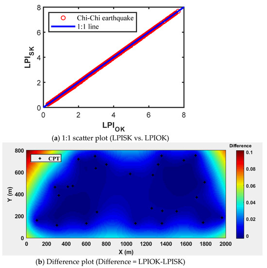
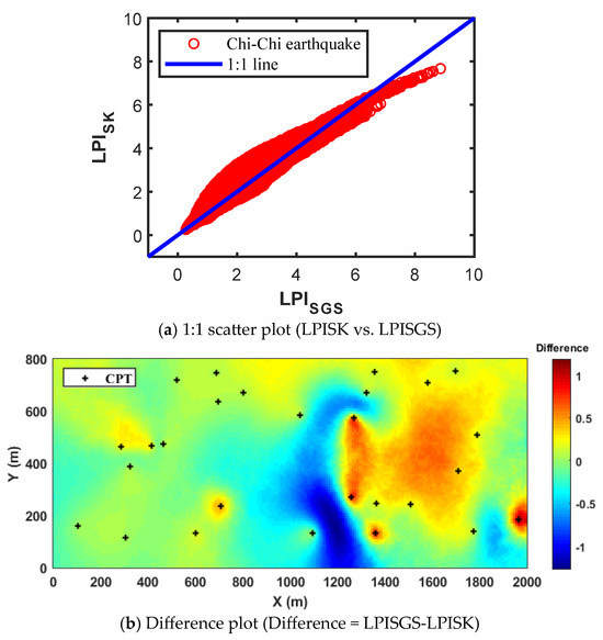
Seismic liquefaction poses a significant threat to infrastructure and human safety, making accurate regional-scale hazard assessment essential for effective disaster mitigation. This study systematically compares simple kriging (SK), ordinary kriging (OK), and sequential Gaussian simulation (SGS) for liquefaction potential mapping using a case
[...] Read more.
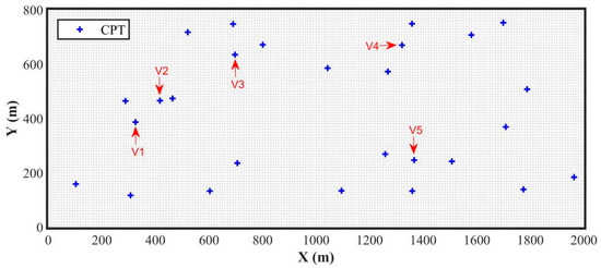
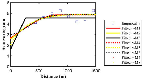
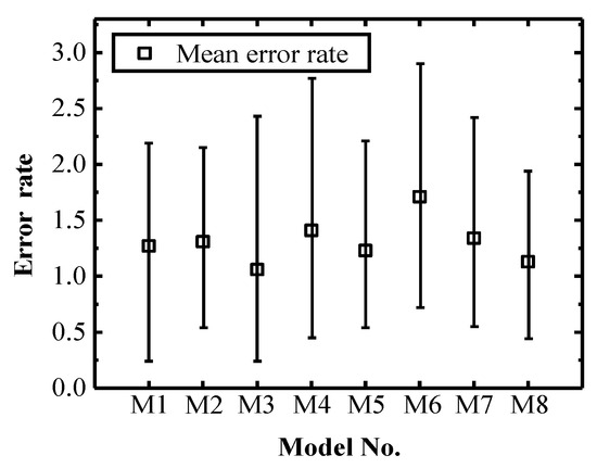
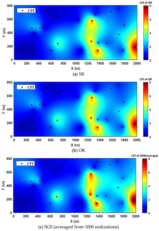
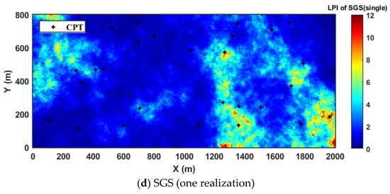
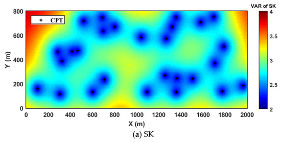
Seismic liquefaction poses a significant threat to infrastructure and human safety, making accurate regional-scale hazard assessment essential for effective disaster mitigation. This study systematically compares simple kriging (SK), ordinary kriging (OK), and sequential Gaussian simulation (SGS) for liquefaction potential mapping using a case study of the Chi-Chi earthquake. Results show that among the eight theoretical semivariogram models, the exponential model was identified as the optimal semivariogram model, showing the best fit and the lowest validation errors. SK and OK yield nearly identical LPI estimates with high accuracy and low computational cost, but oversmooth high-risk zones and underestimate spatial uncertainty. In contrast, SGS captures spatial heterogeneity and extreme values, with variance and coefficient of variation maps revealing higher and more heterogeneous uncertainties, which offers a more comprehensive basis for probabilistic risk assessment. However, these advantages came at a substantially higher computational cost. The choice of method should therefore depend on the engineering objective: kriging for rapid, large-scale trend estimation, and SGS for detailed probabilistic risk evaluation where capturing extreme values and uncertainty is critical.
Full article
(This article belongs to the Special Issue Advances in Earthquake Hazard Assessment and Seismic Risk Mitigation Strategies)
►▼
Show Figures

Figure 1
Open AccessEditorial
Editorial Board Members’ Collection Series: “Trends and Prospects in Geoheritage, Geoparks, and Geotourism”
by
Károly Németh, Marilena Cozzolino and António Vieira
Geosciences 2026, 16(8), 320; https://doi.org/10.3390/geosciences16080320 - 7 Aug 2026
Abstract
In recent years, research in Geoheritage, Geoparks, and Geotourism has significantly increased, underlining their vital roles in advancing scientific knowledge, conserving the environment, and safeguarding human culture. By exploring the intrinsic value of geological and geomorphological sites as records of Earth’s history and
[...] Read more.
In recent years, research in Geoheritage, Geoparks, and Geotourism has significantly increased, underlining their vital roles in advancing scientific knowledge, conserving the environment, and safeguarding human culture. By exploring the intrinsic value of geological and geomorphological sites as records of Earth’s history and important scientific resources, we seek to enhance appreciation for these landscapes. This Special Issue provided a platform for interdisciplinary exploration and dialogue, addressing the complexities of geoheritage research and offering insights into the conservation, management, and promotion of geological features and landforms. It includes studies on the conceptual foundations for establishing and managing geoparks, as well as research on the evolving field of geotourism and its contribution to sustainable development. A total of 10 papers have been accepted, covering a diverse range of topics and emphasizing the current prominence of geoheritage research within the geosciences.
Full article
(This article belongs to the Special Issue Editorial Board Members' Collection Series: "Trends and Prospects in Geoheritage, Geoparks, and Geotourism")
Open AccessArticle
Diagnostics of the Hydrothermal Desynchronization of Snowmelt and Cryogenic Sealing of Soils During the Formation of Extreme Floods in Kazakhstan
by
Zharasbek Baishemirov, Galina Reshetova, Aisha Abobakir and Kadrzhan Shiyapov
Geosciences 2026, 16(8), 319; https://doi.org/10.3390/geosciences16080319 - 6 Aug 2026
Abstract
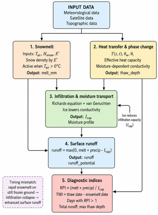
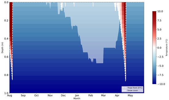
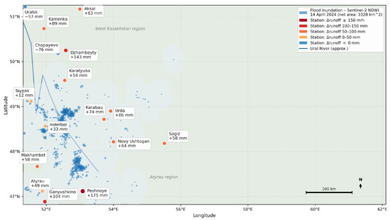
The spring floods that occurred in 2024 in western and northern Kazakhstan caused extensive damage. Our understanding of runoff formation processes under frozen-soil conditions remains limited. In this study, we apply a coupled hydrothermal model as a case study to explicitly simulate vertical
[...] Read more.
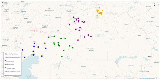
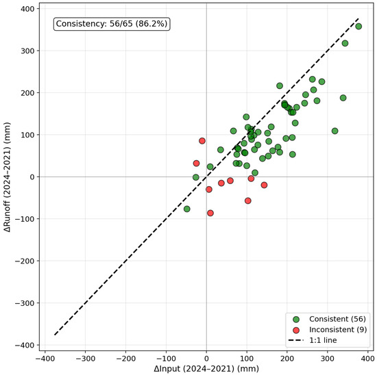
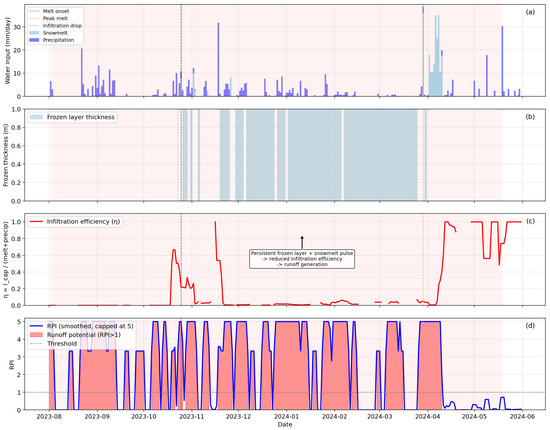
The spring floods that occurred in 2024 in western and northern Kazakhstan caused extensive damage. Our understanding of runoff formation processes under frozen-soil conditions remains limited. In this study, we apply a coupled hydrothermal model as a case study to explicitly simulate vertical heat and water transport, phase transitions, snow dynamics, and reduced infiltration capacity due to cryogenic pore blockage (ice-filled pores). The model is based on regular meteorological data from 65 stations in five regions covering the full hydrological cycle (August–May) of 2021 and 2024. A multilevel diagnostic check showed that soil temperature is reproduced with a median of 0.962 and NSE of 0.888, the frozen/thawed surface condition corresponds to WMO (World Meteorological Organization) standards on approximately 91% of days, and water balance agreement reaches 86.2% (56 out of 65 stations). The model reflects the regional variability of the 2024 flood. In the northern regions (Kostanay, North Kazakhstan), snowfall was above average, and modeled runoff increased compared to 2021 (for example, at the Sergeevka station, it increased by a factor of four). In the western regions, the trends were mixed: the strongest relative increase in runoff was recorded in the Atyrau region (+119%), whilst in the West Kazakhstan region, the increase was more modest (+19%), and in the Aktobe region, runoff increased by 60%. The key mechanism—the time lag between rapid snowmelt and delayed soil thaw—is clearly evident: peaks in snowmelt occur when the soil remains frozen, infiltration capacity decreases, and the runoff potential index (RPI) exceeds 1 for extended periods. Although the model does not simulate the river channel, its ability to diagnose runoff generation conditions at the slope scale offers a diagnostic framework for identifying runoff-conducive conditions in regions with limited data, rather than a physically validated tool for flood-prone area identification. The results show that the 2024 flood period was characterized by abnormally high water inflow and hydrothermal conditions consistent with a temporal mismatch between water supply and the recovery of soil infiltration capacity. Because the RPI is a diagnostic indicator constructed from water input and infiltration capacity, these results should be interpreted as evidence of conditions conducive to runoff generation rather than as an independent causal verification of the flood mechanism.
Full article
(This article belongs to the Special Issue Integrating Geomorphological and Hydrological Insights for Flood Risk Assessment)
►▼
Show Figures

Figure 1

Open AccessArticle
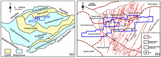
Genesis and Prediction Method of Local Abnormal Pressure in Carbonate Strata Controlled by Strike–Slip Faults: A Case Study of the Fudong Block, Fuman Oilfield, Tarim Basin
by
Zhipeng Huan, Yingchang Cao, Wei Ju, Ziwei Qian, Ke Xu, Penglin Zheng, Zhou Xie, Mingjin Cai and Ruidong Liu
Geosciences 2026, 16(8), 318; https://doi.org/10.3390/geosciences16080318 - 6 Aug 2026
Abstract
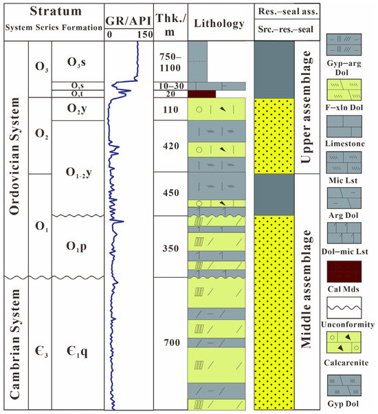
Ultra-deep Ordovician carbonates in the Tarim Basin are a major target for oil and gas exploration in China. Localized overpressure, however, creates substantial well-control risks and impairs drilling safety and exploration performance. This study investigates the Fudong Block of the Fuman Oilfield using
[...] Read more.
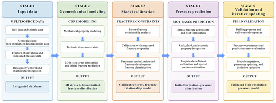
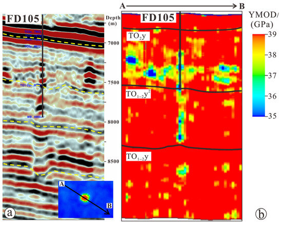
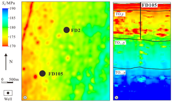
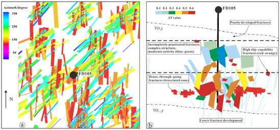
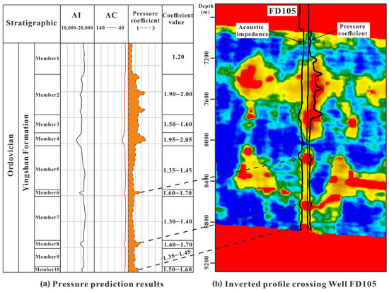
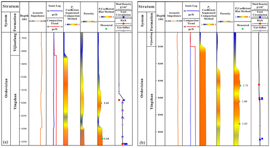
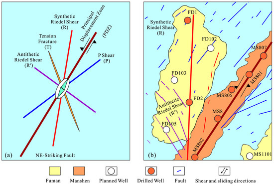
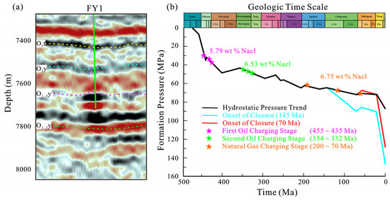
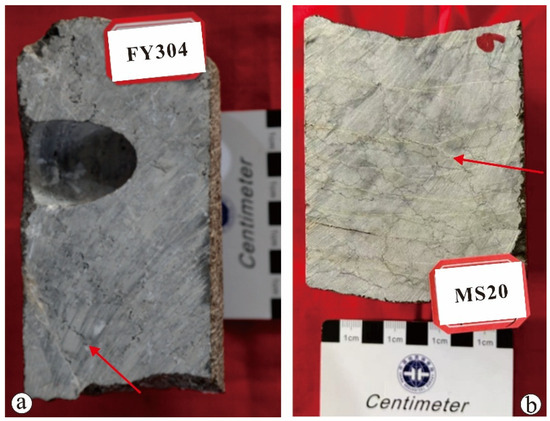
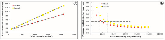
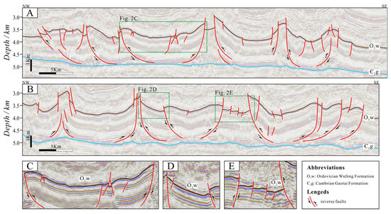
Ultra-deep Ordovician carbonates in the Tarim Basin are a major target for oil and gas exploration in China. Localized overpressure, however, creates substantial well-control risks and impairs drilling safety and exploration performance. This study investigates the Fudong Block of the Fuman Oilfield using drilling, seismic, and well-test data. We develop a high-resolution, layer-specific formation-pressure prediction workflow that integrates well and seismic data through a stress–fracture-pressure framework. The workflow combines geomechanical modeling, prediction of the in situ stress field and fracture distribution, stress-fracture matching, Biot-theory-based pressure prediction, and iterative calibration against drilling observations. The results show that: (1) overpressure is concentrated near secondary faults, branch faults, and NW-trending faults. It is jointly controlled by tectonic compression, pressure retention within fracture–vug bodies, and fluid charging. Multiple vertically separated pressure systems are common, and their marked heterogeneity is closely related to secondary-fault development and fracture–vug connectivity; (2) drilling disturbance can generate apparent overpressure and lead to erroneous pressure interpretation. Overpressured wells commonly exhibit a kick followed by lost circulation or simultaneous kick and loss. Drilling-fluid invasion into confined fracture–vug bodies causes pressure buildup; and (3) formation pressure is a key parameter in integrated geological and engineering sweet-spot evaluation and is closely linked to wellbore stability. Field applications confirm the accuracy of the proposed workflow. The method strengthens integrated geology-engineering evaluation and provides a practical basis for the safe and efficient development of ultra-deep carbonate reservoirs.
Full article
(This article belongs to the Special Issue Fault Characteristics, Fault Zone Architecture and Fluid Behavior)
►▼
Show Figures

Figure 1
Open AccessArticle
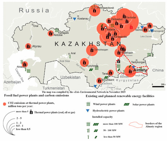
Geological Conditions for the Formation of Underground Reservoirs for CO2 Sequestration in Southern Kazakhstan
by
Sara Istekova, Alexandr Logvinenko, Daniyar Kairov, Yernar Narimanov, Nurbek Shamiyev, Raushan Temirkhanova and Nurastana Slambek
Geosciences 2026, 16(8), 317; https://doi.org/10.3390/geosciences16080317 - 6 Aug 2026
Abstract
This paper presents findings from a comprehensive assessment aimed at identifying deep geological storage formations suitable for the secure isolation of chemically active gases, including anthropogenic CO2. Although Kazakhstan currently lacks operational industrial-scale CO2 storage sites, high annual emissions exceeding
[...] Read more.
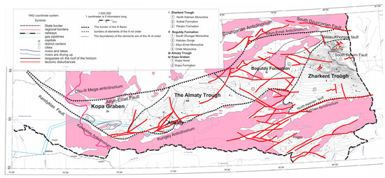
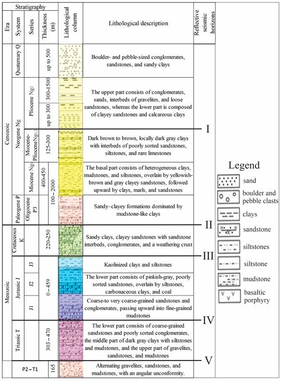
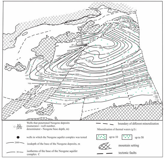
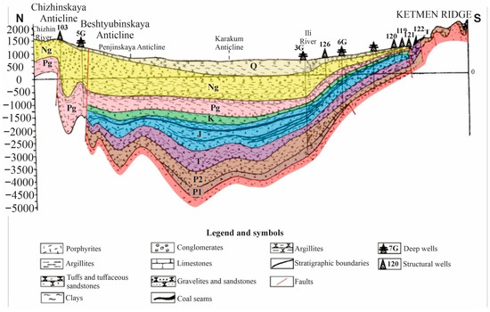
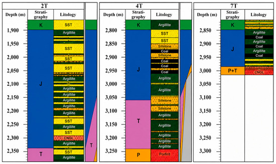
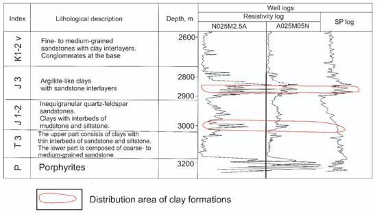
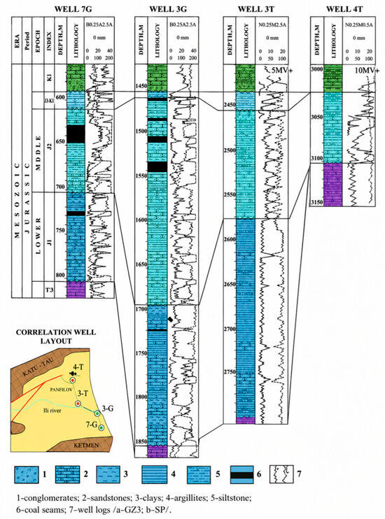
This paper presents findings from a comprehensive assessment aimed at identifying deep geological storage formations suitable for the secure isolation of chemically active gases, including anthropogenic CO2. Although Kazakhstan currently lacks operational industrial-scale CO2 storage sites, high annual emissions exceeding 2 million tonnes are concentrated in its southern region, specifically Almaty city and the surrounding Almaty Region. Despite this pressing need, the precise location, availability, and capacity of potential storage sites in this area remain poorly understood. By synthesizing legacy geological, geophysical, and hydrogeological datasets compiled within the eastern Ili Depression, this study evaluates regional deep saline aquifers for potential CO2 geological storage under favorable techno-economic conditions. It must be clearly emphasized that this study focuses exclusively on deep groundwater aquifers (saline aquifers). Leveraging historical seismic, drilling, and well-logging data originally acquired for petroleum and water resource exploration, we constrain the stratigraphic architecture and structural framework of prospective storage units. The lithostratigraphic framework of the sedimentary cover in the Ili Basin is established, identifying key reservoir intervals and effective sealing formations. The results indicate that the eastern Ili Depression offers highly favorable conditions for geologic storage, with Permian, Triassic, and Jurassic sedimentary successions reaching thicknesses of up to 1200 m. Reservoir intervals are identified across major stratigraphic units, with potential storage formations accounting for up to 60% of the stratigraphic volume. Specifically, the Miocene–Paleogene and Jurassic intervals host sandstone reservoirs exceeding 10 m in thickness, with porosities reaching up to 30%. Upper Jurassic clayey successions function as effective intraformational seals for Middle Jurassic reservoirs, while Upper Cretaceous clay sequences provide regional caprock integrity for the overlying Neogene–Paleogene sandy intervals. These geological settings satisfy rigorous containment criteria required for secure gas sequestration. These insights into the deep architecture of the Ili Depression elucidate key geological controls governing prospective storage sites, paving the way for future carbon capture and storage (CCS) initiatives in one of Kazakhstan’s most vital economic regions.
Full article
(This article belongs to the Section Geophysics)
►▼
Show Figures

Figure 1

Open AccessArticle
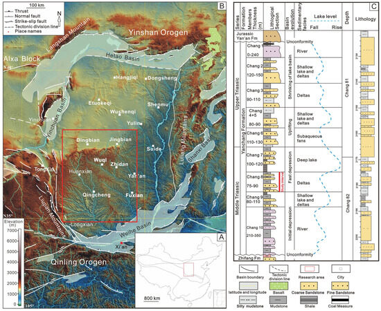
Divergent Chlorite and Kaolinite Authigenesis and Reservoir Quality Controls: Chang-8 Tight Sandstones, Ordos Basin
by
Wei Yu, Jiao Wang, Li Gong and Jie Chen
Geosciences 2026, 16(8), 316; https://doi.org/10.3390/geosciences16080316 - 6 Aug 2026
Abstract
The genesis of authigenic clay minerals in tight sandstones fundamentally controls reservoir quality and micro-pore evolution. This study investigates the differential formation mechanisms of authigenic chlorite and kaolinite and their modulating effects on pore systems in the Chang-8 Member tight sandstones, Ordos Basin.
[...] Read more.
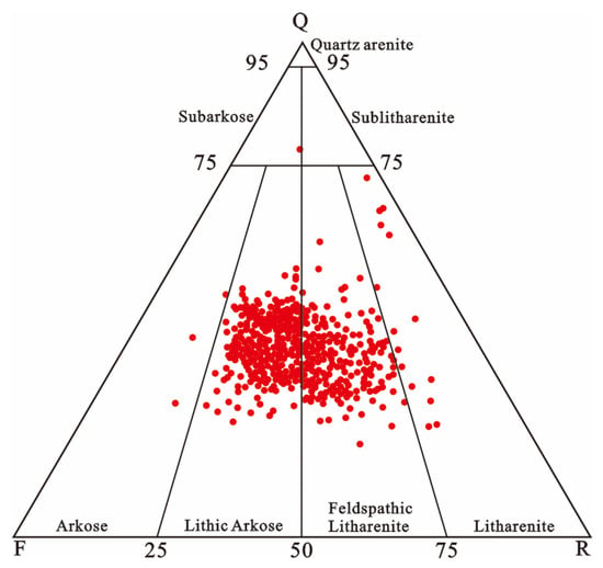
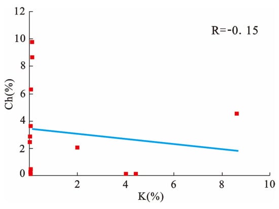
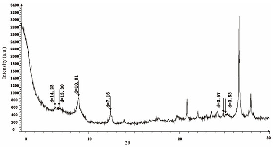
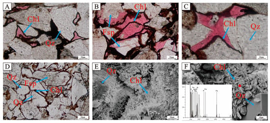
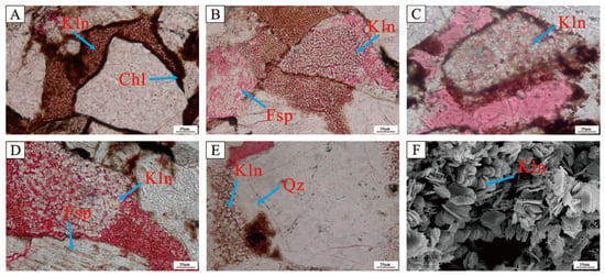
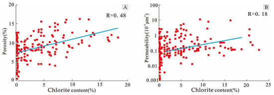
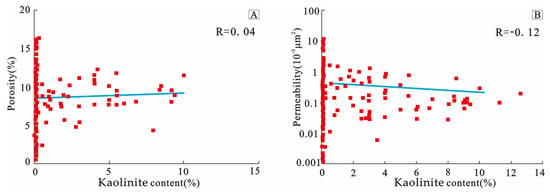
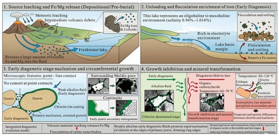
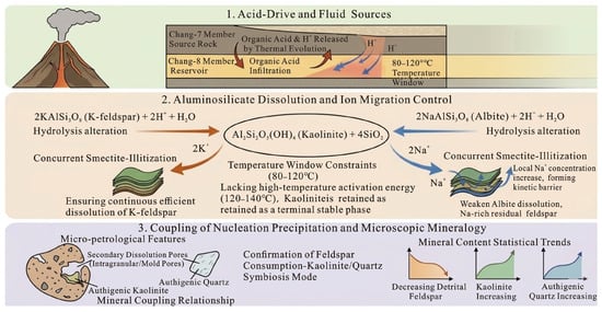
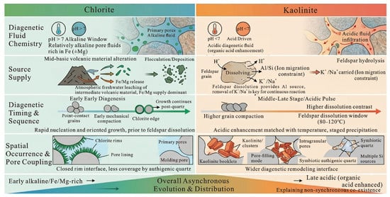
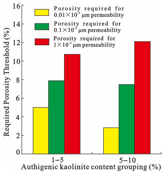
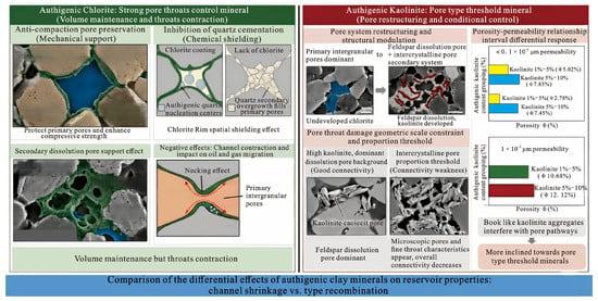
The genesis of authigenic clay minerals in tight sandstones fundamentally controls reservoir quality and micro-pore evolution. This study investigates the differential formation mechanisms of authigenic chlorite and kaolinite and their modulating effects on pore systems in the Chang-8 Member tight sandstones, Ordos Basin. Thin-section petrography, X-ray diffraction, scanning electron microscopy, and high-pressure mercury injection were utilized to quantify mineralogical and petrophysical characteristics. Results show chlorite (averaging 4.8%) and kaolinite (averaging 1.6%) are the dominant authigenic clay minerals with distinct spatiotemporal distributions. Chlorite nucleated as pore linings during early diagenesis under alkaline, oligohaline to mesohaline conditions driven by volcanic material hydration. Conversely, kaolinite precipitated as pore-filling during mid-to-late diagenesis (80–120 °C), driven by organic acid pulses from underlying source rocks causing feldspar dissolution. We conclude that early chlorite linings constructively preserve primary porosity by mechanically resisting compaction and chemically inhibiting quartz cementation, despite narrowing pore throats. Meanwhile, kaolinite acts as a pore-type modulator, restructuring macro-pores into micro-intercrystalline pores, which significantly impairs permeability only when its proportion crosses a critical threshold. The diagenetic fluid transition from alkaline to acidic ultimately dictates this mineralogical succession and subsequent reservoir heterogeneity.
Full article
(This article belongs to the Special Issue Sedimentary Basins and Energy Resources)
►▼
Show Figures

Figure 1

Open AccessArticle
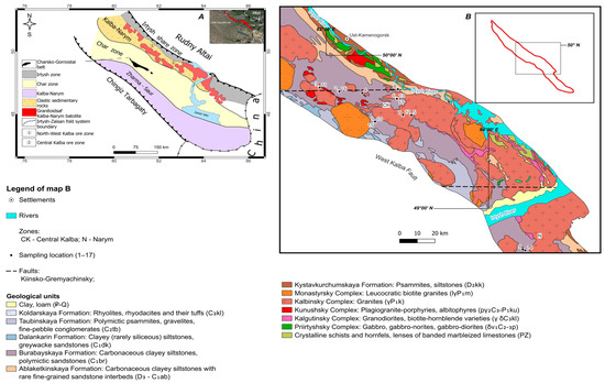
Progressive Melt Fractionation as the Primary Control on the Formation of Rare-Metal Pegmatites: Evidence for Continuous Granite–Pegmatite Evolution in the Central Kalba Ore District, Eastern Kazakhstan
by
Marina A. Mizernaya, Saltanat S. Aitbayeva, Anastassiya P. Miroshnikova, Reimar Seltmann, Alla Dolgopolova, Oxana N. Kuzmina, Christophe Pascal, Bakytzhan B. Amralinova, Zinaida I. Chernenko and Zhanar Z. Kapzhaparova
Geosciences 2026, 16(8), 315; https://doi.org/10.3390/geosciences16080315 - 5 Aug 2026
Abstract
Rare-metal pegmatites of the Kalba–Narym belt (Eastern Kazakhstan) represent an important source of Li, Cs, Ta, Nb, Be, and associated critical metals. Despite extensive geological investigations, the relationships between granites, pegmatites, and late-stage alteration products within the Central Kalba ore district remain insufficiently
[...] Read more.
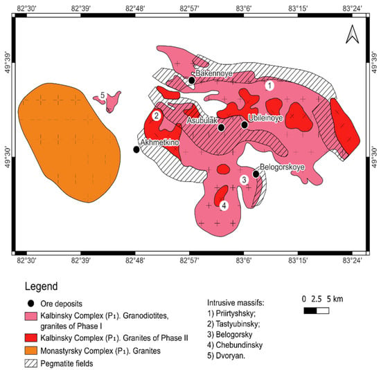
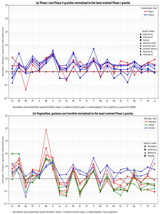
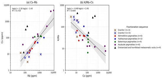
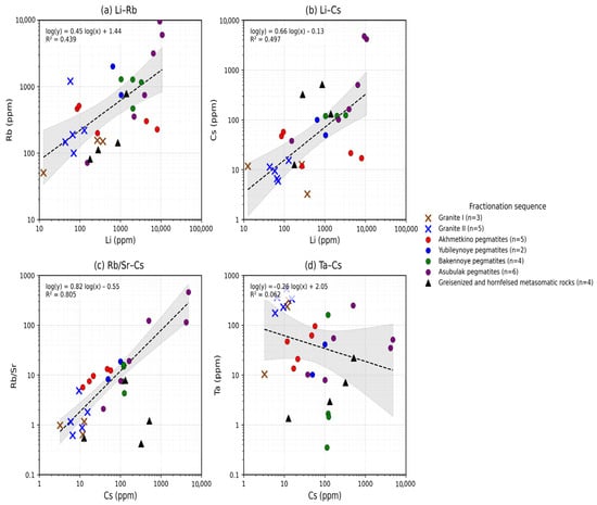
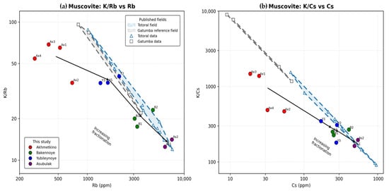
Rare-metal pegmatites of the Kalba–Narym belt (Eastern Kazakhstan) represent an important source of Li, Cs, Ta, Nb, Be, and associated critical metals. Despite extensive geological investigations, the relationships between granites, pegmatites, and late-stage alteration products within the Central Kalba ore district remain insufficiently constrained. This study integrates whole-rock geochemistry and muscovite trace-element data to evaluate regional fractionation trends and rare-metal enrichment within the granite–pegmatite system. The dataset comprises 29 whole-rock samples, including Phase I and Phase II granites, pegmatites, greisens, and hornfels, together with 11 muscovite separates from the Akhmetkino, Yubileynoye, Bakennoye, and Asubulak ore fields. Geochemical evolution was assessed using granite-normalized multi-element patterns and the Cs–Rb, K/Rb–Cs, Li–Rb, Li–Cs, Rb/Sr–Cs, and Ta–Cs relationships. Muscovite compositions were additionally compared with published datasets from the Totoral (Argentina) and Gatumba (Rwanda) pegmatite districts. The results reveal systematic enrichment in Li, Rb, Cs, Nb, and Ta accompanied by depletion in Sr and Ba from granites to the most evolved pegmatites. The strongest geochemical relationship is recorded by the Rb/Sr–Cs system (R2 = 0.805), whereas Ta and Cs show only weak correlation (R2 = 0.062). Muscovite compositions display decreasing K/Rb and K/Cs ratios and increasing Rb and Cs concentrations from Akhmetkino through Yubileynoye and Bakennoye to Asubulak, defining a regional fractionation sequence consistent with whole-rock geochemistry. The most evolved muscovites overlap compositional fields characteristic of highly fractionated LCT pegmatites. The geochemical patterns identified in both whole-rock and muscovite datasets indicate progressive melt evolution across the Central Kalba district. Late-stage alteration and volatile-rich mineral assemblages record additional fluid-related processes, although their quantitative contribution to rare-metal redistribution remains uncertain. The results identify Cs, Rb/Sr, K/Rb, and K/Cs as useful indicators of relative pegmatite evolution and provide new constraints on the development of rare-metal granite–pegmatite systems in Eastern Kazakhstan.
Full article
(This article belongs to the Section Geochemistry)
►▼
Show Figures

Figure 1

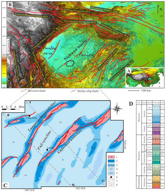
Open AccessArticle
Topological Analysis of Fault Connectivity: Implications for Shale Gas Preservation in the Luzhou Area, Sichuan Basin
by
Yicheng Mou, Wei Guo, Zhengshuo Miao, Yonghe Zhai, Jingru Zhao, Yongbo Wei and Yangwen Pei
Geosciences 2026, 16(8), 314; https://doi.org/10.3390/geosciences16080314 - 5 Aug 2026
Abstract
Fault networks play a critical role in controlling hydrocarbon flow within petroliferous basins; however, quantitative characterization of fault network systems and their specific influence on hydrocarbon preservation in tight sedimentary rocks remain insufficient. This study investigates the Luzhou shale gas production area in
[...] Read more.
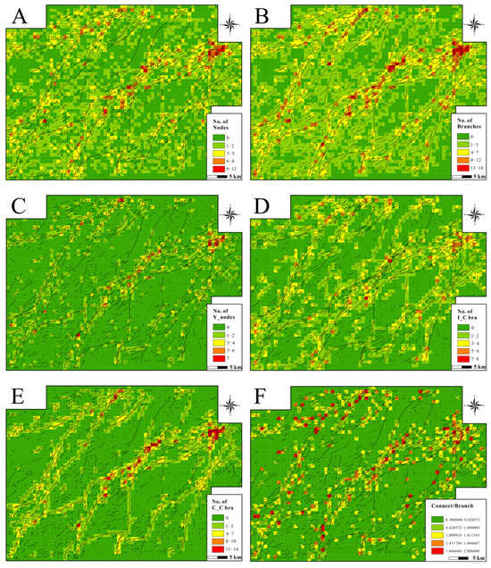
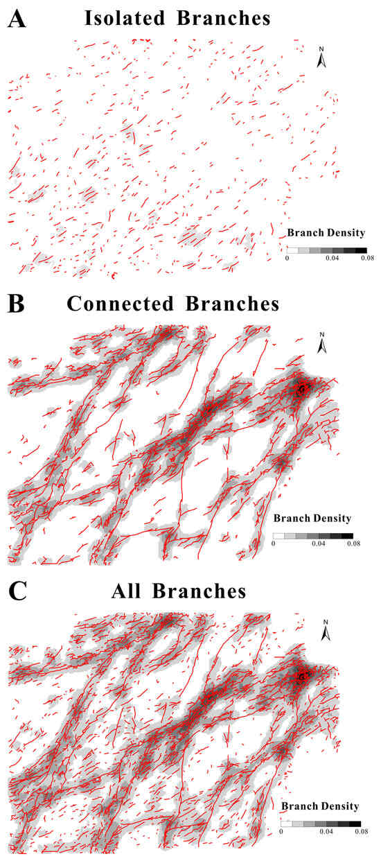
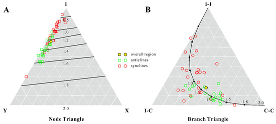
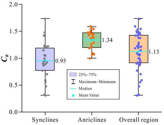
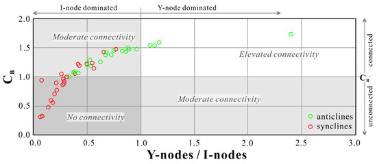
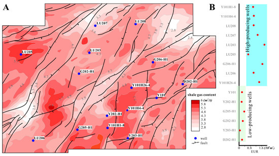
Fault networks play a critical role in controlling hydrocarbon flow within petroliferous basins; however, quantitative characterization of fault network systems and their specific influence on hydrocarbon preservation in tight sedimentary rocks remain insufficient. This study investigates the Luzhou shale gas production area in the Sichuan Basin, which has been modified by multi-stage tectonic superimposition, employing topological theory to quantitatively evaluate the structural architecture and connectivity of reservoir fault networks, and to elucidate their control on shale gas preservation. Our results reveal significant heterogeneity in the development and distribution of fault network systems within the study area. Faults are more developed in anticlinal belts, which experienced concentrated compressional stress, and the median connectivity of fault networks in shale reservoirs within these belts (CB = 1.34) is substantially higher than that in synclinal belts (CB = 0.95). The higher geometric connectivity observed in anticlinal belts may increase the continuity of potential migration pathways, whereas the generally lower connectivity of many synclinal areas may be more favorable for shale gas preservation. Estimated ultimate recovery data from shale gas wells in different structural zones show a spatial association broadly consistent with the fault-network connectivity pattern, although well performance may also be influenced by other geological and engineering factors. This study provides a quantitative analytical framework for characterizing fault-network connectivity in complex structural zones and offers insights into the potential role of fault-network connectivity in shale gas preservation and exploration.
Full article
(This article belongs to the Section Structural Geology and Tectonics)
►▼
Show Figures

Figure 1
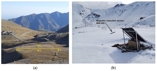
Open AccessArticle
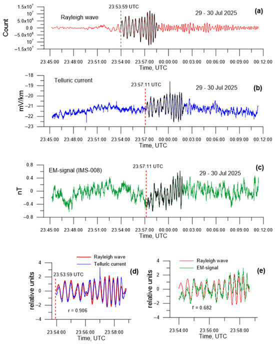
Coseismic Telluric Current Response to the Propagation of Rayleigh Wave from the 2025 Kamchatka Earthquakes (M ≤ 8.8) at Distances of About 6000 km in the Northern Tien Shan Region
by
Nazyf Salikhov, Galina Pak, Serik Nurakynov, Dauren Kurmanov, Alexander Shepetov, Vladimir Ryabov and Valery Zhukov
Geosciences 2026, 16(8), 313; https://doi.org/10.3390/geosciences16080313 - 5 Aug 2026
Abstract
A study was performed on the electromagnetic response of the geological medium during the propagation of Rayleigh waves from the 2025 Kamchatka earthquakes (M8.8–7.4) at an epicentral distance of approximately 6000 km. The identities of the coseismic telluric current variations and
[...] Read more.
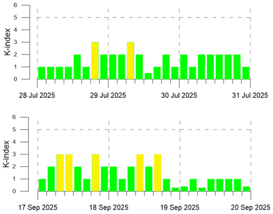
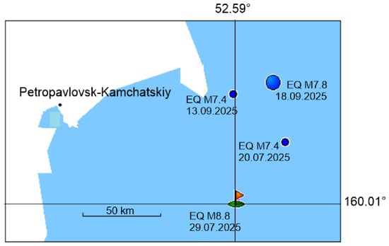
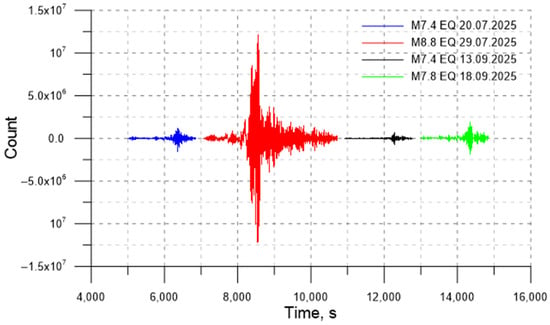
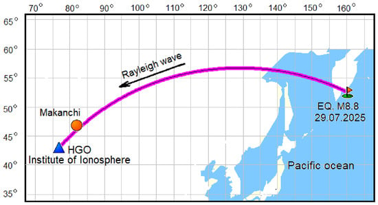
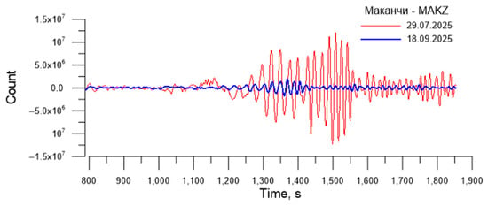
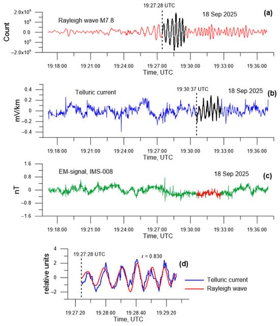
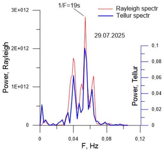
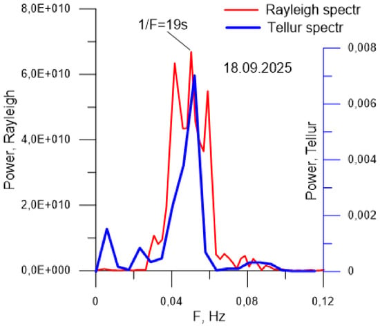
A study was performed on the electromagnetic response of the geological medium during the propagation of Rayleigh waves from the 2025 Kamchatka earthquakes (M8.8–7.4) at an epicentral distance of approximately 6000 km. The identities of the coseismic telluric current variations and the propagating Rayleigh wave have been revealed, with their power spectra exhibiting a pronounced quasi-line structure with dominant peaks at 0.04 Hz, 0.054 Hz, and 0.064 Hz. The high correlation of the telluric current response with the Rayleigh wave (r = 0.906, M8.8 and r = 0.83, M7.8) allowed the seismoelectric effect of the second kind to be considered the dominant mechanism for disturbance generation. Electromagnetic signals recorded by the IMS-008 induction sensor showed a lower correlation (r = 0.682), which may be attributed to the shaking of the induction sensor during the passage of the Rayleigh wave, though this does not preclude the presence of a true coseismic signal. Coseismic effects were recorded during the M7.8 and M8.8 earthquakes, but were absent during the M7.4 events. For the first time for the Northern Tien Shan region (at teleseismic distances of approximately 6000 km), key regularities in the generation of the seismoelectric effect during Rayleigh wave propagation have been identified. It is shown that the telluric current response is characterized by a threshold sensitivity to the event magnitude, with the magnitude of induced current variations strictly consistent with the intensity of the seismic wave’s dynamic impact. Utilizing telluric currents as a physical reference for the precise determination of Rayleigh wave arrival times allowed for the refinement of the Rayleigh wave group velocity (3.078–3.093 km/s), reducing calculation uncertainty to 0.5%.
Full article
(This article belongs to the Special Issue Applied Geophysics for Geohazards Investigations)
►▼
Show Figures

Figure 1
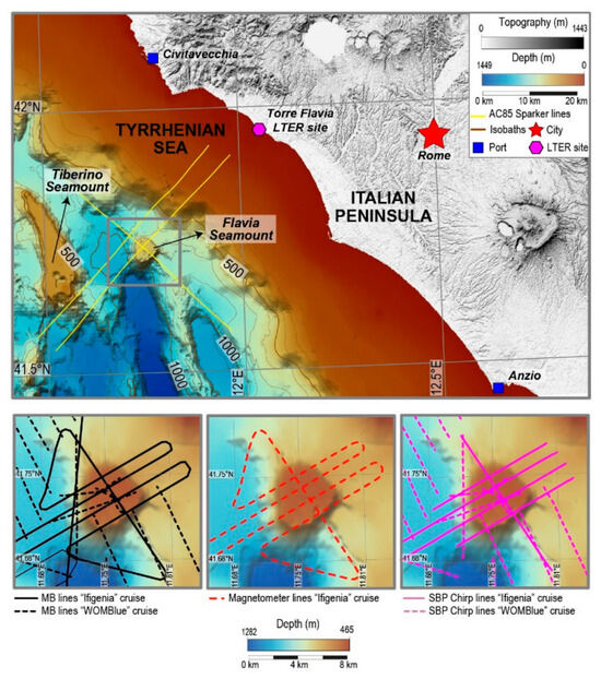
Open AccessArticle
An Integrated Geophysical Investigation of the Flavia Seamount in the Northern Tyrrhenian Back-Arc Basin (Mediterranean Sea)
by
Camilla Palmiotto, Francesca Ape, Malek Belgacem, Lucia Bongiorni, Luca Cocchi, Alessia Conti, Marco Cuffaro, Giacomo Dalla Valle, Amelia De Lazzari, Eleonora Ficini, Andrea Fiorentino, Andrea Gallerani, Fabiano Gamberi, Donatella Domenica Insinga, Maria Filomena Loreto, Alessandra Mercorella, Filippo Muccini, Simone Muzzioli, Yago Nestola, Simone Orefice, Alessandra Pensa, Angelica Pesce, Lorenzo Petracchini, Francesco Riminucci, Stefania Romano, Marzia Rovere, Fabio Savelli, Anna Tozzi, Marina Vingiani and Valentina Ferranteadd
Show full author list
remove
Hide full author list
Geosciences 2026, 16(8), 312; https://doi.org/10.3390/geosciences16080312 - 4 Aug 2026
Abstract
Despite its geodynamic significance, the northern Tyrrhenian Back-Arc Basin, characterized by a complex tectono-magmatic evolution, remains poorly investigated. We present the first geophysical characterization of the Flavia Seamount, a previously uninvestigated edifice in the northern Tyrrhenian Sea, integrating new multibeam, seismic, and magnetic
[...] Read more.
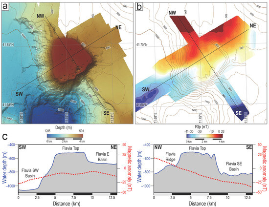
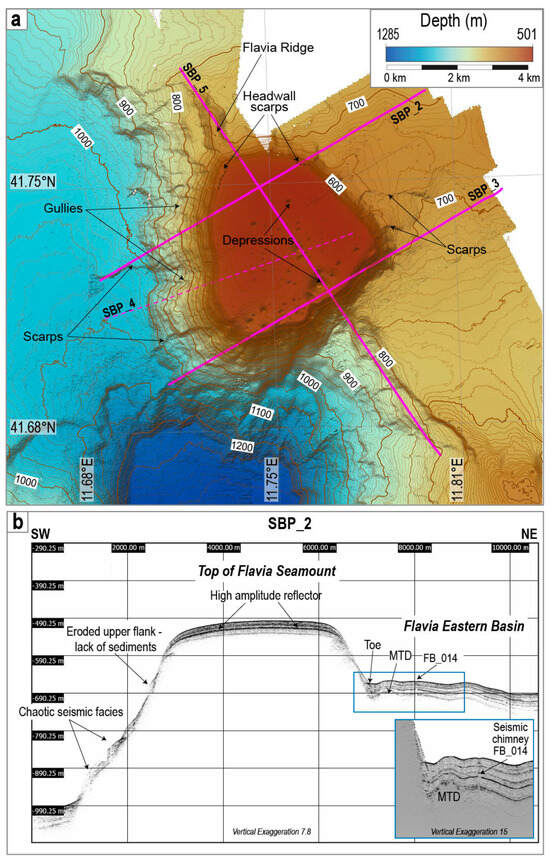
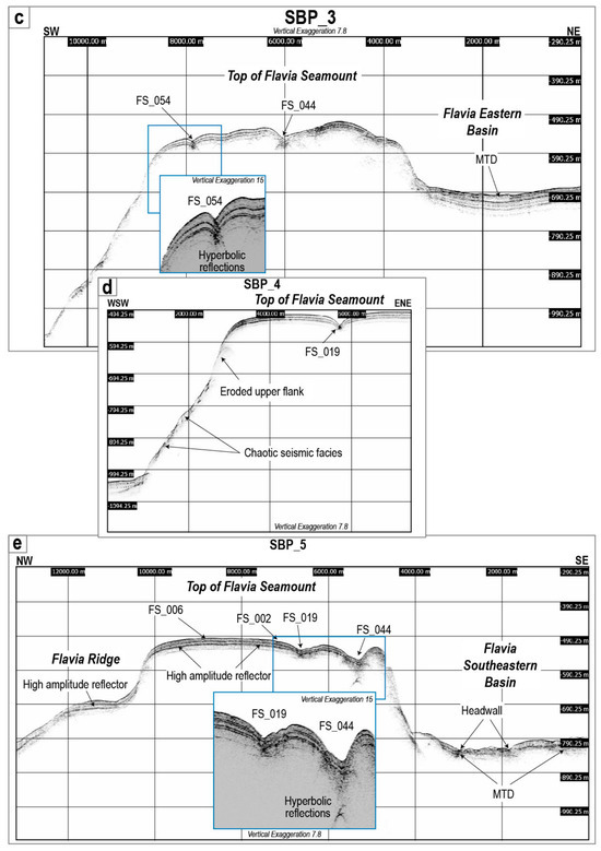
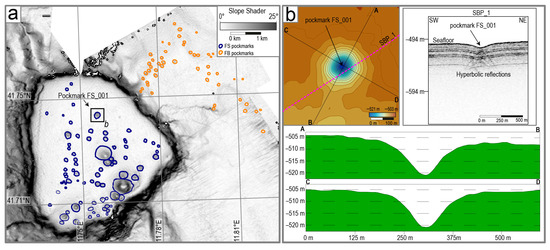
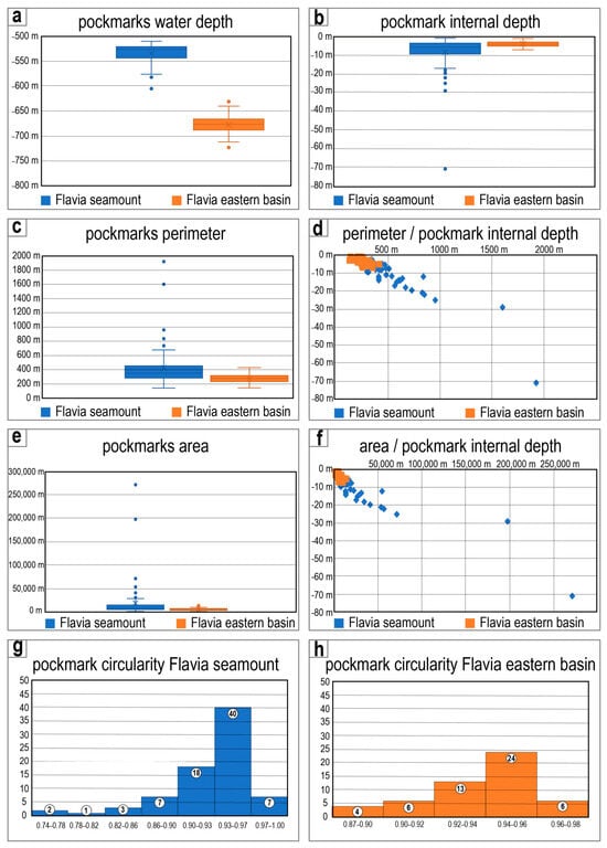
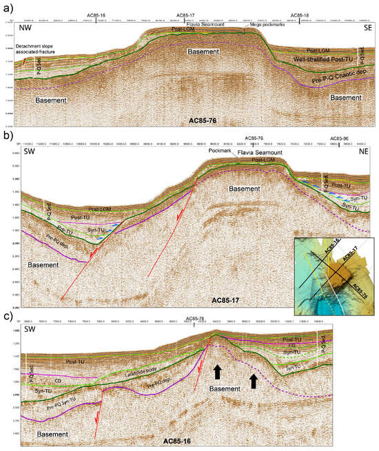
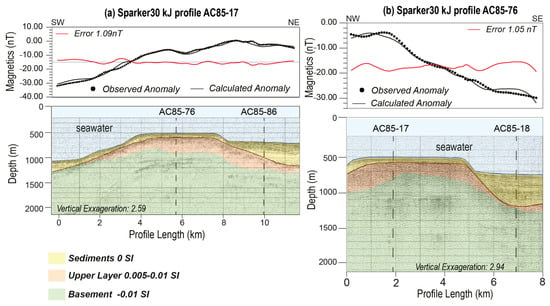
Despite its geodynamic significance, the northern Tyrrhenian Back-Arc Basin, characterized by a complex tectono-magmatic evolution, remains poorly investigated. We present the first geophysical characterization of the Flavia Seamount, a previously uninvestigated edifice in the northern Tyrrhenian Sea, integrating new multibeam, seismic, and magnetic data. The new high-resolution bathymetric data reveal a flat, nearly circular summit and strongly asymmetric flanks. Reduced-to-the-pole magnetic anomalies exhibit a north–south polarity pattern, with positive values in the northern sector and negative values in the southern sector. Seismic data, integrated with Sparker profiles collected in 1985, reveal a flat-topped acoustic basement overlain by a ~100 m thick stratified sequence and affected by inactive east-dipping extensional faults, indicating tectonic control on the evolution of the seamount. Widespread landslide scarps and associated mass-transport deposits document recurrent gravitational instability along the flanks and within surrounding basins. Pockmark morphometry suggests distinct formation processes, with summit pockmarks controlled by fluid seepage and gravitational processes, and basin pockmarks mainly related to fluid escape from mass-transport deposits. Magnetic forward modelling constrained by seismic data provides new insights into the distribution of magnetic susceptibility bodies and the crustal architecture beneath the seamount. Results suggest that the present-day morphology of the Flavia Seamount reflects the combined effects of tectonic, sedimentary, and gravitational processes.
Full article
(This article belongs to the Special Issue Advancements in Marine Geology: Underwater Exploration and Geophysical Insights)
►▼
Show Figures

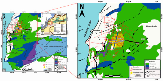
Figure 1
Open AccessArticle
Structural and Stratigraphic Control on Reservoir Quality in a Salt-Influenced Jurassic Carbonate Platform: Callovian–Oxfordian of the Toukimt Field, Essaouira Basin, Morocco
by
Bouchra Cherradi, Aude Duval-Arnould, Abdallah Ait Salem, Mohammed Farssi, Asmae Benarchid and Nadia Mhammdi
Geosciences 2026, 16(8), 311; https://doi.org/10.3390/geosciences16080311 - 4 Aug 2026
Abstract
The Middle-Upper Jurassic carbonate succession of the onshore Essaouira Basin forms a hydrocarbon play comparable to Atlantic passive-margin systems. In the Toukimt field, gas and condensate have been produced from fractured Argovian dolomites, but reservoir prediction remains difficult because facies variability, diagenetic overprint,
[...] Read more.
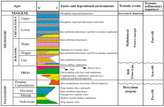
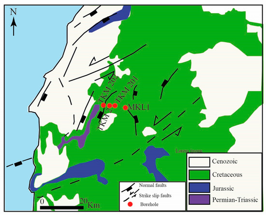
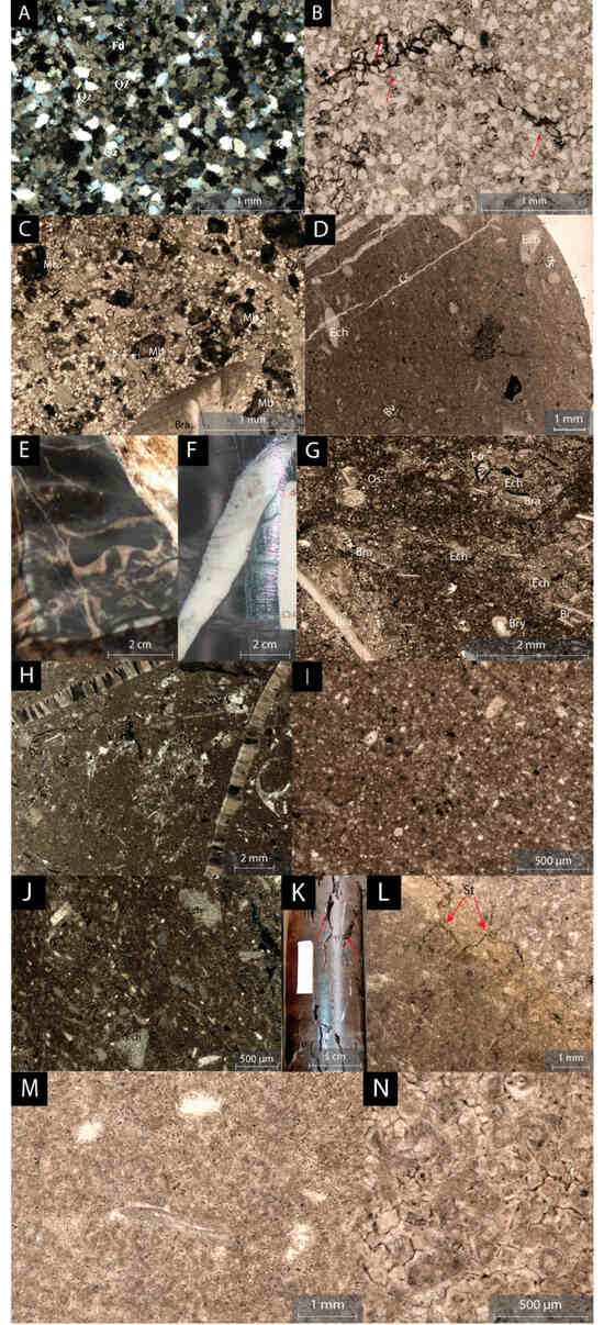
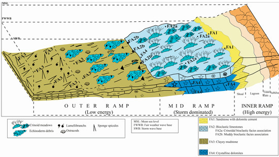
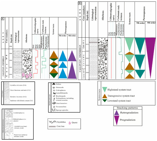
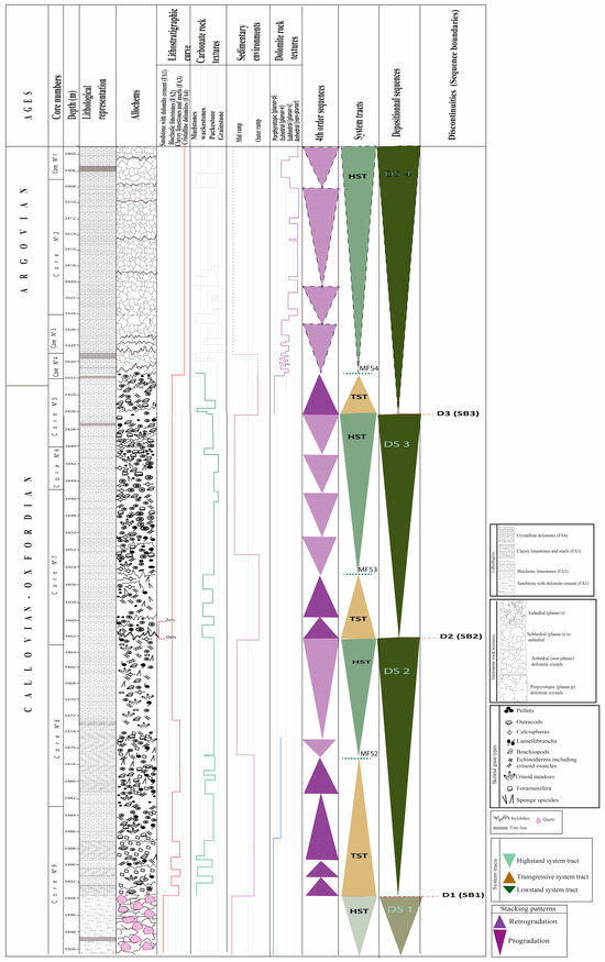
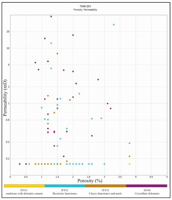
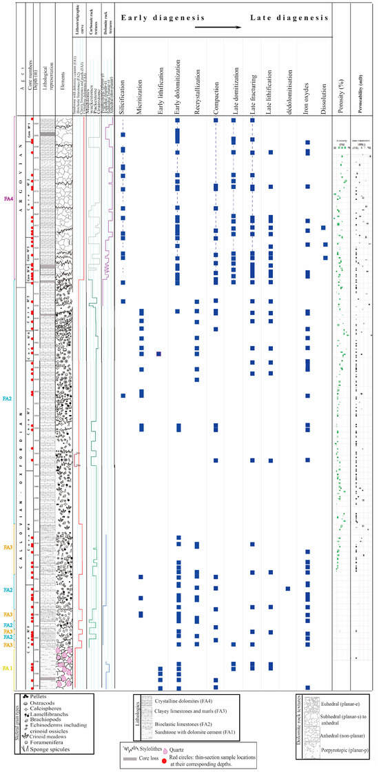
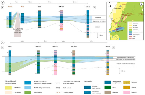
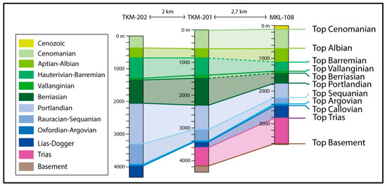
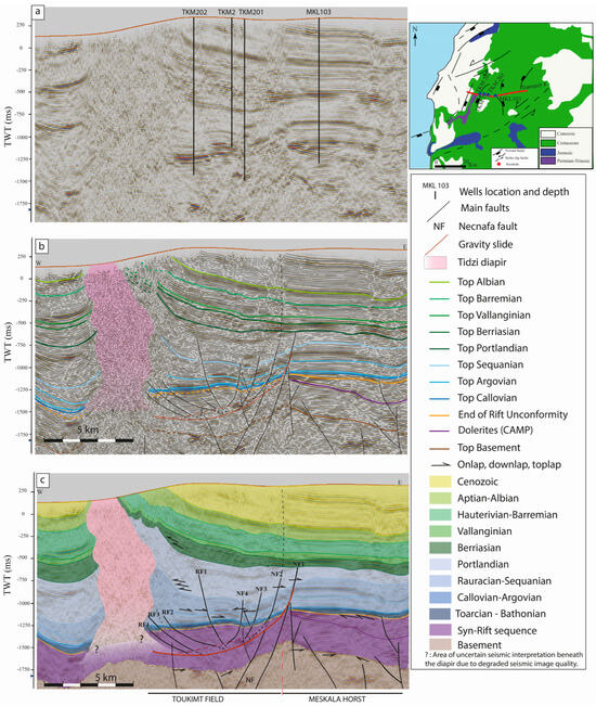
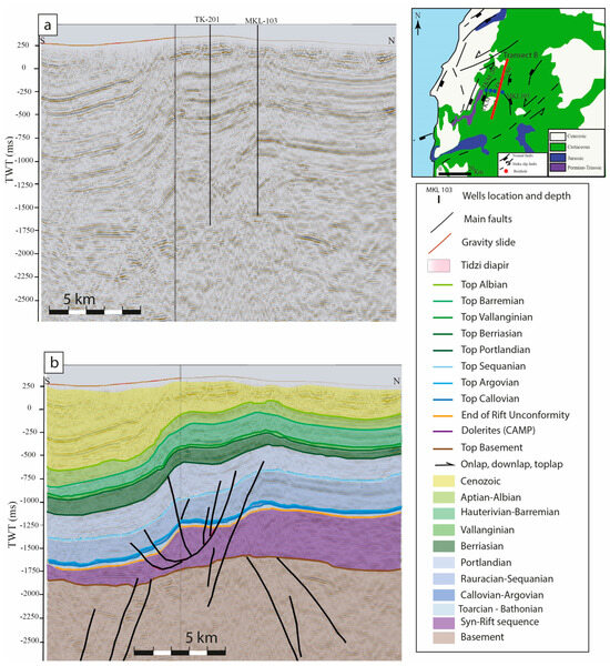
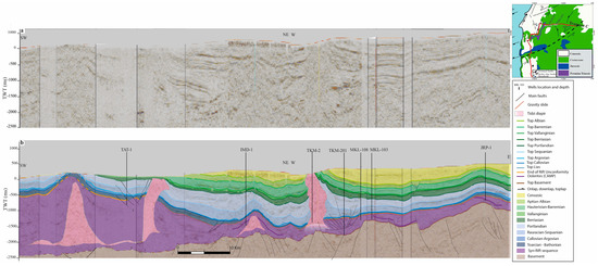
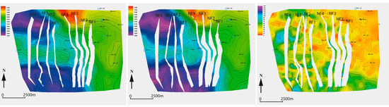
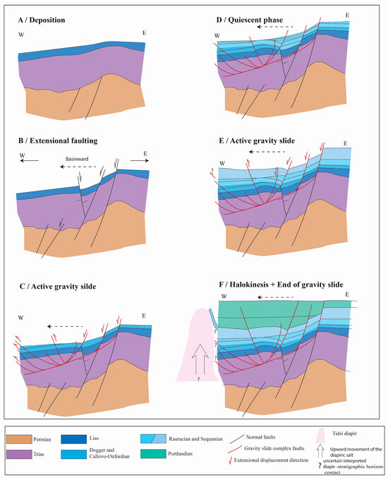
The Middle-Upper Jurassic carbonate succession of the onshore Essaouira Basin forms a hydrocarbon play comparable to Atlantic passive-margin systems. In the Toukimt field, gas and condensate have been produced from fractured Argovian dolomites, but reservoir prediction remains difficult because facies variability, diagenetic overprint, and fracture development generate heterogeneities. This study characterizes the sedimentological framework of the Callovian–Argovian (Middle Oxfordian) succession, establishes a sequence-stratigraphic framework, and evaluates the role of halokinesis in controlling accommodation and sediment distribution. The analysis integrates core-based sedimentology, well correlations, high-resolution sequence stratigraphy, and 2D-3D seismic interpretation. Four facies associations have been defined in the ramp system ranging from grain-rich biodetrital shoals to micritic outer-ramp facies. The succession is organized into four depositional sequences (DS1–DS4) showing a shallowing-upward trend with alternating retrogradational flooding and progradational colonization parasequences. Reservoir-prone intervals occur within highstand shoal facies, where depositional texture provides a favorable framework, while fracturing and dissolution enhance petrophysical properties. Seismic data reveal a gravity-driven rollover structure linked to west-dipping listric faulting and salt withdrawal within a long-lived halokinetic system active since the Early Jurassic. Basin-ward growth of the Tidsi diapir generated asymmetric subsidence, indicating that inherited structures, halokinesis, gravity sliding, and diagenesis jointly controlled accommodation, reservoir geometry and quality.
Full article
(This article belongs to the Topic Reservoir Genesis and Quality Evolution in Hydrocarbon Systems)
►▼
Show Figures

Figure 1

Open AccessArticle
Cross-Country Transferability of Deep Learning Models for Artisanal and Small-Scale Mining Mapping in Ghana and Côte d’Ivoire
by
Bismark Ade, Omid Ghorbanzadeh and Thomas Blaschke
Geosciences 2026, 16(8), 310; https://doi.org/10.3390/geosciences16080310 - 2 Aug 2026
Abstract
Artisanal and small-scale mining (ASM) is expanding across West Africa, driving deforestation, water contamination, and land degradation that require scalable monitoring approaches. Deep learning (DL) models applied to Sentinel imagery have shown acceptable performance for ASM mapping within individual countries, but their ability
[...] Read more.
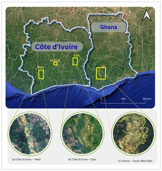
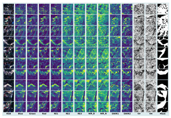
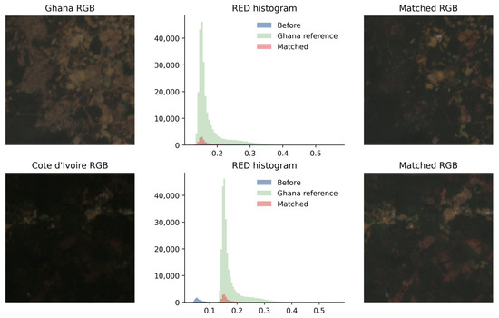
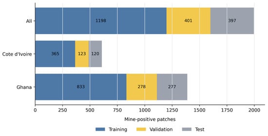
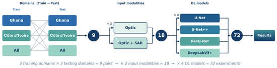
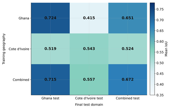
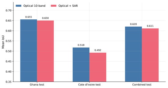
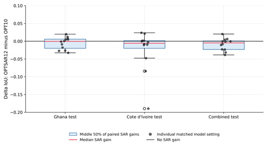
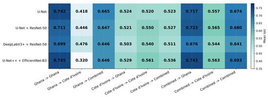
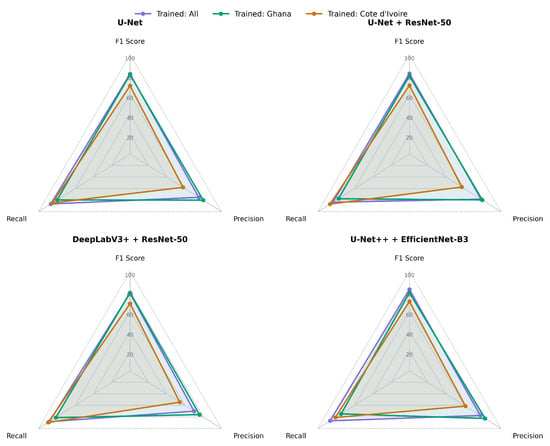
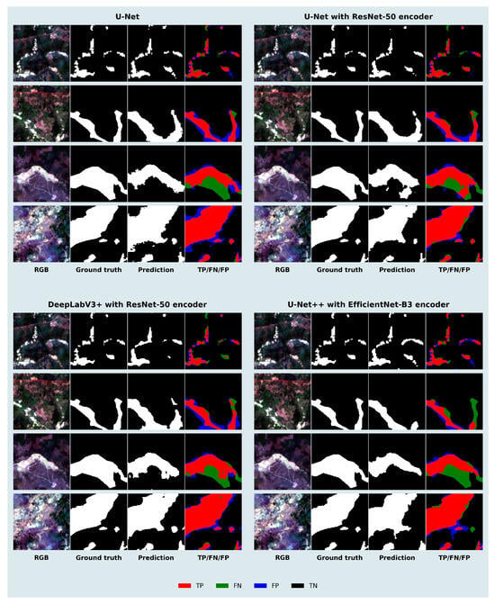
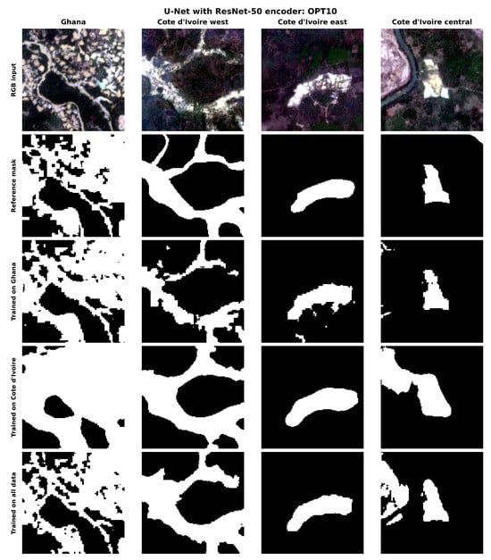
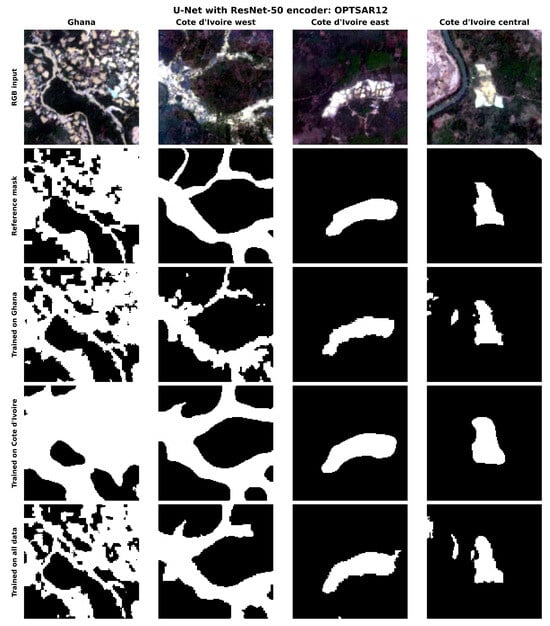
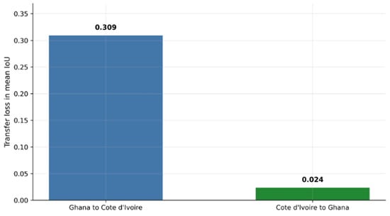
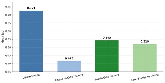
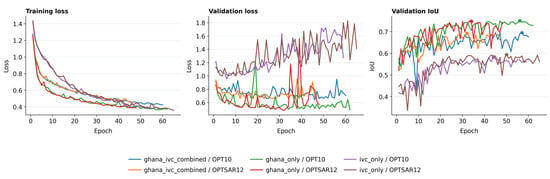
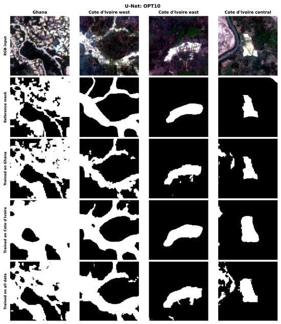
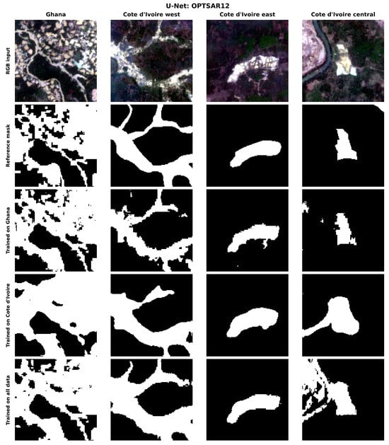
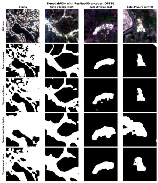
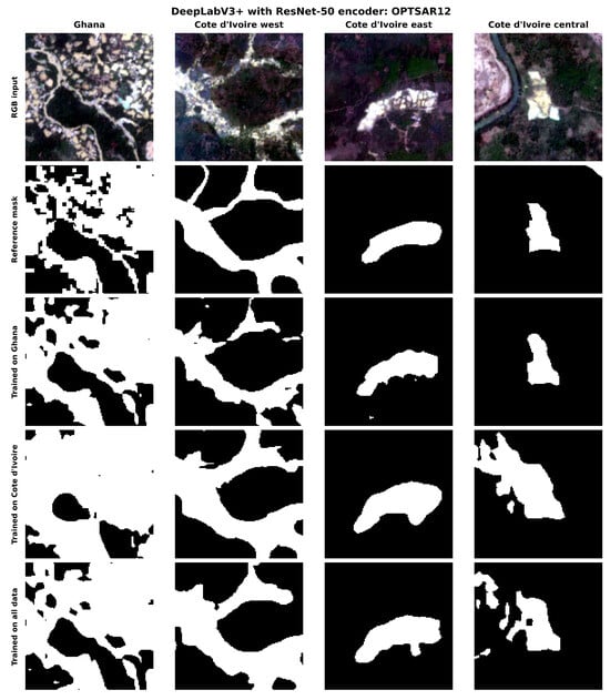
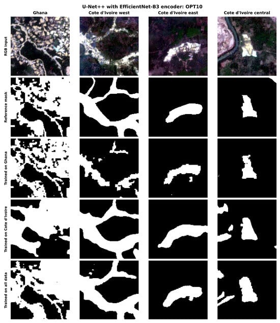
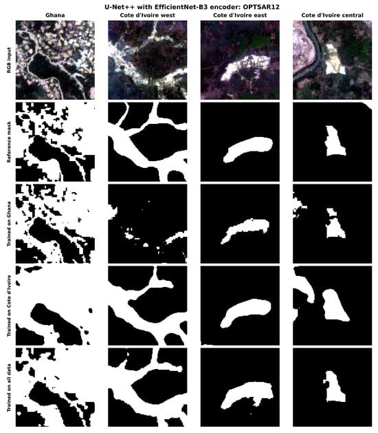
Artisanal and small-scale mining (ASM) is expanding across West Africa, driving deforestation, water contamination, and land degradation that require scalable monitoring approaches. Deep learning (DL) models applied to Sentinel imagery have shown acceptable performance for ASM mapping within individual countries, but their ability to transfer across national boundaries remains poorly understood. This study evaluates four DL segmentation models for ASM mapping in Ghana and Côte d’Ivoire, two major gold-producing countries with contrasting mining landscapes. The models were trained under three geographic scenarios of Ghana only, Côte d’Ivoire only, and both countries combined, using the SmallMinesDS benchmark dataset for Ghana and a newly compiled dataset for Côte d’Ivoire, both combining Sentinel-1 SAR and Sentinel-2 optical imagery. Models performed best when trained and tested on the same country, with U-Net++ (EfficientNet-B3) reaching IoU = 0.748 (F1 = 0.856) on Ghana. On the harder Côte d’Ivoire domain, models trained on Ghana alone transferred poorly (IoU = 0.488, F1 = 0.656), but training on both countries together gave the best result (IoU = 0.568, F1 = 0.724). Overall, the geography of the training data, rather than the model architecture or the use of SAR data, was the main factor driving performance, though some differences may also reflect the datasets being collected at different times.
Full article
(This article belongs to the Special Issue Advances in GeoAI for Earth Observation and Geospatial Data in Geoscience Applications)
►▼
Show Figures

Figure 1
Open AccessArticle
A Dual-Branch LSTM Model for Short-Term Rainfall Forecasting Integrating GNSS-Derived PWV and Surface Meteorological Parameters
by
Mingfang Lin, Liang Zhang, Yang Liu and Jian Kong
Geosciences 2026, 16(8), 309; https://doi.org/10.3390/geosciences16080309 - 2 Aug 2026
Abstract
►▼
Show Figures
Accurate short-term rainfall forecasting is essential for disaster mitigation. Although numerical weather prediction models are widely used, their application to short lead times is constrained by computational demands. Data-driven approaches provide an efficient alternative. To better exploit atmospheric water vapor information, this study
[...] Read more.
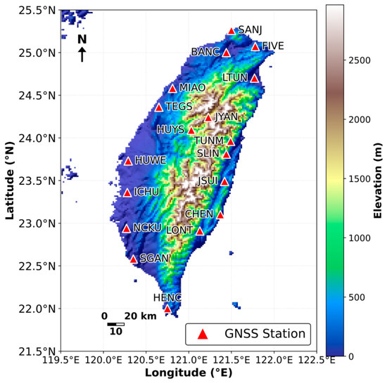
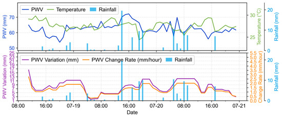
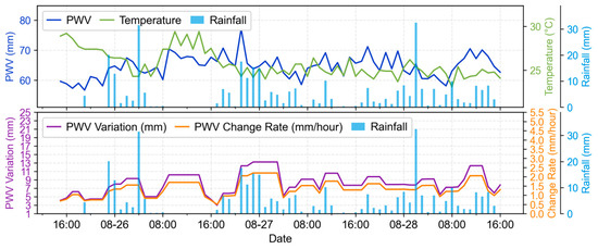
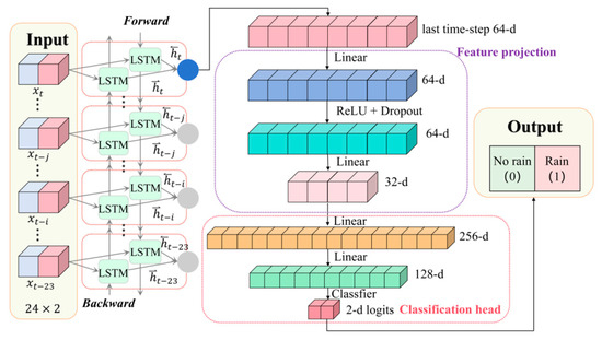
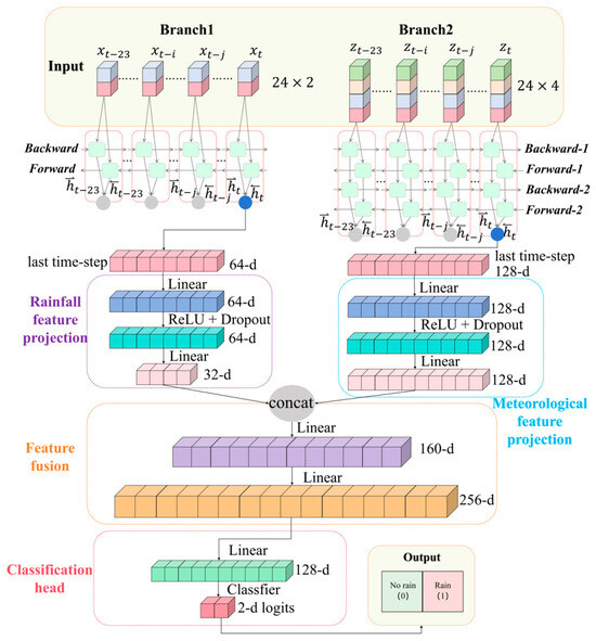
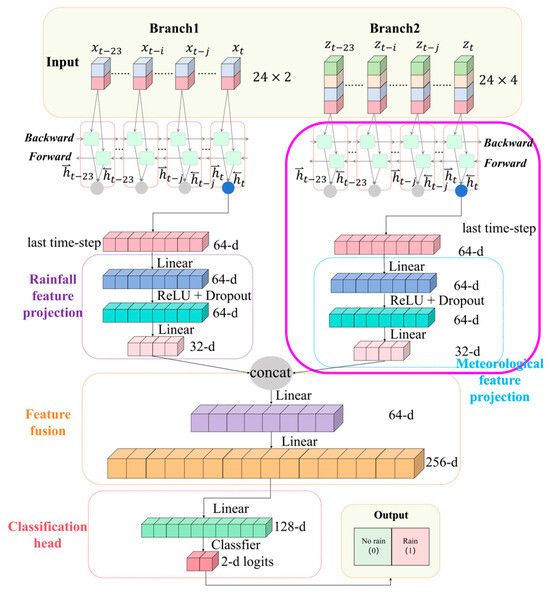
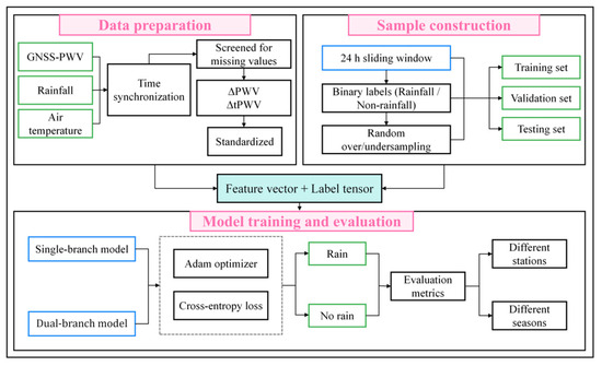
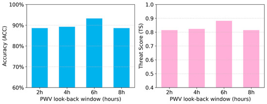
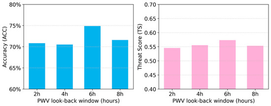
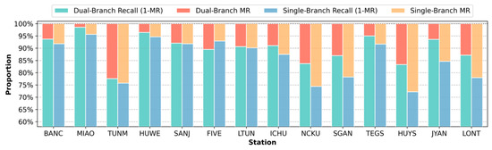
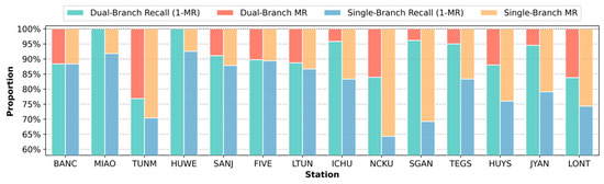
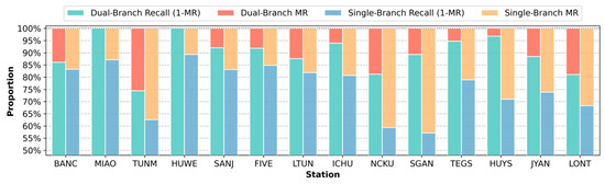
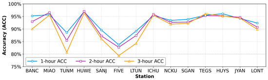
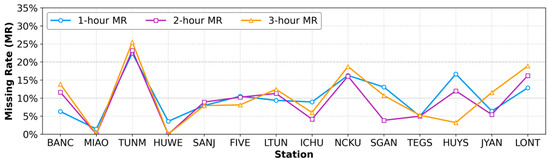
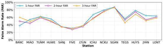
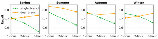
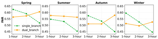
Accurate short-term rainfall forecasting is essential for disaster mitigation. Although numerical weather prediction models are widely used, their application to short lead times is constrained by computational demands. Data-driven approaches provide an efficient alternative. To better exploit atmospheric water vapor information, this study develops a dual-branch long short-term memory (LSTM) model that integrates Global Navigation Satellite System (GNSS)-derived precipitable water vapor (PWV) with surface meteorological parameters for rainfall forecasting. The model processes historical rainfall and meteorological variables through separate branches. Historical rainfall characterizes precipitation persistence, while PWV, PWV variation (ΔPWV), PWV rate of change (ΔtPWV), and air temperature describe atmospheric moisture evolution and thermodynamic conditions before rainfall. The model was evaluated using hourly observations from 18 GNSS-collocated meteorological stations in Taiwan collected during 2018–2019 and compared with a rainfall history-based LSTM baseline model. Results show that the proposed model achieved accuracies of 89–91% and recalls of 88–90% for 1–3 h forecasts. Its advantages became more evident for longer lead times, with Recall and Threat Score increasing by 6–11% and 4–8%, respectively, for 2–3 h forecasts. These findings demonstrate that integrating GNSS-derived PWV with surface meteorological parameters can improve short-term rainfall forecasting.
Full article

Figure 1
Open AccessArticle
Characteristics and Exploration Potential Evaluation of Lower Cambrian Source Rocks in the Southern Keping Area, Tarim Basin
by
Ye Duan, Yongquan Chen, Chengxin Liu, Yan Cheng, Fengguang Xu, Hao Zhang, Bing Zhang, Peng Zhou and Jiayu Jiang
Geosciences 2026, 16(8), 308; https://doi.org/10.3390/geosciences16080308 - 1 Aug 2026
Abstract
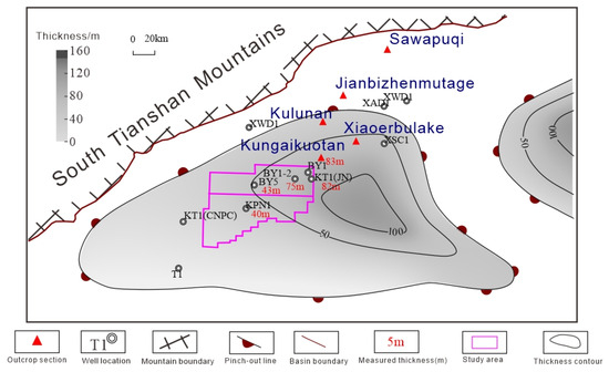
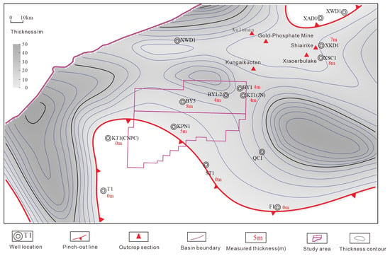
Despite recent Cambrian subsalt gas discoveries in the Keping fault-uplift, northwestern Tarim Basin, organic abundance, type, maturity, and depositional setting of Lower Cambrian source rocks remain poorly documented. We evaluated the Yuertusi and Lower Xiaoerbulake Formations using total organic carbon (TOC) analysis, Rock-Eval
[...] Read more.
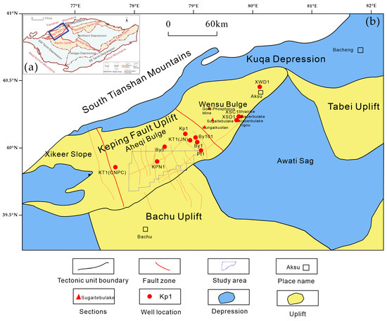
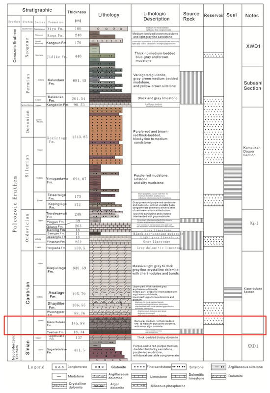
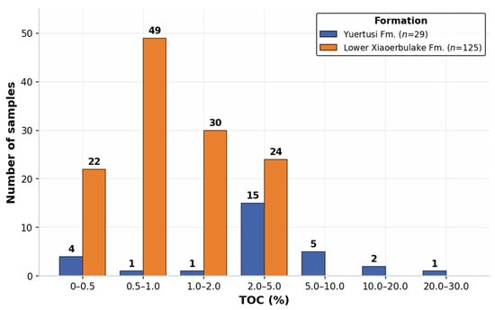
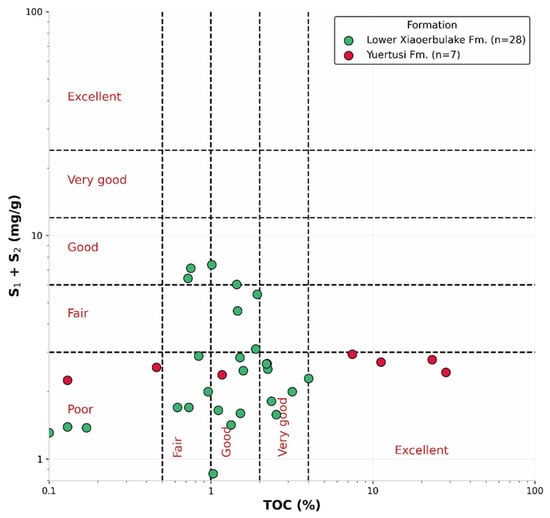
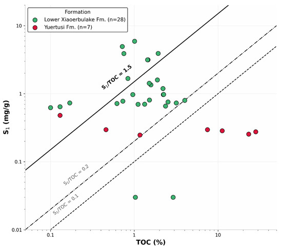
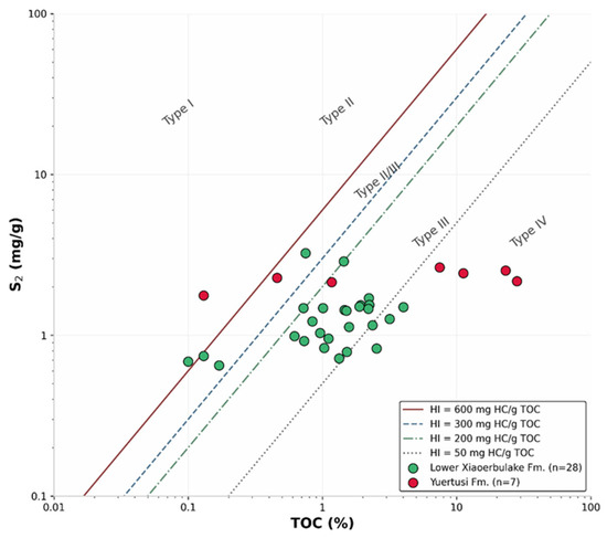
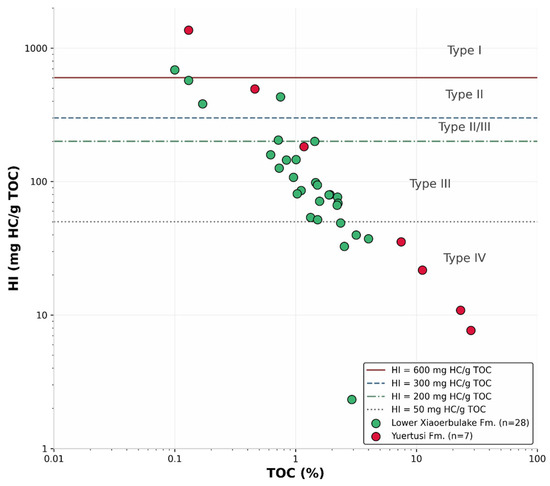
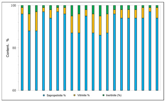
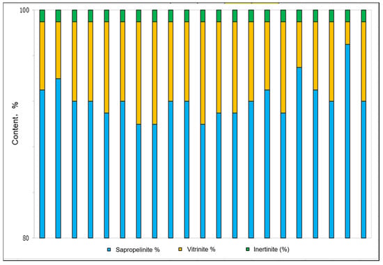
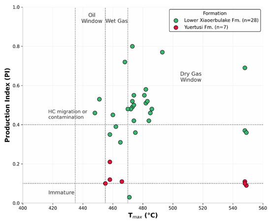
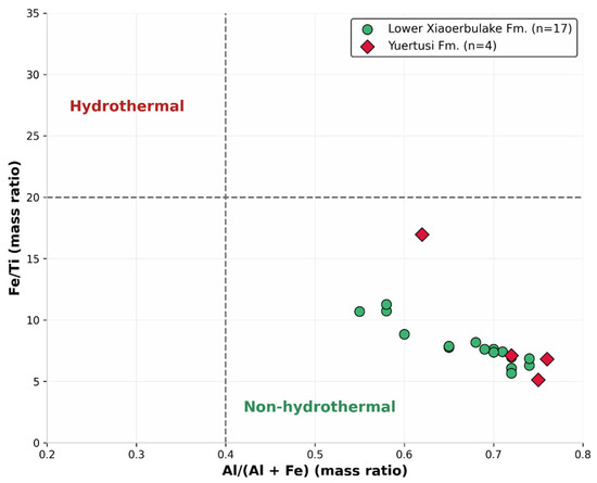
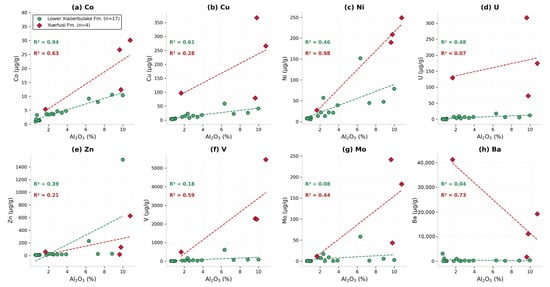
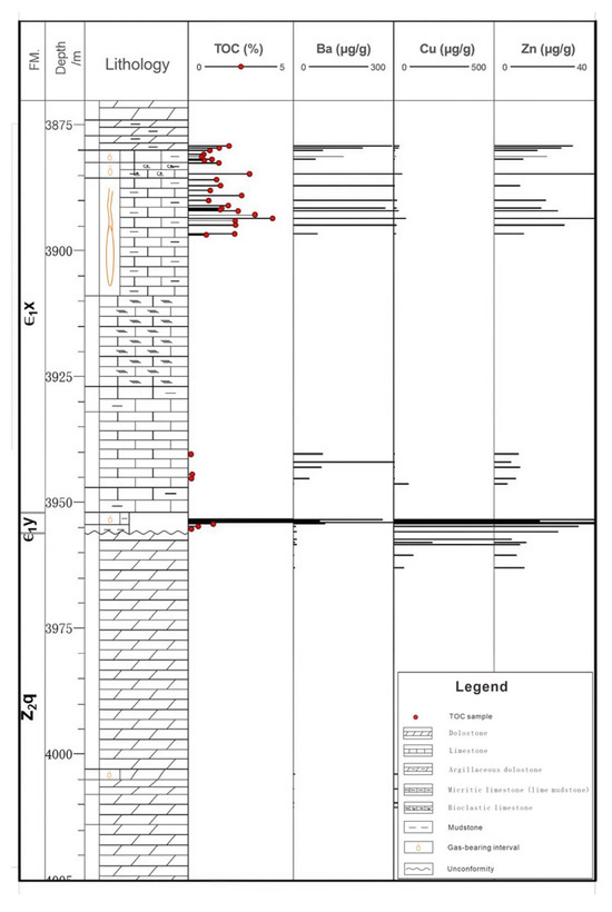
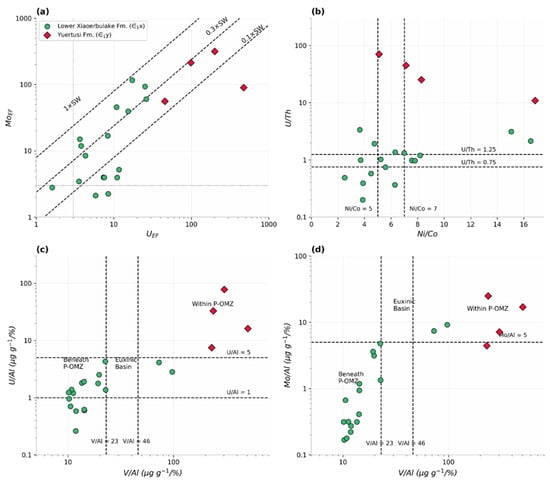
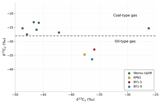
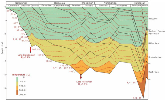
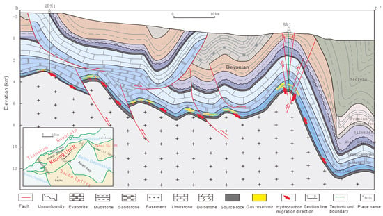
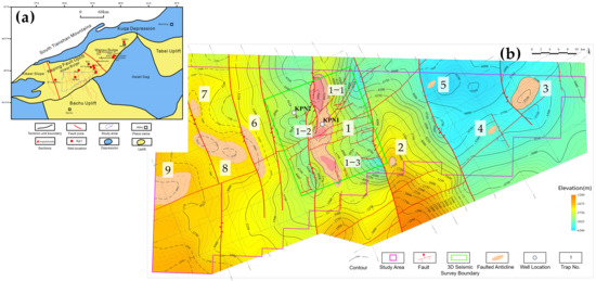
Despite recent Cambrian subsalt gas discoveries in the Keping fault-uplift, northwestern Tarim Basin, organic abundance, type, maturity, and depositional setting of Lower Cambrian source rocks remain poorly documented. We evaluated the Yuertusi and Lower Xiaoerbulake Formations using total organic carbon (TOC) analysis, Rock-Eval pyrolysis, kerogen microscopy, solid bitumen reflectance, X-ray diffraction, and ICP-MS trace-element analysis of samples from 11 wells and 6 outcrops. The Yuertusi Formation is organic-rich in northern Keping (TOC = 0.13–28.20%) but thins and deteriorates southward. The Lower Xiaoerbulake Formation (TOC = 0.10–9.68%; 70–160 m thick) is a widespread, moderate-to-good source rock, challenging the view that the Yuertusi Formation is the only Cambrian source rock. Sapropelinite-dominated kerogen (>80%) indicates Type I–II organic matter; equivalent vitrinite reflectance (2.28–3.50%) confirms overmature, gas-prone rocks. The Yuertusi Formation reflects upwelling-fed high productivity and anoxic–euxinic waters; the Lower Xiaoerbulake Formation, moderately high productivity and dysoxic waters. The subsalt gas is oil-cracked gas from marine sapropelic source rocks of either formation. Chloroform bitumen “A” estimates give in-place gas resources of 1121.4 × 109 m3; the static share for southern Keping (20.1 × 10⁹ m3) understates its dynamic potential. A lower-generation/upper-reservoir, fault-controlled, near-source model favors Trap 1-1 for future drilling.
Full article
(This article belongs to the Special Issue Advances in Oil and Gas Exploration, Resources, and Production in China)
►▼
Show Figures

Figure 1
Open AccessArticle
Strength Equivalence of Two Stiffness Calibrations in Particle Flow Code: An Insight from Micro-Cracking Evolution
by
Jiao Ye, Fujie Dai and Peng Tang
Geosciences 2026, 16(8), 307; https://doi.org/10.3390/geosciences16080307 - 1 Aug 2026
Abstract
Geohazards in rock mass are essentially results of fracturing evolution. Regarding deeper exploration, to better contribute to evaluating and predicting instability, Particle Flow Code (PFC) has gained increasing popularity because of its logical resemblance in simulating rock composition and cracking processes. However, micro-parameter
[...] Read more.
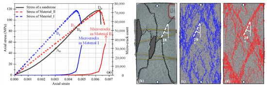
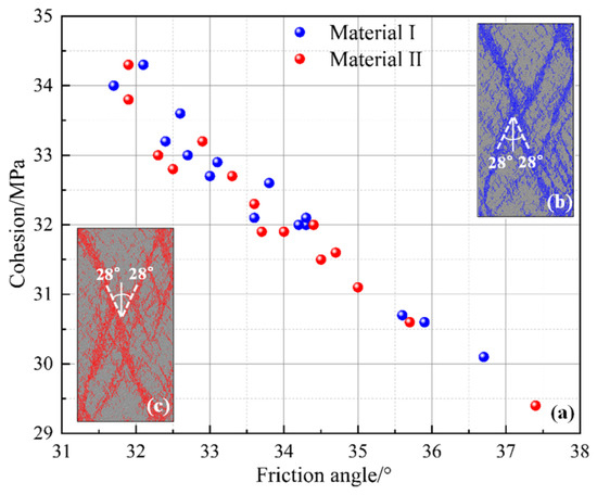
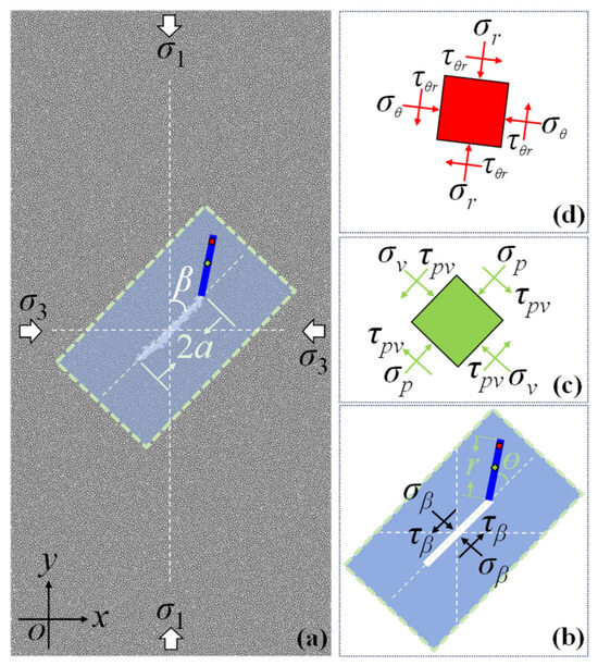
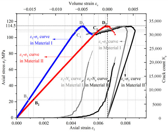
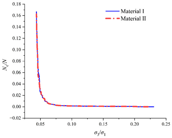
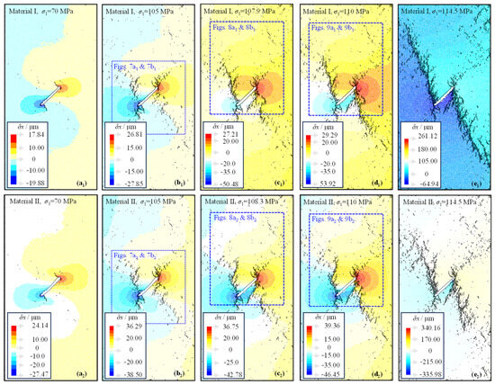
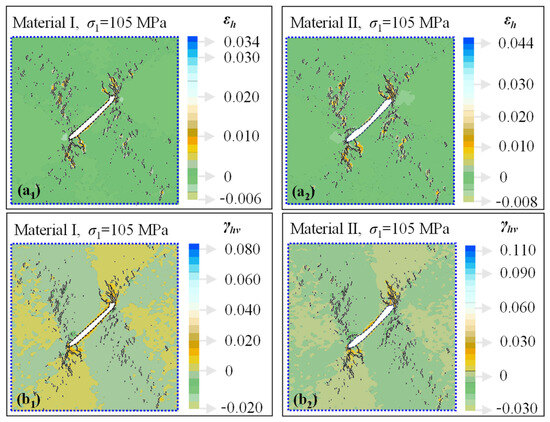
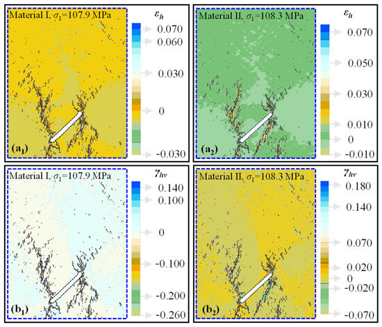
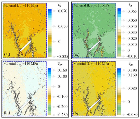
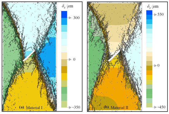
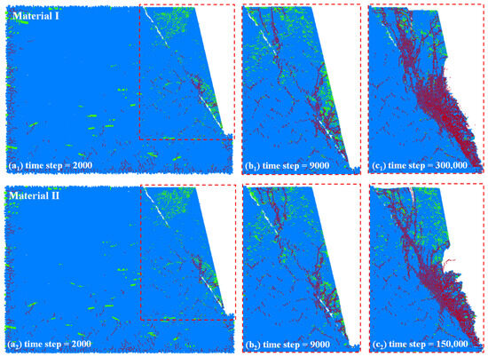
Geohazards in rock mass are essentially results of fracturing evolution. Regarding deeper exploration, to better contribute to evaluating and predicting instability, Particle Flow Code (PFC) has gained increasing popularity because of its logical resemblance in simulating rock composition and cracking processes. However, micro-parameter calibrations in PFC mainly focus on both the peak strength and macroscopic cracks in many previous, as well as current, studies, resulting in the existence of two widely used yet distinct strategies in stiffness calibration. The first is to ensure the consistency of the elastic modulus, and the second is to ensure the deformation consistency at peak-stress states. Do these two stiffness calibrations have a strength equivalence? To explore it, several rock mechanical tests—with and without confining pressures and a pre-existing flaw—were numerically conducted using PFC for two materials produced by these two distinct stiffness-calibration strategies. The results demonstrate that the two stiffness calibrations can yield equivalent strength parameters, including tensile strength, cohesion, and internal friction angle. This strength equivalence could be attributed to the evolutionary process of micro-crack initiation, accumulation, nucleation, and global failure (coalescence). Fracture mechanics analysis demonstrates that crack initiation is independent of the elastic modulus and marginally influenced by Poisson’s ratio, leading to a negligible impact of stiffness-calibration distinction on crack-initiation stress. Subsequent micro-crack accumulation follows a nearly identical non-linear increasing trend, with a high consistency of spatial distributions in stress concentration, displacement gradient, and strain localization. As a result, the near-identical structural logic in micro-crack nucleation results in failure-pattern consensus and governs the macro-scale strength equivalence of these two distinct stiffness-calibration strategies. These findings could help us to better comprehend those previous, as well as current, research results based on the two stiffness-calibration strategies.
Full article
(This article belongs to the Special Issue New Advances in Landslide Mechanisms and Prediction Models)
►▼
Show Figures

Figure 1
Open AccessArticle
Gravity–Magnetic–Seismic Identification Method for Basement Lithology in the XS Exploration Area, South China Sea
by
Jianwei Chen, Xin Wang, Xuanlong Shan, Xiaohan Li, Yujie Zou and Jian Yi
Geosciences 2026, 16(8), 306; https://doi.org/10.3390/geosciences16080306 - 1 Aug 2026
Abstract
The basement lithology in the northern South China Sea remains poorly constrained because of the lack of drilling data, which creates major challenges for predicting bedrock buried-hill reservoirs. This study is based on 2D and 3D seismic data, together with gravity and magnetic
[...] Read more.
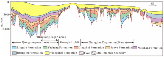
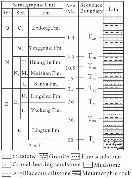
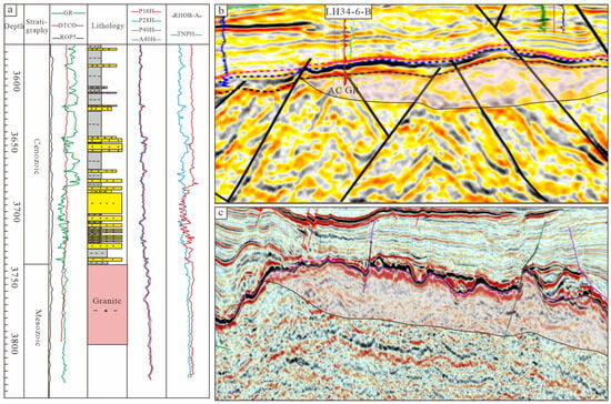
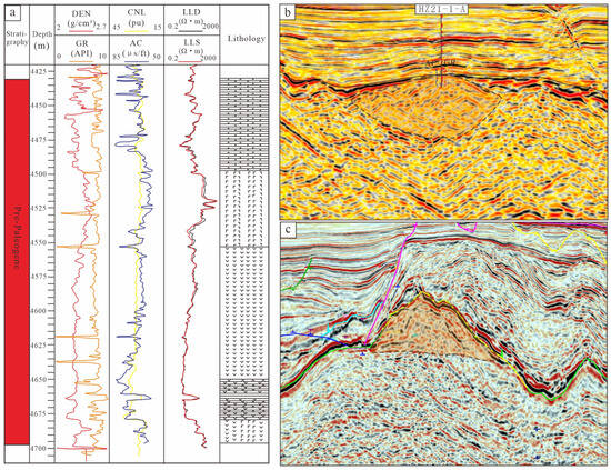
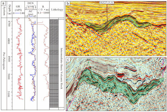
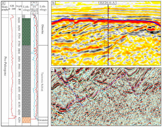
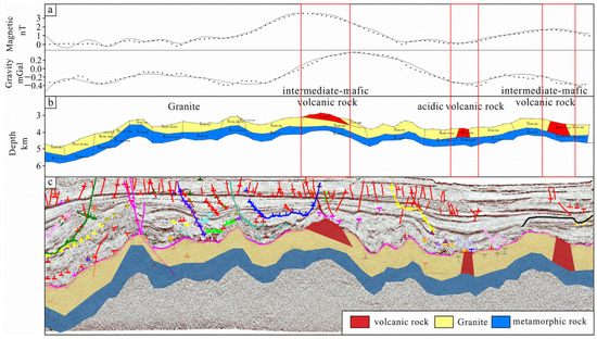
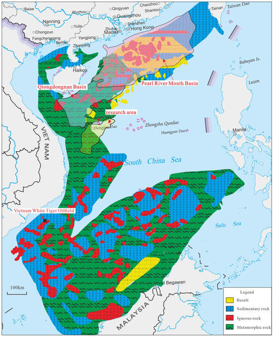
The basement lithology in the northern South China Sea remains poorly constrained because of the lack of drilling data, which creates major challenges for predicting bedrock buried-hill reservoirs. This study is based on 2D and 3D seismic data, together with gravity and magnetic data, and is constrained by previous studies on the regional tectonic framework and lithologic distribution of the northern South China Sea. We investigated the basement lithologic composition of the XS area, established an integrated gravity–magnetic–seismic interpretation framework for basement lithology, and discussed the possible geological controls on basement lithologic distribution. The results show the following: (1) The basement in the study area is mainly composed of granite intrusive bodies, metamorphic rocks, and volcanic rocks. Granite bodies are characterized by irregular to intrusive seismic geometries, strong double-peak reflections at the upper boundary, and weak-amplitude, medium- to low-frequency internal reflections, reflecting their intrusive characteristics. Metamorphic rocks show diverse external seismic geometries, single-peak or weak reflections at the upper boundary, and medium- to strong-amplitude parallel internal reflections that intersect the upper boundary at high angles. Their gravity and magnetic responses show considerable overlap with those of granitic rocks. Volcanic rocks commonly show mound-shaped or lenticular seismic geometries and medium- to strong-amplitude, moderately continuous internal reflections. Intermediate–mafic volcanic rocks are associated with relatively stronger gravity and magnetic anomaly responses, whereas felsic volcanic rocks generally exhibit weak to moderate gravity and magnetic responses. These characteristics provide an integrated seismic–gravity–magnetic constraint framework for basement lithology interpretation in the South China Sea. (2) Integrated gravity–magnetic–seismic interpretation indicates that, near the present top of the pre-Cenozoic basement in the XS area, granite intrusive bodies are the dominant lithology. Metamorphic rocks mainly occur as discontinuous basement remnants in local structural lows or erosional windows, whereas volcanic rocks are mainly distributed near fault intersections or occur as bead-like bodies along fault zones. (3) The distribution of granite intrusive bodies and metamorphic basement is interpreted to be related to Indosinian–Yanshanian magmatic activity, tectonic deformation, and subsequent denudation. Faults formed during Early Yanshanian compression were later reactivated during the Himalayan period and may have acted as magma conduits, promoting the development of volcanic edifices along fault zones.
Full article
(This article belongs to the Topic Formation Mechanism and Quantitative Evaluation of Deep and Ultra-Deep Effective Reservoirs)
►▼
Show Figures

Figure 1
Open AccessArticle
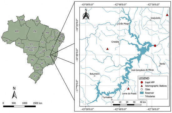
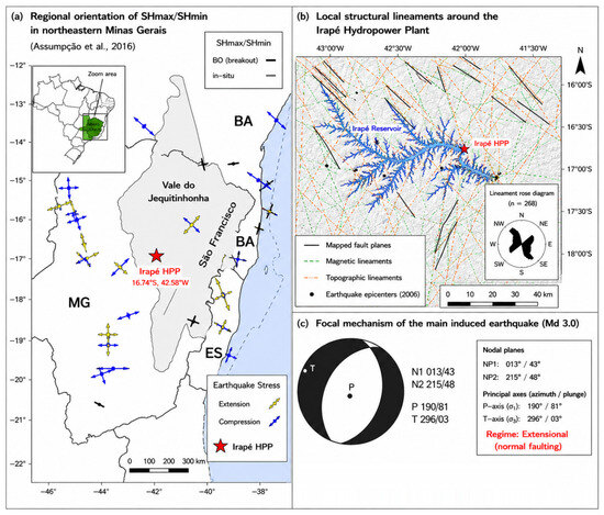
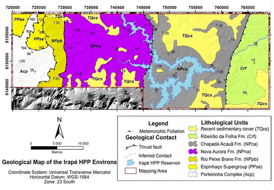
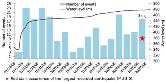
Assessment of Stress Perturbations Induced by Reservoir Loading and Their Compatibility with Reservoir-Triggered Seismicity: The Case of the Irapé Hydropower Plant, Brazil
by
Iarly Vanderlei da Silveira and Gilberto Gomes
Geosciences 2026, 16(8), 305; https://doi.org/10.3390/geosciences16080305 - 1 Aug 2026
Abstract
►▼
Show Figures
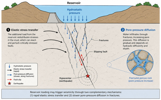
Reservoir-triggered seismicity (RTS) is commonly associated with stress perturbations induced by reservoir loading and pore-pressure diffusion within fractured rock masses. Shortly after the initial impoundment of the Irapé Hydropower Plant (Minas Gerais, Brazil), a sequence of induced earthquakes was recorded, providing an opportunity
[...] Read more.
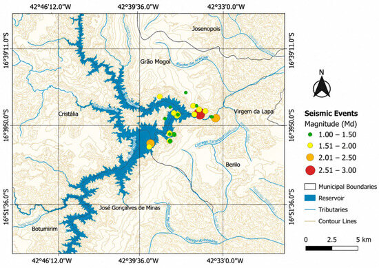
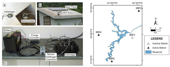
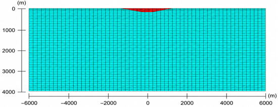
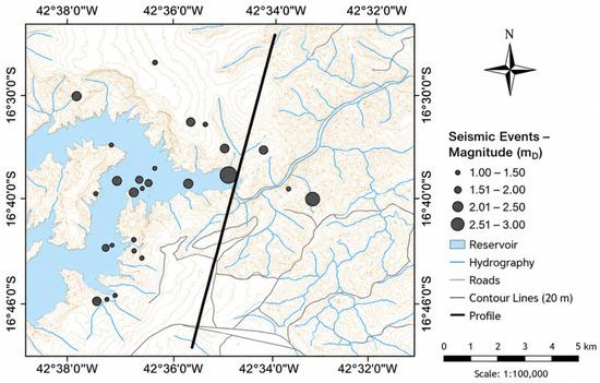
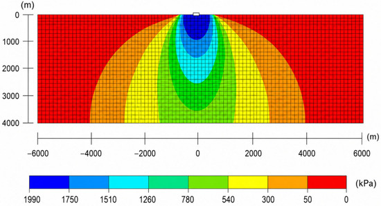
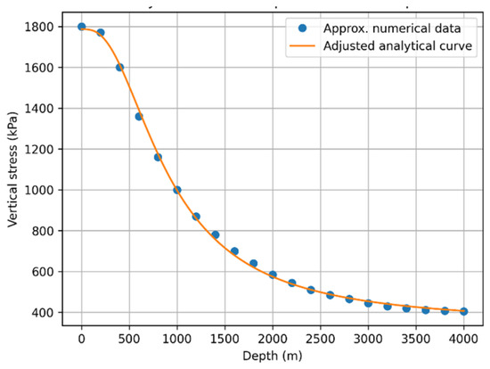
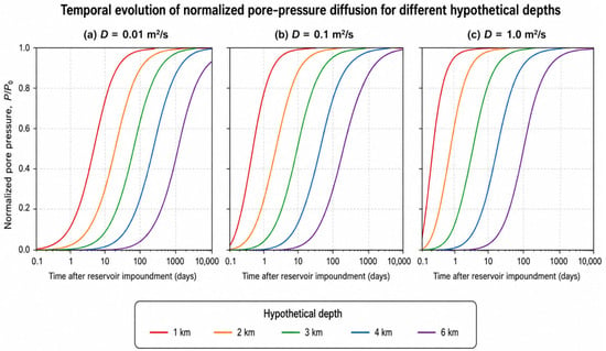
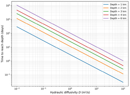
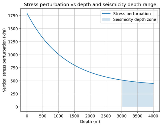
Reservoir-triggered seismicity (RTS) is commonly associated with stress perturbations induced by reservoir loading and pore-pressure diffusion within fractured rock masses. Shortly after the initial impoundment of the Irapé Hydropower Plant (Minas Gerais, Brazil), a sequence of induced earthquakes was recorded, providing an opportunity to investigate the compatibility between reservoir loading and the observed seismic response. This study presents a first-order hydromechanical assessment integrating finite element modelling, analytical elasticity solutions, and pore-pressure diffusion theory to evaluate the spatial distribution of stress perturbations and the characteristic diffusion times associated with reservoir impoundment. A two-dimensional elastic model was developed to simulate stress redistribution induced by the maximum reservoir load, while a parametric diffusion analysis was performed for representative hydraulic diffusivities and hypocentral depth scenarios between 1 and 6 km. Numerical results showed excellent agreement with the analytical elasticity solution (RMSE = 14.36 kPa, MAE = 11.08 kPa, mean relative error = 1.38%, and R2 = 0.999), supporting the reliability of the numerical model. The simulations indicate that vertical stress perturbations decrease from approximately 1.8–2.0 MPa immediately beneath the reservoir to about 0.01–0.1 MPa at kilometer-scale depths, where the recorded seismicity is presumed to occur. The diffusion analysis indicates that pore-pressure propagation to these depths generally requires substantially longer times than the interval between reservoir filling and the onset of seismic activity. Nevertheless, owing to uncertainties in hydraulic diffusivity, fracture connectivity, and hypocentral depth estimates, the diffusion results are interpreted as a first-order sensitivity analysis rather than a site-specific prediction. Overall, the results support the temporal compatibility and physical plausibility of rapid elastic stress redistribution as a potential triggering mechanism, while recognizing that the available geological and seismological data are insufficient to establish a direct causal relationship or demonstrate fault reactivation.
Full article

Figure 1
Journal Menu
► ▼ Journal Menu-
- Geosciences Home
- Aims & Scope
- Editorial Board
- Topical Advisory Panel
- Early Career Editorial Board
- Instructions for Authors
- Special Issues
- Topics
- Sections & Collections
- Article Processing Charge
- Indexing & Archiving
- Editor’s Choice Articles
- Most Cited & Viewed
- Journal Statistics
- Journal History
- Journal Awards
- Society Collaborations
- Conferences
- Editorial Office
Journal Browser
► ▼ Journal BrowserHighly Accessed Articles
Latest Books
E-Mail Alert
News
Topics
Topic in
Applied Sciences, Energies, Geosciences, Geotechnics, Minerals, Eng
Support Theory and Technology of Geotechnical Engineering, 2nd Edition
Topic Editors: Qi Wang, Bei Jiang, Xuezhen Wu, Hongke GaoDeadline: 30 September 2026
Topic in
Applied Sciences, Energies, Geosciences, Minerals
Mechanism, Prevention and Control of Rockburst in Underground Mines
Topic Editors: Anye Cao, Changbin WangDeadline: 31 October 2026
Topic in
Geosciences, Heritage, Remote Sensing, Sensors, Forensic Sciences
Ground Penetrating Radar (GPR) Techniques and Applications, 2nd Edition
Topic Editors: Pier Matteo Barone, Alastair Ruffell, Vincenzo SapiaDeadline: 30 November 2026
Topic in
Drones, Geosciences, JMSE, Remote Sensing
Recent Advances in Iberian Coastal Geomorphology
Topic Editors: Carlos Cabezas Rabadán, Jesus Palomar-Vazquez, Lluis Gomez-PujolDeadline: 31 December 2026
Conferences
Special Issues
Special Issue in
Geosciences
Sedimentary Basin Evolution: Tectonics, Sedimentation and Architecture
Guest Editor: Nikolay BonevDeadline: 30 August 2026
Special Issue in
Geosciences
The Tectonic Origins of Sedimentary Basins: Provenance and Evolution Across Geological Time
Guest Editors: Anna Chiara Tangari, Daniele Cirillo, Emilia Le Pera, Lucia Marinangeli, Francesco BrozzettiDeadline: 31 August 2026
Special Issue in
Geosciences
Worlds of the Solar System: Geological Evolution and Habitability of Planets and Moons
Guest Editor: Alberto G. FairénDeadline: 31 August 2026
Special Issue in
Geosciences
Advances in GeoAI for Earth Observation and Geospatial Data in Geoscience Applications
Guest Editors: Omid Ghorbanzadeh, Pedram GhamisiDeadline: 31 August 2026
Topical Collections
Topical Collection in
Geosciences
Tsunamis: From the Scientific Challenges to the Social Impact
Collection Editors: Alberto Armigliato, Rachid Omira
Topical Collection in
Geosciences
New Advances in Geotechnical Engineering
Collection Editor: Mohamed Shahin