



Topical Advisory Panel applications are now closed. Please contact the Editorial Office with any queries.
-
Estimating the Importance of Floating Surface Material to the Total Phosphorus Transport in Silver Creek, Wisconsin Using Particle Image Velocimetry -
How to Analyze Censored Concentration Data Using Modern Statistical Methods of Survival Analysis: Background and Nonparametric Methods -
From Artificial Structures to Biogenic Habitats: Two-Year Ecological Responses to Eco-Engineered Reefs in a Tourism-Dominated Adriatic Sandy Coast
Journal Description
Water
Water
is a peer-reviewed, open access journal on water science and technology, including the ecology and management of water resources, published semimonthly online by MDPI. Water collaborates with the Stockholm International Water Institute (SIWI). In addition, the American Institute of Hydrology (AIH), Polish Limnological Society (PLS) and Japanese Society of Physical Hydrology (JSPH) are affiliated with Water and their members receive a discount on the article processing charges.
- Open Access— free for readers, with article processing charges (APC) paid by authors or their institutions.
- High Visibility: indexed within Scopus, SCIE (Web of Science), Ei Compendex, GEOBASE, GeoRef, PubAg, AGRIS, CAPlus / SciFinder, Inspec, and other databases.
- Journal Rank: JCR - Q2 (Water Resources) / CiteScore - Q1 (Aquatic Science)
- Rapid Publication: manuscripts are peer-reviewed and a first decision is provided to authors approximately 17.7 days after submission; acceptance to publication is undertaken in 2.8 days (median values for papers published in this journal in the first half of 2026).
- Recognition of Reviewers: Reviewers whose reports are timely and of high quality receive an APC discount voucher for a future publication in an MDPI journal. Become a reviewer.
- Companion journals for Water include: Hydropower and Freshwater.
- Journal Clusters of Water Resources: Water, Journal of Marine Science and Engineering, Hydrology, Resources, Oceans, Limnological Review, Coasts and Hydropower.
Impact Factor:
3.5 (2025);
5-Year Impact Factor:
3.6 (2025)
Latest Articles
Mitigating Low Pressure in Draft Tubes of Pumped-Storage Units by Installing Tailwater Connection Pipes Under Successive Load Rejection Conditions: Mechanism and Effectiveness Analysis
Water 2026, 18(19), 2435; https://doi.org/10.3390/w18192435 (registering DOI) - 30 Sep 2026
Abstract
The large-scale integration of intermittent renewable energy has increased operating-condition transitions in pumped storage hydropower plants, thereby raising the probability of successive load rejection (SLR) and associated hydraulic transient risks. To mitigate the severe low draft tube pressure (DTP) commonly induced by SLR,
[...] Read more.
The large-scale integration of intermittent renewable energy has increased operating-condition transitions in pumped storage hydropower plants, thereby raising the probability of successive load rejection (SLR) and associated hydraulic transient risks. To mitigate the severe low draft tube pressure (DTP) commonly induced by SLR, this study proposes installing a tailwater connection pipe (TWCP) between the draft tubes of adjacent units. The mitigation mechanism and performance are investigated through theoretical modeling and three-dimensional numerical simulations. Results show that the first load-rejecting unit (FLRU) enters the reverse-pump region prematurely and effectively behaves as a normal-rotation pump. This accelerates the discharge reduction in the subsequent load-rejecting unit (SLRU), drives its operating point deeper into the reverse-pump region, and substantially worsens its minimum DTP. With the TWCP, the head difference drives compensating flow from the FLRU to the SLRU, alleviating transient water shortage, reducing discharge and pressure discrepancies between the two tailwater systems, and improving local turbulent flow. The mitigation effect is sensitive to structural parameters: a larger pipe diameter increases flow capacity, while installation closer to the pump-turbines increases the driving head difference. Both measures enhance DTP mitigation, whereas the TWCP has little influence on steady-state flow conditions.
Full article
(This article belongs to the Special Issue The Simulation and Optimization of Hydraulic Performance in Hydropower and Pumped Storage Power Plants)
Open AccessArticle
Distribution-Based Method-Selection Framework for Reservoir Storage Estimation in a Semi-Arid Snow-Fed Basin
by
Serkan Şenocak and Sinan Bazancir
Water 2026, 18(19), 2434; https://doi.org/10.3390/w18192434 (registering DOI) - 30 Sep 2026
Abstract
Closed-form critical period methods for reservoir storage rest on different distributional assumptions and are rarely checked against the failure probability they promise. We develop a distribution-based method-selection framework ending in a synthetic-record simulation of achieved reliability, and apply it with five estimators (Gould–Dincer
[...] Read more.
Closed-form critical period methods for reservoir storage rest on different distributional assumptions and are rarely checked against the failure probability they promise. We develop a distribution-based method-selection framework ending in a synthetic-record simulation of achieved reliability, and apply it with five estimators (Gould–Dincer Normal, Log-Normal and Gamma, Alexander, McMahon–Mein) to 42–55-year records at four stations in the Karasu sub-basin, Türkiye. Akaike weights modestly favour skew-aware distributions, without separating Gamma from Log-Normal, so the closed-form capacity is model-averaged (bootstrap interval roughly ±40%). The Normal (Dincer) formula exceeds the Gamma formula by a fixed 36% at 70% regulation and 5% risk, whereas simulation puts the difference between Normal and Gamma flow processes at 51–101%. On 50,000-year records from the fitted Gamma model, Gamma-based capacities deliver 1.5–4.3% annual failure against the 5% target at 70% regulation but up to 7.9% at 80%, and Normal-based 1.0–2.7% and 3.9–5.6%, respectively. Serial correlation of 0.18–0.21 raises non-zero simulated storage requirements by 4–22% on average. Simulation is a benchmark conditional on the fitted two-parameter models: parameter and model-selection uncertainty give it a 95% interval of 0.3–1.6 times its value at 80% regulation. Closed forms remain diagnostics and starting values; all capacities estimated here are inter-annual carry-over storage.
Full article
(This article belongs to the Section Hydrology)
Open AccessArticle
A Dynamic Assessment Framework for Water Resource Spatial Equilibrium: Structural Imbalances and Convergence Patterns in Anhui Province of China
by
Lijun Chen, Shangming Jiang, Zheng Li and Shiwei Zhou
Water 2026, 18(19), 2433; https://doi.org/10.3390/w18192433 - 30 Sep 2026
Abstract
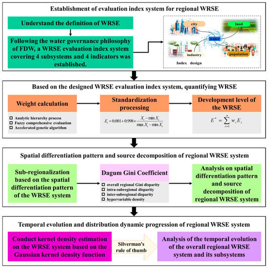
Existing water resource spatial equilibrium (WRSE) evaluations face persistent limitations in identifying structural sources of imbalance and characterizing their dynamic evolutionary trajectories. To address this gap, this study aims to develop a diagnostic framework that quantifies spatial inequity, pinpoints its structural origins, and
[...] Read more.
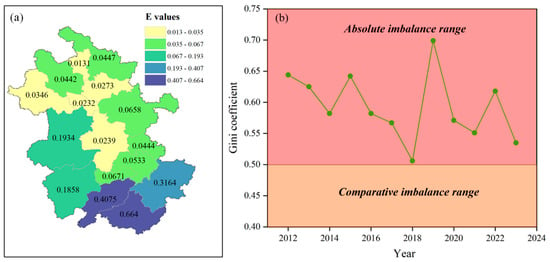
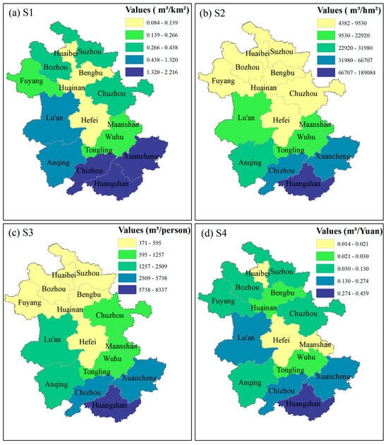
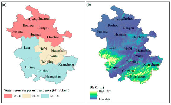
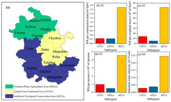
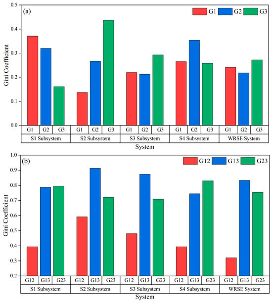
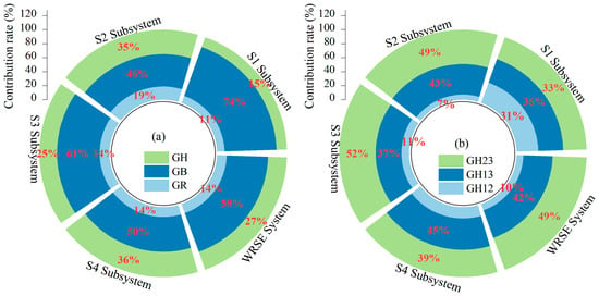
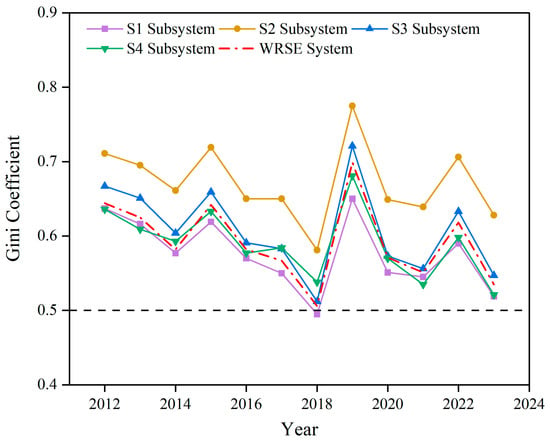
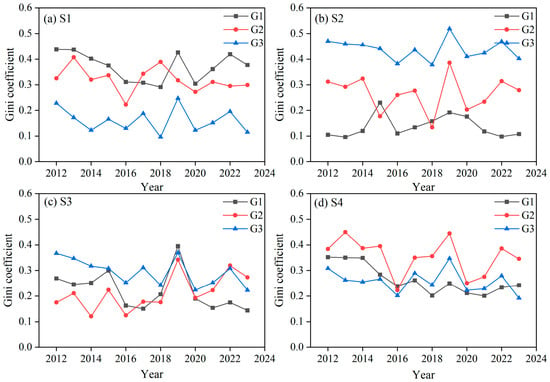
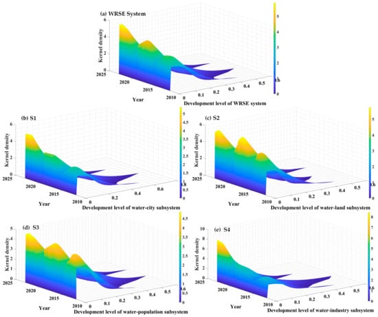
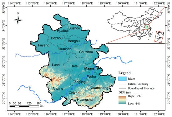
Existing water resource spatial equilibrium (WRSE) evaluations face persistent limitations in identifying structural sources of imbalance and characterizing their dynamic evolutionary trajectories. To address this gap, this study aims to develop a diagnostic framework that quantifies spatial inequity, pinpoints its structural origins, and depicts temporal convergence patterns. Methodologically, we adopt statistical analytical approaches, specifically Dagum Gini coefficient decomposition and kernel density estimation (KDE), and construct a four-subsystem evaluation framework covering water–city, water–land, water–population, and water–industry dimensions. We apply this framework to WRSE analysis in Anhui Province, China, using balanced panel data from 2012 to 2023. Results indicate continuous WRSE improvement, with the overall Gini coefficient declining from 0.644 to 0.535, though the water–land subsystem remains the most imbalanced and slowest-improving bottleneck. Nearly 60% of the total imbalance stems from inter-zonal disparities among three geographically distinct functional zones, while intra-zone differentiation accounts for only 14%. KDE reveals a convergence across all subsystems with heterogeneous rates: the water–industry subsystem converges fastest driven by efficiency gains, whereas the water–land subsystem converges slowest constrained by rigid irrigation demand. This work advances WRSE research from imbalance description to root-cause diagnosis, featuring four-subsystem disaggregation, coupled decomposition–density analysis, and a generalizable inter-zone dominance pattern for climatic transition zones.
Full article
(This article belongs to the Section Water Resources Management, Policy and Governance)
►▼
Show Figures

Figure 1
Open AccessArticle
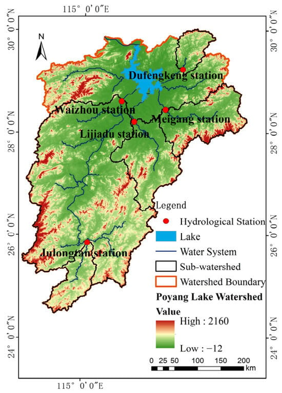
Evaluating the Spatial Generalizability Across Sub-Basins and Temporal Stability of a Reanalysis-Forced SWAT Model: A Case Study of the Poyang Lake Basin
by
Yuesong Zheng, Sha Shi, Xiaojuan Qian, Xiajun Wu, Yao Wu and Shuaibing Wu
Water 2026, 18(19), 2432; https://doi.org/10.3390/w18192432 - 30 Sep 2026
Abstract
Hydrological simulation in uncalibrated sub-basins faces common challenges including limited forcing data quality, low reliability of parameter spatial transfer, and poor long-term simulation stability. Taking the Poyang Lake Basin (approximately 162,200 km2) as the study area, this study aims to systematically
[...] Read more.
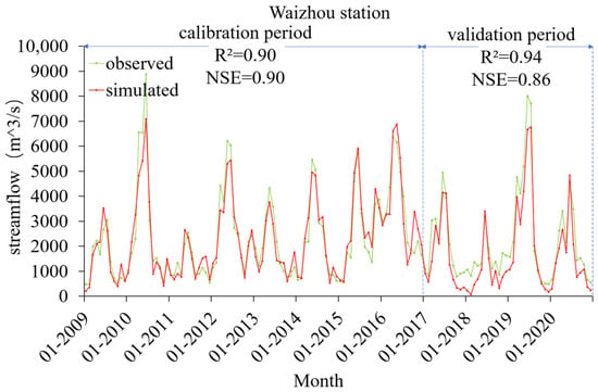
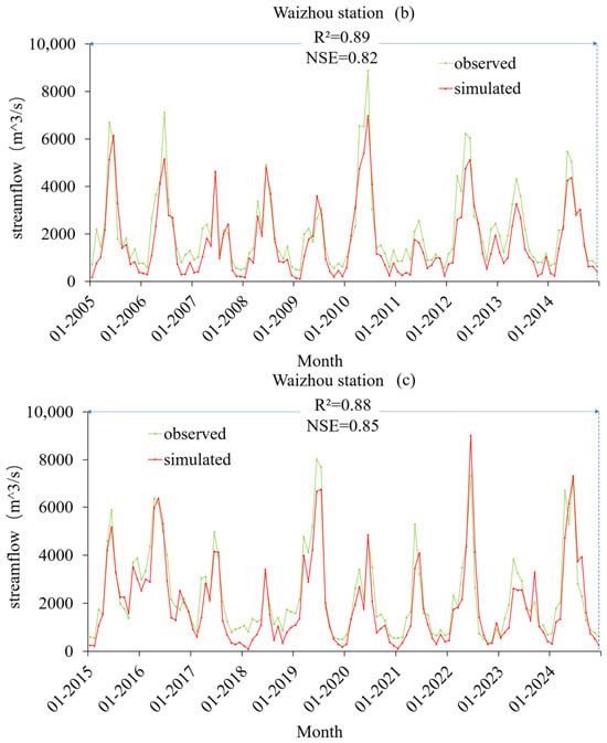
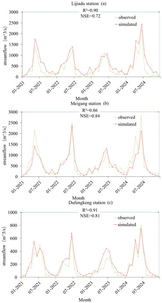
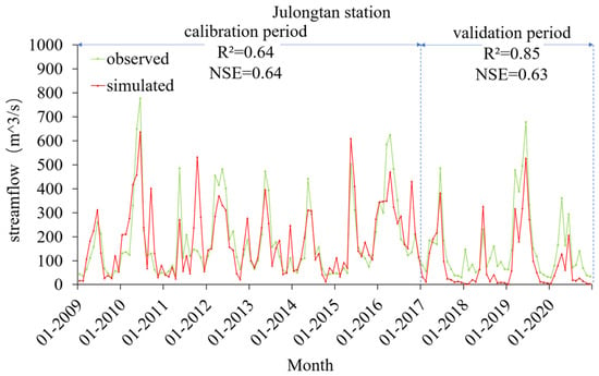
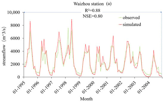
Hydrological simulation in uncalibrated sub-basins faces common challenges including limited forcing data quality, low reliability of parameter spatial transfer, and poor long-term simulation stability. Taking the Poyang Lake Basin (approximately 162,200 km2) as the study area, this study aims to systematically evaluate the spatiotemporal generalization performance of a coupled hydrological model. A SWAT distributed hydrological model was constructed driven by the high-resolution ERA5-Land meteorological dataset. Model calibration was conducted at the Waizhou station, and validation was performed across three sub-basin outlets not used in calibration for spatial transfer testing, as well as over a 30-year period for temporal stability assessment. The results indicate that the model achieved high accuracy at the calibrated plain station, with NSE and R2 consistently above 0.86. Spatial transfer to the three uncalibrated sub-basins yielded NSE and R2 both above 0.7, demonstrating good spatial generalization capability. The 30-year long-term simulation maintained NSE and R2 generally above 0.8, confirming reliable temporal stability. However, systematic runoff underestimation was observed in long-term runs, with a maximum negative PBIAS of −20.68% during 2005–2014, mainly attributable to rainfall resolution limits, static land use assumption, and single-objective calibration trade-offs. Overall, the ERA5-Land–SWAT model shows dependable spatiotemporal extrapolation capability in the Poyang Lake Basin, and can be further improved with higher-resolution precipitation and dynamic land use data for water resources management applications.
Full article
(This article belongs to the Special Issue Intelligent Regulation and Adaptive Management of Complex River Basin Systems)
►▼
Show Figures

Figure 1
Open AccessArticle
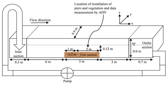
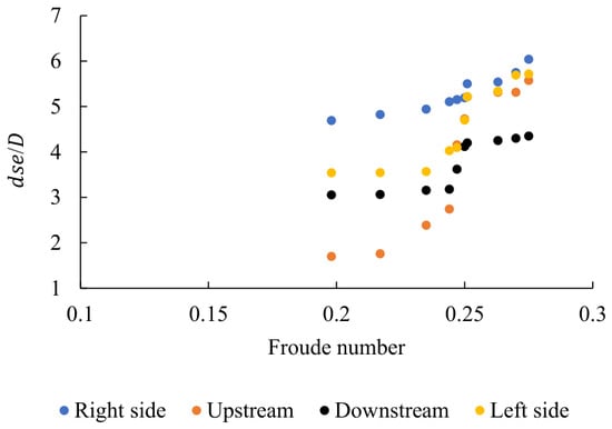
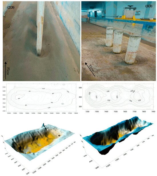
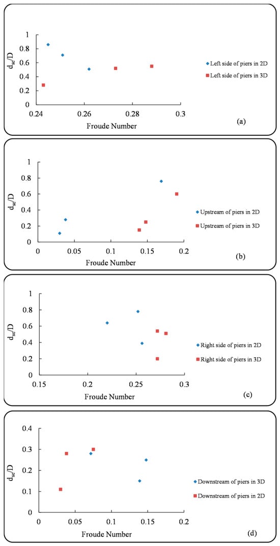
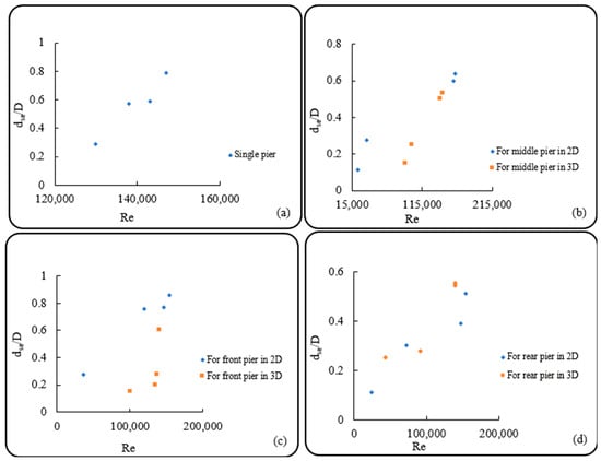
Local Scour Around Elliptical Pier Groups in Non-Uniform Sediment with Submerged Flexible Vegetation
by
Hussam Al Muteri, Hossein Afzalimehr, Radoslav Schugerl, Reza Ahmadi-Niasani and Saeid Okhravi
Water 2026, 18(19), 2431; https://doi.org/10.3390/w18192431 - 30 Sep 2026
Abstract
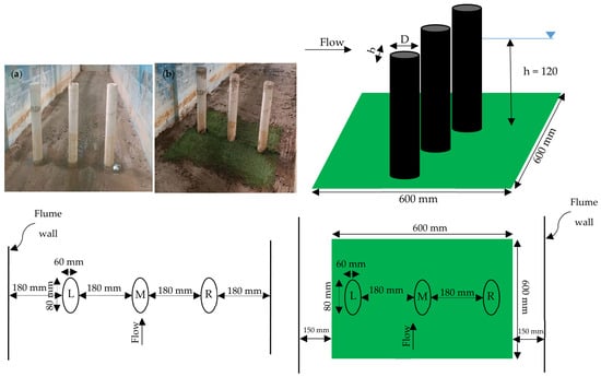
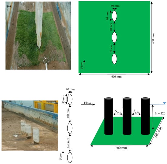
Local scour around bridge-pier groups is governed by interactions among pier geometry, flow interference, and sediment mobility. This study investigates these processes for elliptical pier groups in non-uniform sediment protected by submerged flexible vegetation under steady, clear-water laboratory conditions. Single- and three-pier configurations
[...] Read more.
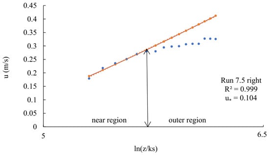
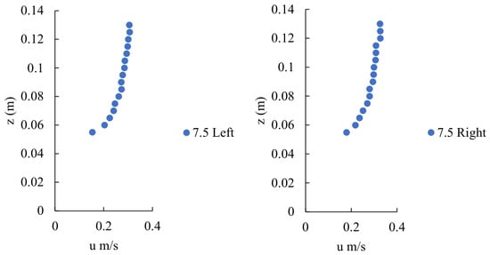
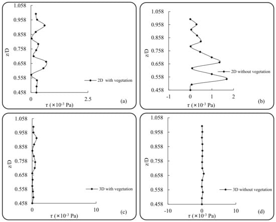
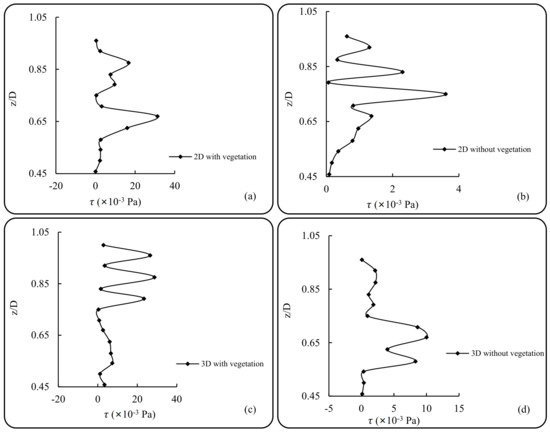
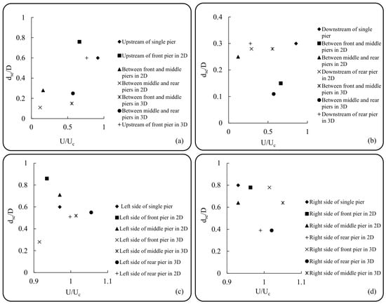
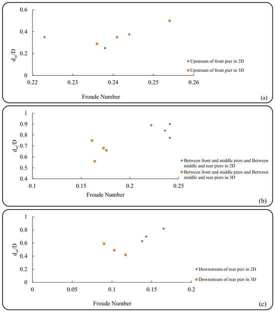
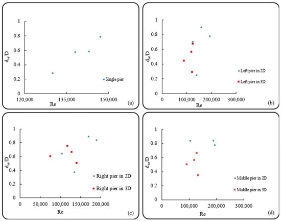
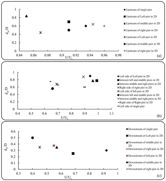
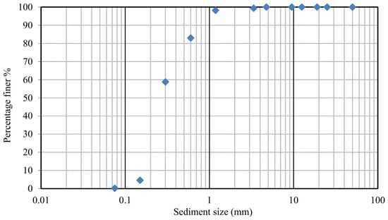
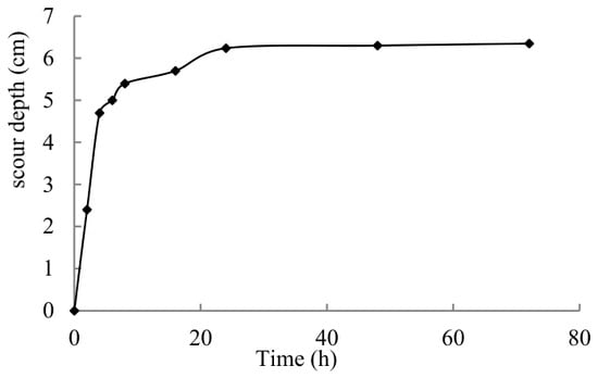
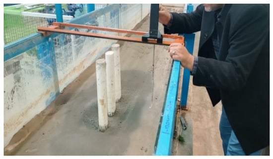
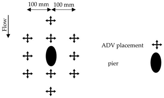
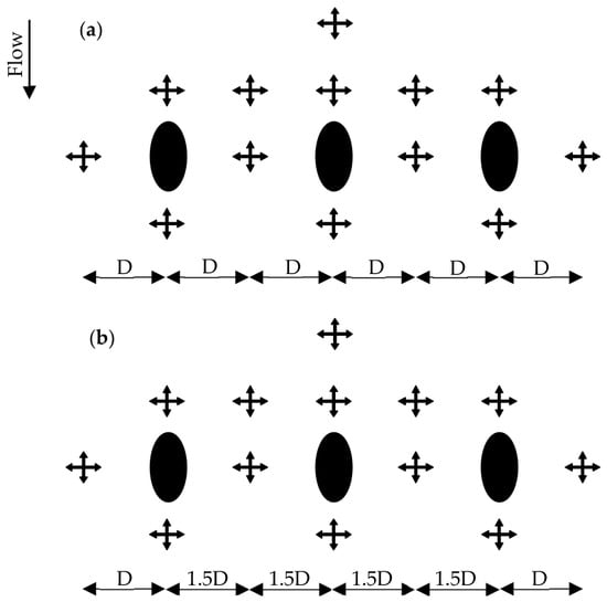
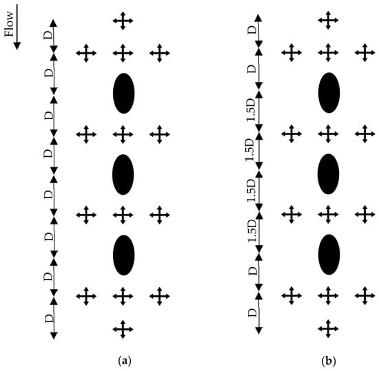
Local scour around bridge-pier groups is governed by interactions among pier geometry, flow interference, and sediment mobility. This study investigates these processes for elliptical pier groups in non-uniform sediment protected by submerged flexible vegetation under steady, clear-water laboratory conditions. Single- and three-pier configurations were tested in tandem and side-by-side arrangements at 2D and 3D (D = pier’s diameter) spacings. Experimental data included velocity profiles, scour morphology, and turbulence characteristics. In tandem groups, strong sheltering at 2D concentrated scour at the front pier (max 69 mm), while rear pier scour was minimal (9 mm). At 3D, sheltering weakened, leading to more independent scour. In side-by-side groups, contraction dominated, with maximum scour decreasing from 72 mm at 2D to 60 mm at 3D. Sediment gradation further moderated erosion through surface armoring. Notably, within the tested densities, the flexible canopy reduced near-bed momentum and bed shear stress toward or below critical sediment-motion thresholds, strongly suppressing scour under the tested laboratory canopy. These findings clarify the coupled roles of pier interference, sediment armoring, and vegetation-induced resistance, advancing nature-based local scour mitigation within the investigated constraints.
Full article
(This article belongs to the Special Issue Numerical Modelling in Coastal, Hydrological and Hydraulic Engineering)
►▼
Show Figures

Figure 1
Open AccessArticle
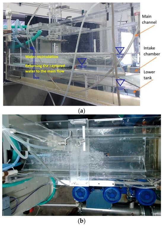
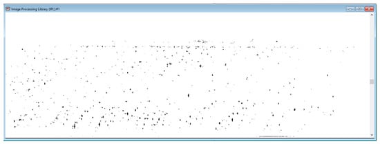
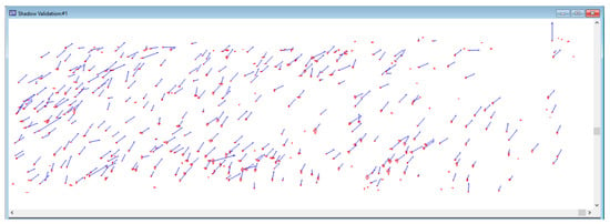
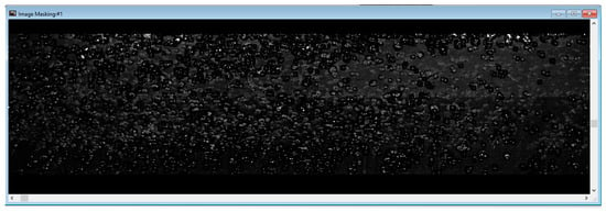
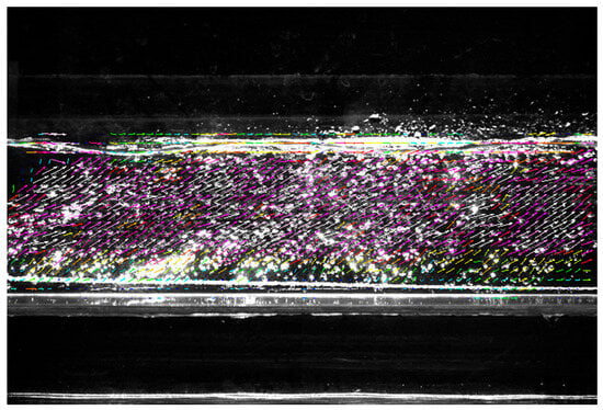
PIV-Based Characterization of the Hydrodynamic Effects of a Bubble Curtain Intended for Fish Guidance
by
Gabriela Cîrciumaru, Paul Alexandru Dancă, Rareș-Andrei Chihaia and Lucia-Andreea El-Leathey
Water 2026, 18(19), 2430; https://doi.org/10.3390/w18192430 - 30 Sep 2026
Abstract
Bubble curtains are non-physical fish-guidance devices that modify the hydrodynamic and acoustic environment near water intakes. This study quantified the liquid-phase velocity field generated by a bubble curtain placed in the vicinity of a water intake in a laboratory open-channel testing rig using
[...] Read more.
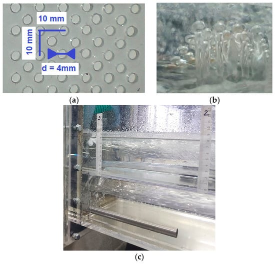
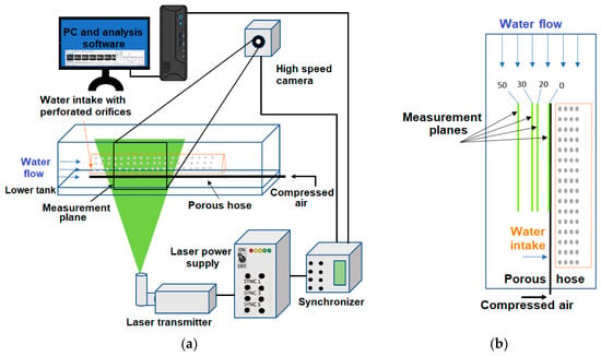
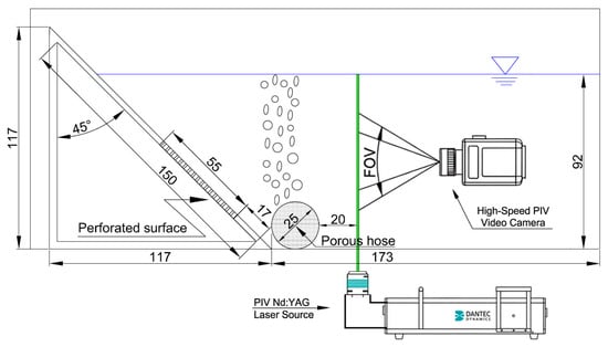
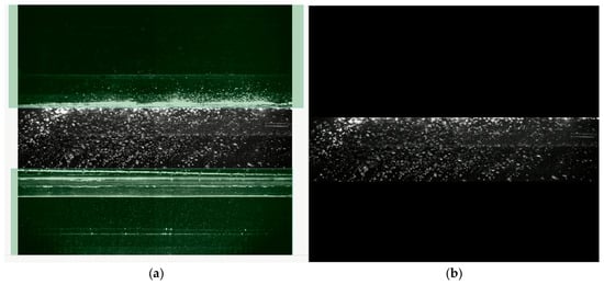
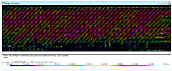
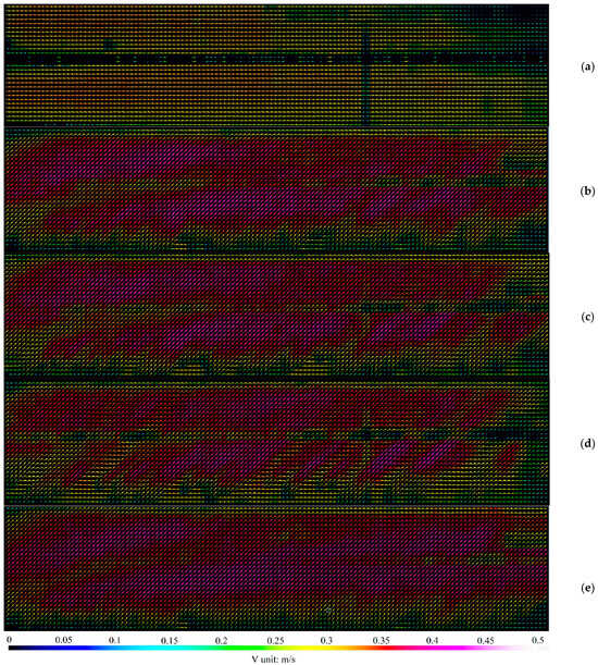
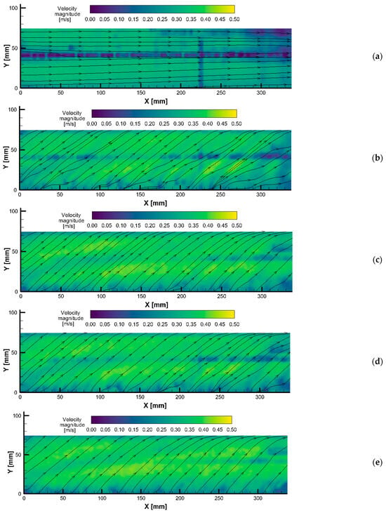
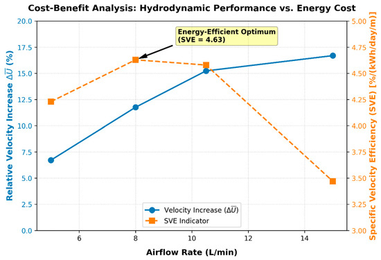
Bubble curtains are non-physical fish-guidance devices that modify the hydrodynamic and acoustic environment near water intakes. This study quantified the liquid-phase velocity field generated by a bubble curtain placed in the vicinity of a water intake in a laboratory open-channel testing rig using planar Particle Image Velocimetry (PIV). Measurements were carried out at a background water velocity of 0.33 m/s for air-injection rates of 0, 5, 8, 10.5, and 15 L/min. Velocity fields were obtained at distances of 0, 20, 30, and 50 mm from the porous hose, with detailed analysis performed at 20 mm. Bubble regions were identified and masked before liquid-phase image correlation. Air injection modified the local velocity direction and produced localized velocity increases, with a maximum local liquid-phase velocity magnitude of approximately 0.42 m/s. Relative to the no-airflow reference velocity of 0.33 m/s, the spatially averaged velocity magnitude increased by approximately 6.7%, 11.8%, 15.2% and 16.7% at airflow rates of 5, 8, 10.5 and 15 L/min, respectively; however, the incremental increase between consecutive airflow conditions decreased from approximately 4.7% between 5 and 8 L/min to 3.1% between 8 and 10.5 L/min and 1.3% between 10.5 and 15 L/min. The spatially averaged velocity magnitude increased with airflow rate, while the incremental response decreased progressively at higher air-injection rates. Thus, 8 L/min represents a candidate energy-efficient operating condition under the tested laboratory conditions. The results provide hydraulic information relevant to subsequent fish-behavior experiments; however, fish-guidance performance cannot be inferred from the present hydrodynamic measurements alone. The results provide a hydraulic basis for designing subsequent fish-behavior experiments. Because no fish were present during the measurements, the study does not assess fish attraction, avoidance, movement restriction, passage, entrainment, or guidance efficiency. Fish-guidance performance cannot be inferred from the present hydrodynamic measurements alone.
Full article
(This article belongs to the Special Issue Advanced Fluid Mechanics in Hydraulic Engineering: Turbulence, Multiphase Flows, and Sediment Dynamics)
►▼
Show Figures

Figure 1
Open AccessArticle
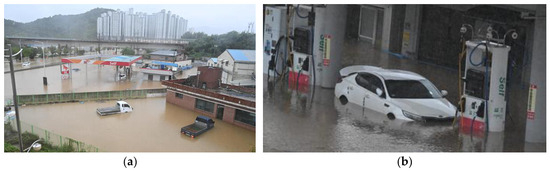
Experimental Investigation of an Inclined Horizontal Submersible Pump with a Preemptive Operation Strategy for Mitigating Urban Pluvial Flooding: A Full-Scale Validation Approach
by
Jeongho Kim, Su-Won Son and Sunghoon Hong
Water 2026, 18(19), 2429; https://doi.org/10.3390/w18192429 - 30 Sep 2026
Abstract
Climate change and urbanization have intensified extreme rainfall, exacerbating urban pluvial flooding risks. Conventional pumps require substantial submergence to suppress air-entraining vortices, delaying early-stage drainage. This study evaluated an inclined horizontal submersible pump (IHSP) with an anti-vortex suction cover designed for preemptive drainage
[...] Read more.
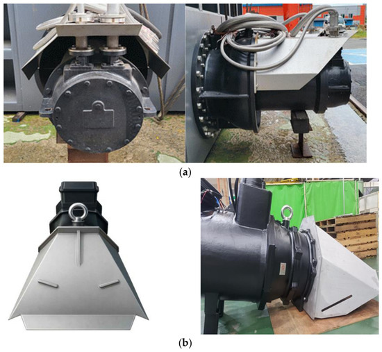
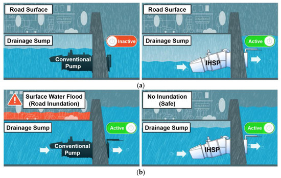
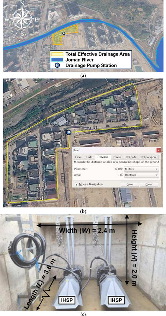
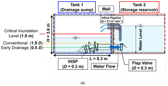
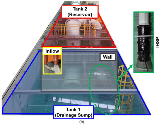
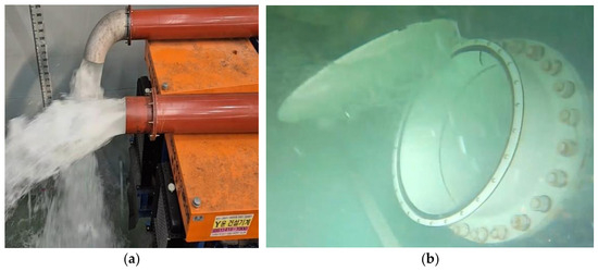
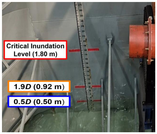
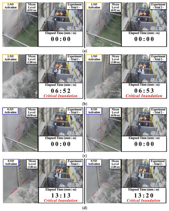
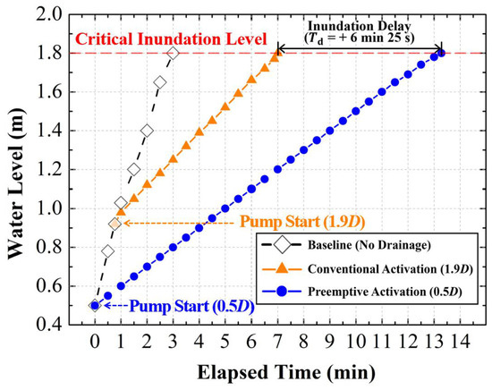
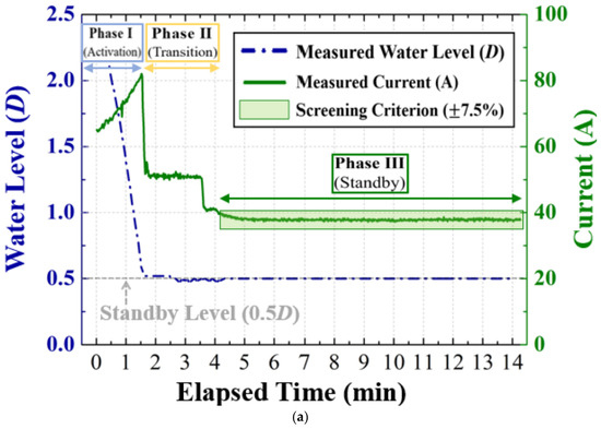
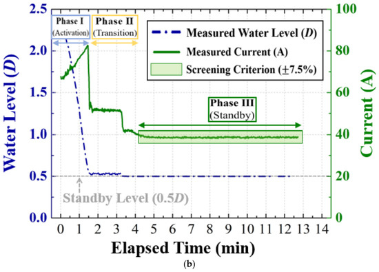
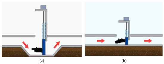
Climate change and urbanization have intensified extreme rainfall, exacerbating urban pluvial flooding risks. Conventional pumps require substantial submergence to suppress air-entraining vortices, delaying early-stage drainage. This study evaluated an inclined horizontal submersible pump (IHSP) with an anti-vortex suction cover designed for preemptive drainage at an ultra-low water level (0.5D). A 390-ton full-scale facility simulated an extreme inflow of 21.0 m3 min−1. Compared to conventional activation at 1.9D, preemptive operation extended the time to reach the critical inundation level (1.80 m) from 6 min 52 s to 13 min 17 s, yielding an observed macroscopic delay of 6 min 25 s in the experimental tank. Geometrically scaling this by the tank-to-field area ratio (4.67) yields an idealized theoretical reference of 1 min 22 s, which serves as a conceptual baseline rather than a deterministic field prediction. During continuous low-load standby, motor-current deviations remained tightly constrained (maximum 2.07%), well within the study-specific ±7.5% screening criterion while eliminating chattering-induced electromechanical stress. Furthermore, an 11-year life cycle cost assessment revealed a 33.2% expenditure reduction, primarily from eliminating deep-sump excavations. These findings demonstrate that the IHSP provides stable low-water-level operation and preemptive drainage for enhanced urban flood response.
Full article
(This article belongs to the Section Urban Water Management)
►▼
Show Figures

Figure 1
Open AccessArticle
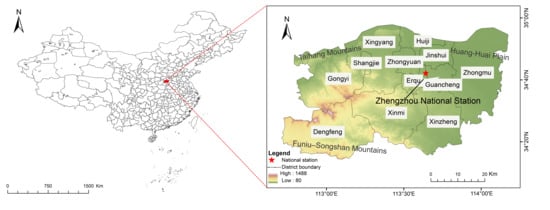
Urban Flood Resilience in Climate Transition Zones: Diagnosing a Precipitation Regime Shift Towards Re-Benchmarking Design Standards—Evidence from Zhengzhou, China
by
Chunxia Zhang, Ziyu Wang and Nana Kong
Water 2026, 18(19), 2428; https://doi.org/10.3390/w18192428 - 30 Sep 2026
Abstract
Mid-latitude climate transition zones (30–35° N), where monsoon, westerly, and orographic forcing interact, face reorganizing precipitation regimes; yet, urban flood design standards there remain calibrated to stationary historical statistics. Using Zhengzhou, China, as a representative case, we reconstruct its precipitation regime from a
[...] Read more.
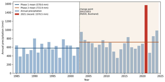
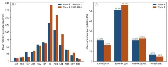
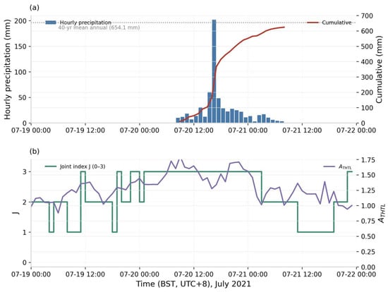
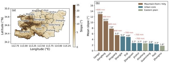
Mid-latitude climate transition zones (30–35° N), where monsoon, westerly, and orographic forcing interact, face reorganizing precipitation regimes; yet, urban flood design standards there remain calibrated to stationary historical statistics. Using Zhengzhou, China, as a representative case, we reconstruct its precipitation regime from a homogenous 40-year monthly record (1985–2024) and diagnose the July 2021 “7·20” event through a thermal saturation–water-vapor surplus–terrain locking (THTL) framework built on ERA5 environmental fields (used only diagnostically, strictly separated from ground-truth rainfall), combined with the official design-benchmark audit and a four-event intensity–impact record (2021–2025) used as initial anchors. Pettitt and Buishand tests consistently locate a regime transition around 2002/2003: the mean annual precipitation rose by 23.7% and the extreme-month frequency nearly doubled, while excluding 2021 shows the variability surge is dominated by that single year. The “7·20” event (624.1 mm in 24 h; record 201.9 mm h−1) overloaded the drainage system by 1.6–2.5 times its design basis, with failures cascading through the metro, tunnel, and reservoir systems; peak accumulations occurred over the foothill–urban transition belt, consistent with terrain locking. The study does not re-compute design return periods; rather, it assembles the evidence base towards re-benchmarking design standards in transition zones—regime-aware, non-stationary design updating coupled with mechanism-based early warning—with quantitative non-stationary return-period reassessment defined as the essential next step.
Full article
(This article belongs to the Section Urban Water Management)
►▼
Show Figures

Figure 1
Open AccessArticle
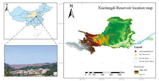
Development of an Agent-Powered Decision Support System for Real-Time Flood Control Consultation at the Xiaolangdi Reservoir
by
Zhenfan Wang, Xindai An, Zeliang Dong, Chunlei Jia, Wei Wang and David Benson
Water 2026, 18(19), 2427; https://doi.org/10.3390/w18192427 - 30 Sep 2026
Abstract
Frequent extreme floods and the limitations of traditional manual consultation—information latency, knowledge fragmentation, and experience-dependent reasoning—create an urgent need for intelligent flood control decision support. To address the complex hydrological conditions and urgent consultation demands involved in flood control decision-making at the Xiaolangdi
[...] Read more.
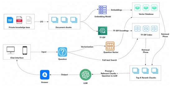
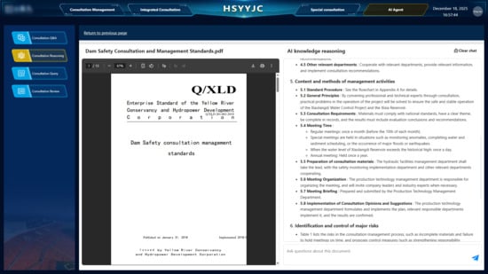
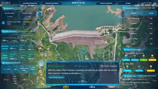
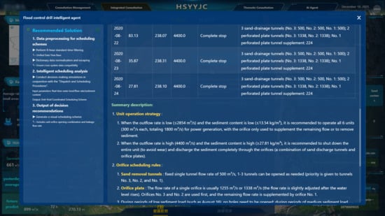
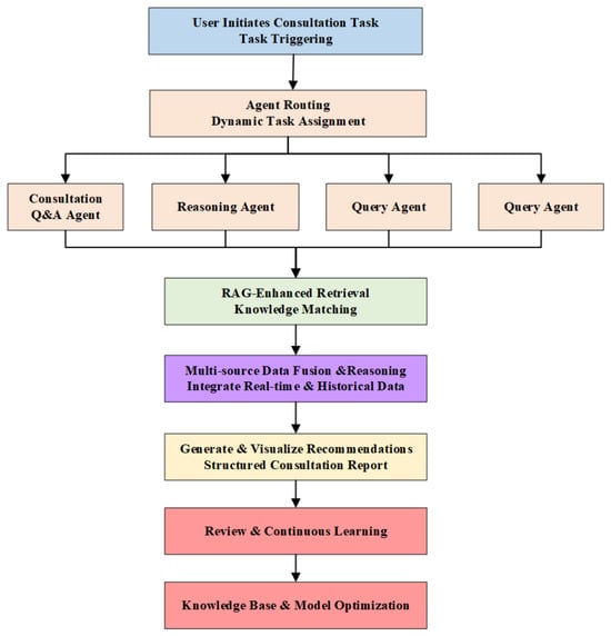
Frequent extreme floods and the limitations of traditional manual consultation—information latency, knowledge fragmentation, and experience-dependent reasoning—create an urgent need for intelligent flood control decision support. To address the complex hydrological conditions and urgent consultation demands involved in flood control decision-making at the Xiaolangdi Reservoir, this study develops an intelligent decision support system that enhances emergency response capabilities through the integration of advanced artificial intelligence technologies. The system integrates a multi-agent architecture with Retrieval-Augmented Generation (RAG) and Large Language Models (LLMs) to create a comprehensive consultation platform. It incorporates multiple specialized agents, including data analysis agents, consultation reasoning agents, and consultation querying agents, which collaboratively process real-time hydrological data, historical flood records, and operational constraints through carefully designed prompt chains. The RAG component enables efficient retrieval of relevant historical cases and technical specifications from the knowledge base, while the LLM engine generates contextualized consultation suggestions and operational recommendations. Practical deployment demonstrates that the system significantly improves the timeliness of flood control decision-making by substantially reducing consultation time. The prompt engineering framework, incorporating domain-specific templates and adaptive reasoning mechanisms, ensures that the generated consultation advice complies with reservoir operational standards and safety protocols. By providing a scalable intelligent consultation platform, this research substantially enhances decision-making efficiency and reliability during emergency flood events, promoting digital transformation in flood management practices.
Full article
(This article belongs to the Special Issue "Watershed–Urban" Flooding and Waterlogging Disasters, 2nd Edition)
►▼
Show Figures

Figure 1
Open AccessSystematic Review
Monitoring of Suspended Sediment Concentration by Alternative Methods: Scientific and Technological Trends and Application Challenges
by
Rhavel Salviano Dias Paulista, Daniela Castagna, Luzinete Scaunichi Barbosa, Daniela Roberta Borella, Frederico Terra de Almeida and Adilson Pacheco de Souza
Water 2026, 18(19), 2426; https://doi.org/10.3390/w18192426 - 29 Sep 2026
Abstract
This study presents an integrative review of the methods used to estimate and monitor suspended sediment concentration (SSC), an important parameter for understanding erosive processes, river dynamics, reservoir lifespan, and water quality. The search in the Scopus, Web of Science, and SciELO databases
[...] Read more.
This study presents an integrative review of the methods used to estimate and monitor suspended sediment concentration (SSC), an important parameter for understanding erosive processes, river dynamics, reservoir lifespan, and water quality. The search in the Scopus, Web of Science, and SciELO databases covered studies published between 1992 and 2025. Of the 452 records identified, 269 were considered eligible after removing duplicates. The studies were grouped into traditional methods, optical, acoustic, remote sensing, optical–acoustic integrations, uncommon methods, and parallel measurements. Traditional methods predominated (95 studies), followed by remote sensing (84), optical (40), and acoustic (17). Traditional methods are reliable but require high logistical effort and have low temporal resolution. Optical sensors allow continuous monitoring, although they require local calibration. Acoustic methods better represent the vertical and transversal distribution of SSC but are sensitive to particle characteristics. Remote sensing expands spatial and temporal coverage but depends on image resolution and atmospheric conditions. Therefore, it is concluded that no method is universally superior, and the choice should consider the objective, environment, scale, and acceptable uncertainty. Traditional methods remain relevant as they serve as a reference for the others.
Full article
(This article belongs to the Special Issue New Technologies for Hydrological Forecasting and Modeling)
Open AccessArticle
Uranium Removal from Water Using Moringa oleifera and Chitosan: A Comparative Biosorption Study
by
Zaid Al-Shomali, Maria de Lurdes Dinis, Alcides Pereira and Ana Clara Marques
Water 2026, 18(19), 2425; https://doi.org/10.3390/w18192425 - 29 Sep 2026
Abstract
This study evaluated the baseline performance of unmodified Moringa oleifera seeds and crustacean-derived chitosan for uranium removal from aqueous solutions relevant to naturally occurring radioactive material (NORM) contamination. Batch adsorption experiments were conducted using uranium-spiked solutions with nominal concentrations of 10, 50, and
[...] Read more.
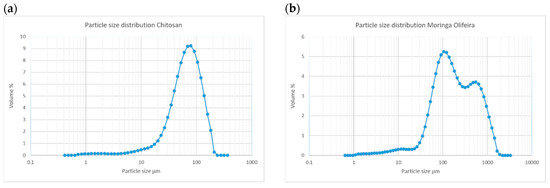
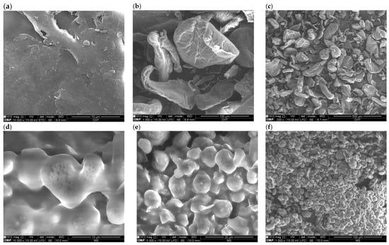
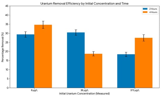
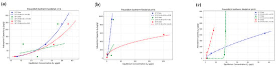
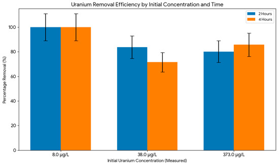
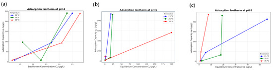
This study evaluated the baseline performance of unmodified Moringa oleifera seeds and crustacean-derived chitosan for uranium removal from aqueous solutions relevant to naturally occurring radioactive material (NORM) contamination. Batch adsorption experiments were conducted using uranium-spiked solutions with nominal concentrations of 10, 50, and 500 µg/L (measured baseline concentrations of 8, 38, and 484 μg/L). A Taguchi L27 fractional factorial design was applied to optimize uranium biosorption parameters for M. oleifera seeds, while chitosan was assessed through baseline comparative batch trials. All batch experiments, including biosorbent-free controls, were conducted in triplicate to evaluate their reproducibility. Chitosan exhibited limited uranium removal, with a maximum of 34.68% at 8 μg/L. It also formed viscous suspensions that hindered filtration. In contrast, M. oleifera seeds demonstrated superior adsorption performance, achieving a maximum removal efficiency of 99.32% and a maximum adsorption capacity of 0.93 mg/g (932 µg/g). Analysis of means (ANOM) and analysis of variance (ANOVA) identified initial pH and initial uranium concentration as the co-dominant factors governing removal efficiency. The highest removal efficiency was obtained at 484 µg/L, pH 4, 25 °C, 2.0 g/L adsorbent dosage, and 90 min contact time. Adsorption isotherm modeling derived from dedicated equilibrium trials showed strong agreement with the Freundlich model (R2 > 0.95), consistent with sorption onto energetically heterogeneous surface sites. Overall, unmodified M. oleifera seeds show high baseline efficacy for dilute uranium removal. However, the optimum conditions identified here are more acidic than the near-neutral pH of most NORM-impacted waters; thus, practical implementation must also account for competing carbonate speciation.
Full article
(This article belongs to the Section Water Quality and Contamination)
►▼
Show Figures

Figure 1
Open AccessArticle
Event-Aware Validation of Short-Term Water-Level Forecasting in a Single Data-Scarce Gauged Catchment: Implications for Local Flash-Flood Risk Management
by
Xubin He, Xinyan Jing, Zhonglin Yang, Zhiming Yan, Mengyuan You, Yizhou Yang, Rudong Huang, Weiwei Yu, Qinke Sun, Xinsong Chen and Jiayi Fang
Water 2026, 18(19), 2424; https://doi.org/10.3390/w18192424 - 29 Sep 2026
Abstract
Overlapping forecasting windows can conceal the limited independence of event archives. We evaluated seven models using 2039 records from 41 events at Hongjiata Hydrological Station during 2016–2025. Telemetry elevations were harmonized by adding 0.665 m before 2023. Forecasts at 1, 3, 6, and
[...] Read more.
Overlapping forecasting windows can conceal the limited independence of event archives. We evaluated seven models using 2039 records from 41 events at Hongjiata Hydrological Station during 2016–2025. Telemetry elevations were harmonized by adding 0.665 m before 2023. Forecasts at 1, 3, 6, and 12 h used 12 or 24 h inputs. Primary validation trained on 2016–2023, validated on 2024, and tested on seven 2025 events. Five neural seeds, event-level evaluation, repeated event-disjoint partitions, and temporal and sample-support sensitivities assessed robustness. With 12 h inputs, Ridge achieved 1 h root mean square error (RMSE) of 0.107 m and Nash–Sutcliffe efficiency (NSE) of 0.908; convolutional neural network–long short-term memory (CNN-LSTM) achieved RMSE of 0.119 ± 0.012 m. The best mean-ranked 6 and 12 h configurations retained negative NSE. On matched 1 h targets from six events, CNN-LSTM strict-minus-random event-mean RMSE was 0.023 m (exploratory 95% bootstrap interval: 0.003–0.047 m). This difference varied across configurations. No 2025 observations exceeded the 31.50 m blue threshold. The results support event-aware assessment of local water-level forecasting without establishing cross-catchment generalization or warning-detection skill.
Full article
(This article belongs to the Section Hydrology)
Open AccessArticle
Spatially Differentiated Assessment of River Health in an Arid Seasonal Basin: A Case Study of the Yarkant River
by
Yifan Su, Liansheng Li, Yipeng Liao and Lin Gan
Water 2026, 18(19), 2423; https://doi.org/10.3390/w18192423 - 29 Sep 2026
Abstract
River health assessment in arid seasonal rivers is challenging because strong hydrological seasonality, spatial heterogeneity, and intensive human intervention can produce substantial differences among river reaches. Conventional basin-scale assessments may obscure localized ecological and management problems when indicators with different spatial characteristics are
[...] Read more.
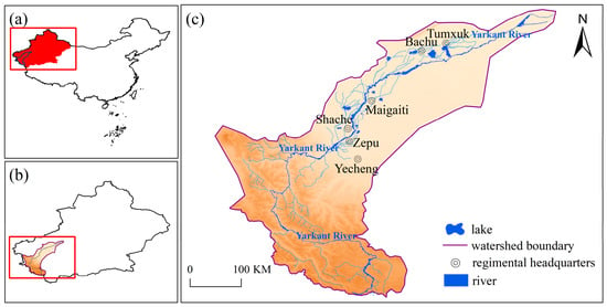
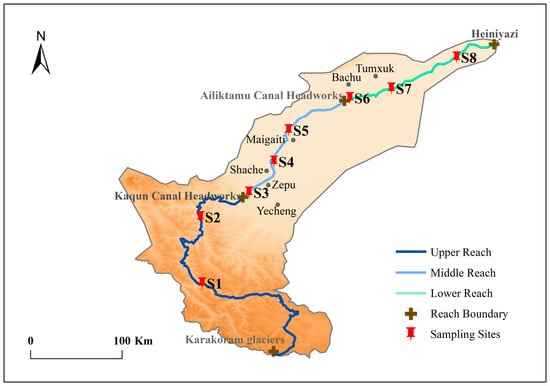
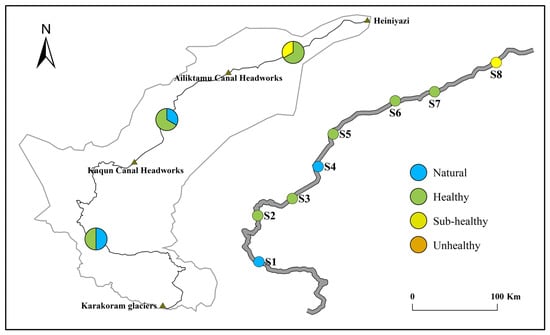
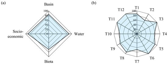
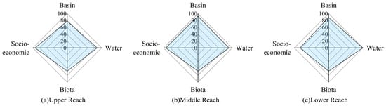
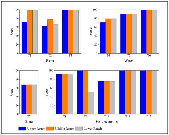
River health assessment in arid seasonal rivers is challenging because strong hydrological seasonality, spatial heterogeneity, and intensive human intervention can produce substantial differences among river reaches. Conventional basin-scale assessments may obscure localized ecological and management problems when indicators with different spatial characteristics are evaluated using a uniform spatial unit. This study developed a spatially differentiated river health assessment approach for the Yarkant River Basin, an arid seasonal river basin in northwestern China. River health was considered an integrated condition encompassing basin structure, water conditions, aquatic biota, and socio-economic service functions. A multi-dimensional indicator system comprising 12 indicators across four criteria was established. The main methodological feature is that indicators were evaluated using spatial units consistent with their physical meanings, monitoring characteristics, and available data. Reach-based indicators were calculated separately for the upper, middle, and lower reaches, whereas ecological-flow and water-quality-related indicators were evaluated using hydrological control sections and water function zones, respectively, and then linked to the corresponding reaches for aggregation. Fish retention, public satisfaction, water supply reliability, and drinking-water-source compliance were also calculated separately for the three reaches using reach-specific data. A composite weighting method integrating a guideline-based least-squares weighting component and an entropy-based objective weighting component was used to aggregate the indicator scores. The Yarkant River obtained an overall River Health Index (RHI) of 84.24, corresponding to the “healthy” category under the adopted classification scheme. The upper, middle, and lower reaches scored 83.23, 87.03, and 83.32, respectively. However, the Biota criterion scored only 68.00, substantially lower than the Water (88.47) and Socio-economic service (90.41) criteria. This contrast indicates that the composite RHI should not be interpreted as evidence of uniformly good ecological integrity, particularly because the biological assessment is represented by a single fish-based indicator. The results highlight the value of retaining indicator-specific spatial information and interpreting the composite RHI together with its individual ecological and functional dimensions.
Full article
(This article belongs to the Special Issue Intelligent Regulation and Adaptive Management of Complex River Basin Systems)
►▼
Show Figures

Figure 1
Open AccessArticle
Contrasting Hydrodynamic Behavior and Climate Sensitivity of Two Karst Springs in the Aggtelek Karst (NE Hungary): Evidence for System-Dependent Climate Responses
by
Márta Czuppon-Lázár, Attila Kovács, Ákos Boros, Lóránt Biró and György Czuppon
Water 2026, 18(19), 2422; https://doi.org/10.3390/w18192422 - 29 Sep 2026
Abstract
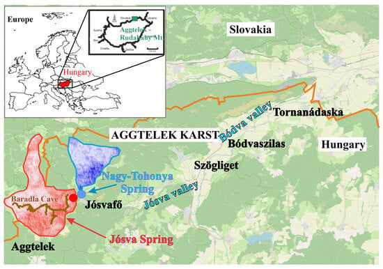
Karst spring discharge is highly sensitive to climatic variability, but responses may differ markedly even within the same karst region. We compared long-term discharge dynamics and potential future changes of the Nagy-Tohonya and Jósva springs in the Aggtelek Karst (NE Hungary) using statistical
[...] Read more.
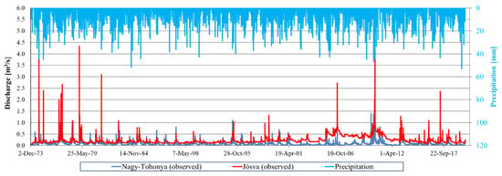
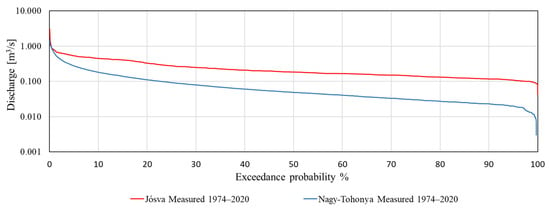
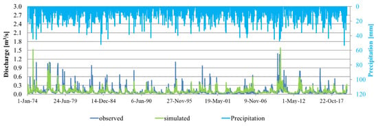
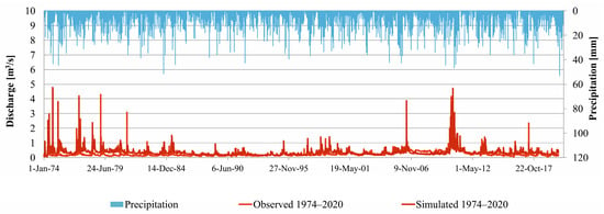
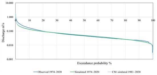
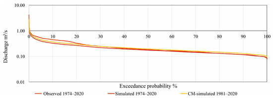
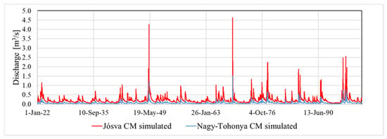
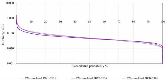
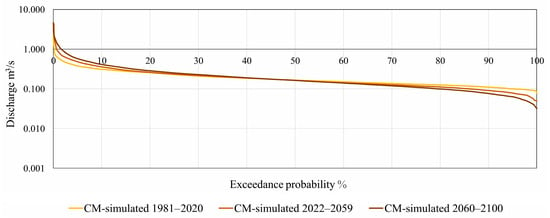
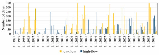
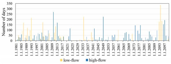
Karst spring discharge is highly sensitive to climatic variability, but responses may differ markedly even within the same karst region. We compared long-term discharge dynamics and potential future changes of the Nagy-Tohonya and Jósva springs in the Aggtelek Karst (NE Hungary) using statistical analysis, flow duration curves, recession coefficients, periodicity analysis, and hydrological modelling driven by climate projections. The two springs exhibit contrasting hydrological behavior: Nagy-Tohonya shows high discharge variability and rapid responses to recharge, whereas Jósva exhibits a more buffered discharge regime with lower relative variability and more sustained low flows. Future simulations project decreasing mean discharge for both springs during 2022–2059, followed by contrasting late-century responses. Nagy-Tohonya remains highly variable but shows comparatively limited changes in its overall discharge distribution, whereas Jósva exhibits a widening discharge range, with increasing high flows and declining low flows. Model evaluation indicates that simulated discharge variability is generally damped, requiring caution when interpreting projected extremes. These results demonstrate that climatechange impacts cannot be generalized across geographically close karst systems and emphasize the need for system-specific assessment, climate adaptation, and water management strategies addressing both future water availability and hydrological extremes.
Full article
(This article belongs to the Special Issue Climate Change Adaptation and Water Governance)
►▼
Show Figures

Figure 1
Open AccessArticle
Chemical Mass Fluxes and Water Quality Assessment of the Transboundary Shu River, Central Asia
by
Ainur Musakulkyzy, Azamat Madibekov, Christian Opp, Laura Ismukhanova, Askhat Zhadi, Aray Sultanayeva and Yergen Maksim
Water 2026, 18(19), 2421; https://doi.org/10.3390/w18192421 - 29 Sep 2026
Abstract
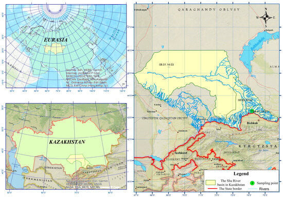
This study presents long-term background concentration estimates for hydrochemical parameters in the Shu River at the Kaynar transboundary section for 2002–2025 and assesses chemical mass transport across this section. Annual mean values for 31 hydrochemical parameters were analyzed; 533 annual values were processed,
[...] Read more.
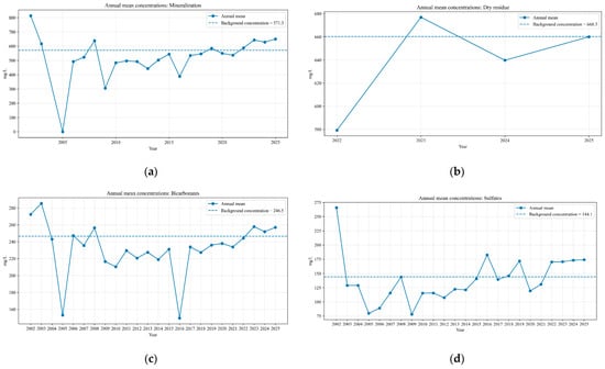
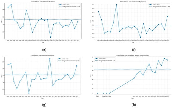
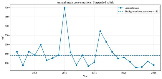
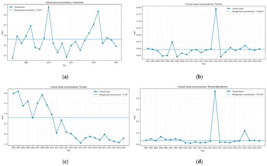
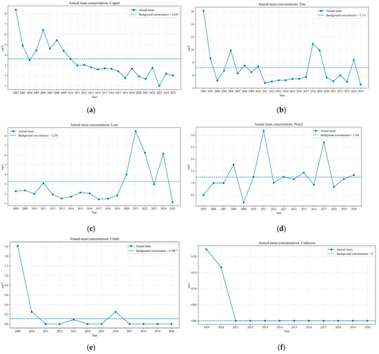
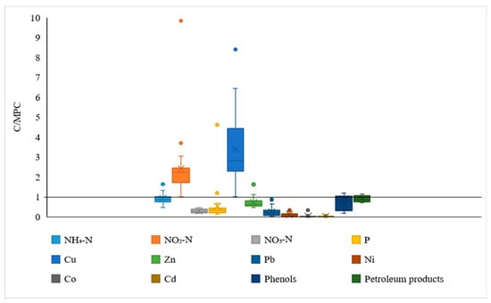
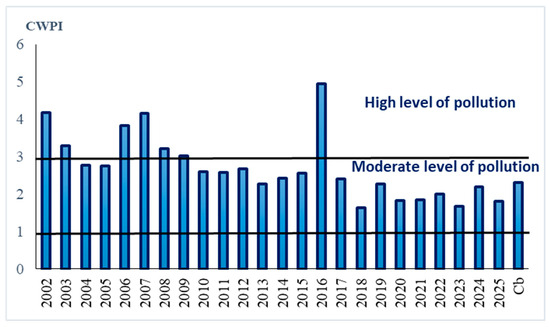
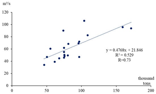
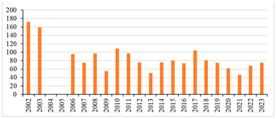
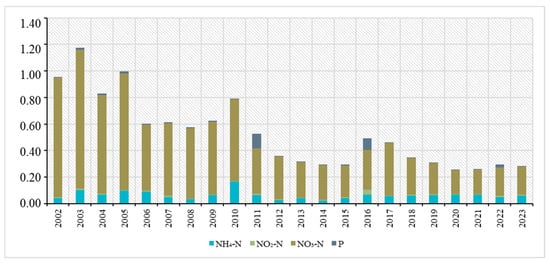
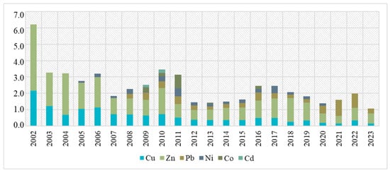
This study presents long-term background concentration estimates for hydrochemical parameters in the Shu River at the Kaynar transboundary section for 2002–2025 and assesses chemical mass transport across this section. Annual mean values for 31 hydrochemical parameters were analyzed; 533 annual values were processed, and 498 remained after statistical extremes were excluded from background-concentration calculations. Background concentrations were estimated as one-sided confidence limits of the mean at a 0.95 confidence level. The Shu River water is characterized by a bicarbonate-sulfate composition and moderately elevated mineralization. Background-level exceedances of the reference maximum permissible concentration (MPC) values were observed for sulfate, nitrite nitrogen (NO2-N), and copper. Suspended solids were assessed separately because the applicable criterion is expressed relative to the background concentration rather than as a fixed MPC value. The comprehensive water pollution index (CWPI) indicated moderate pollution in most years, with high pollution levels in 2002, 2003, 2006–2008, and 2016. Annual mass transport of ionic constituents increased from 555.2 thousand metric tons in 2021 to 899.6 thousand metric tons in 2023, while nutrient mass transport ranged from 3.14 to 3.55 thousand metric tons per year. Nitrate nitrogen (NO3-N) made the largest contribution to nutrient mass transport. The results support regional water-quality assessment and water-protection planning in arid transboundary river basins.
Full article
(This article belongs to the Section Water Quality and Contamination)
►▼
Show Figures

Figure 1
Open AccessArticle
Divergent Controls on Sustained Increases and Decreases in Global Water Use Efficiency over the Past Four Decades
by
Yan Li, Zhanlin Ma, Guangchao Li and Zhen Yang
Water 2026, 18(19), 2420; https://doi.org/10.3390/w18192420 - 29 Sep 2026
Abstract
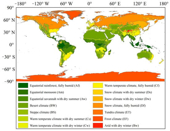
Global water use efficiency (WUE) is a key indicator characterizing the carbon–water coupling relationship in terrestrial ecosystems. Elucidating its spatiotemporal evolution characteristics and driving mechanisms is of great significance for evaluating ecosystem carbon sink functions and formulating water resource management strategies under global
[...] Read more.
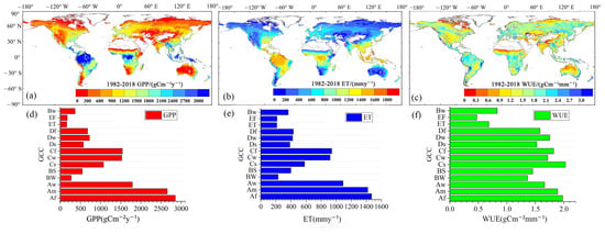
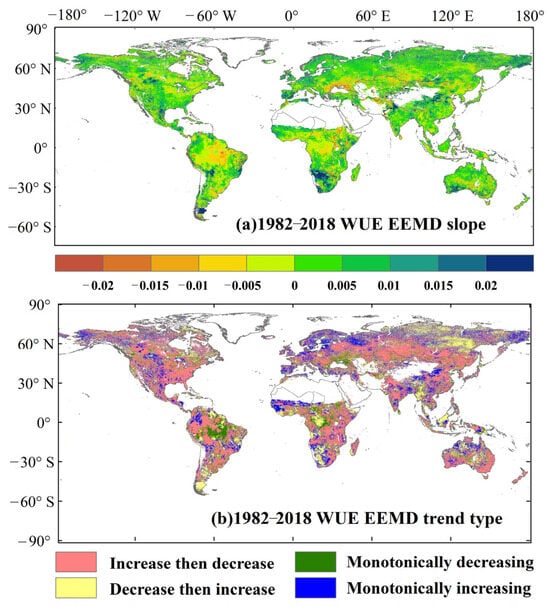
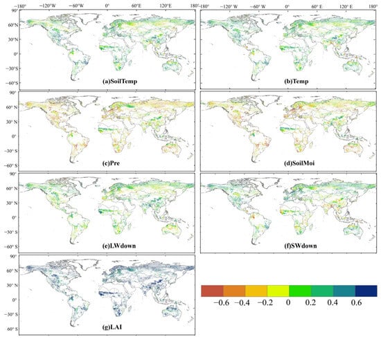
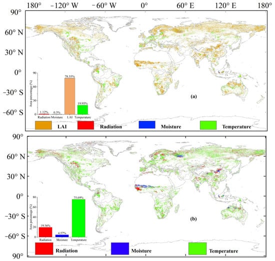
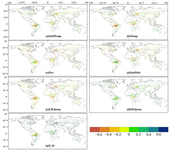
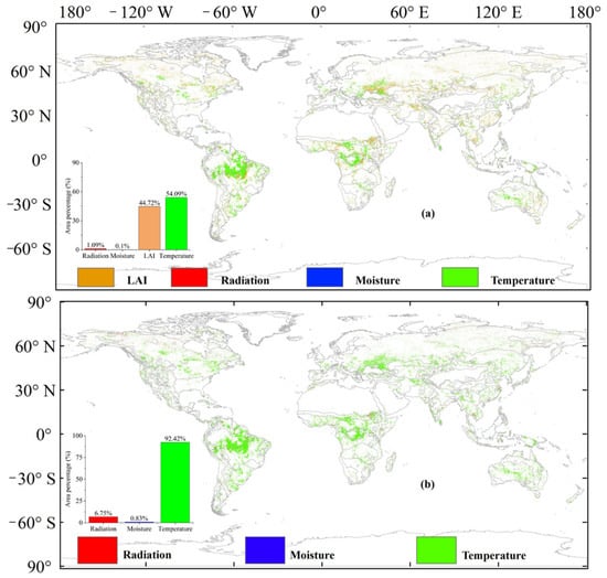
Global water use efficiency (WUE) is a key indicator characterizing the carbon–water coupling relationship in terrestrial ecosystems. Elucidating its spatiotemporal evolution characteristics and driving mechanisms is of great significance for evaluating ecosystem carbon sink functions and formulating water resource management strategies under global change. Based on multi-source datasets integrating satellite remote sensing products and land surface model-derived evapotranspiration (ET) from 1982 to 2018, this study systematically analyzed the spatiotemporal evolution patterns of global WUE and identified the strongest statistical association factors and their spatial distributions, clarifying the key driving factors and spatial distribution characteristics of sustained increases and decreases in global WUE. The results were as follows: (1) From 1982 to 2018, WUE showed an increasing trend in approximately 62.24% of vegetated areas globally, with a significant increase in area accounting for 14.95% (slope ≥ 0.01). By trend type, monotonically increasing and monotonically decreasing areas accounted for 20.96% and 9.36% of global vegetated areas, respectively. (2) Under the combined influence of biotic and climatic factors, leaf area index (LAI) had the strongest correlation with areas of sustained WUE increase, covering the highest proportion (78.55%). When considering only climatic factors, temperature exerted the most significant influence on sustained WUE increase, covering an area of approximately 75.69%. (3) For areas of sustained WUE decrease, climatic factors exhibited the strongest correlation under the combined effects of biotic and climatic factors, accounting for approximately 55.28%, among which temperature contributed the most (approximately 54.09%). When considering only climatic factors, the impact of temperature on sustained WUE decrease rose to 92.42%. This study deepens the understanding of global vegetation carbon–water coupling mechanisms and provides a key scientific basis for identifying regionalized water resource management strategies that enhance ecosystem carbon sink capacity under climate change.
Full article
(This article belongs to the Section Water Resources Management, Policy and Governance)
►▼
Show Figures

Figure 1
Open AccessArticle
DH-YOLO: An Improved Method for Waterway Revetment Damage Detection
by
Jian Wan, Huayu Liu, Jinfeng Ding, Kai Huang, Yinfei Xi, Yutong Zhu, Yamin Huang and Changshi Xiao
Water 2026, 18(19), 2419; https://doi.org/10.3390/w18192419 - 29 Sep 2026
Abstract
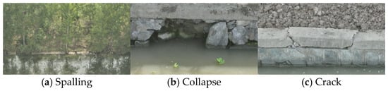
As a key component of inland waterway infrastructure, the structural integrity of waterway revetments is directly related to navigation safety and aquatic ecological stability. However, in complex inland water environments, the process of damage detection and hazard prevention is confronted with numerous challenges.
[...] Read more.
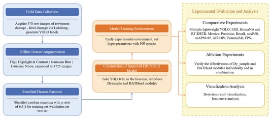
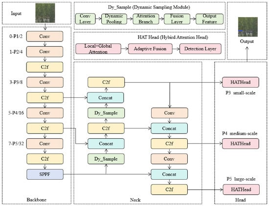
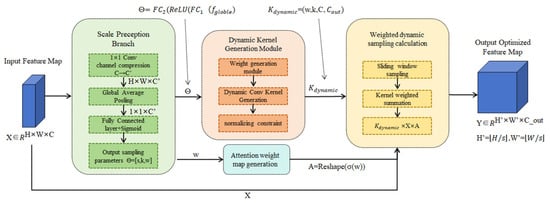
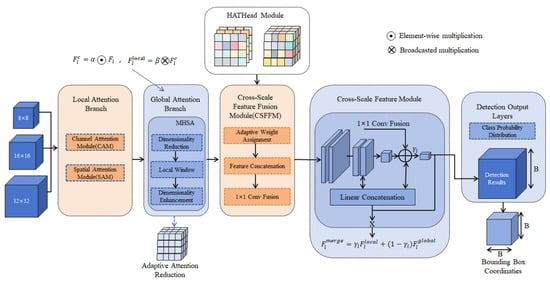
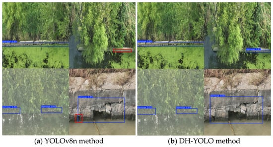
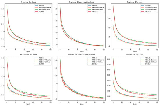
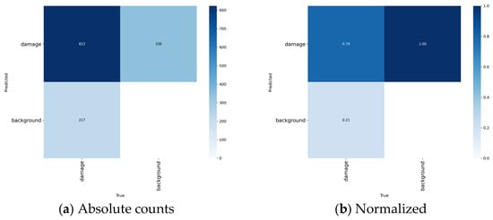
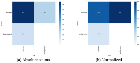
As a key component of inland waterway infrastructure, the structural integrity of waterway revetments is directly related to navigation safety and aquatic ecological stability. However, in complex inland water environments, the process of damage detection and hazard prevention is confronted with numerous challenges. These include intense background interference, a high missed detection rate for small-scale damage, and insufficient real-time performance. To address the aforementioned issues, this paper proposes DH-YOLO, a lightweight architecture for damage detection. Building upon the efficient YOLOv8n backbone, the proposed model enhances feature sampling and discriminability capabilities through the task-specific integration of the Dynamic Upsampler (Dy_Sample) and the Hybrid Attention Transformer Head (HATHead) modules. This study emphasizes the detection of damage presence, rather than its classification or recognition. Evaluated on a custom-built image dataset of revetment damage, the proposed method achieves a Precision of 81.5%, Recall of 76.9%, mAP50 of 81.7%, and mAP50–95 of 48.6%, while maintaining a low computational cost of 6.9 GFLOPs. These results indicate that compared with mainstream models, the proposed algorithm achieves a favorable overall trade-off between accuracy and efficiency, and exhibits application potential for real-time damage detection and hazard prevention in complex inland waterway environments.
Full article
(This article belongs to the Section New Sensors, New Technologies and Machine Learning in Water Sciences)
►▼
Show Figures

Figure 1
Open AccessReview
Electrochemical Phosphorus Recovery as a Continuum: Integrating Electro-Oxidation, Electrodissolution, and Interfacial Crystallization
by
Jui-Shuan Yu, Vinh Ya and Naresh Mameda
Water 2026, 18(19), 2418; https://doi.org/10.3390/w18192418 - 29 Sep 2026
Abstract
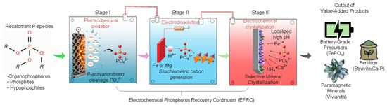
Electrochemical phosphorus recovery (EPR) provides a sustainable alternative to conventional chemical precipitation by generating in situ alkalinity, oxidants, and coagulating cations, thereby minimizing chemical reagent dosing. However, practical implementation remains constrained because electrochemical oxidation (EO), electrodissolution (ED), and electrochemical crystallization are predominantly investigated
[...] Read more.
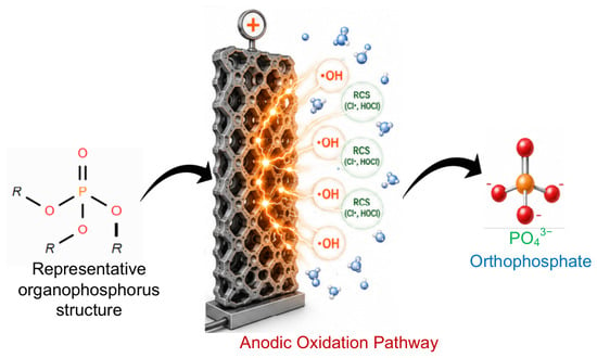
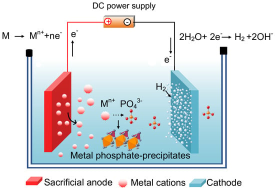
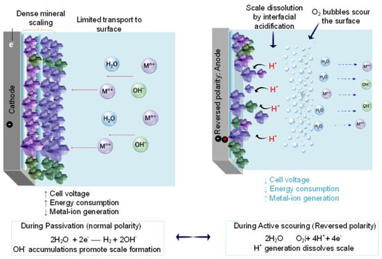
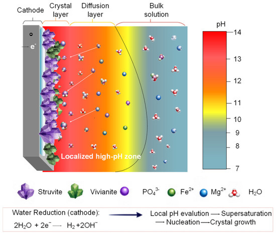
Electrochemical phosphorus recovery (EPR) provides a sustainable alternative to conventional chemical precipitation by generating in situ alkalinity, oxidants, and coagulating cations, thereby minimizing chemical reagent dosing. However, practical implementation remains constrained because electrochemical oxidation (EO), electrodissolution (ED), and electrochemical crystallization are predominantly investigated as separate unit processes, obscuring their synergistic mechanisms. Here, we introduce the Electrochemical Phosphorus Recovery Continuum (EPRC), an integrated mechanistic framework that combines non-orthophosphate activation, Faradaic cation dosing, and interfacial crystallization into a continuous, value-oriented recovery pathway. We systematically review the charge-transfer kinetics, electrode materials, and reactor hydrodynamic architectures governing each stage, while assessing key technical and economic barriers, including specific energy consumption, sacrificial-anode passivation, and matrix-induced competitive-ion effects. Building on this synthesis, we propose an engineering roadmap for scalable, intelligent EPR platforms that convert complex waste streams into customized agricultural fertilizers and high-value phosphate precursors, including FePO4 for potential LiFePO4 synthesis.
Full article
(This article belongs to the Special Issue Wastewater Treatment to Resource Recovery: Emerging Technologies for Circular and Sustainable Water Systems)
►▼
Show Figures

Figure 1
Open AccessArticle
Performance and Stability of an Aerobic Mesophilic Trickling Filter for Treatment of Process Water from Hydrothermal Carbonization of Sewage Sludge
by
Tommy Ender, Vicky Shettigondahalli Ekanthalu, Ralf Schefler, Elisa Uta Deiß, Bernd Kreikemeyer, Israel Barrantes, Cinthya Lara Verdezoto and Michael Nelles
Water 2026, 18(19), 2417; https://doi.org/10.3390/w18192417 - 29 Sep 2026
Abstract
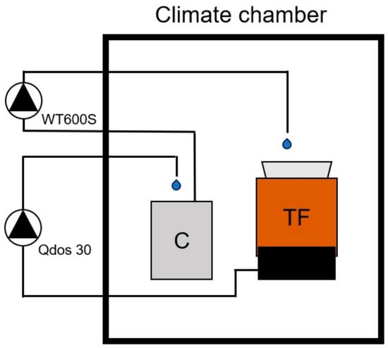
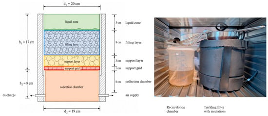
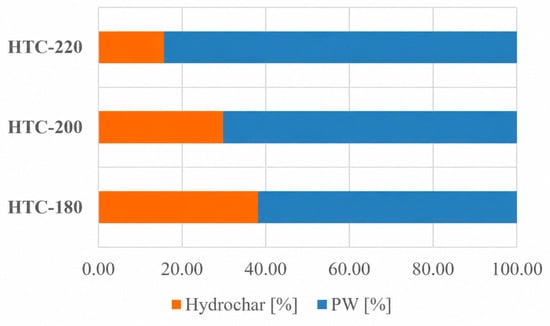
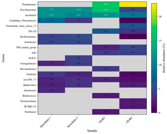
Hydrothermal carbonization (HTC) converts wet biomass such as sewage sludge (SS) into hydrochar and also produces highly contaminated process water (PW) that requires further treatment. This study evaluated the aerobic biological treatment of diluted PW in a laboratory-scale mesophilic trickling filter operated in
[...] Read more.
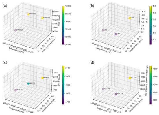
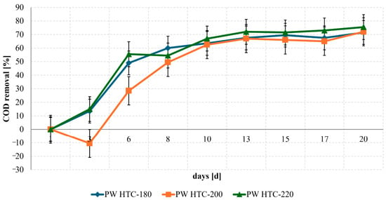
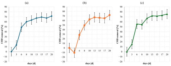
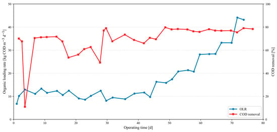
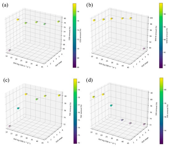
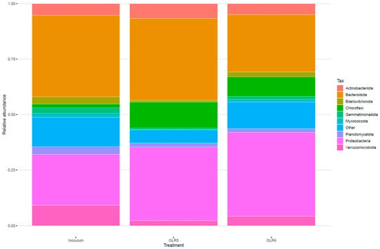
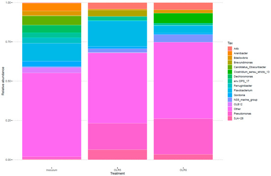
Hydrothermal carbonization (HTC) converts wet biomass such as sewage sludge (SS) into hydrochar and also produces highly contaminated process water (PW) that requires further treatment. This study evaluated the aerobic biological treatment of diluted PW in a laboratory-scale mesophilic trickling filter operated in repeated-batch mode with intermittent recirculation under sequentially increasing organic loading conditions. SS was hydrothermally carbonized at 180, 200, and 220 °C for 1 h. The resulting PW samples were chemically characterized and assessed for aerobic biodegradability. PW generated at 220 °C was selected for treatment in the trickling filter. After reactor start-up and biofilm adaptation, the main 75-day experiment was conducted at 30 °C, with the recirculation-based organic loading rate (OLR) increased sequentially in six stages. TOC removal averaged 78.00 ± 3.39%, while VFA removal averaged 76.42 ± 4.47%. NH4-N removal averaged 97.95 ± 4.14% during the first five loading stages but decreased to 89.53% at the highest OLR. Under the investigated conditions, approximately 30–33 kg COD m−3 d−1 represented the highest recirculation-based loading range at which carbon, VFA, and NH4-N removal remained jointly stable. Qualitative GC-MS screening indicated transformation or removal of part of the detectable organic fraction, while 16S rRNA gene amplicon sequencing showed changes in microbial community composition during high-load operation. Overall, the laboratory-scale trickling filter effectively treated diluted SS-derived HTC-PW. However, substantial PW dilution, the repeated-batch operating mode, and residual poorly biodegradable organics limit direct extrapolation to full-scale treatment of raw PW.
Full article
(This article belongs to the Special Issue Research on Biological Wastewater Treatment and Reuse)
►▼
Show Figures

Figure 1
Open AccessArticle
Post-Regulation Hydrological and Channel-Planform Changes in the Urban Reach of the Lhasa River
by
Tongliang Gong, Zhaocai Yi, Danzeng Baima and Hanwen Liu
Water 2026, 18(19), 2416; https://doi.org/10.3390/w18192416 - 29 Sep 2026
Abstract
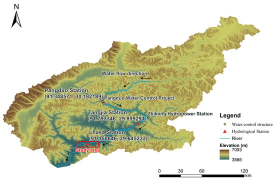
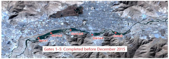
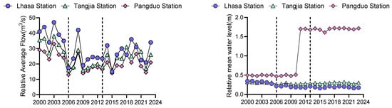
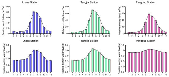
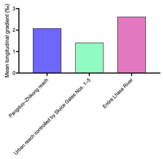
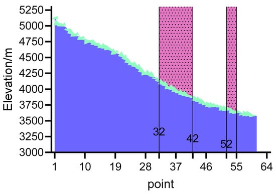
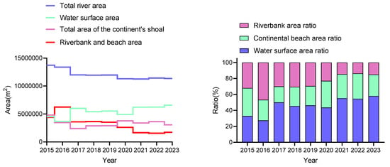
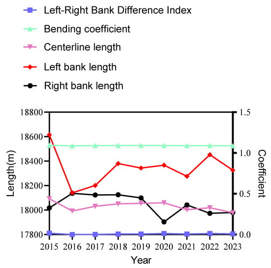
Hydrological regulation and local engineering can modify the planform dynamics of wandering rivers, but separating their effects is difficult where pre-regulation morphology and synchronous hydraulic observations are unavailable. This study integrates discharge and water-level records (2000–2023), SRTM-derived surface topography, and nine December satellite-image
[...] Read more.
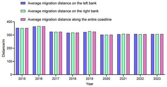
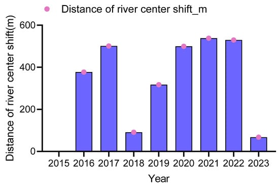
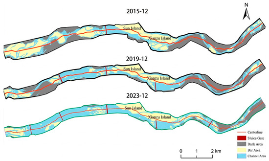
Hydrological regulation and local engineering can modify the planform dynamics of wandering rivers, but separating their effects is difficult where pre-regulation morphology and synchronous hydraulic observations are unavailable. This study integrates discharge and water-level records (2000–2023), SRTM-derived surface topography, and nine December satellite-image composites (2015–2023) for the urban Lhasa River reach between Gates 1 and 5. Within the available 24-year discharge record, Pettitt tests identify a mid-2000s distributional shift at the three stations; sensitivity tests place the detected change in 2005–2006. Because the pre-change segment contains only six years and no precipitation-based natural-flow control was available, the result is interpreted as temporally consistent with, but not proof of an effect of, Zhikong Hydropower Station commissioning. The 2013 Pangduo project is treated separately as an engineering timeline marker because no distinct annual mean breakpoint was detected at that date. Mapped water area increased by 45.39% between 2015 and 2023, whereas exposed bar–island and riparian-land classes decreased by 36.29% and 61.13%, respectively. These values are reported as a water-surface expansion signal consistent with gate impoundment and/or acquisition-stage differences, not as confirmed sedimentary or geomorphic conversion. The comparison also contains sensor-dependent positional uncertainty: approximately ±15 m for the 2015 and 2018 Landsat-8 inputs and ±5 m for Sentinel-2 inputs. Centerline length and sinuosity varied by less than 1%. The nearest-neighbor bankline metric declined by 9.53%, whereas the node-mean channel-regime-center metric declined by 81.99%; the latter is retained only as an exploratory indicator because it is sensitive to centerline-node sampling. Overall, the observations are consistent with reduced lateral activity in an engineered reach, but the available evidence does not isolate reservoir regulation, gate operation, bank protection, climate, land use, or sediment-supply effects. Stronger causal inference requires a pre-regulation morphological baseline, synchronous discharge and water-level observations at image acquisition, fixed-interval centerline resampling, sediment data, and surveyed hydraulic geometry.
Full article
(This article belongs to the Section Hydrology)
►▼
Show Figures

Figure 1
Journal Menu
► ▼ Journal Menu-
- Water Home
- Aims & Scope
- Editorial Board
- Reviewer Board
- Topical Advisory Panel
- Early Career Editorial Board
- Instructions for Authors
- Special Issues
- Topics
- Sections
- Article Processing Charge
- Indexing & Archiving
- Editor’s Choice Articles
- Most Cited & Viewed
- Journal Statistics
- Journal History
- Journal Awards
- Society Collaborations
- Conferences
- Editorial Office
Journal Browser
► ▼ Journal BrowserHighly Accessed Articles
Latest Books
E-Mail Alert
News
Topics
Topic in
Agriculture, Climate, Energies, Land, Water
Energy, Environment and Climate Policy Analysis
Topic Editors: Xiaoqian Song, Jiajie LiDeadline: 30 September 2026
Topic in
Clean Technol., Materials, Molecules, Recycling, Water, Nanomaterials, Catalysts
Advanced Composites for Waste Valorization and Pollutant Degradation
Topic Editors: Iwona Kuzniarska-Biernacka, Ana Sofia MestreDeadline: 31 October 2026
Topic in
Applied Sciences, Hydrology, JMSE, Water, Eng
Hydraulic Engineering and Modelling
Topic Editors: Guohua Zhang, Feng Xiong, Xiaobo ZhangDeadline: 30 November 2026
Topic in
Atmosphere, GeoHazards, Geosciences, Water, Environments
Natural Hazards and Environmental Challenges in the Anthropocene Age, 2nd Edition
Topic Editors: Quoc Bao Pham, Eyyüp Ensar Başakın, Hone-Jay Chu, Ömer EkmekciogluDeadline: 31 December 2026
Conferences
Special Issues
Special Issue in
Water
Multicriteria Analysis and Decision-Making in Water Resources Management
Guest Editor: Michael P. StragerDeadline: 30 September 2026
Special Issue in
Water
GIS Applications in Hydrology and Water Resources
Guest Editor: Daniel P. AmesDeadline: 30 September 2026
Special Issue in
Water
Energy Recovery and Clean Water: Techno-Economic and Environmental Assessments—2nd Edition
Guest Editors: Navneet Kumar, Bernhard TischbeinDeadline: 30 September 2026
Special Issue in
Water
Geothermal Reservoir Modeling: Emerging Techniques, Practical Applications and Modeling Challenges
Guest Editor: Rita Esuru OkoroaforDeadline: 30 September 2026