



-
Estimating the Importance of Floating Surface Material to the Total Phosphorus Transport in Silver Creek, Wisconsin Using Particle Image Velocimetry -
How to Analyze Censored Concentration Data Using Modern Statistical Methods of Survival Analysis: Background and Nonparametric Methods -
From Artificial Structures to Biogenic Habitats: Two-Year Ecological Responses to Eco-Engineered Reefs in a Tourism-Dominated Adriatic Sandy Coast
Journal Description
Water
Water
is a peer-reviewed, open access journal on water science and technology, including the ecology and management of water resources, published semimonthly online by MDPI. Water collaborates with the Stockholm International Water Institute (SIWI). In addition, the American Institute of Hydrology (AIH), Polish Limnological Society (PLS) and Japanese Society of Physical Hydrology (JSPH) are affiliated with Water and their members receive a discount on the article processing charges.
- Open Access— free for readers, with article processing charges (APC) paid by authors or their institutions.
- High Visibility: indexed within Scopus, SCIE (Web of Science), Ei Compendex, GEOBASE, GeoRef, PubAg, AGRIS, CAPlus / SciFinder, Inspec, and other databases.
- Journal Rank: JCR - Q2 (Water Resources) / CiteScore - Q1 (Aquatic Science)
- Rapid Publication: manuscripts are peer-reviewed and a first decision is provided to authors approximately 17.7 days after submission; acceptance to publication is undertaken in 2.8 days (median values for papers published in this journal in the first half of 2026).
- Recognition of Reviewers: Reviewers whose reports are timely and of high quality receive an APC discount voucher for a future publication in an MDPI journal. Become a reviewer.
- Companion journals for Water include: Hydropower and Freshwater.
- Journal Clusters of Water Resources: Water, Journal of Marine Science and Engineering, Hydrology, Resources, Oceans, Limnological Review, Coasts and Hydropower.
Impact Factor:
3.5 (2025);
5-Year Impact Factor:
3.6 (2025)
Latest Articles
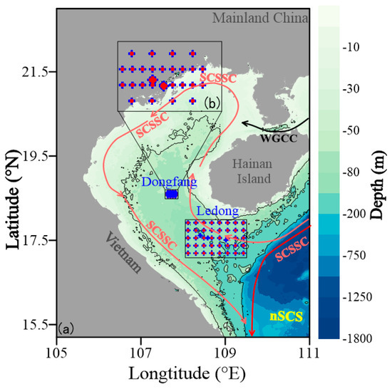
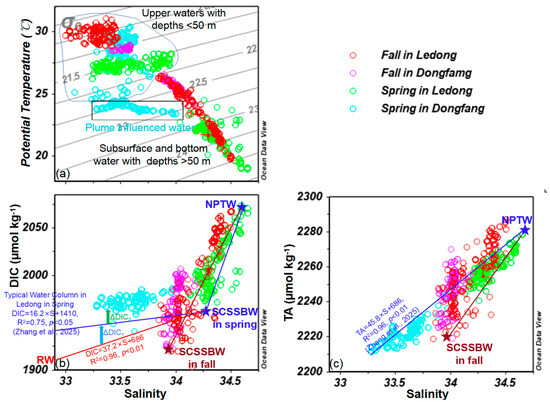
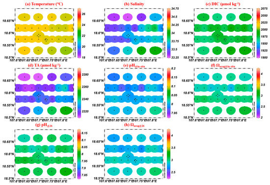
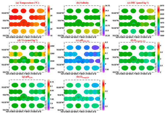
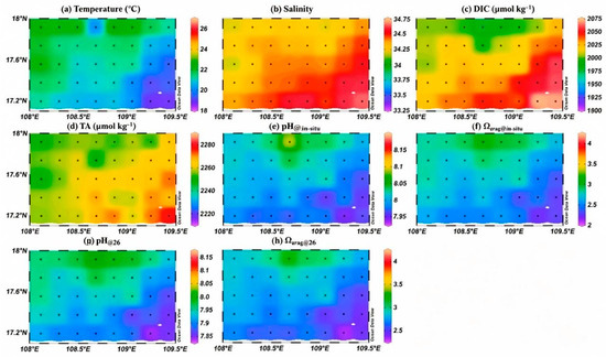
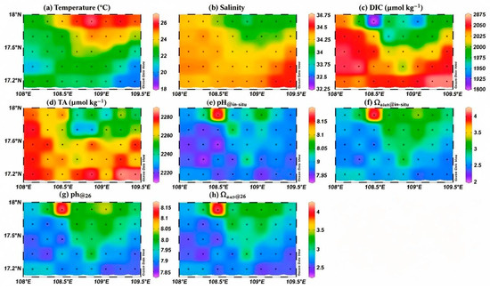
Acidification States and Controlling Factors in Subsurface and Bottom Water of the Beibu Gulf, China
Water 2026, 18(18), 2254; https://doi.org/10.3390/w18182254 (registering DOI) - 10 Sep 2026
Abstract
Previous studies in the Beibu Gulf have documented the distributions and controlling factors of carbonate system parameters in surface waters; however, their dynamics in subsurface and bottom waters remain poorly constrained. Here, we present the first observations of pH and the aragonite saturation
[...] Read more.
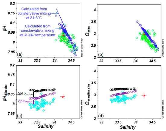
Previous studies in the Beibu Gulf have documented the distributions and controlling factors of carbonate system parameters in surface waters; however, their dynamics in subsurface and bottom waters remain poorly constrained. Here, we present the first observations of pH and the aragonite saturation state (Ωarag) in subsurface and bottom waters of the Beibu Gulf during spring and fall 2024. In spring, pH and Ωarag in subsurface and bottom waters off Ledong were predominantly governed by physical mixing. In contrast, their variability off Dongfang was driven jointly by biological respiration occurring outside the Dongfang oil/gas field and by respiration within the field itself. Quantitative analysis revealed that respiration outside the field increased dissolved inorganic carbon (DIC) concentrations by ~18 ± 3 µmol kg−1, a magnitude comparable to that attributable to in-field respiration (~18 ± 7 µmol kg−1). Collectively, these two respiration sources induced only slightly declines in pH (0.03 ± 0.01 and 0.04 ± 0.01) but statistically significant reductions in Ωarag (0.18 ± 0.03 and 0.21 ± 0.08, respectively). During fall, carbonate system dynamics in subsurface and bottom waters off both Dongfang and Ledong were dominated by physical mixing. The differential influence of North Pacific Tropical Water (NPTW) resulted in a decline in Ωarag from 2.99 ± 0.10 off Dongfang to 2.75 ± 0.32 off Ledong. All observed Ωarag values remained well above the thermodynamic saturation threshold (Ωarag = 1), indicating no immediate risk of ocean acidification to calcifying organisms in the study area under current conditions. This study helps bridge a critical observational gap in the regional inorganic carbonate system. However, due to sampling constraints, carbonate system parameters are reported here for spring and fall only. Observations for summer and winter, as well as multi-year time-series measurements, are planned for the near future.
Full article
(This article belongs to the Special Issue Advances in Biogeochemistry of Estuaries)
►
Show Figures
Open AccessArticle
Contrasting Nitrate Sources and Transport Pathways in a Connected Karst Surface Water and Groundwater System
by
Haowen Liu, Ailin Zhan, Longxinyue Qin, Yuxi Tang, Shuang Liu, Qiang Li, Qinkebuzi Gi, Cuishan Liu and Junliang Jin
Water 2026, 18(18), 2253; https://doi.org/10.3390/w18182253 - 10 Sep 2026
Abstract
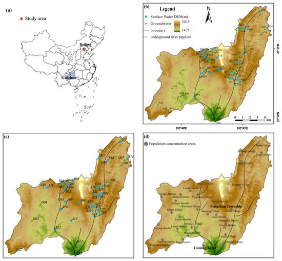
Nitrate contamination threatens surface water and groundwater quality in karst regions, posing risks to drinking water safety and aquatic ecosystems. Strong surface water–groundwater connectivity in karst recharge areas can accelerate contaminant transport through fractures and conduits. In this study, 166 samples, comprising 100
[...] Read more.
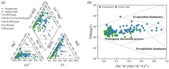
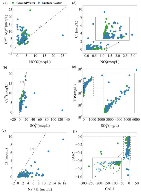
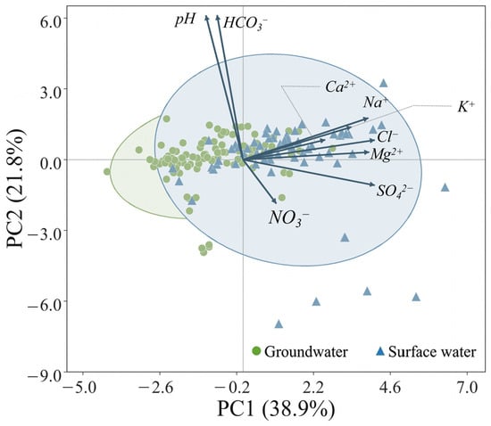
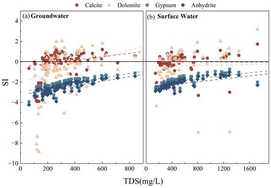
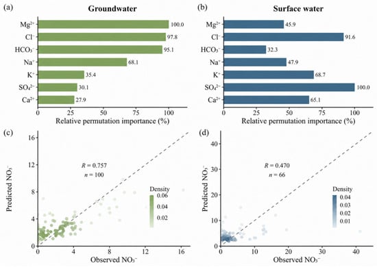
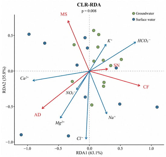
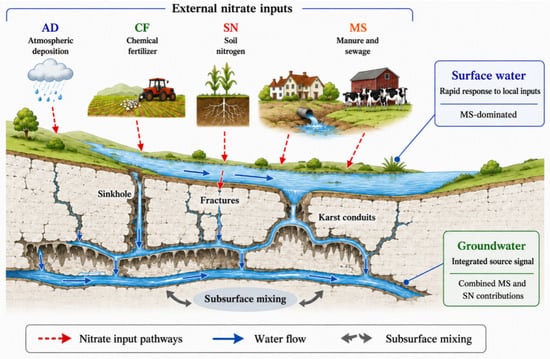
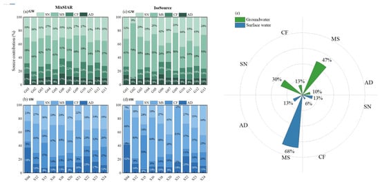
Nitrate contamination threatens surface water and groundwater quality in karst regions, posing risks to drinking water safety and aquatic ecosystems. Strong surface water–groundwater connectivity in karst recharge areas can accelerate contaminant transport through fractures and conduits. In this study, 166 samples, comprising 100 groundwater samples and 66 surface-water samples, were collected under wet-season, normal-flow, and dry-season conditions from a typical karst recharge area in Fengshan Township, Dafang County, Guizhou Province, China. Hydrochemical analyses, dual nitrate isotope analysis, and isotope-based mixing models were integrated to evaluate potential nitrate source contributions and examine the hydrochemical factors associated with nitrate variability. Groundwater was dominated by Ca–HCO3 and mixed hydrochemical facies and exhibited relatively stable ionic compositions, whereas surface water showed more diverse facies and greater variability in total dissolved solids, SO42−, Na+, K+, and Cl−, reflecting a stronger response to external inputs and short-term hydrological processes. NO3− concentrations ranged from 0.02 to 16.24 mg/L in groundwater and from 0.00 to 41.20 mg/L in surface water, with mean concentrations of 3.07 and 4.38 mg/L, respectively. Mixing-model estimates identified manure and sewage (47%) and soil nitrogen (30%) as the leading potential contributors to groundwater nitrate, whereas manure and sewage had the largest estimated contribution to surface-water nitrate (68%). Given the overlap among the isotopic signatures of potential sources, these percentages represent probable source combinations rather than exact apportionments. The absence of consistent covariation between NO3− and Cl− indicated that nitrate transport was not controlled solely by conservative mixing but was jointly regulated by source-input intensity, rapid surface-runoff responses, conduit transport, subsurface mixing, dilution, and water–rock interactions. Statistical modeling further showed that groundwater NO3− variability was associated with the major-ion composition, whereas surface-water NO3− variability was partly explained by a multiple regression model incorporating SO42− and Cl−. Together, these findings support a conceptual source-to-transport framework involving external inputs, rapid surface-water responses, karst conduit transport, subsurface mixing, and water–rock interaction. This study provides insight into contrasting potential nitrate sources and transport processes in connected karst surface water-groundwater systems and supports pollution-source tracing, recharge-area management, and drinking-water source protection.
Full article
(This article belongs to the Section Hydrogeology)
►▼
Show Figures

Figure 1
Open AccessReview
River Waste Detection Methods for Urban Canals in Southeast Asia—A Review of Present Techniques and Future Perspectives
by
Maiyatat Nunkhaw, Detchphol Chitwatkulsiri and Hitoshi Miyamoto
Water 2026, 18(18), 2252; https://doi.org/10.3390/w18182252 - 10 Sep 2026
Abstract
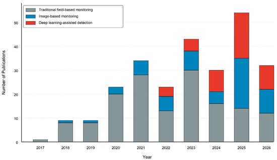
Floating plastic debris in urban canals is a management-relevant precursor to downstream microplastic pollution. This structured narrative review synthesizes conventional field surveys, camera-, UAV-, and satellite-based image analysis and AI-assisted image-based monitoring. Emphasis is placed on Southeast Asian engineered canals, where monsoon-driven flow,
[...] Read more.
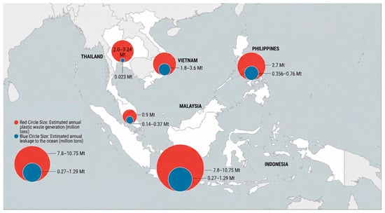
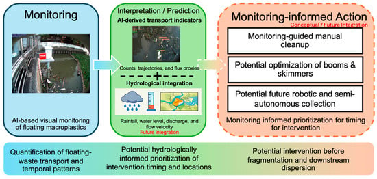
Floating plastic debris in urban canals is a management-relevant precursor to downstream microplastic pollution. This structured narrative review synthesizes conventional field surveys, camera-, UAV-, and satellite-based image analysis and AI-assisted image-based monitoring. Emphasis is placed on Southeast Asian engineered canals, where monsoon-driven flow, tides, gates, turbidity, glare, occlusion, and organic debris challenge continuous observation. Conventional surveys provide verifiable composition data but limited temporal coverage. Camera systems increase observation frequency, while deep learning can automate detection and tracking; however, reported performance depends strongly on the dataset, site, target size, and validation design. Published studies show substantial losses under cross-site transfer and condition-specific gains from preprocessing rather than a universal accuracy threshold. The synthesis therefore develops a decision-oriented framework linking camera calibration, conditional preprocessing, site-separated validation, uncertainty reporting, and hydrological data to operational triggers for cleanup or interception. Current evidence supports monitoring and pilot decision support, while broader autonomous operation requires further field validation. Priorities include transparent evidence reporting, shared Southeast Asian datasets, standardized metrics and environmental descriptors, cross-site testing, and life-cycle evaluation of deployment cost and maintenance.
Full article
(This article belongs to the Special Issue Marine Plastic Pollution: Recent Advances and Future Challenges)
►▼
Show Figures

Figure 1
Open AccessArticle
In Situ Identification of Primary Groundwater Seepage and Transport Pathways in Fracture Networks in Karst Regions Using Self-Potential Probability Tomography
by
Chengliang Du, Lili Jin, Haibin Liu and Yixiang Chen
Water 2026, 18(18), 2251; https://doi.org/10.3390/w18182251 - 10 Sep 2026
Abstract
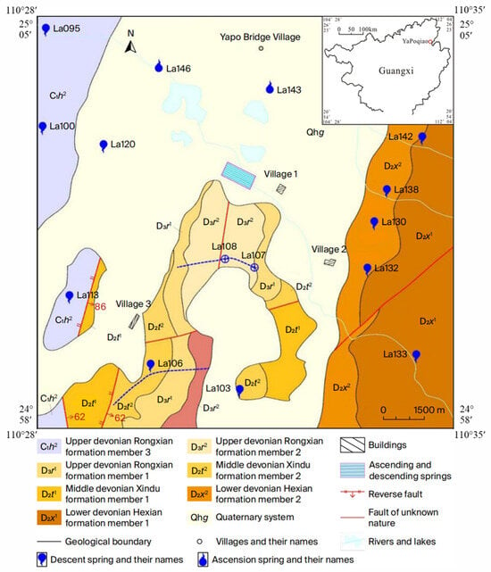
Karst aquifers supply drinking water for about a quarter of the global population. Despite their often shallow occurrence, delineating these aquifers remains challenging due to the fine-scale nature of conduits and pore spaces in the shallow karst zone, compounded by highly complex spatial
[...] Read more.
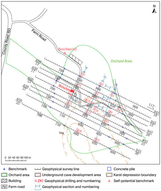
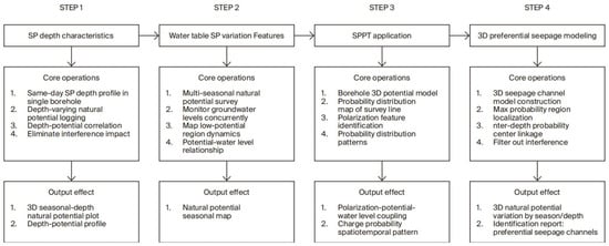
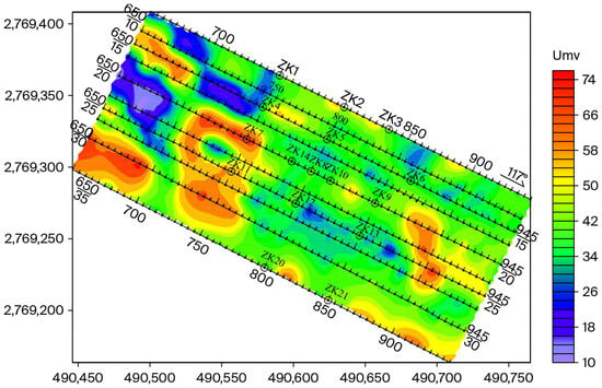
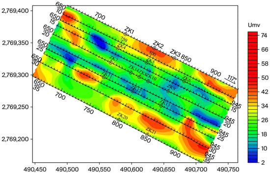
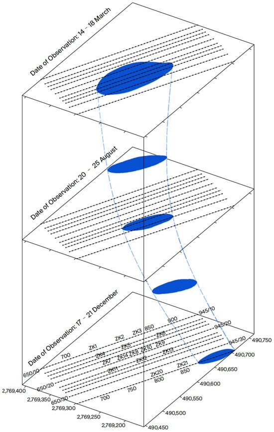
Karst aquifers supply drinking water for about a quarter of the global population. Despite their often shallow occurrence, delineating these aquifers remains challenging due to the fine-scale nature of conduits and pore spaces in the shallow karst zone, compounded by highly complex spatial distributions. This study integrates self-potential probability tomography (SPPT) with electrical resistivity tomography (ERT) and borehole data to identify and characterize preferential flow paths within a heterogeneous karst aquifer in Guangxi, China. Seasonal surface and borehole self-potential datasets acquired in March, August, and December effectively captured the spatiotemporal hydrological dynamics. Results indicate that as the groundwater level drops from 13.7 m to 25.5 m, low-potential anomaly zones and the maximum charge occurrence probability (COP) shift toward the center of the depression. Concurrently, self-potential intensity increases with depth, particularly within areas of well-developed karst fracturing. By synthesizing SPPT, ERT, and borehole constraints, a 3D preferential flow channel model was constructed, enabling the in situ identification of groundwater flow pathways in shallow karst aquifers. This work provides a reliable technical framework for the precise mapping and sustainable management of groundwater resources in karst regions.
Full article
(This article belongs to the Special Issue Advances in Hydrogeological Investigations: Field Monitoring, GIS, AI, Remote Sensing, Geophysical Techniques, and Hydrochemical Analysis)
►▼
Show Figures

Figure 1

Open AccessArticle
Study of Microalgal Peloids Prepared with Laias Mineral-Medicinal Water for Use in Pelotherapy
by
María Lourdes Mourelle, Mᵃ Dolores Fernández-Marcos, Carmen P. Gómez, María Lorena Vela and José Luis Legido
Water 2026, 18(18), 2250; https://doi.org/10.3390/w18182250 - 10 Sep 2026
Abstract
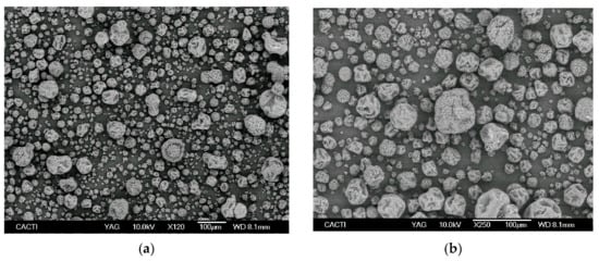
Peloids are thermotherapeutic agents used in several spas and thermal centers; their behavior depends on their physical properties, and these determine their forms of application. This work focuses on the study of the thermophysical properties of the mixtures of a clay, Laias mineral-medicinal
[...] Read more.
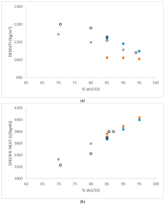
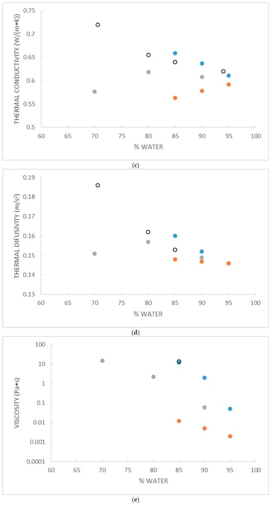
Peloids are thermotherapeutic agents used in several spas and thermal centers; their behavior depends on their physical properties, and these determine their forms of application. This work focuses on the study of the thermophysical properties of the mixtures of a clay, Laias mineral-medicinal water, and microalgae. The properties studied are density, specific heat, thermal conductivity, thermal diffusivity, and apparent viscosity as a function of the concentration of the water, at atmospheric pressure and a temperature of 308.15 K. The density of the mixtures was determined by a pycnometric method. The specific heat was determined using a CALVET microcalorimeter. A Decagon KD2 Pro conductivity meter was used to measure thermal conductivity. Thermal diffusivity was calculated from the data obtained on thermal conductivity, density and specific heat. Apparent viscosity measurements were carried out using a Schott rotational viscometer (Cole-Parmer, Vernon Hills, IL, USA). Results showed that the ternary mixtures with the highest percentage of mineral-medicinal water present the best thermotherapeutic behavior (95% water; Density: 1005 Kg/m3; Specific heat: 4037 J/kg K; Thermal conductivity: 0.592 W/m K; Thermal diffusivity: 0.146 × 10⁻⁶ m2/s; Apparent viscosity: 0.002 Pa s). The objective of this research is to contribute new knowledge in relation to microalgal peloid characteristics and their quality criteria concerned with therapeutic and wellness purposes, and how this could help in choosing the most suitable type of application for each mixture.
Full article
(This article belongs to the Special Issue Groundwater for Health and Well-Being)
►▼
Show Figures

Figure 1
Open AccessArticle
Sustainable IL-DLLME-ETAAS for Ultra-Trace Lead Analysis in the Mar Menor Lagoon
by
Irene Soler-García, Cristina Giner-Saura, Ignacio López-García and Yésica Vicente-Martínez
Water 2026, 18(18), 2249; https://doi.org/10.3390/w18182249 - 10 Sep 2026
Abstract
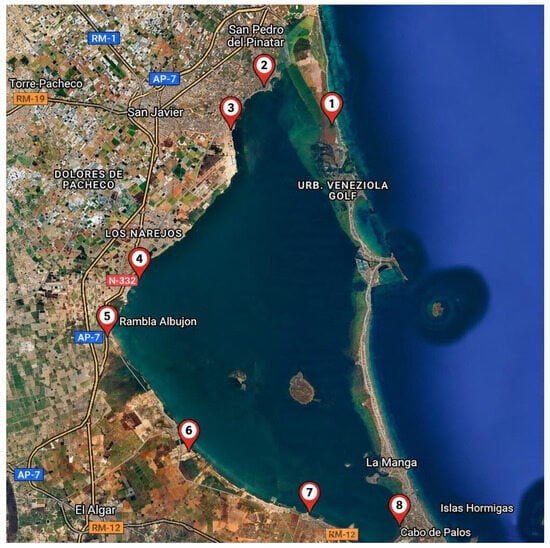
The Mar Menor, Europe’s largest coastal lagoon, faces severe ecological deterioration driven by nutrient loading, limited water renewal, and persistent contamination linked to mining residues from the Cartagena–La Unión district. Lead (Pb) levels remain an indicator of potential contamination caused by runoff from
[...] Read more.
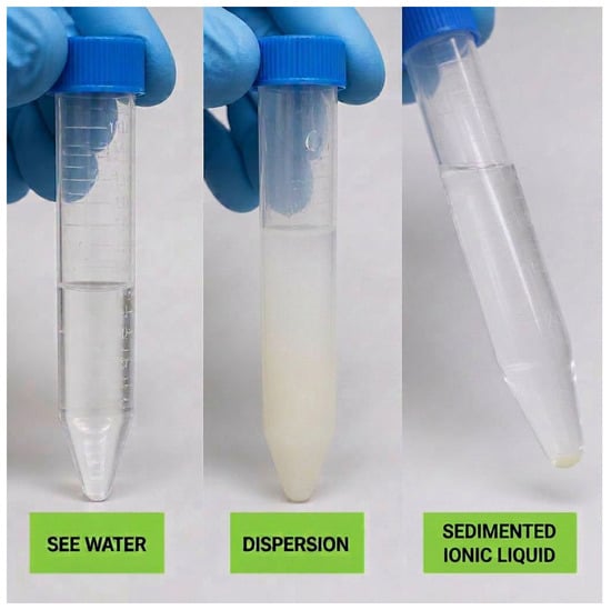
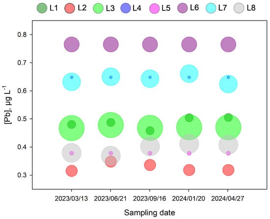
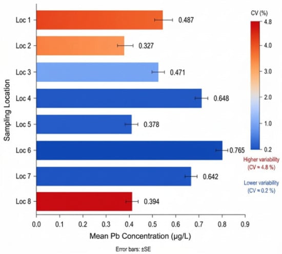
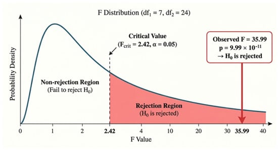
The Mar Menor, Europe’s largest coastal lagoon, faces severe ecological deterioration driven by nutrient loading, limited water renewal, and persistent contamination linked to mining residues from the Cartagena–La Unión district. Lead (Pb) levels remain an indicator of potential contamination caused by runoff from nearby abandoned mining operations and subsequent accumulation in marine organisms. This one-year study monitored total dissolved lead across eight representative locations using a rapid, simple analytical procedure combining ionic liquid dispersive liquid–liquid microextraction (IL-DLLME) and electrothermal atomic absorption spectrometry (ETAAS). The IL-DLLME system, based on in situ formation of the ionic liquid and APDC complexation, enabled highly efficient preconcentration, allowing the determination of ultra-trace Pb levels using low-cost instrumentation, achieving detection limits unattainable with previous monitoring techniques. Measured Pb concentrations ranged from 0.325 to 0.765 µg L−1, showing low temporal variability but marked spatial heterogeneity, with elevated values in confined or anthropogenically influenced areas. The one-way ANOVA test confirmed significant spatial differences (p < 0.001), indicating persistent localized inputs and limited dispersion. These results highlight the chronic influence of historical mining and demonstrate IL-DLLME-ETAAS as a sensitive, sustainable analytical alternative for ultra-trace metal monitoring. Continued surveillance is essential to evaluate ecological risks and guide restoration efforts.
Full article
(This article belongs to the Special Issue Emerging Contaminants in Water Environments: Occurrence, Analysis and Ecotoxicity)
►▼
Show Figures

Figure 1

Open AccessArticle
Adsorption of Rifampicin from Water Using Sawdust: Kinetics, Isotherms and Optimisation
by
Lekan Abudu, David K. Adeyemi, Joerg Arnscheidt, Svetlana Tretsiakova-McNally, Temilola Oluseyi, Luqman A. Adams and Heather M. Coleman
Water 2026, 18(18), 2248; https://doi.org/10.3390/w18182248 - 10 Sep 2026
Abstract
Residual antibiotics pollution is one of the main drivers of antibiotic resistance, demanding effective and sustainable technologies for remediation. Adsorption was found to be an effective process for antibiotic contaminant remediation, particularly on surfaces of lignocellulosic materials, which have gained attention as low-cost
[...] Read more.
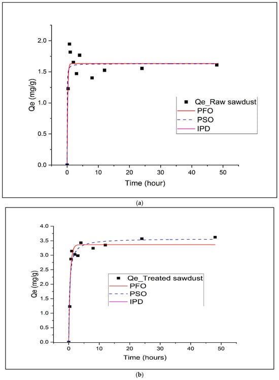
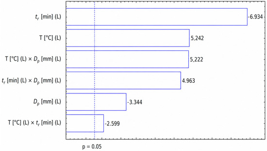
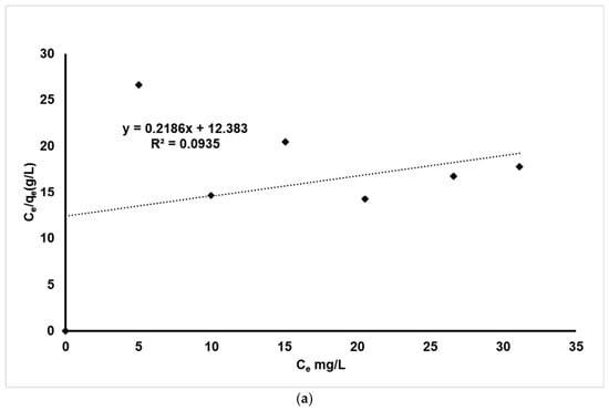
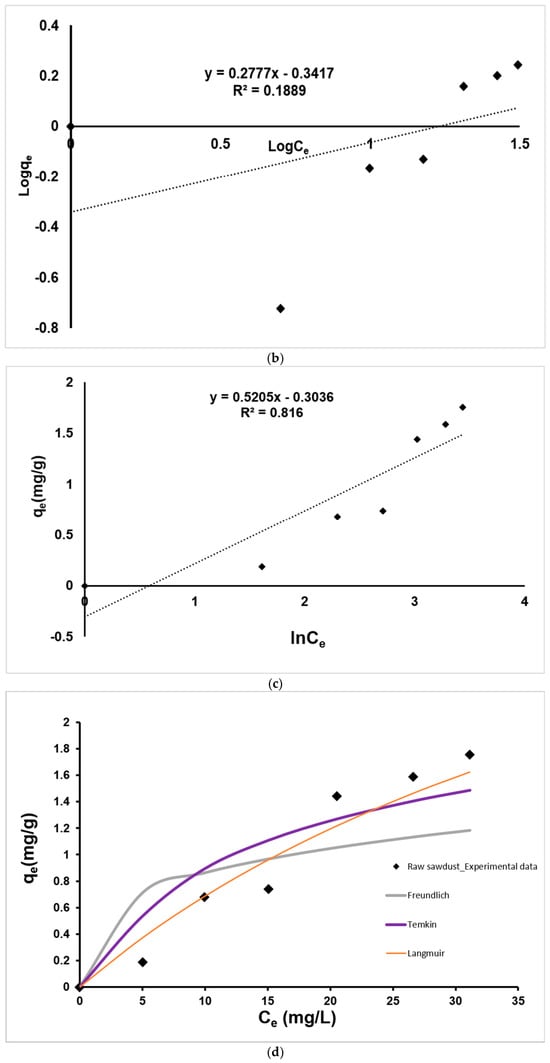
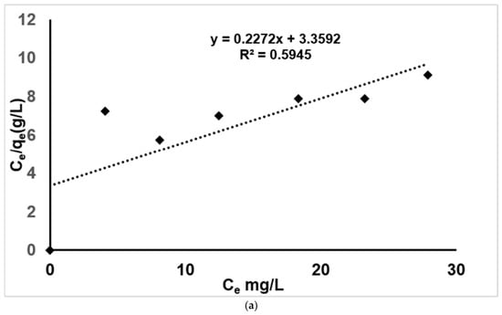
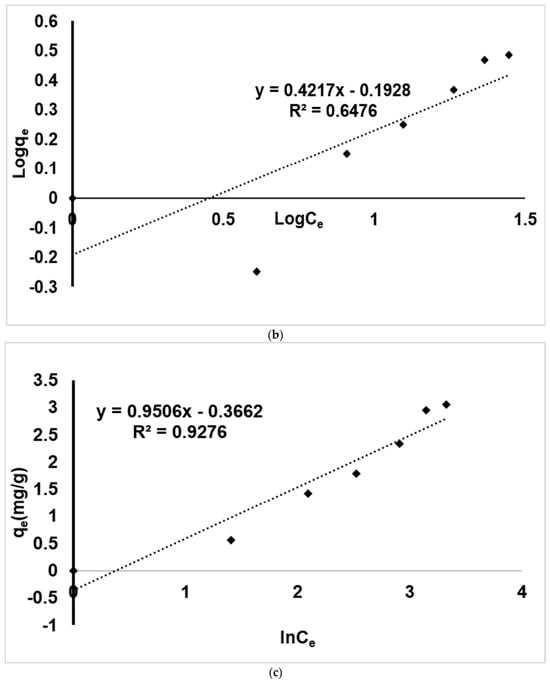
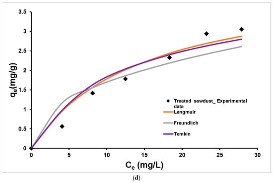
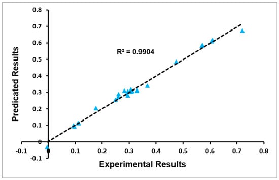
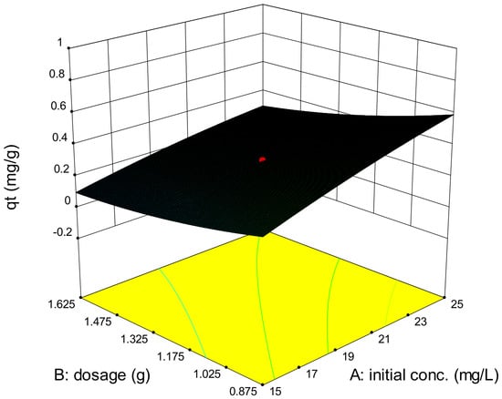
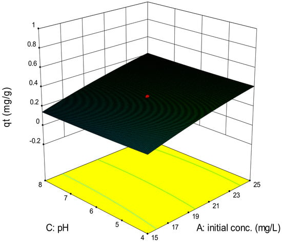
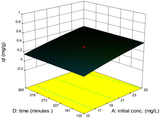
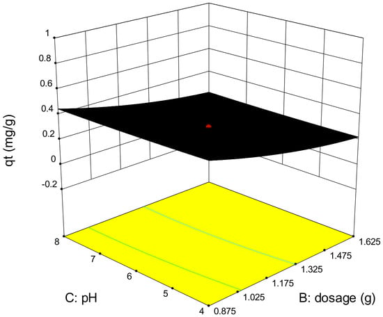
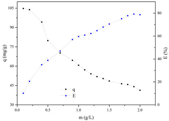
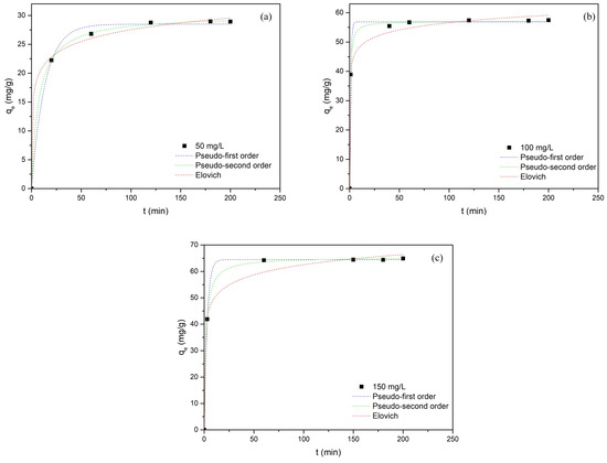
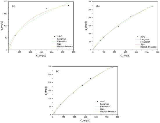
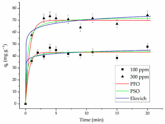
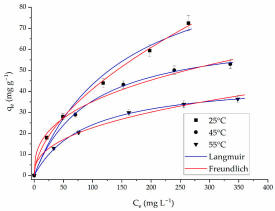
Residual antibiotics pollution is one of the main drivers of antibiotic resistance, demanding effective and sustainable technologies for remediation. Adsorption was found to be an effective process for antibiotic contaminant remediation, particularly on surfaces of lignocellulosic materials, which have gained attention as low-cost adsorbents. This study investigated the adsorption mechanisms and the optimisation of rifampicin removal from water using sawdust. Adsorption mechanisms were proposed based on kinetic and isotherms, while response surface methodology (RSM) was employed to optimise and identify the critical operating parameters. The results revealed that the adsorption of rifampicin by both adsorbents could be best described by the pseudo-first-order model, while the experimental results fitted perfectly into the Temkin isotherm model, which suggests that the adsorption of rifampicin on sawdust occurred via multi-interaction on a varying, energetically heterogeneous surface. Optimal conditions resulting in an uptake of 0.71 mg/g were established as follows: initial concentration of 20 mg/L, an adsorbent dosage of 0.5 g per 40 mL, pH 6 and at 250 min. The initial concentration of rifampicin and the adsorbent dosage were found to be the most critical parameters that influenced its uptake. The findings revealed that sawdust is a sustainable and cost-effective material to remove rifampicin from water, with adsorption occurring mainly via physisorption on a varying, energetically heterogeneous surface.
Full article
(This article belongs to the Special Issue Advanced Adsorption Technologies for the Removal of Organic Microcontaminants from Water and Wastewater)
►▼
Show Figures

Figure 1
Open AccessArticle
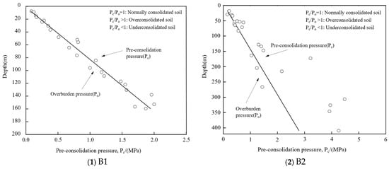
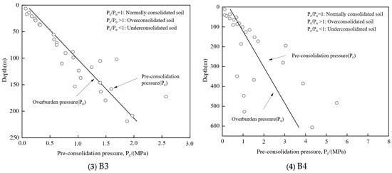
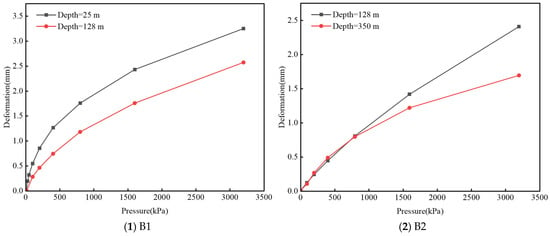
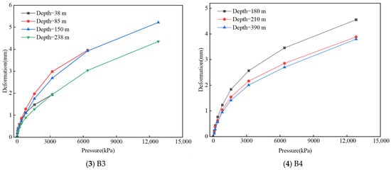
Compression–Rebound Behavior and Delayed Deformation Mechanism of Cohesive Soils Under Groundwater Level Fluctuations
by
Ling Yang, Shaomin Liu, Kunchao Lei and Mingzhou Bai
Water 2026, 18(18), 2247; https://doi.org/10.3390/w18182247 - 10 Sep 2026
Abstract
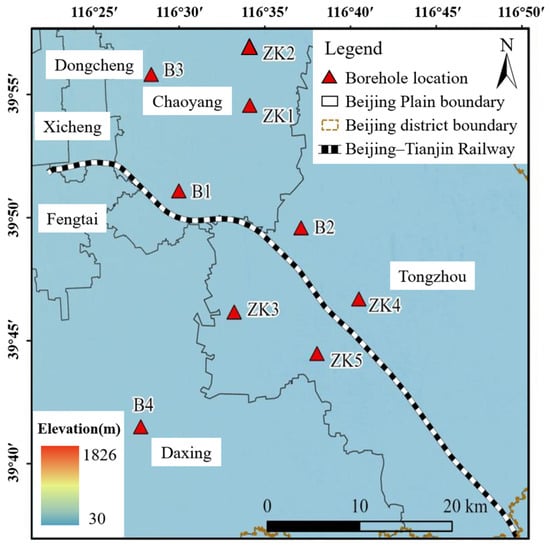
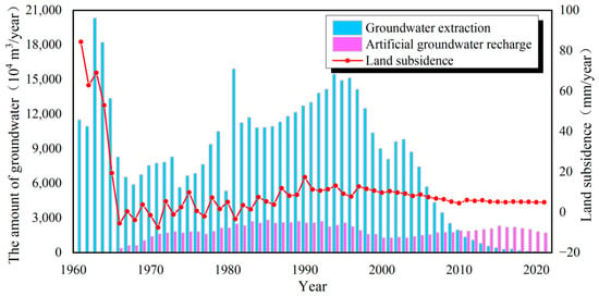
Long-term groundwater exploitation causes water-level fluctuations, which are a major driver of land subsidence and infrastructure deformation in sedimentary basins. To investigate the stress-history-dependent compression–rebound behavior of deep cohesive soils, soil samples along the Beijing–Tianjin High-Speed Railway were examined using high-pressure consolidation tests,
[...] Read more.
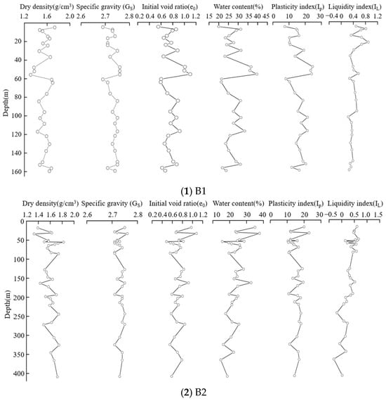
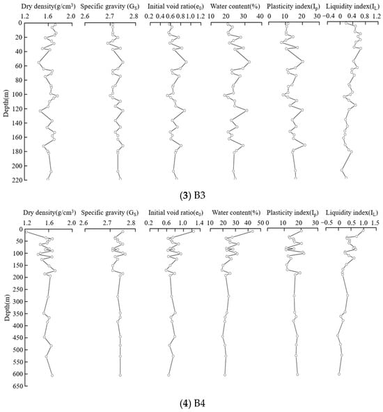
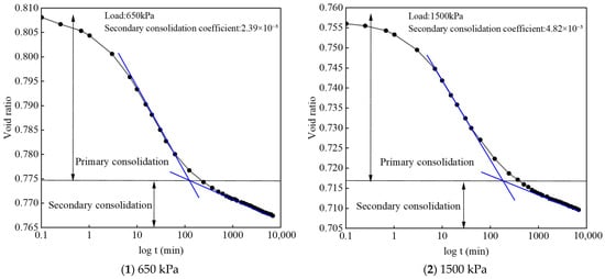
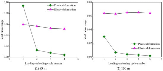
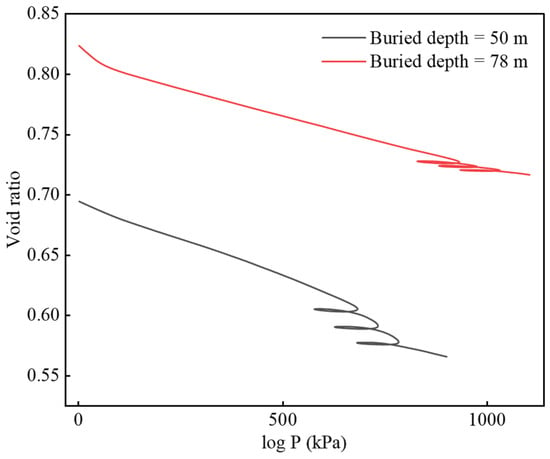
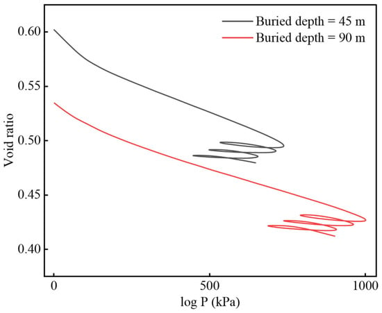
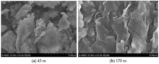
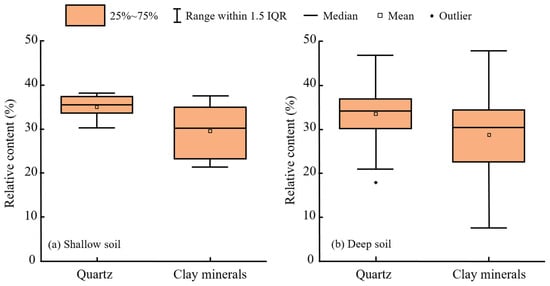
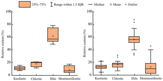
Long-term groundwater exploitation causes water-level fluctuations, which are a major driver of land subsidence and infrastructure deformation in sedimentary basins. To investigate the stress-history-dependent compression–rebound behavior of deep cohesive soils, soil samples along the Beijing–Tianjin High-Speed Railway were examined using high-pressure consolidation tests, cyclic loading–unloading tests, SEM, and XRD. Prescribed cyclic effective-stress paths were applied to simulate groundwater-level decline and recovery at different burial depths. The results showed that irreversible deformation was highly concentrated in the early loading stage. Under the groundwater-level decline paths, the first loading cycle alone accounted for approximately 77% and 94.8% of the total cumulative compression in the shallow and deep soils, respectively. During repeated loading–unloading between 0 and P0, the plastic deformation decreased significantly with cycle number, whereas the elastic deformation remained relatively stable. Under the groundwater-level rise paths, the cumulative rebound ratios were only 9.8% for the shallow soils and 17% for the deep soils, indicating that unloading recovered only a small fraction of the preceding compression. In terms of microstructure, the shallow soils had relatively loose and pore-rich fabrics, while the deeper soils exhibited denser particle packing and stronger interparticle contacts. These findings demonstrate pronounced mechanical irreversibility. Together with the measured low permeability, they support a mechanistic interpretation in which slow pore-pressure and effective-stress adjustments may further contribute to delayed deformation. Overall, this study provides a quantitative experimental characterization of the evolution of irreversible compression and incomplete recovery of deep cohesive soils under cyclic effective-stress changes induced by groundwater-level variations.
Full article
(This article belongs to the Topic Human Impact on Groundwater Environment, 2nd Edition)
►▼
Show Figures

Figure 1

Open AccessCorrection
Correction: Mannino et al. The Mediterranean Cystoseira Complex (Fucales, Ochrophyta): An Updated Illustrated Guide and Identification Key. Water 2026, 18, 1943
by
Anna Maria Mannino, Francesco Paolo Mancuso, Giuliana Marletta and Donatella Serio
Water 2026, 18(18), 2246; https://doi.org/10.3390/w18182246 - 10 Sep 2026
Abstract
In the original publication [...]
Full article
(This article belongs to the Special Issue Marine and Coastal Algae: Biodiversity, Invasive Species, and Ecosystem Conservation)
Open AccessArticle
Valorization of Spent Hops (Humulus lupulus L.) into Biochar and Activated Carbon: Characterization, Phenol Adsorption, and Cost Assessment
by
Natallia Britto Azevedo Souza, Micheli Legemann Monte, Keli Arruda da Silva, Daniele Gomes Müller, Daiane Dias, Nauro da Silveira Jr., Rafael Lipinski Paes, Débora Pez Jaeschke, Tito Roberto Sant’Anna Cadaval Jr. and Luiz Antonio de Almeida Pinto
Water 2026, 18(18), 2245; https://doi.org/10.3390/w18182245 - 9 Sep 2026
Abstract
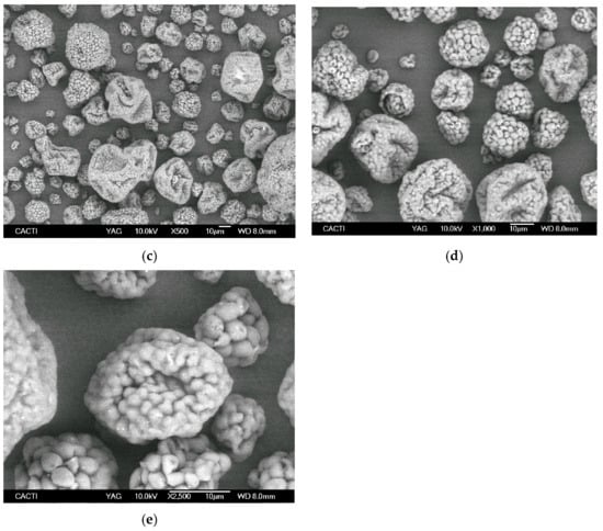
Spent hops generated during the dry-hopping stage of beer production were investigated as a precursor for the production of biochar and ZnCl2-activated carbon for phenol adsorption from aqueous solutions. The effects of production conditions on adsorption performance were evaluated through factorial
[...] Read more.
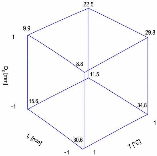
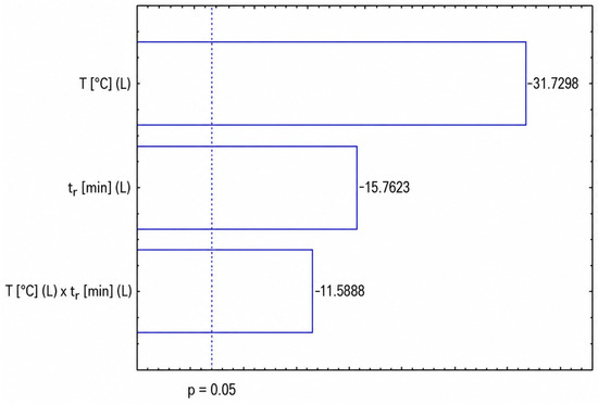
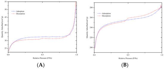
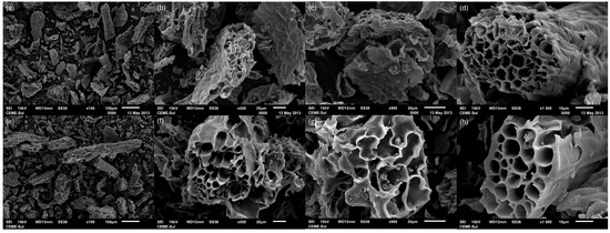
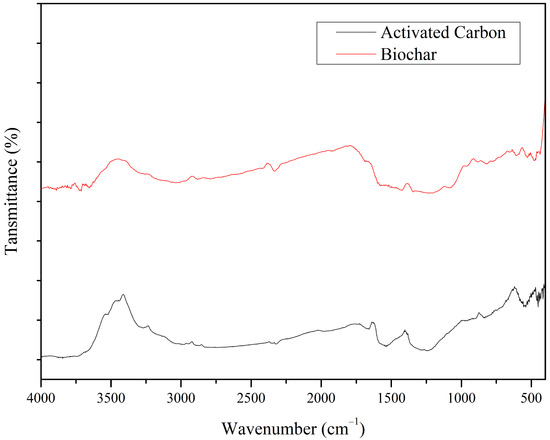
Spent hops generated during the dry-hopping stage of beer production were investigated as a precursor for the production of biochar and ZnCl2-activated carbon for phenol adsorption from aqueous solutions. The effects of production conditions on adsorption performance were evaluated through factorial experimental designs, and the resulting materials were characterized by SEM, FTIR, and N2 adsorption–desorption analyses. Chemical activation significantly enhanced the textural properties of the material, increasing the specific surface area from 113.6 to 755.9 m2 g−1 and the pore volume from 0.087 to 0.442 cm3 g−1 compared with biochar. FTIR analysis revealed the presence of oxygen-containing functional groups and aromatic structures that may contribute to phenol adsorption. The activated carbon produced under optimized conditions (700 °C, 30 min, and 130 μm particle size) exhibited an adsorption capacity of 57.32 mg g−1. Kinetic experiments showed rapid adsorption, with equilibrium reached within approximately 60 min, and the pseudo-second-order model provided the best fit to the experimental data (R2 = 0.999). Equilibrium studies demonstrated that adsorption capacity increased with temperature, reaching a Langmuir maximum adsorption capacity of 727.46 mg g−1 at 55 °C. Economic analysis showed that activated carbon presented a higher production cost than biochar (24.35 versus 13.40 US$ kg−1). However, its superior adsorption performance resulted in a lower performance-adjusted cost (0.516 versus 0.856 US$ g−1 of phenol adsorbed). These findings demonstrate that spent hops are a promising feedstock for the production of activated carbon, contributing to both wastewater treatment and the valorization of brewing-industry residues.
Full article
(This article belongs to the Special Issue Sustainable Biosorbents and Natural Coagulants for Water and Wastewater Treatment)
►▼
Show Figures

Figure 1
Open AccessArticle
Spatiotemporal Evolution and Driving Forces of Inter-Provincial Water Footprint Flow Networks in China: A Comparative Advantage Perspective
by
Xi Zheng, Xuezhong Tai, Mengyu Han and Qiuya Zhao
Water 2026, 18(18), 2244; https://doi.org/10.3390/w18182244 - 9 Sep 2026
Abstract
China’s rapid urbanization and industrialization have led to a severe shortage of water resources. China’s water scarcity problem is characterized by the mismatch between water resources, economic development, and the spatial distribution of production factors. Therefore, it is significant to study the complex
[...] Read more.
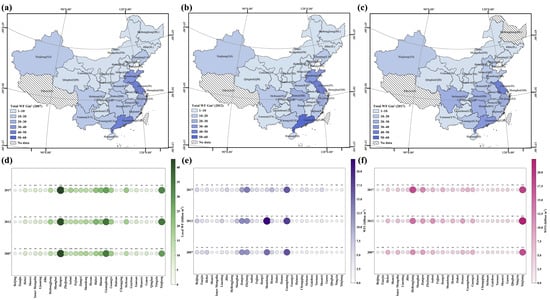
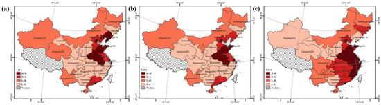
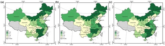
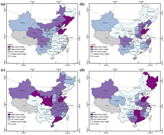
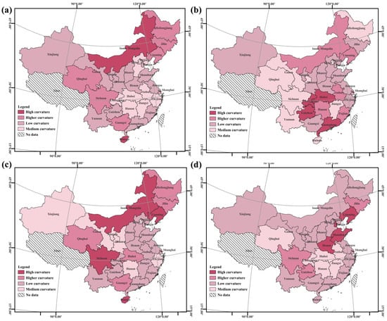
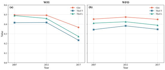
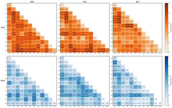
China’s rapid urbanization and industrialization have led to a severe shortage of water resources. China’s water scarcity problem is characterized by the mismatch between water resources, economic development, and the spatial distribution of production factors. Therefore, it is significant to study the complex dynamic relationship of water resource flow in space to alleviate regional water scarcity and realize sustainable development. In this study, the spatial effects and key influencing factors of the inter-provincial water-resource flow network in China were examined using water-resource consumption as a measure. The results show that the total water footprint showed an upward trend during the study period, and the water footprints of Xinjiang and Jiangsu were much higher than those of other regions. The hotspot areas of inter-provincial water footprint of inflow (WFI) were mainly concentrated in water-abundant areas, while the hotspot areas of water footprint of outflow (WFO) were concentrated in water-scarce areas, and the flow pattern lacked rationality. The local spatial structures of WFI and WFO were found to be relatively stable and showed a trend of synergistic change, with a higher degree of spatial agglomeration in WFO compared to WFI. Considering China’s future water resource security and sustainable development, economic development and scientific and technological inputs should play a more important role in alleviating pressure on the major water-resource-exporting provinces and optimizing the inter-provincial water-resource flow pattern.
Full article
(This article belongs to the Section Water Use and Scarcity)
►▼
Show Figures

Figure 1

Open AccessArticle
Micro-, Meso- and Unit-Scale Characterization of Shanghai Soft Soil Under Groundwater Level Fluctuations
by
Xiaotian Liu, Jianzhong Wu, Haoran Qian, Yansheng Deng, Yan Xu and Xinlei Huang
Water 2026, 18(18), 2243; https://doi.org/10.3390/w18182243 - 9 Sep 2026
Abstract
Coastal deltas worldwide are among the regions most vulnerable to land subsidence caused by intensive groundwater extraction, posing serious challenges to urban infrastructure and environmental sustainability. Shanghai exemplifies a typical coastal city experiencing severe land subsidence. Although groundwater abstraction has been strictly regulated
[...] Read more.
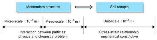
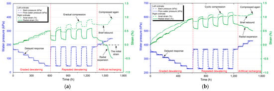
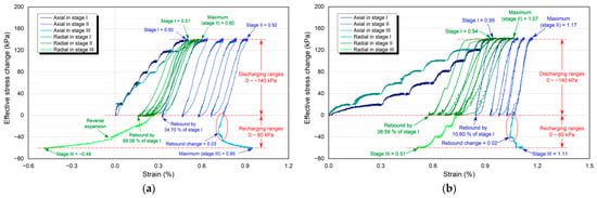
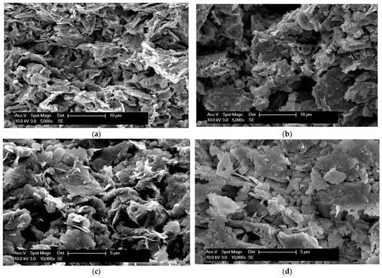
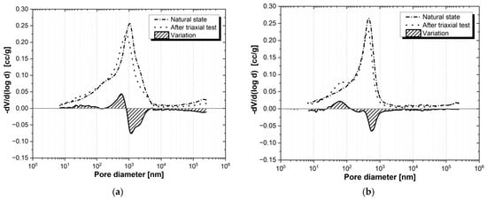
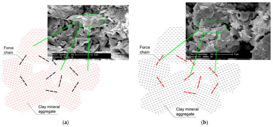
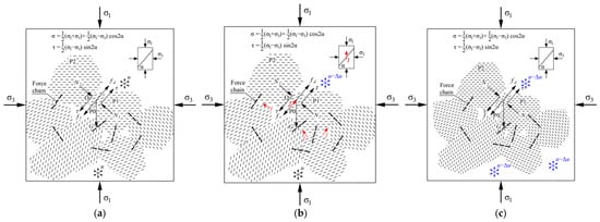
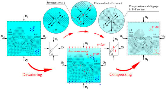
Coastal deltas worldwide are among the regions most vulnerable to land subsidence caused by intensive groundwater extraction, posing serious challenges to urban infrastructure and environmental sustainability. Shanghai exemplifies a typical coastal city experiencing severe land subsidence. Although groundwater abstraction has been strictly regulated and largely prohibited for most purposes, dewatering during deep excavations has become the primary cause of groundwater level fluctuations and the associated soil deformation. This study investigates the deformation mechanisms of Shanghai’s soft soil strata (layers ④ and ⑤3) under complex groundwater level fluctuations, using a multi-scale experimental approach. Stress-path-controlled triaxial tests were conducted to simulate staged dewatering, repeated dewatering, and artificial recharge processes. The results reveal an approximately linear stress–strain relationship during dewatering, with cumulative irreversible compression observed after cyclic loading. Partial deformation recovery occurred upon recharge, but only at relatively low pressure levels; once the recharge pressure exceeded a certain threshold, considerable axial compression was induced even as radial expansion continued. Microstructural analyses using an Environmental Scanning Electron Microscope (ESEM) and Mercury Intrusion Porosimetry (MIP) show that cyclic effective stress led to the fragmentation of clay aggregates and pore collapse, reducing total pore volume by approximately 10–17%. The deformation mechanism is attributed to the slippage and reorientation of clay particles under face-to-face (F–F) and line-to-face (L–F) contacts. These findings provide critical insights into the multi-scale behavior of soft soils under hydraulic stress and support the development of more sustainable land subsidence mitigation strategies in urban environments.
Full article
(This article belongs to the Section Hydrogeology)
►▼
Show Figures

Figure 1
Open AccessArticle
Variations in Surface-Water Nitrogen and Phosphorus Concentrations Across Land- and Water-Use Settings in a Plain River Network
by
Xingna Lin, Rong Zhang, Jiarui Li, Yuanfeng Yin, Ming Wu, Shengwu Jiao, Long Zhang, Zixin Fan, Jinlong Wu, Niu Li and Xuexin Shao
Water 2026, 18(18), 2242; https://doi.org/10.3390/w18182242 - 9 Sep 2026
Abstract
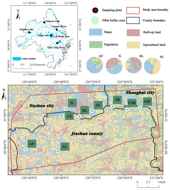
Excess nitrogen and phosphorus in surface water can degrade water quality and increase eutrophication risk. However, how surface-water nitrogen and phosphorus concentrations vary across mixed land- and water-use settings remains poorly understood in highly connected plain river networks, particularly under emerging water uses
[...] Read more.
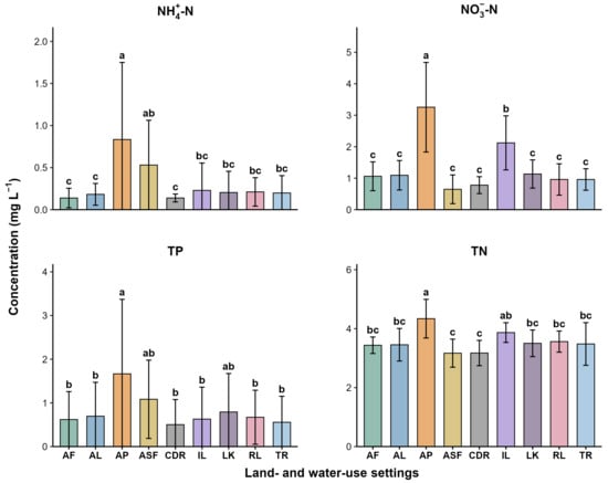
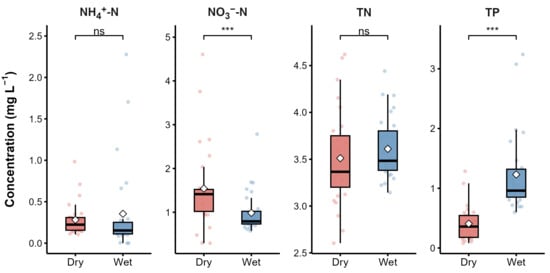
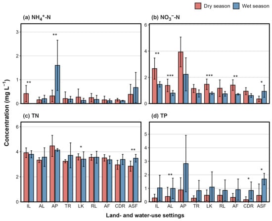
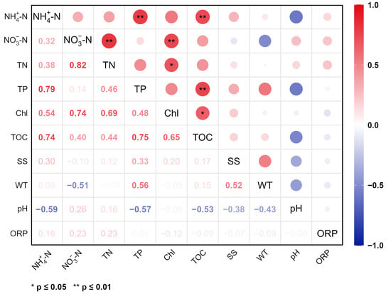
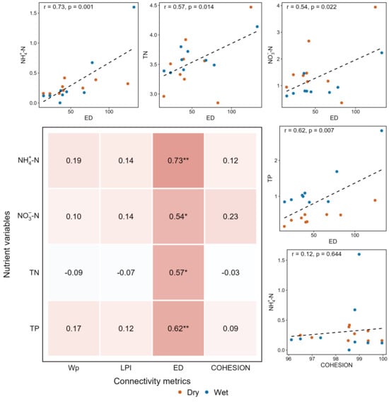
Excess nitrogen and phosphorus in surface water can degrade water quality and increase eutrophication risk. However, how surface-water nitrogen and phosphorus concentrations vary across mixed land- and water-use settings remains poorly understood in highly connected plain river networks, particularly under emerging water uses such as floating photovoltaic (FPV) installations. We investigated surface-water nitrogen and phosphorus concentrations across different land- and water-use settings in the Yangtze River Delta, focusing on seasonal variation and environmental controls. Field measurements were combined with Sentinel-2-derived waterbody metrics within 500 m buffers around sampling plots. Aquaculture ponds had the highest overall nutrient concentrations, industrial land showed relatively high nitrate–nitrogen (NO3−-N) and total nitrogen (TN), and aquatic solar farms exhibited a distinct nutrient pattern with relatively high total phosphorus (TP) but low TN. Nutrient forms showed contrasting seasonal patterns, with higher NO3−-N in the dry season and higher TP in the wet season. Water-surface proportion was weakly related to nutrient concentrations, whereas edge density was significantly correlated with them. These findings indicate that nutrient patterns were shaped by direct inputs, particle-associated transport, ecological and physicochemical conditions, and land–water interface effects. Nutrient management should therefore consider seasonal hydrology, local waterbody configuration, and emerging water-use types such as aquatic solar farms.
Full article
(This article belongs to the Section Water Quality and Contamination)
►▼
Show Figures

Figure 1

Open AccessArticle
Performance of Off-Level Tipping-Bucket Rain Gauges: A Laboratory Assessment
by
David Dunkerley
Water 2026, 18(18), 2241; https://doi.org/10.3390/w18182241 - 9 Sep 2026
Abstract
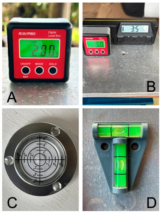
The performance and accuracy of tipping-bucket rain gauges (TBRGs) have been widely examined. However, whilst for proper operation TBRGs must be carefully levelled, to date there appears to be no published analysis of the errors that can arise in tilted gauges. Although tilt
[...] Read more.
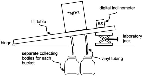
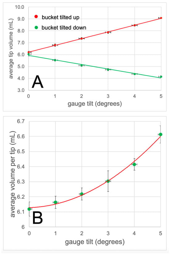
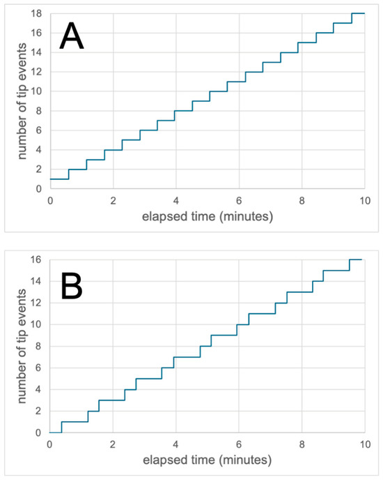
The performance and accuracy of tipping-bucket rain gauges (TBRGs) have been widely examined. However, whilst for proper operation TBRGs must be carefully levelled, to date there appears to be no published analysis of the errors that can arise in tilted gauges. Although tilt could exist in any direction with respect to the rotation axis of the buckets, the greatest effect occurs for tilt orthogonal to the rotation axis. Here, potential errors associated with tilt in this direction are analysed experimentally for the first time. Tests on a TBRG were made with the gauge carefully levelled, when inclined at inclinations of 1°, 2°, 3°, 4°, and 5°, and at several pumped flow rates equivalent to rainfall rates in the range 9.6–114.6 mm h−1. Results confirm that in a tilted TBRG, the buckets tip with unequal volumes of water. This results in the gauge requiring a progressively larger mean depth of rainfall to trigger tips as tilt increases, because the bucket tilted up requires more water to tip than the TBRG calibration would suggest, whilst the bucket tilted down requires less. Consequently, a tilted TBRG reports too few tips, and so under-reports the rainfall depth. The increase in the mean tipped volume is ~1% for a tilt of 1° and can exceed 8% for a tilt of 5°. The kinematic error associated with the TBRG mechanism is also shown to persist in tilted TBRGs, such that the potential aggregate error from both sources in a field installation may seriously degrade the quality of rainfall data.
Full article
(This article belongs to the Section Hydrology)
►▼
Show Figures

Figure 1

Open AccessArticle
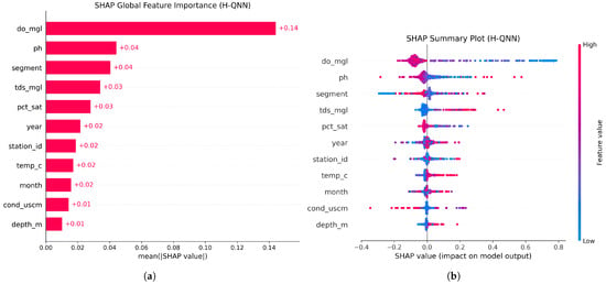
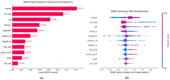
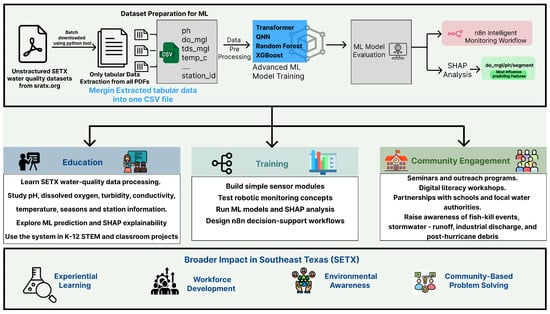
Water Quality Assessment Using Transformer, Quantum Neural Network, XGBoost, and Random Forest Models in an Agentic n8n Workflow with Applications in Maritime Robotics, Education, and Training
by
Nabin Bhandari, Md. Masud Rana, Wajiha Shireen, Mamta Singh and Clayton Jeffryes
Water 2026, 18(18), 2240; https://doi.org/10.3390/w18182240 - 9 Sep 2026
Abstract
Water quality monitoring is important for protecting aquatic life and supporting informed water quality assessment and environmental decision support. However, many existing systems mainly focus on data collection and threshold-based alerts, without connecting prediction, diagnosis, and intelligent assessment within a unified workflow. This
[...] Read more.
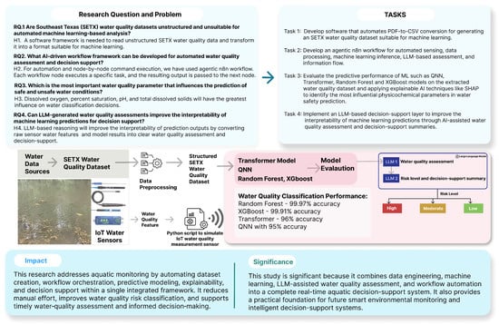
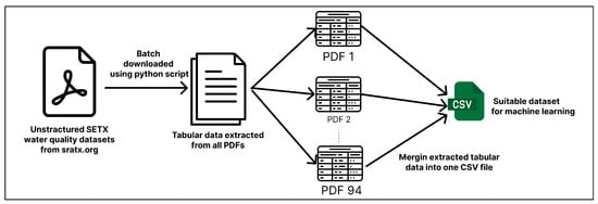
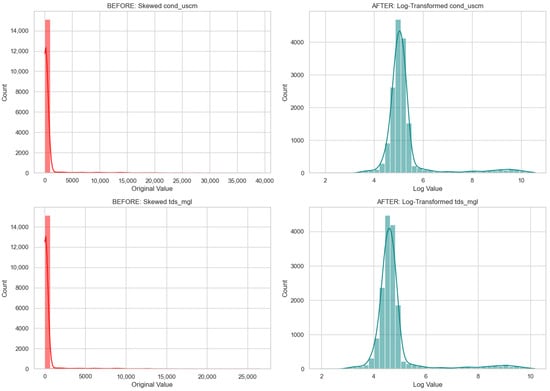
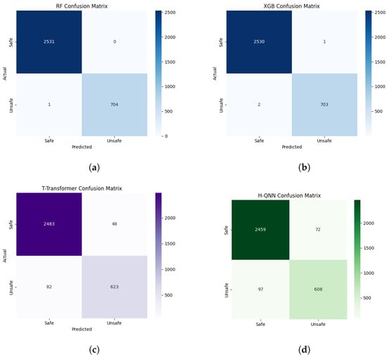
Water quality monitoring is important for protecting aquatic life and supporting informed water quality assessment and environmental decision support. However, many existing systems mainly focus on data collection and threshold-based alerts, without connecting prediction, diagnosis, and intelligent assessment within a unified workflow. This paper proposes an integrated smart aquatic monitoring system using Southeast Texas (SETX) water quality data, advanced machine learning models, large language models (LLMs), and an agentic n8n workflow. Firstly, SETX water quality data are extracted, cleaned, and converted into a structured CSV format. Important water features such as pH, dissolved oxygen, temperature, conductivity, and total dissolved solids are used to train and evaluate four different machine learning models, including Transformer, Quantum Neural Network (QNN), XGBoost, and Random Forest. The ML model is then deployed to a backend system for use inside the n8n automation workflow. For simulation, a Python script is designed to emulate an IoT water quality sensor by reading dataset records, converting valid records into JSON objects, and sending them to an agentic n8n webhook. The n8n workflow receives the sensor data and forwards it to the deployed model to predict surface water quality status. Across three simulations with three different datasets, the ML models demonstrate strong performance in classifying safe and unsafe water conditions. On the SETX dataset, Random Forest achieved the best performance, with 99.97% accuracy and a 99.95% macro F1-score. XGBoost also performed strongly, achieving 99.91% accuracy and a 99.86% macro F1-score. The Transformer model achieved 95.98% accuracy and a 94.00% macro F1-score, while the QNN model achieved 94.78% accuracy and a 92.24% macro F1-score. These results demonstrate that the processed SETX dataset supports reliable water quality prediction and can be integrated into the proposed n8n-based intelligent monitoring workflow. The prediction results are subsequently analyzed by an LLM-based diagnosis agent to generate an LLM-based water quality assessment, risk classification, and assessment summary that explain the prediction and highlight the most influential water quality parameters. The proposed system demonstrates a practical framework for combining sensor simulation, predictive modeling, LLM-based decision support, and agentic workflow automation for intelligent water quality assessment and smart environmental monitoring.
Full article
(This article belongs to the Section New Sensors, New Technologies and Machine Learning in Water Sciences)
►▼
Show Figures

Figure 1
Open AccessArticle
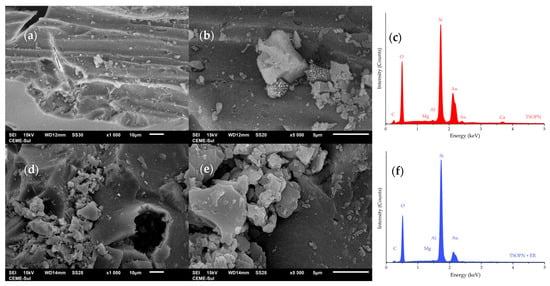
Adsorption of Erythrosine Red onto Silica Synthesized with Ora-Pro-Nobis as a Natural Porogenic Template: Equilibrium, Kinetic, and Thermodynamic Evaluation
by
Brenda G. Branchi, Cecília S. Fonseca, Clarissa Rosa, Bernardo Souza, Murilo C. Silveira, Maurício Z. F. Arlindo, Luiz H. Han, Cristiane dos Santos, João H. Z. Santos, Gilber R. Rosa, Débora P. Jaeschke, Luiz A. A. Pinto, Tito R. S. Cadaval Jr. and Nauro da Silveira Jr.
Water 2026, 18(18), 2239; https://doi.org/10.3390/w18182239 - 9 Sep 2026
Abstract
In this study, a silica-based adsorbent was synthesized via a two-step sol–gel route. A branch of ora-pro-nobis (Pereskia aculeata Miller) was used as a porogenic template. The biomass was incorporated into the silica matrix and subsequently removed by calcination. The resulting material
[...] Read more.
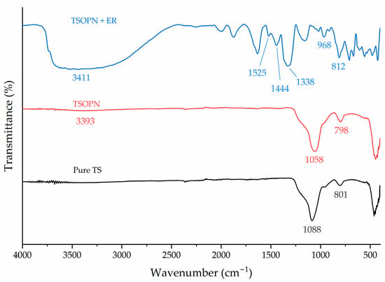
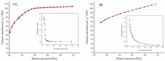
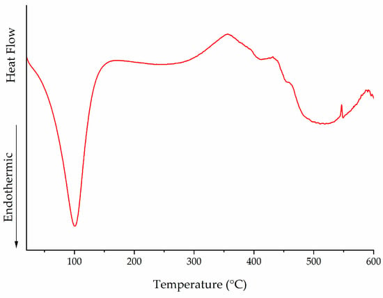
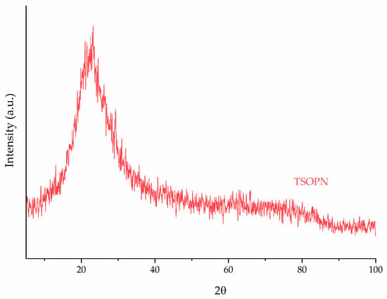
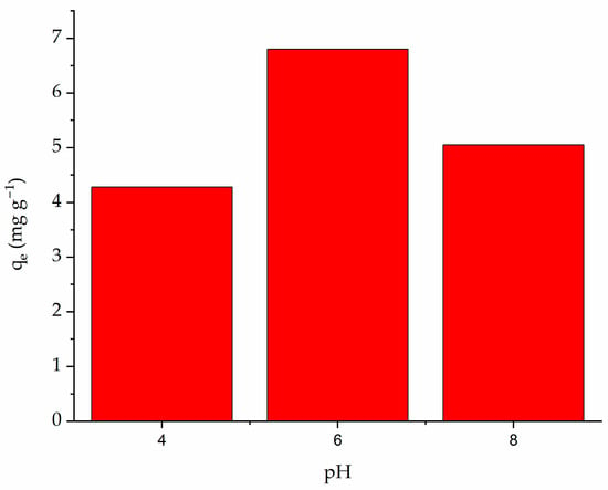
In this study, a silica-based adsorbent was synthesized via a two-step sol–gel route. A branch of ora-pro-nobis (Pereskia aculeata Miller) was used as a porogenic template. The biomass was incorporated into the silica matrix and subsequently removed by calcination. The resulting material was characterized by nitrogen adsorption–desorption analysis, scanning electron microscopy (SEM), Fourier-transform infrared spectroscopy (FTIR), X-ray diffraction (XRD), and differential scanning calorimetry (DSC), and its performance for erythrosine red adsorption from aqueous solution was evaluated. The incorporation of the biotemplate modified the pore structure of the silica, decreasing the BET specific surface area from 297.33 to 249.10 m2 g−1 while increasing the average BJH pore diameter from 2.26 to 3.66 nm. Adsorption was favored at pH 6 and rapidly approached equilibrium within approximately 5–7 min. The equilibrium data were satisfactorily described by the Langmuir model, with a maximum adsorption capacity of 108.81 mg g−1 at 25 °C. Adsorption capacity decreased with increasing temperature, and thermodynamic analysis indicated a spontaneous and exothermic process (ΔH° = −8.07 kJ mol−1). Overall, ora-pro-nóbis biomass acted as a renewable porogenic biotemplate, modifying the pore architecture of silica. The resulting TSOPN material exhibited competitive adsorption performance for erythrosine removal.
Full article
(This article belongs to the Section Wastewater Treatment and Reuse)
►▼
Show Figures

Figure 1
Open AccessArticle
Risk Assessment of Rainfall-Induced Debris Flow Based on HEC-RAS and GIS Technologies
by
Hao Lu, Qi Zhang, Qi Wan, Dongliang Huang, Peijie Yin and Zhiheng Zhu
Water 2026, 18(18), 2238; https://doi.org/10.3390/w18182238 - 9 Sep 2026
Abstract
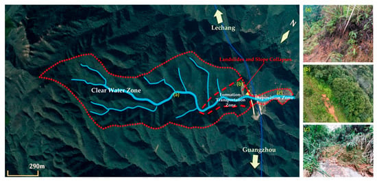
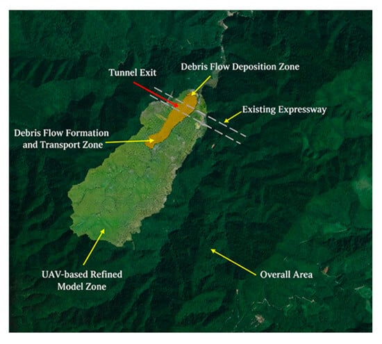
This paper investigates hazard assessment and mitigation measures for rainfall-induced debris flow at a highway tunnel portal in Guangdong, China. The tunnel is situated at the outlet of a steep gully with a channel length of 2.38 km, an elevation difference of 682
[...] Read more.
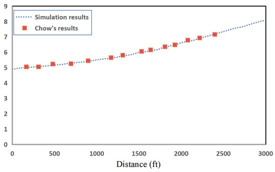
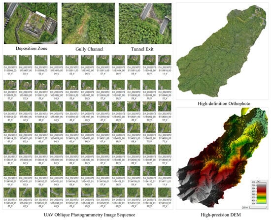
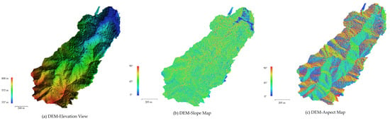
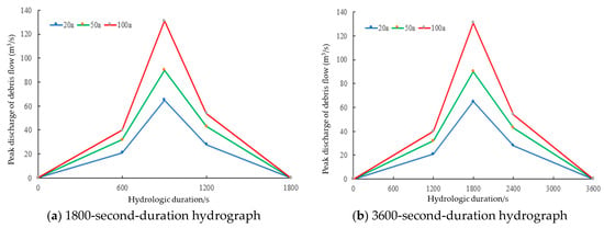
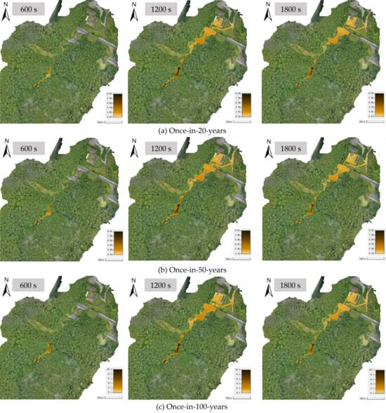
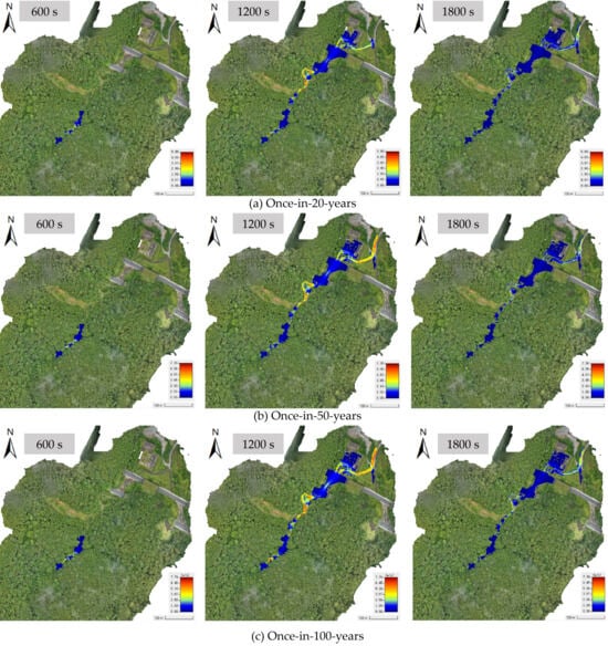
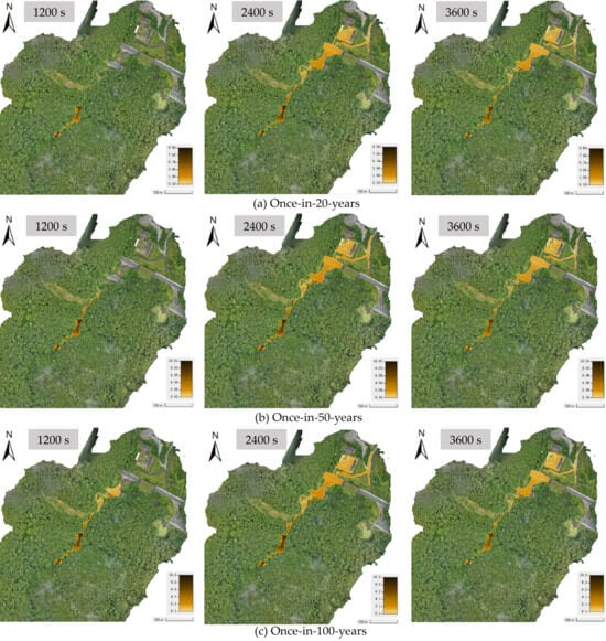
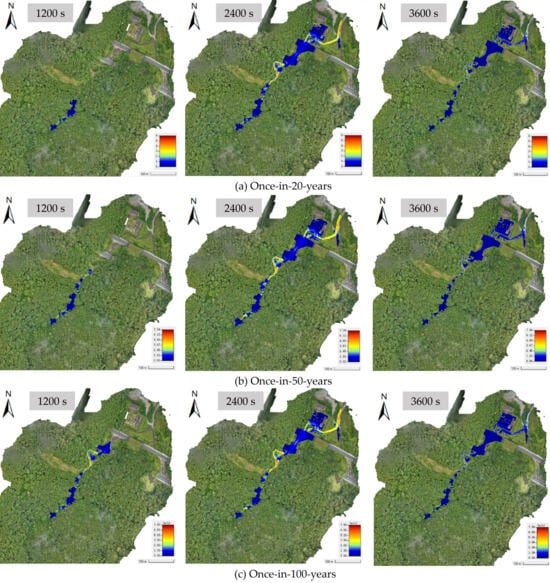
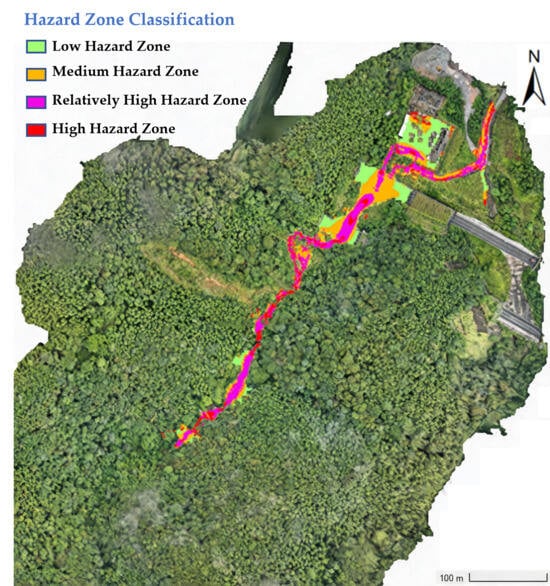
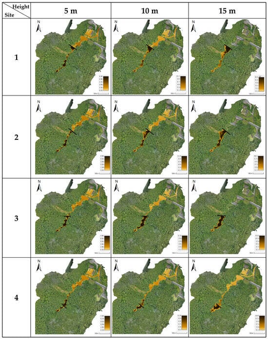
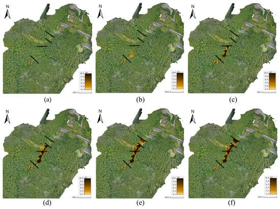
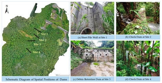
This paper investigates hazard assessment and mitigation measures for rainfall-induced debris flow at a highway tunnel portal in Guangdong, China. The tunnel is situated at the outlet of a steep gully with a channel length of 2.38 km, an elevation difference of 682 m, and a gradient of 23.4%. Under extreme rainfall conditions, the portal faces severe risks of scouring and inundation that threaten the structural safety and operational stability of the highway. A high-resolution digital elevation model was established via UAV oblique photogrammetry, and debris flow processes were simulated using HEC-RAS 6.4. The hydrologic behavior under 20-year, 50-year, and 100-year recurrence intervals is first investigated in the research area. After that, the Bingham flow model is used for the debris flow simulation. Results show that as the return period increases from 20 to 100 years, the maximum flow depth at the tunnel portal rises from 1.92 to 2.21 m and the maximum flow velocity rises from 5.8 to 7.8 m/s, indicating that flow velocity is more sensitive to rainfall intensity than flow depth. These simulated flow depths far exceed the 0.5 m flood level stipulated in the Chinese highway tunnel design code, indicating a serious threat to tunnel safety. Based on a quantitative comparison between single-dam and multi-dam schemes, a multi-dam combination with different heights at four positions along the gully is proposed for segmented interception. This multi-dam scheme successfully reduces the flow depth at the tunnel portal to zero without requiring any individual dam to exceed 10 m in height, demonstrating a favorable balance between engineering feasibility and disaster mitigation effectiveness.
Full article
(This article belongs to the Special Issue Hydrologically Induced Landslides: Mechanisms and Risk Assessment)
►▼
Show Figures

Figure 1
Open AccessArticle
Freeze–Thaw Effects on Baffle Friction in Ice–Rock Avalanche Mitigation: Experiments and Numerical Simulations
by
Jianjun Liang, Shijie Luo and Kaiyue Zhu
Water 2026, 18(18), 2237; https://doi.org/10.3390/w18182237 - 9 Sep 2026
Abstract
Rock–ice avalanches and repeated freeze–thaw cycles pose coupled challenges to baffle-type mitigation structures in high-altitude cold regions. This study used controlled small-scale pull-out tests to quantify changes in baffle–soil friction over 0–30 freeze–thaw cycles and then calibrated a discrete element method (DEM) model
[...] Read more.
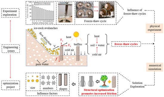
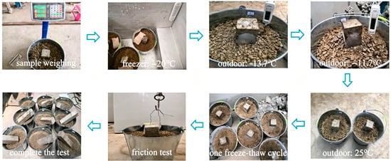
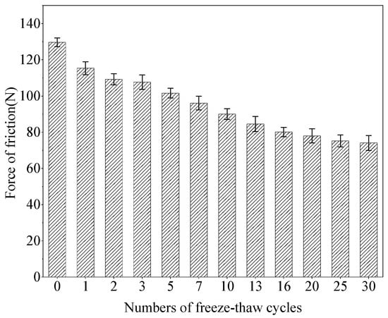
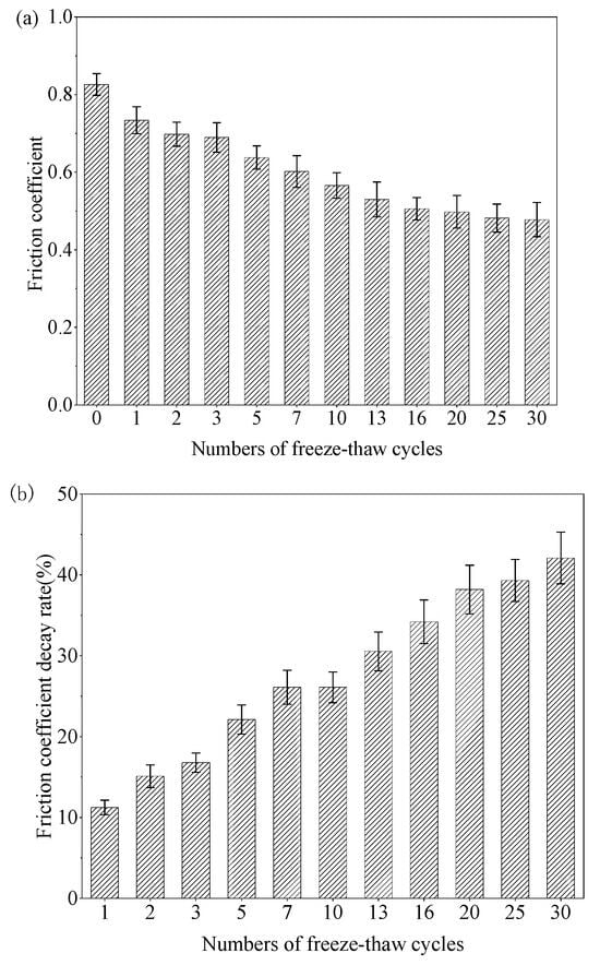
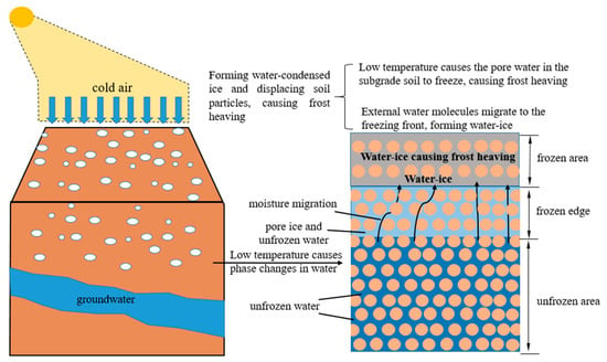
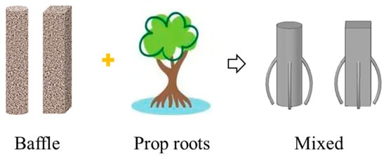
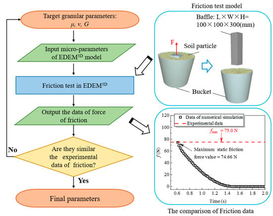
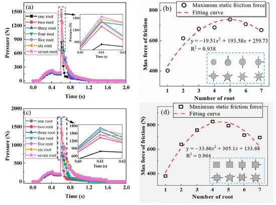
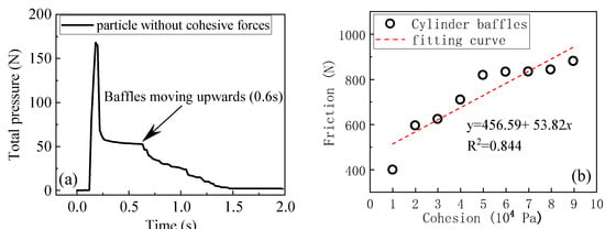
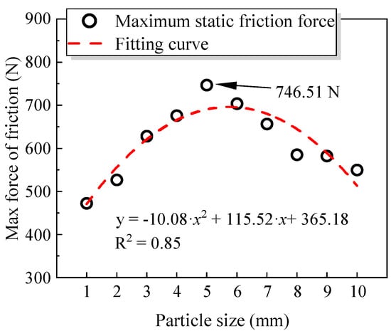
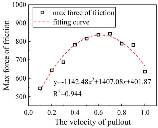
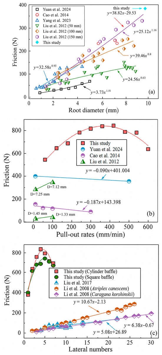
Rock–ice avalanches and repeated freeze–thaw cycles pose coupled challenges to baffle-type mitigation structures in high-altitude cold regions. This study used controlled small-scale pull-out tests to quantify changes in baffle–soil friction over 0–30 freeze–thaw cycles and then calibrated a discrete element method (DEM) model to the terminal 30-cycle condition to evaluate baffle geometry, particle size, interparticle cohesion, and pull-out velocity. Moisture redistribution approached equilibrium after approximately 7–10 cycles, whereas the friction response stabilized only after approximately 16 cycles, indicating that hydraulic stabilization preceded mechanical and interfacial stabilization. The friction coefficient decreased from 0.83 before cycling to 0.48 after 30 cycles, corresponding to an attenuation of 42.17%, and the friction force decreased from 130 to 75 N. The decay showed three stages: limited change over 0–3 cycles, accelerated degradation over 3–16 cycles, and a near-plateau thereafter. The DEM results indicate that lateral prop-root projections can increase pull-out resistance by enlarging the mobilized soil volume and enhancing mechanical interlocking; the response also depends nonlinearly on particle size and cohesion. The proposed baffle is therefore presented as a preliminary structural concept rather than a field-ready design. Because the experiments were not performed under complete geometric, kinematic, or dynamic similitude and the DEM calibration represents only one post-freeze–thaw state, the numerical values should be interpreted as laboratory-scale comparative results.
Full article
(This article belongs to the Special Issue Advanced Hydrological Modeling for Extreme Events: Floods, Droughts, and Risk Assessment)
►▼
Show Figures

Figure 1
Open AccessArticle
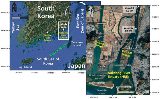
Field-Based Analysis of Saltwater Intrusion Distance, Arrival Time, and Stratification Index Following a Controlled Barrage Opening in the Nakdong River Estuary, South Korea
by
Jun-Ho Lee, Gi-Seop Lee, Hoi Soo Jung and Hong-Yeon Cho
Water 2026, 18(18), 2236; https://doi.org/10.3390/w18182236 - 9 Sep 2026
Abstract
Saltwater intrusion in regulated estuaries is commonly assessed using intrusion distance; however, its response to barrage operation may also depend on arrival timing, vertical stratification, and bathymetrically influenced near-bed transport. This study investigated these processes during a controlled saltwater intrusion experiment conducted on
[...] Read more.
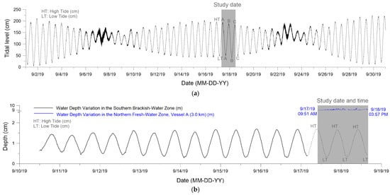
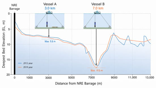
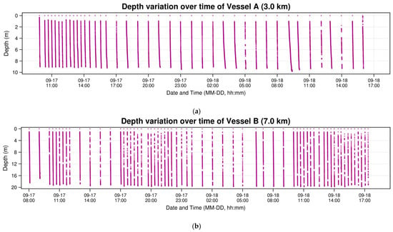
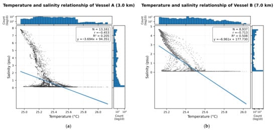
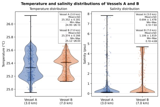
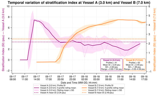
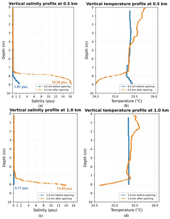
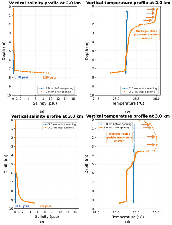
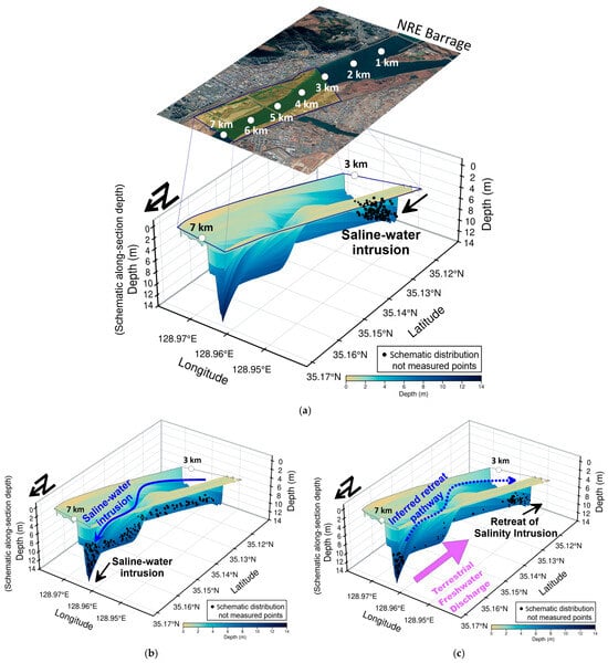
Saltwater intrusion in regulated estuaries is commonly assessed using intrusion distance; however, its response to barrage operation may also depend on arrival timing, vertical stratification, and bathymetrically influenced near-bed transport. This study investigated these processes during a controlled saltwater intrusion experiment conducted on 17–18 September 2019 in the freshwater reach upstream of the Nakdong River Estuary Barrage, South Korea. One barrage gate was opened for 51 min, with an officially reported seawater inflow of approximately 1.01 × 10⁶ t. Repeated vertical profiles of water temperature and salinity were collected at Vessels A and B (3.0, 7.0 km upstream). The salinity stratification index ( ) was defined as the difference between near-bottom and surface salinities. Before intrusion, salinity at both stations was approximately 0.1 psu. At Vessel A, near-bottom salinity increased abruptly at approximately 12:40 on 17 September, and the maximum recorded salinity later reached 7.83 psu. At Vessel B, near-bottom salinity began increasing progressively at approximately 20:00 on 17 September, and the maximum recorded salinity reached 4.69 psu at approximately 10:00 on 18 September. Saline water appeared earlier at Vessel A (3.0 km) and showed a substantially delayed response at Vessel B (7.0 km), indicating spatially heterogeneous adjustment of the saline bottom layer rather than uniform propagation. Mean values were psu at Vessel A and psu at Vessel B, confirming predominantly near-bed salt-wedge propagation beneath persistent freshwater surface flow. The observed bottom-intensified salinity structure was consistent with bathymetry-driven transport through deeper sections of the S-shaped channel, producing an abrupt intrusion at the 3.0 km station and delayed but sustained stratification at the 7.0 km station. Subsequent freshwater discharge is consistent with freshwater flushing, with an inferred retreat pathway involving seaward retreat and flushing of the saline layer, and the observed retreat pattern suggesting an influence of bathymetry. Surface salinity observations and single-distance criteria may underestimate saltwater penetration in regulated estuaries. Assessments should therefore consider intrusion distance, arrival time, vertical stratification, and near-bottom transport pathways.
Full article
(This article belongs to the Section Oceans and Coastal Zones)
►▼
Show Figures

Figure 1
Open AccessArticle
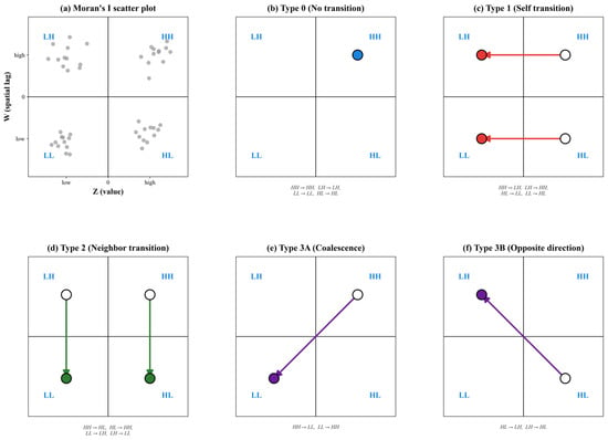
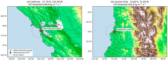
Machine Learning Post-Processing of Atmospheric River Persistence Forecasts: A Pre-Trained Tabular Transformer Across Mid-Latitude West Coasts
by
Heeseung Chung and Cheong Kim
Water 2026, 18(18), 2235; https://doi.org/10.3390/w18182235 - 9 Sep 2026
Abstract
Atmospheric river (AR)-driven flooding is a natural hazard that causes severe damage in many regions, and the damage escalates sharply once an AR persists beyond a certain duration. Existing studies and numerical weather prediction models, however, have focused mainly on AR occurrence and
[...] Read more.
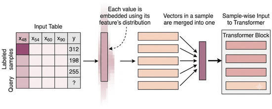
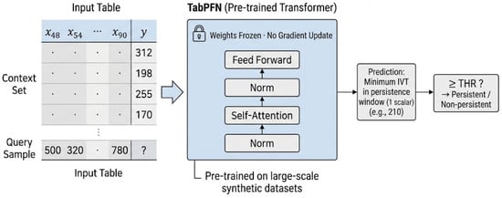
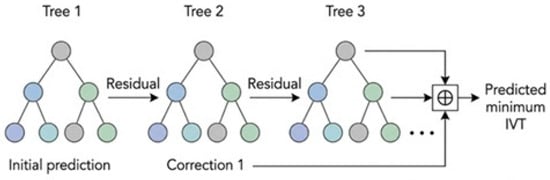
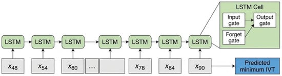
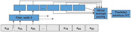
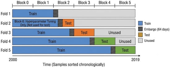
Atmospheric river (AR)-driven flooding is a natural hazard that causes severe damage in many regions, and the damage escalates sharply once an AR persists beyond a certain duration. Existing studies and numerical weather prediction models, however, have focused mainly on AR occurrence and on the intensity of integrated vapor transport (IVT) at individual time steps, paying little attention to duration. California and Chile are both exposed to severe AR-related hazards, yet for the period since 2000, the Global Ensemble Forecast System (GEFS) forecast at a two-day lead, compared against the regional IVT threshold, correctly predicts persistence for only about 30% of the ARs that actually persisted for 24 h or longer. This study retains the predictive capability of the physics-based GEFS forecast while correcting its weak performance on persistence using TabPFN, a pre-trained transformer for tabular data. Using single-control-member forecasts from the GEFS v12 reforecast (2000 to 2019), the model predicts the minimum IVT over the target window and compares it with the regional threshold. In the performance evaluation, the F1 score, which combines the precision and recall of AR persistence prediction into a single measure, rose from 0.414 to 0.502 and 0.601 in the two regions, and TabPFN outperformed machine learning models such as 1D-CNN and LGBM. Moreover, on the California coast, the proposed model, through its persistence decisions, captured 66.3% of the rainfall that fell during persistent atmospheric river events, up from 30.7% for the raw forecast. The proposed model offers a forecast post-processing method for predicting AR persistence and can contribute meaningfully to flood disaster prevention.
Full article
(This article belongs to the Special Issue Innovations in Hydrology: Streamflow and Flood Prediction)
►▼
Show Figures

Figure 1
Journal Menu
► ▼ Journal Menu-
- Water Home
- Aims & Scope
- Editorial Board
- Reviewer Board
- Topical Advisory Panel
- Early Career Editorial Board
- Instructions for Authors
- Special Issues
- Topics
- Sections
- Article Processing Charge
- Indexing & Archiving
- Editor’s Choice Articles
- Most Cited & Viewed
- Journal Statistics
- Journal History
- Journal Awards
- Society Collaborations
- Conferences
- Editorial Office
Journal Browser
► ▼ Journal BrowserHighly Accessed Articles
Latest Books
E-Mail Alert
News
3 April 2026
Meet Us Virtually at the 10th International Electronic Conference on Water Sciences, 24–27 November 2026
9 September 2026
International Day of Caves and Karst—“Explore, Understand and Protect: Towards Sustainable Management of Caves and Karst”, 13 September 2026
Topics
Topic in
Applied Sciences, Clean Technol., Energies, Membranes, Polymers, Sustainability, Water
New Advances in Membrane Technology and Its Contribution to Sustainability
Topic Editors: Patricia Luis Alconero, Bart Van der BruggenDeadline: 12 September 2026
Topic in
Agriculture, Climate, Energies, Land, Water
Energy, Environment and Climate Policy Analysis
Topic Editors: Xiaoqian Song, Jiajie LiDeadline: 30 September 2026
Topic in
Clean Technol., Materials, Molecules, Recycling, Water, Nanomaterials, Catalysts
Advanced Composites for Waste Valorization and Pollutant Degradation
Topic Editors: Iwona Kuzniarska-Biernacka, Ana Sofia MestreDeadline: 31 October 2026
Topic in
Applied Sciences, Hydrology, JMSE, Water, Eng
Hydraulic Engineering and Modelling
Topic Editors: Guohua Zhang, Feng Xiong, Xiaobo ZhangDeadline: 30 November 2026
Conferences
Special Issues
Special Issue in
Water
Hydrogeological and Hydrochemical Investigations of Aquifer Systems
Guest Editor: Lahcen ZouhriDeadline: 10 September 2026
Special Issue in
Water
Hydrodynamics and Sediment Transport in Ocean Engineering—Second Edition
Guest Editors: Zhipeng Zang, Ming ZhaoDeadline: 15 September 2026
Special Issue in
Water
Policy Innovation and Integrated Governance for Sustainable Urban Water Management
Guest Editors: Ziheng Shangguan, Eleni Zafeiriou, Mohd Yawar Ali KhanDeadline: 15 September 2026
Special Issue in
Water
Advancements in Anaerobic Digestion and Sustainable Sludge Management
Guest Editors: Weixin Zhao, Lili Li, Rupeng WangDeadline: 15 September 2026