Water 2023, 15(1), 20; https://doi.org/10.3390/w15010020 - 21 Dec 2022
Cited by 3 | Viewed by 3225
Abstract
The Shapotou National Nature Reserve in the Ningxia Hui Autonomous Region is a typical arid region in China. There is an exceptionally serious problem of surface water resource conservation, and dynamic monitoring of surface water with the help of water indices can help
[...] Read more.
The Shapotou National Nature Reserve in the Ningxia Hui Autonomous Region is a typical arid region in China. There is an exceptionally serious problem of surface water resource conservation, and dynamic monitoring of surface water with the help of water indices can help to elucidate its change patterns and impact mechanisms. Here, we analysed the characteristics of interannual variation in surface water area in the study area from 1992–2021. The correlation coefficients of the surface water area in the previous year and the contemporaneous water bodies of the Yellow River with the total surface water area (TSWA) were calculated. The results show the following: ① In terms of the classification accuracy of the two methods, water indices and support vector machine classification, water indices are more suitable for water body extraction in the study area. In particular, the three water indices, NDWI, MNDWI and AWEIsh, were more effective, with average overall accuracies of 90.38%, 90.33% and 90.36% over the 30-year period, respectively. ② From the TSWA extraction results from the last 30 years, the TSWA showed an increasing trend with an increase of 368.28 hm2. Among the areas, Tenggeli Lake contributed the most to the increase in TSWA. ③ The highest correlation between the TSWA and the previous year’s TSWA was 0.89, indicating that the better way to protect the water body is to maintain water surface stability year-round. The surface water area of the Yellow River and TSWA also showed a strong correlation, indicating that the rational use of Yellow River water is also an important direction for the future conservation of water resources in the study area.
Full article
(This article belongs to the Section Hydrology)
►
Show Figures
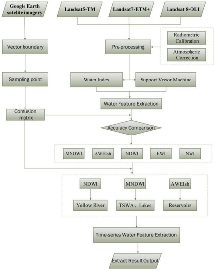
Figure 1


