23 pages, 6276 KiB  
Article
A Methodology for the Design of RTC Strategies for Combined Sewer Networks
by Stefan Kroll, Marjoleine Weemaes, Jan Van Impe and Patrick Willems
Water 2018, 10(11), 1675; https://doi.org/10.3390/w10111675 - 16 Nov 2018
Cited by 26 | Viewed by 5853
Abstract
While real-time control (RTC) is considered an established means of performance improvement for existing urban drainage networks, practical applications are frequently only documented for large case studies, and many operators are still reluctant to adopt RTC into their own systems. The purpose of [...] Read more.
While real-time control (RTC) is considered an established means of performance improvement for existing urban drainage networks, practical applications are frequently only documented for large case studies, and many operators are still reluctant to adopt RTC into their own systems. The purpose of the presented study is to highlight the potential of RTC also for smaller networks by the example of five representative catchments in Flanders, Belgium, and to demonstrate a novel methodology for the automated design of control strategies. This method analyses a given sewer network for the identification of suitable existing and new control locations. The gathered information is used in a second step for the design of control algorithms according to generic control concepts documented in the literature, such as e.g., “Equal Filling Degree”. The resulting RTC strategy uses sensible default parameters, and can form a starting point for further refinement through optimization or manual tuning. With a modelled total combined sewer overflow volume reduction of 20% to 50%, the created strategies showed generally good performance for the tested catchments. The method proved to be applicable for all tested networks. Its use for the real-life implementation of RTC is currently under way for 10 other Flemish cases. Full article
(This article belongs to the Section Urban Water Management)
Show Figures

Figure 1

18 pages, 2672 KiB  
Article
Hydraulic Jump and Resultant Flow Choking in a Circular Sewer Pipe of Steep Slope
by Chunli Wang and S. Samuel Li
Water 2018, 10(11), 1674; https://doi.org/10.3390/w10111674 - 16 Nov 2018
Cited by 8 | Viewed by 11073
Abstract
Urban flood caused by storm-water runoff has been problematic for many regions. There is a need to improve the design and hydraulic performance of storm sewer-pipes, which will help reduce the impact of urban flood. Such a need has motivated the current study. [...] Read more.
Urban flood caused by storm-water runoff has been problematic for many regions. There is a need to improve the design and hydraulic performance of storm sewer-pipes, which will help reduce the impact of urban flood. Such a need has motivated the current study. This paper investigates the flow behaviour in a circular pipe of steep slope, in which supercritical flow descends the steep terrain and forms a hydraulic jump under control acting downstream. So far, the jump behaviour and resultant flow choking in a circular pipe are poorly understood. This paper formulates the problem of the hydraulic jump in a circular pipe of slope on the basis of the momentum principle and solves it by using iterative methods. The solutions include the filling ratio and flow field downstream of an undular jump and a direct jump. For the first time, the Froude number’s dependence on the pipe slope has been quantified. For a given slope, it is possible to have two different filling ratios (or equivalently discharges) that associate with the same Froude number value. This paper reports detailed results of the initial versus sequent depth of the hydraulic jumps and quantitatively delineates the slope-filling ratio space between flow-choking and choking-free zones. For the design of storm sewers in a hilly area, it is necessary to correct the current design guidelines, which rely mostly on the uniform flow theory and suggest filling ratios as high as 85%. The corrections are either decreasing the filling ratio or increasing the pipe diameter to achieve choking-free flow in a circular pipe. Full article
(This article belongs to the Section Hydraulics and Hydrodynamics)
Show Figures

Figure 1

17 pages, 6817 KiB  
Article
Physical and Biological Water Column Observations during Summer Sea/Land Breeze Winds in the Coastal Northern Tyrrhenian Sea
by Riccardo Martellucci, Alberto Pierattini, Francesco Paladini De Mendoza, Cristiano Melchiorri, Viviana Piermattei and Marco Marcelli
Water 2018, 10(11), 1673; https://doi.org/10.3390/w10111673 - 16 Nov 2018
Cited by 7 | Viewed by 3417
Abstract
Coupling between sea/land breeze and coastal circulation and the influence of wind-driven dynamics are substantially relevant for understanding coastal Mediterranean ecosystems. These coastal areas are particularly dynamic and are characterized by high-variable processes which drive biological phenomena at different time-scales. For the Tyrrhenian [...] Read more.
Coupling between sea/land breeze and coastal circulation and the influence of wind-driven dynamics are substantially relevant for understanding coastal Mediterranean ecosystems. These coastal areas are particularly dynamic and are characterized by high-variable processes which drive biological phenomena at different time-scales. For the Tyrrhenian Sea, the available information on coastal dynamics is confined to large-scale general circulation with a focus exclusively on mesoscale pelagic dynamical processes. Hydrodynamic studies of Tyrrhenian coastal areas are very rare and focus on surface water circulation. For time scales that are associated with coastal water circulation, there is also limited knowledge on water column dynamics that are forced by local atmospheric circulations. This paper presents physical and biological data to document the effect of sea/land breeze circulation on ocean current dynamics and water column structures in a Northern Tyrrhenian coastal site. This coastal area is characterized by the presence of a relevant energy production site as well as one of the most important ports in the Mediterranean Sea for cruise traffic. Consequently, this coastal site is a transit point for many tourists and it is characterized by an increase of energy demand, especially during the summer season. The in-situ data show that coastal currents are predominantly controlled by the tide and local wind and respond rapidly to changes in wind direction. Water column thermal structure analyses reveal significant changes with the morning’s rotation of breeze: lifting of isotherms (cooling) was typically observed in deep layers during early mornings, accompanied by fluctuations in isotherms. The performed investigations provide valuable inputs for coastal ecosystem modeling and for a better understanding of the coastal processes that are significant for environmental and navigational interests. Full article
(This article belongs to the Section Hydrology)
Show Figures

Figure 1

15 pages, 3100 KiB  
Article
Potential Use of Dimocarpus longan Seeds as a Flocculant in Landfill Leachate Treatment
by Hamidi Abdul Aziz, Nor Aini Rahim, Siti Fatihah Ramli, Motasem Y. D. Alazaiza, Fatehah Mohd Omar and Yung-Tse Hung
Water 2018, 10(11), 1672; https://doi.org/10.3390/w10111672 - 16 Nov 2018
Cited by 51 | Viewed by 5570
Abstract
Landfill leachate is a highly polluted and generated from water infiltration through solid waste produced domestically and industrially. In this study, a coagulation–flocculation process using a combination of Polyaluminium chloride (PACl) as a coagulant and Dimocarpus longan seed powder (LSP) as coagulant aid [...] Read more.
Landfill leachate is a highly polluted and generated from water infiltration through solid waste produced domestically and industrially. In this study, a coagulation–flocculation process using a combination of Polyaluminium chloride (PACl) as a coagulant and Dimocarpus longan seed powder (LSP) as coagulant aid was used in treating landfill leachate. LSP has been tested as the main coagulant and as coagulant aid with PACl. As the main coagulant, the optimum dosage and pH for PACl were 5 g/L and 6, respectively, with removal efficiencies of 67.44%, 99.47%, and 98% for COD, SS, and color, respectively. For LSP as the main coagulant, results show that LSP is not effective where the removal efficiencies obtained for COD, SS, and color were 39.40%, 22.20%, and 28.30%, respectively, with the optimum dosage of 2 g/L and pH 4. The maximum removal efficiencies of COD, SS, and color were 69.19%, 99.50%, and 98.80%, respectively, when LSP was used as coagulant aid with PACl. Results show that using LSP as coagulant aid was found to be more effective in the removal of COD, SS, and color with less PACl dosage. The PACl dosage was decreased from 5 to 2.75 g/L when LSP was used as a coagulant aid. Cost estimation for using PACl alone and using LSP as the coagulant aid showed a reduction in the cost of approximately 40% of the cost of using PACl alone. Overall, this study confirmed the efficiency of LSP to be used as a natural coagulant aid in leachate treatment. Full article
(This article belongs to the Special Issue Water Quality Engineering and Wastewater Treatment)
Show Figures

Figure 1

32 pages, 5522 KiB  
Article
Drought Vulnerability Indices in Mexico
by David Ortega-Gaucin, Jesús De la Cruz Bartolón and Heidy V. Castellano Bahena
Water 2018, 10(11), 1671; https://doi.org/10.3390/w10111671 - 16 Nov 2018
Cited by 33 | Viewed by 9921
Abstract
Drought is one of the most harmful hydro climatic threats to society. Mexico has been historically affected by recurring and long-lasting droughts that have severely impacted society and the economy. Consequently, public programs and policies have been developed in order to reduce the [...] Read more.
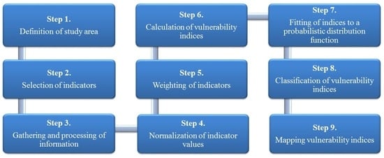
Drought is one of the most harmful hydro climatic threats to society. Mexico has been historically affected by recurring and long-lasting droughts that have severely impacted society and the economy. Consequently, public programs and policies have been developed in order to reduce the country’s vulnerability to drought, hence the importance of identifying the spatial distribution and the dimension—even in relative terms only—of vulnerability in different regions from social, economic, and environmental perspectives. This article presents a method for obtaining indices and maps of vulnerability to drought in Mexico; indices and maps are based on a set of socioeconomic and environmental indicators that the method combines using an objective analytic procedure that identifies the most vulnerable states and municipalities from social, economic, and environmental perspectives, all of which converge in overall vulnerability to drought. The results obtained indicate that 38.9% of total Mexican population inhabits municipalities with high and very high degrees of overall vulnerability to drought. For this reason, it is necessary to continue implementing actions and preventive and mitigation strategies via public policies and social programs aimed at decreasing the country’s vulnerability to the occurrence of drought events. This is the only way to facilitate the necessary conditions to reduce the impact of drought and to decrease people’s vulnerability to this phenomenon. Full article
(This article belongs to the Section Water Use and Scarcity)
Show Figures

Graphical abstract

17 pages, 3024 KiB  
Article
Impoundment Impact of the Three Gorge Reservoir on the Hydrological Regime in the Lower Han River, China
by Junhong Zhang, Luojie Feng, Sujie Chen, Tao Huang, Lu Chen, Dangwei Wang, Minglong Dai and Dongdong Zhang
Water 2018, 10(11), 1670; https://doi.org/10.3390/w10111670 - 16 Nov 2018
Cited by 9 | Viewed by 4464
Abstract
Reservoir regulation has been playing an increasingly important role in water resources development and its influence on the hydrological processes of downstream tributaries has attracted much attention. The lower Han River is selected as a case study to examine the hydrological and hydraulic [...] Read more.
Reservoir regulation has been playing an increasingly important role in water resources development and its influence on the hydrological processes of downstream tributaries has attracted much attention. The lower Han River is selected as a case study to examine the hydrological and hydraulic influence of the upstream flow regulation of the Three Gorges Reservoir (TGR) in the middle Yangtze River, China. Based on a hydrodynamic model and the observed data, the hydrological processes in the lower Han River were simulated and their changes were analyzed under the impoundment influences of the TGR. The results indicated that there were obviously hydrological changes in the lower Han River after the TGR operation. The decreased stage downstream the TGR during the impounding periods of the TGR resulted in an increase in the stage difference, current speed, hydraulic gradient and the discharge ratio. In addition, the stage difference between the two rivers was decreased during the periods of water compensation from the TGR, which led to the outflow congestion in the lower Han River. The hydrological changes in the lower Han River were the response to the flow regulation of the TGR and the inflow of the two rivers. The variation in the rating curve in the lower Han River mainly resulted from the stage difference between the two rivers during the dispatching periods of the TGR. These results help to explain the hydrological variability under the impounding influence of the TGR for the lower Han River and they can be extended to other river tributaries downstream to the reservoirs. Full article
(This article belongs to the Section Hydrology)
Show Figures

Figure 1

22 pages, 4644 KiB  
Article
Estimation of Peak Flow in Ungauged Catchments Using the Relationship between Runoff Coefficient and Curve Number
by Nam Won Kim and Mun-Ju Shin
Water 2018, 10(11), 1669; https://doi.org/10.3390/w10111669 - 16 Nov 2018
Cited by 20 | Viewed by 6214
Abstract
Hourly flood flow estimation for gauged and ungauged catchments is a prerequisite for planning and water management. Various methods have been applied in a multitude of studies to calculate the peak flow for ungauged catchments. However, it is not simple for engineers to [...] Read more.
Hourly flood flow estimation for gauged and ungauged catchments is a prerequisite for planning and water management. Various methods have been applied in a multitude of studies to calculate the peak flow for ungauged catchments. However, it is not simple for engineers to use the existing methods in practical applications. An easier method is suggested for this purpose in this study. The authors estimated the relationship between the runoff coefficient, intensity of rainfall, and curve number, and then utilized the relationship to calculated the peak flow using the rational method for ungauged catchments. Rainfall and flood time series for ungauged study catchments were generated by a simple data generation method and a distributed rainfall–runoff model. Results showed that the runoff coefficients simulated using the estimated relationship reasonably agree with the runoff coefficients in the studied ungauged catchments. In addition, the peak flow simulated using the rational method and the relationship highly agree with the peak flow in the ungauged catchments. Therefore, the peak flow in ungauged catchments can be easily calculated by this method, which is more pragmatic for engineers. Full article
(This article belongs to the Special Issue Catchment Modelling)
Show Figures

Figure 1

23 pages, 5086 KiB  
Article
The Influence of Climate and Land-Cover Scenarios on Dam Management Strategies in a High Water Pressure Catchment in Northeast Spain
by J. Zabalza-Martínez, S. M. Vicente-Serrano, J. I. López-Moreno, G. Borràs Calvo, R. Savé, D. Pascual, E. Pla, E. Morán-Tejeda, F. Domínguez-Castro and C. L. Tague
Water 2018, 10(11), 1668; https://doi.org/10.3390/w10111668 - 16 Nov 2018
Cited by 14 | Viewed by 5153
Abstract
This paper evaluates the response of streamflow in a Mediterranean medium-scaled basin under land-use and climate change scenarios and its plausible implication on the management of Boadella–Darnius reservoir (NE Spain). Land cover and climate change scenarios supposed over the next several decades were [...] Read more.
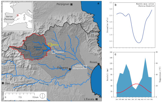
This paper evaluates the response of streamflow in a Mediterranean medium-scaled basin under land-use and climate change scenarios and its plausible implication on the management of Boadella–Darnius reservoir (NE Spain). Land cover and climate change scenarios supposed over the next several decades were used to simulate reservoir inflow using the Regional Hydro-Ecologic Simulation System (RHESsys) and to analyze the future impacts on water management (2021–2050). Results reveal a clear decrease in dam inflow (−34%) since the dam was operational from 1971 to 2013. The simulations obtained with RHESsys show a similar decrease (−31%) from 2021 to 2050. Considering the ecological minimum flow outlined by water authorities and the projected decrease in reservoir’s inflows, different water management strategies are needed to mitigate the effects of the expected climate change. Full article
Show Figures

Figure 1

18 pages, 3941 KiB  
Article
Application of Multiple Approaches to Investigate the Hydrochemistry Evolution of Groundwater in an Arid Region: Nomhon, Northwestern China
by Nuan Yang, Guangcai Wang, Zheming Shi, Dan Zhao, Wanjun Jiang, Liang Guo, Fu Liao and Pengpeng Zhou
Water 2018, 10(11), 1667; https://doi.org/10.3390/w10111667 - 16 Nov 2018
Cited by 47 | Viewed by 4751
Abstract
Groundwater is a critical water resource for human survival and economic development in arid and semi-arid areas. It is crucial to understand the groundwater circulation and hydrochemical evolution for sustainable management and utilization of groundwater resources in those areas. To this end, an [...] Read more.
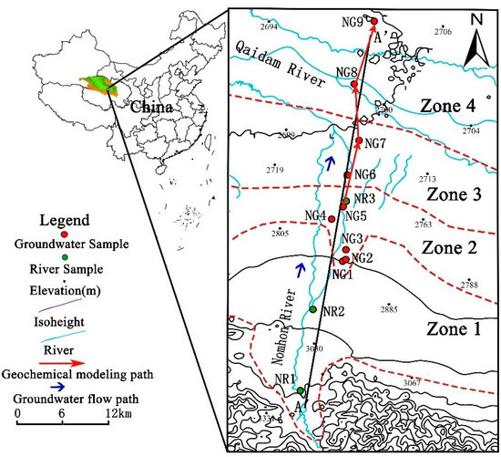
Groundwater is a critical water resource for human survival and economic development in arid and semi-arid areas. It is crucial to understand the groundwater circulation and hydrochemical evolution for sustainable management and utilization of groundwater resources in those areas. To this end, an investigation of the hydrochemical characteristics of surface water and groundwater was conducted in Nomhon, an arid area located in the Qaidam Basin, northwest China, by using hydrochemical (major and trace elements) and stable isotopes (δD and δ18O) approaches. Stable isotopes and ion ratios were analyzed to determine the recharge sources, hydrochemistry characteristics, and major hydrogeochemical processes. Meanwhile, inverse geochemistry modeling was applied to quantitatively determine the mass transfer of hydrogeochemical processes. The results showed that groundwater in the study area is mainly recharged by atmospheric precipitation in mountainous areas, and the groundwater in the center of basin might originate from ancient water in cold and humid environments. Along the groundwater flow path, the TDS of groundwater increased gradually from fresh to salty (ranging from 462.50 to 19,604.40 mg/L), and the hydrochemical type changed from Cl·HCO3–Na·Mg·Ca to Cl–Na. Groundwater chemical composition and mass balance modeling results indicated that from alluvial fan to lacustrine plain, the main hydrogeochemical processes changed from the dissolution of halite and albite and the precipitation of dolomite and kaolinite to the dissolution of halite and gypsum, precipitation of calcite, redox (SO42− reduction), and cation exchange. This study would be helpful for water resources management in this area and other similar areas. Full article
(This article belongs to the Special Issue Groundwater Resources Assessment: Quantity and Quality)
Show Figures

Figure 1

11 pages, 2449 KiB  
Article
Object-Based Convolutional Neural Networks for Cloud and Snow Detection in High-Resolution Multispectral Imagers
by Lei Wang, Yang Chen, Luliang Tang, Rongshuang Fan and Yunlong Yao
Water 2018, 10(11), 1666; https://doi.org/10.3390/w10111666 - 15 Nov 2018
Cited by 34 | Viewed by 4734
Abstract
Cloud and snow detection is one of the most significant tasks for remote sensing image processing. However, it is a challenging task to distinguish between clouds and snow in high-resolution multispectral images due to their similar spectral distributions. The shortwave infrared band (SWIR, [...] Read more.
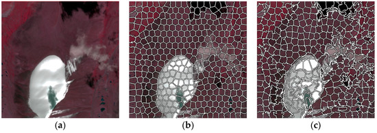
Cloud and snow detection is one of the most significant tasks for remote sensing image processing. However, it is a challenging task to distinguish between clouds and snow in high-resolution multispectral images due to their similar spectral distributions. The shortwave infrared band (SWIR, e.g., Sentinel-2A 1.55–1.75 µm band) is widely applied to the detection of snow and clouds. However, high-resolution multispectral images have a lack of SWIR, and such traditional methods are no longer practical. To solve this problem, a novel convolutional neural network (CNN) to classify cloud and snow on an object level is proposed in this paper. Specifically, a novel CNN structure capable of learning cloud and snow multiscale semantic features from high-resolution multispectral imagery is presented. In order to solve the shortcoming of “salt-and-pepper” in pixel level predictions, we extend a simple linear iterative clustering algorithm for segmenting high-resolution multispectral images and generating superpixels. Results demonstrated that the new proposed method can with better precision separate the cloud and snow in the high-resolution image, and results are more accurate and robust compared to the other methods. Full article
(This article belongs to the Special Issue Satellite Remote Sensing and Analyses of Climate Variability)
Show Figures

Figure 1

23 pages, 17100 KiB  
Article
Inter-Comparison of Rain-Gauge, Radar, and Satellite (IMERG GPM) Precipitation Estimates Performance for Rainfall-Runoff Modeling in a Mountainous Catchment in Poland
by Paweł Gilewski and Marek Nawalany
Water 2018, 10(11), 1665; https://doi.org/10.3390/w10111665 - 15 Nov 2018
Cited by 75 | Viewed by 8779
Abstract
Precipitation is one of the essential variables in rainfall-runoff modeling. For hydrological purposes, the most commonly used data sources of precipitation are rain gauges and weather radars. Recently, multi-satellite precipitation estimates have gained importance thanks to the emergence of Integrated Multisatellite Retrievals for [...] Read more.
Precipitation is one of the essential variables in rainfall-runoff modeling. For hydrological purposes, the most commonly used data sources of precipitation are rain gauges and weather radars. Recently, multi-satellite precipitation estimates have gained importance thanks to the emergence of Integrated Multisatellite Retrievals for Global Precipitation Measurement (IMERG GPM), a successor of a very successful Tropical Rainfall Measuring Mission (TRMM) mission which has been providing high-quality precipitation estimates for almost two decades. Hydrological modeling of mountainous catchment requires reliable precipitation inputs in both time and space as the hydrological response of such a catchment is very quick. This paper presents an inter-comparison of event-based rainfall-runoff simulations using precipitation data originating from three different sources. For semi-distributed modeling of discharge in the mountainous river, the Hydrologic Engineering Center-Hydrologic Modelling System (HEC-HMS) is applied. The model was calibrated and validated for the period 2014–2016 using measurement data from the Upper Skawa catchment a small mountainous catchment in southern Poland. The performance of the model was assessed using the Nash–Sutcliffe efficiency coefficient (NSE), Pearson’s correlation coefficient (r), Percent bias (PBias) and Relative peak flow difference (rPFD). The results show that for the event-based modeling adjusted radar rainfall estimates and IMERG GPM satellite precipitation estimates are the most reliable precipitation data sources. For each source of the precipitation data the model was calibrated separately as the spatial and temporal distributions of rainfall significantly impact the estimated values of model parameters. It has been found that the applied Soil Conservation Service (SCS) Curve Number loss method performs best for flood events having a unimodal time distribution. The analysis of the simulation time-steps indicates that time aggregation of precipitation data from 1 to 2 h (not exceeding the response time of the catchment) provide a significant improvement of flow simulation results for all the models while further aggregation, up to 4 h, seems to be valuable only for model based on rain gauge precipitation data. Full article
(This article belongs to the Section Hydrology)
Show Figures

Figure 1

19 pages, 7034 KiB  
Article
Inter-Sectoral Linkage and External Trade Analysis for Virtual Water and Embodied Carbon Emissions in China
by Huiping Huang, Xinsheng Li, Lianhai Cao, Dongdong Jia, Junlong Zhang, Chunying Wang and Yuping Han
Water 2018, 10(11), 1664; https://doi.org/10.3390/w10111664 - 15 Nov 2018
Cited by 12 | Viewed by 3745
Abstract
In the globalized world, water utilization and carbon emissions are two important indicators for water and energy resources evaluation. This paper investigates the inter-sectoral linkage and external trade of virtual water (water embodied in products) and embodied carbon emissions in China based on [...] Read more.
In the globalized world, water utilization and carbon emissions are two important indicators for water and energy resources evaluation. This paper investigates the inter-sectoral linkage and external trade of virtual water (water embodied in products) and embodied carbon emissions in China based on input–output tables during 1997–2015. Results indicate that: inside China, agriculture, the electric and water industry are major virtual water suppliers, while heavy industrial sectors including the metal products industry, the petrochemical industry, other nonmetallic mineral products industry, and the mining industry are major embodied carbon emissions suppliers. China is the net exporter of virtual water (137.15 × 10⁹ m3) and embodied carbon emissions (16.05 × 10⁸ t). From the perspective of industrial chain, about 81% of virtual water export come from agriculture, the electric and water industry ultimately, and about 85% of embodied carbon emissions export come from the mining industry, the petrochemical industry, other nonmetallic mineral products industry, the metal products industry, and the electric and water industry ultimately. Full article
(This article belongs to the Special Issue Energy and Water Nexus)
Show Figures

Figure 1

12 pages, 3151 KiB  
Article
Numerical Modeling of Flow Over a Rectangular Broad-Crested Weir with a Sloped Upstream Face
by Lei Jiang, Mingjun Diao, Haomiao Sun and Yu Ren
Water 2018, 10(11), 1663; https://doi.org/10.3390/w10111663 - 15 Nov 2018
Cited by 42 | Viewed by 12056
Abstract
The objective of this study was to evaluate the effect of the upstream angle on flow over a trapezoidal broad-crested weir based on numerical simulations using the open-source toolbox OpenFOAM. Eight trapezoidal broad-crested weir configurations with different upstream face angles (θ = [...] Read more.
The objective of this study was to evaluate the effect of the upstream angle on flow over a trapezoidal broad-crested weir based on numerical simulations using the open-source toolbox OpenFOAM. Eight trapezoidal broad-crested weir configurations with different upstream face angles (θ = 10°, 15°, 22.5°, 30°, 45°, 60°, 75°, 90°) were investigated under free-flow conditions. The volume-of-fluid (VOF) method and two turbulence models (the standard k-ε model and the SST k-w model) were employed in the numerical simulations. The numerical results were compared with the experimental results obtained from published papers. The root mean square error (RMSE) and the mean absolute percent error (MAPE) were used to evaluate the accuracy of the numerical results. The statistical results show that RMSE and MAPE values of the standard k-ε model are 0.35–0.67% and 0.50–1.48%, respectively; the RMSE and MAPE values of the SST k-w model are 0.25–0.66% and 0.55–1.41%, respectively. Additionally, the effects of the upstream face angle on the flow features, including the discharge coefficient and the flow separation zone, were also discussed in the present study. Full article
(This article belongs to the Section Hydraulics and Hydrodynamics)
Show Figures

Figure 1

22 pages, 6542 KiB  
Article
The Use of River Flow Discharge and Sediment Load for Multi-Objective Calibration of SWAT Based on the Bayesian Inference
by Qin-Bo Cheng, Xi Chen, Jiao Wang, Zhi-Cai Zhang, Run-Run Zhang, Yong-Yu Xie, Christian Reinhardt-Imjela and Achim Schulte
Water 2018, 10(11), 1662; https://doi.org/10.3390/w10111662 - 15 Nov 2018
Cited by 1 | Viewed by 3816
Abstract
The soil and water assessment tool (SWAT) is widely used to quantify the spatial and temporal patterns of sediment loads for watershed-scale management of sediment and nonpoint-source pollutants. However few studies considered the trade-off between flow and sediment objectives during model calibration processes. [...] Read more.
The soil and water assessment tool (SWAT) is widely used to quantify the spatial and temporal patterns of sediment loads for watershed-scale management of sediment and nonpoint-source pollutants. However few studies considered the trade-off between flow and sediment objectives during model calibration processes. This study proposes a new multi-objective calibration method that incorporates both flow and sediment observed information into a likelihood function based on the Bayesian inference. For comparison, two likelihood functions, i.e., the Nash–Sutcliffe efficiency coefficient (NSE) approach that assumes model residuals follow the Gaussian distribution, and the BC-GED approach that assumes model residuals after Box–Cox transformation (BC) follow the generalized error distribution (GED), are applied for calibrating the flow and sediment parameters of SWAT with the water balance model and the variable source area concept (SWAT-WB-VSA) in the Baocun watershed, Eastern China. Compared with the single-objective method, the multi-objective approach improves the performance of sediment simulations without significantly impairing the performance of flow simulations, and reduces the uncertainty of flow parameters, especially flow concentration parameters. With the NSE approach, SWAT-WB-VSA captures extreme flood events well, but fails to mimic low values of river discharge and sediment load, possibly because the NSE approach is an informal likelihood function, and puts greater emphasis on high values. By contrast, the BC-GED approach approximates a formal likelihood function, and balances consideration of the high- and low- values. As a result, inferred results of the BC-GED method are more reasonable and consistent with the field survey results and previous related-studies. This method even discriminates the nonerodible characteristic of main channels. Full article
(This article belongs to the Special Issue Watershed Hydrology, Erosion and Sediment Transport Processes )
Show Figures

Figure 1

19 pages, 4827 KiB  
Article
A New Well-Balanced Reconstruction Technique for the Numerical Simulation of Shallow Water Flows with Wet/Dry Fronts and Complex Topography
by Zhengtao Zhu, Zhonghua Yang, Fengpeng Bai and Ruidong An
Water 2018, 10(11), 1661; https://doi.org/10.3390/w10111661 - 14 Nov 2018
Cited by 7 | Viewed by 3116
Abstract
This study develops a new well-balanced scheme for the one-dimensional shallow water system over irregular bed topographies with wet/dry fronts, in a Godunov-type finite volume framework. A new reconstruction technique that includes flooded cells and partially flooded cells and preserves the non-negative values [...] Read more.
This study develops a new well-balanced scheme for the one-dimensional shallow water system over irregular bed topographies with wet/dry fronts, in a Godunov-type finite volume framework. A new reconstruction technique that includes flooded cells and partially flooded cells and preserves the non-negative values of water depth is proposed. For the wet cell, a modified revised surface gradient method is presented assuming that the bed topography is irregular in the cell. For the case that the cell is partially flooded, this paper proposes a special reconstruction of flow variables that assumes that the bottom function is linear in the cell. The Harten–Lax–van Leer approximate Riemann solver is applied to evaluate the flux at cell faces. The numerical results show good agreement with analytical solutions to a set of test cases and experimental results. Full article
(This article belongs to the Section Hydraulics and Hydrodynamics)
Show Figures

Figure 1