Remote Sens. 2021, 13(18), 3720; https://doi.org/10.3390/rs13183720 - 17 Sep 2021
Cited by 27 | Viewed by 6122
Abstract
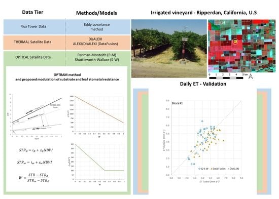
A new approach is proposed to derive evapotranspiration (E) and irrigation requirements by implementing the combination equation models of Penman–Monteith and Shuttleworth and Wallace with surface parameters and resistances derived from Sentinel-2 data. Surface parameters are derived from Sentinel-2 and used as an
[...] Read more.
A new approach is proposed to derive evapotranspiration (E) and irrigation requirements by implementing the combination equation models of Penman–Monteith and Shuttleworth and Wallace with surface parameters and resistances derived from Sentinel-2 data. Surface parameters are derived from Sentinel-2 and used as an input in these models; namely: the hemispherical shortwave albedo, leaf area index and water status of the soil and canopy ensemble evaluated by using a shortwave infrared-based index. The proposed approach has been validated with data acquired during the GRAPEX (Grape Remote-sensing Atmospheric Profile and Evapotranspiration eXperiment) in California irrigated vineyards. The E products obtained with the combination equation models are evaluated by using eddy covariance flux tower measurements and are additionally compared with surface energy balance models with Landsat-7 and -8 thermal infrared data. The Shuttleworth and Wallace (S-W S-2) model provides an accuracy comparable to thermal-based methods when using local meteorological data, with daily E errors < 1 mm/day, which increased from 1 to 1.5 mm/day using meteorological forcing data from atmospheric models. The advantage of using the S-W S-2 modeling approach for monitoring ET is the high temporal revisit time of the Sentinel-2 satellites and the finer pixel resolution. These results suggest that, by integrating the thermal-based data fusion approach with the S-W S-2 modeling scheme, there is the potential to increase the frequency and reliability of satellite-based daily evapotranspiration products.
Full article
(This article belongs to the Section Remote Sensing in Agriculture and Vegetation)
►
Show Figures
Graphical abstract


