1
Department of Land Resource Management, School of Public Administration, China University of Geosciences, Wuhan 430074, China
2
Key Labs of Law Evaluation of Ministry of Land and Resources of China, 388 Lumo Road, Hongshan District, Wuhan 430074, China
3
Collaborative Innovation Center for Emissions Trading System Co-Constructed by the Province and Ministry, Hubei University of Economics, Wuhan 430205, China
4
School of Low Carbon Economics, Hubei University of Economics, Wuhan 430205, China
Remote Sens. 2023, 15(5), 1426; https://doi.org/10.3390/rs15051426 - 3 Mar 2023
Cited by 8 | Viewed by 2672
| Correction
Abstract
▼
Show Figures
This study investigates whether the intensity of human activities conducted by urban populations and carried by urban land follows a wave-shaped diffusion rule using a harmonized DMSP-like NTL dataset during 1992–2018 in 234 cities of China. The results show that variations in the
[...] Read more.
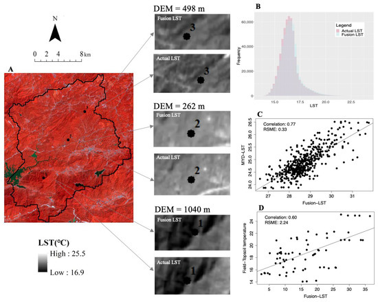
This study investigates whether the intensity of human activities conducted by urban populations and carried by urban land follows a wave-shaped diffusion rule using a harmonized DMSP-like NTL dataset during 1992–2018 in 234 cities of China. The results show that variations in the intensity of human activities are diffused in a wave-shaped manner from the urban center to the periphery in cities of different sizes and structures. The results demonstrate that variations in the intensity of human activity also exhibit a wave-shaped diffusion pattern, which is best modeled by a Gaussian function with an average R2 of 0.79 and standard deviation of 0.36 across all fitted functions. The outward movement of these waves in monocentric cities with an urban population <8 million occurred at a pace of ~0.5–1.0 km per year, reaching an average distance of ~18 km from the urban centers. While the pace decreased to ~0.2–0.6 km per year in larger or polycentric cities, the average distance of the waves from the urban centers increased to ~22–25 km in these larger cities. In addition, a process-pattern link between the distance-decayed rule and the wave-shaped rule of human activity dynamics was established. Moreover, a spatiotemporal Gaussian function was further discussed to enable modelers to forecast future variations in the intensity of human activities. The disclosed wave-shape rule and model can benefit the simulation of urban dynamics if integrated with other simulation technologies, such as agent-based models and cellular automata.
Full article

Figure 1


