by
Weikang Zhang 1,2 , Haihang You 1,2,*, Chao Wang 3, Hong Zhang 3 and Yixian Tang 3
, Haihang You 1,2,*, Chao Wang 3, Hong Zhang 3 and Yixian Tang 3
1
State Key Laboratory of Processors, Institute of Computing Technology, Chinese Academy of Sciences, Beijing 100190, China
2
Zhongguancun Laboratory, Beijing 100094, China
3
Key Laboratory of Digital Earth Science, Aerospace Information Research Institute, Chinese Academy of Sciences, Beijing 100094, China
Remote Sens. 2023, 15(7), 1850; https://doi.org/10.3390/rs15071850 - 30 Mar 2023
Cited by 8 | Viewed by 2724
Abstract
Interferometric synthetic aperture radar (InSAR) has developed rapidly over the past years and is considered as an important method for surface deformation monitoring, benefiting from growing data quantities and improving data quality. However, the handing of SAR big data poses significant challenges for
[...] Read more.
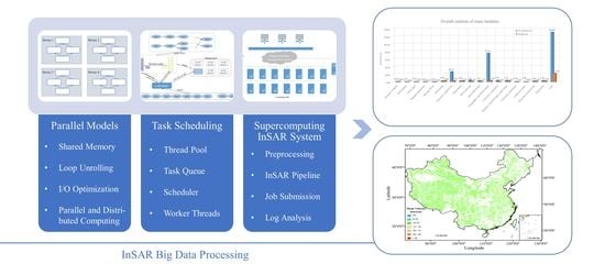
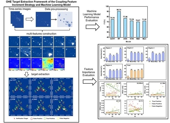
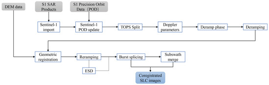
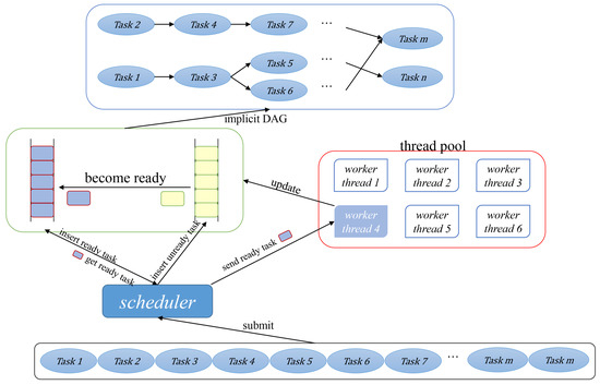
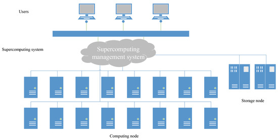
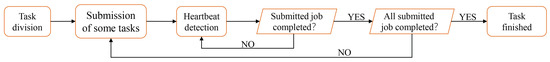
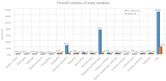
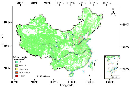
Interferometric synthetic aperture radar (InSAR) has developed rapidly over the past years and is considered as an important method for surface deformation monitoring, benefiting from growing data quantities and improving data quality. However, the handing of SAR big data poses significant challenges for related algorithms and pipeline, particularly in large-scale SAR data processing. In addition, InSAR algorithms are highly complex, and their task dependencies are intricate. There is a lack of efficient optimization models and task scheduling for InSAR pipeline. In this paper, we design parallel time-series InSAR processing models based on multi-thread technology for high efficiency in processing InSAR big data. These models concentrate on parallelizing critical algorithms that have high complexity, with a focus on deconstructing two computationally intensive algorithms through loop unrolling. Our parallel models have shown a significant improvement of 10–20 times in performance. We have also developed a parallel optimization tool, Simultaneous Task Automatic Runtime (STAR), which utilizes a data flow optimization strategy with thread pool technology to address the problem of low CPU utilization resulting from multiple modules and task dependencies in the InSAR processing pipeline. STAR provides a data-driven pipeline and enables concurrent execution of multiple tasks, with greater flexibility to keep the CPU busy and further improve CPU utilization through predetermined task flow. Additionally, a supercomputing-based system has been constructed for processing massive InSAR scientific big data and providing technical support for nationwide surface deformation measurement, in accordance with the framework of time series InSAR data processing. Using this system, we processed InSAR data with the volumes of 500 TB and 700 TB in 5 and 7 days, respectively. Finally we generated two maps of land surface deformation all over China.
Full article
(This article belongs to the Special Issue SAR in Big Data Era II)
▼
Show Figures
Graphical abstract


