Article

Quantification of Environmental Flow Requirements to Support Ecosystem Services of Oasis Areas: A Case Study in Tarim Basin, Northwest China

1
State Key Laboratory of Desert and Oasis Ecology, Xinjiang Institute of Ecology and Geography, Chinese Academy of Sciences, Urumqi 830011, Xinjiang, China
2
Cele National Station of Observation and Research for Desert-Grassland Ecosystems, Qira 848300, Xinjiang, China
3
Key Laboratory of Biogeography and Bioresource in Arid Zone, Chinese Academy of Sciences, Urumqi 830011, Xinjiang, China
4
University of Chinese Academy of Sciences, Beijing 100049, China
5
Key Laboratory of Plant Nutrition and the Agri-Environment in Northwest China, Ministry of Agriculture, Northwest A&F University, Yangling 712100, China
6
College of Mathematics and System Sciences, Xinjiang University, Urumqi 830046, Xinjiang, China
*
Authors to whom correspondence should be addressed.
Water 2015, 7(10), 5657-5675; https://doi.org/10.3390/w7105657
Submission received: 8 June 2015 / Revised: 1 October 2015 / Accepted: 12 October 2015 / Published: 19 October 2015
(This article belongs to the Special Issue Water Resources Assessment and Management in Drylands)

Abstract

:
Recently, a wide range of quantitative research on the identification of environmental flow requirements (EFRs) has been conducted. However, little focus is given to EFRs to maintain multiple ecosystem services in oasis areas. The present study quantifies the EFRs in oasis areas of Tarim Basin, Xinjiang, Northwest China on the basis of three ecosystem services: (1) maintenance of riverine ecosystem health, (2) assurance of the stability of oasis–desert ecotone and riparian (Tugai) forests, and (3) restoration of oasis–desert ecotone groundwater. The identified consumptive and non-consumptive water requirements are used to quantify and determine the EFRs in Qira oasis by employing the summation and compatibility rules (maximum principle). Results indicate that the annual maximum, medium, and minimum EFRs are 0.752 × 10⁸, 0.619 × 10⁸, and 0.516 × 10⁸ m3, respectively, which account for 58.75%, 48.36%, and 40.29% of the natural river runoff. The months between April and October are identified as the most important periods to maintain the EFRs. Moreover, the water requirement for groundwater restoration of the oasis–desert ecotone accounts for a large proportion, representing 48.27%, 42.32%, and 37.03% of the total EFRs at maximum, medium, and minimum levels, respectively. Therefore, to allocate the integrated EFRs, focus should be placed on the water demand of the desert vegetation’s groundwater restoration, which is crucial for maintaining desert vegetation to prevent sandstorms and soil erosion. This work provides a reference to quantify the EFRs of oasis areas in arid regions.

1. Introduction

Water is an extremely crucial natural resource for the socioeconomic sustainable development of arid and semiarid regions worldwide. Oases, being the center of human survival and biodiversity, are a distinctive landscape in arid areas. The existence and stabilization of oases depend on water availability. Recently, the oasis ecosystem has been considered highly vulnerable and is suffering from severe threats because of the scarcity and excessive utilization of water resources [1,2,3]. In particular, the stabilization of the natural oasis ecosystem is seriously threatened under the water-use competition between artificial and natural oasis ecosystems [4]. Xinjiang, Northwest China, as one of the world’s largest arid areas, is characterized by considerably fragile water resources and associated ecological and environmental challenges [5]. Its landscape is a typical mountain-oasis-desert ecosystem, and its oases are situated between the mountainous areas and among the desert plains; these oases are essential for human settlement, preventing desertification, and supporting vegetable cultivation [6,7], hence requiring a stable water supply. In recent years, however, the increase in water demand has been attributed to anthropogenic activities such as agricultural irrigation of artificial oasis areas in the lower reaches of the river basin, thereby increasing the competition for water resources between artificial and natural oasis ecosystems. To resolve the conflict for water resources, the stability and health of natural oasis ecosystems must receive the highest priority to maintain such arid regions [4].
Water demands associated with maintenance of the health of riverine ecosystems have been quantified in previous research through environmental flow requirements (EFRs), which refer to the amount of water needed to restore and maintain the stability and health of ecosystems [8]. Subsequently, several researchers indicated that the EFRs do not only include the water demand of the riverine ecosystem but also that of the eco-environment ecosystem outside the river [9,10,11,12]. Over the next few years, the environmental flows have been classified into consumptive and non-consumptive water requirements, which have been developed to quantify the water demands of various ecosystem functions in wetlands, estuaries, and rivers ecosystem services [13,14,15,16,17,18,19]. In the literature, most studies have estimated the EFRs of natural vegetation or riparian forests in arid areas [6,20]. These findings indicated that water supply is crucial to ensuring ecosystem stabilization in arid areas. However, quantification of the EFRs through the integration of multiple components is lacking in these areas, particularly in the oases of arid areas under multiple ecosystem services. Moreover, few standard methodologies are available for the identification of EFRs in the oases of arid areas because previous works cannot be used in a straightforward manner. This mismatch is ascribed to the differences in ecosystem services and data availability. Notably, the concentration on limited ecosystem functions of rivers, wetlands, or estuaries in ecosystem services leads to oversimplification of EFRs’ identification [17,18]. To fill the gap in EFRs for the oasis in arid areas such as those of Tarim Basin, an appropriate approach should be developed to determine these EFRs.
This paper, on the basis of the characteristics of the oasis ecosystem in Tarim Basin, identifies the EFRs using three functions of the oasis ecosystem services: (1) keeping the riverine ecosystem health to maintain freshwater habitat for biodiversity conservation, sediment transport for riverbed desalting, and salinity balance for salt equilibrium; (2) guaranteeing the stability of the oasis-desert ecotone and riparian forests for combatting desertification and soil erosion; and (3) restoring the groundwater of the oasis-desert ecotone to ensure desert vegetation growth. Notably, water consumption associated with irrigation for farmland ecosystems is not included in the oasis ecosystem services in terms of priority maintenance in the arid region. The Qira oasis case study is conducted to quantify the applicability and practicability of EFRs in the oasis areas of the Tarim Basin in accordance with the summation rule, which is applied to identify consumptive water requirements, as well as the compatibility rule, which is used to determine non-consumptive water requirements [17,18]. The present study first determined the maximum, medium, and minimum levels of EFRs in the Qira oasis and subsequently identified the most important periods for maintaining the EFRs. The proportions for allocation of EFRs in the oasis areas of the Tarim Basin are also discussed. Finally, the allocations of environmental flows and water demands of human activities are presented in this paper.

2. Materials and Methods

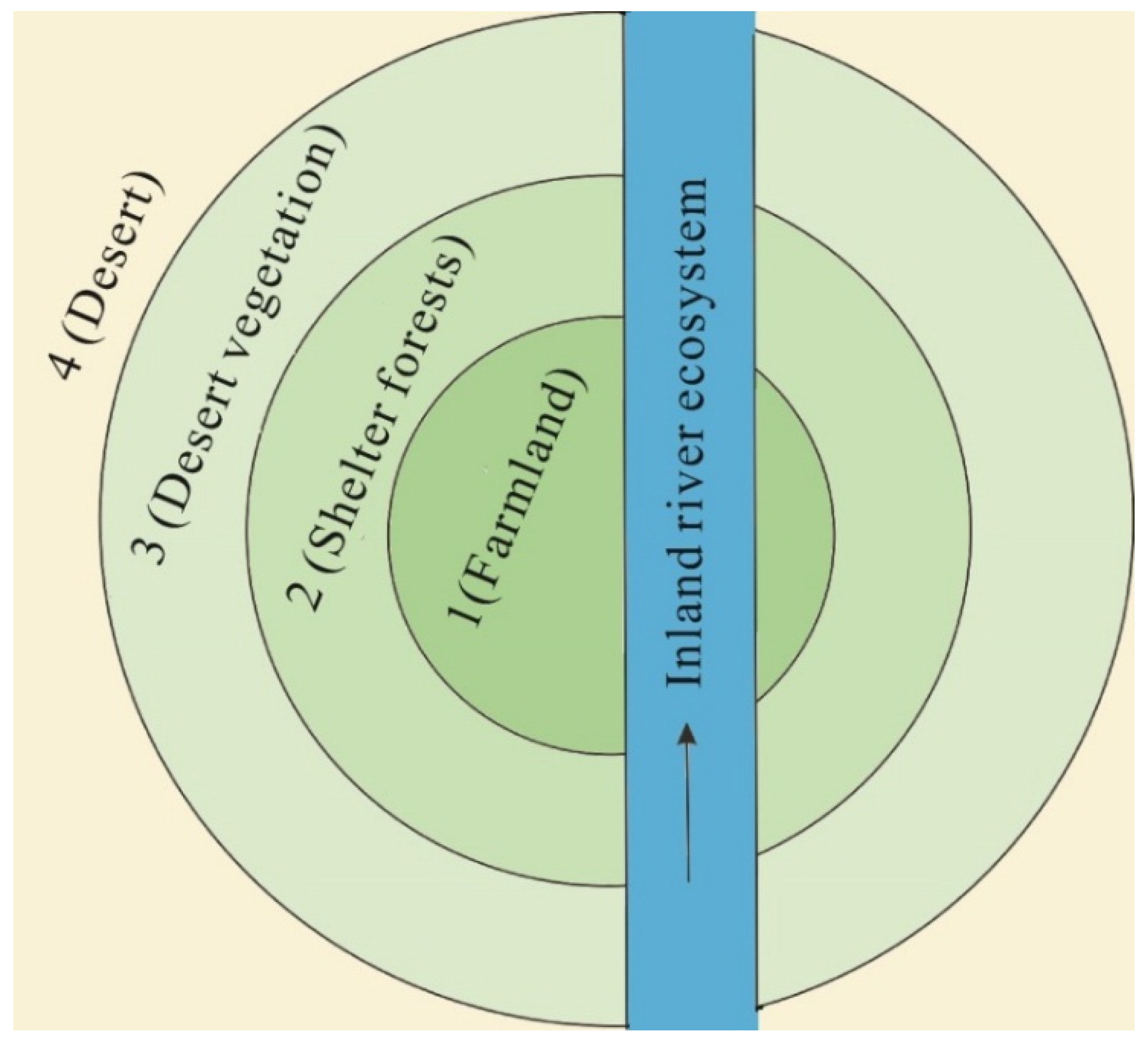
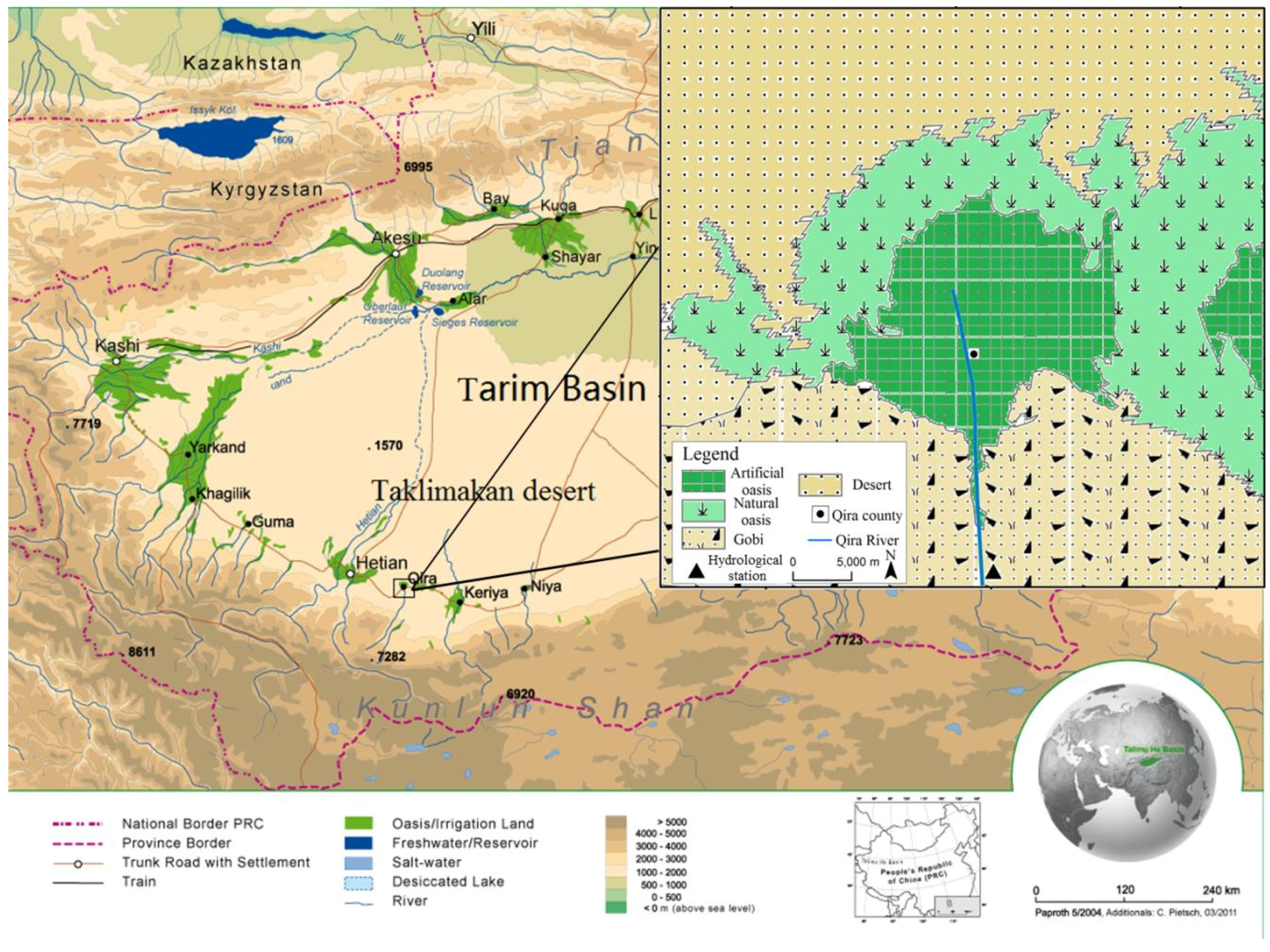
2.1. Study Area and Classification of Environmental Flow Requirements

The Tarim Basin, located in Xinjiang, Northwest China, is the world’s largest inland basin and contains a large number of oases. Owing to the extremely arid climate, with an annual precipitation of below 100 mm and annual potential evaporation of approximately 2000 mm, the water supply in the oasis areas of the Tarim Basin depends only on river water [4,21]. Thus, river discharge is vital for maintaining natural oasis ecosystems (e.g., riparian forests and desert vegetation), as well as artificial oasis ecosystems (e.g., farmland and urban vegetation) in this region. However, with the significant increase of artificial oasis extensions in recent years, several dams have been built in the upstream and/or midstream so that river water can be extracted for anthropogenic activities (e.g., agricultural irrigation). The increase in water demand in such arid areas with severe water deficits has resulted in frequent drying up of the lower reaches of Tarim Basin’s inland rivers. Many serious problems have been exposed, such as vanishing of the aquatic ecosystem, degradation of riparian forests, and decline of the groundwater table. Most importantly, the downstream of the natural oasis ecosystem, which acts as a natural barrier to prevent desertification and sandstorms, has been severely weakened and even nearly lost [4]. These cases are similar to the situations among oases in other arid regions, such as those of Central Asia [22].
On the basis of the ecosystem structures in the oases of arid areas, Abd EI-Ghani [23] divided the Qara oasis of Egypt into three functional belts: desert vegetation belt around the desert region, shelter forest belt around the desert vegetation, and the crop belt at the center. The oasis structures in the Tarim Basin exhibit comparable characteristics. According to the oasis characteristics and ecosystem functions, the oasis space structures in the Tarim Basin are classified into three functional zones, namely, desert, shelter forest, and farmland [24]. However, the riverine ecosystems in the oases of arid areas receive little attention. River discharge serves not only as water supply for human and oasis ecosystem demands but also contributes to the water left in or released into the river channel for aquatic biodiversity and growth of riparian forests. Therefore, inland river ecosystems should also be included in the ecosystem services of oases in arid areas. In the present study, we divide the Tarim Basin oasis’ structure into three circular zones and a strip (Figure 1). From the center, the first circular zone represents the farmland ecosystem, the second represents the shelter forest, and the third represents the desert vegetation ecosystem; the strip represents the inland river ecosystem.
Figure 1. Schematic map of ecosystem functions in the oasis areas of Tarim Basin.
Water 07 05657 g001
The water supply that is solely dependent on river water must meet multiple functions of ecosystem services in the oasis areas of the Tarim Basin. From the aforementioned classification, the riverine ecosystem and the natural oasis ecosystem are regarded as two ecosystem services in the region, whereas the artificial oasis ecosystem controlled by human activities is not considered as one of the ecosystem services among the maintenance priorities in such arid regions [25]. Therefore, given the different ecosystem functions, EFRs in oasis areas of the Tarim Basin are classified into various components (Table 1). Four types of components are identified, including water demands for river health, desert vegetation growth, maintenance of riparian and shelter forests, and groundwater restoration. These water requirements must ensure the integrity of ecosystem functions, including water quantity (e.g., maintenance of riverine habitat and desert vegetation) and water quality (e.g., salinity balance and nutrient transport).
Furthermore, on the basis of water consumption characteristics, the EFRs in the oasis areas of the Tarim Basin are classified into non-consumptive and consumptive water demands. Water volumes for ensuring the replacement of evapotranspiration by desert vegetation, riparian and shelter forests, groundwater restoration, and water losses of river channel are identified as consumptive EFRs. By contrast, water volumes for maintaining the riverine habitat and providing adequate transport of sediments and nutrients are considered as non-consumptive EFRs. Non-consumptive water requirements ensure the maintenance of river health and flow, as well as prevent drying up of the oasis areas in the Tarim Basin.
Table 1. Classification of environmental flow requirements (EFRs) in the oasis areas of Tarim Basin.
Ecosystem TypeEnvironmental Flow RequirementsEcosystem Functions
Riverine ecosystemEFRs for riverine ecosystem healthMaintenance of riverine habitat
Sediment transport
Salinity balance
Nutrients transport
Nature oasis ecosystemEFR for maintenance of desert vegetationCombating desertification
EFRs for maintenance of riparian and shelter forestsPreventing sandstorm
EFR for groundwater restorationEnsuring desert vegetation growth

2.2. Quantification of Environmental Flow Requirements in Oasis Areas of Tarim Basin

According to the classification of oasis ecosystem services above, water demands for the riverine ecosystem, desert vegetation ecosystem, and riparian and shelter forests ecosystem are considered prior to agricultural water conversion. At higher elevations before the mountain pass, the river is recharged by groundwater. In the downstream plain oasis of the Tarim Basin, little groundwater recharge or return flow occurs because the riverbed is higher than the surrounding land [4]. Groundwater of the oasis areas comes from overbank flow of river water. Therefore, the water supply in the oasis areas of Tarim Basin solely depends on river discharge, which originates from the glacier or snow melt and precipitation of Kunlun mountain ranges in the South, Tianshan mountain ranges in the North, and Pamir mountain ranges in the West. The discharge then flows through the oasis areas and finally discharges into the extremely arid desert. The water requirements of different components in the EFRs demonstrate spatial difference. The health of riverine, riparian, and shelter forest ecosystems (mainly Populus euphratica) is maintained by perennially uninterrupted discharge. The desert vegetation ecosystem (mainly shrub vegetation) preventing desertification and soil erosion is fed by the seasonal flooding period (recruiting more shrubs and grassland) and groundwater (ensuring that the shrubs do not wither). Notably, the EFRs between desert vegetation and groundwater restoration do not overlap. The groundwater depth in the oasis areas can only support deep-rooted desert vegetation that does not wither throughout the year from surface water shortage. Desert vegetation (short-root plants and weeds) are fed by river discharge and can also recruit new shrubs and plants in the seasonal flooding period. The water requirements of EFRs’ components exhibit spatial and temporal differences. However, in the present study, these water requirements are simply quantified using an annual average scale based on the previous literature. The water requirements (e.g., desert vegetation) are basically synchronous with river runoff variation on temporal scales [26]. Therefore, the temporal allocation for the EFRs is based on the proportion of natural river runoff on different temporal scales. Consequently, the EFRs’ components are quantified in the oasis areas of the Tarim Basin as follows.

2.2.1. Environmental Flow Requirement for Base Flows

The environmental flow requirement for base flows is minimum river discharge, which is used to maintain the health of aquatic habitats, improve the self-purification ability and integrity of riverine ecosystem, and ensure continuous flows. In the current study, EFRs for base flows are determined by the annual average of minimum monthly river runoff during a period of little human disturbance [18]:
W b f = 1 n i = 1 n m i n ( Q i j )
where Wbf is the EFR for river base flows (m3), Qij is the jth monthly river runoff at the ith year (m3), and n is the number of years. The runoff data (Q) resulted is obtained from the hydrological station, which presents a long-term daily mean runoff time series during 1960–2010 for hydrological studies upstream of the oasis areas of Tarim Basin.

2.2.2. Environmental Flow Requirement for Sediment Transport

Water demand for sediment transport requires that river discharge is applied to maintain the dynamic equilibrium of scour and erosion of river sediment transport. Therefore, EFRs for sediment transport are determined by the carrying capacity and quantity of sediment in the oasis areas of Tarim Basin. The expression is given as follows [17,18,19]:
W s t = S t / C t
where Wst refers to the EFR for sediment transport (m3), St is the quantity of sediment in inland rivers of the oasis areas (kg), and Ct denotes the sediment carrying capacity (kg/m3). Both St and Ct are determined from long-term records of sediment transport data at the hydrological station upstream of oasis areas of Tarim Basin.
Moreover, salinity balance and nutrient transport exert certain effects on the riverine ecosystem. Generally, the EFR for maintaining sediment transport can meet the requirement of water quality in inland rivers of arid areas [16]. Therefore, the water quality of riverine ecosystem is not discussed hereafter.

2.2.3. Environmental Flow Requirements for Evaporation of Surface Water

To maintain river water flow, the evaporation of surface water in the river channel should be considered. The EFR for water evaporation in the river channel in arid areas is calculated as follows [27]:
W e = ε l b E 0
where We is EFR for the evaporation of surface water of river channel (m3); ε is reduction coefficient of evaporation; l and b are length and width of river channel, respectively; and E0 is the annual evaporation based on records of an evaporating dish with a 20 cm diameter.

2.2.4. Environmental Flow Requirements for Different Vegetation Types

Water requirements for different vegetation types (i.e., riparian and shelter forests and desert vegetation) are crucial for wind prevention and sand resistance. The EFRs for plant communities represent the summation of all water demands [27,28,29]. The formula is expressed as follows:
W f = i = 1 2 S i R i
where Wf is the EFRs for riparian and shelter forests, as well as desert vegetation (m3); Si is the area of the ith vegetation types (km2); Ri is the ecological water quota of ith vegetation types estimated via evapotranspiration results using lysimeter method (m3/km2). In 2003, Wang et al. [28] estimated the ecological water quotas for high-, medium-, and low-coverage grass to be 2343.8, 1486.7, and 629.7 m3/hm2, respectively, and that for riparian and shelter forests to be 3405 m3/hm2 in the oasis areas of Tarim Basin.

2.2.5. Environmental Flow Requirements for Groundwater Restoration

Water requirements for groundwater restoration are water volumes restoring to the target water table to maintain desert vegetation growth. Therefore, EFRs for groundwater restoration are calculated as follows [27]:
W g r = M Δ H S n
where Wgr is the EFR for groundwater restoration (m3); M is the saturation deficiency of the zone of fluctuation of the water table (cm3/g). Song et al. [27] estimated the saturation deficiency of the fluctuation belt of water table (M) to be 0.16 (cm3/g), given the aquifer saturation rate of 25.8%; ΔH is the change in height of ground water (m); S is the area of desert vegetation cover (km2); and n is the bulk density of soil (g/cm3), which is determined as 1.36 (g/cm3) by n = 35.72e−0.185H (H is the groundwater depth).

2.2.6. Integration of Environmental Flow Requirements for Various Ecosystem Functions

According to the classification of consumptive and non-consumptive water requirements, the rule of summation is used to obtain consumptive EFRs, whereas the rule of maximum is applied to calculate non-consumptive ones. Therefore, EFRs in the oasis areas of Tarim Basin are integrated by the following expression:
W = W e + W f + W g r + m a x ( W b f , W s t )
where W is the total environmental flow requirement in the oasis areas of Tarim Basin (m3), and max (a, b) refers to the maximum value of parameters a and b.

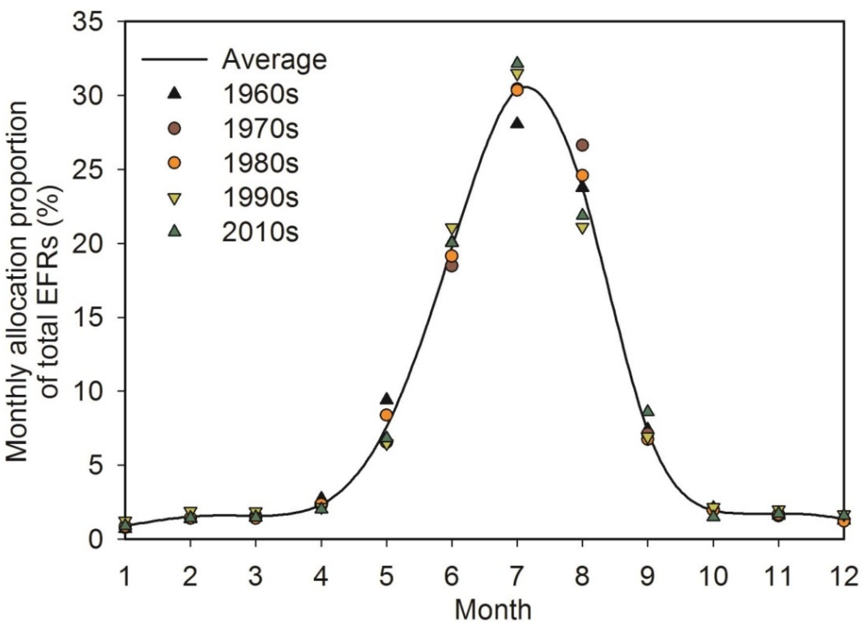
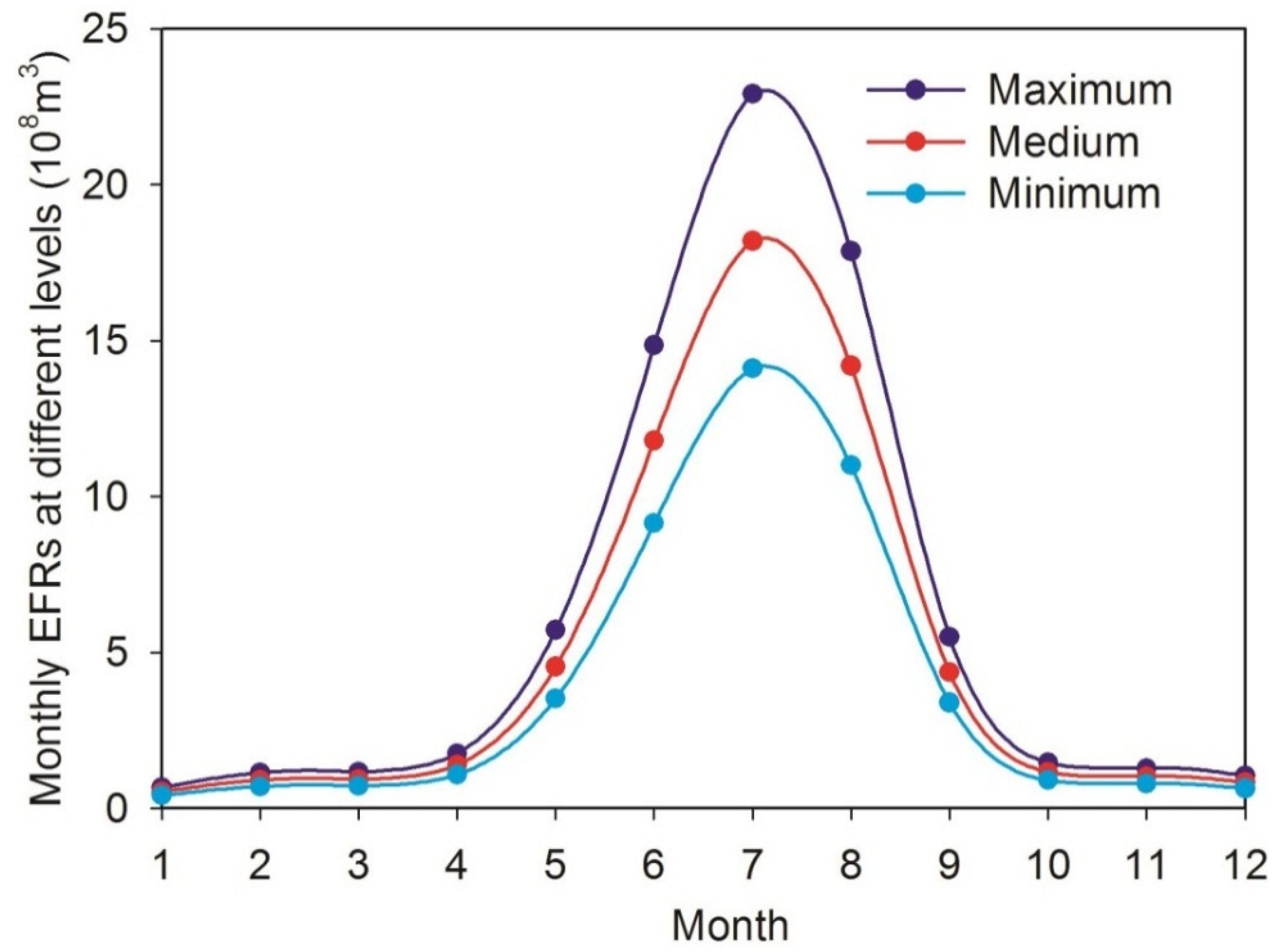
2.2.7. Temporal Allocation of Environmental Flow Requirements

EFRs generally show temporal variability at different scales (e.g., annual and monthly scales), but the water supply for EFRs (the river discharge) is easily influenced by anthropogenic activities (e.g., extensive irrigation or water diversion project). Consequently, the water requirements for multiple ecosystem services cannot be satisfied by the natural oasis areas of Tarim Basin. To maintain the stability and health of riverine and natural oasis ecosystems, allocation of temporal EFRs should be considered under the temporal variability of natural river discharge.
To ensure a natural flow regime in the oasis of Tarim Basin, the temporal pattern of natural river runoff is considered as the indicator of the temporal variability of EFRs. Therefore, EFRs are allocated on the basis of the proportion of natural river runoff at different temporal scales. The allocation proportion of EFRs is expressed as follows:
P i = j = 1 n Q j i / j = 1 n Q j
where Pi is the proportion of the monthly river runoff in ith month to the annual runoff during 1960–2010, Qji is the river runoff in ith month of jth year (m3) from 1960 to 2010, and Qj is the annual runoff in jth year (m3) from 1960 to 2010.

2.3. Case Study Illustrating the Application of Environmental Flow Requirements in Qira Oasis

Oases in the Tarim Basin present similar structures and characteristics. Hence, in this research, the Qira oasis located in the south rim of Tarim Basin in Xinjiang is selected for the case study of EFRs by virtue of the available data. The Qira oasis lies in the lower reaches of the Qira River Basin (latitudes 36°54′ N–37°09′ N and longitudes 80°37′E–80°59′E) (Figure 2). Its existence mainly depends on the availability of Qira River, which is generated from the high altitude valley of Kunlun Mountains, then flows through the Qira oases, and finally discharges into the extremely arid desert. Given an annual precipitation of approximately 39 mm and a strong evaporation of 2700 mm which is estimated by the measured data of a 20 cm diameter evaporating dish during 1960–2010, the water supply in the Qira oasis area solely depends on river discharge [30,31,32]. On the basis of the meteorological data (Qira station) in the Qira oasis and the hydrological data obtained by a hydrological station 19.5 km from the Qira county (Figure 2), the annual mean temperature, annual evaporation, and precipitation increased during the period of 1960–2010 by rates of 0.28 °C/10a, 90.98 mm/10a, and 17.20 mm/10a, respectively. By contrast, the annual runoff declined from 1960 to 2010 by a rate of −0.03 × 10⁸ m3/10a (Figure 3). Although the climate of Xinjiang has begun to transform from warm and dry conditions to warm and wet conditions [2,33], the decrease of runoff caused by regional climate change (less rainfall and strong evaporation) leads to more pressure being placed on integrated water resource management for eco-environmental protection and economic sustainable development in the Qira oasis.
The Qira oasis consists of four types of ecosystems, i.e., desert vegetation ecosystem, shelter forest ecosystem, farmland ecosystem, and riverine ecosystem. The farmland ecosystem is controlled by human activities and, hence, not included within the ecosystem services under maintenance priority in the region. With regard to the desert vegetation ecosystem, the remote sensing data from Landsat™ imagery in 2010 are compiled to obtain desert vegetation coverage in the Qira oasis. On the basis of the TM spectral characteristics, the classification maps of land cover are assessed with the scale of 1:47,000, and the classification accuracy is determined using the Kappa coefficient [34]. According to the classification results, desert vegetation in the Qira oasis is composed of high-coverage grass (69.34 km2) (60%–90% vegetation coverage), medium-coverage grass (22.54 km2) (20%–60% vegetation coverage), and low-coverage grass (20.28 km2) (5%–20% vegetation coverage). From the evaluation of classification precision, the Kappa coefficients of classification data in 2010 was found to account for 93%. Therefore, these classification data can reflect the changes of land cover in the study region with relative high accuracy [34]. The riparian and shelter forests (mainly Populus euphratica) in the Qira oasis accounted for 50 km2, which comprises 30.86% of the total coverage areas (Table 2). Considering the uncertainty in compiling and classifying the desert vegetation, the actual area of each type grass is quantified by classifying three levels (i.e., maximum, medium, and minimum), respectively [19]. According to water requirement quota estimated by the results from the experiment [28], the water demand for each type of grass is determined by the water requirement quota multiplied by the corresponding actual area. Moreover, at upstream of the Qira oasis, long-term records of runoff and sediment discharge from 1960 to 2010 are available in the Qira hydrological station (1557 m above sea level).
Table 2. Vegetation types, vegetation cover indices, and areas occupied by different vegetation types. Maximum, medium, and minimum denote three levels of water demands by vegetation.
Vegetation TypeVegetation Cover IndexTotal Area (km2)Area (km2)
MaximumMedium Minimum
Desert vegetationHigh-coverage grass (60% to 90%)69.3462.4152.0141.60
Medium-coverage grass (20% to 60%)22.5413.529.024.51
Low-coverage grass (5% to 20%)20.284.062.541.01
Riparian and shelter forests50505050
Total162.16129.99113.5697.13
Figure 2. Location and topography of the study area, adapted from the project SuMaRiO [35].
Water 07 05657 g002
Figure 3. Variations in annual precipitation and evaporation (a); annual mean temperature, and annual runoff (b) in the Qira oasis.
Water 07 05657 g003

3. Results and Discussion

3.1. Quantification of Environmental Flow Requirements

According to different ecosystem functions of the riverine ecosystem in the Qira oasis area, the EFRs for base flows, sediment transport, and water evaporation of river channel are calculated using Equations (1)–(3), respectively. Considering there was little human disturbance during the period from 1960 to 1979, the riverine eco-environment maintained its natural state in the absence of the establishment of water conservation measures and severe utilization of river water in the Qira oasis area. Therefore, the EFRs for base flows are determined on the basis of the average of annual minimum monthly river runoff between 1960 and 1979. The EFR of base flow is estimated to be 0.016 × 10⁸ m3, which accounts for 1.25% of natural river discharge. For sediment transport, the quantity of sediment in Qira oasis area is 1,810,000 kg, and the sediment carrying capacity is 13.5 kg/m3. As a result, the EFR for sediment transport is determined to be 0.014 × 10⁸ m3, which represents 1.09% of total river discharge. Moreover, river length and river width are 115 km and 23.88 m, respectively, and annual evaporation and reduction coefficient of evaporation are 2505 mm and 0.5, respectively. Therefore, the EFR for water evaporation of river channel is calculated to be 0.034 × 10⁸ m3, which accounts for 2.66% of total river discharge. The results imply that the EFR for water evaporation of the river channel has the largest water demand, which represents 53.10% of the EFRs for all ecological functions in the riverine ecosystem. The conclusions are different from the observations on the EFRs in wetlands and estuaries, in which maintaining the sediment transport and salinity balance requires higher EFRs than other components [16,17,19]. The contrasting results are attributed to very strong evaporation (approximately 2700 mm) and small runoff (3.9 m3·s−3) in the Qira oasis area, so that the EFR for water evaporation of river channel is greater than that for base flow and sediment transport.
The EFRs for different ecosystem functions of the natural oasis ecosystem (including desert vegetation and riparian and shelter forests) in the Qira oasis area are calculated using Equation (4). Given that desert vegetation in the Qira oasis consists of high-, medium-, and low-coverage grass, based on corresponding water quota, the EFRs for desert vegetation are estimated to be 0.169 × 10⁸, 0.137 × 10⁸, and 0.105 × 10⁸ m3 at the maximum, medium, and minimum levels, respectively. Moreover, the EFRs of riparian and shelter forests (mainly comprised Populus euphratica) are calculated to be 0.170 × 10⁸ m3, which accounts for a larger proportion than that of desert vegetation (Table 3). According to Zhang (2003) [36], the stability of desert vegetation and riparian and shelter forests mainly depended on groundwater depth. The most suitable groundwater depth for desert vegetation and forests is approximately 4–7 m. When the groundwater depth is greater than 7 m, desert vegetation and forests begin to degenerate [36]. Given the severe water utilization in the upstream of the Qira oasis, groundwater depth has reached 8.45 m. Based on those estimated groundwater tables, the EFR for groundwater restoration is calculated using Equation (5). The maximum (groundwater depth restored to 4 m), medium (groundwater depth restored to 6 m) and minimum (groundwater depth restored to 7 m) water requirements are 0.363 × 10⁸, 0.262 × 10⁸, and 0.191 × 10⁸ m3, respectively. The EFRs of the components (including desert vegetation, riparian and shelter forests, and groundwater restoration) are found to require large water supply in the natural oasis ecosystem of the Qira oasis area [37]. Particularly, the EFRs for groundwater restoration are considerably higher than other water demand components in the natural oasis ecosystem. In fact, with the Qira oasis comprising the most important ecosystem services, satisfying the EFRs has become crucial for combating desertification and soil erosion in the Qira oasis and other oasis areas of Tarim Basin.
Through classification of non-consumptive and consumptive water volumes, the total EFRs in the Qira oasis area are determined using Equation (6). The EFRs at the maximum, medium, and minimum levels are determined to be 0.752 × 10⁸, 0.619 × 10⁸ and 0.516 × 10⁸ m3, respectively, which respectively account for 58.75%, 48.36%, and 40.29% of the total river discharge. The calculated water volumes are essential to maintain the stability and health of the Qira oasis ecosystem. Moreover, the temporal pattern of the total EFRs at the different time scales in the Qira oasis area is calculated using Equation (7). The ecological objective for ecosystem services is determined by the monthly proportion of the total EFRs during 1960–2010 in the Qira oasis. The monthly allocation proportion of the total EFRs from April to October represents the most important periods to maintain the EFRs in the Qira oasis (Figure 4).
The river discharge during this period ensures greater than 93% of the total EFRs. The allocation of the EFRs between October and April of the subsequent year is very low at different levels, whereas that between April and October has become crucial to support the water demands of multiple ecosystem services in the Qira oasis (Figure 5). In previous studies, the EFRs are classified by consumptive and non-consumptive water demand to meet various ecosystem functions in river, wetland, or estuary ecosystem services [16,18,19]. Under multiple ecosystem services, the EFRs in the oasis areas of Tarim Basin are also divided into consumptive water (including EFRs for groundwater restoration, riparian and shelter forests, desert vegetation, and evaporation of surface water) and non-consumptive water (including EFRs for base flows and sediment transport). Maintaining the total EFRs in the Qira oasis area requires >50% of the natural river flows at the maximum level. The results are consistent with the data obtained from wetlands or estuaries [16,19]. Moreover, at a monthly scale, the allocation of the EFRs is concentrated mainly on the flooding period, which is the crucial time for supporting and recruiting the desert vegetation and forests in oasis–desert ecotone [38]. Therefore, ensuring the river discharge at temporal scale performs a key function to maintain the stability and health of natural oasis ecosystems.
Table 3. Environmental flow requirements for natural oasis ecosystem based on different ecosystem functions.
Ecological FunctionsWater Quota (m3/hm2) Maximum (108 m3)Medium (108 m3)Minimum (108 m3)
High-coverage grass2343.80.1460.1220.098
Medium-coverage grass1486.70.0200.0130.007
Low-coverage grass629.70.0030.0020.001
Riparian and shelter forests34050.1700.1700.170
Total0.3390.3070.276
Figure 4. Proportion of temporal allocation for the total EFRs during different periods in Qira oasis.
Water 07 05657 g004
Figure 5. Monthly EFRs for multiple ecosystem functions at different levels (Maximum, Medium, and Minimum) in Qira oasis.
Water 07 05657 g005

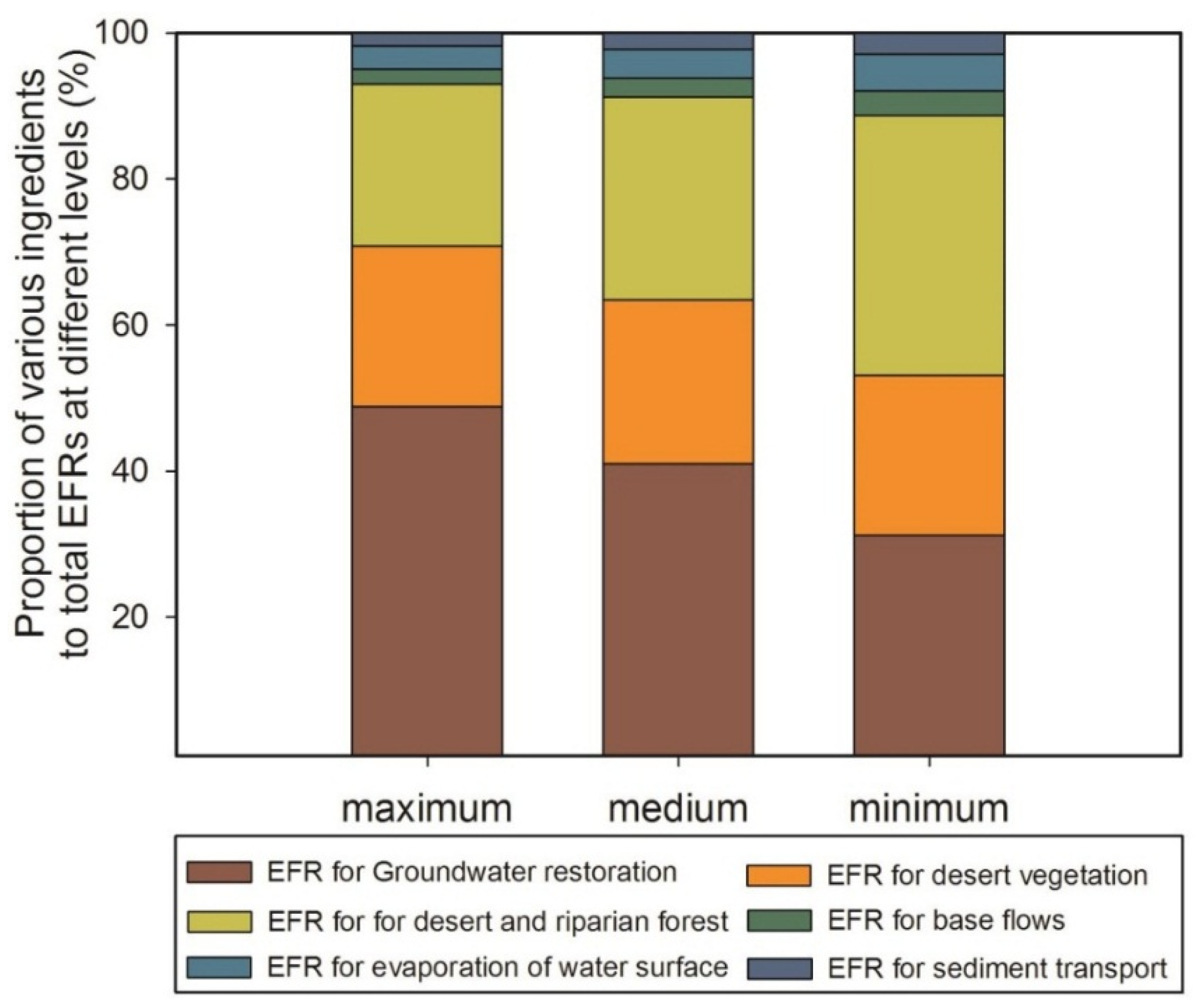
3.2. Proportion of Environmental Flow Requirements for Multiple Ecosystem Functions

The EFRs of various ingredients for multiple ecosystem services require different water demands in oasis areas. According to classification in Table 2, three levels of each component are calculated by corresponding equation (Table 3), and the proportion of each EFR at different levels is determined by water demand of each component dividing by total EFRs. In non-consumptive water, EFRs for base flows and sediment transport at the maximum level represent 2.09% and 1.83% of the total EFRs, respectively (Figure 6). Similarly, the EFRs for sediment transport are higher than those for base flows at the medium and minimum levels, implying that the EFR for sediment transport is sufficient to satisfy the water requirement for base flows.
For consumptive water systems, the riparian and shelter forests, desert vegetation, and groundwater restoration require more water volumes at the maximum level and account for 22.19%, 22.06%, and 47.39% of the total environmental flow requirements, respectively (Figure 6). Among the consumptive water systems, the environmental flow requirements for groundwater restoration of oasis–desert ecotone comprise the largest proportion, which account for 48.27%, 42.32%, and 37.03% of the total environmental flow requirements at the maximum, medium, and minimum levels, respectively.
According to the above EFR analysis, the proportion of the EFR of each ingredient in natural oasis ecosystem is larger than that in the riverine ecosystem. In extremely arid areas, the EFRs for natural oasis ecosystem undoubtedly account for a larger proportion [6]. Moreover, in all components of the EFRs, the EFR for groundwater restoration requires the greatest water supply. In the past few years, groundwater depth in the oasis areas of Tarim Basin has rapidly declined because of the increase in water demand for human activities (particularly agricultural irrigation) [38], thereby increasing pressure for groundwater restoration in the oasis area. Groundwater, once depleted, is very difficult to restore [39]. Therefore, in future research, more focus should be given to groundwater management in the Qira oasis and other oasis areas of Tarim Basin.
Figure 6. Proportion of various ingredients to the total EFRs for multiple ecosystem functions at different levels (Maximum, Medium, and Minimum) in Qira oasis.
Water 07 05657 g006

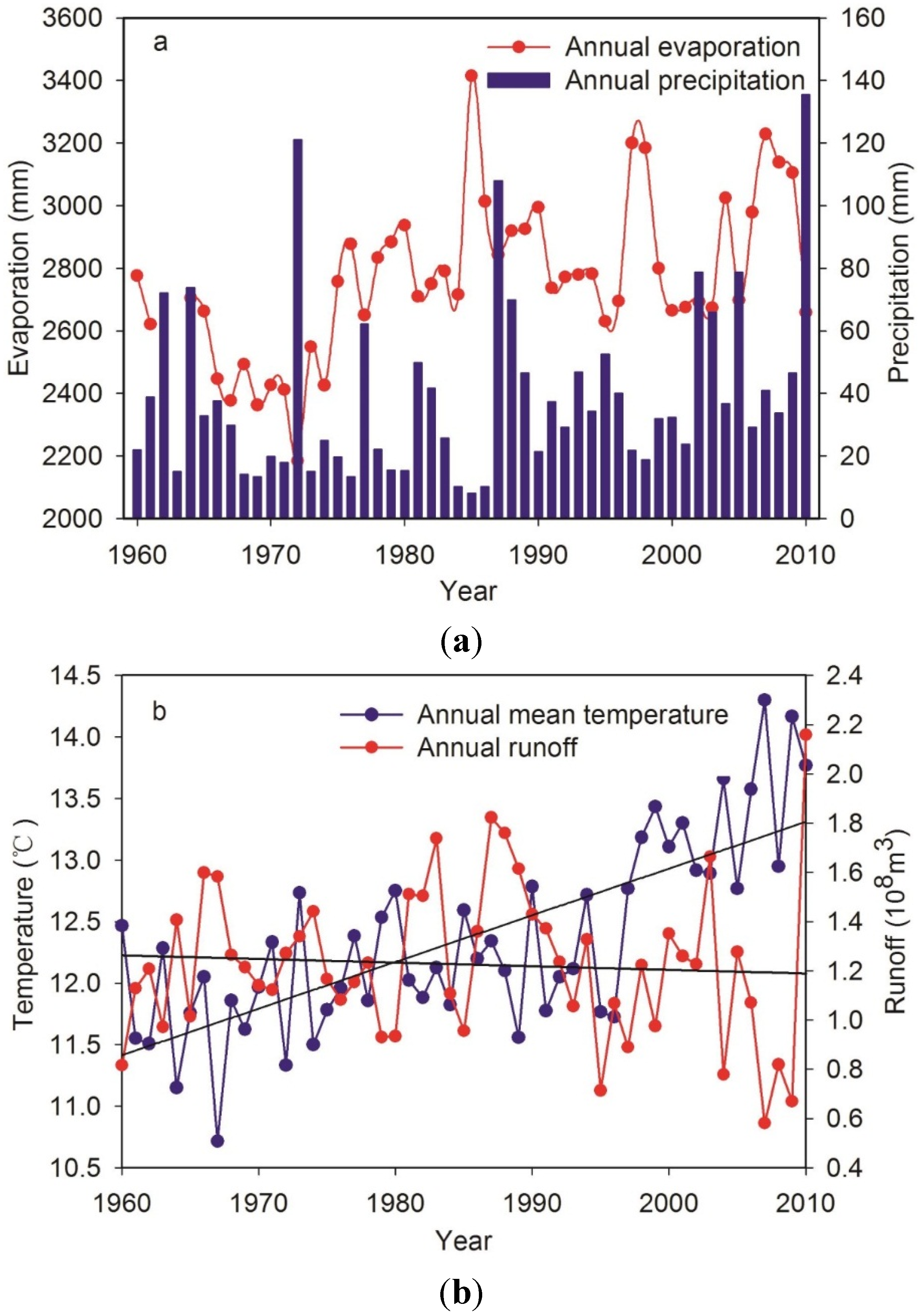
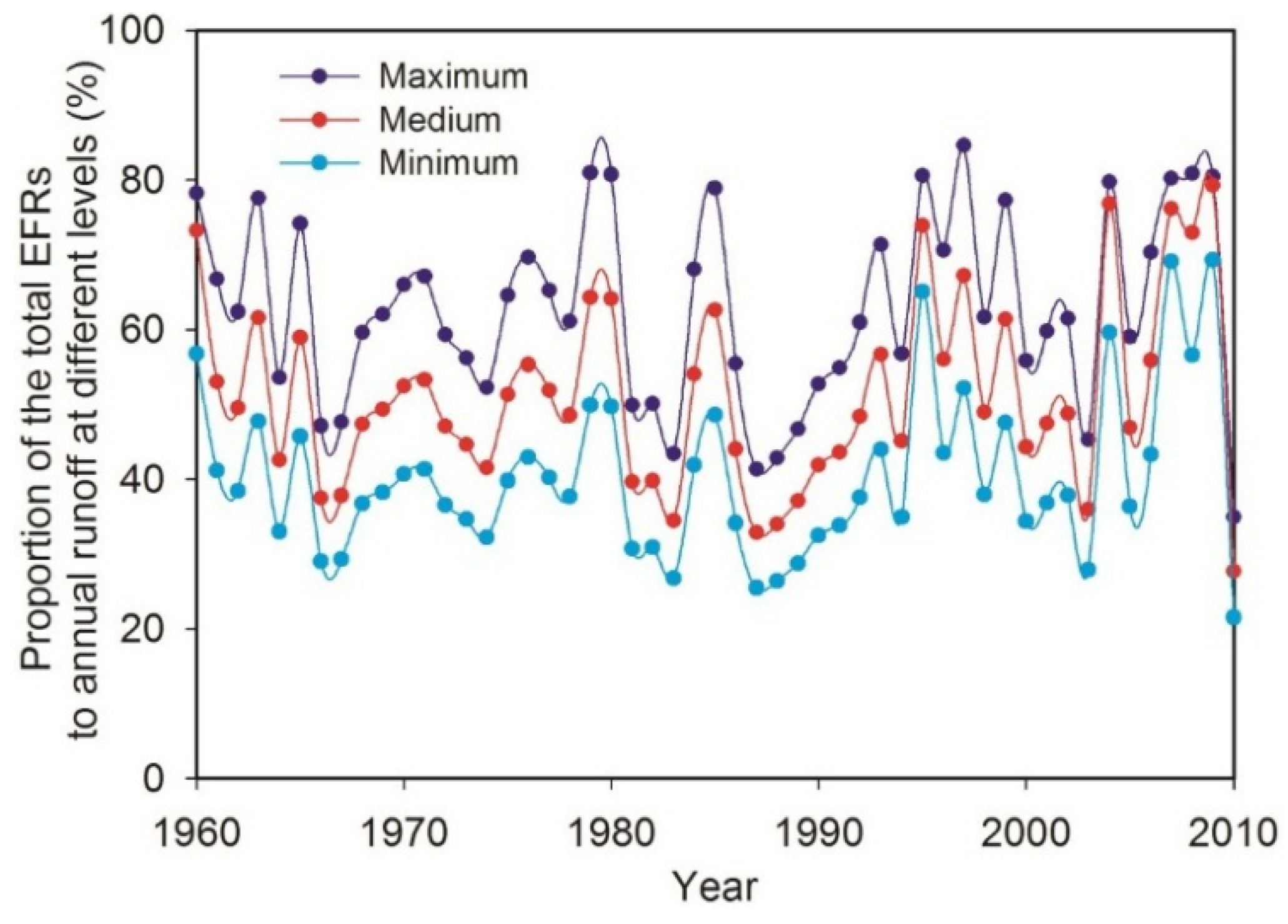
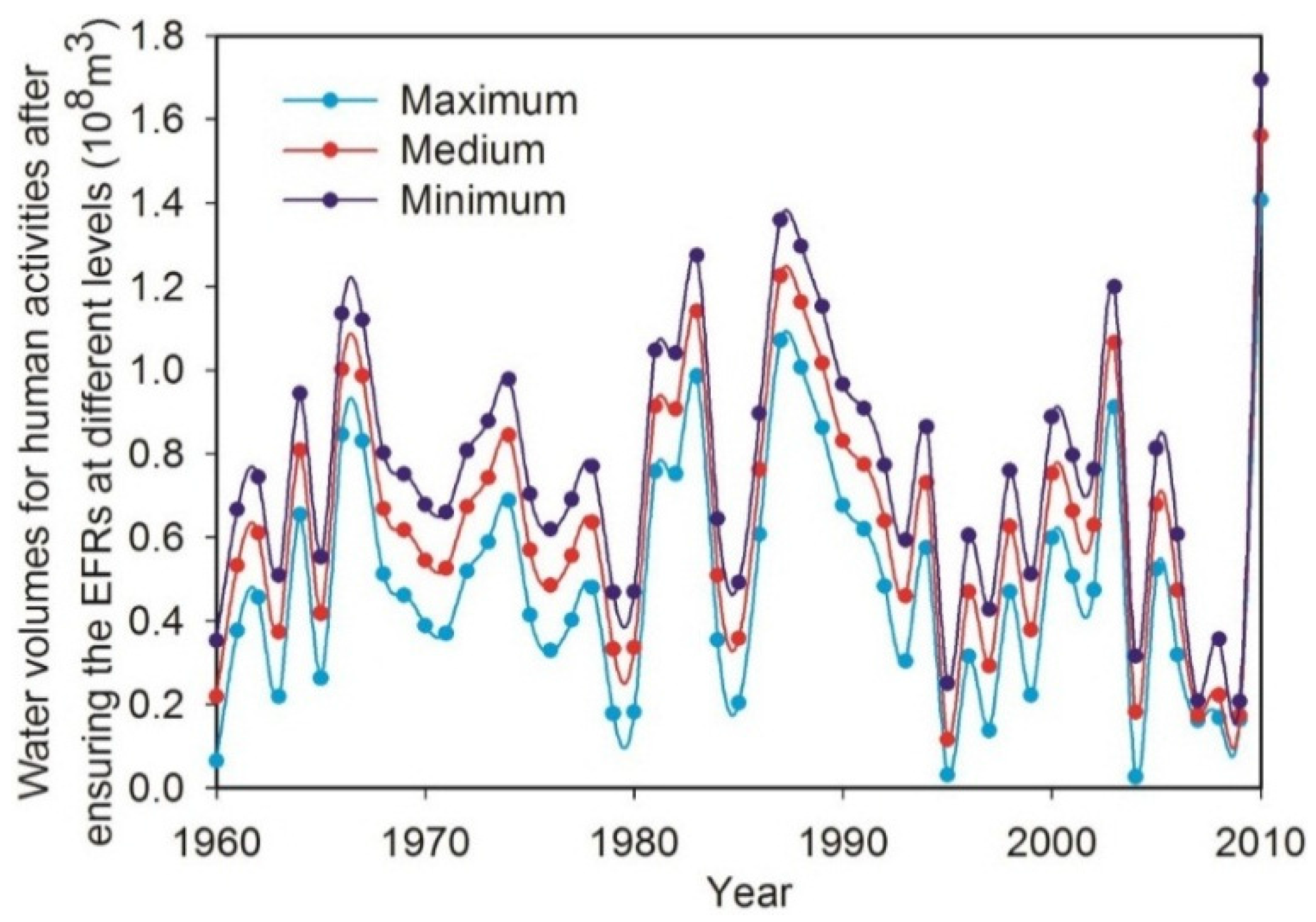
3.3. Response of Environmental Flow Requirements to Natural River Runoff

Figure 7 illustrates the proportion of annual total EFR to annual river discharge from 1960 to 2010 in the Qira oasis. The natural river runoff can almost satisfy EFRs at the maximum levels in dry years, such as in 1995, 2007, and 2009. Given that the river runoff started to change abruptly and remarkably and then decreased in 1994, the proportion of annual total EFR to annual river discharge in the pattern of the graph changes more considerably. Thus, a major challenge is to meet water requirements for both human activities and natural ecosystems in the time allocation, especially during dry years.
In the Qira oasis, water used for anthropogenic activities, especially agricultural irrigation, is mainly extracted from river discharge. Therefore, considering the EFRs with priority, a water volume that meets the demands of the EFRs is crucial to support human activities. Figure 8 indicates the annual water volume to ensure EFRs in the Qira oasis from 1960 to 2010, i.e., the water volume for annual runoff subtracting the total EFRs. The water volumes are essential to satisfy the water demands in socioeconomic sustainable developments. The annual average water volumes available for human activities are respectively determined to be 0.765 × 10⁸, 0.662 × 10⁸, and 0.529 × 10⁸ m3 at the maximum, medium, and minimum levels while ensuring EFRs are met in the Qira oasis. Meeting the EFR requirements has been a recommendation for water use of an artificial oasis (such as farmland) in water resource management.
In previous studies, the EFRs for multiple ecosystem services are proposed with higher priority in river, wetland, or estuary ecosystem studies to coordinate the conflicting water demands between ecosystem services and socioeconomic sustainable developments [16,17,18,19]. Similarly, particular focus in the Qira oasis and other oasis areas of Tarim Basin should be placed on the EFRs, preferentially on the basis of different ecosystem services. However, approximately 95% of water resources extracted from river and groundwater is used for anthropogenic activities, especially agricultural irrigation [4]. Thus, the water demands for human activities and the natural oasis ecosystem in Qira and other oasis areas of Tarim Basin leads to competition for water extracted from river discharge. Considering the severe water utilization through human activities such as agricultural irrigation, the oasis–desert ecotone has recently experienced a substantial shrink and is frequently eroded by windblown sand in Qira and other oasis areas of Tarim Basin [37].
Consensus action on supplying water for human activities while ensuring EFRs has been achieved [40,41,42,43]. However, prioritizing EFRs probably results in economic losses in oasis farmlands owing to shortages in the water used for irrigation in such extremely arid regions. Water trade-off between human activities and eco-environmental requirements can pose greater challenges in Qira and other oasis areas of Tarim Basin, particularly during dry periods. Under such circumstances, economic compensation may be an effective measure to relieve conflicts between supply and demand [44,45,46]. Therefore, to ensure that the EFRs of natural oasis ecosystems are met, optimal allocation of water resources of artificial oasis and integrated water resource management should be a focus.
Figure 7. Proportion of the total EFRs to annual runoff at different levels (Maximum, Medium, and Minimum) in Qira oasis.
Water 07 05657 g007
Figure 8. Water volumes needed to support human activities after ensuring the EFRs at different levels in Qira oasis.
Water 07 05657 g008

4. Conclusions

This study identifies and quantifies the EFRs to support the three ecosystem services in the Qira oases of Tarim Basin in accordance with the summation and compatibility rules (maximum principle). The results indicate that EFRs for supporting various ecosystem services are 0.752 × 10⁸, 0.619 × 10⁸, and 0.516 × 10⁸ m3 at the annual maximum, medium, and minimum levels, which account for 58.57%, 48.36%, and 40.29% of the natural river runoff in the Qira oasis, respectively. The results imply that natural river discharge, which should be discharged within the Qira oasis, should provide at least the abovementioned water volumes to ensure the stability and health of oasis ecosystems in the Qira oasis. The months spanning from April to October are identified as the most crucial periods to maintain the EFRs. River discharge during this period ensures more than 93% of the annual total EFRs.
In the integrated environmental flow allocation, the EFR for groundwater restoration of the oasis–desert ecotone comprises the largest proportion, which accounts for 48.27%, 42.32%, and 37.03% of the total EFRs at the maximum, medium, and minimum levels, respectively. Therefore, more focus should be given to the water demands of groundwater restoration of desert vegetation, which is vital to preventing desertification and occurrence of sandstorms. Annual water volumes available for human activities to satisfy EFRs in the Qira oasis are 0.765 × 10⁸, 0.662 × 10⁸, and 0.529 × 10⁸ m3 at the maximum, medium, and minimum levels, respectively. EFRs serve as the foundation for socioeconomic sustainable developments to meet the water demands of ecosystem services.
Although this work quantifies the EFRs by considering multiple ecosystem services in oasis areas; however, estimation of the EFRs related to data uncertainty (such as error of coverage area classification in TM image compilation) and methodological drawbacks (e.g., error of empirical parameters in the equation) may result in a large uncertainty. In future research, focus will be given to parameter calibration with experimental data and uncertainty analysis to quantify the EFRs in the oasis areas.

Acknowledgments

This work was financially supported by the National Natural Science Foundation of China (41471031), the Thousand Youth Talents Plan Project (Y472241001), and the project of Science and Technology Service Network Initiative (STS) of Chinese Academy of Sciences. The authors would like to acknowledge two anonymous reviewers for their valuable comments on the paper.

Author Contributions

All authors contributed to the design and development of this manuscript. Jie Xue carried out the data analysis and prepared the first draft of the manuscript; Jiaqiang Lei, Dongwei Gui and Ying Zhao are the graduate advisor of Jie Xue and contributed many ideas to the study; Xinlong Feng, Fanjiang Zeng, Jie Zhou, and Donglei Mao provided some important advices on the concept of methodology and writing of the manuscript.

Conflicts of Interest

The authors declare no conflict of interest.

References

  1. Boehmer, K.; Memon, A.; Mitchell, B. Towards sustainable water management in Southeast Asia—Experiences from Indonesia and Malaysia. Water Int. 2000, 25, 356–377. [Google Scholar] [CrossRef]
  2. Chen, Y.N.; Xu, Z.X. Plausible impact of global climate change on water resources in Tarim River Basin. Sci. China Ser. D 2005, 48, 65–73. [Google Scholar] [CrossRef]
  3. Ling, H.B.; Zhang, Q.Q.; Xu, H.L.; Shi, W. Regional climate change and its effects on the runoff of Manas River, Xinjiang, China. Environ. Earth Sci. 2011, 64, 2203–2213. [Google Scholar] [CrossRef]
  4. Rumbaur, C.; Thevs, N.; Disse, M.; Ahlheim, M.; Brieden, A.; Cyffka, B.; Duethmann, D.; Feike, T.; Fror, O.; Gartner, P.; et al. Sustainable management of river oases along the Tarim River (SuMaRiO) in Northwest China under conditions of climate change. Earth Syst. Dynam. 2015, 6, 83–107. [Google Scholar] [CrossRef]
  5. Chen, Y.N. Water Resources Research in Northwest China; Springer: Berlin, Germany, 2014; pp. 3–18. [Google Scholar]
  6. Ye, Z.X.; Chen, Y.N.; Li, W.H. Ecological water demand of natural vegetation in the lower Tarim River. J. Geogr. Sci. 2010, 20, 261–272. [Google Scholar] [CrossRef]
  7. Ling, H.B.; Xu, H.L.; Fu, J.Y.; Fan, Z.L.; Xu, X.W. Suitable oasis scale in a typical continental river basin in an arid region of China: A case study of the Manas River Basin. Quatern. Int. 2013, 286, 116–125. [Google Scholar] [CrossRef]
  8. Covich, A. Water and Eeosystems; Oxford University Press: NewYork, NY, USA, 1993; pp. 40–52. [Google Scholar]
  9. Petts, G.E. Water allocation to protect river ecosystems. Regul. Rivers Res. Manag. 1998, 12, 353–365. [Google Scholar] [CrossRef]
  10. Prat, N.S.; Munné, A. Water use and quality and stream flow in a Mediterranean stream. Water Res. 2000, 34, 3876–3881. [Google Scholar] [CrossRef]
  11. Richter, B.D.; Mathews, R.; Harrison, D.L.; Wigington, R. Ecologically sustainable water management: Managing river flows for ecological integrity. Ecol. Appl. 2003, 13, 206–224. [Google Scholar] [CrossRef]
  12. Cai, X.; Rosegrant, M.W. Optional water development strategies for the Yellow River Bas in: Balancing agricultural and ecological water demands. Water Resour. Res. 2004, 40, W08S04. [Google Scholar]
  13. Flannery, M.S.; Peebles, E.B.; Montgomery, R.T. A percent-of-flow approach for managing reductions of freshwater inflows from unimpounded rivers to the southwest Florida Estuaries. Estuaries 2002, 25, 1318–1332. [Google Scholar] [CrossRef]
  14. Tharme, R.E. A global perspective on environmental flow assessment emerging trends in the development and application of environmental flow methodologies for rivers. River Res. Appl. 2003, 19, 397–441. [Google Scholar] [CrossRef]
  15. Benetti, A.D.; Lanna, A.E.; Cobaichini, M.S. Current practices for establishing environmental flows in Brazil. River Res. Appl. 2004, 20, 427–444. [Google Scholar] [CrossRef]
  16. Yang, Z.F.; Sun, T.; Qin, X.S. Calculating methods for quantifying environmental flows in estuaries: A case study of Haihe River Basin, China. J. Environ. Inf. 2005, 6, 72–79. [Google Scholar] [CrossRef]
  17. Sun, T.; Yang, Z.F.; Cui, B.S. Critical environmental flows to support integrated ecological objectives for the Yellow River Estuary, China. Water Resour. Manag. 2008, 22, 973–989. [Google Scholar] [CrossRef]
  18. Yang, Z.F.; Sun, T.; Cui, B.S.; Chen, B.; Chen, G.Q. Environmental flow requirements for integrated water resources allocation in the Yellow River Basin, China. Commun. Nonlinear Sci. 2009, 14, 2469–2481. [Google Scholar] [CrossRef]
  19. Sun, T.; Yang, Z.F.; Shen, Z.Y.; Zhao, R. Ecological water requirements for the source region of China’s Yangtze River under a range of ecological management objectives. Water Int. 2012, 37, 236–252. [Google Scholar] [CrossRef]
  20. Thomas, F.M.; Foetzki, A.; Arndt, S.K.; Bruelheide, H.; Gries, D.; Li, X.; Runge, M. Water use by perennial plants in the transition zone between river oasis and desert in NW China. Basic Appl. Ecol. 2006, 7, 253–267. [Google Scholar] [CrossRef]
  21. Tang, Q.C.; Chen, H.Y. Water resources and oasis construction in Tarim Basin. Chin. Geogra. Sci. 1992, 2, 173–182. [Google Scholar] [CrossRef]
  22. CAWA. Regional Research Network-Central Asian Water. Available online: http://www.cawa-project.net/ (accessed on 5 March 2015).
  23. Abd EI-Ghani, M.M. Flora and vegetation of Gara oasis, Egypt. Phytocoenol 1992, 21, 1–14. [Google Scholar]
  24. Hu, S.J.; Song, Y.D.; Tian, C.Y.; Li, Y.T.; Li, X.C.; Chen, X.B. Suitable scale of Weigan River plain oasis. Sci. China Ser. D 2007, 50, 56–64. [Google Scholar] [CrossRef]
  25. Malano, H.M.; Davidson, B.A. Framework for assessing the trade-off between economic and environmental uses of water in a river basin. Irrig. Drain. 2009, 58, 133–147. [Google Scholar] [CrossRef]
  26. Wang, F.; Liang, R.L.; Yang, X.L.; Chen, M.J. A study of ecological water requirements in northwest China: Theoretical analysis. J. Nat. Resour. 2002, 17, 1–8. (in Chinese). [Google Scholar]
  27. Song, Y.D.; Fan, Z.L.; Lei, Z.D.; Zhang, F.W. Research On Water Resources And Ecology Of Tarim River, China; Volksverlag Xinjiang: Urumqi, China, 2000; pp. 400–406. [Google Scholar]
  28. Wang, R.H.; Lu, X.M.; Song, Y.D.; Fan, Z.L.; Ma, Y.J. Patterns and characteristics of ecological water demand in west arid zone of China—A case study of green corridor in the lower reaches of Tarim River. Chin. J. Appl. Ecol. 2003, 14, 520–524. (in Chinese). [Google Scholar]
  29. Fan, Z.L.; Ma, Y.J.; Zhang, H.; Wang, R.H.; Zhao, Y.J.; Zhou, H.F. Research of eco-water table and rational depth of groundwater of Tarim river Drainage Basin. Arid Land Geogr. 2004, 27, 8–13. (in Chinese). [Google Scholar]
  30. Liu, B.; Zhao, W.Z.; Chang, X.X.; Li, S.B.; Zhang, Z.H.; Du, M.W. Water requirements and stability of oasis ecosystem in arid region, China. Environ. Earth Sci. 2010, 59, 1235–1244. [Google Scholar] [CrossRef]
  31. Wu, J.L.; Yang, F.X.; Zhou, J.; Zhang, Z.W. Desert types and characteristics in the Qira River Basin. Arid Land Geogr. 2013, 36, 803–811. (in Chinese). [Google Scholar]
  32. Wu, Y.W.; Yang, F.X.; Hua, T. Landforms and their effects on ecological pattern in the Qira River Basin. Arid Zone Res. 2011, 28, 355–362. (in Chinese). [Google Scholar]
  33. Shi, Y.F.; Shen, Y.P.; Kang, E.S.; Li, D.L.; Ding, Y.J.; Zhang, G.W.; Hu, R.J. Recent and future climate change in Northwest China. Clim. Chang. 2007, 80, 379–393. [Google Scholar] [CrossRef]
  34. Congalton, R.G.; Green, K. Assessing the Accuracy of Remotely Sensed Data: Principals and Practices; CRC Press: London, UK, 1999; pp. 137–145. [Google Scholar]
  35. The project SuMaRiO. Sustainable Management of River Oases Along the Tarim River. Available online: http://www.sumario.de/ (accessed on 15 March 2015).
  36. Zhang, F. Water Resource Variation and Its Effects on landscape changes Research in Qira Oasis; Xinjiang University: Urumqi, China, 2003. [Google Scholar]
  37. Bruelheide, H.; Jandt, U.; Gries, D.; Thomas, F.M.; Foetzki, A.; Buerkert, A.; Wang, G.; Zhang, X.M.; Runge, M. Vegetation changes in a river oasis on the southern rim of the Taklamakan Desert in China between 1956 and 2000. Phytocoenologia 2003, 33, 801–818. [Google Scholar] [CrossRef]
  38. Chen, Y.N.; Li, W.H.; Xu, H.L.; Liu, J.Z.; Zhang, H.F.; Chen, Y.P. The influence of groundwater on vegetation in the lower reaches of Tarim River, China. Acta Geogr. Sin. 2003, 58, 542–549. [Google Scholar]
  39. Cui, Y.L.; Shao, J.L. The role of ground water in arid/semiarid ecosystems, Northwest China. Groundwater 2005, 43, 471–477. [Google Scholar] [CrossRef] [PubMed]
  40. Andrea, F.; Acreman, M.; Dunbar, M.J. Defining environmental river flow requirements: A review. Hydrol. Earth Syst. Sci. 2004, 8, 861–876. [Google Scholar]
  41. Yates, D.N.; Sieber, J.; Purkey, D.; Huber, A. WEAP21—A demand-, priority-, and preference-driven water planning model part 1: Model characteristics. Water Int. 2005, 30, 487–500. [Google Scholar] [CrossRef]
  42. Wei, Y.P.; Davidson, B.; Chen, D.L.; White, R.E. Balancing the economic, social and environmental dimensions of agro-ecosystems: An integrated modeling approach. Agr. Ecosyst. Environ. 2009, 131, 263–273. [Google Scholar] [CrossRef]
  43. Pang, A.P.; Sun, T.; Yang, Z.F. A framework for determining recommended environmental flows for balancing agricultural and ecosystem water demands. Hydrol. Sci. J. 2014, 59, 890–903. [Google Scholar] [CrossRef]
  44. Ran, B.Q.; Xu, F.R.; Zhang, C.L. Review of research and practice of river basin ecological compensation. J. Hydraul. Eng. 2008, 39, 1220–1225. [Google Scholar]
  45. Liu, Y.L.; Hu, P. Ecological compensation standard for Xinjiang River basin based on Pareto optimization. J. Hydraul. Eng. 2009, 40, 703–713. [Google Scholar]
  46. Sisto, N.P. Environmental flows for rivers and economic compensation for irrigators. J. Environ. Manag. 2009, 90, 1236–1240. [Google Scholar] [CrossRef] [PubMed]

