1. Introduction
The Sendai Framework for disaster risk reduction [
1] and the Sustainable Development Goals [
2] recommend that more efforts should be made to carry out risk analysis with a holistic vision. This should orient a new generation of plans and projects towards communities that are most at risk, towards the main hydroclimatic threats, and should help monitoring, evaluation, communication [
3], and awareness-raising activities [
4]. In this article, with the term “risk”, we mean “the combination of the probability of an event and its negative consequence” [
5]. In the Global South, the multihazard approach is increasingly included in risk reduction plans [
6] and in publications addressing risk on a local [
7,
8,
9,
10,
11,
12,
13] and regional [
14,
15,
16,
17,
18] scale. Nevertheless, the cases in which this approach has been used up to now reveal the difficulty of applying multihazard risk assessment methods and techniques that have been fine-tuned for countries boasting all the information and local expertise necessary [
19,
20,
21,
22,
23] to areas that lack these characteristics. West Africa is a typical case. In this vast region, widespread warming, an increase in both the intensity and frequency of extreme heat waves, and heavy precipitation events [
24,
25,
26,
27,
28,
29] were combined with an increase in the number of hydroclimatic disasters [
30] during the 1990–2010 period. The impact was catastrophic, considering the region’s high reliance on rain-fed agriculture [
31] and transhumant pastoralism. In the six years that followed, international aid earmarked
$7.3 billion for creating 715 climate change (CC) adaptation projects in West Africa’s 17 countries [
32]. These projects mainly operate on a local scale (districts and municipalities) and function alongside those that each individual country is already implementing with its own resources. Despite the fact that the terms “climate adaptation” and “resilience” constantly appear in these projects, the definition and location of actions cannot yet take advantage of either climate analysis, risk mapping [
33], or disaster databases on a regional scale [
34]. For example, subnational risk mapping lacks detail [
35,
36,
37,
38] and is mainly limited to floods. Multihazard risk is rarely taken into consideration. Risk is calculated using indicators that do not represent risk factors. The techniques involved are still too complex to be used at a local level or reproduced over time and space [
39,
40,
41,
42,
43,
44,
45,
46,
47,
48,
49,
50,
51,
52,
53] (
Table 1).
The goal of this article is to propose a multihazard risk assessment on a regional scale that will be useful during decision-making processes and that can be updated over time by personnel lacking advanced skills.
The achievement of this goal raises issues concerning (i) the characterization of hydroclimatic threats at regional level, (ii) the representation of the risk level according to administrative jurisdictions, (iii) the pertinence of risk reduction policies to climatic threats, and (iv) the setting up of the assessment in such a way that it can be repeated.
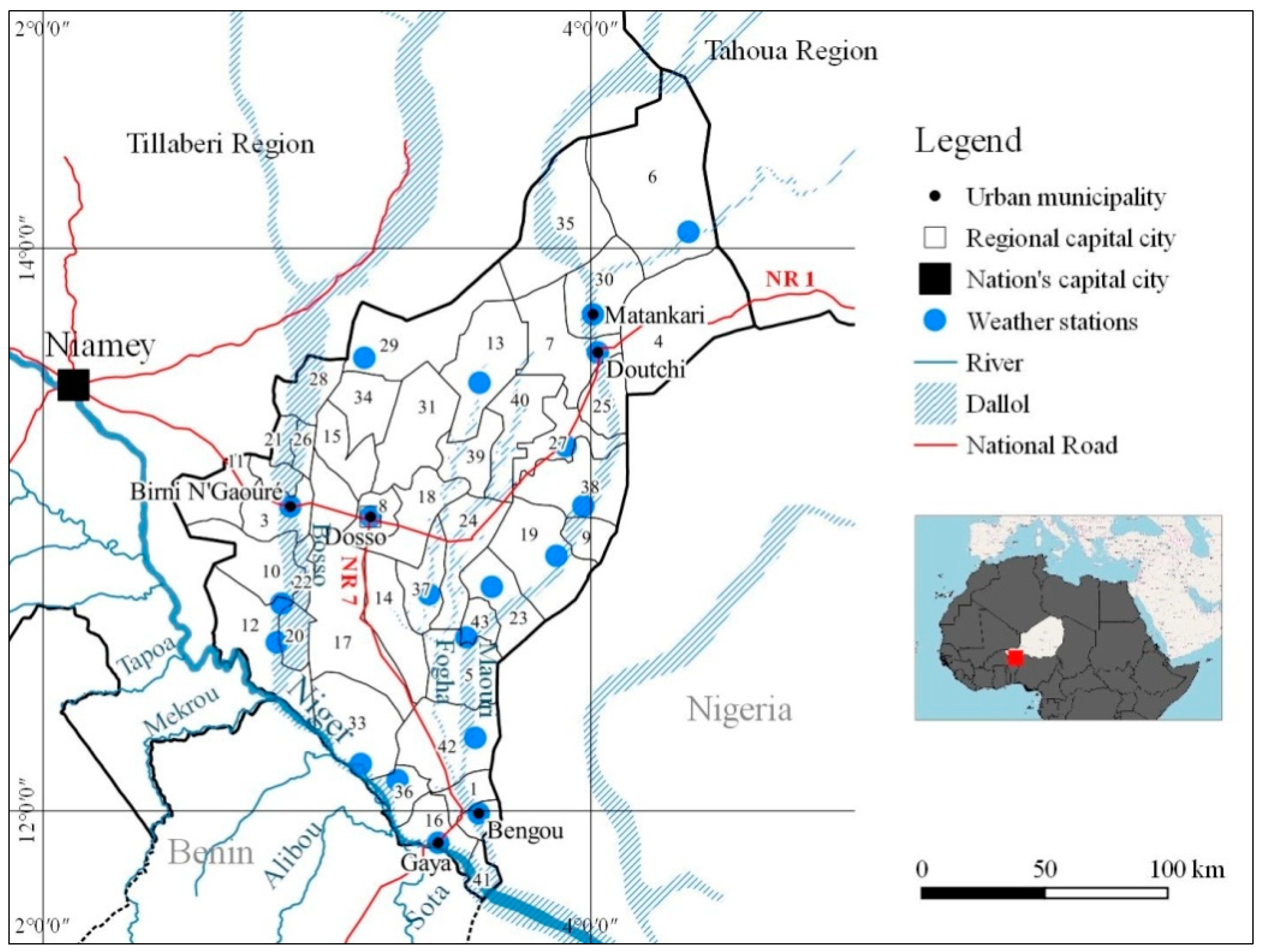
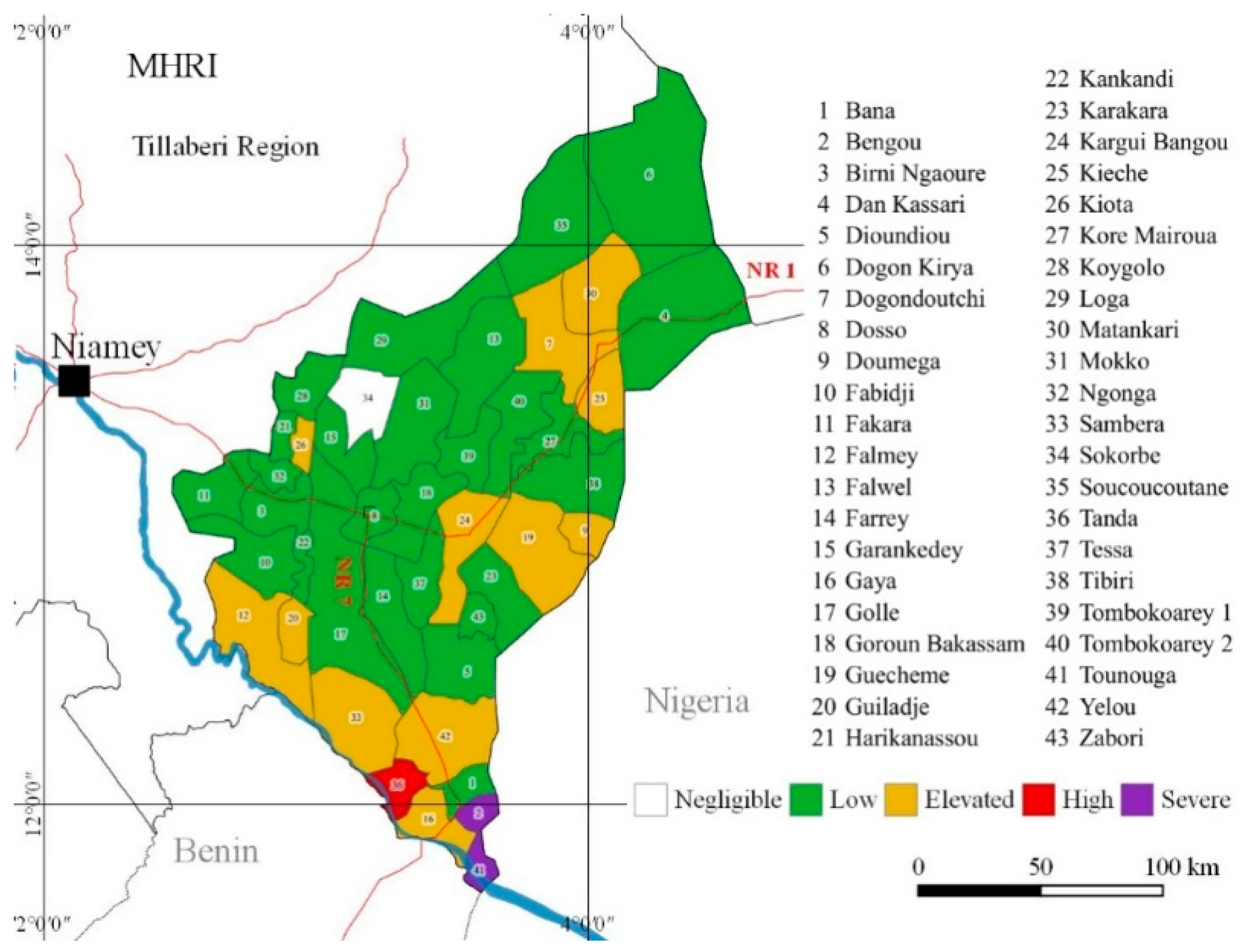
The assessment was carried out in the Dosso region (31,000 km
2, with a population of 2 million) of Niger (
Figure 1), the region most hit by flooding [
53] in the West African country with the highest hydroclimatic risk [
54].
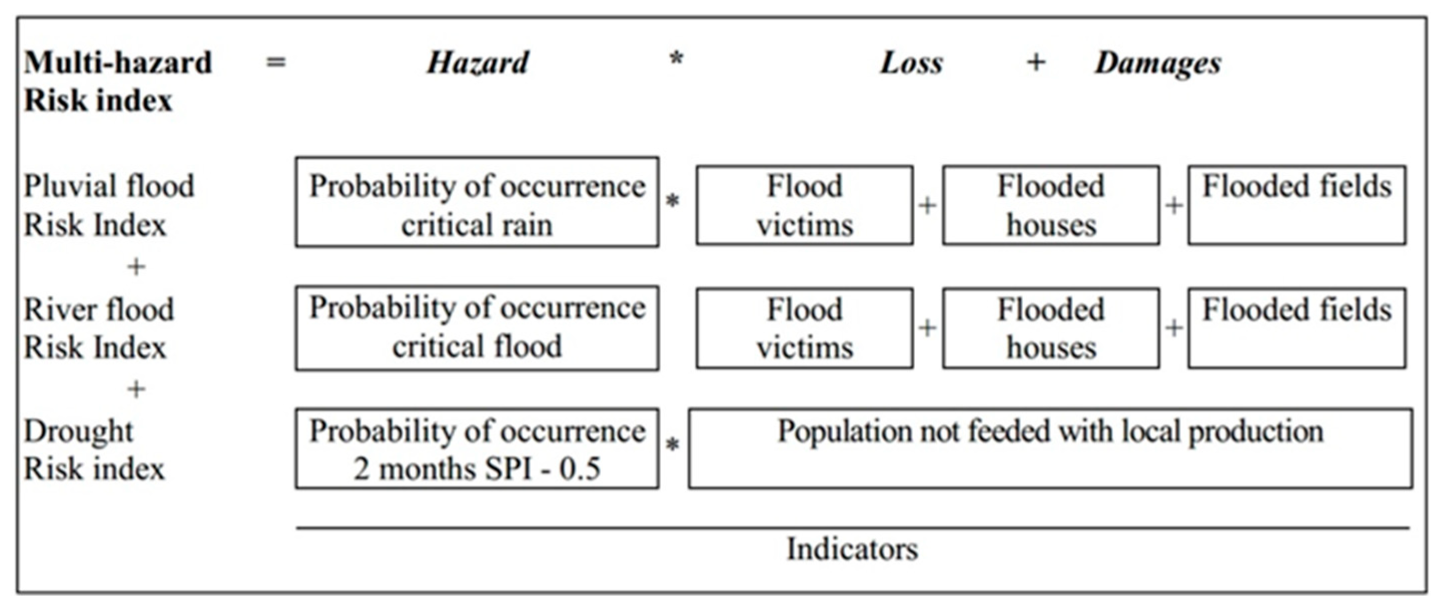
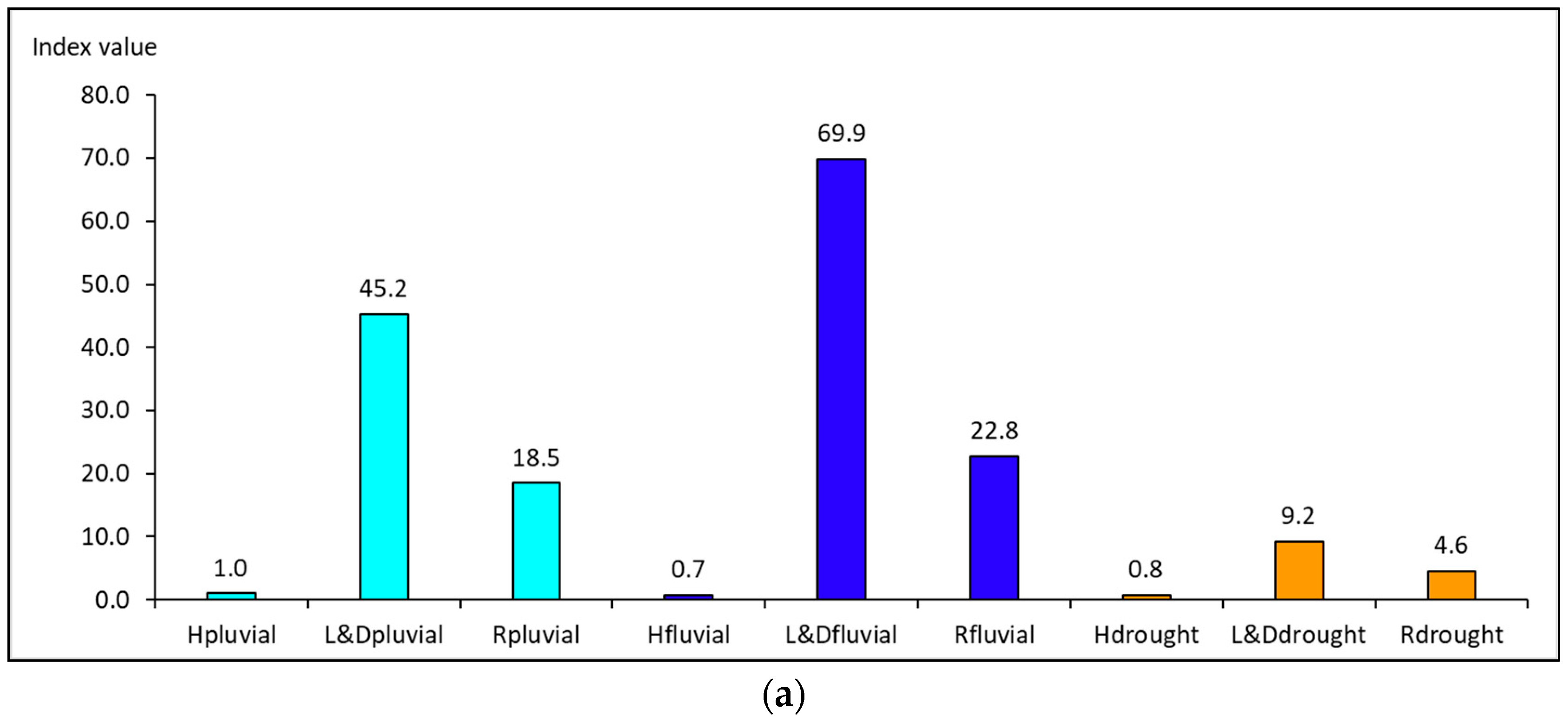
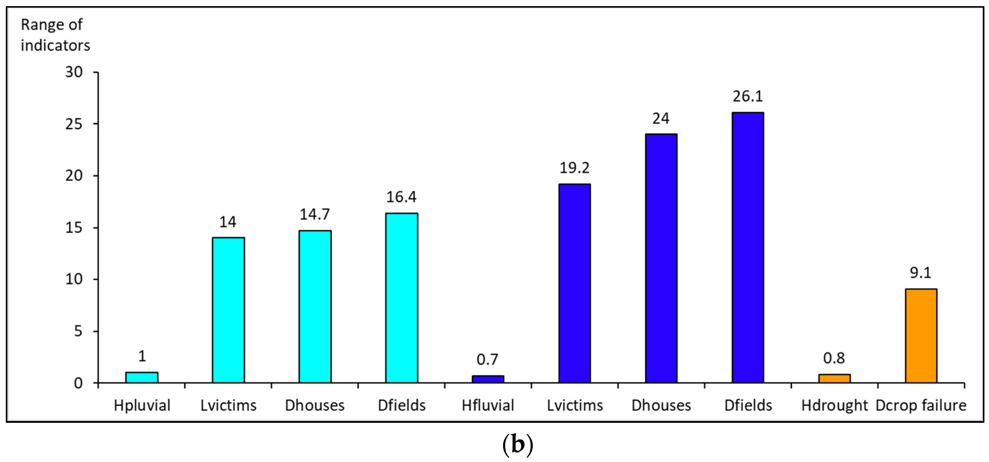
The assessment considers pluvial flooding, fluvial flooding, and meteorological drought because other climatic hazards affecting Dosso (such as heat waves) are not systematically recorded at a municipal level. The three risks are then combined in a multihazard risk index (MHRI) with respect to the consistency of the period of time observed, the occurrence probability (1981–2017), the weight of risk determinants, the range of risk classes, the minimal unit of analysis (municipality), and the indicator measure (quantitative) [
55].
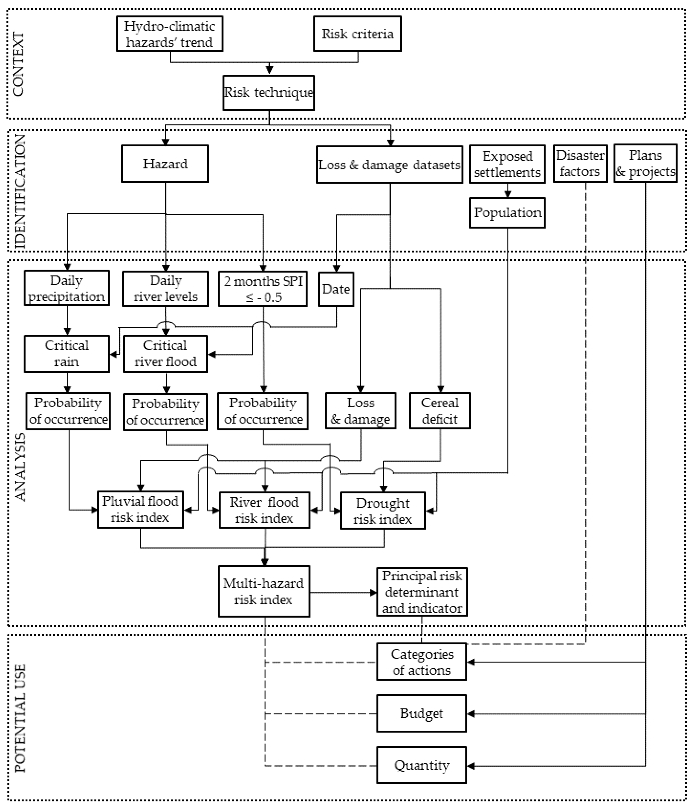
The assessment is divided into four steps [
56] (
Figure 2).
The first step involves the context. Extreme rainfall events increased during the 1950–2014 period [
57] in Niger. The aim is to ascertain the recent trend in hydroclimatic hazards regarding each individual municipality compared to the previous 30-year period. The information was provided by the Directorate National for Meteorology (with the French acronym DMN) from a rainfall estimate dataset taken from high-resolution satellites and from the River Niger Basin Authority (ABN). Next, the aim is to identify risk criteria (equation, probability of occurrence, level) and, as a result, the risk technique that should be used. The risk equation (R) chosen combines hazard (H), understood as the “potential occurrence of a natural physical event that may cause loss of life, injury[,] or damage to property” [
58] and potential loss and damages (L&D): R = H * L&D. The decision to use this equation instead of one that includes vulnerability and exposure [
59,
60] was dictated by the impossibility of ascertaining accurately, for each municipality, the level of vulnerability and exposure. Digital elevation models (DEM) with an absolute accuracy (the difference between a point on the model and the same point on the ground) from 16–20 m (for SRTM and ASTER DEM) to 4 m (for 1:200,000 maps) and the spatial resolution of barely 250–1000 m of the satellite images (MODIS) commonly used in risk analysis in West Africa end up including settlements that are not prone to flooding. In view of these considerations, this risk assessment uses L&D instead of vulnerability and exposure.
The second step involves risk identification. This step also identifies the L&D datasets that should be used in the assessment, which settlements have been hit by different hydroclimatic events and how often over the past few years, the municipal development plans (MDPs), the adaptation and resilience projects that are being applied in the region that will help exemplify the use of the assessment, as well as the factors that turn floods and drought into disasters.
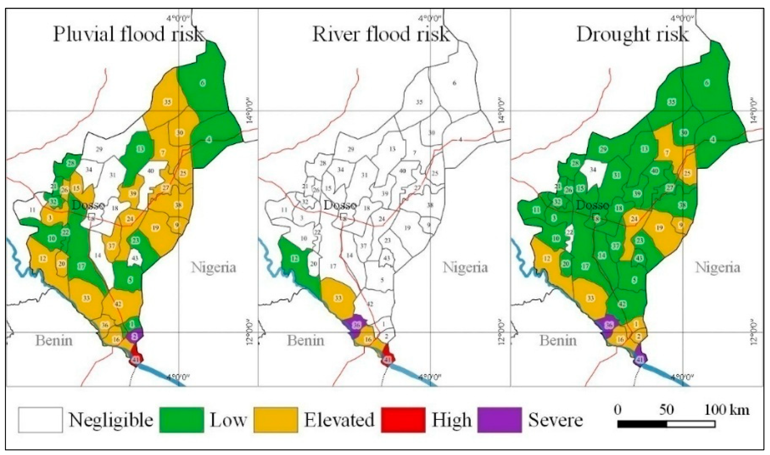
The third step involves the analysis of risk. This starts by understanding which risk, determinant, and indicator has a greater effect on the MHRI and then calculates the MHRI for each municipality in the region, representing it on a map.
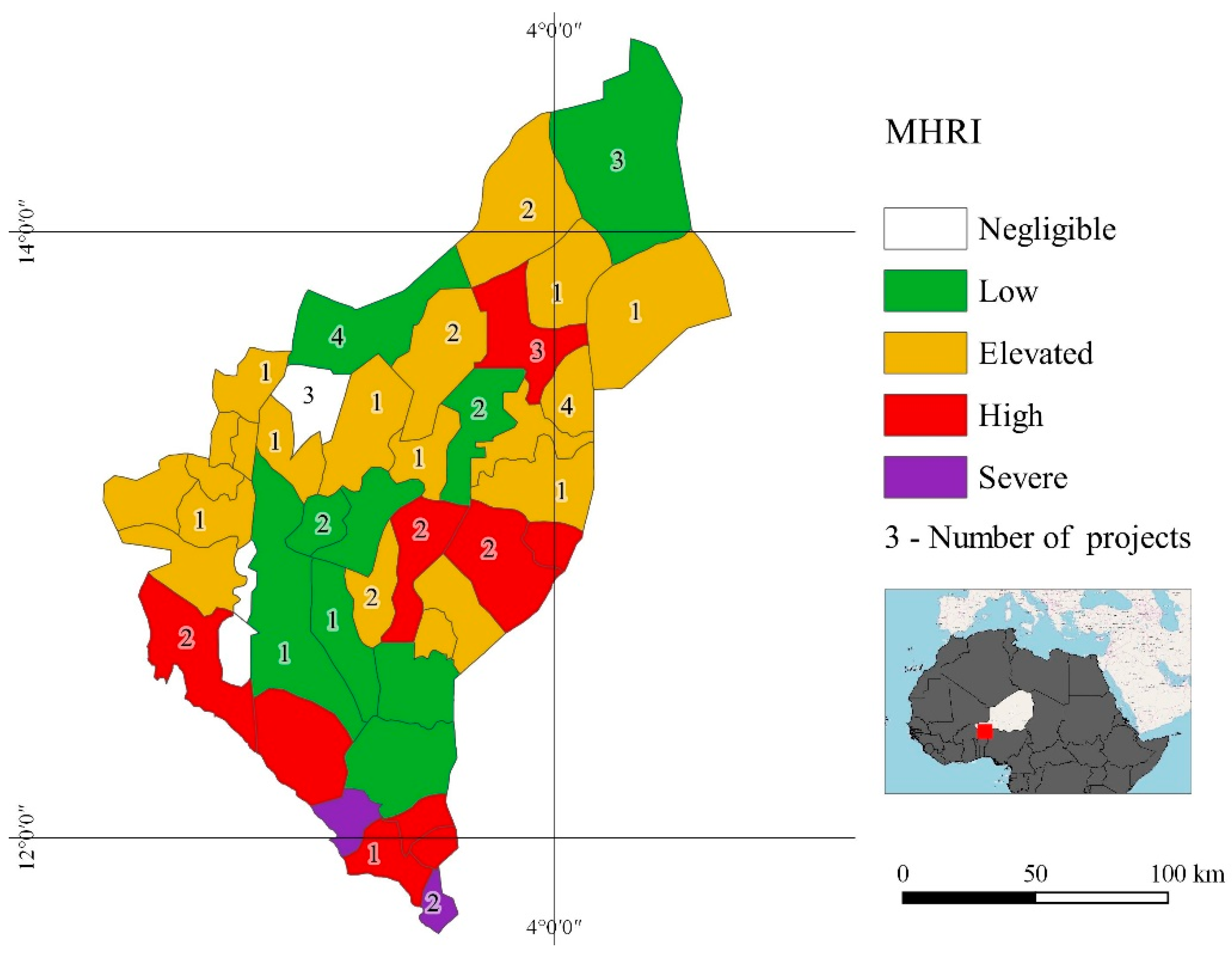
The fourth step deals with the potential use of the assessment. This becomes clear when comparing the map of the MHRI with the intervention areas of the 12 projects for climate adaptation and resilience currently running in the region and with the adaptation actions envisaged by these projects and by six MDPs.
The most significant results of the assessment concern hazard characterization during the period examined, the level of single and multihazard risk, the municipalities that are neglected by CC adaptation and resilience projects, and the inconsistencies between categories of actions envisaged by MDPs and prevailing threats.
4. Discussion
This assessment takes its cue from the statement that CC adaptation plan and project development in West Africa cannot yet base itself on local hydroclimatic risk mapping and on decision-making-oriented analyses. The main problem that needs tackling is therefore how to organize a multihazard risk assessment at a regional scale that will be useful during decision-making processes.
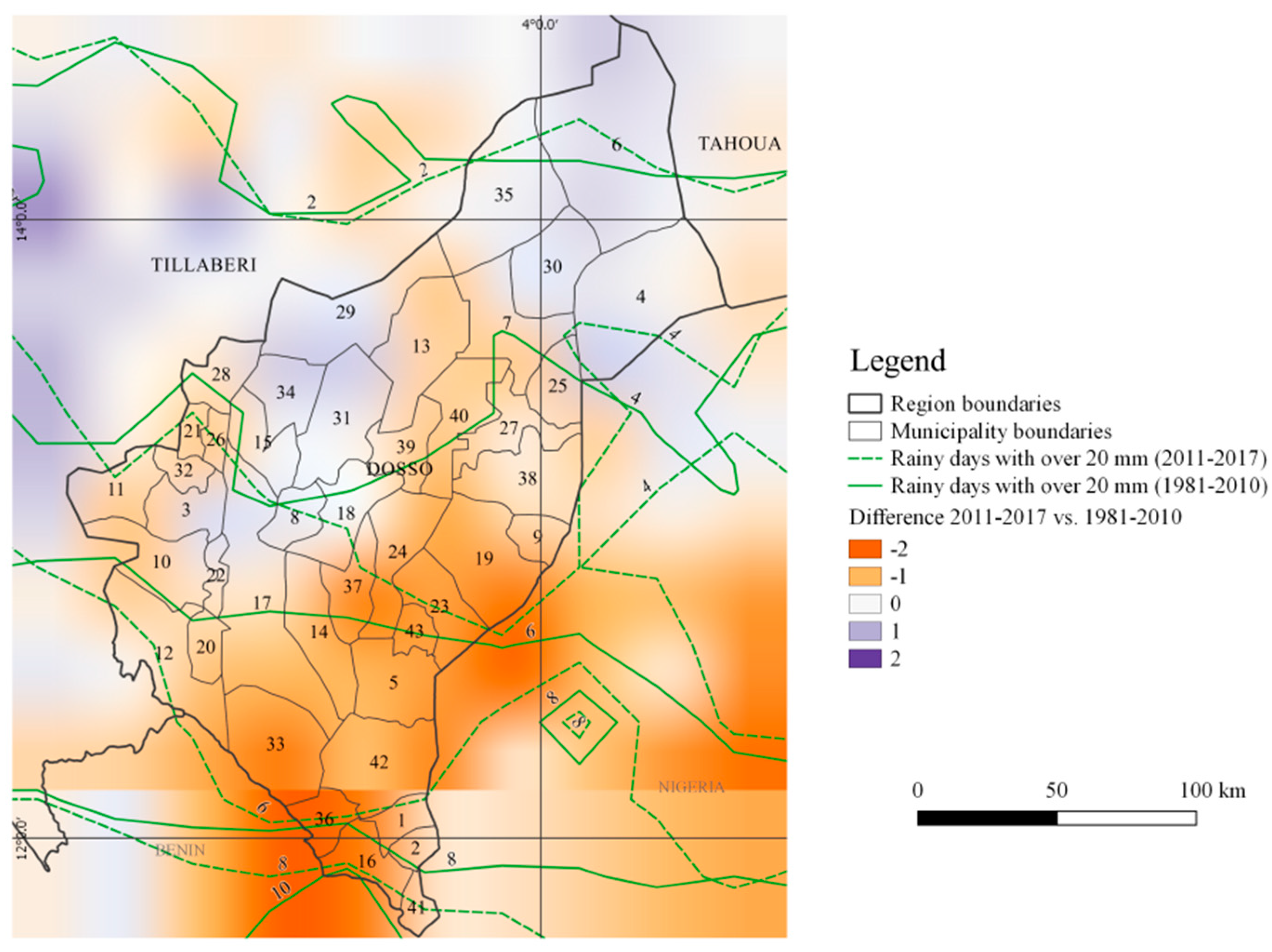
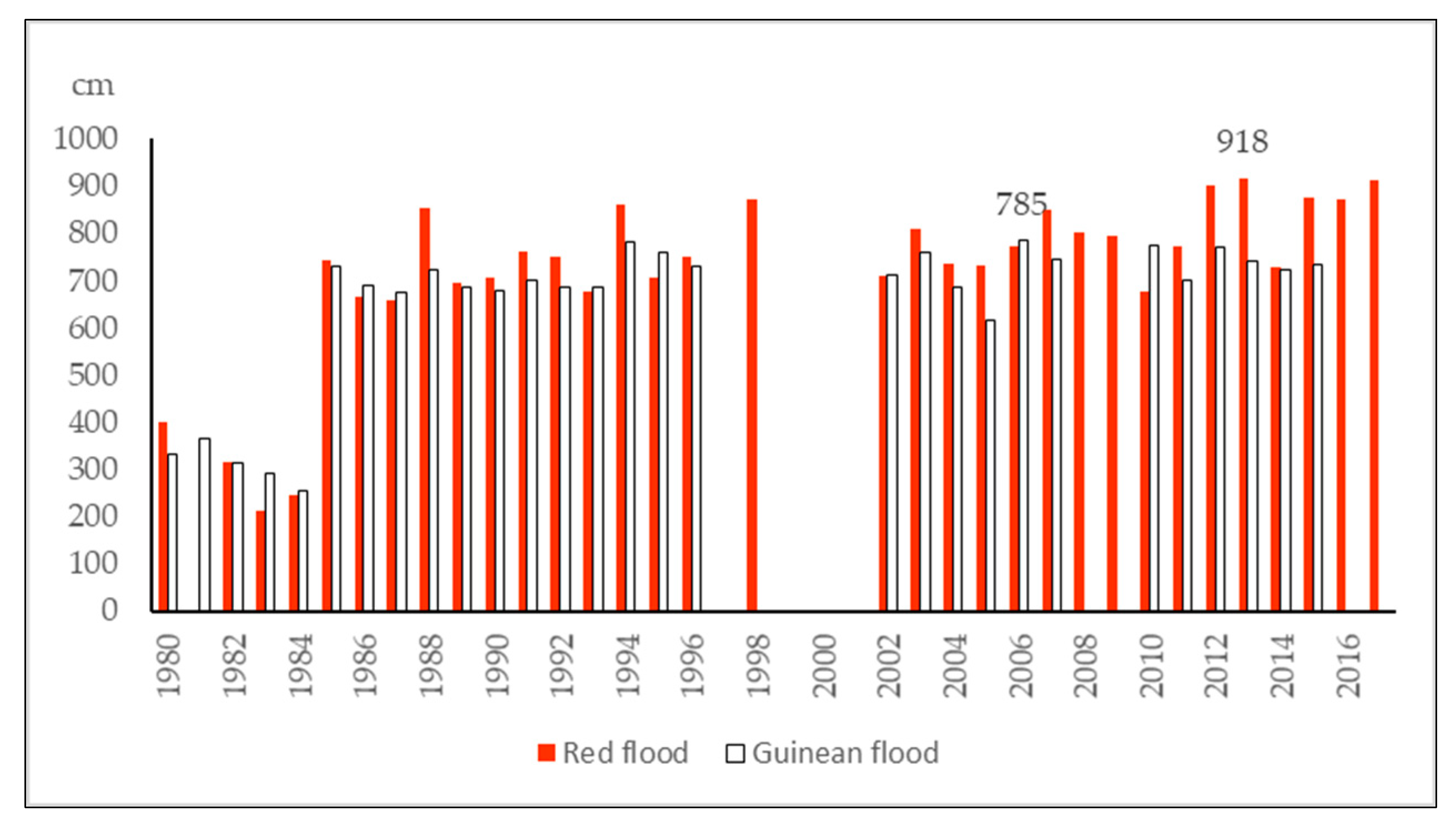
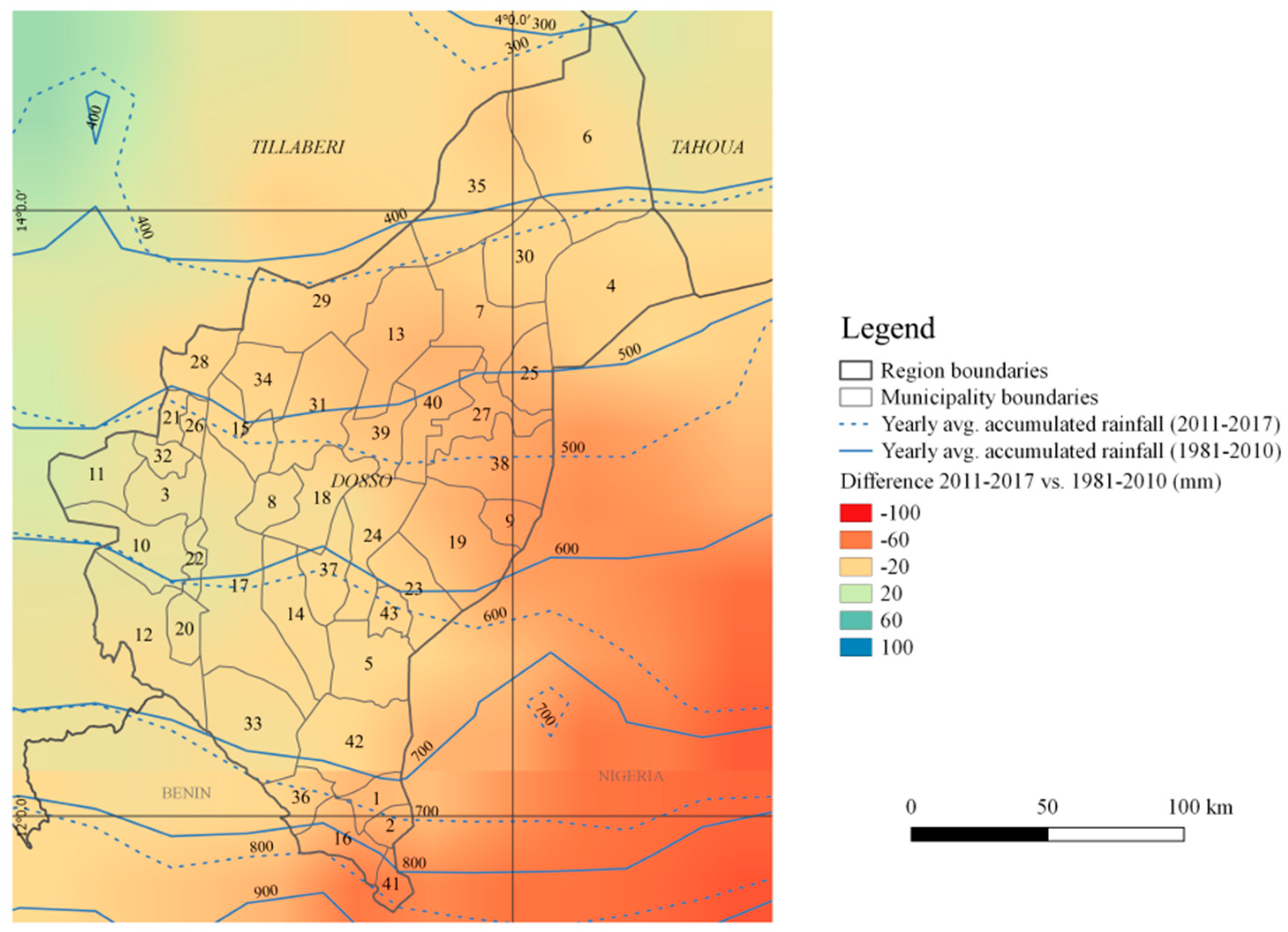
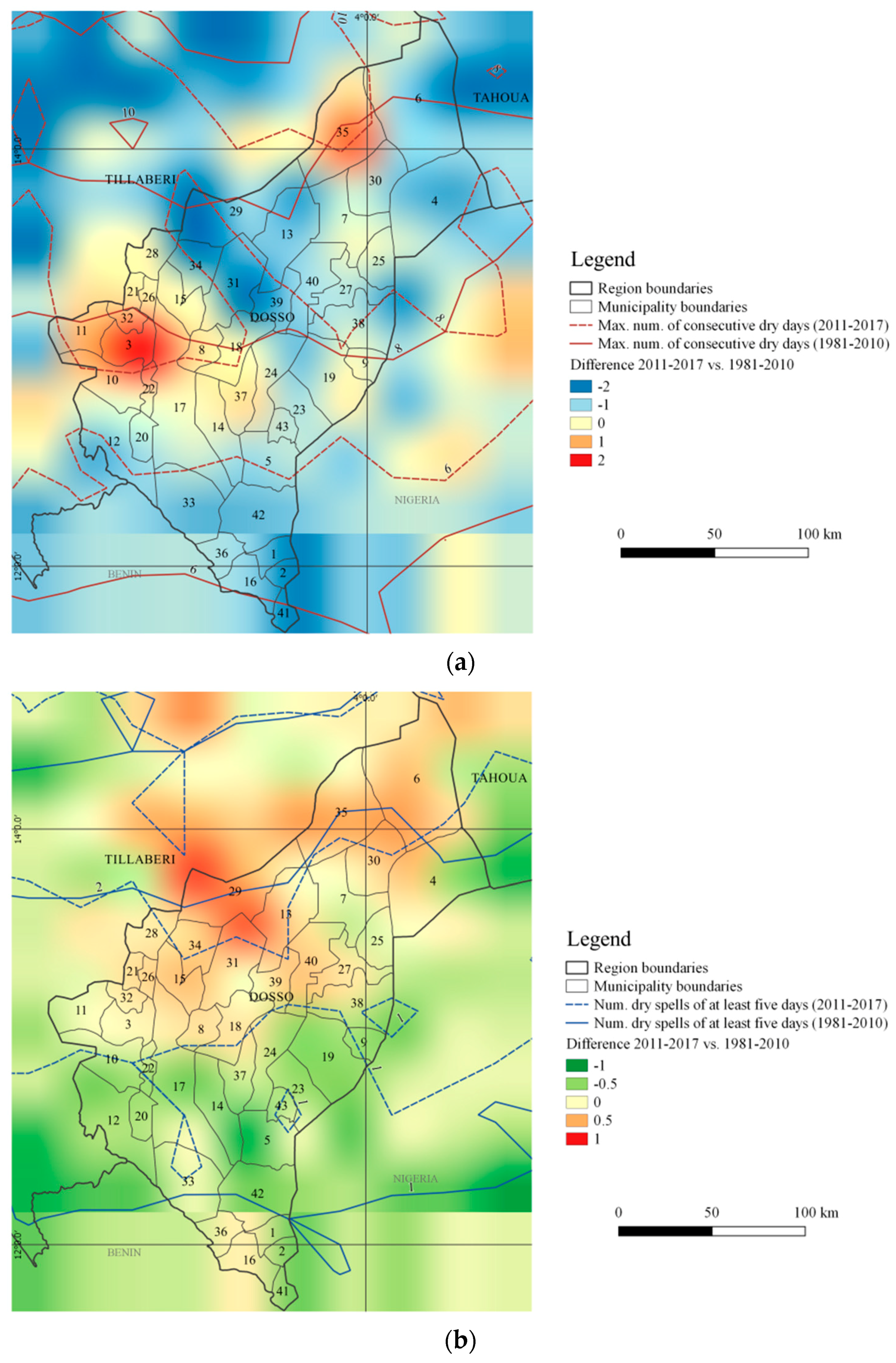
The first issue concerned climate characterization at the regional scale. Using the CHIRPS daily dataset, it proved possible to calculate trends in extreme events, extremely heavy precipitation days, and dry spells for the centroid of each municipality over the past seven years, comparing them to the previous 30 years. This characterization helps to explain why a region hit by droughts between 2011 and 2017 in the same period is affected by red floods of the River Niger higher than the previous 30 years. This paradox is explained by the analysis of extreme rainfall, the increased frequency of which contributes (accompanied by other factors) to an increased runoff and confirms, also for the Dosso region, a more general trend observed in West Africa [
91].
The second issue was how to indicate risk level. The assessment forgoes using pixels as a typical unit of representation in the spatial analyses carried out up to now in West Africa at a regional scale, preferring municipal jurisdiction [
38,
92]. Unable to monetarily quantify risk, the reference to a municipality’s demographic weight in the region makes it easier to understand the risk level.
The third issue was how to link the climate characterization and risk-level figures to recommendations that could be useful when developing plans and projects, an aspect that rarely [
17,
39,
51] had been tackled by previous risk analyses. The increased frequency of extreme rainfall events in the municipalities of BirniN’Gaoure, Dan Kassari, Dogon Kiria, Loga, Matankari, N’Gonga, and Soucoucoutane means that receptors must be protected. More frequent heavy rains justify WSC and storm water drainage. Nevertheless, L&D are also caused by the impact of heavy rains on buildings made of fragile materials and the impact on wells, fountains, and latrines at ground level, which are flooded and remain out of bounds for the entire rainy season. The assessment raises the question of a general improvement of the habitat by, for example, replacing mud roofs with corrugated iron and raising the level of the foundations of homes and the bases of wells, fountains, and latrines. Higher river flooding and the predominance of red floods as opposed to Guinean floods require the protection of rain-fed crops during the rainy season and early warning systems to store equipment and livestock in a safe place during floods. The higher number of dry spells that last longer in the municipalities of BirniN’Gaoure, Dosso, Fakara, Farrey, Garankedey, Golle, GoroubanKassam, Harikanassou, Kiota, Koyogolo, N’Gonga, Sokorbe, Soucoucoutane, and Tessa require greater attention when monitoring rainfall locally and, in particular, the adoption of adaptation strategies, such as the introduction of drought-resistant cultivars, crop diversification, changes in cropping patterns and sowing dates, as well as improved WSC to manage soil moisture.
To date, local rainfall monitoring, warnings (weather and crop bulletins), and green infrastructures (village forestation) have rarely been used in adaptation and resilience projects for the Dosso region. Over the past 20 years, aid projects in Niger have focused on food security in an area where most of the regions are affected by drought and continue to be so. Three-fourths of projects usually operate in more than one region and extend the same actions to all areas of intervention, including wetter regions like Dosso, which explains the inconsistencies.
The fourth issue concerned the extension of the assessment to other regions and its repetition over time: the weakness of previous studies. The use of information regularly gathered by public bodies at a national scale and available at the settlement and municipality level, combined with simple calculation methods, allow personnel lacking advanced skills to carry out risk tracking in any region.
We have learned two main lessons from this assessment.
The first lesson learnt is that vulnerability indicators should take their cue from an understanding of the factors that turn a local hydroclimatic event into a disaster and not from easily accessible information or field literature. Should information be lacking, it is best to resort to L&D, if available [
93].
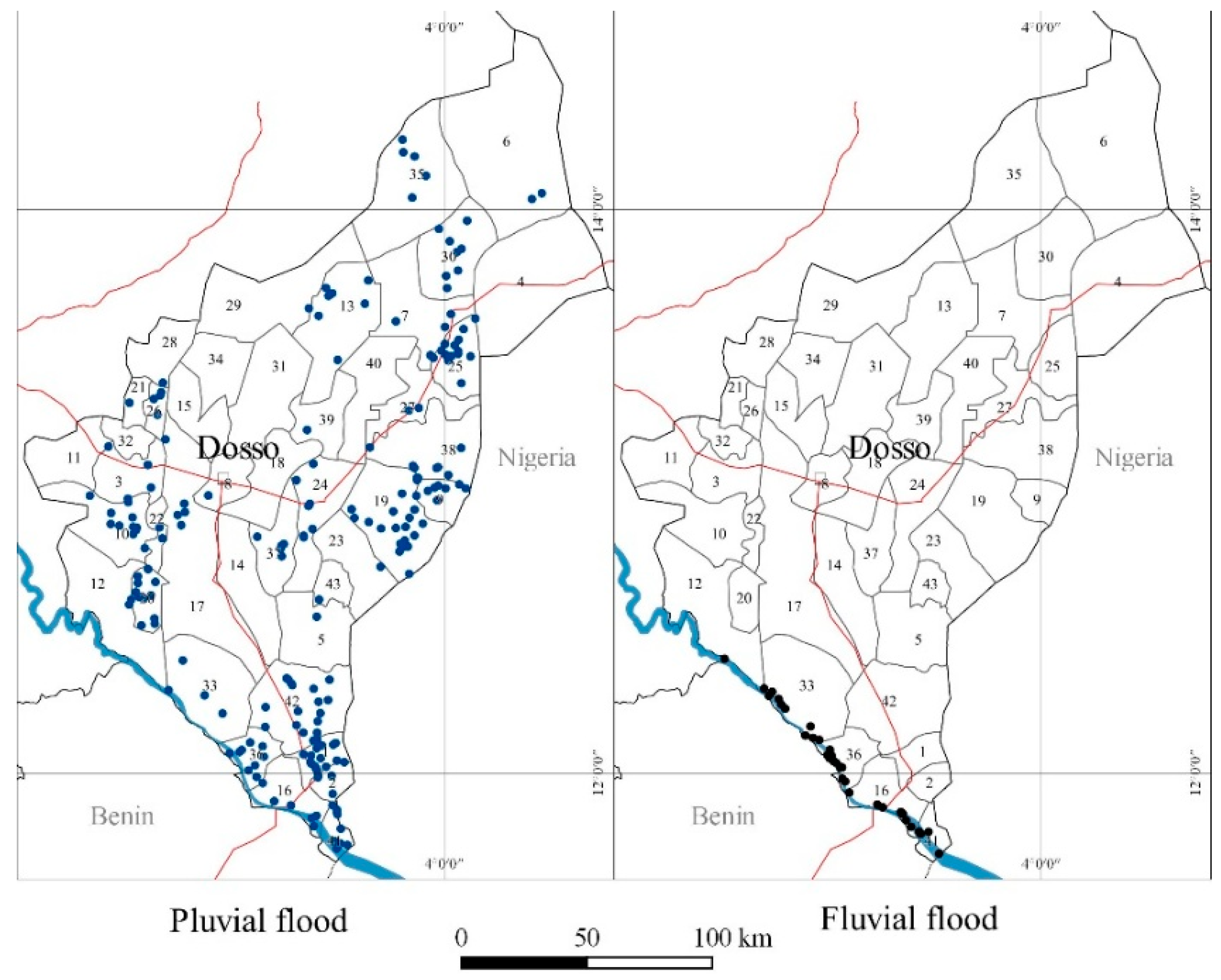
The second lesson learnt is that methods that use low-resolution DEM and satellite images to identify flood-prone areas are inadequate. If we were to apply the buffer technique or DEM to identify areas prone to flooding along the River Niger and the dallols, we would end up with an overestimation: over the past seven years, only 29% of the settlements along the River Niger, and just 20% of those in the dallols, have ever been flooded.
Three unexpected results emerged from our work.
The first unexpected result was the lack of coverage provided by global, open-access databases regarding flooding and drought compared to national ones. The former record only 18–44% of the events listed in national databases and have proved to be particularly unreliable when it comes to drought.
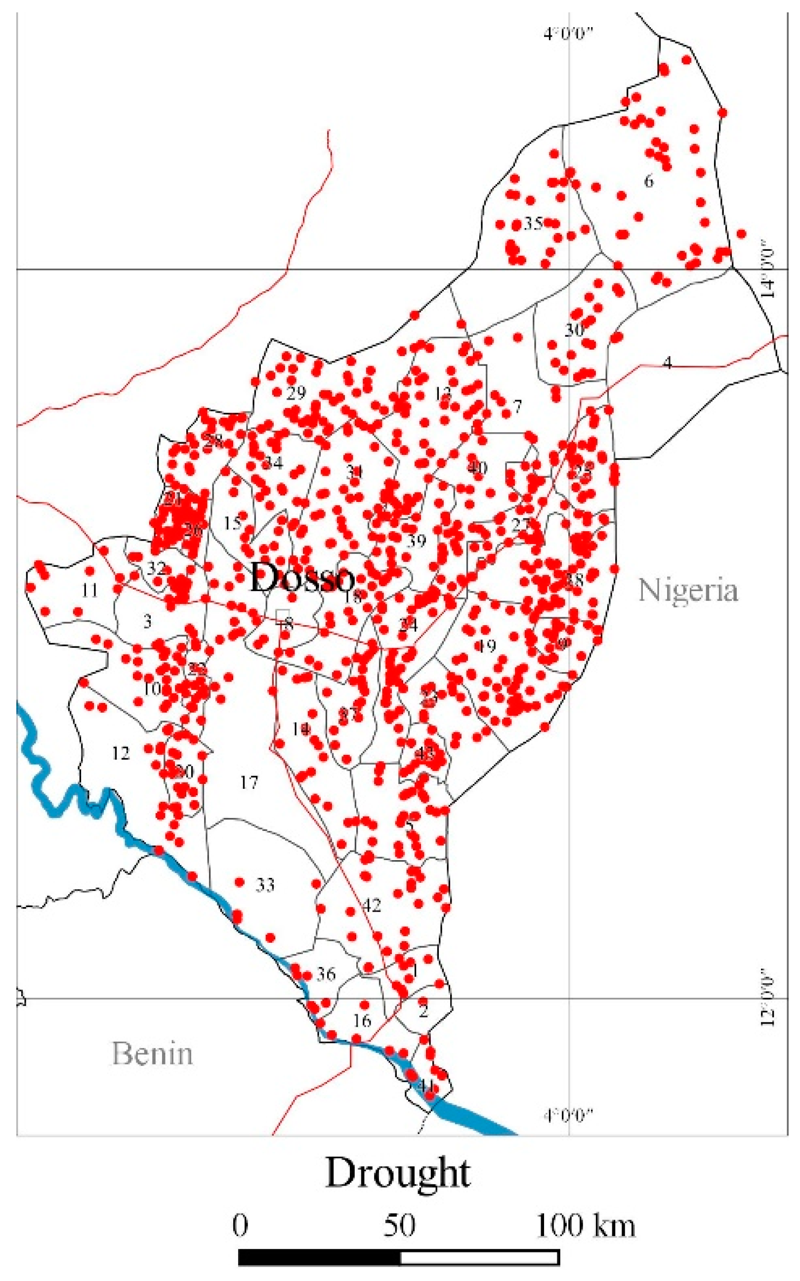
The second unexpected result of the assessment were the 121 settlements prone to multihazards (flooding and drought) scattered over no fewer than 31 municipalities. The small number of settlements repeatedly hit by floods and droughts opens at least two issues for development policies that should be ascertained. First of all, if flooding can also be an opportunity not just a disaster, for example, by encouraging flood recessional cropping in areas where it was previously impossible to do so [
94,
95]. Secondly, if floods and droughts trigger temporary or permanent migratory processes in the locations repeatedly hit: an aspect that is beginning to be studied in West Africa [
96].
The third unexpected result was the concentration of L&D due to fluvial flooding in a handful of municipalities, which produces high levels of risk compared to a situation where it is more generally distributed (drought). This is an important consideration for adaptation actions that, up to now, have rarely addressed this threat.
The shortcomings of the assessment include the use of incomplete information (L&D). This results in an underestimation of the risk level in some municipalities. The origin of flooding in the single settlements that have been hit (watershed surge, flash floods, ponds, the impact of extreme rains on receptors) is still unknown. The origin of drought is clearer but its level is not specified for all settlements. An initial improvement would be to include such information in the assessment.
A second improvement would be to financially quantify L&D, which would be possible if surveys specified the types of buildings and crops affected. This would allow us to include a level of evaluation in the assessment, i.e., to calculate the cost-effectiveness of risk reduction and adaptation in municipalities.
A third improvement would be to include local climate scenarios. The use of various different medium- and long-term climate forecasts would allow us to assess the future evolution of extreme events in the Dosso region and therefore characterize the hazard component of future risk. In this way, the planning process would be based on more concrete climate models.
The assessment ends by making four recommendations.
The first is addressed to the Ministry of Humanitarian Action and Disaster Management and concerns the completion and extension of information regarding flooding to ensure that the geographic coordinates of the places hit are always specified, as well as the origin of the flooding, the type and size of buildings hit, and the type of crops affected. This will allow us to improve the analysis and complete our assessment with an evaluation.
The second recommendation is addressed to the Ministry of Agriculture and Livestock, so that it may systematically specify the causes and extent of cereal deficit in all settlements, possibly linking this information to agrometeorological information such as the sowing date, types of crops, and the use of any water management techniques. This would allow us to improve our calculation of the drought risk level.
The third recommendation is addressed to the Ministry for Community Development and Territorial Planning and to the Directorates Regional, so that they may consider risk assessment and make it open access, updating it every few years, using it in Regional Development Plans, and requiring it to be included in MDPs.
The fourth and final recommendation is addressed to international aid organizations, so that they may consider risk assessment in identification and evaluation phases, since CC and hydroclimatic disasters could influence the impact of projects.
5. Conclusions
The number of CC adaptation plans and projects in West Africa is not keeping pace with our understanding of the climate and hydroclimatic risk at a regional level.
This article is unlike those that preceded it because it characterizes climate at a local level, it identifies the settlements at risk, it uses local sources in order to get L&D information that is more precise than the data found in global open-access databases, it analyzes risk determinants one at a time, and ranks multihazard risk using municipal jurisdiction as a minimal information unit. Its potential uses have been identified for the Dosso region (Niger).
Local planning requires high-resolution climate analysis in order to monitor the dynamics of extreme phenomena. Should a dense network of weather stations be lacking, a recurring situation in West Africa, we can combine the analysis with high-resolution rain estimate datasets. This allows us to measure hazard at a municipal scale more accurately.
Although 28% of localities and 67% of the population of Dosso have been hit by flooding or drought over the past seven years, in actual fact, 606 settlements (12% of the regional total) have been hit more than once. Therefore, there are fewer hot spots, which are geographically concentrated along the River Niger and in the dallols.
The importance of having a holistic vision of risk, as recommended by the Sendai Framework, is confirmed if we consider the 121 settlements exposed to multihazards (38 of which in the same year, see
Table S3), the distribution of CC adaptation projects that do not reflect the risk level, and MDPs with actions that do not address the main threats.
This assessment lists the places that have been repeatedly hit by flooding and drought and the municipalities that are most at risk but do not benefit from adaptation actions, as well as the types of measures that address hazards but are as yet lacking.
The use of L&D information collected on a regular basis by national bodies and the ease with which we calculate risk make the assessment applicable to other regions of Niger, as well as other countries.
The assessment is based on previous knowledge. Future improvements should include more complete data when this will be available and CC scenarios (an increase in heavy rainfall, drought) in the risk level.


