
Current Status of Groundwater Monitoring Networks in Korea


1
Department of Geology, College of Natural Sciences, Kangwon National University, Chuncheon 24341, Korea
2
Critical Zone Frontier Research Laboratory (CFRL), Kangwon National University, Chuncheon 24341, Korea
*
Author to whom correspondence should be addressed.
Water 2016, 8(4), 168; https://doi.org/10.3390/w8040168
Submission received: 2 March 2016
/
Revised: 14 April 2016
/
Accepted: 15 April 2016
/
Published: 21 April 2016
(This article belongs to the Special Issue Groundwater Monitoring and Remediation)
Abstract
:Korea has been operating groundwater monitoring systems since 1996 as the Groundwater Act enacted in 1994 enforces nationwide monitoring. Currently, there are six main groundwater monitoring networks operated by different government ministries with different purposes: National Groundwater Monitoring Network (NGMN), Groundwater Quality Monitoring Network (GQMN), Seawater Intrusion Monitoring Network (SIMN), Rural Groundwater Monitoring Network (RGMN), Subsidiary Groundwater Monitoring Network (SGMN), and Drinking Water Monitoring Network (DWMN). The Networks have a total of over 3500 monitoring wells and the majority of them are now equipped with automatic data loggers and remote terminal units. Most of the monitoring data are available to the public through internet websites. These Networks have provided scientific data for designing groundwater management plans and contributed to securing the groundwater resource particularly for recent prolonged drought seasons. Each Network, however, utilizes its own well-specifications, probes, and telecommunication protocols with minimal communication with other Networks, and thus duplicate installations of monitoring wells are not uncommon among different Networks. This mini-review introduces the current regulations and the Groundwater Monitoring Networks operated in Korea and provides some suggestions to improve the sustainability of the current groundwater monitoring system in Korea.
1. Introduction
Groundwater is the main water resource in drought seasons in the Republic of Korea (hereafter Korea; Figure 1) [1,2,3]. With growing economic development and agricultural innovation, the demand for water supply is ever increasing in Korea. In particular, dramatic changes in seasonal and annual rainfalls (precipitation) due to the changing climate has led to a nationwide effort to seek and secure alternative water resources such as seawater desalination, rainwater harvesting, and groundwater development [4,5,6,7]. Korea experiences severe droughts nearly every six years according to the modern meteorological monitoring system, which was founded in 1904 [8]. In Korea, groundwater accounts for only 11% of the total annual water consumption, but the use of groundwater is intensively elevated during dry seasons [9]. Among the total annual financial investment on water resources, only 0.5% is allocated for groundwater resource and is spent mostly on additional groundwater development in dry seasons [10]. Recent multiple prolonged droughts have drawn much greater attention to the availability of groundwater, and numerous groundwater wells have been exploited in an effort to secure more water resources. Although the impetuous development does meet expected water supply it has also produced problems such as groundwater-level decline and use of abandoned wells susceptible to contamination [4,11]. A holistic approach is required to secure sustainable groundwater resources.
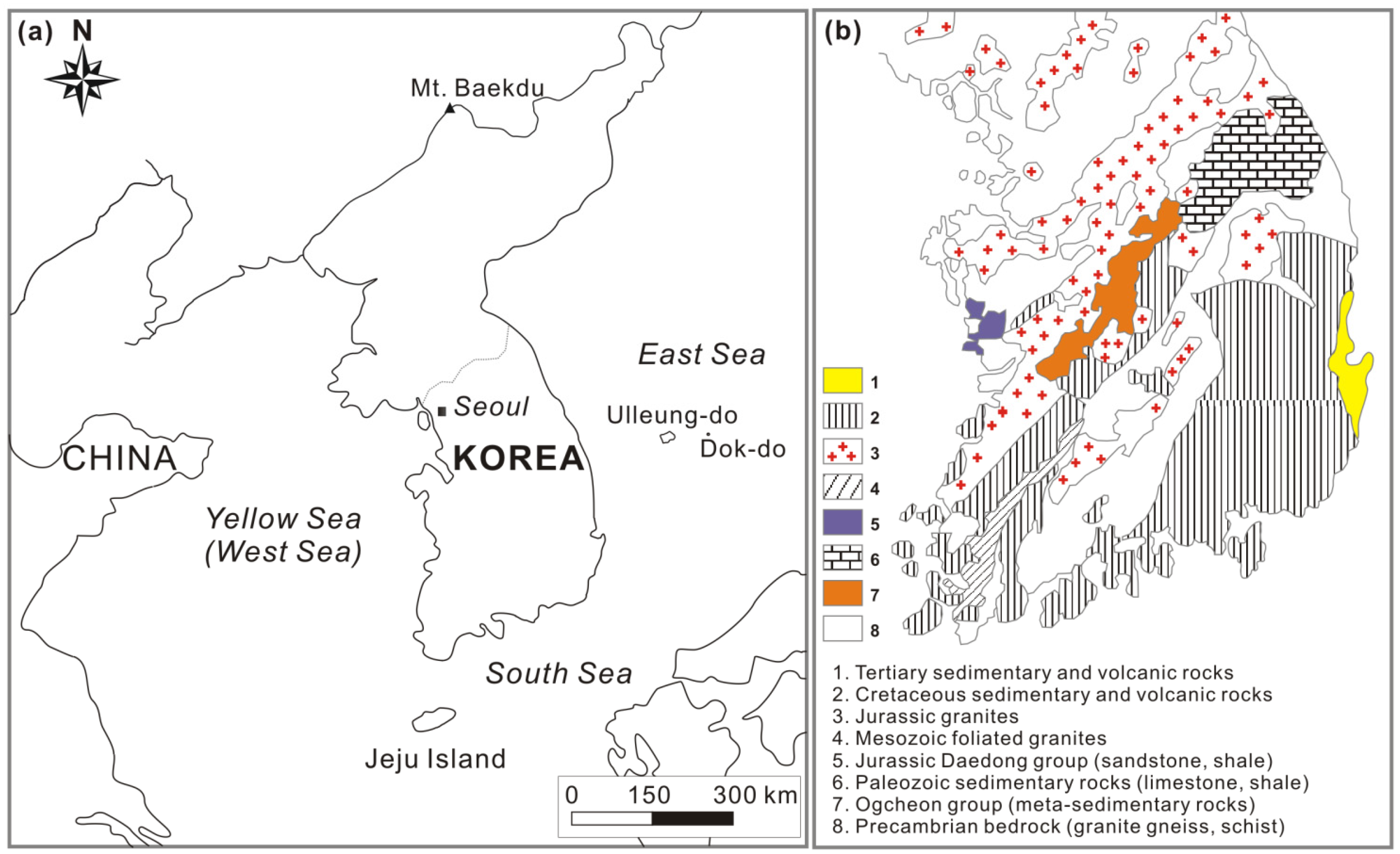
Geologically, Korea is comprised mainly of Precambrian gneiss and Jurassic granite in the middle area and Cretaceous sedimentary rocks in the southern part (Figure 1b). Quaternary alluvial deposits with high permeability and high groundwater yield (up to 800 m3/day) are mostly found along large rivers including the Han, Nakdong, Yeongsan, and Seomjin Rivers [3,9]. Therefore, the development of high production aquifers is limited [4] to low plains in the west coastal areas where most of the rice paddies are distributed and the Jeju volcanic island where groundwater is the sole water resource [12]. Because most of the country is covered by a thin (~5 m) unconsolidated sediment or soil, dominant aquifers are bedrock aquifers particularly in the hills and low relief mountainous areas [4,8] with their lateral extension being limited.
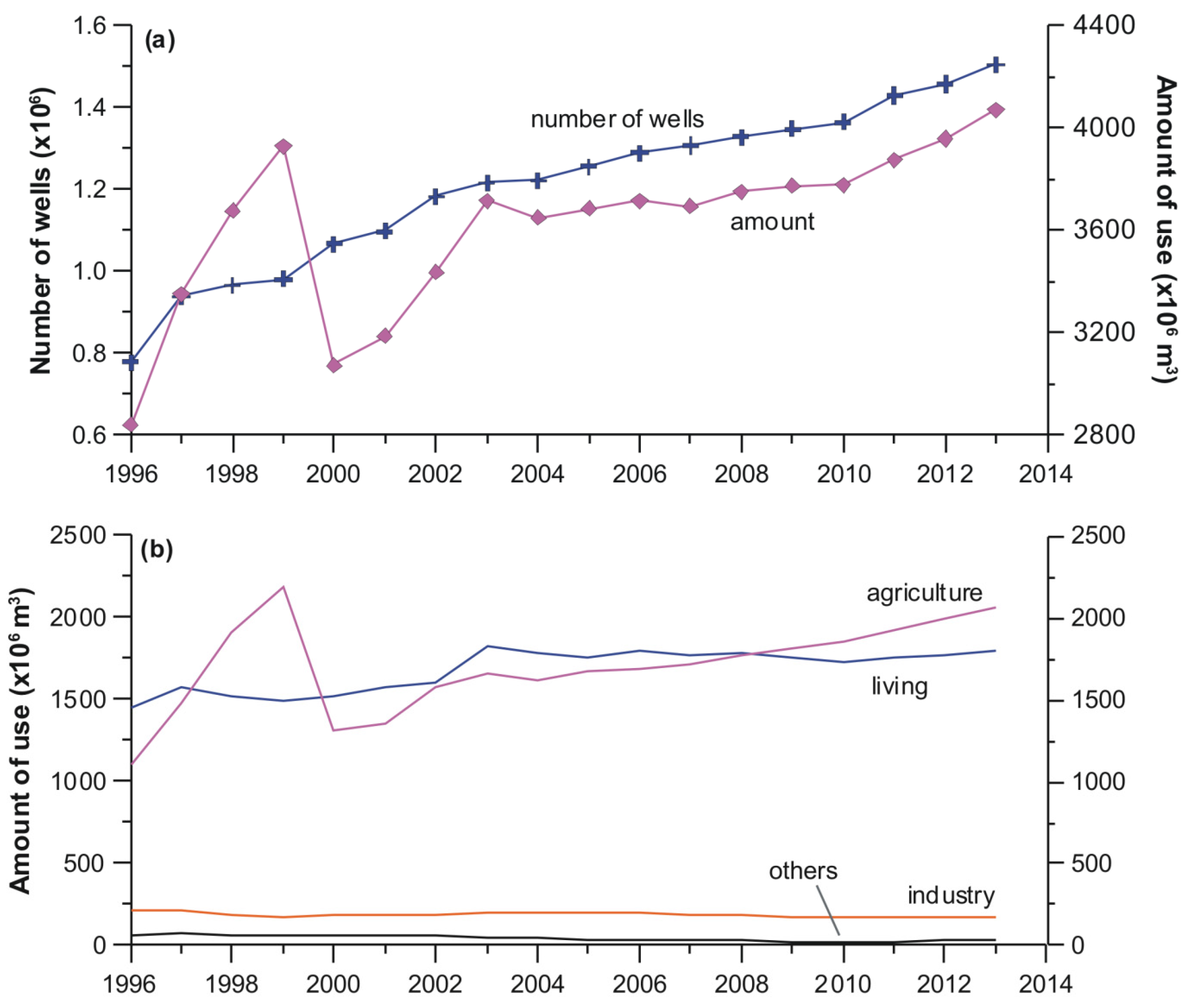
Figure 2 shows the number of wells using groundwater and the corresponding annual groundwater use in Korea for 1996 to 2013. The number of groundwater wells has been steadily increasing from 779,438 wells in 1996 to 1,506,352 wells in 2013, corresponding to a mean increase rate of 36,583 wells per year. The resulting density also increased from 7.8 to 15.1 wells/km2 for the period. The total groundwater consumption in 1996 was 2838 million (M) m3 and drastically increased to 4071 M·m3 in 2013, with a mean increase rate of 43.9 M·m3 per year. The groundwater consumption per unit area (km2) also increased from 28,461 to 40,822 m3. The groundwater pumping volume per well, on the contrary, slightly decreased from 3641 m3/year (=9.9 m3/day) to 2702 m3/year (=7.4 m3/day). The amount of groundwater use according to the purpose is shown in Figure 2b. In 1996, living (domestic) purposes (51.2%) comprised the largest proportion of groundwater usage while agricultural use was the second largest (39%). Even though groundwater use for living purposes has increased slightly for 2010–2013, it has been exceeded by agricultural groundwater use since 2009. Because no substantial changes occurred in living, industrial, and other uses, agriculture has mainly led the increase in the total groundwater use. This is largely due to the fact that agriculture groundwater use is exempted from usage fees under the current policy to improve agricultural productivity and farmers’ welfare.
With the increasing trends in groundwater use, various problems have been encountered including significant decline in the groundwater level, groundwater contamination by chlorinated solvents and petroleum hydrocarbons, and land subsidence [3,13,14,15,16]. To address these problems, the Korean government implemented laws and regulations which oblige the government ministries to monitor groundwater quantity and quality [9,17]. Currently, there are six groundwater monitoring networks operated and managed by governmental organizations for different purposes. This paper introduces the current status of the main groundwater regulations and monitoring networks and provides some perspectives to improve the network system.
2. Laws and Regulations
Table 1 summarizes the main laws and authorities regulating groundwater use in Korea. The primary law controlling groundwater affairs is the Groundwater Act (Act No. 4599 in 1993; No. 13383 as of 23 December 2015), which was implemented in late 1993. This law embodies many duties and rights of the central and local governments and the public to secure groundwater resources [17]. According to Article 5 of the Act, the Ministry of Land, Infrastructure, and Transport (MOLIT) conducts a basic investigation regarding the reserve characteristics and the available volume of groundwater throughout the country. Complying with this article, the K-water, a governmental agency operated by the MOLIT, has conducted groundwater investigations from 1997 and evaluated 52% of the total area of the nation as of 2012. Hydrogeological maps (groundwater atlas) have been produced at city and county scales.
Article 6 obliges the MOLIT to establish a comprehensive groundwater management plan. The national plan designs general management strategies for groundwater preservation and quality conservation and characterizes the reserves and amount of exploitable groundwater as well as the conditions for groundwater utilization. This plan is renewed every 10 years (2002, 2012) and was first established in 1996 in order to reflect the changes in hydrological and societal conditions. Local governments (provinces, cities, and counties) also establish their own groundwater management plans. As of 2012, 16 metropolitan cities and provinces, and 11 counties completed their own management plans [18]. Article 17 further enforces the MOLIT to implement nationwide and local groundwater monitoring systems called the National Groundwater Monitoring Network (NGMN) and the Subsidiary or Local Groundwater Monitoring Network (SGMN or LGMN), respectively. All these monitoring data are gathered at the National Groundwater Information Center (www.gims.go.kr) under Article 5.2 and are available to the public.
The Hot Spring Act controls groundwater with temperature over 25 °C [19,20]. As of 2014, 1213 hot spring wells are used mainly in the wellness industry and spa therapy business, and 71% of them are tapped at a depth greater than 500 m (mean = 736 m, maximum = 2003 m) [21]. The hot spring business attracts more than six million people every year and tries to meet the increasing demand. The Act strictly regulates the development of hot spring water: environmental impact assessment is required to have ministry approval for development (Article 10.3); the water quality is monitored as to the health effect, major constituents, and water temperature (Article 11). However, drastic decline of groundwater level, water depletion, and water contamination are often reported mainly due to injudicious exploitation of deeper water [22] in the current absence of regulation about tapping depths for the wells [23].
When groundwater is used for drinking water, the Drinking Water Management Act applies under the authority of the Ministry of Environment (ME). The Act addresses the management of natural water used for drinking purpose, treated tap water, drinking spring water (bottled groundwater), drinking saline water, and drinking deep sea water. This law obliges the ME to manage clean drinking water quality (Chapter 2, Articles 5–8). When groundwater is developed for commercial bottled water, a strict environmental impact assessment is required (Articles 13–18). This law also requires the private enterprises abstracting groundwater and selling bottled groundwater to regularly monitor the groundwater level and its quality, and to report the monitoring data to the environmental authority.
Groundwater use in agriculture is guided by the Rearrangement of Agricultural and Fishing Villages Act. This law obliges the Ministry of Agriculture, Food, and Rural Affairs (MAFRA) to establish management plans for sustainable agricultural groundwater. The MAFRA operates the Rural Groundwater Monitoring Network (RGMN) to regularly monitor the water quantity (groundwater level) and quality. The Korea Rural Community Corporation, a governmental agency under the supervision of MAFRA, also operates the Seawater Intrusion Monitoring Network (SIMN) complying with the enforcement of the law to protect rice paddies in coastal areas from seawater intrusion. On the other hand, the groundwater and related facilities used in military operations are regulated by the Act on National Defense and Military Installations Projects. The jurisdiction authority is the Ministry of National Defense. The groundwater facilities (wells) prepared for national emergencies (war, disasters, etc.) are managed by the Ministry of Public Safety and Security following the Framework Act on Civil Defense.
Jeju Island (Figure 1) is the largest volcanic island and a special self-governing province in Korea. This island has the most distinctive water condition in the country. Groundwater is nearly the sole source of water supply as there are no perennial rivers and streams in Jeju [24]. The Special Act on the Establishment of Jeju Special Self-Governing Province and the Development of Free International City exclusively regulates all groundwater and related facilities on the island. The local government of the island operates its own groundwater monitoring network as well.
As listed in Table 1, groundwater in Korea is regulated by multiple subdivided laws, each law with its own distinct purpose. Because of this mission-based subdivision, one groundwater source is often managed by several laws and authorities. Complementary approaches between different authorities are expected in water management, but the subdivided laws indeed complicate comprehensive groundwater management. A comprehensive law that integrates all groundwater affairs has long been requested but to date, it has not been established.
3. Groundwater Monitoring
Table 2 summarizes six representative groundwater monitoring networks and specific operations which are enforced by the relevant laws listed in Table 1. This section introduces the current status of each monitoring network.
3.1. National Groundwater Monitoring Network (NGMN)
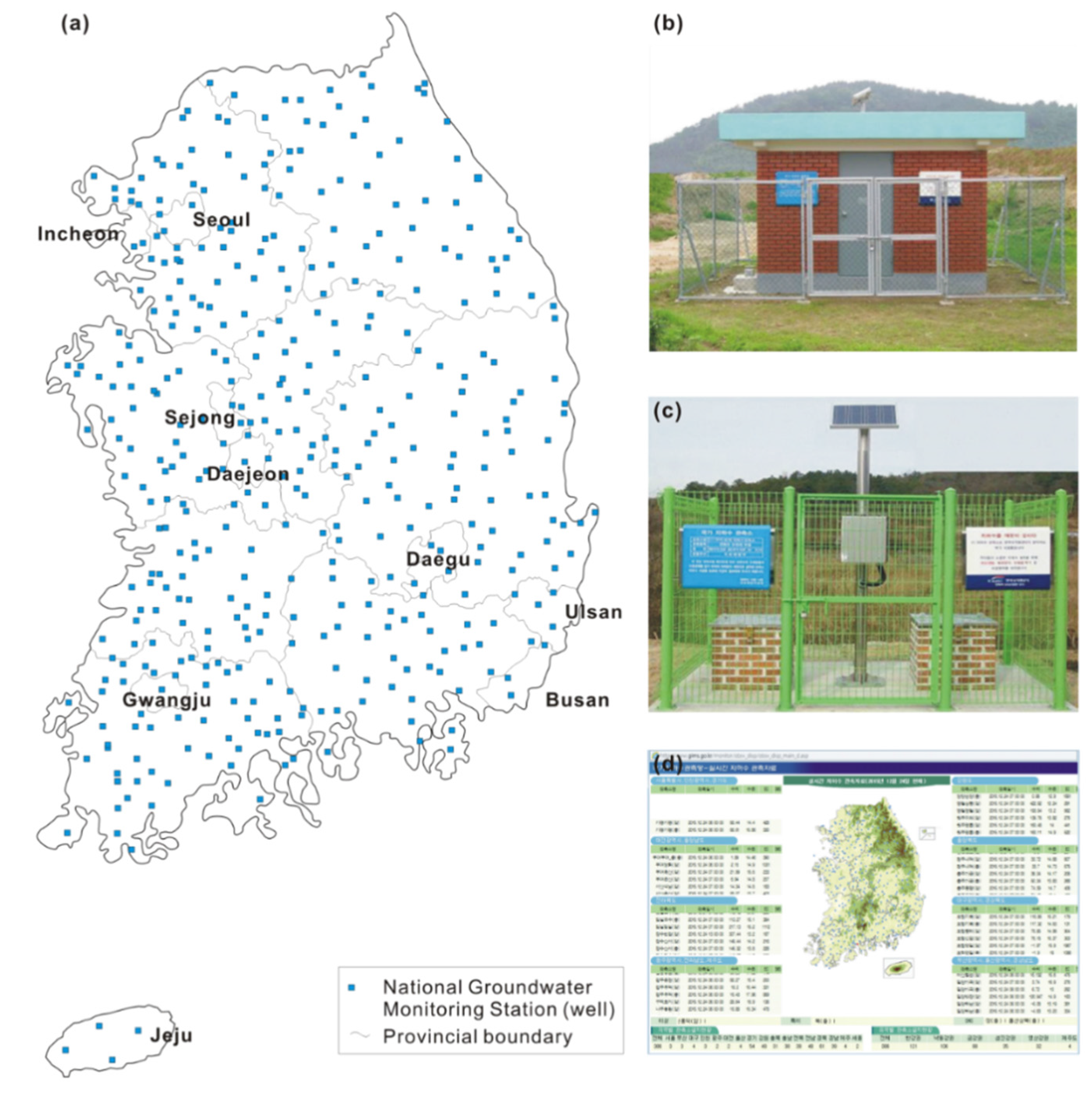
The NGMN is the primary groundwater monitoring network in Korea. Under the Groundwater Act, the MOLIT and K-water have installed groundwater monitoring stations since 1995 [10,17,25]. A total of 386 stations were installed as of 2015 (Figure 3a) and an extra 133 stations will be installed by the end of 2016. This law aims to monitor groundwater for the whole nation with a spatially equal density of stations considering the local geology [26]. Each station has basically two monitoring wells, one is for shallow groundwater in alluvial deposits and/or unconsolidated sediments and the other is for deep groundwater in bedrock aquifers [17]. The monitoring wells in a station are protected with a steel fence and/or a brick house (Figure 3b,c). Among 386 stations, 166 stations are implemented with two types of wells, and the other stations have only a single deep well (see Table 2). The mean well depths are 20 and 70 m for shallow and deep groundwater wells, respectively [10,27].
Each monitoring well is equipped with an automatic data logger that measures the water level, water temperature, and electrical conductivity (EC) every hour. The measured data are automatically transmitted to a data collecting server system in the K-water via wireless telecommunication in real time. The K-water provides real-time groundwater data to the public on a website (www.gims.go.kr; Figure 3d). If any issues arise including sensor malfunction and telecommunication errors at a station, a maintenance team is immediately dispatched to resolve them [10]. The monitoring data are also published in the annual monitoring report book.
The NGMN monitoring data collected for 1996–2008 demonstrated that the groundwater levels decreased in both shallow and deep wells by 70.8% and 68.1%, respectively, during the period [27]. The water temperature increased with a strikingly high rate of 0.04–0.09 °C/year in the majority of the monitoring wells (82.8% of shallow wells and 68.8% of deep wells). A recent study which analyzed the NGMN data for 2000–2010 also confirmed the general nationwide decreasing trend of the groundwater levels and an increasing rate (0.10 °C/year) of groundwater temperature [28]. The NGMN data indicate increased groundwater use and air temperature due to climate change for the last two decades [27,28].
3.2. Groundwater Quality Monitoring Network (GQMN)
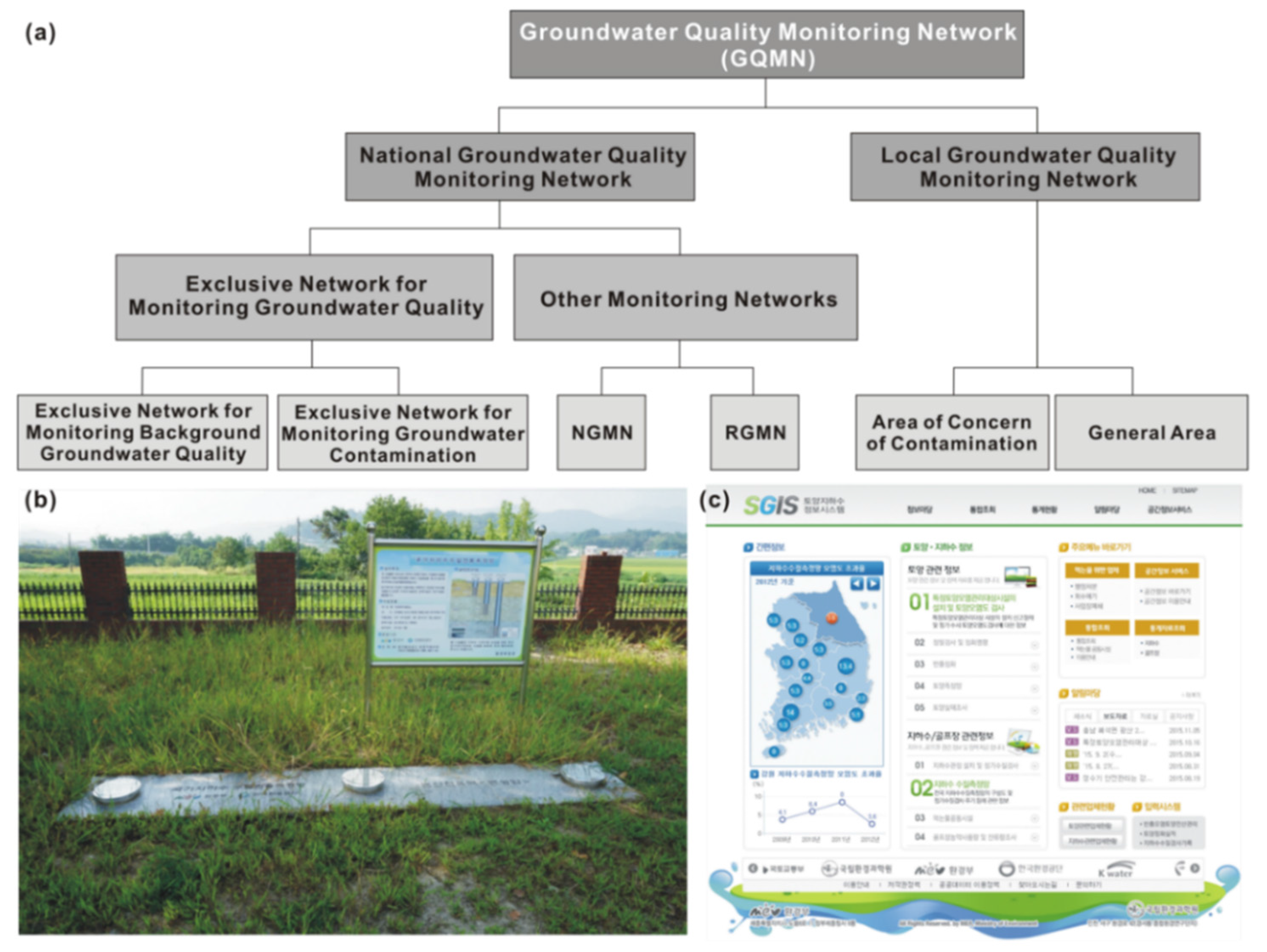
Groundwater quality is controlled by the Ministry of Environment (ME) under Article 18 of the Groundwater Act and Article 9 of Enforcement Rule Regarding Groundwater Quality Conservation (Ordinance of the ME). The ministry (and regional offices) and provincial governments have monitored the groundwater quality through GQMN since 1996. The GQMN is divided into the national GQMN and the local GQMN (Figure 4a). The national GQMN is installed and operated by the central government and its affiliated organizations, while the local GQMN is governed by provincial governments. The national GQMN has four other monitoring networks: two exclusive networks in addition to NGMN and RGMN. The first exclusive (monitoring only) network monitors the background quality in clean areas, and the second observes the areas susceptible to contamination (Figure 4b). These two exclusive monitoring networks are operated by ME and its affiliated organization, the Korea Environment Corporation. The local GQMN uses already-installed groundwater wells in two separate regions: residential and agricultural regions and industrial, landfill, and mining regions. The GQMN had a total of 3141 monitoring wells in 2014 (Table 2).
While the GQMN constantly monitors the water quality, thorough analysis is conducted at least twice a year for all except the two exclusive networks (Table 3). This analysis examines 19 groundwater quality parameters which include pH, total coliform, NO3−, Cl−, Cd, As, CN, organic P, phenol, Pb, Cr6+, TCE, PCE, 1,1,1-TCA, benzene, toluene, ethylbenzene, xylenes and EC [29]. For the exclusive networks, a more vigorous analysis is performed four times a year with 67 parameters, including basic field measuring parameters (pH, EC, DO, temperature, ORP), major cations and anions, and drinking water standard parameters like general bacteria, total coliform, fecal coliform, Pb, F, Hg, CN, Se, NO3, U, phenol, diazinon, parathion, etc. The analysis results are reported to the ME and the data are available to the public via a website (sgis.nier.go.kr; Figure 4c) managed by the National Institute of Environmental Research. The ME plans to expand the GQMN to have 37,000 monitoring wells by 2030 and to analyze 59 parameters including the current 20 parameters similar to the analysis conducted in the United States, the Netherlands, and Japan.
According to the analysis of 4952 samples from 2606 wells conducted by the GQMN in 2012, 322 samples (i.e., 6.5%) had values for some monitoring parameters that exceeded the Korean groundwater standards. In 2011, 8.0% of the collected samples exceeded the standards [30]. Among the monitoring parameters, total coliforms, NO3−, Cl−, TCE, As, and PCE were the most problematic [31]. High levels of TCE and PCE levels are frequently reported in industrial and urban areas, while high NO3− levels are reported in shallow groundwater in rural areas [13,14,30,31]. Based on the monitoring data, the ME closed contaminated wells or remediated contaminated groundwater to mitigate the consequences of groundwater contamination.
3.3. Seawater Intrusion Monitoring Network (SIMN)
Excessive groundwater use for agriculture and sea-level rise have resulted in seawater intrusion in coastal aquifers [32,33]. In agricultural areas near the coast, the MAFRA and Korea Rural Community Corporation (KRC) have operated the SIMN since 1998, complying with Article 15 of the Rearrangement of Agricultural and Fishing Villages Act and Article 17 of the Groundwater Act [34,35]. As of 2014, a total of 73 monitoring stations (145 monitoring wells) were installed (green filled rectangles in Figure 5a). Each station has one to three monitoring wells (average of two) arranged perpendicular to the coast line, and each well is equipped with an automatic data logger, solar power panels, and a wireless telecommunication terminal (Figure 5b).
The probes connected to the data logger measure the groundwater level, EC and water temperature every hour. The measured data are automatically transmitted in real time to a central KRC server and the public can access the monitoring data over the internet (www.groundwater.or.kr; Figure 5d). While the automatic monitoring system collects data every hour, a full vertical logging of EC and water temperature and a groundwater quality analysis are conducted at least once per year. From the vertical loggings, any progress of seawater intrusion or potential advancement of the seawater-freshwater interface is evaluated. A vertical electrical sounding is often conducted to supplement the vertical logging data [36]. In the seawater intrusion evaluation, the levels of Br− and Cl−, Cl−/HCO3− molar ratio, and Piper diagram are considered. A recent study [37] reported that 41.4% of the monitored groundwater wells are impacted by seawater intrusion and the intrusion is still in progress. Continuing sea-level rise further aggravates the groundwater supply in coastal areas [11,38]. The MAFRA and KRC plan to construct underground dams to protect groundwater resources from seawater encroachment.
3.4. Rural Groundwater Monitoring Network (RGMN)
With growing agricultural groundwater use (see Figure 2b), the RGMN was established by the KRC to monitor groundwater changes affected by agricultural activities, complying with Article 15 of the Rearrangement of Agricultural and Fishing Villages Act and Article 17 of the Groundwater Act [39]. The monitoring wells are newly installed in bedrock aquifers (well depths of 48–150 m, mostly 80 m) near paddy and vegetables fields (Figure 5c). Starting with two monitoring wells in 2002, the installation of 147 monitoring wells were completed over the country in 2014 (red filled circle in Figure 5a), and the RGMN plans to have a total of 1056 monitoring wells by 2021 [39]. Similar to the SIMN, groundwater level, water temperature and EC is measured every hour using submerged probes, and vertical logging of water temperature as well as EC and groundwater chemical analyses are performed every year [39,40]. The hourly measured data are automatically sent to the KRC data server and are available to the public (Figure 5d).
The chemical analysis conducted in the RGMN examines the level of major ions, Ca2+, Mg2+, Na+, K+, Cl−, HCO3−, SO42−, and NO3−. Considering the calculated sodium adsorption ratio (SAR < 15) and levels of EC (1000 μS/cm), the suitability of groundwater for agricultural use (paddy and vegetables fields, horticulture) is evaluated. According to a 2014 monitoring report [39], 72.2% of the monitoring wells showed a fluctuation of 2 m in the annual groundwater level and groundwater temperature ranged between 12.9 and 17.9 °C (mean = 15.3 °C). The EC varied from 89 to 857 μS/cm, except for one monitoring well in a coastal paddy field [39]. The groundwater is largely a Ca-HCO3 type (58.6%), which is a typical shallow groundwater affected by the atmosphere [32,41]. Compared to other monitoring networks, the RGMN lacks comprehensive analysis studies of the monitoring data.
3.5. Subsidiary or Local Groundwater Monitoring Network (SGMN or LGMN)
The SGMN (or LGMN) fills the gaps in the current monitoring wells of the NGMN, which is sparsely distributed over the country [10,26,42]. According to Article 17 of the Groundwater Act, local governments (cities and counties) are required to establish auxiliary groundwater monitoring wells by using existing wells or installing new wells to check the groundwater level changes (water temperature and EC monitoring is optional, depending on the local governments), and to report the results to the MOLIT [43]. The groundwater level should be measured manually or automatically at least once per month (Article 27 of Enforcement Decree of the Groundwater Act). The total target number of monitoring wells for the SGMN is 3000 by 2021 and 4000 by 2031 [18].
Table 4 shows the current status of the SGMN by province. The SGMN has already installed 60% of the total number of wells projected for 2021, except in two metropolitan cities, Incheon and Gwangju. Among 1803 monitoring wells, 36.1% are newly installed wells for monitoring purposes. Interestingly, automatic measurement of the groundwater level is not mandatory, but a very high percentage (60.8%) of the monitoring wells are equipped with automatic data loggers and remote terminal units (RTU) for data transmission, thanks to the low maintenance cost of the electronic devices and internet services. Including semi-auto systems (automatic measurement but no RTU), automatic measurement systems account for 75.5% of the SGMN, and only 24.5% of the stations manually measure the groundwater conditions.
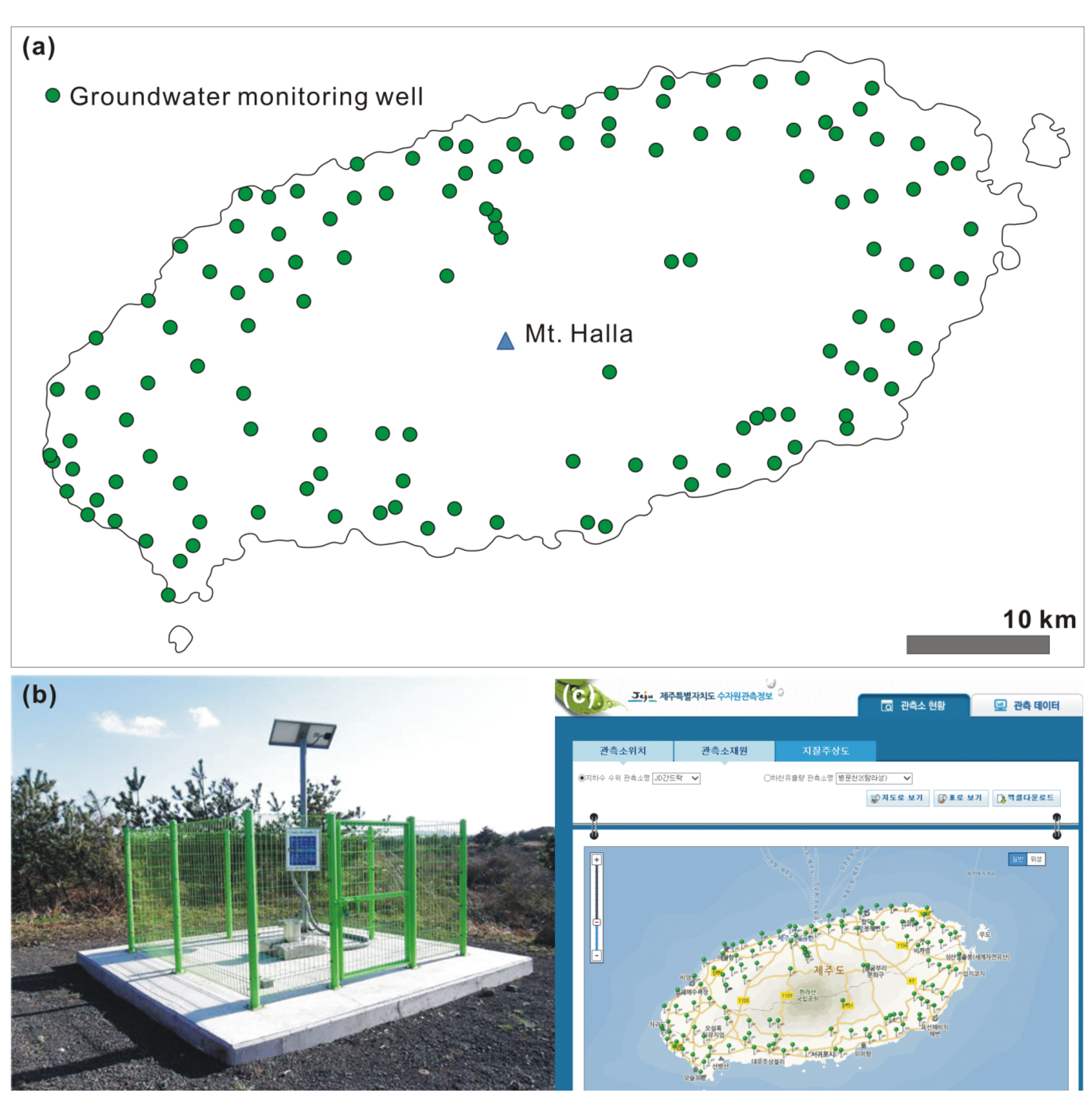
Groundwater on Jeju Island is controlled by the Special Act rather than the Groundwater Act (see Table 1). The island has operated an independent groundwater monitoring network since 1991 (Figure 6a). Strictly speaking, Jeju is not included in the SGMN by the Groundwater Act, and there are 132 local monitoring-only wells (well depths 100–600 m; Figure 6b). The main purpose of the Jeju local groundwater monitoring network is to protect the sole water resource (groundwater) from seawater intrusion or any anthropogenic pollution [44]. Groundwater use on the island has been steadily increasing since 1993, when groundwater data were first officially collected. Because groundwater is predominantly used for agriculture and farming (66.5%), which often occur in coastal low and middle areas, seawater intrusion is a potential threat [45,46]. With the intrusion concern, the monitoring wells are arranged parallel to the coast lines (Figure 6a). All the hourly measured data including water level, water temperature, and EC are available to the public via a website (www.jejuwater.go.kr; Figure 6c).
A study which analyzed the monitoring data for 2001–2005 [44] reported that the groundwater levels decreased at a rate of 0.5–4 m/year from most monitoring wells (78.1%). In particular, Jeju city, a north coastal city on the island showed the greatest decrease rate (4 m/year). The east region of the island showed the highest EC values (up to 40,000 μS/cm) with increasing trends, an indication of significant and progressive seawater intrusion. A recent study [45] using monitored data for a longer period (2001–2009) also confirmed the decreasing trend of the groundwater levels from most monitoring wells (79.8%). This is a serious threat to the water security of the island. Therefore, appropriate measures are required to mitigate the groundwater level decline and aggravating seawater intrusion on the volcanic island.
3.6. Drinking Water (Groundwater) Monitoring Network (DWMN)
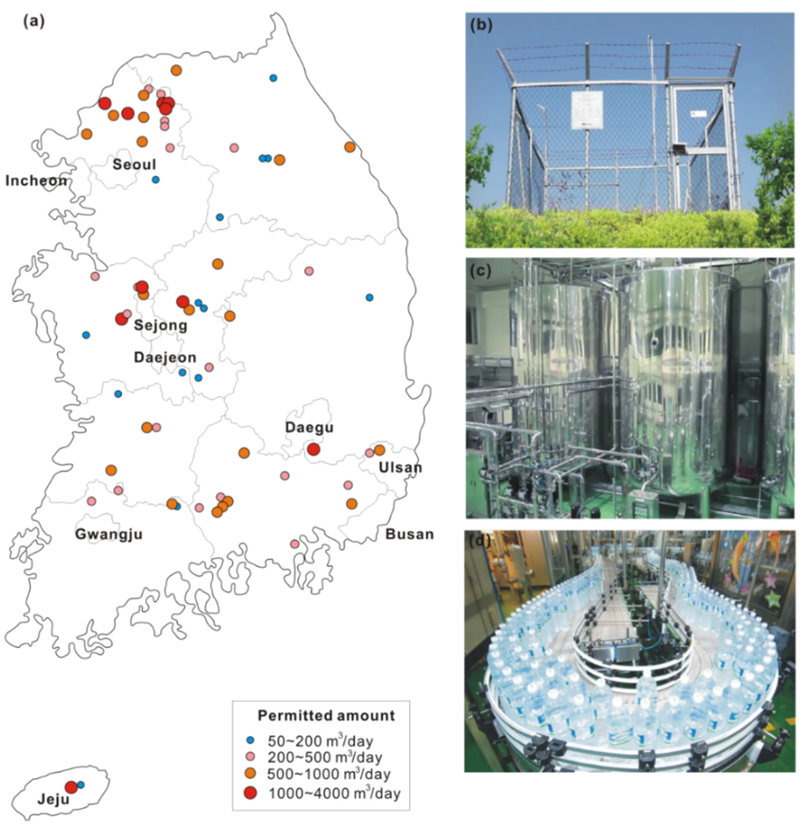
Commercial bottled water all originates from groundwater because sales of bottled waters from surface (river) water are strictly prohibited in Korea by the relevant laws. Since the first permit by the ME for commercial sales of bottled water in 1995, the sales market increased from 72.6 million (M) US dollars in 1995 to 334.7 M dollars in 2010 [47]. With the growing market, the number of bottling companies has increased from three to sixty five over the last twenty years (Figure 7a). Each company is permitted to extract groundwater ranging from 60 to 3700 m3/day with a mean of 600 m3/day [48]. Each company has one to eight production wells with a mean of three (Figure 7b), which means an average groundwater pumping of 200 m3/day per production well. Figure 7c,d show a physical treatment system of withdrawn groundwater using sand filters and an automatic bottling line used in bottled water companies.
According to the Drinking Water Management Act (Article 22.1) and Enforcement Regulation (Article 12.1), the bottled water companies must conduct monitoring of groundwater level, withdrawal rate, EC, water temperature, and pH with automatic sensors every hour for each production well. The measuring sensors should be calibrated every six months. Every month, they also have to submit the monitoring data to the central and/or local government in charge. Besides the physical condition of the groundwater, water quality is also strictly controlled by the ME as bottled water consumption keeps increasing [49]. The bottled water companies are required to conduct water quality analysis: for bottled water, a 51 parameter water analysis including uranium level is performed at least every three months; for the raw groundwater in the production well, a 47 parameter analysis is conducted every year. All the water quality analysis results are reported to the city or central government and then finally to the ME.
Currently, more than 196 production wells operated by 65 companies (as of 2015) report the monitoring data to the ME. Unlike with other Monitoring Networks, however, the data are not available to the public under the DWMN because the production wells are private properties. Large production wells are located mostly in the vicinity of metropolitan cities like Seoul (see Figure 7a), a result of the intention to reduce the transportation cost. Civil complaints against the bottled water companies are increasing with the concern of groundwater depletion (drying wells) due to their production wells. The monitoring data should be transparent in order to evaluate the influence of upgradient pumping, but this requires a revision of several related laws [3].
4. Conclusions
We have summarized the six main groundwater monitoring networks currently operated in Korea. Most groundwater monitoring tasks are automatically operated thanks to the fast development of information technology. Monitoring data are available to the public in real time which is also benefited by the governmental information policy (Government 3.0). When the land area (99,720 km2) of Korea is considered, the high monitoring-well density of 0.035 wells/km2 [50] proves the nation’s diligent effort to secure groundwater resources. However, issues and problems exist that need to be addressed to improve the current groundwater management system:
- An integrated and comprehensive law is absent that can deal with overall groundwater affairs. At present, several laws and ministries are associated with the same groundwater resource but with their own distinct purposes and limited cooperation. When a groundwater quality issue is perceived by a ministry while conducting its inherent duties, it does not take appropriate measures if the ministry has only authority to deal with groundwater availability (i.e., water level decline or depletion). A comprehensive law is required to manage groundwater affairs in an integrated manner.
- Unified manuals are necessary for the installation of monitoring wells. Each monitoring network has its own specifications for monitoring wells. Different probes are used with different resolutions; the monitoring data have different formats with different communication protocols, and thus it takes an unnecessarily long time to convert each network data to make them comparable with other network data.
- Ministries and affiliated agencies lack communication with each other. Each ministry develops a Monitoring Network for its own purposes almost independently, without sharing enough information with other ministries as to the well locations, well specifications, and monitoring devices. Often monitoring wells, each of which is operated by a different ministry, happen to be located very close to each other and annual reports published by different ministries contain redundant data. This current practice raises a sustainability issue for the overall monitoring system. Holistic approaches among different ministries and agencies are required to secure the groundwater resources of the country.
- Active participation and feedback from the public are missing in the current monitoring system. The data from the various Monitoring Networks are used mainly for administrative purposes and/or academic research, and in general, the public are not involved in planning the Networks. With growing concern regarding water resources and the effects of a changing climate on the public health and life style, the public should participate in the sustainable groundwater management system from the design step of Monitoring Networks to the operation step.
- Intensive and extensive reviews on the current number of monitoring wells, sampling frequency and position are immediately required. In addition, monitoring wells addressing other important issues including groundwater-surface water interaction [51], capture zone [52] and groundwater age [53,54] should be considered.
Acknowledgments
This work was supported by the National Research Foundation of Korea (NRF) grant funded by the Korean Government (MSIP) (No. NRF-2015R1A4A1041105). We are very thankful to Chris Daughney at GNS and two anonymous reviewers for their helpful comments that improved the initial manuscript.
Author Contributions
As the lead author, Jin-Yong Lee conceived the paper, analyzed the data, prepared the tables and the figures, and wrote the paper. Kideok D. Kwon wrote the paper.
Conflicts of Interest
The authors declare no conflict of interest.
References
- Chung, I.M.; Kim, J.; Lee, J.; Chang, S.W. Status of exploitable groundwater estimation in Korea. J. Eng. Geol. 2015, 25, 403–412. [Google Scholar] [CrossRef]
- Won, K.S.; Chung, S.Y.; Lee, C.S.; Jeong, J.H. Replacement of saline water through injecting fresh water into a confined saline aquifer at the Nakdong River delta area. J. Eng. Geol. 2015, 25, 215–225. [Google Scholar] [CrossRef]
- Lee, J.Y. Lessons learned from three groundwater disputes in Korea: Lack of comprehensive and integrated investigation. Int. J. Water 2016, in press. [Google Scholar]
- Lee, J.Y.; Kwon, K. Groundwater resources in Gangwon Province: Tasks and perspectives responding to droughts. J. Geol. Soc. Korea 2015, 51, 585–595. [Google Scholar] [CrossRef]
- Jung, K.; Lee, T.; Choi, B.G.; Hong, S. Rainwater harvesting system for continuous water supply to the regions with high seasonal rainfall variations. Water Resour. Manag. 2015, 29, 961–972. [Google Scholar] [CrossRef]
- Kim, D.; Amy, G.L.; Karanfil, T. Disinfection by-product formation during seawater desalination: A review. Water Res. 2015, 81, 343–355. [Google Scholar] [CrossRef] [PubMed]
- Nam, W.H.; Hayes, M.J.; Svoboda, M.D.; Tadesse, T.; Wilhite, D. Drought hazard assessment in the context of climate change for South Korea. Agric. Water Manag. 2015, 160, 106–117. [Google Scholar] [CrossRef]
- Byun, H.R. Drought in 2016: Perspective and measures. In Proceedings of the Chuncheon International Water Forum, Chuncheon, Korea, 20 October 2015; pp. 9–21.
- Lee, J.Y.; Yi, M.J.; Yoo, Y.K.; Ahn, K.H.; Kim, G.B.; Won, J.H. A review of the National Groundwater Monitoring Network in Korea. Hydrol. Process. 2007, 21, 907–919. [Google Scholar] [CrossRef]
- Lee, J.Y. Challenges of groundwater as resources in the near future. J. Soil Groundw. Environ. 2015, 20, 1–9. [Google Scholar] [CrossRef]
- Jung, C.D.; Kim, Y.B.; Park, K.Y.; Park, S.J. Efficient management method of groundwater in farming and fishing villages. J. Soil Groundw. Environ. 2012, 17, 81–90. [Google Scholar] [CrossRef]
- Won, J.H.; Lee, J.Y.; Kim, J.W.; Koh, G.W. Groundwater occurrence on Jeju Island, Korea. Hydrogeol. J. 2006, 14, 532–547. [Google Scholar] [CrossRef]
- Lee, J.Y. Environmental issues of groundwater in Korea: Implications for sustainable use. Environ. Conserv. 2011, 38, 64–74. [Google Scholar] [CrossRef]
- Baek, W.; Lee, J.Y. Source apportionment of trichloroethylene in groundwater of an industrial complex in Korea: A 15-year dispute and perspective. Water Environ. J. 2011, 25, 336–344. [Google Scholar] [CrossRef]
- Choi, H.M.; Lee, J.Y. Groundwater contamination and natural attenuation capacity at a petroleum spilled facility in Korea. J. Environ. Sci. 2011, 23, 1650–1659. [Google Scholar] [CrossRef]
- Lee, J.Y.; Yi, M.J.; Moon, S.H.; Cho, M.; Lee, J.M.; Ahn, K.H.; Won, J.H. Causes of the changes in groundwater levels at Daegu, Korea: The effect of subway excavations. Bull. Eng. Geol. Environ. 2007, 66, 251–258. [Google Scholar] [CrossRef]
- Kim, N.J.; Cho, M.J.; Woo, N.C. Developing a national groundwater monitoring network in Korea. Hydrogeol. J. 1995, 3, 89–94. [Google Scholar] [CrossRef]
- Ministry of Land, Transport and Maritime Affairs. National Basic Plan for Groundwater Management (2012–2021); MLTMA: Sejong, Korea, 2012. [Google Scholar]
- Shim, S.B.; Oh, S.G.; Chun, Y.J. The study of development skin improvement cosmetic by spring water of Onyang. J. Korea Acad. Ind. Coop. Soc. 2011, 12, 4257–4260. [Google Scholar] [CrossRef]
- Lee, C.W.; Moon, S.H.; Kim, H.C. The evaluation of daily safe yield and influence of hot spring wells. J. Soil Groundw. Environ. 2006, 11, 41–47. [Google Scholar]
- Ministry of Interior. Hot Spring Management with Peoples. Available online: http://www.mogaha.go.kr/frt/sub/a06/b06/hotSpringMgr/screen.do (accessed on 20 April 2016).
- Lee, J.I.; Yang, H.S. A study on the prosperity of hot spring industry using healthy hot spring. J. Korea Acad. Ind. Coop. Soc. 2008, 9, 1467–1478. [Google Scholar] [CrossRef]
- Korea Hotspring Association. Investigation and Analysis on Status of Hot Spring Resources in Unplanned Development Areas; MPAS: Seoul, Korea, 2008. [Google Scholar]
- Hagedorn, B.; El-Kadi, A.I.; Mair, A.; Whittier, R.B.; Ha, K. Estimating recharge in fractured aquifers of a temperate humid to semiarid volcanic island (Jeju, Korea) from water table fluctuations, and Cl, CFC-12 and 3H chemistry. J. Hydrol. 2011, 409, 650–662. [Google Scholar] [CrossRef]
- Lee, J.Y. Comment on “Groundwater monitoring in Denmark: Characteristics, perspectives and comparison with other countries”. Hydrogeol. J. 2010, 18, 803–804. [Google Scholar]
- Kim, G.B. Optimal distribution of groundwater monitoring wells near the river barrages of the 4MRRP using a numerical model and topographic analysis. Environ. Earth Sci. 2015, 73, 5497–5511. [Google Scholar] [CrossRef]
- Park, Y.C.; Jo, Y.J.; Lee, J.Y. Trends of groundwater data from the Korean National Groundwater Monitoring Stations: indication of any change? Geosci. J. 2011, 15, 105–114. [Google Scholar] [CrossRef]
- Lee, B.; Hamm, S.Y.; Jang, S.; Cheong, J.Y.; Kim, G.B. Relationship between groundwater and climate change in South Korea. Geosci. J. 2014, 18, 209–218. [Google Scholar] [CrossRef]
- Park, J.K.; Kim, R.H.; Lee, J.Y.; Choi, D.H.; Kim, T.D. Evaluation of status of groundwater quality monitoring network of Korea: Implications for improvement. J. Soil Groundw. Environ. 2007, 12, 92–99. [Google Scholar]
- Ministry of Environment (ME). 2012 Operation Results of Groundwater Quality Monitoring Network; ME: Sejong, Korea, 2013. [Google Scholar]
- Yun, S.W.; Choi, H.M.; Lee, J.Y. Comparison of groundwater levels and groundwater qualities in six megacities of Korea. J. Geol. Soc. Korea 2014, 50, 517–528. [Google Scholar] [CrossRef]
- Lee, J.Y.; Song, S.H. Evaluation of groundwater quality in coastal areas: Implications for sustainable agriculture. Environ. Geol. 2007, 52, 1231–1242. [Google Scholar] [CrossRef]
- Park, S.C.; Yun, S.T.; Chae, G.T.; Yoo, I.S.; Shin, K.S.; Heo, C.H.; Lee, S.K. Regional hydrochemical study on salinization of coastal aquifers, western coastal area of South Korea. J. Hydrol. 2005, 313, 182–194. [Google Scholar] [CrossRef]
- 2014 Seawater Intrusion Survey Report; Korea Rural Community Corporation (KRC): Uiwang, Korea, 2014.
- Song, S.H.; Lee, J.Y.; Yi, M.J. Evaluation of long-term data obtained from seawater intrusion monitoring network using variation type analysis. J. Korea Earth Sci. Soc. 2007, 28, 478–490. [Google Scholar] [CrossRef]
- Song, S.H.; Lee, J.Y.; Park, N.S. Use of vertical electrical soundings to delineate seawater intrusion in a coastal area of Byunsan, Korea. Environ. Geol. 2007, 52, 1207–1219. [Google Scholar] [CrossRef]
- Park, Y.; Lee, J.Y.; Kim, J.H.; Song, S.H. National scale evaluation of groundwater chemistry in Korea coastal aquifers: Evidences of seawater intrusion. Environ. Earth Sci. 2012, 66, 707–718. [Google Scholar] [CrossRef]
- Kim, K.H.; Shin, J.Y.; Koh, E.H.; Koh, G.W.; Lee, K.K. Sea level rise around Jeju Island due to global warming and movement of groundwater/seawater interface in the eastern part of Jeju Island. J. Soil Groundw. Environ. 2009, 14, 68–79. [Google Scholar]
- 2014 Report on Rural Groundwater Management Monitoring Network; Korea Rural Community Corporation (KRC): Uiwang, Korea, 2014.
- Lee, B.S.; Kim, Y.I.; Choi, K.J.; Song, S.H.; Kim, J.H.; Woo, D.K.; Seol, M.K.; Park, K.Y. Rural groundwater monitoring network in Korea. J. Soil Groundw. Environ. 2014, 19, 1–11. (In Korean) [Google Scholar] [CrossRef]
- Lee, J.Y.; Song, S.H. Groundwater chemistry and ionic ratios in a western coastal aquifer of Buan, Korea. Geosci. J. 2007, 11, 259–270. [Google Scholar] [CrossRef]
- Method of Reporting Operation Result of Subsidiary Groundwater Monitoring Network and Voluntary Declaration on Illegal Groundwater Facilities; Ministry of Land, Infrastructure and Transport (MOLIT): Sejong, Korea, 2015.
- Kim, J.W.; Lee, J.Y.; Yi, M.J.; Kim, G.B.; Won, J.H.; Lee, K.K. Allocating local groundwater monitoring stations for South Korea using an analytic hierarchy process. Hydrogeol. J. 2007, 15, 615–632. [Google Scholar] [CrossRef]
- Lee, J.Y.; Lee, G.S.; Song, S.H. An interpretation of changes in groundwater level and electrical conductivity in monitoring wells in Jeju Island. J. KoreaEarth Sci. Soc. 2007, 28, 925–935. [Google Scholar]
- Choi, H.M.; Lee, J.Y. Parametric and non-parametric trend analyses for water levels of groundwater monitoring wells in Jeju Island. J. Soil Groundw. Environ. 2009, 14, 41–50. [Google Scholar]
- Unno, T.; Kim, J.; Kim, Y.; Nguyen, S.G.; Guevarra, R.B.; Kim, G.P.; Lee, J.H.; Sadowsky, M.J. Influence of seawater intrusion on microbial communities in groundwater. Sci. Total Environ. 2015, 532, 337–343. [Google Scholar] [CrossRef] [PubMed]
- A Study on Plan for Characterizing Drinking Groundwater; Korea Institute of Geoscience and Mineral Resources (KIGAM): Sejong, Korea, 2011.
- National Institute of Environmental Research (NIER). Soil and Groundwater Information System. Available online: http://sgis.nier.go.kr (accessed on 17 February 2016).
- Lee, J.Y.; Park, Y.; Kim, N.J.; Jeon, W.H. Status of community drinking water in Korea and implications for appropriate management. J. Soil Groundw. Environ. 2013, 18, 56–68. [Google Scholar] [CrossRef]
- Plan of Installation of Groundwater Quality Monitoring Network and Measurement of Groundwater Pollution Status; Ministry of Environment (ME): Sejong, Korea, 2014.
- Donath, F.M.; Daughney, C.J.; Morgenstern, U.; Cameron, S.G.; Toews, M.W. Hydrochemical interpretation of groundwater-surface water interactions at catchment and local scales, Lake Rotorua catchment, New Zealand. J. Hydrol. N. Z. 2015, 54, 11–32. [Google Scholar]
- Moreau, M.; Cameron, S.G.; Daughney, C.J.; Gusyev, M.A.; Tschritter, C. Envirolink Tools Project: Capture Zone Delineation; GNS Science: Lower Hutt, New Zealand, 2013. [Google Scholar]
- Moreau, M.; Daughney, C.J.; Morgenstern, U.; van der Raaij, R.; Reeves, R.R. Discriminant analysis for estimation of groundwater age from hydrochemistry and well construction: Application to New Zealand aquifers. Hydrogeol. J. 2010, 18, 417–428. [Google Scholar]
- Morgenstern, U.; Daughney, C.J. Groundwater age for identification of baseline groundwater quality and the impacts of land-use intensification-The National Groundwater Monitoring Programme of New Zealand. J. Hydrol. 2012, 456, 79–93. [Google Scholar] [CrossRef]
Figure 1.
Location of the Republic of Korea and its simplified geologic map (modified from [3]).
Figure 1.
Location of the Republic of Korea and its simplified geologic map (modified from [3]).

Figure 2.
(a) Number of groundwater wells installed and total amount of groundwater use in Korea for 1996–2013; and (b) amount of water use by agriculture, domestic, and industry. Data are from the National Groundwater Information Center (www.gims.go.kr).
Figure 2.
(a) Number of groundwater wells installed and total amount of groundwater use in Korea for 1996–2013; and (b) amount of water use by agriculture, domestic, and industry. Data are from the National Groundwater Information Center (www.gims.go.kr).

Figure 3.
Distribution of the National Groundwater Monitoring Stations (wells). (a) scenes of the stations; (b) scenes with cover house and (c) scenes without cover house; and (d) webpage screenshot (www.gims.go.kr) showing the operational status of all stations and the real time monitoring data.
Figure 3.
Distribution of the National Groundwater Monitoring Stations (wells). (a) scenes of the stations; (b) scenes with cover house and (c) scenes without cover house; and (d) webpage screenshot (www.gims.go.kr) showing the operational status of all stations and the real time monitoring data.
Figure 4.
(a) Structure of the Groundwater Quality Monitoring Network (GQMN) of Korea; (b) location of the exclusive monitoring wells with different depths (18, 36, 80 m); and (c) webpage screenshot (sgis.nier.go.kr) showing the monitoring results for groundwater quality.
Figure 4.
(a) Structure of the Groundwater Quality Monitoring Network (GQMN) of Korea; (b) location of the exclusive monitoring wells with different depths (18, 36, 80 m); and (c) webpage screenshot (sgis.nier.go.kr) showing the monitoring results for groundwater quality.
Figure 5.
(a) Locations of the Seawater Intrusion Monitoring Network (SIMN) wells and the Rural Groundwater Monitoring Network (RGMN) wells; (b) scene of the seawater intrusion monitoring station; (c) scene of the rural groundwater monitoring well; and (d) webpage screenshot (www.groundwater.or.kr) showing the results of the two groundwater monitoring networks.
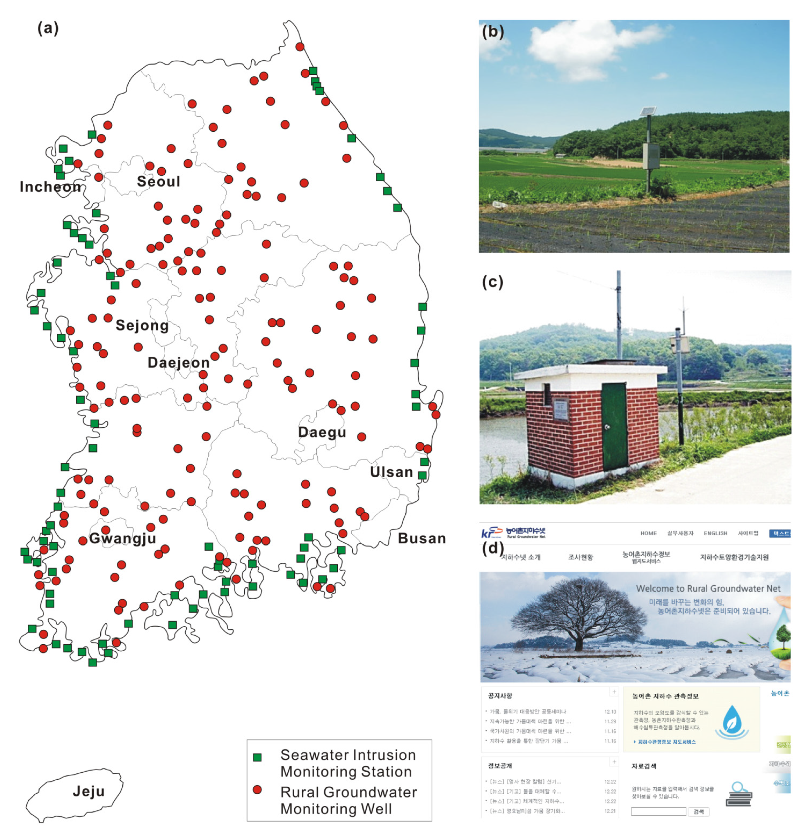
Figure 6.
(a) Distribution of local groundwater monitoring wells in Jeju volcanic island; (b) scene of the monitoring well; and (c) webpage screenshot (www.jejuwater.go.kr) showing the real time monitoring data on an hourly basis.
Figure 6.
(a) Distribution of local groundwater monitoring wells in Jeju volcanic island; (b) scene of the monitoring well; and (c) webpage screenshot (www.jejuwater.go.kr) showing the real time monitoring data on an hourly basis.
Figure 7.
(a) Distribution of groundwater wells used for manufacturing bottled drinking water with permitted withdrawal amount [48]; (b) one of the pumping wells; (c) physical filtration process for pumped groundwater; and (d) automated bottling line facility.
Figure 7.
(a) Distribution of groundwater wells used for manufacturing bottled drinking water with permitted withdrawal amount [48]; (b) one of the pumping wells; (c) physical filtration process for pumped groundwater; and (d) automated bottling line facility.


| Laws | Objects | Enactments | Jurisdictions |
|---|---|---|---|
| Groundwater Act | All except the groundwater that the other Acts control | 10 December 1993 | Ministry of Land, Infrastructure and Transport (MOLIT); Ministry of Environment (ME) |
| Hot Spring Act | Hot spring water (groundwater over 25 °C) | 2 Mary 1981 | Ministry of The Interior (MOI) |
| Drinking Water Management Act | Drinking groundwater (spring water) | 5 January 1995 | ME |
| Rearrangement of Agricultural and Fishing Villages Act | Groundwater used for agriculture | 22 December 1994 | Ministry of Agriculture, Food and Rural Affairs (MAFRA) |
| Act on National Defense and Military Installations Projects | Groundwater facilities for military affairs | 14 January 1991 | Ministry of National Defense (MND) |
| Framework Act on Civil Defense | Groundwater facilities for national emergency (e.g., war, disasters) | 25 July 1975 | Ministry of Public Safety and Security (MPSS) |
| Special Act on The Establishment of Jeju Special Self-Governing Province and The Development of Free International City | All groundwater on Jeju Island (Province) | 21 February 2006 | MOI; MOLIT |
| Networks | Parameters | No. of Wells | Operations |
|---|---|---|---|
| National Groundwater Monitoring Network (NGMN) | water level, water temperature, EC | 552 (386 deep + 166 shallow, as of December 2015) | MOLIT and K-water |
| Groundwater Quality Monitoring Network (GQMN) | ~0 parameters including pH, EC, NO3−, Cl−, As | 3141 (as of December 2014) | ME and Korea Environment Corporation |
| Seawater Intrusion Monitoring Network (SIMN) | water level, water temperature, EC, and major ions | 145 (as of December 2014) | MAFRA and KRC |
| Rural Groundwater Monitoring Network (RGMN) | water level, water temperature, EC | 176 (as of December 2014) | MAFRA and KRC |
| Subsidiary or Local Groundwater Monitoring Network (SGMN or LGMN) | water level | 1803 (as of September 2015) | Local governments (city and county) |
| Drinking Water (groundwater) Monitoring Network (DWMN) | water level, water temperature, EC, Water quality | 189 (as of February 2013) | ME and commercial bottled groundwater companies |
| Constituting Networks | Monitoring Parameters | No. of Wells | Frequency |
|---|---|---|---|
| exclusive network for monitoring groundwater quality | 67 parameters including basic parameters and drinking water standards parameters | 508 | 4 times per year |
| NGMN | 19 groundwater quality standards parameters for living use and EC | 552 (386 deep + 166 shallow) | 2 times per year |
| RGMN | 19 groundwater quality standards parameters for living use and EC | 60 | 2 times per year |
| local groundwater quality monitoring network | 19 groundwater quality standards parameters for living use and EC | 2021 | 2 times per year |
Table 4.
Current status of subsidiary/local groundwater monitoring wells in Korea [42]. RTU = remote terminal unit.
| City/Province | Total | Type of Wells | Monitoring Methods | |||
|---|---|---|---|---|---|---|
| Monitoring Only | Using Well | Automatic (with RTU) | Semi-Auto (No RTU) | Manual | ||
| Seoul | 214 | 18 | 196 | 114 | 56 | 44 |
| Busan | 189 | 18 | 171 | 132 | 48 | 9 |
| Daegu | 136 | – | 136 | – | – | 136 |
| Incheon | – | – | – | – | – | – |
| Gwangju | – | – | – | – | – | – |
| Daejeon | 39 | – | 39 | 15 | 24 | – |
| Ulsan | 36 | – | 36 | 9 | – | 27 |
| Sejong | 3 | 3 | – | 3 | – | – |
| Gyeonggi | 144 | 66 | 78 | 61 | 26 | 57 |
| Gangwon | 46 | 28 | 18 | 37 | – | 9 |
| Chungbuk | 308 | 240 | 68 | 308 | – | – |
| Chungnam | 167 | 155 | 12 | 40 | 21 | 106 |
| Jeonbuk | 6 | 6 | – | – | – | 6 |
| Jeonnam | 10 | 4 | 6 | 5 | – | 5 |
| Gyeongbuk | 12 | 2 | 10 | 2 | – | 10 |
| Gyeongnam | 493 | 111 | 382 | 370 | 91 | 32 |
| Subtotal | 1803 | 651 | 1152 | 1096 | 266 | 441 |
| Jeju | 132 | 132 | – | 132 | – | – |
© 2016 by the authors; licensee MDPI, Basel, Switzerland. This article is an open access article distributed under the terms and conditions of the Creative Commons Attribution (CC-BY) license (http://creativecommons.org/licenses/by/4.0/).
Share and Cite
MDPI and ACS Style
Lee, J.-Y.; Kwon, K.D. Current Status of Groundwater Monitoring Networks in Korea. Water 2016, 8, 168. https://doi.org/10.3390/w8040168
AMA Style
Lee J-Y, Kwon KD. Current Status of Groundwater Monitoring Networks in Korea. Water. 2016; 8(4):168. https://doi.org/10.3390/w8040168
Chicago/Turabian StyleLee, Jin-Yong, and Kideok D. Kwon. 2016. "Current Status of Groundwater Monitoring Networks in Korea" Water 8, no. 4: 168. https://doi.org/10.3390/w8040168
Note that from the first issue of 2016, this journal uses article numbers instead of page numbers. See further details here.