Article

Scenario Planning to Address Critical Uncertainties for Robust and Resilient Water–Wastewater Infrastructures under Conditions of Water Scarcity and Rapid Development

by
Christopher A. Scott
1,2,*,
Christopher J. Bailey
1,3,
Ralph P. Marra
4,
Gwendolyn J. Woods
5,
Kerri Jean Ormerod
2 and
Kevin Lansey
6
1
Udall Center for Studies in Public Policy, The University of Arizona, 803 East 1st Street, Tucson, AZ 85719, USA
2
School of Geography & Development, The University of Arizona, P.O. Box 210076, Tucson, AZ 85721, USA
3
School of Landscape Architecture and Planning, The University of Arizona, 803 East 1st Street, Tucson, AZ 85719, USA
4
SouthWest Water Resources Consulting, LLC, 2511 East 8th Street, Tucson, AZ 85716, USA
5
Department of Chemical and Environmental Engineering, The University of Arizona, 1133 East James E. Rogers Way, Harshbarger 108, Tucson, AZ 85721, USA
6
Department of Civil Engineering and Engineering Mechanics, The University of Arizona, PO Box 210072, Tucson, AZ 85721, USA
*
Author to whom correspondence should be addressed.
Water 2012, 4(4), 848-868; https://doi.org/10.3390/w4040848
Submission received: 13 September 2012 / Revised: 9 October 2012 / Accepted: 29 October 2012 / Published: 5 November 2012
(This article belongs to the Special Issue Sustainable Water Systems)

Abstract

:
Ensuring water availability for multiple needs represents a sustainable development challenge globally. Rigid planning for fixed water supply and reuse targets with estimated demand growth and static assumptions of water availability can prove inflexible in responding to changing conditions. Formal methods to adaptively respond to these challenges are needed, particularly in regions with limited natural resources and/or where multiple uncertain forces can influence water-resource availability and supply reliability. This paper assesses the application of Scenario Planning in one such region—Tucson, Arizona, USA—over the coming 40 years, and highlights broader lessons for addressing complex interrelationships of water management, infrastructure development, and population growth. Planners from multiple jurisdictions and researchers identified ten key forces and prioritized three with the greatest uncertainty and the greatest impact for water and development planning: (1) changing demands based on potential future density, layout, and per capita water use/reuse; (2) adequacy of current water supplies to meet future demands; and (3) evolving public perceptions of water reuse including potential options to supplement potable water supplies. Detailed scenario modeling using GIS and infrastructure cost optimization is under development and is now beginning to produce results, to be discussed in future publications. The process has clearly demonstrated the value of Scenario Planning as a tool for bringing stakeholders into agreement over highly complex and historically divisive problems, and for prioritizing amongst diverse uncertainties. The paper concludes by characterizing possible outcomes for this case and draws lessons for other water scarce regions experiencing rapid development.

1. Introduction

1.1. Context

Water supply, sanitation, and associated public health and environmental quality are integral to sustainable development for all [1]. Management objectives for water and wastewater are centered on maintaining and improving the quality of service and addressing changes in supply and demand. In the short and medium terms, water supply variability responds to hydrological processes and to other human and environmental uses of water at the resource level of river basins and aquifers. Climate change is increasingly recognized as a major driver of longer-term water supply uncertainty [2]. While hydroclimatic processes also change water consumption, perhaps the more important influences on demand are social and institutional in nature, such as demographic change, the spatial pattern and density of urban development, water use and conservation practices, water pricing, and regulations. Added to these, as will be shown in this paper, public acceptance of potential water use and reuse plans will play an increasingly important role, especially where citizens actively participate in planning and management [3].
Of the various interrelated factors outlined above that affect water and reuse planning, each in its own right exerts influence on water supply reliability. However, in combination they represent a formidable mix of uncertain impacts that operate over varying spatial and temporal scales. For instance, how might climate-driven water scarcity at the river basin level affect infrastructure operations and thereby local costs and rates for service delivery? How would water rates, in turn, influence demand? Would public perception and user practice of watering outdoor vegetation influence planning for water recycling? And these do not address the “unknown unknowns”, which are factors that may present themselves in the future and whose influences are not understood even if they were currently identifiable. Decision-makers—that is, water managers, planners, political leaders, citizens’ groups, researchers, and others—often find such complexity overwhelming and may even avoid or reject the need to account for the many potential factors in planning. Tools are thus needed that address uncertainty via a structured process that makes use of available and potential new sources of information while incorporating multiple perspectives of diverse stakeholders.
It has long been recognized (see especially Schwartz [4]), that varying future conditions and planning options to address such issues may be resolved using scenario analysis. Conventionally, the construction and analysis of scenarios entails identifying multiple “what if” conditions that capture a credible range of possible trajectories for physical and/or institutional processes. Often, simulation models and decision support systems are created to project potential outcomes over time. Increasingly sophisticated physical simulation models and some agent-based models provide planners the ability to more robustly consider future conditions and decision-making responses. Such models are limited in their ability to account for the complex set of real-world factors that can influence the particular set of conditions under consideration. To address complexity, integrated assessment models have been developed [5] that seek to capture the effects of disparate processes and those that operate over broader spatial and temporal scales.
While much progress has been made in harmonizing the interface between modeling and policymaking, two broad categories of uncertainty continue to challenge scenario assessment: (1) process uncertainty and (2) model uncertainty. Process uncertainty refers to the complexity problem mentioned above, e.g., what effects will climate, ecological, or institutional dynamics have on water resource availability? This is often addressed using statistical techniques to capture stochastic variability in probabilistic rather than deterministic terms. In other words, bounds of probability for key processes are considered. These may be resolved for decision-making purposes as high, medium, and low levels of the variable in question. An alternate approach is to consider business-as-usual compared to a set of options that seek to integrate multiple planning variables. Model uncertainty is often addressed through the application of a suite of models, for example, multiple general circulation models used by the Intergovernmental Panel on Climate Change. Responses to both process and model uncertainty have sought to improve the use of information. Despite increasing model complexity and improved information flows, less attention has been paid to how decision-making accounts for uncertainty itself. The interactive stakeholder-based process described here highlights the need to address those variables which exhibit the greatest uncertainty, and which in turn, can exert the greatest influence on decision-making outcomes.
This paper contributes to the Water special issue on “Sustainable Water Systems” by: (a) advancing conceptual approaches to water and wastewater planning under uncertainty; (b) presenting ongoing experience with the applied technique known as Scenario Planning [4]; and (c) describing a specific case study that illustrates conceptual and applied considerations, especially through the use of optimization modeling to produce infrastructure results under scenarios that reflect what stakeholders believe are the critical uncertainties for sustainable urban water management. “Scenario Planning is a systematic method for thinking creatively about possible complex and uncertain futures. The central idea of Scenario Planning is to consider a variety of possible futures that include many of the important uncertainties in the system rather than to focus on the accurate prediction of a single outcome” [6]. Aiming to address in a robust manner the important uncertainties by including qualitative and quantitative understandings, Scenario Planning begins with a specific management issue and creates a structured account of a range of possible futures, or future transformation with respect to the given management issue. Based on unique combinations of possible futures, the process provides flexibility in planning by offering a range of options with various degrees of similarity and overlapping common elements. Scenario Planning is also a tool for engaging diverse stakeholders and maintaining engagement despite disagreements over even relatively central issues. This approach builds on work by van der Heijden [7]. Relevant and related studies have been described by Kok et al. [8] and Gleeson et al. [9].
Figure 1 illustrates the way in which Peterson et al. [6] view the suitability of planning/management methods under different combinations of uncertainty and controllability. In the case study described below, uncertainty is high but controllability (particularly of growth and demand patterns) is low, necessitating Scenario Planning in favor of an approach based purely on adaptive management. In adaptive management, rather than focusing upon a course of action that is intended to be successful in all possible futures (but may also be sub-optimal in all or many possible futures), actions are taken that may involve a greater degree of risk, with the intention of learning from and correcting for failures. Pahl-Wostl et al. [10], however, pertinently observe that “large-scale infrastructure with a life-span of decades provides few opportunities for learning and may easily lead to lock-in situations… Adaptive management is mainly limited to the operational level.” Hedging seeks to reduce sensitivity to uncertainty by taking actions that will pay off in the same circumstances in which another action (also taken) fails, which essentially guarantees regret costs with their associated negative public reaction. Optimal control has long been the default for many infrastructure planning decisions, and assumes a future certain enough that a system can be safely optimized for a single scenario. However, as Milly et al. [2] observed, future climatic processes now appear to be subject to previously nonexistent or insignificant forces of change and cannot be predicted from past trends.
Figure 1. Applicability of planning approaches (adapted from Peterson et al. [6]).
Water 04 00848 g001
Also important to the suitability of a planning approach is the degree to which the relevant problems have “structure” [11]. Highly structured problems, where decisions can be made using rules or algorithms, are limited in scope and lend themselves to hedging and optimization strategies. As structure decreases, the potential inputs, interconnectedness, and range of future possibilities will tend to increase, raising the need for adaptive management or Scenario Planning approaches.
Based on the conceptual approach outlined here, this paper is organized as follows. This introductory section has highlighted the role of scenarios in accounting for multiple development trajectories and has addressed the crucial importance of uncertainty in decision-making. The responses of different planning methods in conditions of high uncertainty and low controllability make Scenario Planning especially applicable to the Arizona, USA case of water and wastewater planning addressed in the next section. Here, the focus lies on the application of Scenario Planning in addressing three critical planning forces, prioritized among many such forces identified, through an interactive science-policy process. The subsequent section discusses the technical and institutional options of the applied Scenario Planning case, with emphasis on variable future water demand. Supply and public perception forces are described but not analyzed in detail due to lack of space. Local stakeholder priorities are discussed in such a way that generalizable lessons beyond the particular case may be learned. The concluding section broadens the assessment of multiple uncertainties and focuses on key questions raised.

1.2. The EFRI-RESIN Project

The Scenario Planning process referred to in this paper forms part of Optimization of Dual Conjunctive Water Supply and Reuse Systems with Distributed Treatment for High-Growth Water-Scarce Regions, an ongoing project supported by the Resilient and Sustainable Infrastructures (RESIN) program of the Emerging Frontiers in Research (EFRI) division of the U.S. National Science Foundation (NSF). The project aims to develop new methods for integrated water and wastewater infrastructure planning, to seek economically viable decentralized treatment and dual distribution systems, and to identify, design and evaluate water supply/wastewater treatment system configuration alternatives in the presence of complex, competing objectives and uncertainties.
Scenario Planning is used to incorporate social aspects of resilience and robustness (as defined below) into the multi-criteria, multi-stage optimization of an infrastructure system that is intended to be sustainable, resilient and robust. The goals of the EFRI-RESIN project strongly influence the Scenario Planning process being coordinated by a team within the project.
The application of Scenario Planning in this study was intended to add scholarly research to an approach that is gaining wider currency in water planning in the study region [12]. The initiative responds to broader questions on robustness, resilience, sustainability, and decision-making.

1.3. Sustainability, Robustness and Resilience

This study uses definitions of sustainability, resilience and robustness agreed on by multiple teams supported with NSF RESIN projects and to be presented soon [13]. Sustainability is defined in terms of resource and infrastructure sustainability. Resource sustainability is the ability to provide a resource of desired quantity and quality for a defined long period of time. Infrastructure sustainability is the design and operation of infrastructure systems to provide a resource at least triple-bottom-line (i.e., social, environmental, and financial) impact in terms of total built life. Within this study, economic and environmental costs are monetized (to be detailed in further work), while the Scenario Planning process described here is intended to minimize social costs such as loss of choice, regretted investment and opposition between utilities and service users. Resilience is defined as the ability to gracefully degrade and subsequently recover from a potentially catastrophic disturbance that is internal or external in origin, and robustness is defined as the ability of a system to avoid failure and maintain functionality over a large range of future conditions. By examining several scenarios that encompass a range of futures, the Scenario Planning process also aims to increase robustness by finding infrastructure designs that can perform reasonably well in all futures.

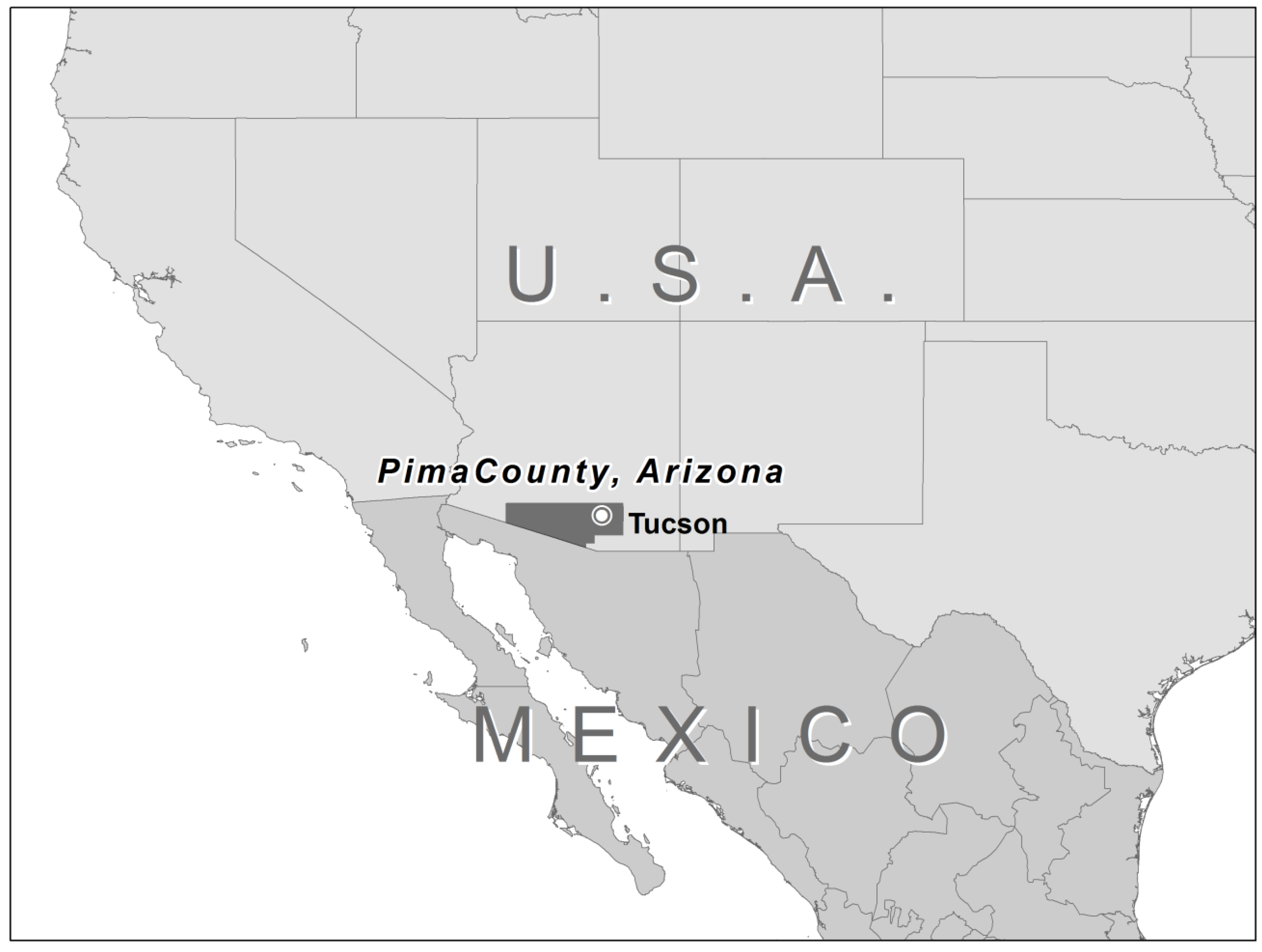
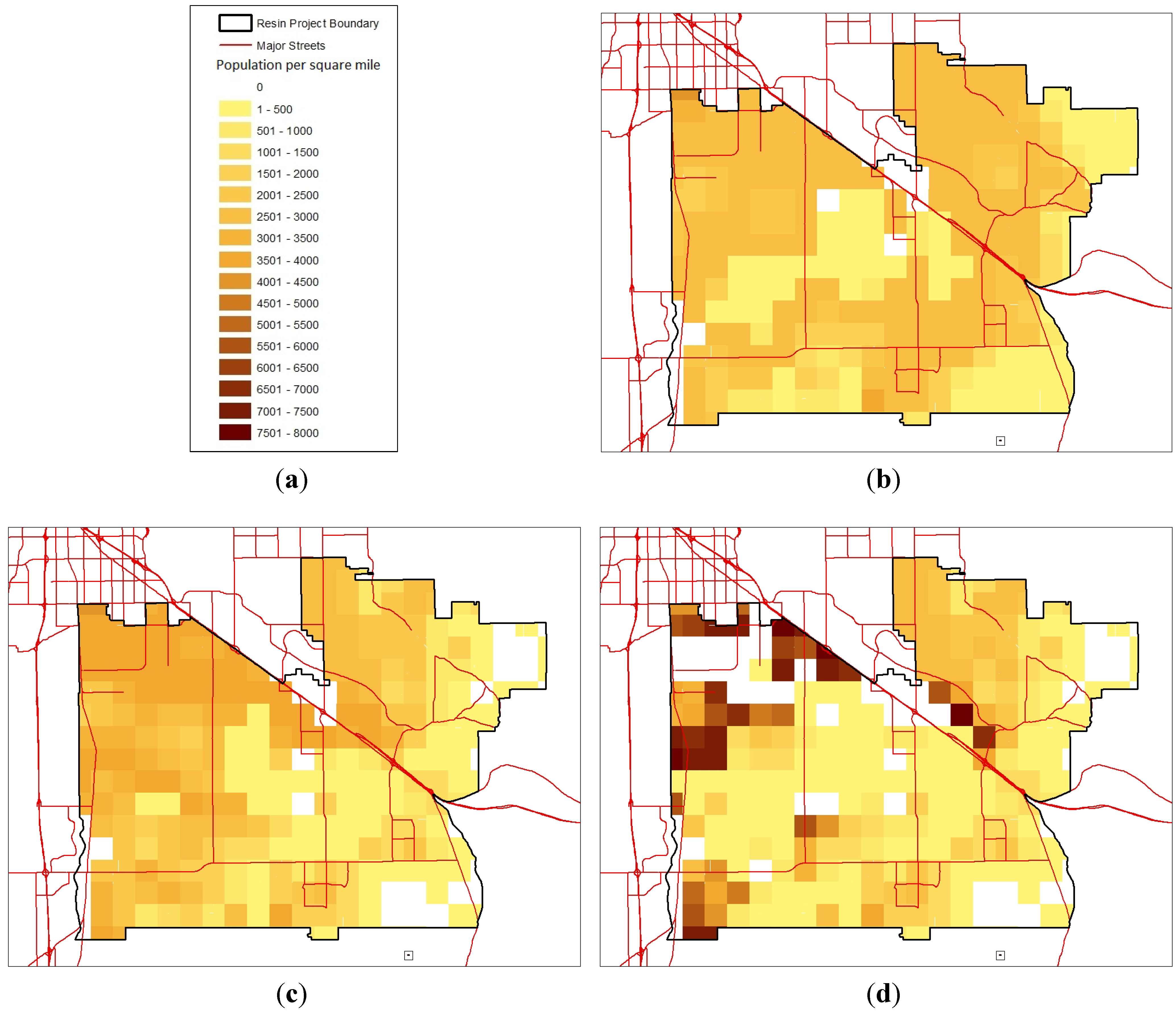
2. Water in Tucson, Pima County, Arizona

The City of Tucson, in Pima County, Arizona (Figure 2) has experienced rapid growth since the Second World War. The population of Pima County as a whole, for which Tucson is the major population center, increased 497% from 1950 to 2000, with a 2010 population of over 980,000 and an expectation of similarly rapid growth in the future [14]. Water supply, reuse, and development in Tucson and Pima County present many of the challenges that are illustrative for other water-scarce regions experiencing rapid development. The greater Tucson area, located in the Sonoran Desert region (but with relatively high total annual rainfall of 11.6 in., equivalent to 294 mm), has access to three sources of water supply: local groundwater, Colorado River water conveyed via the Central Arizona Project (CAP) aqueduct, and locally generated municipal effluent. Until recently, water users in the region relied solely on local groundwater mined from aquifer storage, and this historical practice has resulted in significant groundwater level declines and measurable land subsidence in some areas. Because continued reliance on local groundwater is unsustainable, the State of Arizona placed restrictions on agricultural and municipal groundwater use in order to achieve Safe Yield (equal or greater volumes of water recharged than withdrawn) in the greater Tucson area. The State instituted the Assured Water Supply rules, stipulating that new development requires a 100-year renewable water supply, as a lever to encourage the municipal sector to reduce its reliance on groundwater overdraft and shift to renewable supplies to meet increasing water demand associated with growth. Of the three water supplies available in the Tucson area, the State of Arizona recognizes only imported Colorado River water (i.e., CAP water) and locally generated municipal effluent as renewable supplies.
Figure 2. Location of Tucson and Pima County in Arizona, USA.
Water 04 00848 g002
The city’s water utility, Tucson Water, has the largest annual CAP water allocation in the State of Arizona, currently 177.8 million cubic meters (MCM) (144,000 acre-feet) [15] per year. CAP water is an imported supply conveyed to the area via an aqueduct and pipeline system, which delivers more than half of Arizona’s annual Colorado River water allocation over 530 km (330 miles) and which terminates in the Tucson area. Once Tucson Water and other local water utilities began utilizing CAP water, the local region’s water outlook was forced to broaden. When the Tucson area became connected with the Colorado River via the CAP, the local region of less than one million residents suddenly became linked with over 25 million other Colorado River water users in seven American states and in Mexico. From a water resources perspective, this change means that the amount of annual precipitation that occurs in the Rocky Mountains is more important than the local annual precipitation in the Tucson area. This also means that water-resource decisions made in Phoenix, Los Angeles, San Diego, Las Vegas, Denver, and Washington, DC, are potentially more important than local water decisions made in either the City of Tucson or Pima County. When it comes to water resource planning, the Tucson region is no longer local. Drought in the near- to mid-terms [16] and longer-term climate change in the Colorado River basin will increase the resource vulnerability of Colorado River water users and hence decrease the supply reliability of many large urban centers. This in turn will likely leads to future high stakes conflict as well as the potential for creative cooperation among the seven basin states and Mexico in an effort to reduce future supply uncertainties associated with expected water shortages. The Tucson area as well as the other large urban areas in Arizona will have an active interest in those future negotiations. The uncertain outcomes of those negotiations will have a bearing on how the City of Tucson will utilize its rights to withdraw local groundwater and use its effluent entitlement as well as its interest in further promoting conservation and in acquiring additional water supplies.
The City of Tucson, Pima County, the U.S. Secretary of the Interior (on behalf of the Tohono O’odham Native Nation) and other local water utilities have annual entitlements to the locally generated municipal effluent, which in 2011 represented a total of 39.5 MCM (32,000 acre-feet). The 1979 Intergovernmental Agreement between the City of Tucson and Pima County initially established the legal basis for these entitlements. Amongst other things, this agreement included a provision in which the City of Tucson gave Pima County its portion of the wastewater treatment system and the City was given 90% ownership of the effluent produced at Pima County wastewater treatment plants. Subsequent to this agreement, the Secretary of the Interior and other local water utilities also obtained annual entitlements to the locally generated effluent, but the City of Tucson continues to have the largest entitlement in the region. In an amendment to the 1979 Intergovernmental Agreement with Pima County, the Conservation Effluent Pool (CEP) was established, providing up to 12.3 MCM (10,000 acre-feet) per year for riparian/environmental enhancements. By agreement, the City of Tucson annually provides over 70% of the effluent allocated to the CEP with the balance provided by Pima County and the other local effluent entitlement holders.
In the mid-1980s, Tucson Water began recycling a portion of its effluent by constructing a non-potable reclaimed water system which currently delivers tertiary treated effluent to large turf users such as local golf courses, school yards, parks, and so on. The reclaimed water system has expanded over time and in 2010, about 14.8 MCM (12,000 acre-feet) of the City’s entitlement was delivered to reclaimed water customers. However, only a portion of the City’s effluent entitlement is used in the City’s reclaimed water system with the remaining 24.7 MCM (20,000 acre-feet) being discharged into the local Santa Cruz River. Given future supply vulnerabilities associated with the City’s CAP allocation, that portion of the City’s entitlement not directed to the reclaimed water system will likely be used to buttress, or “firm up”, Tucson Water’s water-resource portfolio during times of shortage on the Colorado River. This need could potentially reduce future opportunities to expand the City’s reclaimed water system by directing unused effluent to water banking facilities where it will be stored in the local aquifers for future non-potable and possible indirect potable reuse (IPR). IPR projects blend highly treated reclaimed water with conventional drinking water supplies via aquifer recharge before recovering it via wells and delivering it through the municipal potable supply system to customers’ taps. IPR represents a shift from the largely accepted supply-substitution strategy (substituting reclaimed water for potable water and using it for non-potable purposes) to an augmentation strategy which aims to expand potable supply by blending highly treated reclaimed water with an existing natural water source before delivery to municipal customers’ taps [3]. The ability to implement supply strategies that rely on the indirect potable reuse of effluent, however, depends on sufficient public acceptance [17]. Such acceptance is at this time uncertain and Tucson Water is developing its Recycled Water Master Plan to assess what needs to be done in order to prepare for that possible eventuality.
When Tucson Water released its 50-year water resources plan called Water Plan: 2000–2050 in 2004, it provided a plan that focused on its resource-planning uncertainties. The adopted planning vehicle was Scenario Planning, and it provided a highly flexible and adaptive path forward with which to navigate future uncertainties. Tucson Water’s Recycled Water Master Plan was contemplated in 2004 and was formally initiated in 2011 as a means to secure physical access to the City’s effluent entitlement and to firm the City’s CAP allocation in times of shortage on the Colorado River, be that due to drought or longer-term climate change. Tucson Water’s Recycled Water Master Plan will incorporate effluent (existing and potential) produced by Pima County’s wastewater treatment plants in the southeast area in order to readily access and use this resources to meet in some way the future needs of Tucson Water’s service area.

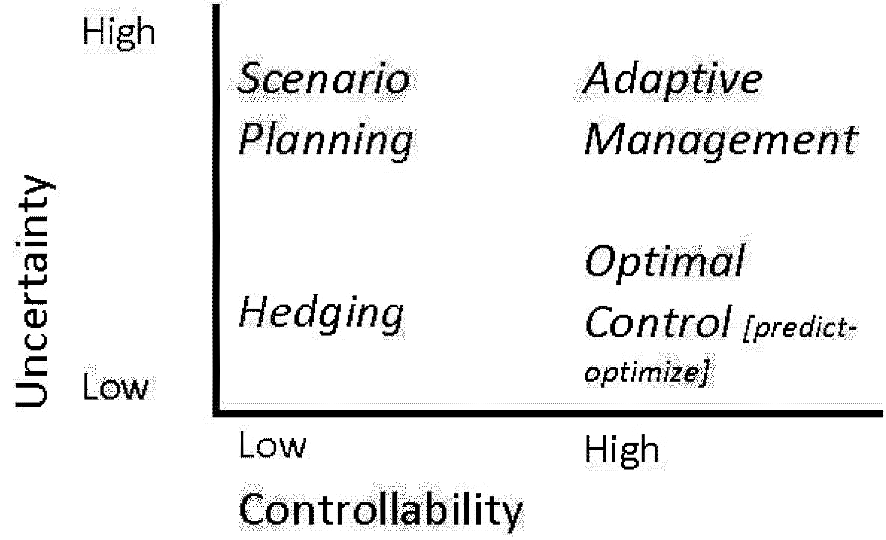
3. Initiating Scenario Planning

In the language of Börjeson et al. [18], the scenario planning approach used in this study is “explorative” and “external”, examining the impacts of external forces on water use and reuse in part of Tucson and Pima County. It is intended to create a number of scenarios that will provide the context for the generation of multiple infrastructure systems optimized using a genetic algorithm. The multiple optimized systems will then be analyzed in an effort to find elements that are sustainable, resilient and robust across all scenarios. The final infrastructure recommendation should minimize the total expected triple-bottom-line cost across all scenarios.
The EFRI-RESIN Scenario Planning process began by identifying participants from local agencies to assist in developing real-world scenarios in conjunction with decision support system modeling. After consulting with utility partners, a list of participants was agreed upon consisting of the University of Arizona research team and City of Tucson and Pima County employees, some of whom had prior experience with Scenario Planning from the process of preparing the Tucson Water Plan: 2000–2050. The Scenario Planning process can be very time and labor intensive. As a result, the research team has established ongoing and alternating meetings between a “small group” of very active participants (comprising University of Arizona researchers, City of Tucson Water Department (Tucson Water), and Pima County Regional Wastewater Reclamation Department (PCRWRD) staff, including project managers, planners, engineers, and hydrologists, and a “large group” of participants who attend only a subset of meetings but provide oversight and ratify (or modify) key decisions made by the small group. The large group meetings include members of the small group and add director and senior level staff from Tucson Water and PCRWRD to assist at critical decision points including ranking the driving forces and identifying the most important uncertainties that influence the scenario matrix design.
The initial question that framed the Scenario Planning process was outlined by the University of Arizona project team as finding the optimal use of integrated water and wastewater in the RESIN planning area, as established in the EFRI-RESIN project goals, using a strategic position that is robust enough to adapt to a credible range of possible uncertain futures. As a result, the optimization is focused on economic and environmental cost-reduction objectives across the entire set of scenarios instead of attempting to identify part of the set of scenarios as “optimal” outcomes.
The geographic definition of the EFRI-RESIN study area is intended to capture possible economies of scale and negotiated to include the land that is most likely to be developed in the future, in consideration of both the physical and institutional environment of Tucson and eastern Pima County (e.g., Tucson Water’s Obligated Service Area for serving new potable water customers and Pima County’s Conservation Lands System aimed at preserving core areas of biological diversity). After framing the focal issue, the small group collectively considered the key factors influencing optimal use of integrated water and wastewater. The exhaustive list of forces (Table 1) included nearly sixty items covering a wide range of factors including: demand based forces (e.g., land-use, per capita residential consumption), supply based forces (e.g., potable water budget), cost based forces (e.g., price per gallon to produce reclaimed water), perception based forces (e.g., publically acceptable water quality), physical-engineering based forces (e.g., the ability to recharge surface/future water supplies), institutional-political based forces (e.g., regional planning uncertainties regarding jurisdiction), as well as the key driving forces in the macro-environment (e.g., external forces that affect rate of economic and population growth). Forces in bold type in Table 1 are those that were short-listed through group process to be included in the ranking of high importance and high uncertainty, as described next.
Table 1. Forces influencing optimal use of integrated water and wastewater in Tucson.
Code Demand-based forces
D1–D2Total water demand—population density & residential demand
D3Future commercial & industrial demand
D4Potential user: Rosemont Mine (proposed copper mine on edge of planning area)
D5Potential user: Tucson Electric Power (water for electricity generation)
D6Outdoor water demand (varies by housing type, swimming pools, vegetation, etc.)
D7Outdoor reclaimed water use
D8Water loss in potable distribution systems (loss and unaccounted water)
D9Water loss in reclaimed distribution system (loss & unaccounted water if dual distribution systems)
CodeSupply-based forces
S1Existing water supplies (legally available groundwater, CAP, effluent/reclaimed water)
S2–S6Potentially available supply—water transfers, importation, desalination, stormwater, Native water leases
S7Wastewater recovery (share of water returned)/ potential effluent supply (reclaimed water budget)
S8Spatial unavailability of “banked water” (Central Arizona Groundwater Replenishment District)
CodeCost-based forces
C1Cost per gallon to acquire and produce potable water
C2Cost per gallon to produce reclaimed water
C3Wastewater collection and treatment
CodePerception-based forces
P1Public opinion acceptability of decentralized wastewater treatment plants and facility siting
P2Publically desired water quality or risk perceptions
P3Public opinion of type of reclaimed water uses with dual distribution system
P4Public adoption of reclaimed water for residential outdoor (dual distribution system)
P5Public acceptance of reclaimed water for fire flow (dual distribution system)
P6Public acceptance/adoption of direct potable reuse (DPR) (single distribution system)
P7Public adoption of indirect potable reuse (IPR) (public acceptance and willingness to pay)
P8Water recovery rate/potential effluent supply (due to household level greywater & rainwater systems)
P9Environmental uses for reclaimed water (in-stream flows)
P10Outdoor greywater use and length (period) of adoption
P11Outdoor rainwater catchment/adoption
P12Willingness to pay to treat to high quality potable water
P13Willingness to pay for new potable water supplies
P14Willingness to pay for reclaimed water (e.g., reclaimed water by end-use water quality/class of effluent)
Code(Physical)-engineering based forces
E1Ability to recharge reclaimed water supplies (e.g., physical location of recharge facilities)
E2Ability to recharge surface/future water supplies (e.g., depth to bedrock)
E3Ability to recharge stormwater
E4Ability to desalinate
CodeInstitutional-political based forces
I1Planning and implementation uncertainties (City/County rights, jurisdictional issues & coordination)
I2Water providers
I3Potable water rates
I4Sewer rates (wastewater)
I5Reclaimed water rates
I6Conservation rules, ordinances, regulation, incentives for water (rainwater, greywater, stormwater)
I7Costs/rate subsidy for low-income residents
I8Utility level drought plans
I9Transfer of development rights across jurisdictions
I10Federal, state or local rules, ordinances, regulation, incentives for land (land use, zoning, planning)
I11State Lands release (sale for revenue), planning, and disposition (timing of release, which parcels)
CodeMacro forces in the larger environment
M1Population timing variability (rate of economic and population growth, vacancies)
M2Long-term population (when might it stabilize, and at what level?)
M3Supply uncertainty due to local drought
M4–M5Supply uncertainty—regional drought, Colorado River water sharing, climate change
M6Bond ratings of City or Tucson and Pima County
M7Infrastructure cost (finance, discount rate for timing of construction)
M8Federal institutional and legislative changes
M9State institutional and legislative changes
M10Existing water rights changes (surface, groundwater, reclaimed water rights)

4. Ranking Driving Forces

The next step of the Scenario Planning process involved ranking the driving forces noted above in terms of their importance and uncertainty. Both the large and small groups participated in collectively plotting the relevant forces on axes of uncertainty and importance, as seen in Figure 3, which conveys the evolution of the priority-setting process. The ranking process was subjective and consensus based, with forces being ranked relative to one another rather than according to any absolute scale. The most uncertain and most important forces included: (a) demand based forces of population density and per capita residential demand (D1, D2); (b) supply based forces including all potentially available future water supplies (S1, S2, S4, S5, S8); (c) macro based forces including the regional supply uncertainty (both in terms of quantity and quality) due to extended droughts, Colorado River shortage sharing agreements, and the potential effects of climate change (M4, M7); (d) perception based forces of public adoption of indirect potable reuse of effluent (including willingness to pay) (P7); and (e) the institutionally based force of State Land release into the market, in terms of both location and timing (I11).
Figure 3. (a) Initial plot of key forces according to importance and uncertainty. Only those forces considered to have particularly high importance and uncertainty were plotted; (b)Interim plot of forces reflecting merged forces and reconsidered uncertainties and importance; (c) Final plot of forces showing further merging and elimination of less critical forces.
Water 04 00848 g003
The most important step in the Scenario Planning process was to identify, among the critically ranked factors, the two or three with the highest impact and uncertainty for integrated water and wastewater planning in the study area. After multiple meetings and rounds of debate, consensus was achieved on the following three most important and uncertain scenario drivers and their “endmembers” (i.e., extreme maximum and minimum probable values): (a) water and reuse demand ranging from high to low population within the study area at high and low per capita demand; (b) available renewable water supply ranging from existing supply to a reduced supply; and (c) public perception of water reuse ranging from acceptance of indirect potable reuse (IPR) to no acceptance of IPR. These endmembers form the bounds of a wide range of probable futures, and ideally are chosen so as to be feasible but unlikely extremes. Solutions that are successful in all extreme, endmember futures should also be successful in the range of futures that are less extreme.
In order to achieve consensus on just three drivers, these drivers were formed by merging multiple factors and attempting to find the single variable that is common to all merged factors. As an example, factors M4 and M5 (together comprising supply uncertainty due to regional drought, Colorado River shortage sharing and climate change) were merged with factors S1–S6 (existing supply and potentially available supply affected by local context) to create the Supply driver, on the grounds that for infrastructure purposes in an outlying portion of an existing service area, the total volume of supply is more crucial than the various factors that determine that volume. This demonstrates a key benefit of the Scenario Planning process: that it helps participants to reduce highly complex problems into their most critical and relevant components. For a different process, such as one to plan treatment strategies for the entire water utility, the source of water would perhaps be at least as critical as the volume, but in this case water enters the study area treated to potable standards regardless of source. Changes in the sources used for Tucson’s water supply could impact the cost of water, potentially resulting in higher pricing and lower demand, but that potential future is absorbed into the demand driver and need not be considered as part of the supply driver. These three drivers combine to form eight unique scenarios, or endmember futures, as follows, and as shown in Figure 4.
Figure 4. Scenario matrix.
Water 04 00848 g004

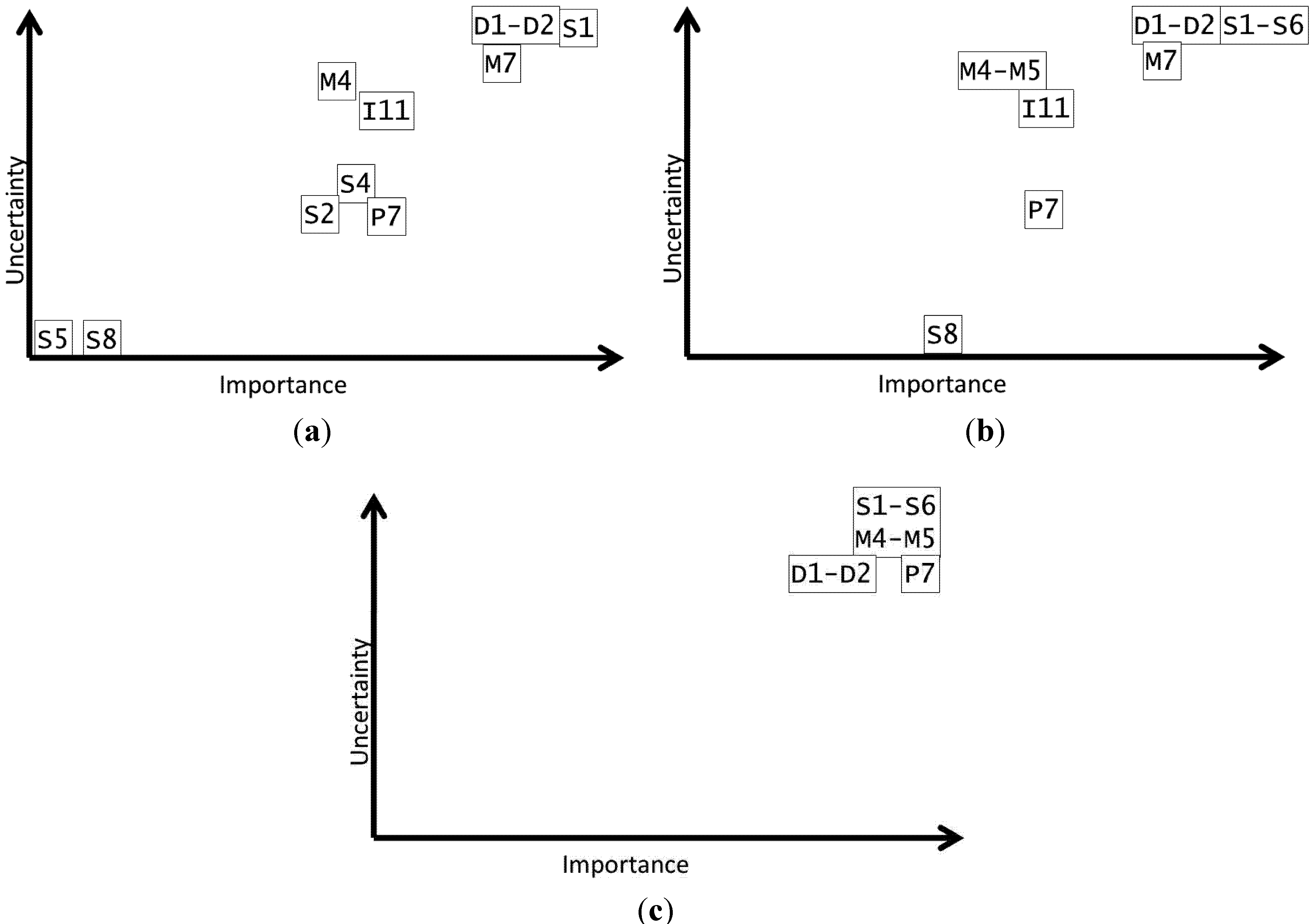
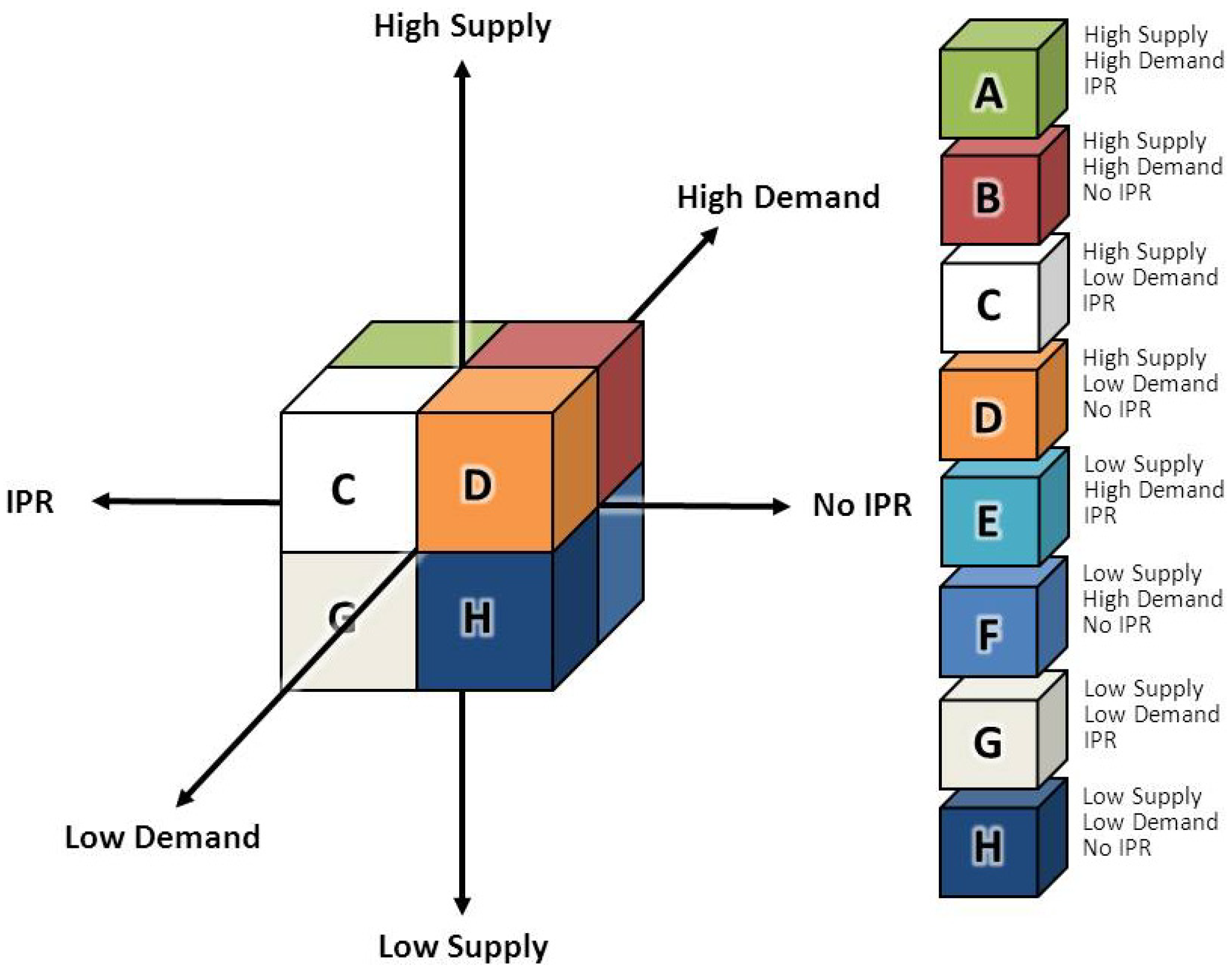
5. Scenarios and Driving Forces

High Supply, High Demand, IPR
High Supply, High Demand, No IPR
High Supply, Low Demand, IPR
High Supply, Low Demand, No IPR
Low Supply, High Demand, IPR
Low Supply, High Demand, No IPR
Low Supply, Low Demand, IPR
Low Supply, Low Demand, No IPR

5.1. Supply Based Drivers

The supply-based driver is the most complex force with the widest geographical influences and greatest inter-regional effects. This is largely true of other regions. As a result, it forms the principal focus of this paper and may need some additional explanation. The selected endmembers were the continuation of the existing renewable supply or a reduction from the existing supply. The existing renewable supply is essentially made up only of Colorado River water delivered via CAP. As described in Section “1.1. Context” above, Colorado River supplies are likely to become increasingly vulnerable to the effects of climate change. Estimates of flow range from 9% to 30% reductions by mid-century, averaging around 15% [19]. Given that the most recent shortage sharing agreement in 2007 affects purchasers of “excess” water, recharge and agricultural uses before tribal or municipal uses, the Arizona Department of Water Resources considers a 10% reduction in CAP supply to Tucson Water to be a reasonable maximum reduction before 2050 [20], and this has been adopted by the Scenario Planning team.
In scenarios where the 10% reduction in supply occurs, additional water supplies could be used to make up a shortfall, such as large-scale local aquifer/groundwater mining being resumed or increasing reliance on additional water supplies imported from outside the local region, which could include desalinized seawater or brackish groundwater, groundwater mined from outlying basins, or Colorado River water currently being used by agricultural right-holders along the Colorado River. The latter two are currently being considered under the Central Arizona Project’s Acquisition, Development and Delivery (ADD Water) Program [21], which is under development. Importantly, the future availability of many of these potential supply options for the City of Tucson, Pima County, or other local water users are uncertain since they require agreement on the part of other parties. The generic relevance of the approach described in this paper is the stakeholder-based process, supported by advanced modeling, to address sustainable future availability. As shown in the Tucson case, continued reliance on local groundwater mining (i.e., overdraft) to support future municipal growth is currently constrained by the State’s Assured Water Supply rules as outlined in Arizona’s Groundwater Management Act [22]. In essence, the stakeholders and the Scenario Planning team assume additional water supplies will become available—even if there is currently “insufficient” supply—but importantly for the purposes of optimization it will come at a higher price, the determination of which has not yet been decided and will be covered in future work on the optimization process The optimization will also examine other mechanisms to achieve sustainability, such as demand reduction in the form of voluntary or mandatory restrictions on water use (lawn buyback, prohibition of pools at single-family homes, etc.).The endmembers were agreed upon as continuation of the current 177.8 MCM (144,000 acre-feet) per annum supply to Tucson Water’s entire service area, or a ten percent reduction in supply, resulting in 166.0 MCM (130,000 acre-feet) per annum.

5.2. Perception Based Drivers

The crucial perception-based uncertainty identified is whether the public will accept reclaimed water as part of their drinking water supplies through indirect potable reuse (IPR). This challenge exists, and will increase, worldwide [23]. Tucson Water has long valued the potential of reclaimed resources and most heavy irrigators (golf courses, public parks, and schools) are already connected to the reclaimed water system with highly visible public signage where it is being used [24]. Although reclaimed water use in the Tucson area is currently largely limited to outdoor irrigation, a number of additional reclaimed water applications are possible in the future, including IPR.
A number of IPR projects are in practice or are being considered in high-growth urban areas throughout the southwestern USA [25], but an alternative of expanding the reclaimed water system to the household level to serve more non-potable uses (e.g., for residential outdoor uses or toilet flushing) is an option with high levels of public acceptance [26]. However, this option would require a dual pipe system to keep reclaimed supply separate from potable supply and so is likely to incur higher costs [26], which may or may not be acceptable to customers. Out of the range of possible effluent reuse futures outlined in Tucson Water’s 2004 Scenario Planning process (an entirely separate process to the one described here), IPR was considered to offer maximum water use efficiency [26]. While generally the preferred option for the stakeholders, future implementation of IPR will be heavily dependent upon public perception; as a result, alternatives to IPR such as continuing to release reclaimed water in otherwise-dry stream corridors, are given equal weight within the RESIN Scenario Planning process. When planning IPR projects, public perception is considered the greatest obstacle to successful implementation [27]. Research by Macpherson, Snyder and others for the WateReuse Research Foundation [27] suggests that exposing consumers to the existing de facto indirect potable reuse situation in the vast majority of water supplies can powerfully alter perceptions of planned potable reuse, with consumers viewing planned potable reuse as actually being safer than the status quo.
Given that population growth will increase demand for water, attitudes toward regional growth and development are crucial to understanding opinions about risks and reclaimed water [28]. In addition to political resistance to urban sprawl, Tucson is also recognized for its rancorous water politics [29]. For example, in 2007 a citizen-led ballot initiative, entitled Tucson Water Users Bill of Rights, sought to ban any possibility of potable water reuse and limit future water connections. Although the 2007 ban failed, the threat of citizen intervention is considered a likely possibility where IPR is concerned; this is an important process that readers of Water, who may be disinterested in the specific details of the Tucson case, should consider.
IPR, dual distribution or significant reductions in consumption all come with potential concerns or inconveniences for the customer. While Tucson Water prefers IPR as a future strategy, it is uncertain whether consumers will eventually come to accept IPR in the Tucson area, and a key use of the generated scenarios will be to test proposed distribution networks by considering how robust the planned infrastructure would be to changes in consumers’ perceptions about the acceptability of IPR.

5.3. Demand Based Drivers

The generic infrastructure problem addressed in this paper is how to meet uncertain future demand for water. Urban planning at the city and county level currently directs much of the growth in the Tucson region toward the southeast, where the land is relatively flat and owned in the most part by the Arizona State Land Trust. This corresponds to the EFRI-RESIN study area (refer to boundary in Figure 5a–d, below). Local government master plans such as the Houghton Area Master Plan [30], covering the northeastern portion of the study area, have been designed to create higher densities of development than have previously been developed in the area.
Figure 5. (a) Legend for projected population densities in the EFRI-RESIN study area; (b) Projected 2050 population densities using the Status Quo model; (c) Projected 2050 population densities using the Habitat Protection model; (d) Projected 2050 population densities using the Infrastructure Efficient model.
Water 04 00848 g005
If continually supported and enforced, Pima County’s Conservation Lands System Regional Plan Policy [31] has the potential to form a clearly defined edge to future development within the study area, but not to the patchwork of development or densities that may result within the area to be developed. The southeastern portion of the study area is defined as “Biological Core”, requiring that a 4:1 conservation land set-aside ratio be integrated into rezonings and comprehensive plan amendments. In addition, a combination of riparian corridors protected by the Conservation Lands System and floodways defined by the Lee Moore Wash Basin Management Study [32] creates multiple corridors of open space running through the southwestern portion of the study area. All this adds significantly to uncertainties. The joint City of Tucson and Pima County study entitled Location of Growth, Urban Form and Cost of Infrastructure [33] analyzed the effect of the Conservation Land System and potential high-density development on predicted build-out densities across the Tucson metropolitan area, expected in the coming 50 years or longer.
For the EFRI-RESIN study, the white paper’s patterns and densities of development were analyzed again at a coarser scale to ease future computer modeling of infrastructure and to incorporate the Lee Moore Wash Basin Management Study. A Microsoft Excel and ESRI ArcGIS model was run with various input populations to provide the Scenario Planning small group with a selection of potential endmembers ranging from 85,000 to 740,000 inhabitants in the study area, based upon projections for the year 2050 from multiple City, County and joint studies. Figure 5 shows the current population distribution and three possible 2050 distribution types modeled for this paper using a population of 460,000. The small group indicated a preference to use only the Infrastructure Efficient model (Figure 5d), stating that the newest developments in the study area already demonstrate higher densities than are present in the Habitat Protection and Status Quo models. The small and large groups agreed that 2050 populations of 460,000 and 740,000 should form the population endmembers, as both figures came from sources created jointly and frequently referenced by City and County departments. The use of previously existing and widely accepted sources should bolster the legitimacy of the scenarios when they are revealed to a wider audience. Like numerous cities in developed and developing countries alike, Tucson has experienced very rapid growth but was also hit very hard by the economic recession and real-estate slowdown in the late 2000s, so growth rates may be subject to the extreme volatility suggested by the broadly divergent endmembers.
The Scenario Planning team uses a genetic algorithm for infrastructure considering all eight scenarios, based upon a square grid modeled on Tucson’s existing street layout. All links of the grid represent possible potable or reclaimed water transmission pipes. Each intersection (node) on the grid represents a demand point for water, with demand determined by the MS Excel/ESRI ArcGIS model described above. Using a genetic algorithm, the model selects pipe diameters and pump parameters (design head and flow). The genetic algorithm can also select amongst multiple possible locations for decentralized wastewater reclamation. Costs for the pipe are based on a function that is nonlinear with respect to diameter and the depth of excavation and linear with respect to length, given in Clark et al. [34]. Pipes 12 in. and lower in diameter are modeled as PVC; those of larger diameters, as ductile iron. Costs for pumps are modeled as a nonlinear function of design pressure and flow. Additionally, life-cycle costs of pipes, pumps and decentralized treatment facilities, including environmental offset costs, are estimated. While system design considerations such as these occur after Scenario Planning, and as such are not reported on in detail here, they are a direct result of the process and are considered to provide robust planning results under conditions of uncertainty. This optimization process, which will generate eight solutions based upon the eight scenarios, will be discussed in detail in a future paper. The final stages of the process will be to find common elements amongst all of these solutions, narrow the solution space for elements that are not identical between scenarios, and solve for an overall solution that minimizes expected cost over the eight scenarios. Thus, the network model is used to analyze the eight scenarios identified and prioritized through the stakeholder process described above.

6. Discussion

In applying Scenario Planning to water and wastewater system optimization in the Tucson and Pima County study area, it became necessary to make several assumptions in order to fix “non-critical” but clearly important uncertainties, notably D3 (industrial and commercial demand), I2 (water providers) and M1 (population timing variability). Scenario Planning was a tool developed for strategic challenges to aid decision-making in broad, complex contexts. Optimization of pipe sizes, on the other hand, requires absolute rather than relative information, which potentially overspecifies the scenarios. An example of complex challenges that Scenario Planning is suited to address is provided by population growth rates. The EFRI-RESIN team used a starting population for the study area provided by the 2010 U.S. Census (just over 50,000), and populations for the year 2050 defined by the Demand endmembers of 460,000 and 740,000. The project team intended to find optimal system definitions at multiple stages within the 40-year period to determine the timing of proposed construction, and so population had to be interpolated somehow. The choice of a population growth model was far from trivial, and it could be argued that the difference between a boom-and-bust cycle of growth and steady growth is every bit as critical an uncertainty as the final population figures. Challenges in applying Scenario Planning to this type of problem were expected.
The Scenario Planning process has provided an opportunity for staff from two organizations that are often out of step, with divergent mandates and institutional cultures, to work jointly in a facilitated process. Fundamental differences of opinion have occurred, but in the effort to make progress towards a common objective, accommodation and compromise were found relatively easily. The building of mutual understanding is a core aim of Scenario Planning, whether within a single organization or in a multi-stakeholder process. Particularly valuable is the way in which the use of endmembers allows the expectations of all stakeholders to be bracketed without agreement over specific figures. Stakeholders thereby maintain their voice throughout the process without being forced into painful compromises.
Scenario Planning has also served to clearly identify which uncertainties critically apply at which scale of planning. Previous Scenario Planning efforts by Tucson Water identified public tolerance of high dissolved solids (the “salty taste of water”) as a critical uncertainty in choosing how to manage Tucson’s CAP allocation. At the more local scale, however, Tucson Water’s treatment process for CAP water was not considered a critical uncertainty, and other forces took precedence. The focus upon only critical uncertainties required by Scenario Planning significantly aided the team in making long-range plans in what would otherwise represent a confusingly broad array of factors. The way in which uncertainties have tended to become increasingly generalized, such as the merging of factors M4 and M5 (macro-scale climatic change) with factors S1–S6 (local supply uncertainties including paper water transfers), during the determination of drivers and endmembers has also been extremely valuable in reducing the difficulty of planning around “unknown unknowns”. It becomes apparent that in many ways it matters little what causes a critical factor to change if the system is designed to be resilient and robust enough to handle the change.
The evolving, iterative process of Scenario Planning described in this paper reflects the importance of new information, both on changing current conditions but also on enhanced understanding of future trends. As a result, the process must be seen as continuous, entailing reconsideration—even redefinition—of uncertainties. And following the typology of planning models presented in Figure 1, some planning forces may themselves be subject to management if not outright “control.” In this sense, Scenario Planning is a robust tool to accommodate broad regional and global forces such as climate change or urban development. By contrast, adaptive management may seek to alter the degree and intensity of more localized driving forces, such as water use from a particular source, by limiting their impacts on planning and development.

7. Conclusions

Planning for the future requires flexibility to adapt to changing future conditions. Even local initiatives with relatively good access to information and future projections—such as the Tucson and Pima County, Arizona case presented here—are confronted with major uncertainties. When considered in a broader global context, uncertainties can lead to poor outcomes from investments of financial, human, and natural resources by public and private and decision-makers. In this case, Scenario Planning has provided a robust tool to consider multiple potential outcomes over the long term. This paper has demonstrated that rigorously ranking planning forces by the level of uncertainty and degree of importance can clarify discussion and build consensus among decision-makers on ways forward, particularly where a wide divergence of opinions is present and the number of factors under consideration is large.
The collaboration of researchers and planners described in this paper, which is a particular instance of science-policy dialogue to address global change in the broadest sense, has led to some notable innovations. Chief among these is the enhanced identification of drivers and uncertainties and the integration of qualitative, participatory processes with quantitative modeling, leading to the improved uptake of information in scientific/engineering and planning models and improvement to the relevance of these models to real-world conditions and to political and institutional contexts in which decision-making occurs. Finally, the inclusion of policy questions and challenges in research at the fundamental level of framing questions and not simply in the more conventional mode of science providing answers without regard to stakeholders’ needs and priorities is leading toward valuable results not only for the research team but for the stakeholders involved.
The approach described in this paper has addressed numerous uncertainties that confront water, reuse, and urban growth planning in the context of water scarcity, climate variability, uncertain development processes, and evolving public perception. The implications of the specific Arizona case assessed here have broader generic relevance. First, the sustainable development objectives of urban growth conforming to natural resource constraints can be pursued through Scenario Planning aided by modeling. Second, a more open and iterative science-policy process greatly enhances the interface between the scenario modeling and policy-making and can improve working relationships not only between academia and government but also between government entities. Finally, emerging approaches to decision making must account for uncertainties not only through attempts to reduce uncertainty (though modeling may enhance this ability) but also, as demonstrated here, by identifying and focusing upon critical uncertainties and considering their impacts in complex biophysical, social, and political-institutional contexts.

Acknowledgments

The authors would like to acknowledge the following sources of support: the U.S. National Science Foundation (NSF) under Grant No. EFRI-0835930, the Inter-American Institute for Global Change Research project SGP-CRA #005 (which is supported by NSF Grant No. GEO-1138881), the National Oceanic and Atmospheric Administration’s Climate-Society Interactions Program, and STAR Fellowship Assistance Agreement #FP91735701-0 awarded by the U.S. Environmental Protection Agency. Any opinions, findings, and conclusions or recommendations expressed in this material are those of the authors and do not necessarily reflect the views of the supporters of the research. The authors especially wish to express their appreciation and thanks to members of the Scenario Planning process described in this paper.

References and Notes

  1. UN-Water. In Global Analysis and Assessment of Sanitation and Drinking-Water (GLAAS); World Health Organization: Geneva, Switzerland, 2010.
  2. Milly, P.C.D.; Betancourt, J.; Falkenmark, M.; Hirsch, R.M.; Kundzewicz, Z.W.; Lettenmaier, D.P.; Stouffer, R.J. Stationarity is dead: Whither water management? Science 2008, 319, 573–574. [Google Scholar]
  3. Browning-Aiken, A.; Ormerod, K.J.; Scott, C.A. Testing the climate for non-potable water reuse: Opportunities and challenges in water-scarce urban growth corridors. J. Environ. Policy Plan. 2011, 13, 253–275. [Google Scholar] [CrossRef]
  4. Schwartz, P. The Art of the Long View: Planning for the Future in an Uncertain World; Doubleday: New York, NY, USA, 1996. [Google Scholar]
  5. Garfin, G.; Varady, R.G.; Romero-Lankao, P. Rethinking integrated assessments and management projects in the Americas. Environ. Sci. Policy. 2012. Available online: http://www.sciencedirect.com/science/article/pii/S1462901111002000 (accessed on 1 November 2012). [CrossRef]
  6. Peterson, G.D.; Cumming, G.S.; Carpenter, S.R. Scenario Planning: A tool for conservation in an uncertain world. Conserv. Biol. 2003, 17, 358–366. [Google Scholar] [CrossRef]
  7. Van der Heijden, K. Scenarios: The Art of Strategic Conversation; Wiley: Chichester, UK, 1996. [Google Scholar]
  8. Kok, K.; van Vliet, M.; Bärlund, I.; Dubel, A.; Sendzimir, J. Combining participative backcasting and exploratory scenario development: Experiences from the SCENES project. Technol. Forecast. Soc. Chang. 2011, 78, 835–851. [Google Scholar] [CrossRef]
  9. Gleeson, T.; Alley, W.M.; Allen, D.M.; Sophocleous, M.A.; Zhou, Y.; Taniguchi, M.; VanderSteen, J. Towards sustainable groundwater use: Setting long-term goals, backcasting, and managing adaptively. Ground Water 2012, 50, 19–26. [Google Scholar] [CrossRef]
  10. Pahl-Wostl, C.; Sendzimir, J.; Jeffrey, P.; Aerts, J.; Berkamp, G.; Cross, K. Managing change toward adaptive water management through social learning. Ecol. Soc. 2007, 12, 30:1–30:18. [Google Scholar]
  11. Sellers, J. Information needs for water resources decision-making. Nat. Resour. Forum 1993, 17, 228–234. [Google Scholar] [CrossRef]
  12. Marra, R.; Thomure, T. Scenario Planning: Making strategic decisions in uncertain times. Southwest Hydrol. 2009, 3, 22–23, 32. [Google Scholar]
  13. Lansey, K. Sustainable, Robust, Resilient Water Distribution Systems. In Proceedings of the 14th Water Distribution Systems Analysis Symposium, Adelaide, Australia, 24-27 September 2012.
  14. Population Growth by Decade. Pima Association of Governments: Tucson, AZ, USA. Available online: https://www.pagnet.org/RegionalData/Demographics/PopulationGrowthbyDecade/tabid/123/Default.aspx (accessed on 27 August 2012).
  15. The acre-foot (equivalent to 1233.48 cubic meters) is the standard measure of water volume used in the Western U.S. In order for this paper to be useful for international and U.S. readers we report volumes in both million cubic meters and acre-feet.
  16. Coles, A.R.; Scott, C.A. Vulnerability and adaptation to climate change and variability in semi-arid rural southeastern Arizona, USA. Nat. Resour. Forum 2009, 33, 297–309. [Google Scholar] [CrossRef]
  17. Ormerod, K.J.; Scott, C.A. Drinking wastewater: Public trust in potable reuse. Sci. Technol. Hum. Values. 2012. Available online: http://sth.sagepub.com/content/early/2012/04/23/0162243912444736.abstract (accessed on 29 June 2012). [CrossRef]
  18. Goeminne, G.; Mutombo, E. The Field of Scenarios: Fuzziness as a Chance for Building Appealing Future Visions; Working paper for the CONSENTSUS project; Centrum voor Duurzame Ontwikkeling, Universiteit Gent: Brussels, Belgium; Centre d'études du développement durable, Université Libre de Bruxelles: Brussels, Belgium, 2007. Available online: http://www.belspo.be/belspo/ssd/science/Reports/A3_Goeminne_Mutombo_The%20field%20of%20scenarios_WP2_CDO_ULB.pdf (accessed on 27 August 2012).
  19. Gammage, G.; Stigler, M.; Clark-Johnson, S.; Daugherty, D.; Hart, W. Watering the Sun Corridor: Managing Choices in Arizona’s Megapolitan Area; Morrison Institute for Public Policy: Phoenix, AZ, USA, 2011. [Google Scholar]
  20. Lead Hydrologist. Personal communication, Tucson Water: Tucson, AZ, USA, 2012.
  21. ADD Water is an ongoing stakeholder process aimed at identifying new water supplies for water users within the Central Arizona Water Conservation District’s (CAWCD) three-county service area as well as for outlying areas. The CAWCD operates and manages the CAP and also provides groundwater replenishment services under the Central Arizona Groundwater Replenishment District. For further details, see Homepage http://www.projectaddwater.com.
  22. Colby, B.G.; Jacobs, K.L. Arizona Water Policy: Management Innovations in an Urbanizing, Arid Region; RFF Press: Washington, DC, USA, 2007. [Google Scholar]
  23. Po, M.; Kaercher, J.D.; Nancarrow, B.E. Literature Review of Factors Influencing Public Perceptions of Water Reuse; Commonwealth Scientific & Industrial Research Organisation (CSIRO) Report 54; CSIRO Land and Water: Black Mountain, Australia, 2003. [Google Scholar]
  24. Scott, C.A.; Browning-Aiken, A.; Ormerod, K.J.; Varady, R.G.; Mogollon, C.D.; Tessmer, C. Guidance on Links between Water Reclamation and Reuse and Regional Growth; WateReuse Research Foundation Report 06-016-1; WateReuse Research Foundation: Arlington, VA, USA, 2011. [Google Scholar]
  25. Campbell, A.; Scott, C.A. Water reuse: Policy implications of a decade of residential reclaimed water use in Tucson, Arizona. Water Int. 2011, 36, 908–923. [Google Scholar] [CrossRef]
  26. Water Plan: 2000–2050. City of Tucson Water Department’s Planning and Engineering Division: Tucson, AZ, USA, 2004. Available online: http://cms3.tucsonaz.gov/water/waterplan (accessed on 19 June 2012).
  27. Macpherson, L.; Snyder, S. Water Reuse Public Acceptance: Context Matters (webinar). In WateReuse Research Foundation Webcast Series; WateReuse: Alexandria, VA, USA, 2012; Webcast recorded on14 June 2012. [Google Scholar]
  28. Asano, T. Urban water recycling. Water Sci. Technol. 2005, 51, 83–89. [Google Scholar]
  29. Logan, M. Fighting Sprawl and City Hall: Resistance to Urban Growth in the Southwest; University of Arizona Press: Tucson, AZ, USA, 1995. [Google Scholar]
  30. City of Tucson, Department of Urban Planning and Design. Houghton Area Master Plan. 2005. Available online: http://www.tucsonaz.gov/planning/plans/all/hamp.pdf (accessed 20 June 2012).
  31. Pima County Development Services. Conservation Lands System Regional Plan Policy. 2005. Available online: http://www.pimaxpress.com/Documents/Planning/ComprehensivePlan/PDF/CLS/CLS_Adopted_Policy.pdf (accessed 20 June 2012).
  32. Stantec Consulting Inc. Lee Moore Wash Basin Management Study: Summary Report; Stantec Consulting Inc.: Tucson, Arizona, U.S.A, 2009. Available online: http://rfcd.pima.gov/largefiles/reports/leemoore/leemoore_final_summary_report_0916_2009.pdf (accessed 20 June 2012).
  33. Location of Growth, Urban Form, and Cost of Infrastructure: A White Paper Supporting Phase 2 of the Water and Wastewater Infrastructure, Supply and Planning Study. 2005. Available online: http://www.tucsonpimawaterstudy.com/Reports/Phase2/White_paper_6.14.09.pdf (accessed 19 June 2012).
  34. Clark, R.M.; Sivaganesan, M.; Selvakumar, A.; and Sethi, V. Cost models for water supply distribution systems. J. Water Resour. Plan. Manag. 2002, 128, 312–321. [Google Scholar] [CrossRef]

