Designing Sustainable Urban Social Housing in the United Arab Emirates †

Architectural Engineering Department, College of Engineering, UAE University, Al Ain, P.O. Box 15551, UAE
†
This paper is an extended version of a paper titled “Thinking Beyond Zero-Energy Buildings: Investigating Sustainability Aspects of Two Residential Urban Forms in UAE” presented in the 5th International Conference on Zero Energy Mass Customized Housing-ZEMCH 2016, 20–23 December 2016, Kuala Lumpur, Malaysia.
Sustainability 2017, 9(8), 1413; https://doi.org/10.3390/su9081413
Submission received: 30 June 2017
/
Revised: 4 August 2017
/
Accepted: 4 August 2017
/
Published: 10 August 2017
(This article belongs to the Special Issue Climate Change Mitigation and Adaptation - ZEMCH 2016)
Abstract
:The United Arab Emirates is experiencing a challenging turn towards sustainable social housing. Conventional neighborhood planning and design principles are being replaced by those leading to more sustainable urban forms. To trace this challenging move, the research has investigated the degree of consideration of sustainable urban design principles in two social housing neighborhoods in Al Ain City in Abu Dhabi Emirate, UAE. The first represents a conventional urban form based on the neighborhood theory; the other represents the new sustainable design. The ultimate aim is to define the obstacles hindering the full achievement of a sustainable urban form in this housing type. To undertake research investigations, a matrix of the design principles of sustainable urban forms has been initiated in order to facilitate the assessment of the urban forms of the two selected urban communities. Some qualitatively measurable design elements have been defined for each of these principles. The results of the analysis of the shift from ‘conventional’ to ‘sustainable’ case studies have revealed some aspects that would prevent the attainment of fully sustainable urban forms in newly designed social housing neighborhoods. Finally, the research concludes by recommending some fundamental actions to help meet these challenges in future design.
1. Introduction
Sustainable urban form is generally defined as attaining sustainable urbanism through configuring its shape, function, and adaptability to change over time [1,2]. Handy and Niemeier [3] claim that sustainable urban form is relevant to residents’ behavior within the built environment, thus stimulating residents to be more vigorous and to positively utilize urban spaces. Neuman [4] argues that sustainable urban form manifests both the process and the product that emerges from it. The formation of sustainable urban form integrates various sustainability features of cities in living, consuming, and producing. Accordingly, comprehending the influences of a specific urban form on environmental and social issues necessitates understanding the interrelated, inclusive, and adaptive processes producing such an urban form.
Additionally, one cannot define a single urban form as sustainable. Rather, there are various urban forms that suit a specific context—depending chiefly on the socioeconomic and environmental context of an area and its associated development objectives and plans. In general terms, an urban form can be called sustainable when it is responsive to the carrying capacity of the natural and the built environment, can provide a friendly living setting, and contributes to social justice [5].
Allen [6] outlines four dimensions that shape the sustainable urban form. First is the environmental dimension, which relates to the influence of urban production and consumption on the integrity and vigor of the urban area and its carrying capacity. Second is the social dimension, which entails the equity, inclusiveness, and adequacy of urban development, as this would endorse social justice that supports the livelihoods of residents in local communities. Third is the economic dimension, which entails the ability to exploit both local and regional resources for the welfare of the whole community. Fourth is the political dimension, which deals with the quality of urban governance in controlling the decision-making processes of different actors among the three former dimensions.
Social or public housing in the United Arab Emirates (UAE) has been developing since the establishment of the UAE in 1971. It started with the aim of providing public houses for nomadic and urban Emirati citizens. Currently, the main federal agency for the provision of social housing in the UAE is the Ministry of Public Works and Housing, established in 1972, and the Sheikh Zayed Housing Program, established in 1999 [7]. More recently, each Emirate has established its own local social housing agency to respond to its citizens’ increasing demand for housing. These local social housing agencies include: Mohamed Bin Rashid Housing Establishment in Dubai, established in 2007; Sheikh Saud Housing Program in Ras Al Khaimah, established in 2008; the Housing Department in Sharjah, established in 2010; and Abu Dhabi Housing Authority, established in 2012 [8]. Since their establishment, both federal and local housing agencies have embarked on developing heavily subsidized social housing programs with a concentration on building social housing neighborhoods, following in their planning the principles of the conventional, functional, and self-contained Clarence Perry neighborhood design model. The areas of the housing plots in these neighborhoods have been generous, while the housing models were identical single-family houses that contained between three and five bedrooms on one or two floors.
In the last few years, the UAE has witnessed growing interest in sustainable development as the country has adopted a political agenda calling for achieving sustainability in all its development plans, including social housing. In accordance with that trend, the UAE has launched ambitious sustainable urban initiatives, such as ESTIDAMA (the Abu Dhabi Emirate’s officially adopted version of the LEED (Leadership in Energy and Environmental Design), the internationally-recognized green building certification system developed by the U.S. Green Building Council (USGBC) and Masdar City, the first zero carbon emissions city in the world, to widen the application of sustainability in the building and urban housing sectors. In appreciation of this role, the UAE has been selected as the host country for the International Renewable Energy Agency (IRENA) headquarters [9].
This governmental policy of adopting a sustainable future agenda is reflected currently in social housing neighborhood design. Some limited pioneering projects have emerged lately in which conventional neighborhood planning and design principles are being replaced by what are perceived to be more sustainable ones.
2. Research Problem, Method, and Limitations
This research is concerned with investigating the ‘level of consideration’ of sustainable urban form design principles in the UAE’s new social housing neighborhoods, which have been designated as ‘sustainable’ in comparison with conventional neighborhood designs. Al Ain City in Abu Dhabi Emirate has been selected as a locus for this investigation because it has been officially proclaimed as a model for green/sustainable cities in the UAE. To explore the research problem, a conceptual design matrix for the principles of sustainable urban form and their detailed ‘design elements’ was initiated through reviewing the relevant literature, as shown below, in order to facilitate the assessment of the produced urban forms of the two selected social housing communities in Al Ain: Al Salamat and Shaubat Al Wuttah, representing the past conventional and the present sustainability-orientated designs, respectively. Design principles of sustainable urban form and their relevant design elements have been defined in this conceptual design matrix.
In order to reach a satisfactorily qualitative assessment of these designs in the two case studies, two steps were conducted. First is qualitatively and individually assessing each of the defined design elements (as summarized in Table 1). Second is using the results of the assessments of each set of design elements as an indicator of the overall design principle associated with this set of design elements.
A simplified qualitative assessment scale was used in this assessment process, indicating five ‘levels of consideration’ for each of the design elements and, thus, their associated principles in the case study’s urban form design, namely, ‘fully considered’, ‘significantly considered’, ‘averagely considered’, ‘marginally considered’, and ‘not considered’. This assessment, of course, depends on the subjective interpretation of the analysis by the researcher and thus might not be fully accurate and might even be debatable, but the nature of the available data would make this qualitative assessment method the most appropriate. This limitation would mean that this research is actually measuring ‘tendency’ towards sustainable urban form in neighborhood design rather than accurately measuring each design element in detail, as this obviously would require further prolonged research, which is not the aim of this research. The investigation tools utilized in this qualitative assessment were CAD drawings, Google Earth maps, photographs, field observations during site visits, and informal interviews with Al Ain Municipality officials.
Comparing the assessment results of the new, sustainable neighborhood with those of the conventional one has helped with defining the changes and persistent challenges experienced in the design of the urban form of new neighborhoods. Ultimately, a proposed conceptual futuristic design scenario for achieving a more sustainable urban form of social housing in the UAE has been recommended through the interpretation of the outcomes of the research investigations. Figure 1 summarizes the research method, its utilized tools, and its intended outcomes.
3. A Conceptual Design Matrix for Sustainable Urban Form
To initiate a sustainable urban form matrix of principles and their relevant design elements, the research has consulted a wide variety of references about sustainable urbanism [5,6,7,10,11,12,13,14,15], New Urbanism [16], Smart Growth [17], Traditional Neighborhood Design (TND) [18], Transit-oriented Development (TOD) [19], Sustainable Neighborhood Planning [20], and Livable Communities [21]. With the acknowledged difficulty of developing a comprehensive set of design principles for sustainable urban form, given the various, mostly qualitative and intuitive definitions of such principles and their design elements, the main aim here was to collect the commonly agreed upon principles and design elements derived from the abovementioned resources. Still, this matrix might have unintentionally missed out some of the principles and/or relevant design elements. As detailed below, 12 design principles have been identified: Density/Compactness, Accessibility, Choice, Mobility, Mixed use, Social mix/Social capital, Adaptability/Resilience, Local autonomy, Environmental quality, Community Safety and Security, Privacy, and Imageability/Sense of Place/Identity. These principles are highly interdependent. For example, appropriate density provides the population and activity basis for a sustainable neighborhood; mixed use and social mix shape the land use and social life in the neighborhood [20]. Also, walkable communities make pedestrian activity possible, thus expanding choice for transportation options, and creating a streetscape for a range of users including pedestrians, bicyclists, transit riders, and car drivers. To foster walkability, communities must mix land uses and build compactly, as well as ensure safe and inviting pedestrian corridors. Mixed land use also provides a more diverse and sizable population and commercial base for supporting viable public transit [17].
Finally, to avoid redundancy, the design element(s) related to a specific principle already mentioned in the matrix was not repeated, even if it also belongs to another one.
3.1. Principle 1: Density/Compactness
Several studies have indicated that urban sprawl encourages car-oriented lifestyles and consequently entails higher urban management costs, accompanied by intensive travel and associated negative environmental effects [13]. On a per-unit basis, it is more economically and environmentally sustainable to provide and maintain services like water, sewers, electricity, phone service, and other utilities in more compact neighborhoods than in dispersed communities [17]. Studies show that a doubling of density results in a 30% reduction in energy use per capita. The lower-density cities of the United States (typically 10 persons per hectare or less) use about five times more energy per capita in gasoline than the cities of Europe, which are in turn about five times denser on average. A compact city with good public transport, walkability, and a reduced need to drive long distances to reach destinations adds to environmental sustainability [21].
Design Elements: Jenks and Burgess [10] maintain that achieving a sustainable urban form entails developing a compact built-up area with appropriate population densities in order to boost various human activities. To promote a high population density, Frey [5] defines a minimum gross population density of 50 to 60 persons per hectare (pph) to be sufficient for supporting viable local services, facilities, and public transport. Compactness and concentration of urban functions within the urban area lead to environmental, social, and economic sustainability benefits. Urban intensification is pointed out as a major approach for achieving compactness and usually achieved through using urban land more efficiently by increasing the density of activities [11]. So, in such a compact urban form the neighborhood services core may have an area of about 1 ha [5]. Local provision of daily amenities, services, and facilities, including public open and green spaces, should be accessed by foot, bicycle, or a short public transportation ride [15].
3.2. Principle 2: Accessibility
Sustainable urban form is conventionally measured by how the urban form affects vitality, the degree to which the settlement form fits the requirements of its residents, and how able people are to access activities and services [12].
Design Elements: Neighborhood shared amenities and public transportation nodes should be located within walkable distances of houses [5,18]. Walkability in a neighborhood can be measured by the walking distance to key services, which is usually about 400 m [20] and increased to be about 600 m for the public transportation nodes [22]. It is also preferable to gather the local services and facilities centrally around the transport node because this will create a vivid and mixed-use central place. Furthermore, this would make the transport station work as a catalyst for great place-making around it [19]. Ease of access to local services and facilities should be guaranteed to less mobile citizens and those who do not drive, such as the elderly, children, and the disabled [16]. For public transport within the neighborhood, bus services should link neighborhood clusters and services with 200 m to 300 m stop intervals [20]. Additionally, neighborhood residents should have access to district and city centers through efficient public transport [5]. Public transport should have priority and exclusive lanes such as bus and tram lanes. Finally, the provision of a proper signage system will help guide users to their destinations easily [23].
3.3. Principle 3: Choice
Providing people with more choices in housing, shopping, communities, and transportation is a key aim of sustainable urbanism [17].
Design Elements: A hierarchy of amenities of different capacity and scale should be available for people to choose from [18]. Sustainable communities are seeking a wider range of transportation options in an effort to improve beleaguered current systems [17]. These options would allow people to choose their mode of mobility (cycling, walking, bus, or car). The catchment areas should overlap with other neighborhoods [5]. In addition, the provision of various designs of housing units and buildings can support a more diverse population and allow more equitable distribution of households of all income levels [17]. Actually, it is claimed that to qualify as sustainable housing, a project should include a range of housing types [18].
3.4. Principle 4: Mobility
Different modes of mobility should be provided in the sustainable neighborhood, including walkability, cycling, public transport, and private cars. The design should support a high degree of mobility through efficient types of transportation for accessing services through short trips. Encouraging transit use helps reduce air pollution and congestion [17].
Design Elements: Interconnected and hierarchical networks of streets should be designed to encourage walking, reduce the number and length of automobile trips, and conserve energy [16,20]. For boosting walkability, there is a need for a safe, pleasant, and lively environment that encourages walking to a station, shopping, and other services and facilities [19]. In such a hot climate, shaded pedestrian walkways are essential, as recommended in the Al Ain 2030 Plan [24]. For cycling, a safe network with well-distributed cycle parking spots leading to transport nodes, services, and facilities should be considered in neighborhood design [19]. For neighborhood public transport, Frey [5] emphasizes that the provision of public transport has been proven to be the most economical way to facilitate mobility in a city, which in turn necessitates a modular city context composed of urban ‘cells’ or ‘proximity units’. The interrelationship of people, transport, and services is thus considered the core of the microstructure of the city. Therefore, the availability of efficient, coordinated, fast, comfortable, and inexpensive public transport (bus or LRT) providing access to district and city centers is essential for the design of a sustainable urban form [15]. For safety reasons, calming traffic inside neighborhoods should be considered through using road bumps and/or other traffic-calming measures [23]. On the other hand, car parking is to be exclusively allowed to locals, while no car parking should be allowed in neighborhood centers, except for vehicles for disabled people and taxis [5].
3.5. Principle 5: Mixed Use
The core concept of mixed land use is a critical component of achieving sustainable urban form. By putting a diversity of activities and services, such as residential, commercial, recreational, and other uses in close proximity to one another, alternatives to driving, such as walking or biking, become viable [17,20]. Jabareen [11] claims that there is a noticeable consensus among researchers that mixed use plays a vital role in realizing sustainable urban form. Heterogeneous zoning permits land uses to be located in close proximity to one another and thereby decreases the travel distances between activities.
Design Elements: Community planning provides integrated residential, commercial, recreational, and civic uses that are essential to the daily life of residents of differing demographic profiles and are connected by both public and private transportation options [18]. According to UN Habitat [20], the suggested floor area distribution for a sustainable neighborhood is: 40–60% for economic use, 30–50% for residential use, and 10% for public services. The set of recommended standards is a range to allow for flexibility so that different cities can adapt them to their own situations. Barton [15] suggested the multi-use of buildings for both commercial purposes and housing. For example, housing can be built over shops and service outlets. This will create places with multiple destinations within close proximity, where the streets and sidewalks balance multiple forms of transportation [17]. For mixed use to be effective, appropriate workplaces that do not cause harm to residents or the environment should be allowed [15].
3.6. Principle 6: Social Mix/Social Capital
Social mix aims to promote the cohesion of and interaction between different social classes in the same community and ensure accessibility to equitable urban opportunities. Social mix provides the basis for healthy social networks and social capital, which in turn are the driving force of city life. Social mix and mixed land-use are interdependent and promote each other. Mixed land-use and appropriate policy guidance lead to social mixing. In a mixed land-use neighborhood, job opportunities are generated for residents from different backgrounds and of different income levels. People live and work in the same neighborhood and form a diverse social network [20].
Design Elements: Supporting social mix requires the provision of housing plots in different sizes and with different regulations, to increase the diversity of housing options [20]. Within neighborhoods, a broad range of housing types and price levels can bring people of diverse ages, races, and incomes into daily interaction, strengthening the personal and civic bonds essential to an authentic community [16]. Providing quality housing for people of all income levels is an integral component of any sustainable urbanism strategy. By creating a wider range of housing choices, communities can mitigate the environmental costs of auto-dependent development, use their infrastructure resources more efficiently, ensure a better job–housing balance, and generate a strong foundation of support for neighborhood transit stops, commercial centers, and other services [17]. Therefore, provision of a wide range of dwelling types including single-family houses and low-rise apartment buildings in addition to a wide range of tenure types (government, ownership, and rent) are essential pillars for realizing a sustainable urban form [20]. On the other hand, a range of parks, from tot lots and village greens to ballfields and community gardens, should be distributed within neighborhoods [16]. These and other social activity nodes will trigger community interaction, create social networks, and increase social capital. Accordingly, community life will be revitalized by making open spaces, green spaces, and pedestrian-oriented retail and social nodes where people meet [17].
3.7. Principle 7: Adaptability/Resilience
The economic health and harmonious evolution of neighborhoods, districts, and corridors can be improved through graphic urban design codes that serve as predictable guides for change [16].
Design Elements: On both the housing unit/building and urban scales, sustainable urban design should provide the ability to change and expand in response to changing socioeconomic conditions without major upheaval [15].
3.8. Principle 8: Local Autonomy
The common thread, however, is that the needs of every community and programs to address them are best defined by the people who live and work there. Citizen participation can be time-consuming, frustrating, and expensive. Nonetheless, encouraging community and stakeholder collaboration can lead to creative, speedy resolution of development issues and greater community understanding of the importance of good planning and investment. Sustainable urban form plans and policies developed without strong citizen involvement will lack staying power. Involving the community early and often in the planning process vastly improves public support for sustainable urban form and often leads to innovative strategies that fit the unique needs of a particular community [17].
Design Elements: The neighborhood forms an identifiable area that encourages citizens to take responsibility for their maintenance and evolution [16]. Sustainable urban form is conventionally measured by how much control people have over services, activities, and urban spaces [12]. The ability of individuals and the community as a whole to shape their own environment and take part in the decision-making process within the local community is vital. Sustainable urban form encourages communities to craft a vision and set standards for development that respect the community values of architectural beauty and distinctiveness, as well as expand choices in housing and transportation [17]. Local production of food and utilization of renewable energy resources in the neighborhood are two other dimensions of local autonomy [15].
3.9. Principle 9: Environmental Quality
All the above principles and their design elements will enhance the environmental quality of the neighborhood through increasing energy efficiency and decreasing pollution.
Design Elements: In addition to the previous design elements, having private and semi-private green areas for residential units can enhance the environmental quality [5]. Encouraging the planting of public open spaces and streets is another important design element towards realizing this goal [17] as the preservation of open space benefits the environment by combating air pollution, attenuating noise, controlling wind, providing erosion control, and moderating temperatures [17].
3.10. Principle 10: Community Safety and Security
Besides the abovementioned design factors (safe pedestrian walkways and traffic-calming measures), sustainable urban design should cater to community security and consider safety measures for all.
Design Elements: Considering visual surveillance in the public realm through the urban design of the housing plots and other buildings is an essential design measure [23]. Mixed use and high density can enhance the vitality and perceived security of an area by increasing the number and activity of people on the street [17]. Safety for all members of the community can be achieved through inclusive design that considers the needs of children, the disabled, and elderly people [5].
3.11. Principle 11: Privacy
Privacy is an essential sociocultural aspect in sustainable urban design in Al Ain [24].
Design Elements: the provision of a personal private outdoor space for each house with gardens, roof gardens, and terraces helps to ensure privacy for the residents [23].
3.12. Principle 12: Imageability/Sense of Place/Identity
Dempsey et al. [14] mentioned that community stability and a sense of belonging to a place were found to be influenced not only by non-physical aspects such as feelings of satisfaction with the neighborhood, but also by a number of physical features including: density, type of accommodation and its location in relation to surrounding services and facilities, public transport, and the city center. Sustainable urban design creates interesting, unique communities that reflect the values and cultures of the people who reside there, and fosters physical environments that support a more cohesive community fabric. It promotes development that uses natural and manmade boundaries and landmarks to define neighborhoods. Communities are able to identify and utilize opportunities to make new developments conform to their standards of distinctiveness and beauty [17].
Design Elements: The design of spaces and structures should reflect and celebrate what is unique about a community’s people, culture, heritage, and natural history [18]. This would be reflected in the urban and architectural design of buildings, streets, streetscapes, green spaces, plantings, etc. [15].
Finally, Table 1 summarizes the conceptual design matrix for sustainable urban design including the 12 principles and their quantitative/qualitative measurable design elements. As discussed later, this matrix was used for assessing the ‘level of consideration’ for the sustainable urban form principles in the two social housing schemes of Al Salamat and Shaubat Al Wuttah.
4. Results
4.1. Analysis of the Urban Form Design Principles of Al Salamat: The Conventional Past Design Experience
The aim of this analysis is to investigate the sustainability gaps in the conventional urban form of social housing neighborhoods that recent designs are envisaged to bridge. Al Salamat is a typical social housing neighborhood that was developed in 2000. It is located approximately 21 km west of Al Ain city center (Figure 2).
4.1.1. Density/Compactness
The site area is about 132.5 ha. It contains 166 single family houses with plot dimensions of 45 m × 45 m. The gross population density is about 11.3 pph, which is a remarkably low density that mainly resulted from the adopted sprawl design of a dominantly car-oriented urban form (Figure 2 and Figure 3). The neighborhood has fragmented service in six zones: three of them are located in the middle of the three residential blocks, and the other three are located on the neighborhood edges, with a total area that far exceeds the suggested compact service core of 1 ha (Figure 2). Many of the amenities, services, and facilities that are needed daily are not locally provided and those that are provided, as discussed in the following sections, are not easily accessible for many houses except by private cars. Accordingly, the results of the assessment of these design elements make this principle “Marginally Considered”.
4.1.2. Accessibility
In Al Salamat, as illustrated in Figure 2, only one nursery serves a residential block and the primary schools serve only one and half blocks. Students who live by the edge of the neighborhood need to walk almost double the standard distance (1.25 km). Private cars and school buses are commonly used to transport students. Middle schools are located in other neighborhoods about 1.8 km away. Meanwhile, secondary schools are found in Al Yahar District, about 7 km away. Retail shops are on the edge of the neighborhood and beside each mosque within the residential blocks, which allows for multi-purpose trips. Other planned services like clinics, playgrounds, and parks have not been developed yet, apparently because of the low population density, which negatively affects the economic vitality of the neighborhood. It is also noticed that some inappropriate locations of the internal crossroads cause longer trip lengths.
No accessibility measures were considered for the less mobile categories of residents. The location of the local services and facilities has nothing to do with the two bus stops (transportation nodes). The bus route does not link the neighborhood clusters and the two bus stops are about 600 m apart, which is almost double the standard distance. The bus line connects the neighborhood to the city center. There are no priority or exclusive lanes for buses. The signage system is proper. The results of the assessment of these design elements point out that this principle is “Marginally Considered”.
4.1.3. Choice
It is noticed that the existing services and facilities in Al Salamat are limited in number and quality (Figure 4). There is a lack of pedestrian walkways and bus stations, while cycling lanes are totally absent. The neighborhood was originally designed to have more services such as a clinic, public park, and more retail shops that, if developed, would help improve choice.
The residents in Al Salamat depend on services in adjacent neighborhoods such as schools, mainly using private cars to reach these services. Also, there is no variety of housing types in this neighborhood. Only some inhabitants managed to change/extend their houses over time. The originally proposed master plan has assigned zones for residential apartment blocks that would, if implemented, enrich housing diversity and create more choices. The results of the assessment of these design elements make this principle obviously “Marginally Considered”.
4.1.4. Mobility
Al Salamat has interconnected and hierarchical networks of streets prepared only for private car traffic. There are some connections with surrounding neighborhoods, but mainly via private cars. It has been noticed that many residents use informal routes, driving in sandy open spaces to minimize their trip lengths. The inappropriate catchment distances compel residents to use their own cars and the unsuitable locations of some services require longer trip lengths. Additionally, the streets of Al Salamat are generally risky, with narrow and frequently interrupted sidewalks. The landscape of the neighborhood is quite poor, so there are no sitting or walking facilities. Also, there are no cycling paths and there are four generous parking lots for each housing unit (Figure 5).
For public transportation, sustainable neighborhood design should cater to public transportation nodes and provide fewer parking spaces. As shown in Figure 5, only two bus lines are serving the whole neighborhood and the locations of the bus stops are not easily accessible by most residents. Moreover, there is no appropriate shading for the bus stop. Bus timings are not shown in many cases. The availability of generous car parking lots everywhere makes the use of private cars more appealing. Finally, the results of the assessment of these design elements indicate that this principle is “Marginally Considered”.
4.1.5. Mixed Use
Mixed use encourages developing local offices/workshops, home-working, and multiple uses of space. It also helps diversify accessible job opportunities with good local training services. While the original master plan of Al Salamat (Figure 2) provides more mixed use opportunities, the actual as-built status has less mixed use as it lacks many services and working opportunities (Figure 4). Multi-use of buildings is not facilitated because the only housing type in this neighborhood is single-family housing. The results of the assessment of these design elements render this principle “Marginally Considered”.
4.1.6. Social Mix/Social Capital
In Al Salamat, housing plots are identical in size and regulations, leaving no room for diversity. As mentioned above, all housing types are single-family housing units with only one typical model. A single tenure type is adopted where all houses are government-designed and delivered to citizens on a low income. No public space is provided for events. In the original master plan of the neighborhood, parks are located in the periphery while the actual active park is far from the neighborhood and only serves families. The lack of sitting and walking facilities decreased residents’ casual meetings. Accordingly, the results of the assessment of these design elements make this principle “Marginally Considered”.
4.1.7. Adaptability/Resilience
Adaptability is crucial for any sustainable urban design where buildings are designed for use change and houses are designed to be easily extended for evolving family circumstances while open spaces should permit a variety of social activities. Due to their ample area of 45 m × 45 m, housing plots allowed for the extension of private houses and many residents have embarked on changes that responded to their needs. On the other hand, open spaces, which are noticeably deserted with no clear definition or ongoing social activity, could be multi-functional and adapted to different socioeconomic activities if appropriately utilized. The results of the assessment of these design elements indicate that this principle is “Averagely Considered”.
4.1.8. Local Autonomy
There was no participation in the design with local authorities. They are not involved in managing and/or maintaining local community resources such as parks, sport fields, etc. Production of food in the green areas and private green spaces is not noticed except by a few houses. Renewable energy resources are not utilized for locally producing required energy, even partially. The results of the assessment of these design elements make this principle “Not Considered”.
4.1.9. Environmental Quality
Despite the presence of some private green areas within housing plots and semi-private green areas developed by the residents themselves in front of the housing plot, the environmental quality in Al Salamat is adversely affected by heavy reliance on private cars due to inappropriate connectivity and long walking distances to services and facilities, an inefficient public transportation system with a few bus stops with no proper shade, inappropriate pedestrian sidewalks, and the lack of utilization of renewable energy sources. Public open spaces are minimal. The results of the assessment of these design elements reveal that this principle is “Averagely Considered”.
4.1.10. Community Safety
As mentioned above, in Al Salamat, sidewalks are narrow and unsafe and there are no cycling paths, while many linear streets are without humps or other traffic-calming measures. Many residents use shortcuts, driving in open spaces to minimize their trip lengths (Figure 6b). It is noticed that the spaces between plots are not utilized as pedestrian walkways seem risky to use (Figure 6a). Speed control traffic signs are well distributed within the neighborhood. Furthermore, the inappropriate catchment distances minimize social interaction and thus reduce opportunities for visual surveillance, which has been adversely affected by the solid high fences of the houses that are facing the public (Figure 6a). Principles of inclusive design that consider the needs of children, the disabled, and elderly people are significantly absent. On the other hand, there is noticeable social homogeneity among neighbors, with very low rate of crimes and social problems. The results of the assessment of these design elements render this principle “Averagely Considered”.
4.1.11. Privacy
The design provides amble private space within each housing plot, with wide gardens. Roof gardens and terraces are not favored by the residents (Figure 3). This clearly indicates that the privacy principle is “Significantly Considered” in the design of the neighborhood.
4.1.12. Imageability/Sense of Place/Identity
No distinguishable features or social activities in the open spaces have been noticed. Actually, little effort has been expended to identify distinctive architectural and urban characteristics for buildings and urban spaces in Al Salamat, as can be easily noticed. This assessment renders this principle “Marginally Considered”.
The overall results of the analysis of the urban form design principles of the Al Salamat neighborhood are summarized in Table 2.
4.2. Analysis of the Urban Form Design Principles of Shaubat Al Wuttah: The Present Turn towards Sustainable Design
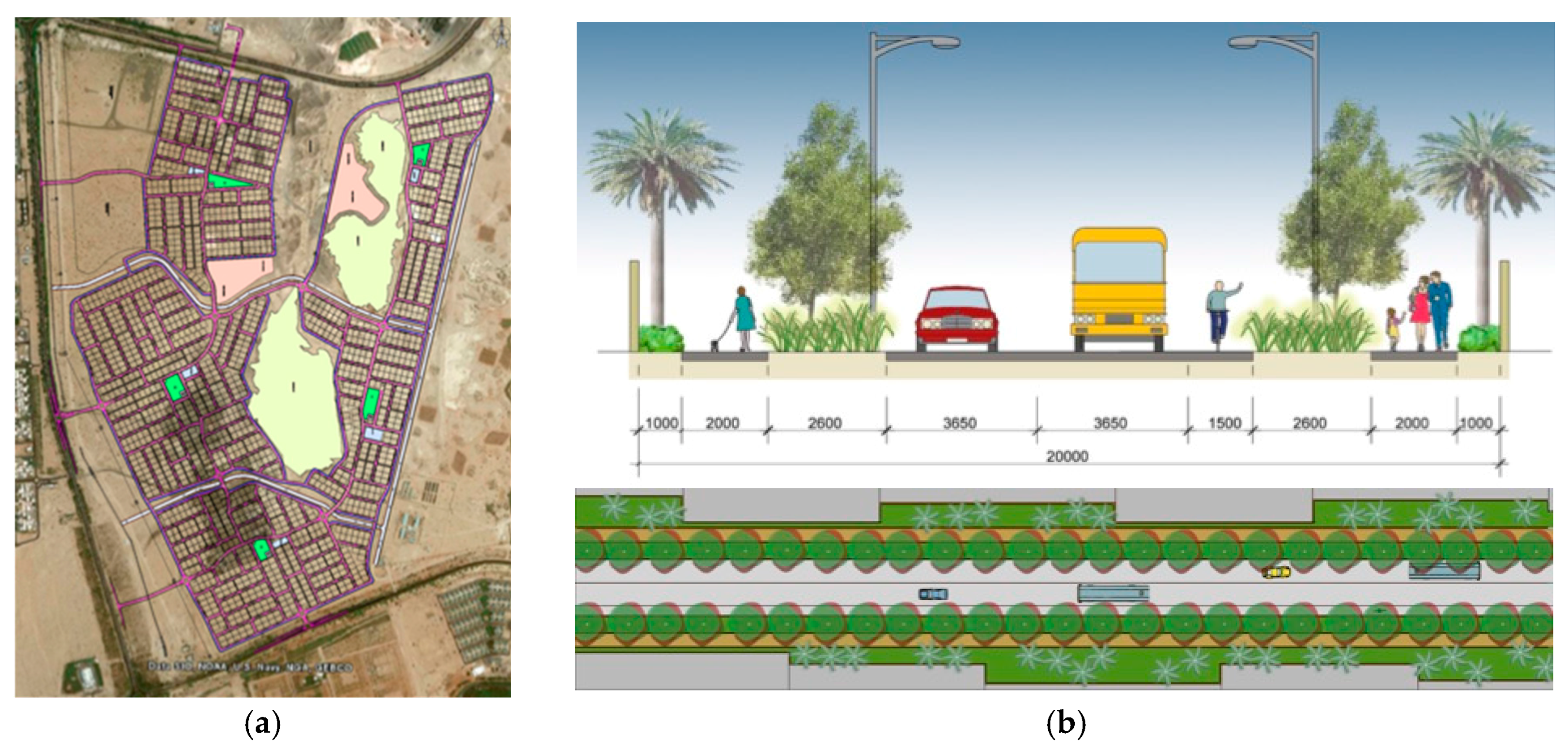
The main aim of the analysis of this recently designed and currently under development Shaubat Al Wattah social housing local community is to investigate to what extent its sustainability-orientated design has managed to bridge the sustainable urban form gaps found in Al Salamat, a conventional neighborhood. Shaubat Al Wattah is located on the southeast side of Al Ain City, about 15 km from the city center. It covers a total area of about 460 ha, encompassing 1580 single family houses in five housing clusters, as shown in Figure 7. Each housing cluster center contains a mosque, a kindergarten, some retail shops, and a playground.
4.2.1. Density/Compactness
The total targeted population is about 14,000 persons. The housing plot area is 30 m × 36 m, which is much smaller than in the conventional case study of Al Salamat (45 m × 45 m). This reflects a tendency towards a more compact and dense urban form. The gross population density is about 30.5 pph, which is remarkably higher than the gross population density of the conventional case study (11.3 pph). So, from a comparative point of view, the urban design of this neighborhood is more compact and much denser than the conventional one. However, it is still significantly less than the global standard of 50 to 60 pph. On the other hand, besides the five small housing clusters service areas (Figure 7), there is a planned mall located in the upper left corner in an area apparently not easily accessible by many residents, as discussed below.
The results of the assessment of these design elements indicate that the principle of Density/Compactness is “Marginally Considered”.
4.2.2. Accessibility
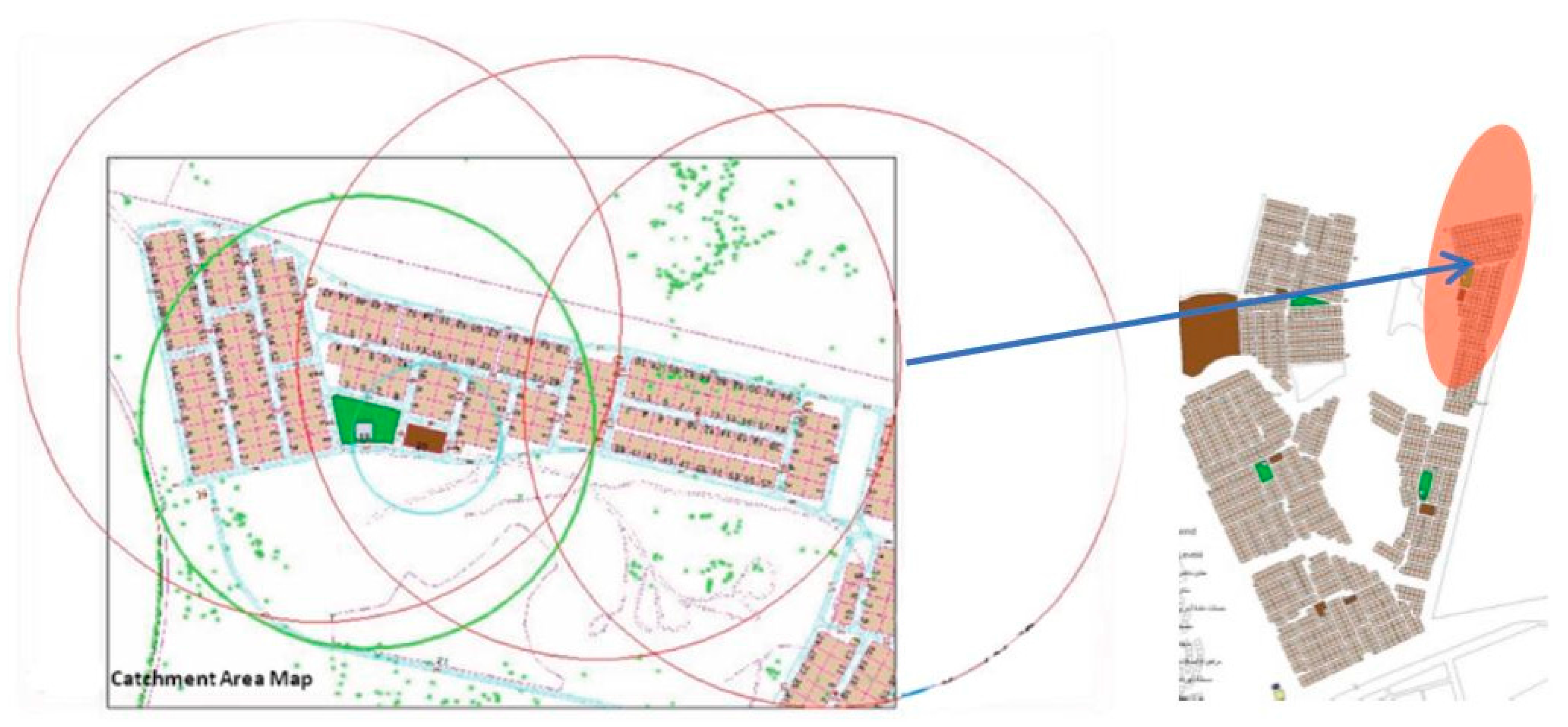
The decentralized distribution of the services and facilities needed daily made them accessible for many houses due to the adopted compact pattern of the urban form. Comparatively, the urban design of this case study has achieved better accessibility measures than the conventional one. Still, the neighborhood urban design does not fully respect the standard catchment areas as various services and facilities are not accessible by walking. As an example, the upper right side housing cluster (Figure 8) shows that the solely developed nursery is accessible by walking to about 12 h only, i.e., only 10% of the total villas in this cluster. Also, the playground area is accessible for about 70% of the houses in the same cluster. Meanwhile, the primary and secondary schools are located in far areas in the neighborhoods, thus reaching them necessitates long trips using private cars or buses. This applies to other clusters in one way or another.
Accessibility for less mobile categories has been included in the design such as wheelchair requirements at traffic intersections and so on. The urban design does not consider the high concentration of local services and facilities around the transport node (bus stops). Theoretically, buses routes are going to link the neighborhood clusters and services together with stop intervals of about 300 m. The proposed efficient bus routes are supposed to provide access to Al Ain city center. Still, public transport has no traffic priority or exclusive lanes. Additionally, a proper signage system is expected as is the case in the whole city of Al Ain. Accordingly, the results of the assessment of these design elements make this principle “Averagely Considered”.
4.2.3. Choice
There are limited options for services and facilities in this local community. Therefore, the reliance on private cars is high. Moreover, the neighborhood lacks many services including health centers, clinics, and private schools that would meet residents’ diversified needs. Unlike Al Salamat, the design here provides attractive pedestrian walkways and cycling lanes within a safe environment and distributed rest areas among walking paths. This would enable a choice between modes of travel. The catchment areas do not overlap with other neighborhoods and residents, similar to those of Al Salamat, and people will tend to use their private cars to reach services and facilities missing in their proximity.
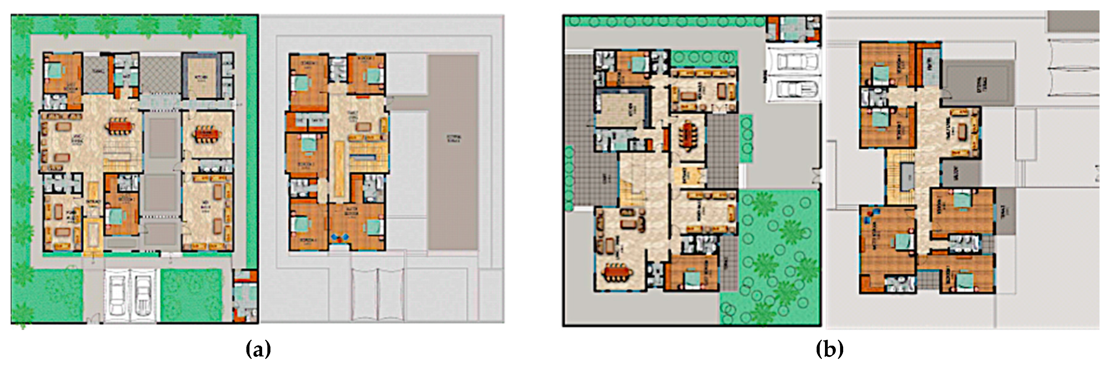
Diversification of housing types and sizes has been considered, but only for single-family houses, where nine design models were made available for residents to select from. The housing models reflect three different architectural styles, namely Islamic, Modern, and Traditional (Figure 9). Some house models have “stepless” entrances and other accessible features so that the handicapped and/or elderly people can select those designs. Other housing types, such as apartments, are not provided. So, the results of the assessment of these design elements point out that the Choice principle is “Averagely Considered”.
4.2.4. Mobility
The design of Shaubat Al Wuttah has achieved good integration between housing clusters within the neighborhood, housing clusters, and neighborhood services, services in each neighborhood, and between the neighborhood and the city (Figure 7). In accordance with the Al Ain 2030 Plan [24], the urban design of Shaubat Al Wuttah provides attractive pedestrian walkways within a safe environment and rest areas carefully distributed among walking paths. This is envisaged to encourage walking as an alternative mode of transport. Cycling paths are provided in the design as another alternative. Figure 10 shows a conceptual design for a primary collector road in Shaubat Al Wuttah with dedicated safe, shaded, well-lit, and pleasant pedestrian and cycling lanes. Nonetheless, as discussed above, the inappropriate catchment distances would make walking and cycling less favorable options and rather would encourage private car reliance as the primary mobility mode for residents.
There are bus stops planned, but they are not clearly defined yet. The streets would have traffic-calming measures. This integrated system of different modes of travel within the neighborhood’s road network, including pedestrian walkways, cycling paths, and bus stops, as shown in Figure 10, makes a big difference compared to the conventional neighborhood form. Furthermore, in the neighborhood design car parking lots have been decreased to promote the use of public transport. Actually, the number of parking lots exceeds 3160, which is still a considerable number and would not encourage residents to abandon using their own cars. The results of the assessment of these design elements make this principle “Significantly Considered”.
4.2.5. Mixed Use
The neighborhood design does not provide all the required services and facilities of daily life. Many of the designed services and facilities are not within the standard catchment area, which inevitably increases reliance on private cars. The neighborhood design does not provide suitably diverse and accessible job opportunities on the neighborhood level such as offices/workshops and, hence, the design is not catering for multi-function spaces and multi-function trips. The recommended areas of different mixed uses have not been achieved as residential use is still dominant, even with the introduction of the mall by the edge of the site. Similar to the Al Salamat conventional neighborhood, the multi-use of buildings for both commercial and housing purposes by, for example, providing housing over shops and service outlets is not considered here. Appropriate work places are not allowed either. The results of the assessment of these design elements render the Mixed Use principle “Marginally Considered”.
4.2.6. Social Mix/Social Capital
Housing plots here, as in Al Salamat, are identical in size, with no change in regulations. Meanwhile, as mentioned above, there are nine different housing unit models that residents can select from. The housing tenure type is similar to that of Al Salamat, where the government builds and delivers the houses to citizens with a low income. The provision of safe and attractive pedestrian walkways with landscaping and distributed rest areas in the design of Shubat Al Wuttah does not seem to actually encourage walkability and encounters between people, mainly due to the inappropriate catchment areas and the lack of diversified services and facilities, as mentioned earlier. Furthermore, the neighborhood design lacks sufficient public open spaces. There is only a playground area with a mosque within it, which minimizes opportunities for residents’ participation in any shared collective activities that might take place in such open public spaces. This, of course, will not encourage social relations and interactions among residents.
Based on the results of the assessment of these design elements, this principle can be considered “Marginally Considered”.
4.2.7. Adaptability/Resilience
For adaptability and resilience of the design models of single-family houses, originally there were only four different designs but they have been increased to nine in response to different user needs. Most designs have options for limited future extension. Figure 11 illustrates two examples of pre-designed expansions in the first floors of two house models.
Moreover, the unified plot area of Shaubat Al Wuttah was reduced to 30 m × 36 m, which made it impractical to extend it on the ground level. This obviously does not respond to diversified residents’ needs as they are forced to comply with the fixed pre-designed extensions. For adaptability on the urban scale, the provided roads, paths, and narrow squares do not actually cater for adaptive social and economic activities. The only vacant space in the middle of the development is the foothills of Hafeet Mountain (Figure 10). Accordingly, the results of the assessment of these design elements make this principle “Marginally Considered”.
4.2.8. Local Autonomy
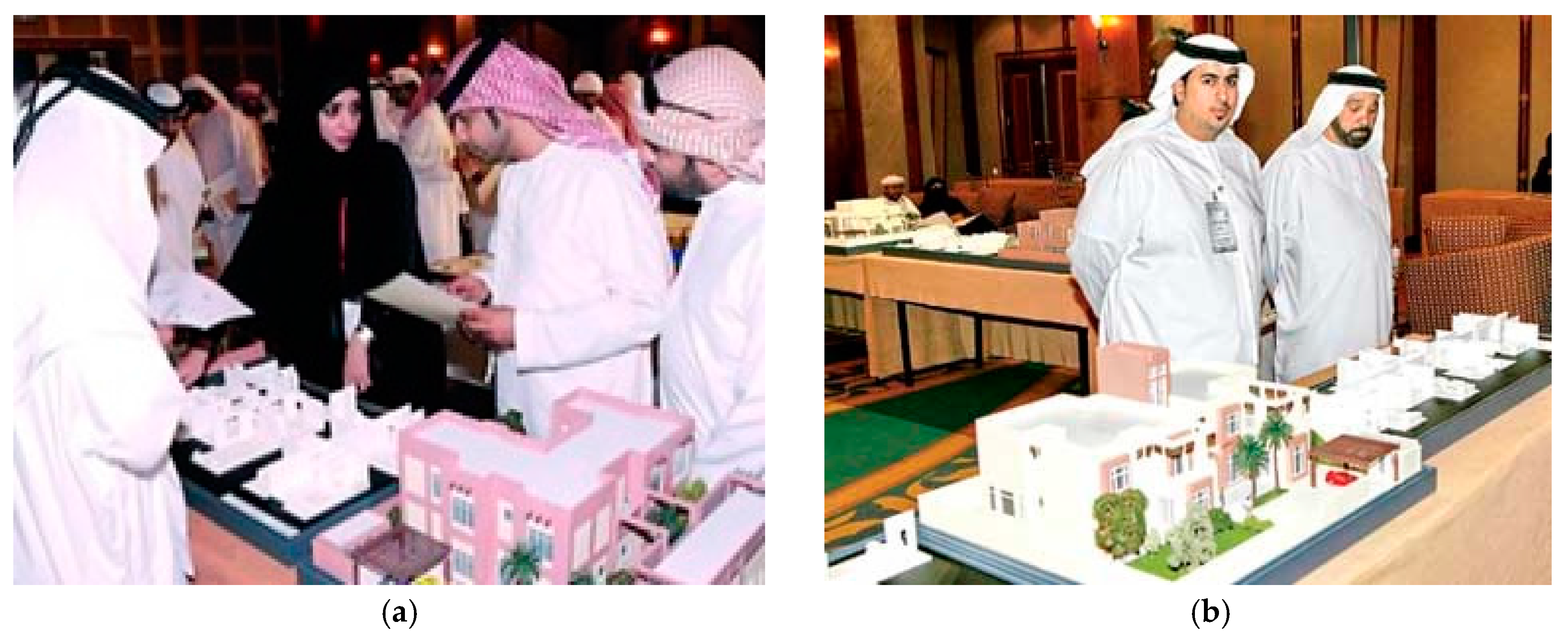
Another interesting point of comparison between Al Salamat and Shaubat Al Wuttah is the involvement of residents in the design stages of single-family houses of Shaubat Al Wuttah. For one week, Al Ain municipality and Al Dar consultancy firm held meetings with all prospective owners to discuss the design of the housing models (Figure 12). Most owners were satisfied with the designs of their houses after undertaking some suggested modifications. Nonetheless, there is no consideration for residents’ involvement in maintaining or managing local resources and projects such as the park and the sports field.
Local production of food is not mentioned in the design documents and it would be left to residents to cultivate some food if they wish in the small green areas inside their housing plots. Renewable energy resources have not been considered in the design either. The results of the assessment of these design elements indicate that the Local Autonomy principle is “Averagely Considered”.
4.2.9. Environmental Quality
As in the case of Al Salamat, environmental quality will suffer, though to a marginally lesser degree, from the heavy reliance on private cars. Locations of services within the neighborhood do not encourage residents to walk or cycle on attractive pedestrian pathways. On the contrary, insufficient services and activities mean that residents are more likely to use their cars for lengthy trips. Bus stops and stations, if properly located, might encourage people to use public transportation instead of their own cars. The location of Shaubat Al Wuttah near an industrial area (a cement factory) poses some environmental hazards but little effort to mitigate the effect of such a hazard is noted in the design. Some other measures have been introduced to enhance environmental quality, including highly energy-efficient street lighting. The results of the assessment of the design elements of the Environmental Quality principles indicate that it is “Significantly Considered”.
4.2.10. Community Safety
Street design in Shaubat Al Wuttah is generally safe as it considers safety zones and buffers to isolate pedestrian walkways from vehicular movement (Figure 10b). Visual surveillance in the public realm is expected to be better than in Al Salamat in light of these design measures but this would be affected by the lack of mixed use and inappropriate catchment areas, which will discourage residents’ presence in the streets. High fences are another obstacle to proper visual surveillance. Moreover, speed control signs and street humps within the neighborhood are expected to contribute to road safety. Facilities and services are designed to be accessible to children, the disabled, and older people, with ramps, signs, and other measures being considered. The results of the assessment of these design elements make this principle “Averagely Considered”.
4.2.11. Privacy
Unlike the conventional design in Al Salamat, the design of Shaubat Al Wuttah lacks wide open spaces within the housing plots. Other private spaces such as roof gardens and terraces are not considered in the design (Figure 9 and Figure 11). Based on the results of the assessment of these design elements, the Privacy principle can be considered “Marginally Considered”.
4.2.12. Imageability/Sense of Place/Identity
The unique urban design of Shaubat Al Wuttah might help create some distinguishable features and sets of activities that might take place in the small gardens. The architectural design of the houses reflects the historical and traditional architectural character of the UAE. However, consistency among the three adopted architectural design styles (Islamic, Modern, and Traditional) is questionable. On the other hand, the neighborhood location contains an important natural asset of Hafeet Mountain foothill that has not been considered in the urban design to help create a distinctive identity. The results of the assessment of these design elements make this principle “Averagely Considered”.
The overall results of the analysis of the urban design principles of Shaubat Al Wuttah local community are summarized in Table 2.
5. Discussion
The results of the analysis of the two social housing case studies—Al Salamat neighborhood representing the past convectional social housing projects in the UAE; and Shaubat Al Wuttah, representing the present turn towards sustainable-orientated social housing—have revealed positive and negative aspects relevant to urban forms with generally better but still insufficient moves towards sustainable urban forms in the recent design of Shaubat Al Wattah. Table 2 summarizes the challenges facing the realization of sustainable urban forms in the Shaubat Al Wuttah social housing project compared to the conventional neighborhood. It has been found that five principles are still marginally considered and five are averagely considered. Only two principles have been significantly considered in the urban form design. These results highlight the type of change in urban form design and its associated challenge, as seen in the last column in Table 2.
Accordingly, the four major challenges facing the turn towards sustainable urban design, not only in Shaubat Al Wuttah but in other new sustainability-orientated projects in the UAE, are ‘low density’, ‘lack of mixed use’, ‘lack of social mix’ and ‘lack of community participation’. The significance of low density comes from the fact that it adversely affects other principles such as choice, mobility (with public transportation), mixed use, and social mix/social capital. For example, the currently designed gross population density in Shaubat Al Wuttah would not be sufficient to support a feasible public transportation system and a mixed-use design.
Therefore, for the Density/Compactness principle, the aim should be to increase the gross density rate to be, as much as possible, closer to the global gross density of 50 to 60 pph. This could be achieved through introducing multi-story, medium-rise apartment blocks with multiple housing units. Insisting on single-family housing as the sole social housing pattern is not going to help produce sustainable urban forms, even if many other sustainability measures are applied. Multi-family housing can be introduced as another type of social housing for Emirati citizens alongside single-family housing when developing social housing neighborhoods. A real challenge here is going to be the local community’s acceptance of this type of housing, but with the recent development of some social housing projects in Al Fujairah and Al Ain it might be expected that an increasing number of Emirati citizens are getting closer to accepting living in apartments within multi-story residential blocks. Once intensified, density will help realize efficient public transport and economic vitality, which will, in turn, encourage diversification of services and utilities with a mixed-use design. Without achieving that, sustainable urban design will be difficult to realize.
The unappealing modes of mobility mainly result from inappropriate catchment areas because it is not enough for the design to provide pleasant and safe pedestrian walkways and cycling lanes to convince residents to leave their own cars behind and walk or cycle. Therefore, the neighborhood urban design should create standard catchment areas so that various services and facilities can be reached by different modes of travel, especially by walking and cycling. Again, without higher densities and more compact urban forms, catchment areas will remain wide and walkability and cycling would not be encouraged.
Choice can be enhanced through providing more options for services and facilities, but this needs to be thought about carefully in terms of the assumed population density that can support such variety. Mobility choice has been significantly improved with the introduction of different sustainable modes of travel within the neighborhood, but low density remains a concern for the economic feasibility of public transport. Therefore, increasing density, besides other regulative measures such as paid parking and positing taxes on fuel, are crucial measures for public transportation to function properly. Also, connections to other surrounding neighborhoods should be considered more in neighborhood urban design, as currently the most attention is given to individual neighborhood design without considering its possible relationship to its surrounding urban context.
Absence of social mix/social capital is an obvious shortcoming that can be rectified through diversification of housing types and enhancing the potential for residents to meet via locally organized social activities within the shared urban spaces and community facilities. Adaptability requires more attention on both the building and urban space levels. The development of pre-designed, limitedly expandable house models is not sufficient for achieving adaptability and resilience. Rather, there is a need for innovative design solutions that allow for various scenarios for expansion and adaptability according to the changing needs of the community. Residents should enjoy the ability to genuinely change or extend the residential spaces inside their homes, while urban spaces should be designed to accommodate various changing social and economic activities. Besides the provision of all required services and facilities, achieving local autonomy requires the involvement of community members in managing their neighborhood resources, including food production. Environmental quality requires more reliance on sustainable modes of travel such as walking, cycling, and public transport. To encourage people to walk or cycle, sufficient services and amenities should be provided, including working places, within a walkable distance from homes’ front doors in a mixed-use design pattern. Utilization of renewable energy resources and energy efficiency measures should be considered if a better environmental quality is to be achieved.
Community safety requires more urban surveillance through urging people to walk and cycle, and, as mentioned above, through developing a more dense and mixed-use residential built environment. Meanwhile, privacy can be enhanced by introducing more private spaces as wider green areas within the housing plots besides green roof and terraces. Finally, enhancing imageability, sense of place, and urban identity can be realized through developing architectural style(s) that are linked to the culture of the local community and through paying more attention to integrating natural assets within the urban design. More citizen involvement would lead to a greater sense of belonging and help produce a unique character for the local community shaped by the laypeople and not imposed on them in a form drawing-board-prepared design styles.
6. Conclusions
Federal and local social housing programs in the UAE are currently witnessing an ambitious and challenging turn from conventional neighborhood design paradigm, with its sprawl, low density and separate zoning, into design patterns that aim to accomplish sustainable urban form principles. This challenging turn has met with some success but it seems that there are still some major obstacles in the way that the new design failed to properly consider. These are ‘low population density’, ‘lack of mixed use’, ‘lack of social mix’ and ‘lack of community participation in the decision making and management of their neighborhoods’.
Higher density, design for mixed use, and social mix with genuine community participation would automatically enhance energy efficiency and cater for a variety of means of mobility in addition to widening the range of services and utilities choices for local residents. However, it should be acknowledged here that, as mentioned by the Smart Growth Network [17], local communities have different needs; therefore, the community residents are the ones who will emphasize some sustainable urban forms principles over others. Rectifying these obstacles and rethinking design concepts is by no means an easy task, but this seems to be the most plausible scenario for future actions.
As there are a limited number of social housing designs that adopt the sustainability agenda in the UAE, it is believed that the analysis of further design models would enrich the argument raised by this research. Nonetheless, it is believed that the results of this investigation would pave the way for a futuristic urban design scenario that, if adopted, will lead to a more sustainable urban form of social housing in the UAE and maybe in other Gulf Cooperation Council (GCC), Arab, and Middle Eastern countries that share many environmental, social, and economic circumstances and for which the UAE is a role model in terms of sustainable policies and actions.
Acknowledgments
The author would like to thank the United Arab Emirates University for funding this research through its Center-based Funding Program-Grant No. 31R104. Also, the author appreciates the effort and dedication of Architectural Engineering Master students in collecting data for this research.
Conflicts of Interest
The author declares no conflict of interest.
References
- Burton, E.; Jenks, M.; Williams, K. Achieving Sustainable Urban Form; Routledge: London, UK, 2013. [Google Scholar]
- American Society of Landscape Architects. Professional Practice: Sustainable Urban Development. Available online: https://www.asla.org/sustainableurbandevelopment.aspx (accessed on 13 February 2017).
- Handy, S.; Niemeier, D. Measuring accessibility: An exploration of issues and alternatives. Environ. Plan. A 1997, 29, 1175–1194. [Google Scholar] [CrossRef]
- Neuman, M. The Compact City Fallacy. J. Plan. Educ. Res. 2005, 25, 11–26. [Google Scholar] [CrossRef]
- Frey, H. Designing the City: Towards a More Sustainable Urban Form; Spon Press: London, UK, 1999. [Google Scholar]
- Allen, A. Sustainable Cities or Sustainable Urbanisation? Palette, UCL’s Journal of Sustainable Cities. Available online: http://discovery.ucl.ac.uk/1353511/ (accessed on 10 May 2017).
- The Emirates Center for Strategic Studies and Research. Governmental Housing Strategies in the GCC and Some European Countries; The Emirates Center for Strategic Studies and Research: Abu Dhabi, UAE, 2009. [Google Scholar]
- Unified Housing Portal. Available online: http://www.iskan.gov.ae/Home.aspx (accessed on 13 July 2017).
- Ahmed, K.G. Urban social sustainability: A study of the Emirati local communities in Al Ain. J. Urban. Int. Res. Placemaking Urban Sustain. 2012, 5, 41–66. [Google Scholar] [CrossRef]
- Jenks, M.; Burgess, R. (Eds.) Compact Cities: Sustainable Urban Forms for Developing Countries; Spon Press: London, UK, 2000. [Google Scholar]
- Jabareen, Y. Sustainable Urban Forms: Their Typologies, Models, and Concepts. J. Plan. Educ. Res. 2006, 26, 38–52. [Google Scholar] [CrossRef]
- Jones, C.; MacDonald, C. Sustainable Urban Form and Real Estate Markets. In Proceedings of the Annual European Real Estate Conference, Milan, Italy, 2–5 June 2004. [Google Scholar]
- Coppolaa, P.; Papab, E.; Angielloc, G.; Carpentieric, G. Urban Form and Sustainability: The Case Study of Rome. Procedia Soc. Behav. Sci. 2014, 160, 557–566. [Google Scholar] [CrossRef]
- Dempsey, N.; Brown, C.; Bramley, G. The key to sustainable urban development in UK cities? The influence of density on social sustainability. Prog. Plan. 2012, 77, 89–141. [Google Scholar] [CrossRef] [Green Version]
- Barton, H. (Ed.) Sustainable Communities; Earthscan Publications Ltd.: Cambridge, UK, 2000. [Google Scholar]
- CNU (Congress for New Urbanism). The Charter of the New Urbanism: The Neighborhood, the District, and the Corridor. Available online: https://www.cnu.org/who-we-are/charter-new-urbanism (accessed on 11 July 2017).
- Smart Growth Network. Smart Growth Principles. Available online: http://smartgrowth.org/smart-growth-principles/ (accessed on 11 July 2017).
- Sustainable Cities Institute. Traditional Neighborhood Development (TND). Available online: http://www.sustainablecitiesinstitute.org/topics/land-use-and-planning/traditional-neighborhood-development-(tnd) (accessed on 12 July 2017).
- Transit Oriented Development Institute (2017) Transit Oriented Development 10 Principles. Available online: http://www.tod.org/placemaking/principles.html (accessed on 10 July 2017).
- UN Habitat. A New Strategy of Sustainable Neighborhood Planning: Five Principles, Discussion Note 3 Urban Planning. May 2014. Available online: https://unhabitat.org/Wp-content/uploads/2014/05/5-Principles_web.pdf (accessed on 17 July 2017).
- Center for Liveable Cities. 10 Principles for Liveable High-Density Cities; Centre for Liveable Cities and Urban Land Institute: Singapore, 2013. [Google Scholar]
- Burke, M.; Brown, A.L. Distances people walk for transport. Road Transp. Res. 2007, 16, 16–29. [Google Scholar]
- Biddulph, M. Introduction to Residential Layout; Butterworth-Heinemann: Oxford, UK, 2007. [Google Scholar]
- ADUPC (Abu Dhabi Urban Planning Council). Plan Al Ain 2030 Urban Structure Framework Plan; ADUPC: Abu Dhabi, UAE, 2009. [Google Scholar]
Figure 1.
The Applied Qualitative Research Method and Its Tools.

Figure 2.
Al Salamat Community and Its Planned Land Use. (Source: Google Earth).
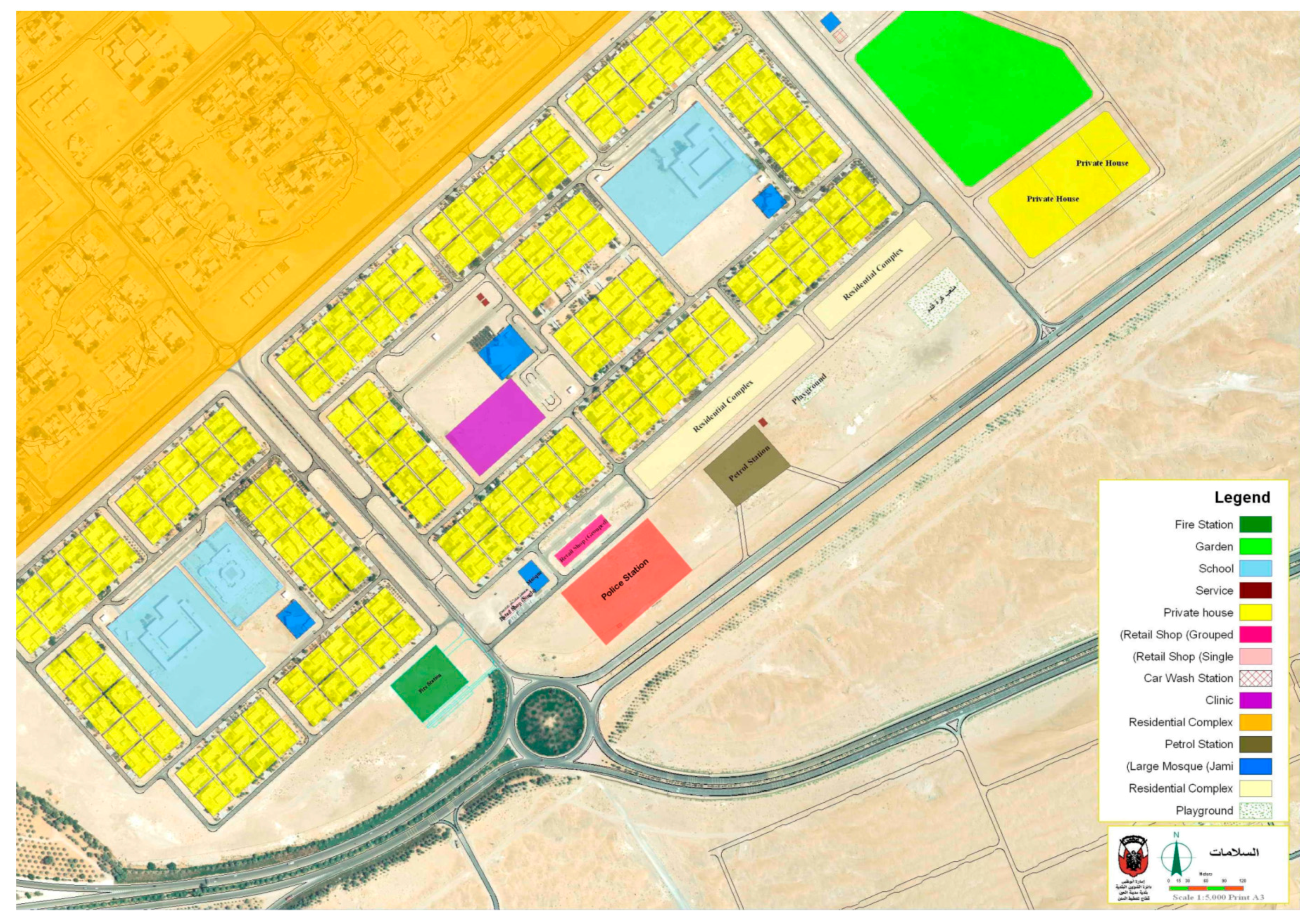
Figure 3.
(a–c) Low density and Sprawl Design of Al Salamat.

Figure 4.
Limited Choices of Services and Utilities in Al Salamat. (Source: Google Earth & the Author).
Figure 4.
Limited Choices of Services and Utilities in Al Salamat. (Source: Google Earth & the Author).
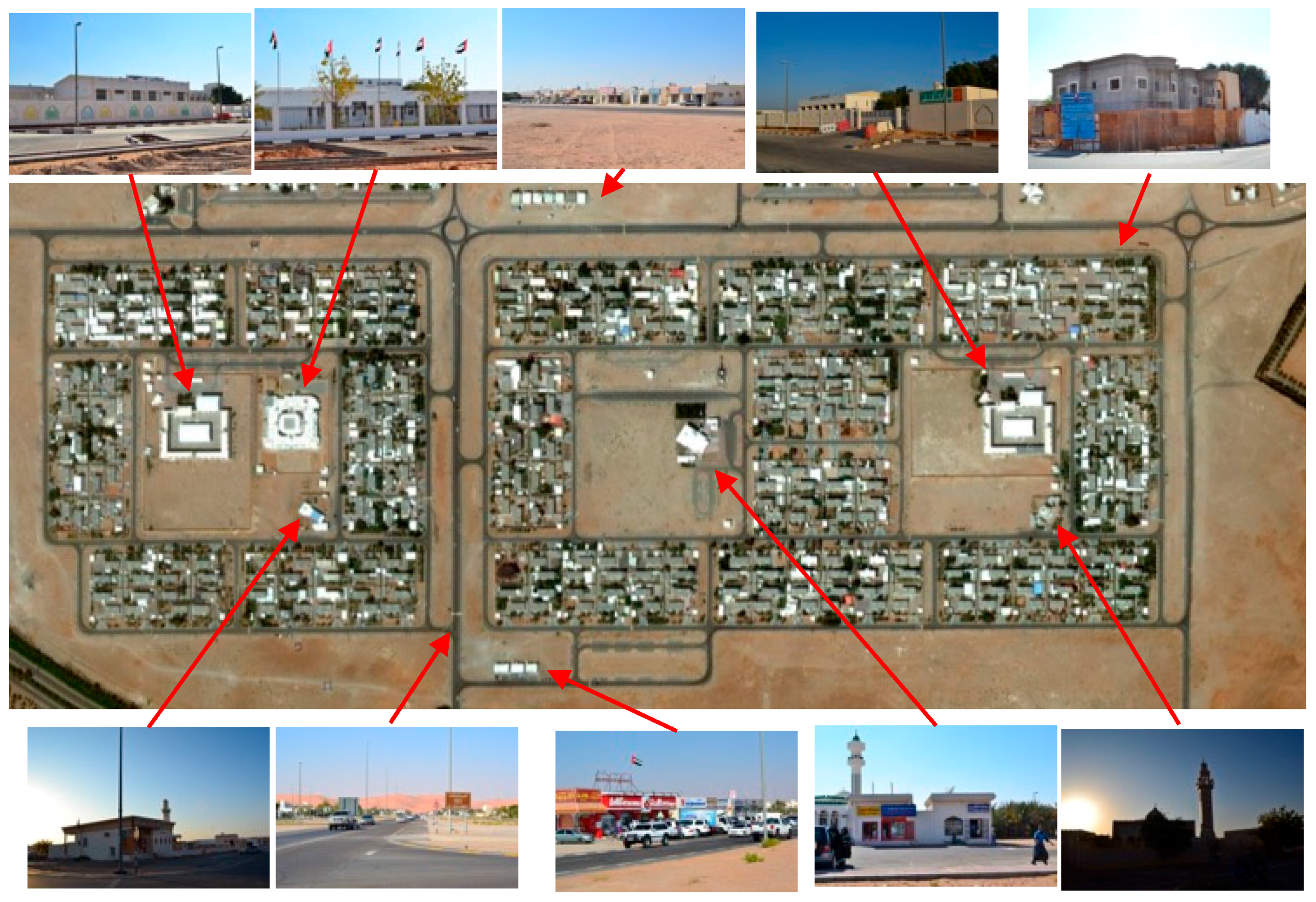
Figure 5.
Mobility Modes in Al Salamat, (a,b) Insufficient Public Transportation Nodes; (c) Lack of Pedestrian and Cycling Lanes and (d) Car-oriented Mobility.
Figure 5.
Mobility Modes in Al Salamat, (a,b) Insufficient Public Transportation Nodes; (c) Lack of Pedestrian and Cycling Lanes and (d) Car-oriented Mobility.

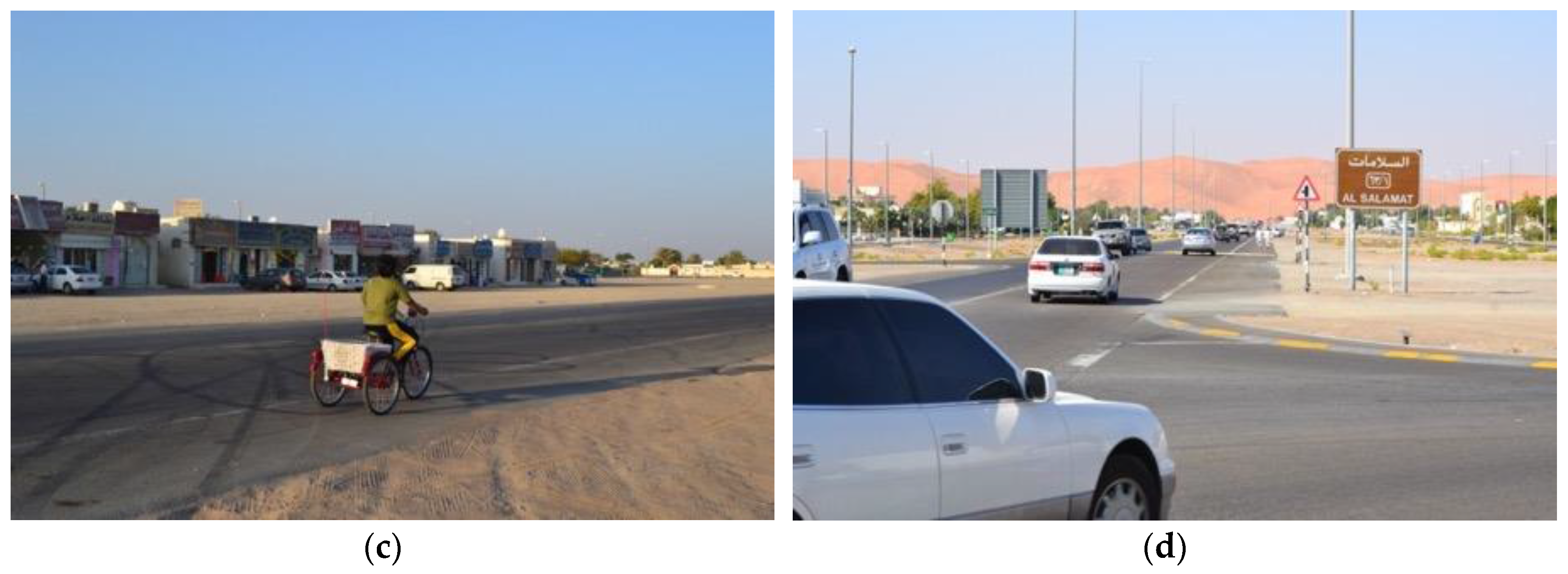
Figure 6.
Safety Issues in Al Salamat: (a) in-between Spaces among Fences of the Housing Plots; (b) Shortcuts Made by Private Car Drivers through Unutilized Open Spaces.
Figure 6.
Safety Issues in Al Salamat: (a) in-between Spaces among Fences of the Housing Plots; (b) Shortcuts Made by Private Car Drivers through Unutilized Open Spaces.
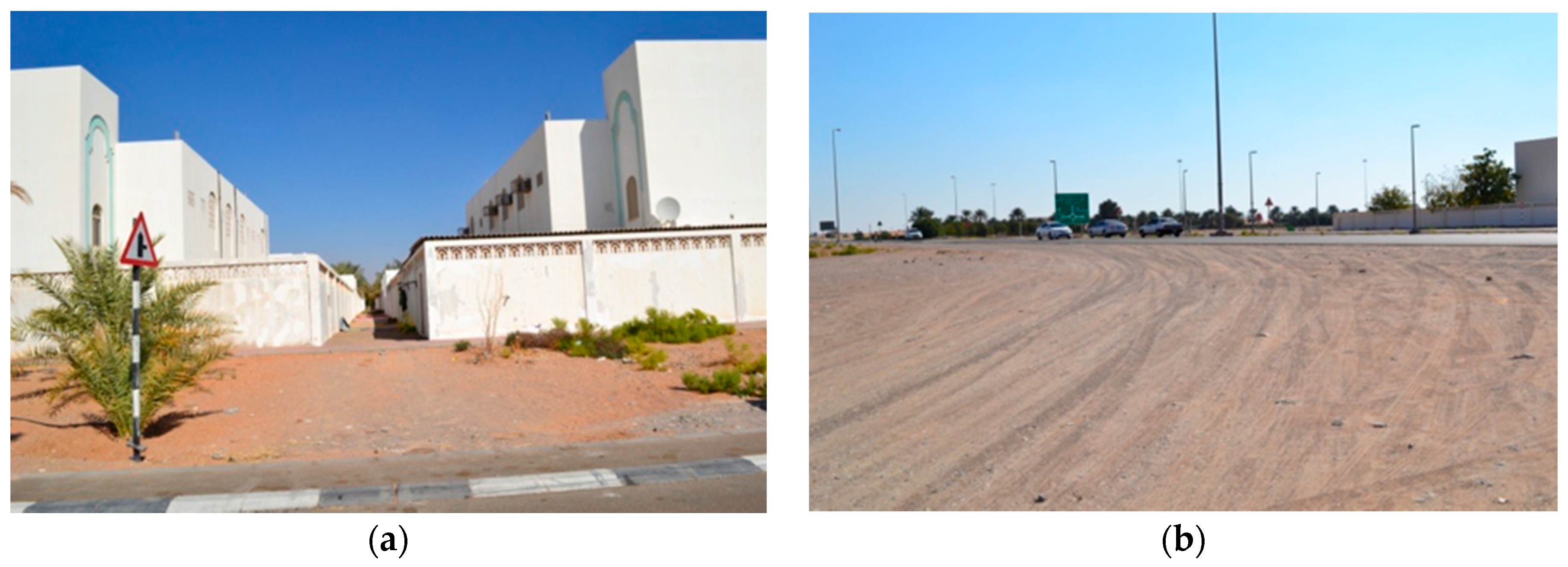
Figure 7.
Shaubat Al Wuttah Community: (a) Plots and Services; (b) Perspective Showing the Designed Community Services; and (c) Arrangement of Housing Plots. (Source: Al Ain Municipality).
Figure 7.
Shaubat Al Wuttah Community: (a) Plots and Services; (b) Perspective Showing the Designed Community Services; and (c) Arrangement of Housing Plots. (Source: Al Ain Municipality).
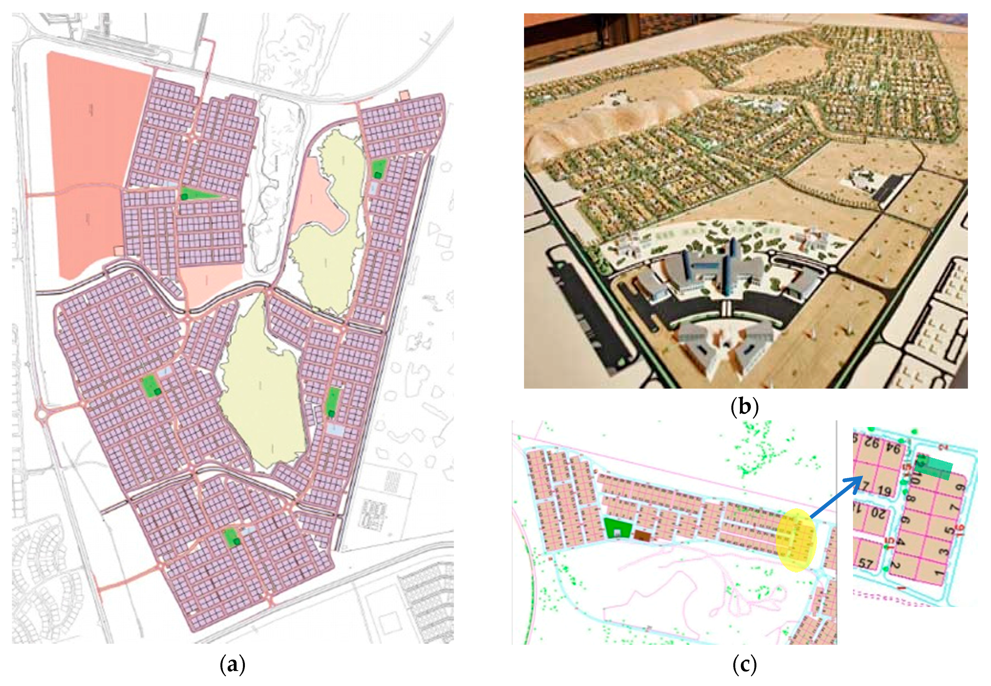
Figure 8.
Catchment Areas in a Housing Cluster in Shaubat Al Wuttah Local Community. (Source: Al Ain Municipality).
Figure 8.
Catchment Areas in a Housing Cluster in Shaubat Al Wuttah Local Community. (Source: Al Ain Municipality).

Figure 9.
Architectural Styles of the Housing Models in Shaubat Al Wuttah Local Community Project. (Source: Al Ain Municipality).
Figure 9.
Architectural Styles of the Housing Models in Shaubat Al Wuttah Local Community Project. (Source: Al Ain Municipality).
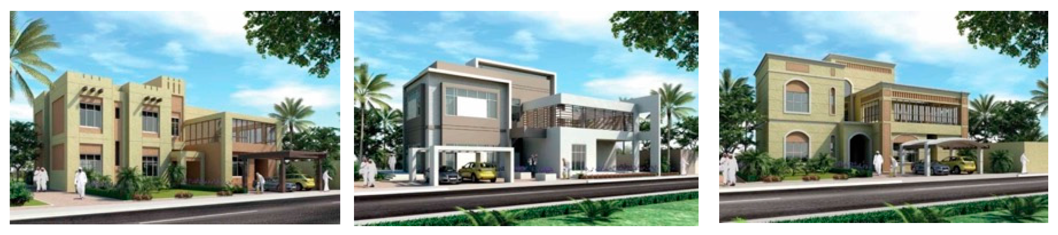
Figure 10.
(a) Road Network; (b) Section and Plan for A Primary Collector Road in Shaubat Al Wuttah. (Source: Al Ain Municipality).
Figure 10.
(a) Road Network; (b) Section and Plan for A Primary Collector Road in Shaubat Al Wuttah. (Source: Al Ain Municipality).

Figure 11.
Two Typical House Models in Shaubat Al Wuttah Urban Community: (a) Ground Floor and (b) First Floor Plans. The Expandable Area is Shown in Dark Gray on the First Floor. (Source: Al Ain Municipality).
Figure 11.
Two Typical House Models in Shaubat Al Wuttah Urban Community: (a) Ground Floor and (b) First Floor Plans. The Expandable Area is Shown in Dark Gray on the First Floor. (Source: Al Ain Municipality).

Figure 12.
(a,b) Discussing Housing Designs with Residents. (Source: Al Ain Municipality).

Table 1.
A Conceptual Design Matrix for Sustainable Urban Form (Sources: References in Section 3).
Table 1.
A Conceptual Design Matrix for Sustainable Urban Form (Sources: References in Section 3).
| Principal | Design Elements |
|---|---|
| Density/Compactness |
|
| Accessibility |
|
| Choice |
|
| Mobility |
|
| Mixed Use |
|
| Social Mix/Social Capital |
|
| Adaptability/Resilience |
|
| Local Autonomy |
|
| Environmental Quality |
|
| Community Safety and Security |
|
| Privacy |
|
| Imageability/Sense of Place/Identity |
|
Table 2.
Assessment of the Consideration of Sustainable Urban Form Design Principles in Both Al Salamat and Shaubat Al Wuttah.
Table 2.
Assessment of the Consideration of Sustainable Urban Form Design Principles in Both Al Salamat and Shaubat Al Wuttah.
| Principle | Al Salamat, Conventional Neighborhood. | Shaubat Al Wuttah, Claimed as Sustainable Neighborhood. | Type of Change in Urban Form Design (Challenges) |
|---|---|---|---|
| Density/Compactness | Marginally Considered | Marginally Considered | Inadequate |
| Accessibility | Marginally Considered | Averagely Considered | Better but Insufficient |
| Choice | Marginally Considered | Averagely Considered | Better but Insufficient |
| Mobility | Marginally Considered | Significantly Considered | Appropriate |
| Mixed Use | Marginally Considered | Marginally Considered | Inadequate |
| Social Mix/Social Capital | Marginally Considered | Marginally Considered | Inadequate |
| Adaptability/Resilience | Averagely Considered | Marginally Considered | Inadequate |
| Local Autonomy | Not Considered | Averagely Considered | Better but Insufficient |
| Environmental Quality | Averagely Considered | Significantly Considered | Appropriate |
| Community Safety | Averagely Considered | Averagely Considered | Better but Insufficient |
| Privacy | Significantly Considered | Marginally Considered | Better but Insufficient |
| Imageability/Sense of Place/Identity | Marginally Considered | Averagely Considered | Better but Insufficient |
© 2017 by the author. Licensee MDPI, Basel, Switzerland. This article is an open access article distributed under the terms and conditions of the Creative Commons Attribution (CC BY) license (http://creativecommons.org/licenses/by/4.0/).
Share and Cite
MDPI and ACS Style
Ahmed, K.G. Designing Sustainable Urban Social Housing in the United Arab Emirates. Sustainability 2017, 9, 1413. https://doi.org/10.3390/su9081413
AMA Style
Ahmed KG. Designing Sustainable Urban Social Housing in the United Arab Emirates. Sustainability. 2017; 9(8):1413. https://doi.org/10.3390/su9081413
Chicago/Turabian StyleAhmed, Khaled Galal. 2017. "Designing Sustainable Urban Social Housing in the United Arab Emirates" Sustainability 9, no. 8: 1413. https://doi.org/10.3390/su9081413
Note that from the first issue of 2016, this journal uses article numbers instead of page numbers. See further details here.