ISPRS Int. J. Geo-Inf. 2020, 9(11), 665; https://doi.org/10.3390/ijgi9110665 - 4 Nov 2020
Cited by 17 | Viewed by 3740
Abstract
►
Show Figures
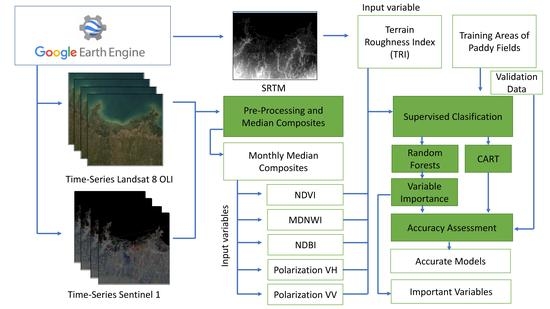
Spatio-temporal fusion algorithms dramatically enhance the application of the Landsat time series. However, each spatio-temporal fusion algorithm has its pros and cons of heterogeneous land cover performance, the minimal number of input image pairs, and its efficiency. This study aimed to answer: (1)
[...] Read more.
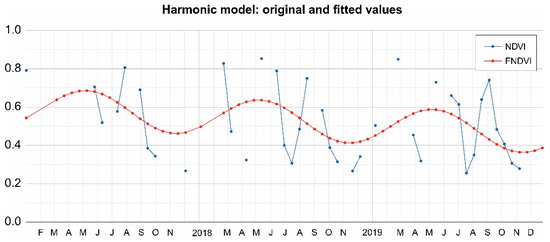
Spatio-temporal fusion algorithms dramatically enhance the application of the Landsat time series. However, each spatio-temporal fusion algorithm has its pros and cons of heterogeneous land cover performance, the minimal number of input image pairs, and its efficiency. This study aimed to answer: (1) how to determine the adaptability of the spatio-temporal fusion algorithm for predicting images in prediction date and (2) whether the Landsat normalized difference vegetation index (NDVI) time series would benefit from the interpolation with images fused from multiple spatio-temporal fusion algorithms. Thus, we supposed a linear relationship existed between the fusion accuracy and spatial and temporal variance. Taking the Spatial and Temporal Adaptive Reflectance Fusion Model (STARFM) and the Enhanced STARFM (ESTARFM) as basic algorithms, a framework was designed to screen a spatio-temporal fusion algorithm for the Landsat NDVI time series construction. The screening rule was designed by fitting the linear relationship between the spatial and temporal variance and fusion algorithm accuracy, and then the fitted relationship was combined with the graded accuracy selecting rule (R2) to select the fusion algorithm. The results indicated that the constructed Landsat NDVI time series by this paper proposed framework exhibited the highest overall accuracy (88.18%), and lowest omission (1.82%) and commission errors (10.00%) in land cover change detection compared with the moderate resolution imaging spectroradiometer (MODIS) NDVI time series and the NDVI time series constructed by a single STARFM or ESTARFM. Phenological stability analysis demonstrated that the Landsat NDVI time series established by multiple spatio-temporal algorithms could effectively avoid phenological fluctuations in the time series constructed by a single fusion algorithm. We believe that this framework can help improve the quality of the Landsat NDVI time series and fulfill the gap between near real-time environmental monitoring mandates and data-scarcity reality.
Full article

Figure 1


