Review

Stratigraphy, Tectonics and Hydrocarbon Habitat of the Abadan Plain Basin: A Geological Review of a Prolific Middle Eastern Hydrocarbon Province

1
Department of Petroleum Engineering, College of Engineering and Mines, University of Alaska Fairbanks, Fairbanks, AK 99775, USA
2
Australian School of Petroleum, The University of Adelaide, Adelaide, South Australia 5005, Australia
*
Author to whom correspondence should be addressed.
Geosciences 2018, 8(12), 496; https://doi.org/10.3390/geosciences8120496
Submission received: 21 October 2018 / Revised: 22 November 2018 / Accepted: 5 December 2018 / Published: 17 December 2018
(This article belongs to the Special Issue Stress Quantification in Sedimentary Basins)

Abstract

:
The Abadan Plain Basin is located in the Middle East region which is host to some of the world’s largest oil and gas fields around the Persian Gulf. This basin is a foredeep basin to the southwest of the Zagros Fold-Thrust-Belt, bounded along its northern and eastern margins by the Dezful Embayment. Most of the rocks in this basin have been deposited in a carbonate environment, and existing fractures have made the formations a favourable place for hydrocarbon accumulations. The basin is enriched by oil and, therefore, gas reservoirs are few, and some of the explored reservoirs exhibit significant degrees of overpressure. This paper has compiled several aspects of the Abadan Plain Basin tectonics, structural geology and petroleum systems to provide a better understanding of the opportunities and risks of development activities in this region. In addition to the existing knowledge, this paper provides a basin-wide examination of pore pressure, vertical stress, temperature gradient, and wellbore stability issues.

1. Introduction

Zagros foreland sediments and surrounding basins in the Middle East are host to some of the world’s greatest oil and gas accumulations [1,2,3]. The conditions that facilitated the formation of oil and gas traps in this region include extensive folding along the Zagros Orogeny and a lack of metamorphic activities [4,5,6,7,8]. The Abadan Plain Basin, located at the north-western corner of the Persian Gulf (Figure 1), is one of the most prolific hydrocarbon basins in this region and is also one of the first regions in the Middle East from which oil was commercially produced. Carbonate sedimentation is a common characteristic of the late Carboniferous to Miocene sequences of this region which are dominated by carbonate sedimentation on a broad platform. Hydrocarbon traps in the shallow-marine, carbonate-dominated basin of the Abadan Plain have been formed in pre–Zagros Orogeny structures, and then deformed and geometrically controlled by the Cretaceous tectonics such as Arabia–Eurasia plate collision [9]. Zagros Orogeny, and its associated folding as a result of Arabia-Eurasia plate collision, comprise a large proportion of the hydrocarbon accumulations of the Middle East region, the world’s richest hydrocarbon habitat [10]. In this region, gas plays are mainly formed in some of the Permian–Triassic platform successions’ mega-sequences [11], while the main petroleum sources and reservoir rocks have been formed in those of the Jurassic to the present [12,13,14].
The first commercial oil production in the Middle East was from the Dezful Embayment, immediately adjacent to the Abadan Plain Basin, which was commissioned in 1908 and is still producing today [15]. Hydrocarbon exploration within the Abadan Plain Basin commenced in 1948 in the Iraqi side of the basin [16], and in 1964 on the Iranian side [17]. At the time of writing, the Abadan Plain Basin contains over 20 producing hydrocarbon fields, with the majority of fields located onshore in the middle and northern parts of the basin, but with some also located offshore (Figure 1). Major reservoir formations of this basin include the Asmari, Sarvak, Gadvan and Fahliyan formations. However, there are still numerous uncertainties about the geology of the Abadan Plain Basin, and the area is known for numerous drilling risks such as its difficulty to predict high magnitude pore pressures [18], all of which need to be addressed for the basin to reach its full potential production rate of over 1 million barrels per day.
This study aims to provide a detailed summary of the geology of the Abadan Plain Basin, with particular focus on the region’s stratigraphic and tectonic framework, and to explain how these components have resulted in the formation of a petroleum province of global importance. This study further reviews the tectonic development of the basin, ranging from large plate-scale processes down to small scale processes that have resulted in the formation and charging of structural traps. As an addition to the existing knowledge about this basin, some of its unique characteristics such as pore pressure, temperature gradient, overburden stresses, and wellbore stability issues are herein examined.
This study will first review the geological setting of the basin and its relationship and key differences with other major petroleum provinces in Iran, Iraq and the Arabian Plate. We then describe the stratigraphy of the Abadan Plain Basin, including identifying how the depositional environment has changed over time, as well as identifying key reservoir and seal formations. Then the tectonic history of the basin and surrounding areas are reviewed, which is followed by an examination of the overburden stresses and observed overpressures. Finally, Hydrocarbon geochemistry of several reservoir formations in this basin is explained to better describe the type of reservoirs and the potential production of the basin.

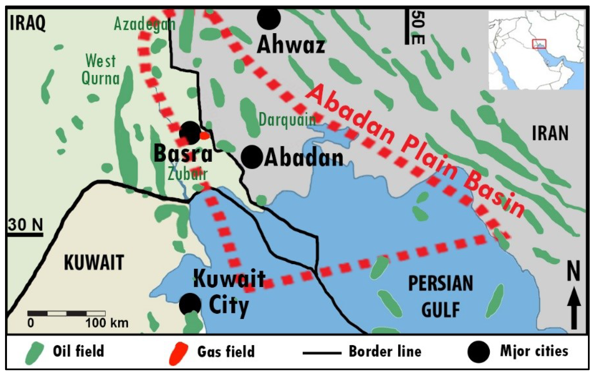
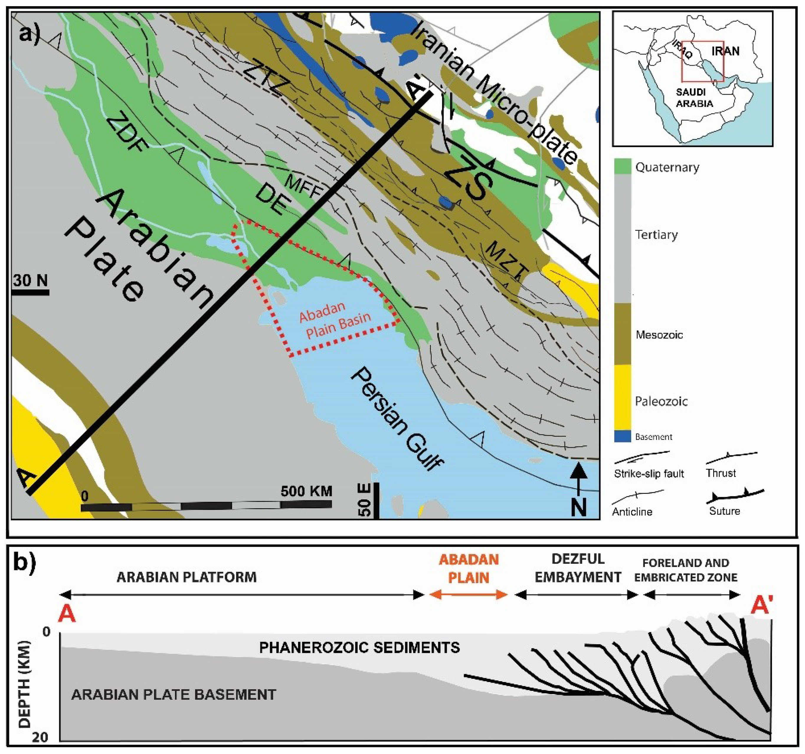
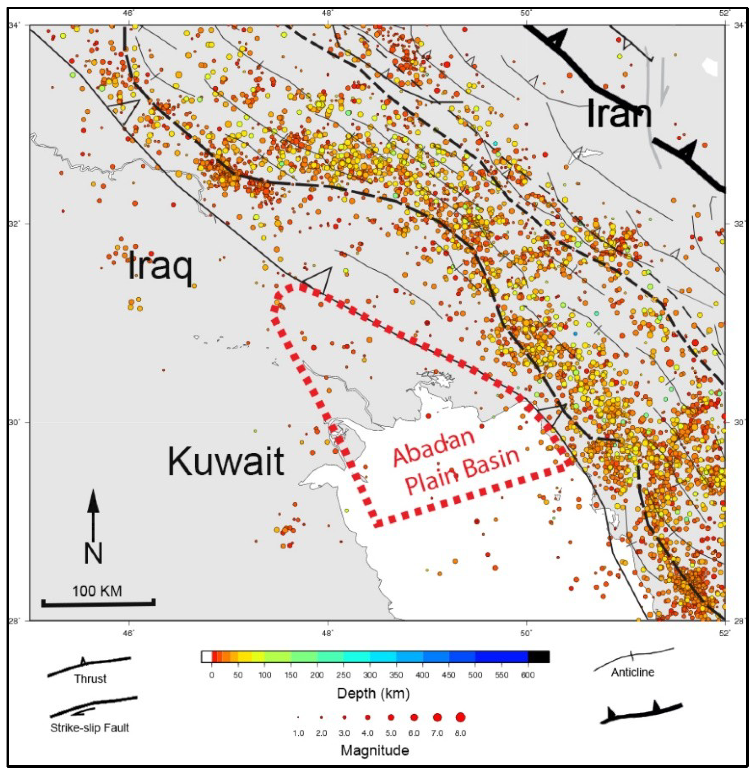
2. Geological Setting of the Abadan Plain Basin

The Abadan Plain Basin is located in the area covering the southwest of Iran, southeast of Iraq, and west offshore of Kuwait. It is a foredeep basin to the southwest of the Zagros Fold-Thrust-Belt (ZFTB), located at the outer edge of the Zagros deformation front and adjacent to the Persian Gulf–Mesopotamian foreland basin (Figure 2; [19,20]) that was affected during the Miocene and Pliocene era [21]. The Zagros orogeny has begun in the middle Maastrichtian [19] and has led to formation of the Zagros Thrust Front in mid-Miocene [21].
This basin is bounded along its northern and eastern margin by the Dezful Embayment (Figure 2). It extends into Iraq at its northern end and into the Persian Gulf to the south (Figure 2). A wider area has also been defined by Moallemi and Kermanshah [22] for this basin which covers almost all areas of Kuwait and northern Persian Gulf extending towards Saudi Arabia. There are some similarities between the geological structures (such as depth to basement and trend of anticlines) in such wider areas, as will be discussed later. However, the narrower definition, as an area between the Zagros Deformation Front and west of the Iran–Iraq border is accepted here. There is currently no agreement on the southern boundary of this basin. To define the area extent, we looked for structural trend similarities in the region, and found some trends. As such, the basin is believed to be extended towards the northern margin of the Persian Gulf, covering some of the offshore fields as well (Figure 2; [9,23]). The north-west end of the Persian Gulf is often considered as a part of the Abadan Plain Basin [9,23], and due to hydrodynamic connections between some structures on both sides of the border, this definition of the basin covers a narrow margin in the south of Iraq (Figure 2).
There are a few independent studies on the structures of the Abadan Plain Basin, while this basin was generally considered through studies of the Zagros Fold-Thrust-Belt or in conjunction with the Dezful Embayment in particular. The geology of this basin is primarily controlled by the Zagros Orogeny, and is associated with the collision between the Arabian and Eurasian Plates. Therefore, geological explanation of the Abadan Plain comes from a comprehensive study of such collisional-related tectonics. The lack of unique investigation of the Abadan Plain Basin has become one of the drivers to study more attributes of a basin that is one of the region’s most prolific hydrocarbon environments.
According to British Petroleum [25], the Middle East is the host to nearly 48% of the world’s proven conventional oil reserves and 43% of world’s proven conventional gas reserves. A vast majority of these reserves (and almost all of the giant fields) are placed on the Arabian plate or across the Zagros folded area. Some specific conditions that gave rise to the current basin could be noted as [26]:
  • Almost continuous deposition of limestone, argillaceous limestone, marly limestone, and evaporites from Permian up to Pliocene in a marine environment;
  • existing source rock, reservoir and cap rock in adequate placement;
  • lack of intense tectonic activities during the period of Permian up to Pliocene (post collision tectonic settings), and;
  • lack of metamorphic or magmatic activity since the Permian.
The southern part of Eurasia, that includes Iran, is often considered to have been a stable block which was affected by only gentle epeirogenic movements, Zagros Fold-Thrust-Belt, throughout the Palaeozoic [27]. As such, the Abadan Plain Basin has different attributes from the Zagros Fold-Thrust-Belt, such as less seismicity and lack of anticlinal expressions at the surface. Moreover, the majority of anticlines in the Abadan Plain Basin have N-S oriented axes, similar to the structures in Kuwait, north of Persian Gulf and northeast of Saudi Arabia [28], while those in the Zagros area are primarily oriented NW to SE due to plate collision.

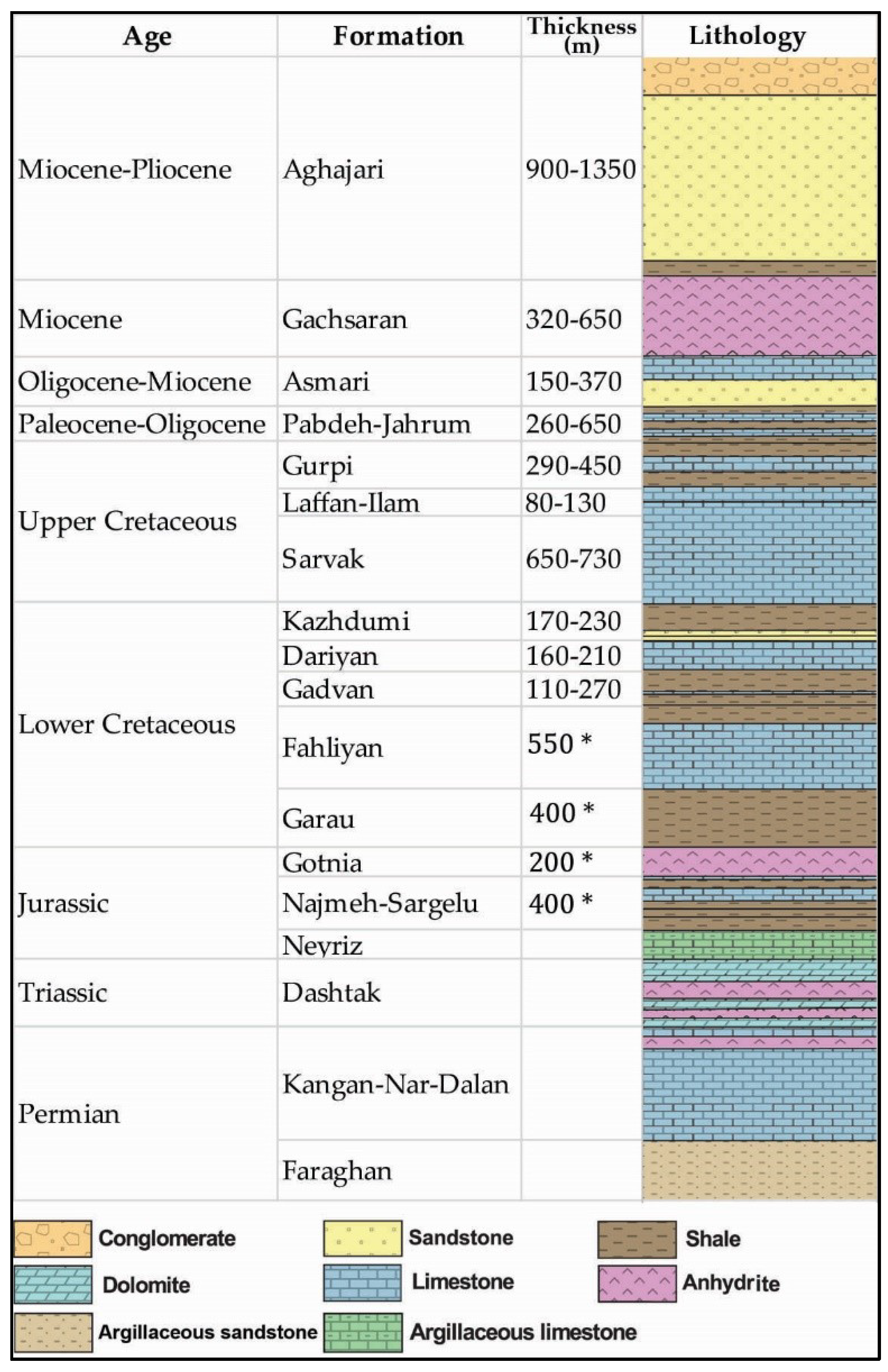
3. Abadan Plain Basin Stratigraphy

The majority of the sediments in the Middle East are marine sequences deposited in the Tethys marine environment. The Hormuz salt formation lies immediately above the Pan-African basement and is extensive over the entire region. Jurassic to Permian deposits consist of three types of evaporites, carbonates and shales, while sandstone and conglomerates are present in the older horizons. From Eocene to Cretaceous, deposits are several combinations of carbonate and clay/shales with minor sandstone interlayers. Shallow marine to non-marine deposits (present to Oligocene) mainly consist of sandstone, conglomerates and evaporites. There are a few outcrops of deep formations in the Abadan Plain Basin and the surface in this region mostly consists of Quaternary alluvial deposits [29].
Several clay type formations, as well as evaporites, provide a sealing for some underlying reservoirs that host significant hydrocarbon accumulations. Furthermore, despite the tectonic activity of the Zagros Orogeny, the Abadan Plain Basin has experienced less topographical deformation and more erosion than the main Zagros Orogenic Belt [9,19]. Around the deformation front, depth to the basement steadily increases from SW to NE with its maximum in the Dezful Embayment, then decreases afterwards, which is in accordance with the concept of lithospheric flexure (the crustal thickening as a result of mountain belt evolution).
A number of compartmentalized complex reservoirs both vertically and laterally, as a result of structural activity and subsequent depositional and post-depositional parameter interplay were evident in the Abadan Plain Basin [30].The depositional environment of the Dezful Embayment and Abadan Plain Basin can be classified into four distinct areas [9,19].
(1)
Epicontinental platform (Cambrian to Permian).
(2)
Continental rifting (Permian to Triassic).
(3)
Passive continental margin (Jurassic to late Cretaceous).
(4)
Marine and continental foreland (includes deposits from late Cretaceous to present).
According to this classification, all sediments later than the Upper Cretaceous are in the marine and continental foreland group, while the underlying explored hydrocarbon bearing formations are considered part of the passive continental margin group. Formations beyond the Fahliyan Formation, grouped in continental rifting, have not been explored in this basin, but exhibit commercial gas accumulations in the Fars area of the Persian Gulf region. A schematic diagram of this classification is shown in Figure 3. Different names for the same formation are used in the three countries of which the Abadan Plain Basin covers some parts. However, for simplicity, and since the majority of the basin is in Iran, Iranian names for the formations are used hereinafter.
The entire range of formations that are currently producing oil and gas have been deposited during the Cretaceous to Pliocene era. In further details, Motiei [31] summarizes main depositional events of this region as below, that is generally in compliance with that of Murris [10].
(1)
Permian: A sea-level rise that caused the deposition of the Faraghan sandstone formation in Lower Permian, and then sequences of reef carbonates in the Middle and Upper Permian in a supratidal environment.
(2)
Triassic: A shallow marine and high-energy environment that formed the Khaneh Kat dolomitic formation. This formation is mainly cap rock with occasional gas shows in the porous members.
(3)
Lower and Middle Jurassic: A closed sea environment covering the north of the Dezful Embayment and central Iraq, in which a series of evaporites, argillaceous limestone and a few shales were deposited.
(4)
Upper Jurassic: A closed sea environment with evaporitic deposits such as the Gotnia Formation.
(5)
Lower Cretaceous: Following the sea level rise in late Jurassic, a trough existed in the Lower Cretaceous in which the Garau shale has been deposited in Northern parts of the Dezful Embayment. Concurrently, Fahliyan and Darian formations were deposited in a shallow marine environment. Ghorbani [26] believes that the Fahliyan, Gadvan and Dariyan formations were all deposited in the trough conditions. The origin of sediments of the Gadvan Formation were from the erosion of the Arabian Shield outcrops in the Arabian Peninsula and Fars region [31].
(6)
Middle Cretaceous: During the Albian-Cenomanian, the Fars platform was uplifted, but with concurrent sea level rise in adjacent areas. Erosional features are frequent prior to, and during, the Turonian. The Sarvak Formation was deposited before the erosion in the Cenomanian.
(7)
Upper Cretaceous: Following the Turonian erosion, the Laffan shale (and concurrent Surgah shale) was deposited during the sea level rise. The Ilam neritic carbonate then overlaid the Laffan shale. Gurpi accumulations dominated the entire basin from the middle Santonian.
(8)
Paleocene-Eocene: Cretaceous sea level rise made the depositional environment monotonic, while the Gurpi and Pabdeh formations, comprised of shale and carbonates, were deposited in a shallow marine to supratidal environment.
(9)
Oligocene-Miocene: Prior to this time, sea level started falling and the region was exposed to the erosion. There was a narrow trough in the region, in which Oligocene deposits accumulated. After a primary rise, there has been a sea level fall that continues until the present-day.

4. Regional Tectonic History

The tectonic system of the Abadan Plain Basin has not been well studied and, despite the significant differences discussed previously, is often considered as a non-folded zone bounded by the Zagros deformation front to the north and east and Arabian Plat to south; thus it was mostly studied in conjunction with structures in the Zagros and the Arabian Plate. Several cross sections over the ZFTB have been published which vary in placement and coverage area. Only a few reaches the verge of, or pass through, the Abadan Plain Basin [9,11,19,27,32,33,34]. One of the best descriptive cross sections is provided by Abdollahie Fard, et al. [9], which highlights the thrust-related structures in the Dezful Embayment and gentle flexures of the Abadan Plain. Unlike NW-SE trends of the Dezful Embayment and Zagros area, the Abadan Plain Basin has more of N-S structures which is similar to the Arabian Plate, and also has some tilted structures that differ from the structural trends of the Arabian Plate. That makes this basin a transition zone between the abovementioned major regional tectonic settings. This basin is also tectonically distinguishable from adjacent areas due to the fact that major geological features (i.e., faults) that are abundant in the fold area are not frequent here. There is a unique shortening trend in the thickness of formations from NE to SW, which highlights the region’s present day stress regime [35].
Major N-S trending Paleohighs in the Abadan Plain Basin are basement-cored complex horsts [30] that encompass some of the major oil fields in this region. Severe weathering has eroded parts of such structures, whilst the alluvial sediments cover most of the areas and the structures are explored by geophysical data.
The majority of deep-seated anticlines in Cretaceous and older units in the Abadan Plain Basin and Dezful Embayment are upright and symmetrical [9]. In the Abadan Plain Basin, the structural trend extends to the basement which, when considering the existence of a steep fault in the core of anticlines, indicates the possible impact of basement on faulting [9]. The dominant trend of structural closure in this basin in the onshore oilfields is N-S oriented, which becomes NE to SW oriented in the offshore fields. However, the N-S trending structures in the Arabian Plate seems to have originated as a result of the Precambrian time Amar collision between 620–640 Ma [36].
Main structures of this basin are generated by differential compaction affected by reactivation of structural lineaments [30] that have made structural traps of compactional type (drape structures) [37]. The movement of the Afro-Arabia plate towards the Eurasia Plate during the Cretaceous, and subsequent closure of the Tethyan Ocean [27,38,39], have been followed by the continent–continent collision of the Zagros Orogen. Sarkarinejad and Azizi [40] suggest that Zagros Thrust System has resulted in triclinic dextral transpression in an inclined, obliquely convergent thrust wedge, although Saadatinejad and Sarkarinejad [41] noted the key role of extension, expressed by normal faulting and asymmetric grabens. As a matter of fact, the oceanic crust is still subsiding under the Iranian plate along the Oman Subduction Zone [9].
The Tethys Ocean was closed by the time of Oligocene–Miocene epochs, and the rapid shift in sedimentation towards more detritic facies marks the passage from passive margin to foreland basin conditions [42]. Hafkenscheid, et al. [43] interpreted the positive velocity anomalies imaged by seismic tomography as the subducted Tethyan lithosphere.
In fact, the main tectonic attribute in this region is the Arabian-Eurasian collision, and based on the time of the collision, the regional depositional history has been divided into several periods (Figure 4). The exact time of the Arabia–Eurasia plate collision initiation is not clear and a wide range of times has been proposed. The most accepted timeframe for the collision is late Cretaceous, after the ophiolite obduction [39,44,45,46,47] that was followed by the Zagros Orogeny that started in the Middle Maastrichtian [19]. However, Mouthereau, et al. [48] identified three stages of the collision in younger deposits: initiation, crustal thickening and uplift/deformation which took place at 35 Ma, 25 Ma and 15–12 Ma respectively.
It is notable that the Arabian–Eurasian plate convergence, and the resulting folding, is currently a tectonically-active area [27,34,49,50,51,52,53,54,55,56]. Possible movement of the Arabian plate towards Eurasia was estimated between 300 and 500 km since the initial collision [57]. Falcon [27] suggests that sediments, which deposited after the south-westerly migration of belts of synorogenic basin development in the Zagros Orogeny, came from the north-east and were from local uplifts. Agard, et al [21] outlined the following period/regimes as the main attributes and geodynamics of the Zagros Orogeny, which they demonstrated is largely governed by subduction processes:
(1)
Mid to late Cretaceous time (115–85 Ma) corresponds to a distinctive period of perturbation of subduction processes and inter-plate mechanical coupling marked by blueschist exhumation and upper plate fragmentation;
(2)
Paleocene–Eocene time (60–40 Ma) witnesses slab break-off, major shifts in arc magmatism and distributed extension within the upper plate;
(3)
From the Oligocene time onwards (30 ± 5 Ma to present), collision develops with a progressive SW migration of deformation and topographic build-up, and is accompanied by a second, late Miocene slab break-off (~10 Ma to present).
The main structures in the Abadan Plain Basin are parts of broader assemblages that include the Arabian Platform and Iran Micro-plate. The East Arabian Block limits the southern extension of the Abadan Plain Basin. Although different trends of the structures in the Arabian plate exist, the N-S trend is dominant in the centre and west of Arabia while the NE to SW trend is prevalent in the eastern parts of the plate. Zagros structure at the north and NE edge of the plate is expressed as several sets of thrusts and folds in a NW-SE orientation [19].
The platform on which the Abadan Plain Basin is located shares some attributes with the Arabian platform. Abdollahie Fard, et al. [9], based on Sattarzadeh, et al. [58], characterised three main basement-involved deep-seated trends in the Abadan Plain Basin: NE–SW, N–S and NW–SE. Furthermore, according to a series of geological attributes, such as seismic activity, magnetic imprints, gravity anomalies, and reactivation of younger exposed structures, Alavi [19] identified some reactivated pre-Zagros structures in the basement of the ZFTB. He classified reactivated structures into three main groups, attributed to three major geotectonic events, which have affected the Afro-Arabian Plate: N-S trend, NW-SE trend, and NE-SW trend. This is consistent with Abdollahie Fard, et al.’s [9] classification of the basement. The basement-involved horst system of N-S structures is predominant in this region. This trend is attributed to the Pan-African orogeny, or Pan-African structural grain, which has been superimposed by the Zagros fold near the Zagros Deformational Front [9], and seems to be following the trend of the Neoproterozoic orogenic belt with magnetic anomalies indicated by Johnson and Stewart [59] on the Arabian Plate.
From a broad perspective, tectonic plate movement and the resulting closure of the Neotethys Ocean were the principal drivers for most strata deformations in central and southern Iran, Iraq, and the Persian Gulf region. Although the region remains under a compressional stress regime and several active faults play a significant role in surface deformations across the Zagros structure, major geological features such as faults are rare in the Abadan Plain Basin. Figure 5 represents the seismic event map of the ZFTB and northern Arabia. The earthquakes are notably distributed along the major faults, while the magnitude of the seismic events is significantly higher along the faults. The depth and magnitude of earthquakes decrease in a SW direction (from ZFTB towards Arabia, including the Abadan Plain Basin). The seismic events in the Abadan Plain area are distinctively less frequent and smaller in magnitude than those of the ZFTB.
The majority of the formations containing oil and gas accumulation either deposited by the time of the Arabian-Eurasia collision and deformed as a consequence, or deposited during the continuous collision and experienced some degree of deformation.

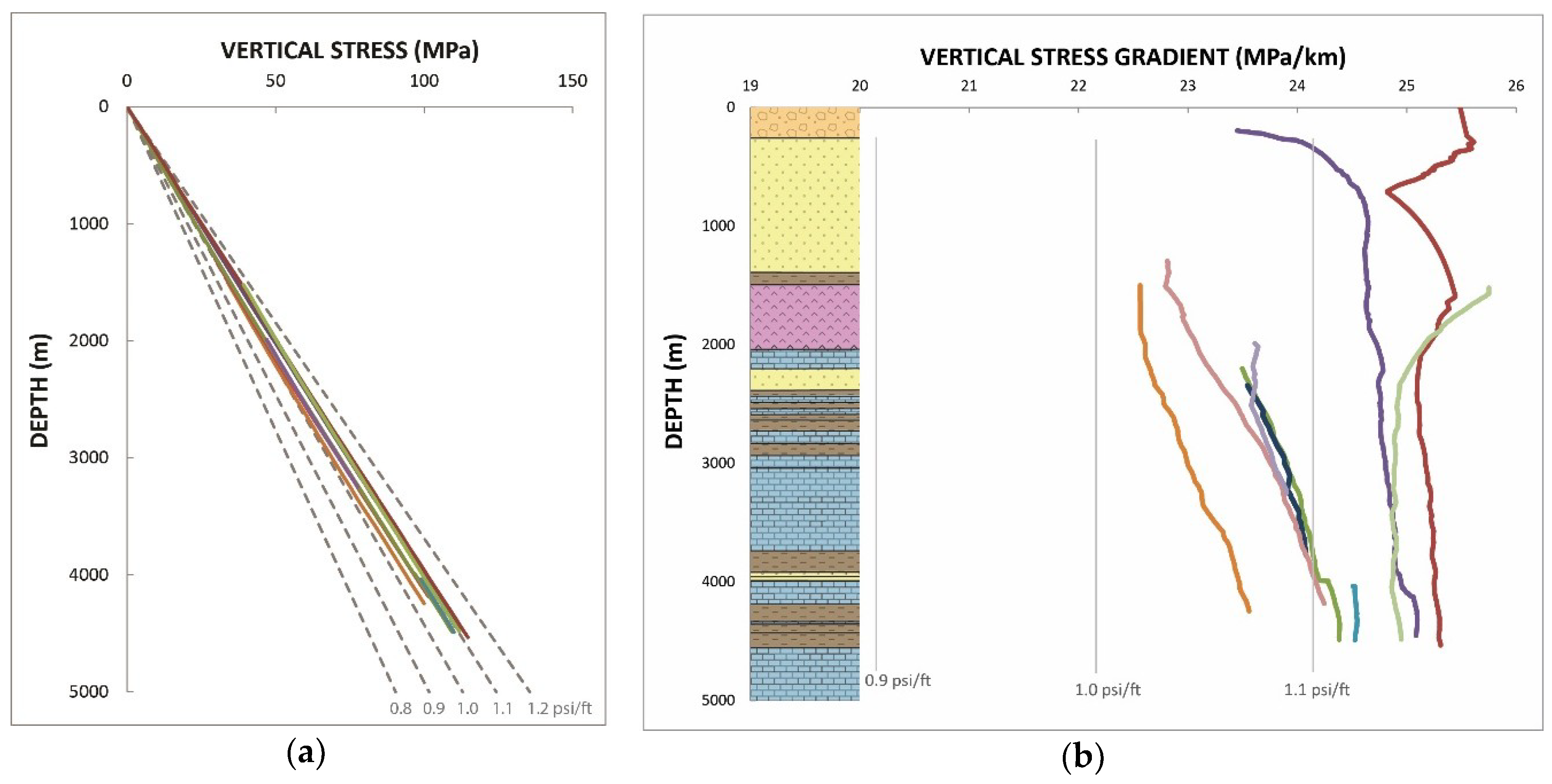
5. Overburden in the Abadan Plain Basin

Vertical stress of some wells of this basin were examined that vary between 22.5 MPa/km (~1 psi/ft) at the southernmost part of the study area and 25.5 MPa/Km (~1.13 psi/ft) in the middle of the basin (Figure 6). Similar ranges of overburden to the Abadan Plain Basin have been observed in sedimentary basins of SE Asia such as Brunei [61,62]. In the Abadan Plain Basin, the difference between vertical stresses is greater at shallower depths and remarkably less at deeper parts of the wells. A south to north decreasing trend of σv is observed in this basin which suggests the role of the Zagros Deformation on the magnitude of vertical stress. Such trend suggests the effect of the Zagros Orogeny (binding northern border of the basin) on the vertical stress. In this region, Eurasia-Arabia plate collision has resulted in thrust tectonics, associated with shortening and thickening of the strata along the direction of collision. The formations of the northern fields under the influence of the Zagros Orogeny are more folded than the southern parts of the basin, and hence are characterised with extensive fractures. In the light of a relatively narrow range of σv variation in this basin, compaction of deposits is identified as the primary cause of the variation in the sediment densities and associated differences in the vertical stress. Tectonic forces and the structure of the anticlines are secondary phenomena affecting the formation densities.

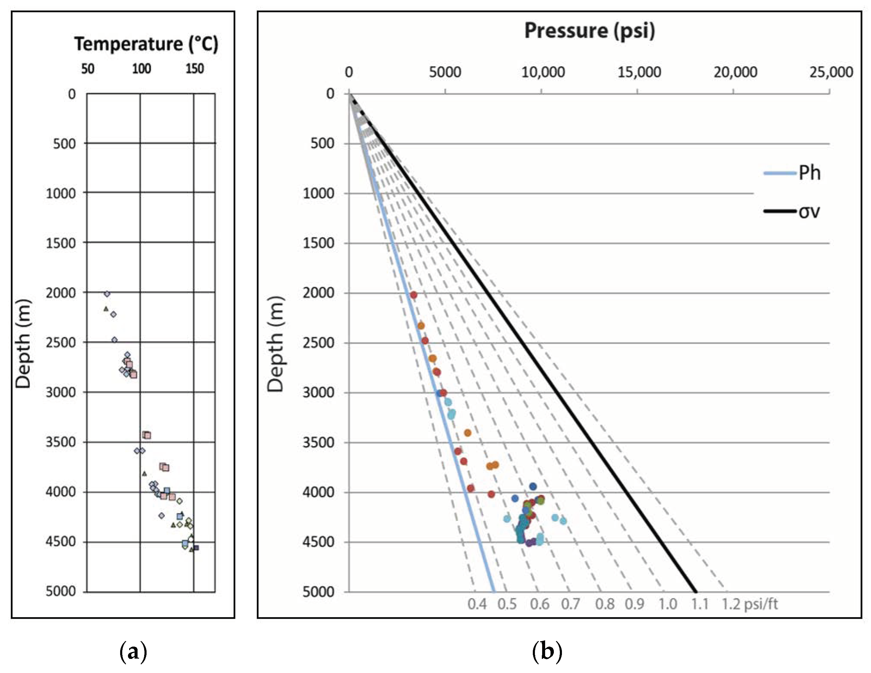
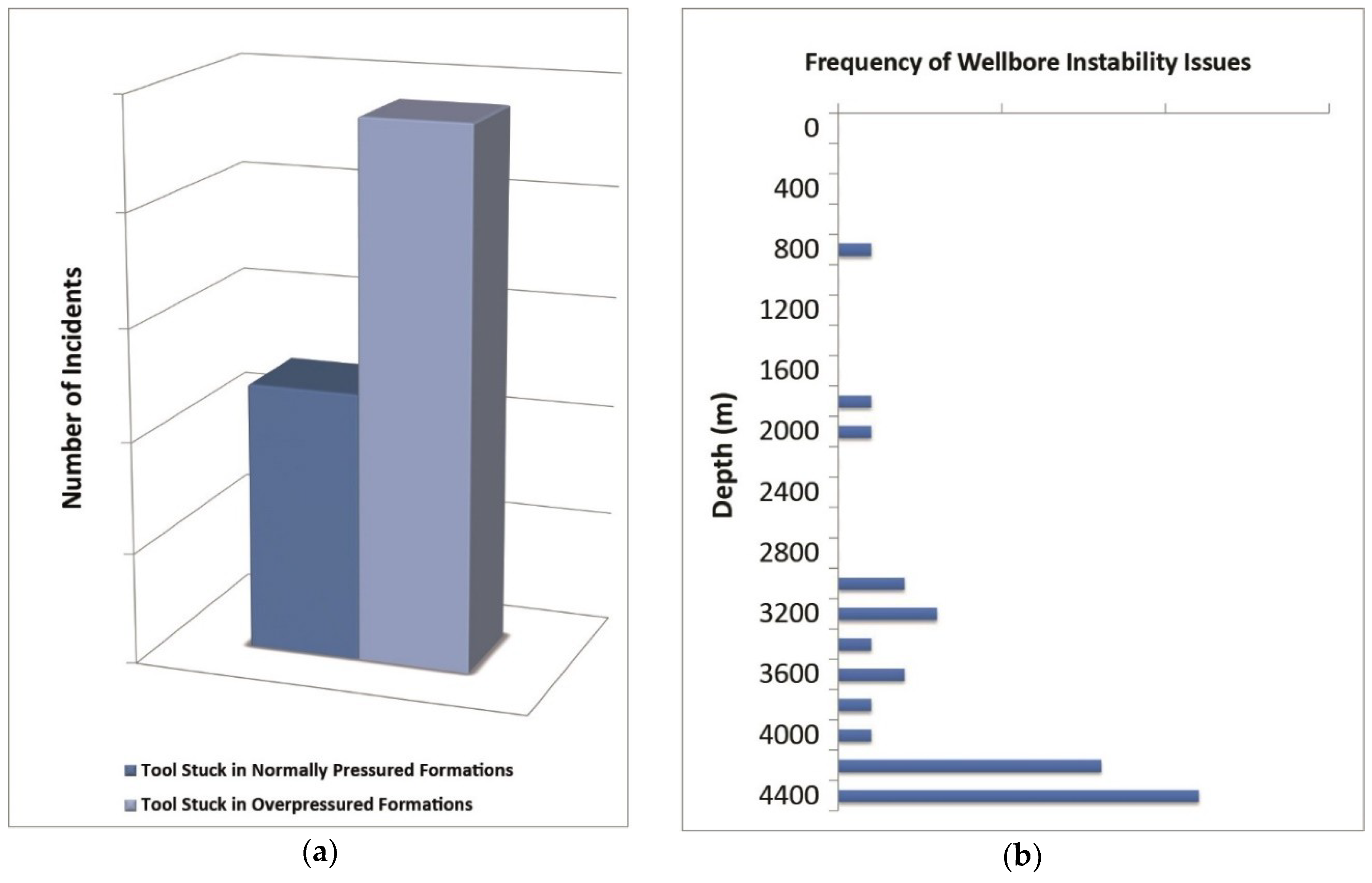
6. Pore Pressure in the Abadan Plain Basin

The majority of shallow formations in the Abadan Plain Basin are in a good hydrodynamic link to the surface and thus are normally pressured. According to the fluid density and salinity, the hydrostatic pore pressure gradient is 10 MPa/km (0.465 psi/ft) in this region, and any values more than that a considered as overpressure. Among the Cretaceous to present day deposits, two horizons are identified with abnormally high pore pressure in this basin and are explained below.
The formation top of the shallower overpressured horizon (the Gachsaran Formation) varies from around 1000 m at the southern end of the basin where the formation is normally pressured to nearly 1500 m deep at its north where pore pressure goes beyond the hydrostatic gradient. The formation becomes deeper and thicker towards the north-east, as it approaches the ZFTB. Sequences at the north have undergone extensive foldings along the Zagros structure and become thicker as a result of planar shortening. Pore pressure in the Gachsaran Formation also follows a similar trend to the depth of burial and thickness. The formation is highly ovepressured in areas closer to the Zagros Front Fault, and is normally pressured at southern parts of the basin.
The deeper observed overpressured horizon forms the seal or cap rock to the underlying Fahliyan Formation that is occasionally hydrocarbon bearing. Both of these formations exhibit significant degrees of overpressure. The Gadvan Formation, while becoming thicker, gets deeper to the north-east. Similar to the Gachsaran Formation, thickening behaviour of the Gadvan shale is interpreted as a result of crustal deformation at the vicinity of the Zagros Structure. However, unlike the Gachsaran, the Gadvan and Fahliyan formations are consistently overpressured across the basin. Similarly, there is a zone of anomaly in the temperature gradient at the depth of the Gadvan and Fahliyan formations which agrees with the pressure regime as a result of a sealing condition (Figure 7). The Gadvan and Fahliyan formations exhibited different degrees of overpressure. The pore pressure tends to decrease at the bottom of the Fahliyan Formation, which creates additional complexity to the hydrology of the basin [30]. Similar to some other areas of the Zagros Structure [63], overpressure is often encountered in carbonate formations where none of the standard porosity responses to overpressure are observed, and thus, pore pressure is hard to predict. Among several mechanisms identified as the origin of overpressures in this area, disequilibrium compaction is the dominant mechanism while clay dehydration within the deeper source rocks could have triggered the overpressuring and later been transferred to the overlying reservoir rocks [30].
An overview of reported stuck tool incidents from some wells, as a proxy indicator of wellbore instability issues, highlights some of the difficulties in drilling and completing wells in the Abadan Plain Basin (Figure 8a). The observed events are categorised into being either in normally pressured or overpressured sequences. Tool stuck issues happen in shallow formations, but most issues occur in the Lower Cretaceous and older deposits (Figure 8b). Formations are significantly shalier at depths between 3200 to 4000 m, and hence the observed wellbore instability in these deeper zones may be related to weaker mechanical strengths in these shale deposits or to the presence of swelling shales. However, tool stuck incidents at 4000 m depth and beyond are in the carbonate rocks, and seem to be a result of high pore pressure which reduces the effective stress and drilling mud overbalance. Nevertheless, wellbore instability was most common in the sequences equivalent to the Gadvan and Fahliyan formations. In the light of the frequency of wellbore stability issues (Figure 8b), major concerns for the overpressured formations are also highlighted and provide a useful clue for the casing and completion design of future wells. This should be noted in any attempt in deeper drilling operations, hydraulic fracturing or any other enhanced oil recovery (EOR) plans.

7. Summary of Hydrocarbon Geochemistry

Most of the hydrocarbon in the Abadan Plain Basin have accumulated in the reservoir rocks further a lateral migration from underlying source rocks. According to Pitman, et al. [64], oil accumulations in the source rocks have been generated in the Late Cretaceous with its peak expulsion in the Late Miocene and Pliocene eras as a result of depocenter expansion of such intrashelf basins along the Zagros foredeep trend. Vertical migration has been identified as the dominant pathway of hydrocarbon charging from source rocks in local intrashelf basins during the Late Cretaceous through the middle Miocene era, whereas other fields could have charged when compression-related traps were being formed [64]. The main reservoirs in this basin are the Fahliyan, Khalij and Zubeir members of the Gadvan Formation and Sandstone members of the Kazhdumi Formation (Burgan Sand), Sarvak, Ilam, and Asmari formations. Cap rocks mostly consisted of overlain argillaceous beds, with an exception of the evaporitic Gachsaran Formation that is a cap rock of the Asmari reservoir.
Analyzing oil samples from different reservoirs of the Abadan Plain Basin by Alizadeh, et al. [23] reveals that low concentrations of normal alkane (ranging 6–18) contribute to the relatively high values of C17/C27 (ranging 3.8–6.21), suggesting that hydrocarbons were derived from marine organic matter [65,66]. Chemical attributes of the oil samples also indicate the conditions in which the sediments were deposited. The Carbon Preference Index (CPI) ranges between 0.94 and 0.99, which indicates a carbonate depositional environment according to Moldowan, et al. [67]. CPI values combined with relatively low magnitudes of Pristane/Phytane (Pr/Ph ranging 0.36–0.5) indicate an anoxic paleo-environment [68]. Furthermore, a higher presence of C29 steranes in the samples (39.1–42.2) can be an indication of an organic-rich depositional environment [69]. However, the origin of dibenzothiophene is a sign of the interaction of hydrogen sulphide or polysultides with an organic substrate [70], and therefore, dibenzothiophene/phenanthrene versus Pr/Ph suggests a sulfur-rich marine and lacustrine depositional environment. Concurrently, high abundance of C21 and C22 pregnanes is a key indicator of a hypersaline depositional environment, and further indicates that the oil formed in association with carbonate rocks [71,72]. Alizadeh, et al. [23] showed that the presence of C21 and C22 pregnanes is predominantly controlled by environmental and source factors such as lithology, marine organic matter and salinity. Therefore, identified the depositional environment of the oil source in the Abadan Plain Basin as an anoxic marine carbonate environment with free H2S.
In the Abadan Plain Basin, the Pabdeh Formation charges the Asmari reservoir, the Kazhdumi Formation charges the Sarvak reservoir, and the Garau Formation charges the Fahliyan reservoir. The Gadvan formation is an exception, as it has both reservoir and seal attributes (is a reservoir in some areas and acts as the cap rock in the other regions) which marks the uppermost boundary of overpressures. It is mainly a seal formation, but in some areas has a producible accumulation of hydrocarbon, which is capped by shale layers at the top of the formation. Similarly, the Kazhdumi Formation has been identified with both source and reservoir rock properties in nearby areas, but is mainly reported as a source rock in this basin. Pabdeh, Kazhdumi and Gadvan source rocks are in the oil expulsion phase, and the Garau Formation source rock is currently at the beginning of gas expulsion [18]. According to the oil samples tested by Alizadeh, et al. [23], the Lower Cretaceous (Kazhdumi, Gadvan and Fahliyan) reservoirs have higher thermal maturity (higher API and lower concentration of aromatics) than shallower reservoirs. Hence, it is expected that while the formations become tighter (low porosity and permeability) with increasing depth, deeper explorations would be expected to encounter natural gas or light oil hydrocarbons. In the very first attempt of deeper exploration, hydrocarbon was traced in the Fahliyan Formation. However, due to low permeability, which resulted in low rates of fluid extraction and difficulties to complete the well at depths beyond 4000 m, this formation was considered a non-economic horizon in some areas. Recently, with further geochemical and basin analysis, the potential of the Garau source rock and its possible pathway to charge the Fahliyan Formation have been proven [18], and subsequently operators have become interested in exploration and production from this formation and its prospects beneath.
There is another prospect beyond the depth interval of this research that includes Carboniferous/Permian source rocks, and accumulations in the Dehram Formation (Permian period), with the source rock possibly at the gas expulsion phase; hence, it is an interesting subject for further explorations. Similarly, the hydrocarbon expulsion capability of the Silurian shales has been identified [73,74,75,76,77,78], and therefore, the Devonian sandstone may also be considered as a potential reservoir rock [23,76,79] and could be a possible target for further explorations.

8. Conclusions

The Abadan Plain Basin is a foredeep basin to the southwest of the Zagros Fold-Thrust-Belt, bounded along its northern and eastern margin by the Dezful Embayment (and further to the Zagros Deformation Front), which extends into Iraq at its northern end, and into the Persian Gulf to the south. Appropriate geometric and timing arrangements of the source rock, reservoir and sealing cap rock, along with a proper deposition in an organic-reach marine environment since the Jurassic, have resulted in the provision of remarkable accumulations of hydrocarbon in this region. Although the geological structures of this basin are oriented similar to the structures of the Arabian Plate, some of their attributes are similar to those of the Dezful Embayment and Zagros Fold-Thrust-Belt; thus this basin seems to be a transition zone between two major structural settings. Geological structures are also significantly affected by the Arabia-Eurasia plate collision and along with continuous deposition in a marine environment, lack of post-collision metamorphic or intense tectonic activities, and adequate placement of source and cap rocks, created ideal conditions for hydrocarbon accumulation. Furthermore, the existence of likely significant deeper source rock and permeable formations suggests a high likelihood of exploration success in formations deeper than those currently targeted for production. However, further explorations in this basin encounter a major challenge of several overpressured sequences in the carbonate formations, which represent a significant drilling safety hazard, as well as being associated with expensive non-productive time due to wellbore instability issues. Overpressures in this basin are mainly generated by disequilibrium compaction that is developed by clay dehydration and lateral transfer from deeper source rocks.

Author Contributions

V.A. wrote the manuscript with support from M.T. and K.A. who supervised the project. M.T. provided general frame of the study and both M.T. and K.A. reviewed and commented on the manuscript.

Funding

This research received no external funding.

Conflicts of Interest

The authors declare no conflict of interest.

References

  1. McQuillan, H. Proceeding of the Second Conference on Petroleum Geochemistry and exploration in the Afro-Asian Region The role of basement tectonics in the control of sedimentary facies, structural patterns and salt plug emplacements in the Zagros fold belt of southwest Iran. J. Southeast Asian Earth Sci. 1991, 5, 453–463. [Google Scholar] [CrossRef]
  2. Bordenave, M.; Hegre, J. Current distribution of oil and gas fields in the Zagros Fold Belt of Iran and contiguous offshore as the result of the petroleum systems. Geol. Soc. Lond. Spec. Publ. 2010, 330, 291–353. [Google Scholar] [CrossRef]
  3. Alsharhan, A.S.; Nairn, A.E.M. Chapter 12–The hydrocarbon habitat of the Zagros basin. In Sedimentary Basins and Petroleum Geology of the Middle East; Elsevier Science B.V.: Amsterdam, The Netherlands, 2003; pp. 651–736. [Google Scholar]
  4. Sepehr, M.; Cosgrove, J.W. Structural framework of the Zagros Fold–Thrust Belt, Iran. Mar. Pet. Geol. 2004, 21, 829–843. [Google Scholar] [CrossRef]
  5. Rafighdoust, Y.; Eckstein, Y.; Harami, R.M.; Gharaie, M.H.M.; Griffith, E.M.; Mahboubi, A. Isotopic analysis, hydrogeochemistry and geothermometry of Tang-Bijar oilfield springs, Zagros region, Iran. Geothermics 2015, 55, 24–30. [Google Scholar] [CrossRef]
  6. Najafi, M.; Yassaghi, A.; Bahroudi, A.; Vergés, J.; Sherkati, S. Impact of the Late Triassic Dashtak intermediate detachment horizon on anticline geometry in the Central Frontal Fars, SE Zagros fold belt, Iran. Mar. Pet. Geol. 2014, 54, 23–36. [Google Scholar] [CrossRef] [Green Version]
  7. Motamedi, H.; Sherkati, S.; Sepehr, M. Structural style variation and its impact on hydrocarbon traps in central Fars, southern Zagros folded belt, Iran. J. Struct. Geol. 2012, 37, 124–133. [Google Scholar] [CrossRef]
  8. Sfidari, E.; Zamanzadeh, S.M.; Dashti, A.; Opera, A.; Tavakkol, M.H. Comprehensive source rock evaluation of the Kazhdumi Formation, in the Iranian Zagros Foldbelt and adjacent offshore. Mar. Pet. Geol. 2016, 71, 26–40. [Google Scholar] [CrossRef]
  9. Abdollahie Fard, I.; Braathen, A.; Mokhtari, M.; Alavi, S.A. Interaction of the Zagros Fold–Thrust Belt and the Arabian-type, deep-seated folds in the Abadan Plain and the Dezful Embayment, SW Iran. Pet. Geosci. 2006, 12, 347–362. [Google Scholar] [CrossRef]
  10. Murris, R.J. Middle-East—Stratigraphic Evolution and Oil Habitat. AAPG Bull. 1980, 64, 597–618. [Google Scholar]
  11. Alavi, M. Regional Stratigraphy of the Zagros Fold-Thrust Belt of Iran and Its Proforeland Evolution. Am. J. Sci. 2004, 304, 1–20. [Google Scholar] [CrossRef]
  12. Ala, M.A.; Kinghorn, R.R.F.; Rahman, M. Organic Geochemistry and Source Rock Characteristics of The Zagros Petroleum Province, Southwest Iran. J. Pet. Geol. 1980, 3, 61–89. [Google Scholar] [CrossRef]
  13. Stoneley, R. The Middle East Basin: A summary overview. Geol. Soc. Lond. Spec. Publ. 1990, 50, 293–298. [Google Scholar] [CrossRef]
  14. Beydoun, Z.R.; Hughes Clarke, M.W.; Stoneley, R. Petroleum in the Zagros Basin: A Late Tertiary Foreland Basin Overprinted onto the Outer Edge of a Vast Hydrocarbon-Rich Paleozoic-Mesozoic Passive-Margin Shelf. In AAPG Memoir 55 Foreland Basins and Fold Belts; U.S. Department of Energy: Wastington, DC, USA, 1992; pp. 309–339. [Google Scholar]
  15. Owen, E.R. One Hundred Years of Middle Eastern Oil; Brandeis University, Crown Center for Middle East Studies: Waltham, MA, USA, 2008. [Google Scholar]
  16. Al Naqib, K.M. Geology of the Arabian Peninsula; southwestern Iraq. US Geol. Surv. Prof. Paper 1967, 560, 1–47. [Google Scholar]
  17. Arvandan Oil and Gas Co. Darquain Oil Field. Available online: http://aogc.ir/company/oilfields/82-darquin (accessed on 11 November 2014).
  18. Zeinalzadeh, A.; Moussavi-Harami, R.; Mahboubi, A.; Sajjadian, V.A. Basin and petroleum system modeling of the Cretaceous and Jurassic source rocks of the gas and oil reservoirs in Darquain field, south west Iran. J. Nat. Gas Sci. Eng. 2015, 26, 419–426. [Google Scholar] [CrossRef]
  19. Alavi, M. Structures of the Zagros fold-thrust belt in Iran. Am. J. Sci. 2007, 307, 1064–1095. [Google Scholar] [CrossRef]
  20. Saura, E.; Garcia-Castellanos, D.; Casciello, E.; Parravano, V.; Urruela, A.; Vergés, J. Modeling the flexural evolution of the Amiran and Mesopotamian foreland basins of NW Zagros (Iran-Iraq). Tectonics 2015, 34, 377–395. [Google Scholar] [CrossRef] [Green Version]
  21. Agard, P.; Omrani, J.; Jolivet, L.; Whitechurch, H.; Vrielynck, B.; Spakman, W.; Monie, P.; Meyer, B.; Wortel, R. Zagros orogeny: A subduction-dominated process. Geol. Mag. 2011, 148, 692–725. [Google Scholar] [CrossRef]
  22. Moallemi, S.A.; Kermanshah, M. Significances of integrated study of Abadan Plain depositional basin. Explor. Prod. 2012, 94, 20–22. [Google Scholar]
  23. Alizadeh, B.; Saadati, H.; Rashidi, M.; Kobraei, M. Geochemical investigation of oils from Cretaceous to Eocene Sedimentary sequences of the Abadan Plain, Southwest Iran. Mar. Pet. Geol. 2015. [Google Scholar] [CrossRef]
  24. ARAMCO. Oil and the Middle East; Arabian American Oil Company: Dhahran, Saudi Arabia, 1968. [Google Scholar]
  25. British Petroleum. Statistical Review of World Energy 2014; British Petroleum: London, UK, 2014. [Google Scholar]
  26. Ghorbani, M. An Introduction to the Economic Geology of Iran; Geological survey and mineral explorations of Iran: Tehran, Iran, 2002. [Google Scholar]
  27. Falcon, N.L. Southern Iran: Zagros Mountains. Geol. Soc. Lond. Spec. Publ. 1974, 4, 199–211. [Google Scholar] [CrossRef]
  28. Motiei, H. Geology of Iran; Geological Survey of Iran: Tehran, Iran, 1995. (In Persian) [Google Scholar]
  29. Haghi Pour, A.; Aghanabati, A. Geological Map of Iran; Geological Survey of Iran: Tehran, Iran, 1988. [Google Scholar]
  30. Soleimani, B.; Hassani-Giv, M.; Abdollahi fard, I. Formation Pore Pressure Variation of the Neocomian Sedimentary Succession (the Fahliyan Formation) in the Abadan Plain Basin, SW of Iran. Geofluids 2017, 2017. [Google Scholar] [CrossRef]
  31. Motiei, H. Petroleum Geology of Zagros; Geological Survey of Iran: Tehran, Iran, 1993. (In Persian) [Google Scholar]
  32. Blanc, E.J.P.; Allen, M.B.; Inger, S.; Hassani, H. Structural styles in the Zagros Simple Folded Zone, Iran. J. Geol. Soc. 2003, 160, 401–412. [Google Scholar] [CrossRef]
  33. Hessami, K.; Koyi, H.A.; Talbot, C.J.; Tabasi, H.; Shabanian, E. Progressive unconformities within an evolving foreland fold-thrust belt, Zagros Mountains. J. Geol. Soc. 2001, 158, 969–981. [Google Scholar] [CrossRef]
  34. McQuarrie, N. Crustal scale geometry of the Zagros fold–thrust belt, Iran. J. Struct. Geol. 2004, 26, 519–535. [Google Scholar] [CrossRef]
  35. Rajabi, M.; Sherkati, S.; Bohloli, B.; Tingay, M. Subsurface fracture analysis and determination of in-situ stress direction using FMI logs: An example from the Santonian carbonates (Ilam Formation) in the Abadan Plain, Iran. Tectonophysics 2010, 492, 192–200. [Google Scholar] [CrossRef]
  36. Al-Husseini, M.I. Origin of the Arabian Plate structures: Amar collision and Najd rift. GEOARABIA-MANAMA- 2000, 5, 527–542. [Google Scholar]
  37. Selley, R.C.; Sonnenberg, S.A. Elements of Petroleum Geology; Academic Press: Cambridge, MA, USA, 2014. [Google Scholar]
  38. Takin, M. Iranian Geology and Continental Drift in the Middle East. Nature 1972, 235, 147–150. [Google Scholar] [CrossRef]
  39. Berberian, M.; King, G.C.P. Towards a Paleogeography and Tectonic Evolution of Iran. Can. J. Earth Sci. 1981, 18, 210–265. [Google Scholar] [CrossRef]
  40. Sarkarinejad, K.; Azizi, A. Slip partitioning and inclined dextral transpression along the Zagros Thrust System, Iran. J. Struct. Geol. 2008, 30, 116–136. [Google Scholar] [CrossRef]
  41. Saadatinejad, M.R.; Sarkarinejad, K. Application of the spectral decomposition technique for characterizing reservoir extensional system in the Abadan Plain, southwestern Iran. Mar. Pet. Geol. 2011, 28, 1205–1217. [Google Scholar] [CrossRef]
  42. Molinaro, M.; Guezou, J.C.; Leturmy, P.; Eshraghi, S.A.; de Lamotte, D.F. The origin of changes in structural style across the Bandar Abbas syntaxis, SE Zagros (Iran). Mar. Pet. Geol. 2004, 21, 735–752. [Google Scholar] [CrossRef]
  43. Hafkenscheid, E.; Wortel, M.; Spakman, W. Subduction history of the Tethyan region derived from seismic tomography and tectonic reconstructions. J. Geophys. Res. Solid Earth 2006, 111. [Google Scholar] [CrossRef] [Green Version]
  44. Alavi, M. Tectonics of the Zagros Orogenic Belt of Iran—New Data and Interpretations. Tectonophysics 1994, 229, 211–238. [Google Scholar] [CrossRef]
  45. Yilmaz, Y. New Evidence and Model on the Evolution of the Southeast Anatolian Orogen. Geol. Soc. Am. Bull. 1993, 105, 251–271. [Google Scholar] [CrossRef]
  46. Allen, M.; Jackson, J.; Walker, R. Late Cenozoic reorganization of the Arabia-Eurasia collision and the comparison of short-term and long-term deformation rates. Tectonics 2004, 23, TC2008. [Google Scholar] [CrossRef]
  47. Homke, S.; Vergés, J.; Serra-Kiel, J.; Bernaola, G.; Sharp, I.; Garcés, M.; Montero-Verdú, I.; Karpuz, R.; Goodarzi, M.H. Late Cretaceous–Paleocene formation of the proto–Zagros foreland basin, Lurestan Province, SW Iran. Geol. Soc. Am. Bull. 2009, 121, 963–978. [Google Scholar] [CrossRef]
  48. Mouthereau, F.; Lacombe, O.; Vergés, J. Building the Zagros collisional orogen: Timing, strain distribution and the dynamics of Arabia/Eurasia plate convergence. Tectonophysics 2012, 532–535, 27–60. [Google Scholar] [CrossRef]
  49. DeMets, C.; Gordon, R.G.; Argus, D.F.; Stein, S. Current Plate Motions. Geophys. J. Int. 1990, 101, 425–478. [Google Scholar] [CrossRef]
  50. DeMets, C.; Gordon, R.G.; Argus, D.F. Geologically current plate motions. Geophys. J. Int. 2010, 181, 1–80. [Google Scholar] [CrossRef] [Green Version]
  51. McClusky, S.; Balassanian, S.; Barka, A.; Demir, C.; Ergintav, S.; Georgiev, I.; Gurkan, O.; Hamburger, M.; Hurst, K.; Kahle, H.; et al. Global Positioning System constraints on plate kinematics and dynamics in the eastern Mediterranean and Caucasus. J. Geophys. Res. Solid Earth 2000, 105, 5695–5719. [Google Scholar] [CrossRef]
  52. Nilforoushan, F.; Masson, F.; Vernant, P.; Vigny, C.; Martinod, J.; Abbassi, M.; Nankali, H.; Hatzfeld, D.; Bayer, R.; Tavakoli, F.; et al. GPS network monitors the Arabia-Eurasia collision deformation in Iran. J. Geod. 2003, 77, 411–422. [Google Scholar] [CrossRef]
  53. Vernant, P.; Nilforoushan, F.; Hatzfeld, D.; Abbassi, M.R.; Vigny, C.; Masson, F.; Nankali, H.; Martinod, J.; Ashtiani, A.; Bayer, R.; et al. Present-day crustal deformation and plate kinematics in the Middle East constrained by GPS measurements in Iran and northern Oman. Geophys. J. Int. 2004, 157, 381–398. [Google Scholar] [CrossRef] [Green Version]
  54. Mouthereau, F.; Lacombe, O.; Tensi, J.; Bellahsen, N.; Kargar, S.; Amrouch, K. Mechanical Constraints on the Development of the Zagros Folded Belt (Fars). In Thrust Belts and Foreland Basins; Lacombe, O., Roure, F., Lavé, J., Vergés, J., Eds.; Springer: Berlin/Heidelberg, Germany, 2007; pp. 247–266. [Google Scholar]
  55. Lacombe, O.; Amrouch, K.; Mouthereau, F.; Dissez, L. Calcite twinning constraints on late Neogene stress patterns and deformation mechanisms in the active Zagros collision belt. Geology 2007, 35, 263–266. [Google Scholar] [CrossRef]
  56. Aubourg, C.; Smith, B.; Eshraghi, A.; Lacombe, O.; Authemayou, C.; Amrouch, K.; Bellier, O.; Mouthereau, F. New magnetic fabric data and their comparison with palaeostress markers in the Western Fars Arc (Zagros, Iran): tectonic implications. Geol. Soc. Lond. Spec. Publ. 2010, 330, 97–120. [Google Scholar] [CrossRef]
  57. Dewey, J.F.; Helman, M.L.; Knott, S.D.; Turco, E.; Hutton, D.H.W. Kinematics of the western Mediterranean. Geol. Soc. Lond. Spec. Publ. 1989, 45, 265–283. [Google Scholar] [CrossRef]
  58. Sattarzadeh, Y.; Cosgrove, J.W.; Vita-Finzi, C. The interplay of faulting and folding during the evolution of the Zagros deformation belt. Geol. Soc. Lond. Spec. Publ. 1999, 169, 187–196. [Google Scholar] [CrossRef]
  59. Johnson, P.R.; Stewart, I.C.F. Magnetically Inferred Basement Structure in Central Saudi-Arabia. Tectonophysics 1995, 245, 37–52. [Google Scholar] [CrossRef]
  60. International Seismological Centre. Event Catalogue; Internatl. Seis. Cent.: Thatcham, UK, 2016. [Google Scholar]
  61. Tingay, M.R.P. Situ Stress and Overpressures of Brunei Darussalam; The University of Adelaide: Adelaide, Australia, 2003. [Google Scholar]
  62. Tingay, M.R.P.; Hillis, R.R.; Morley, C.K.; Swarbrick, R.E.; Okpere, E.C. Variation in vertical stress in the Baram Basin, Brunei: Tectonic and geomechanical implications. Mar. Pet. Geol. 2003, 20, 1201–1212. [Google Scholar] [CrossRef]
  63. Atashbari, V.; Tingay, M.R. Pore Pressure Prediction in Carbonate Reservoirs. In Proceedings of the SPE Latin America and Caribbean Petroleum Engineering Conference, Mexico City, Mexico, 16–18 April 2012. [Google Scholar]
  64. Pitman, J.K.; Steinshouer, D.; Lewan, M. Petroleum generation and migration in the Mesopotamian Basin and Zagros Fold Belt of Iraq: Results from a basin-modeling study. GeoArabia 2004, 9, 41–72. [Google Scholar]
  65. Peter, K.; Moldowan, J. The Biomarker Guide: Interpreting Molecular Fossils in Petroleum and Ancient Sediments; Prentice Hall: Englewood Cliffs, NJ, USA, 1993. [Google Scholar]
  66. Powell, T.; Boreham, C. Terrestrially sourced oils: Where do they exist and what are our limits of knowledge?—A geochemical perspective. Geol. Soc. Lond. Spec. Publ. 1994, 77, 11–29. [Google Scholar] [CrossRef]
  67. Moldowan, J.M.; Seifert, W.K.; Gallegos, E.J. Relationship between petroleum composition and depositional environment of petroleum source rocks. AAPG Bull. 1985, 69, 1255–1268. [Google Scholar]
  68. Connan, J.; Bouroullec, J.; Dessort, D.; Albrecht, P. The microbial input in carbonate-anhydrite facies of a sabkha palaeoenvironment from Guatemala: A molecular approach. Org. Geochem. 1986, 10, 29–50. [Google Scholar] [CrossRef]
  69. Volkman, J.K. A review of sterol markers for marine and terrigenous organic matter. Org. Geochem. 1986, 9, 83–99. [Google Scholar] [CrossRef]
  70. Hughes, W.B.; Holba, A.G.; Dzou, L.I. The ratios of dibenzothiophene to phenanthrene and pristane to phytane as indicators of depositional environment and lithology of petroleum source rocks. Geochim. Cosmochim. Acta 1995, 59, 3581–3598. [Google Scholar] [CrossRef]
  71. Mello, M.; Gaglianone, P.; Brassell, S.; Maxwell, J. Geochemical and biological marker assessment of depositional environments using Brazilian offshore oils. Mar. Pet. Geol. 1988, 5, 205–223. [Google Scholar] [CrossRef]
  72. Requejo, A.; Hieshima, G.; Hsu, C.; McDonald, T.; Sassen, R. Short-chain (C 21 and C 22) diasteranes in petroleum and source rocks as indicators of maturity and depositional environment. Geochim. Cosmochim. Acta 1997, 61, 2653–2667. [Google Scholar] [CrossRef]
  73. Mobasheri, A. Sedimentological studies on the Seyahou and Sarchahan formations in Tang-e-Zakeen of Kuh-e-Faraghan at Bardar Abbas area, southern Iran. Nat. Iran. Oil Co. 2005, 7, 1–56. [Google Scholar]
  74. Jones, P.J.; Stump, T.E. Depositional and tectonic setting of the Lower Silurian hydrocarbon source rock facies, central Saudi Arabia. AAPG Bull. 1999, 83, 314–332. [Google Scholar]
  75. Ghavidel-syooki, M.; Álvaro, J.J.; Popov, L.; Pour, M.G.; Ehsani, M.H.; Suyarkova, A. Stratigraphic evidence for the Hirnantian (latest Ordovician) glaciation in the Zagros Mountains, Iran. Palaeogeogr. Palaeoclimatol. Palaeoecol. 2011, 307, 1–16. [Google Scholar] [CrossRef]
  76. Zoleikhaei, Y.; Amini, A.; Zamanzadeh, S.M. Integrated provenance analysis of Zakeen (Devonian) and Faraghan (early Permian) sandstones in the Zagros belt, SW Iran. J. Afr. Earth Sci. 2015, 101, 148–161. [Google Scholar] [CrossRef]
  77. Bagheri, R.; Nadri, A.; Raeisi, E.; Eggenkamp, H.G.M.; Kazemi, G.A.; Montaseri, A. Hydrochemical and isotopic (δ18O, δ2H, 87Sr/86Sr, δ37Cl and δ81Br) evidence for the origin of saline formation water in a gas reservoir. Chem. Geol. 2014, 384, 62–75. [Google Scholar] [CrossRef]
  78. Saberi, M.H.; Rabbani, A.R. Origin of natural gases in the Permo-Triassic reservoirs of the Coastal Fars and Iranian sector of the Persian Gulf. J. Nat. Gas Sci. Eng. 2015, 26, 558–569. [Google Scholar] [CrossRef]
  79. Al-Ghazi, A. New evidence for the Early Devonian age of the Jauf Formation in northern Saudi Arabia. Rev. Micropaléontol. 2007, 50, 59–72. [Google Scholar] [CrossRef]
Figure 1. Abadan Plain Basin and oil and gas fields in the region. Abadan Plain Basin is the area within the dashed red polygon.
Geosciences 08 00496 g001
Figure 2. (a) Simplified geologic map of the Arabian Plate and Zagros Fold-Thrust-Belt based on Reference [24]. Tectonic features are from Reference [19]. Abbreviations: DE: Dezful Embayment (the region between the Abadan Plain Basin and MFF), MFF: Mountain Front Flexure, MZT: Main Zagros Thrust, ZTZ: Zagros Thrust Zone, ZDF: Zagros Deformation Front, ZS: Zagros structure. Abadan Plain Basin is bounded by the Zagros front fault to the north and north-east. The location of section A–A’ is also indicated. (b) Simplified cross-section across the Arabian Shield, Arabian Platform and the ZFTB along line A–A’ modified from Reference [9].
Geosciences 08 00496 g002
Figure 3. Stratigraphy of the Abadan Plain Basin. Observed formation thicknesses are also reported. Lithology column and Thicknesses marked by asterisk are from Reference [9].
Geosciences 08 00496 g003
Figure 4. Schematic cross sections illustrating pre-obductional and obductional-initial collisional steps in the evolution of the Zagros collision zone, modified from Reference [44].
Geosciences 08 00496 g004
Figure 5. Seismic event map of the Zagros Fold-Thrust-Belt and northern Arabia from 1 January 1900 to 31 December 2016 from Reference [60]. Tectonic structures are from Reference [19]. The intensity of seismic events in the Abadan Plain Basin is lower than those of in the Zagros area.
Geosciences 08 00496 g005
Figure 6. (a) Calculated vertical stress (σv) magnitudes over the Abadan Plain Basin. (b) Calculated σv gradients of the Abadan Plain Basin. Vertical stress varies with depth and spatially between fields. Lithology column is from Reference [9].
Geosciences 08 00496 g006
Figure 7. (a) Temperature gradient in some of the wells of the Abadan Plain Basin. The temperature gradient reaches its peak at the depth of the Gadvan Shale. (b) Direct pressure measurements in the Abadan Plain Basin, color-coded by wells.
Geosciences 08 00496 g007
Figure 8. (a) Statistics of stuck tool (pipe, logging tools and bottom hole assemblies) events in some of the wells of the Abadan Plain Basin. (b) Frequency of wellbore instability issues in the Abadan Plain Basin. The majority of incidents occurred in the overpressured formations.
Geosciences 08 00496 g008

