Residents’ Perception and Assessment of Geomorphosites of the Alvão—Chaves Region


1
Department of Geography of Coimbra University, Faculty of Arts, Coimbra University, Portugal; Centre of Studies on Geography and Spatial Planning (CEGOT), RISCOS, 3004-530 Coimbra, Portugal
2
Centre of Studies on Geography and Spatial Planning (CEGOT), Coimbra, Oporto and Minho University, 3004-530 Coimbra, Portugal
*
Author to whom correspondence should be addressed.
Geosciences 2018, 8(10), 381; https://doi.org/10.3390/geosciences8100381
Submission received: 31 May 2018
/
Revised: 8 October 2018
/
Accepted: 15 October 2018
/
Published: 18 October 2018
(This article belongs to the Special Issue Geotourism)
Abstract
:This work focuses on the paradigms of a multidimensional and interdisciplinary evaluation of geomorphological heritage and its valorisation within a geosystemic reading of relations between a geomorphological and cultural landscape. This research aims to (i) select geomorphosites at different scales, which represent the regional geodiversity, according to an interdisciplinary approach; and (ii) better understand the perception of the local population concerning the different values of geomorphosites by applying a questionnaire that addresses the scientific, preservation, use, cultural, and educational dimensions. First, the authors selected the geomorphosites at a regional level by respecting the following criteria: (i) representativeness of the landform as a morphogenetic process; (ii) the witnessed periods of morpho-dynamics with potential to contribute to the reconstruction of paleoenvironmental conditions; (iii) the current morpho-dynamic nature; (iv) the importance to the shaping of the cultural landscape; and (v) the use value. Results showed that the major landforms are perceived as those with greater value by the local populations.
1. Introduction
The different definitions of geomorphological heritage reflect distinct valuation criteria [1], which stem from the theoretical and methodological framework of each scientific domain and the specific objectives of each research study [2]. The narrower or wider meanings of the geomorphological heritage prove to be equally useful and necessary by serving different application purposes [3]. Besides the geographical characteristics, the value of a geomorphosite also depends on its role in supporting a given ecosystem as well as its interrelation with other heritage typologies and its potential for research or education [4,5,6]. Inventory and evaluation processes of geomorphosites’ value should not focus only on landforms’ intrinsic properties. It is important to remark that an assessment of geomorphosites also serves the purpose of grounding the definition of protection levels, conducting educational and recreational activities, and reflecting its potential to generate economic activities [6]. Consequently, the inventory and evaluation of geomorphosites should also include its use value and its vulnerability to potential threats in order to sustain the drawing of guidelines for its use and the definition of protective measures. Considering the multiple purposes of the inventory and evaluation of geomorphosites, the scientific criteria of geophysical nature are insufficient since it is also essential to take into account the relationship between geomorphological heritage, local communities, and their “users/consumers” [7].
On the other hand, recent studies highlight the importance of positive perceptions of local inhabitants regarding the value of geomorphosites, influencing their involvement and commitment in the preservation and valuation of geoheritage within the scope of environmental conservation and geotourism [8,9] Achieving the support from local inhabitants through the respect of their cultural connections and economic interests plays a significant role in the sustainable utilization of geoheritage resources. As stated by Popa, et al., (2017) [10]: “Since a geosite is a local asset, the desire to conserve and use the site should be anchored with the local community“.
In economically and demographically depressed regions, geotourism may promote new forms of income generation to local inhabitants, creating direct and indirect job opportunities [11,12].
Therefore, the selection, assessment and management of geomorphosites need to take into account not only the scientific perspective, but also the expectations of the local community. If the promotion of geoheritage does not have a positive impact on local social and economic dynamics or if it does not reinforce local pride or the feeling of belonging the local community will probably neglect it, no matter how scientifically important it is [10].
Since the 90’s, several methodologies for the selection and assessment of geological and geomorphological heritage were developed, combining a wide range of quantitative and qualitative criteria, and tested in areas of high geodiversity [13]. These research works resulted in a growing number of geosite inventories and rankings. Nevertheless, studies addressing the relation of local communities with geoheritage are missing. Indeed, perception of local inhabitants concerning the value of geosites is poorly studied [14].
In this framework, the authors considered it relevant to the select the potential geomorphosites taking into account not only scientific criteria, i.e., the relevance of the geomorphosite to geology and geomorphology, but also other factors such as the importance for the shaping of the cultural landscape and the present use value, that were included in the assessment methodology.
This work will focus on the paradigms of a multidimensional and interdisciplinary evaluation of geomorphological heritage and its valorisation within a geosystemic reading of relations between geomorphology and cultural landscape [15,16,17].
If the specific characteristics of a landform, its process of formation and its morphodynamics are key factors for the assessment of its scientific interest in the field of geosciences; the recognition of its heritage value is a separate issue, open to multiple readings and dependent on a specific historical and sociocultural context. It is the society, through the agents and institutions that represent it, which is responsible for defining those tangible and intangible assets that have significant heritage value while identity reference for the preservation of its collective memory [18,19].
This research aims to (i) select geomorphosites at different scales, which represent the regional geodiversity, according to an interdisciplinary approach; and (ii) better understand the perception of the local population concerning the different values of geomorphosites by applying a questionnaire that addresses the scientific, preservation, current use, and cultural and educational dimensions.
2. Location and Geomorphological Framework of the Study Area
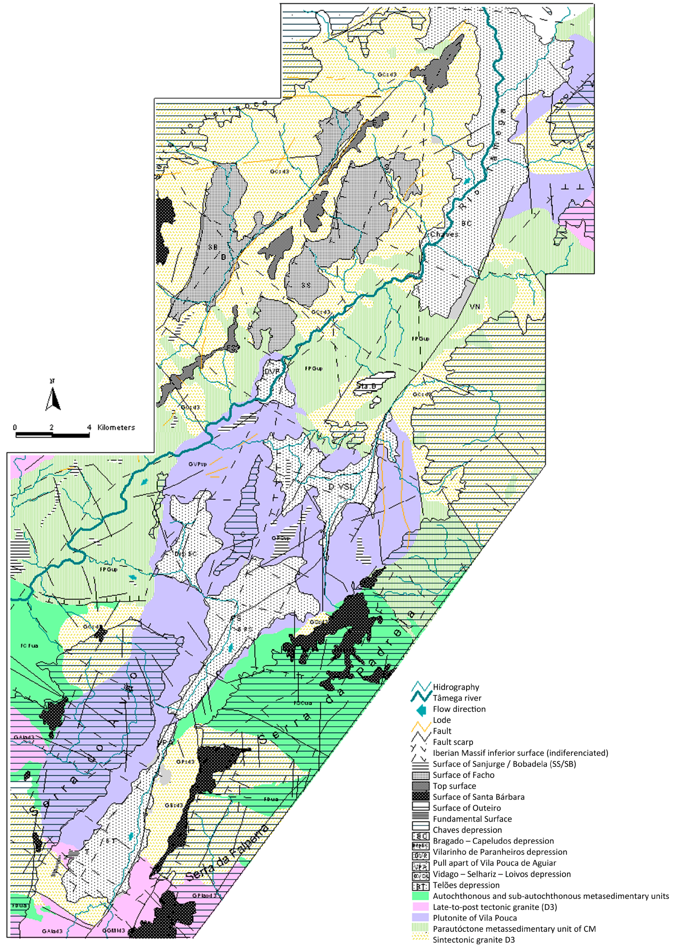
The study area is located in Northern Portugal and integrates autochthonous terranes from the Central Iberian Zone (ITCZ) and parautochthonous terranes of Galicia-Trás-os-Montes Zone (ZGTM) particularly its SE branch [20] characterized by a considerable heterogeneity in lithology.
The vast majority of metasediments is part of autochthonous metasedimentary and subautochthonous units including the lower Marão-Douro group. Only the quartz formation is part of the North-eastern group of Trás-os-Montes. The bigger carriage unit is only represented by a sedimentary unit even though it is extensive. This is the pelitic-greywacke formation of the lower Silurian, which is a unit that integrates complex parautochthonous units of a bigger carriage [21].
Parallel to the metasediments are several outcrops of different types of granitoid rocks, which are the predominant type of rock. They settled fundamentally and successively during and after the last stage of the Variscan ductile deformation (D3) [13] among which are the sin-D3 granites, as Pisões Granite (coarse-grained two-mica granite), Borbela granite (fine to medium grain two-mica granite, locally, with biotite or muscovite), Vale das Gatas Granite (GVG) (medium to coarse granite, porphyritic two-mica), and post-D3 granites. In these regions, installation is associated with the displacement [21,22], i.e., the Águas Frias-Chaves granite—biotitic, medium porphyritic rough grain—and Plutão of Vila Pouca (PVP) in the south, discordant in relation to sin-D3 structures. This corresponds to a laccolith that resulted in two major magmatic intrusions: (i) the intrusion of Vila Pouca granite (GVPA) with laminar geometry (threshold) of magnetic foliation inclined outwardly of the pluton and NNE-SSW orientation and (ii) salted intrusion of granite stones (GPS) corresponding to the magnetic last pulse. It is a medium grain porphyroid granite characterized by the presence of microgranular tonalite enclaves and granodiorites often accompanied by veins with NNE-SSW direction coincident with the main fracturing. The geochronological data U-Pb and isotopic (Rb-Sr and Sm-Nd) show an age of 299 ± 13 Ma, which was obtained by the U-Pb method [21,22].The area is part of a structural context dominated by the Régua-Chaves-Verin fault. This fault corresponds to a late-hercynian left displacement belonging to the same fault system of Manteigas-Vilariça-Bragança. It is also sub-parallel to it with a general orientation NNE-SSW and is located about 60 km west. The fault moved with a strong uplifting component until the end of the Westphalian (Upper Carboniferous). Between the upper Carboniferous and the lower Permian, the fault came to be an important component of the left motion. Posteriorly to the beginning of the upper Triassic, parallel faults were reactivated as thrust faults [23]. Between the Eocene and the lower Miocene is the Pirenaica compression, which reactivates the NE-SW and NNE-SSW systems faults in normal faults and/or in transtensional faults. From the upper Miocene is the Betic compression, which reactivates the segments towards NNE-SSW. Despite the importance that the Hercynian movements had in the study area, there is no doubt that existing morphological features are related to more recent movements. At the end of the Miocene, the direction of the maximum stresses of the Iberian Peninsula would be NNW-SSE. During the Quaternary, the collision between the Iberian Peninsula and Africa resulted in different characteristics depending on the collision zone: the sea, continental shelf, or the continental sector (Gibraltar area). In the study area, recent movements generate new faults and reactivate inherited faults.
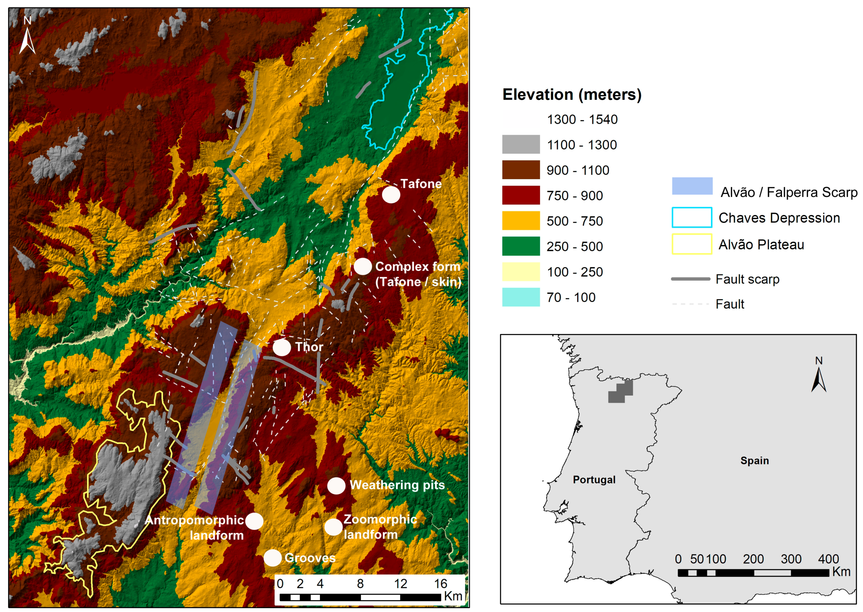
The regional strike-split faults system gives rise to a complex set of tectonic blocks uplifted by compression (to which the Alvão mountain is an example) and basins. Some of these are developed between fault segments since, for example, The Bacia de Telões and others are associated with releasing bends similar to the Bacia de Chaves (Figure 1).
The basin is compartmentalized by segments of fault N-S, NNE-SSW, W-E, and WNW-ESE. The presence of colluvium near the Padrela scarp may be related to the subsidence of the main strike-slip fault. After the Upper Triassic, several faults will have been reactivated, resulting in a zone of distensional curvature. Evidence of neotectonic activity in the study area is mainly related to the strength of the scarps (of which Alvão and Padrela scarps are examples) and to the scaling of various levels of erosion as well as to the presence of faults affecting neogenic deposits and to the seismic activity of the area (Figure 1). At the regional level, it is possible to observe a morphology characterized by the presence of several flattened levels at different altitudes that probably resulted from the tectonic action operated from the upper Miocene [23].
3. Materials and Methods
This research work was conducted in two different phases. The first addressed the selection of geomorphosites at a regional level by the authors by respecting the following criteria: (i) representativeness of the landform as a morphogenetic process; (ii) the morphodynamics witnessed periods with potential to contribute to the reconstruction of paleoenvironmental conditions; (iii) the current morpho-dynamic nature; (iv) the importance of the shaping of the cultural landscape; and (v) to use value [25,26]. The selection of geomorphosites encompassed different scales of analysis such as major morphological features as well as intermediate and detailed forms. The latter were primarily related to granitic landforms.
The analysis of the influence of geomorphological conditions on the landscape mosaic was based on the correlation between morphological and structural characteristics and land use patterns especially with regard to agriculture, forestry, grasslands, and settlement models.
In the second phase of the research, a questionnaire was applied to a group of 104 inhabitants, which aimed to analyze the perception of different values of the geomorphosites as well as the threats that affect them.
The selection of the intended respondents included inhabitants of mountain villages and of the Chaves depression in order to encompass a global perception of the local population. The query was carried out by two inquirers that showed to the respondents’ pictures of the selected landforms of geomorphologic interest and collected the answers. The use of pictures aimed to overcome the lack of scientific knowledge of the respondents about the landforms. The sample was random not considering socio-economic and demographic aspects such as gender, income, education level, and occupation.
The assessment criteria and the related scores were supported by the methodology presented in Pereira et al., 2007 [27] in which it is considered that the Geomorphologic Interest Value (GIV) corresponds to Equation (1).
where SVC is the Scientific and Cultural Value and MV the Management Value.
GIV = SCV + MV
Scientific and Cultural Value (SCV) results from Equation (2) are below.
where SV is the Scientific Value and AV is the Additional Value.
SCV = SV + AV
Scientific Value (SV) results from Equation (3) are below.
where RG is the Rarity of the Geomorphosite, SD is the State of Damage, RDR is the Representativeness as a Didactic Resource, Di is the Diversity, and An is the Abundance at a national level.
SV = RG + SD + RDR+DI + An
Additional Value (AV) results from Equation (4) are below.
where C is the Cultural value, A is the Aesthetic value, and E is the Ecological value.
AV = C + A + E
The Management Value (MV) was calculated using Equation (5).
where VU is the value of use and PV is the preservation value.
MV = VU + PV
The Value of Use (VU) was calculated by using Equation (6).
where AC is the Accessibility Condition, VC is the Visibility Condition, CUG is the Current Use of Geomorphosite (CUG), CNI is the other Cultural and Natural Interests, and ESS is the Equipment and Support Services.
VU = AC + VC + CUG + CNI + ESS
The value of preservation (PV) implies that the quantitative evaluation of the parameters of damage (impacts to date) (Dit) and vulnerability to anthropogenic impacts (impacts due to the use of geomorphological sites) (VAI) are based on Equation (7).
PV = Dit + VAI
4. Results
4.1. The Regional Geodiversity and Geomorphosites
Considering the selection criteria presented in the methodology, three main landforms were identified as geomorphosites including (i) the Alvão plateau; (ii) the Chaves depression; and (iii) Alvão and Falperra fault scarp. In terms of detailed landforms, six types were selected: (i) linear grooves/slots; (ii) parallel grooves; (iii) gnammas (weathering pits); (iv) tafone; (v) thors, and (vi) zoomorphic and anthropomorphic forms. The selected landforms of geomorphological interest are identified and geo-referenced in Figure 2.
Regarding the major relief landforms, i.e., the Alvão plateau, the Chaves depression and Alvão and Falperra fault scarp, the demonstrative capacity of the specific kind of morphogenetic process related to the type of landform and regional geomorphological context was a leading selection criterion in terms of the scientific and didactic values. The existence of scientific knowledge about the morphogenesis helped to assess the scientific value of this geomorphosites. Additionally, also taken into account in this selection were the influence of the landforms to the cultural landscape shaping and the current use value the leisure/tourism uses and the ecological services.
In what concerns the detailed landforms, the demonstrative capacity of the genesis and evolution in granitic areas was the most important selection criterion. It is common for the association between the presence of granitoid rocks and areas of high geodiversity where a variety of processes at different scales are developed. Across the Serra do Alvão (Figure 2), the thors are frequent as well as sinks, tafone, or grooves. It appears that many of these forms have their genesis under the mantle, which changes micro-environmental conditions in more favourable ways for the development of morphogenetic processes related to the advancement of change mechanisms. Except for the cold climate zones under the alteration of the mantle, the thermal stability and higher humidity values enhance such processes.
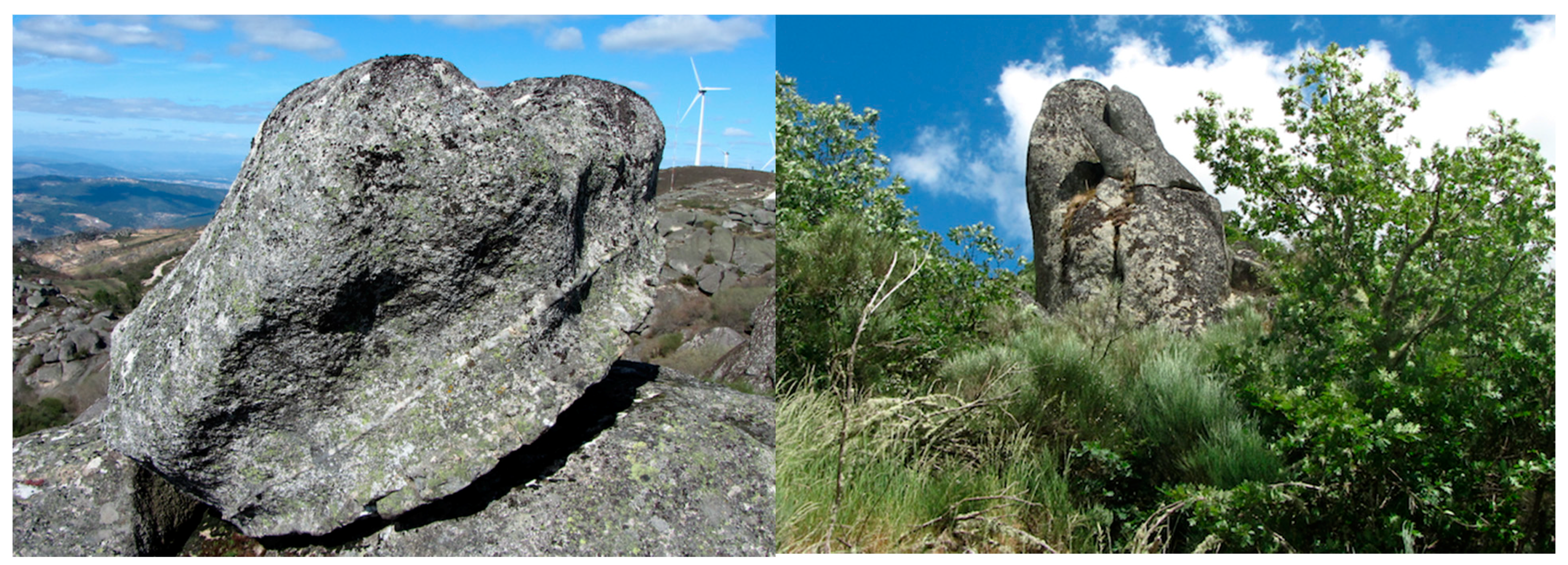
Internal geodynamic processes by subjecting the rock material to the concentration of forces in the elastic installation phase originate in sub spherical cavities [28]. This does not agree with the explanation of some smaller shapes since it is the case of tafoni (tafone in the singular) (Figure 3).
If a group of authors suggests that the shape has a fully subaerial genesis [28,29], others admit the possibility of a previous stage in the development of these forms (sub edaphic and subaerial evolution) [20,21] and is also linked to the installation of the rock mass (elastic phase) [28,29].
In addition to the mineralogical characteristics of the rock, these are still important for the tension forces in the tafone genesis of (i) lithostatic and (ii) tectonic, which gives rise to deformations and ruptures that condition the structural characteristics and lithological discontinuities and will influence the weathering process. The active area is split into small and numerous active fronts, which continue to serve the breakdown processes and lead to a weathering hive. This allows each unit to evolve without relation to others. The hydrolysis action is of paramount importance as is the action hydration/dissection by the cumulative effect of indoor/outdoor thermal and hygrometric deviations. Exposure to intense surface evaporation places wherein any wall sinuosity creates differences in moisture and accelerates the development of these forms. A rapid and localized breakdown of the rock blade or grain forms two inactive surfaces, which keeps the above characteristics of the phenomenon and an active surface advancing into the block and increases its dimensions.
These forms are more common in the study area in leucocratic granites and porphyroid where one can observe mega crystals, potassium feldspars, and muscovite, which is the predominant mica. The presence of sinks is very common (Figure 4).
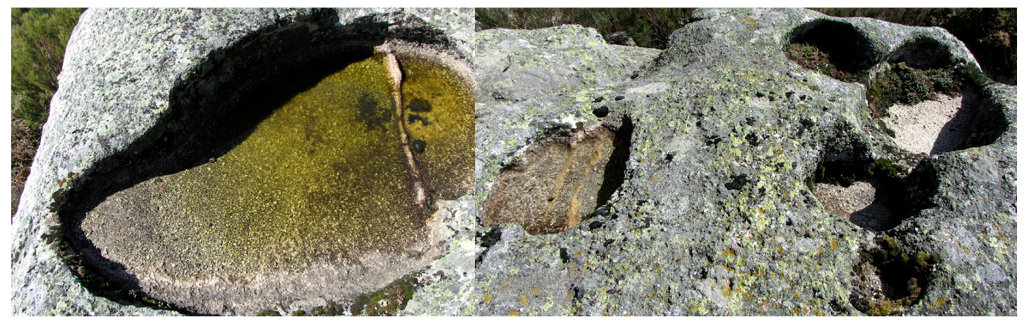
It is present in granitic areas, takes on different names, and varies according to the language and the area of the globe. This may be defined as cavities or bowls as rock excavated in the solid rock bed, generally circular, oval, or elliptical [30]. They are shapes that allow the retention of water, which usually disappears through evaporation (Figure 5).
Water is the principal agent of weathering [30]. In some cases, there appears to be a relationship between the shape and the structure. Other relationships are not so clear so there are different interpretations related to its genesis. This is related to epigenetic reasons, subaerial or soil, as well as with others linked to internal geodynamic elements and associated with structural aspects and rock mass installation.
Although small in number, they are also present in the study of area grooves, which are also known as channels, and runnels or gutters, grooves, or flutings. They morphologically resemble roof gutters. The presence of the flutes occurs over the downhill slightly inclined rocky surfaces and results from granular rock breakdown, which leads to deepening the grooves.
The stones known as “bolideira” or oscillating blocks or isolated blocks are still frequent. Without a complex genesis of important morphological meaning, they are recurrent forms in granites and many generate interest and curiosity in the population when it gives rise to animal-related forms such as turtles or anthropomorphic models (Figure 6).
4.2. Evaluation of Selected Geomorphosites
The following tables present the results of the applied questionnaire on what comprises the scientific value, the additional value, the use value, the preservation value, and, lastly, geomorphologic interest value.
The large landforms, particularly the Alvão plateau and the depression of Chaves, show higher values of scientific value (SV) (Table 1). The parameters of rarity (VR), diversity (Di), and the representativeness as didactic resource (RDR) contribute the most to this result. It is remarkable that the major geomorphosites, especially the Chaves depression and the Alvão plateau, are understood as areas highly exposed to damage (SD values 0.6 and 0.7, respectively). When queried about the main threats, depopulation, forest fires, agricultural abandonment, expansion of monocultural stands, occupation of land with agricultural potential for other uses, and construction of communication infrastructure with scenic impact are the most often reported factors.
With regard to the intermediate and detailed landforms, the rate is clearly lower. The main identified threats are the forest fires, the intensification of pastoral use, vandalism, and eventual conflicts between shepherds and educational, leisure, and tourism use.
The major relief forms present the highest values of the additional value (AV). These sites are perceived by the respondents as places of high cultural, aesthetic, and ecological values (Table 2). Aesthetic assessment (both qualitative and quantitative) is a challenging procedure and depends on several parameters and perception, [31,32]. Both results and ecological value show higher values for the large relief forms. The management value (MV) results from the sum of the value of use (VU) and the preservation value (PV).
The major relief forms present the highest scores of value of use (VU) given that they are places of greater accessibility (AC) and visibility (VC). They present other natural and cultural interests (CNI) and present better equipment and support services (ESS) (Table 3).
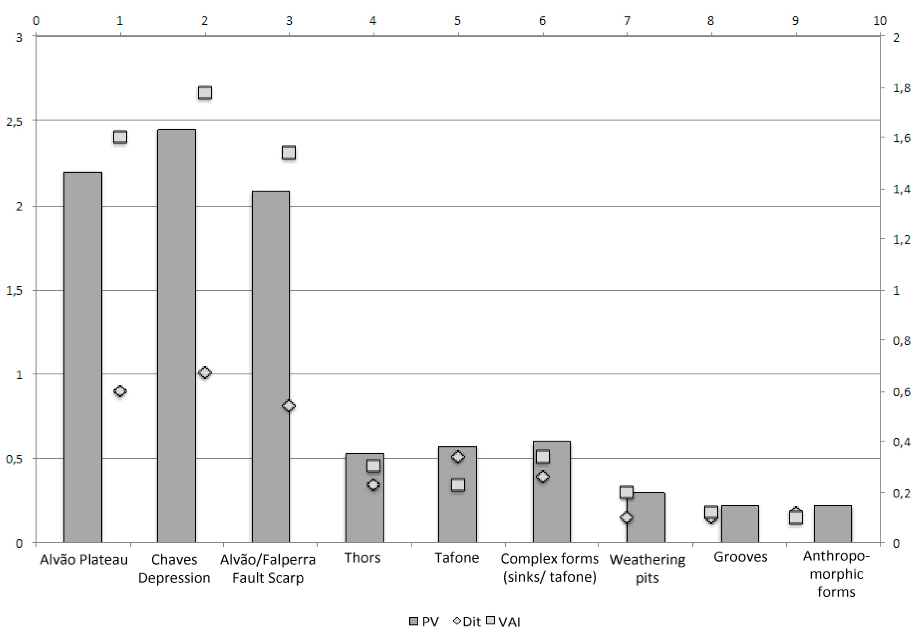
When considering the preservation value (PV) (Figure 7), the major landforms are the outstanding geomorphosites.
Respondents consider that the major relief forms are places of high vulnerability to anthropogenic impact (VAI) even though they are considered to have a medium preservation value (PV).
The results suggest that the major relief forms as the sites perceived have the greatest geomorphological value especially the Chaves depression (Table 4). The results are driven not only by the scientific parameters but also by the ecological, cultural, and value-for-use parameters.
5. Conclusions
The selection of geomorphosites was based on a combination of scientific criteria, leaded by a geomorphological point of view, following, however an interdisciplinary approach that encompasses the assessment of its multiple values and of its importance in shaping the cultural landscape, as suggested by several authors [33,34]. This methodology proved to be capable of increasing the recognition of the asset value of landforms. The results of this study show that the aesthetic, landscape, ecological, and current use values are perceived and valued by the population.
The major geomorphological features are the sites perceived as having the greatest geomorphological value, especially the Chaves depression. These major geomorphosites, especially the Alvão plateau and the depression of Chaves, show higher values of scientific value (SV) as well as of the additional value (AV). These sites are perceived by the respondents as places of high cultural, aesthetic, and ecological values. It is remarkable that the major geomorphosites, including the Chaves depression and the Alvão plateau, are understood as areas highly exposed to damage. Depopulation, forest fires, agricultural abandonment, expansion of monocultural stands, occupation of land with agricultural potential for other uses, and construction of communication infrastructure with scenic impact were the main threats identified.
Local inhabitant’s preferences regarding the major landforms show the importance of the daily connection to the regional territory and landscape. This linkage results from a fruition relation of the aesthetic dimension of the landforms, as well, as of its daily use to agro-silvo-pastoral activities. This finding should be considered in future works of geomorphosites selection and assessment.
The major landforms are those showing higher exposition to damage risk, having suffered more impacts to date than medium scale or detailed landforms. This may be explained through influence of land management at regional scale on the preservation of these major landforms. To overcome this gap, the assessment of geomorphosites must combine the physical and human dynamics.
Perception studies concerning the evaluation of multiple values of geomorphosites by local population are essential for guiding the land management and environmental policies towards geo-heritage preservation [35]. It is fundamental that local habitants are asked to participate in defining geo-heritage sites that should be a preservation priority.
This work also highlights the crucial role that local communities and stakeholders play in what concerns to local development, which might be very important to geoconservation, as some studies have already pointed out [36,37]. Their commitment is essential to geoheritage conservation, as well as to its valorization by geotourism. The assessment of local inhabitants’ perception regarding the value of geomorphosites may support the implementation of geoheritage preservation and management measures. Therefore, it enhances natural conservation strategies and territorial development, through the promotion for the community involvement, commitment and empowerment.
This study intends to emphasize the relevance of the increase of resident’s conscientiousness about the value of the geomorphosites present on their daily life space, making of them more prone to be the guardians of their own heritage. Additionally, the improvement of the knowledge of local inhabitants about the geoheritage, prepares them to better communicate geomorphosites value to visitors and tourists. The selection process of potential geomorphosites should consider local inhabitants’ perception of their value, so that the cultural, social and economic dimensions can also be evaluated, in addition to the scientific and educational values. This concern should always be considered when working in economically underprivileged areas. Therefore, this study aimed to promote the empowerment of local inhabitants in what concerns the choice of which geoheritage sites deserve conservation and valorization measures.
As final results, greater understanding of local inhabitants’ perception and better recognition of the value of geodiversity have been achieved: both valuable contributions to support a more integrated territorial management encompassing geoheritage preservation and valuation goals, suitable for tourism and sustainable development, as also recognized by previous studies [38].
Supplementary Materials
Supplementary File 1Author Contributions
Conceptualization, B.M. and A.P.; Methodology, B.M. and A.P.; Software, B.M. and A.P.; Field Investigation and mapping, B.M. and A.P. Writing-Review & Editing, B.M. and A.P.
Funding
This work was co-financed by the Centre of Studies on Geography and Spatial Planning (CEGOT).
Conflicts of Interest
The authors declare no conflict of interest.
References
- Reynard, E.; Panizza, M. Geomorphosites: Definition, assessment, and mapping. Geomorphol. Relief Process. Environ. 2005, 3, 177–180. [Google Scholar] [CrossRef]
- Brilha, J. Inventory and quantitative assessment of geosites and geodiversity sites: A review. Geoheritage 2016, 8, 119–134. [Google Scholar] [CrossRef] [Green Version]
- Bollati, I.; Coratza, P.; Giardino, M.; Laureti, L.; Leonelli, G.; Panizza, M.; Panizza, V.; Pelfini, M.; Piacente, S.; Pica, A. Directions in Geoheritage Studies: Suggestions from the Italian Geomorphological Community. Eng. Geol. Soc. Territory 2015, 8, 213–217. [Google Scholar] [CrossRef]
- Justice, S.C. UNESCO Global Geoparks, Geotourism and Communication of the Earth Sciences: A Case Study in the Chablais UNESCO Global Geopark, France. Geosciences 2018, 8, 149. [Google Scholar] [CrossRef]
- Stallins, J.A. Geomorphology and ecology: Unifying themes for complex systems in biogeomorphology. Geomorphology 2006, 77, 207–216. [Google Scholar] [CrossRef]
- Reynard, E.; Fontana, G.; Kozlik, L.; Scapozza, C. A method for assessing the scientific and additional values of geomorphosites. Geogr. Helv. 2007, 3, 1–13. [Google Scholar] [CrossRef]
- Kozlik, L.; Reynard, E. Inventaire et valorisation des géomorphosites culturels des vallées du Trient, de l’Eau Noire et de la Salanfe. In Gestion des Géosites dans les Espaces Protégés; Hobléa, F., Cayla, N., Reynard, E., Eds.; Collection EDYTEM: Le Bourget-du-Lac, France, 2013; pp. 135–142. Available online: http://my.unil.ch/serval/document/BIB_2FB2118F35BA.pdf (accessed on 4 May 2018).
- Giardino, M.; Bacenetti, M.; Perotti, L.; Giordano, E.; Ghiraldi, L.; Palomba, M. Geodiversity and geohazards of the Susa Valley (W-Alps, Italy): Combining scientific research and new technologies for enhanced knowledge and proactive management of geoheritage in mountain regions. In Proceedings of the EGU General Assembly Conference, Vienna, Austria, 7–12 April 2013; Volume 15. [Google Scholar]
- Shahhoseini, H.; Modabberi, S.; Shahabi, M. Study of factors influencing the attitude of local people toward geotourism development in Qeshm National Geopark, Iran. Geoheritage 2017, 9, 35–48. [Google Scholar] [CrossRef]
- Popa, G.; Popa, A.; Andrășanu, A. The SEA and Big-S Models for Managing Geosites as Resources for Local Communities in the Context of Rural Geoparks. Geoheritage 2017, 9, 175–186. [Google Scholar] [CrossRef]
- Farsani, N.; Coelho, C.; Costa, C. Geotourism and geoparks as novel strategies for socio-economic development in rural areas. Int. J. Tour. Res. 2011, 13, 68–81. [Google Scholar] [CrossRef]
- Han, J.; Wu, F.; Tian, M.; Li, W. From geopark to sustainable development: Heritage conservation and geotourism promotion in the Huangshan UNESCO Global Geopark (China). Geoheritage 2018, 10, 79–91. [Google Scholar] [CrossRef]
- Brilha, J. Inventory and quantitative assessment of geosites and geodiversity sites: A review. Geoheritage 2015. [Google Scholar] [CrossRef] [Green Version]
- Carcavilla, L.; Durán, J.; García-Corte’s, A.; López-Martínez, J. Geological heritage and geoconservation in Spain: Past, present, and future. Geoheritage 2009, 1, 75–91. [Google Scholar] [CrossRef]
- Reynard, E. Géomorphosites et paysages. Géomorphol. Relief Process. Environ. 2005, 3, 181–188. [Google Scholar] [CrossRef]
- Gordon, J.E. Geoheritage, Geotourism and the Cultural Landscape: Enhancing the Visitor Experience and Promoting Geoconservation. Geosciences 2018, 8, 136. [Google Scholar] [CrossRef]
- Neches, I.M. From geomorphosite evaluation to geotourism interpretation. Case study: The Sphinx of Romania’s Southern Carpathians. GeoJ. Tour. Geosites 2013, 12, 145–162. [Google Scholar]
- Prats, L. Antropología y Patrimonio; Editorial Ariel: Barcelona, Spain, 1997. [Google Scholar]
- Canales, L.; Talavera, A. Reflexiones libérrimas sobre patrimonio, turismo y sus confusas relaciones”. In El Encuentro del Turismo com el Património Cultural: Concepciones Teóricas y Modelos de Aplicación; Asociación Andaluza de Antropología: Sevilla, Spain, 2005; pp. 9–25. [Google Scholar]
- Dias, R.; Ribeiro, A.; Coke, C.; Rodrigues, J.; Pereira, E.; Rebelo, J.; Moreira, N. Evolução estrutural dos sectores setentrionais do autóctone da zona Centro-Ibérica. Geol. Port. 2011, 1, 73–174. [Google Scholar]
- Martins, H.C.; Noronha, F.; Leterrier, J. Evolução geoquímica dos granitóides biotíticos tarditectónicos e pós-tectónicos do quadrângulo Vieira do Minho-Moreira de Rei-Vila Pouca de Aguiar-Boticas. Estudo Comparativo; Actas X Semana da Geoquímica/IV Congresso de Geoquímica dos Países de Língua Português: Braga, Portugal, 1998; pp. 87–90. [Google Scholar]
- Silva, H. O maciço Granítico Pós-Tectónico de Vila Pouca de Aguiar—Estudo Petro-Estrutural e Mecanismo de Instalação, Tese de Doutoramento; Faculdade de Ciências da Universidade do Porto: Porto, Portugal, 2000; p. 314. [Google Scholar]
- Baptista, J. Estudo Neotectónico da Zona de Falha Penacova-Régua-Verin. Ph.D. Thesis, Universidade de Alto Douro e Trás-os-Montes, Vila Real, Portugal, 1990; 344p. [Google Scholar]
- Martins, B. A Depressão de Régua-Chaves-Verín: Contributo para a Análise do Risco de Ravinamento; Fundação Eng. António de Almeida: Porto, Portugal, 2017; p. 364. [Google Scholar]
- Sellier, D. A Deductive Method for the Selection of Geomorphosites: Application to Mont Ventoux (Provence, France). Geoheritage 2015. [Google Scholar] [CrossRef]
- Bruschi, V.; Cendrero, A. Geosite evaluation: Can we measure intangible values? Il Quaternario 2005, 18, 293–306. [Google Scholar]
- Pereira, P.; Pereira, D.I.; Alves, M.I. Geomorphosite assessment in Montesinho natural park (Portugal). Geogr. Helv. 2007, 62, 159–168. [Google Scholar] [CrossRef] [Green Version]
- Romaní, J.R.; Temiño, J. Historia de la morfogénesis granítica. Morphogenetic history of granite forms. Caderno Lab. Xeolóxico de Laxe. Coruña 2004, 29, 331–360. [Google Scholar]
- Grenier, M.P. Observations sur les taffonis du désert chilien. Bull. Assoc. Geogr. Fr. 1968, 364–365, 193–211. [Google Scholar] [CrossRef]
- Alvarez, U. Tafoni en rocas graníticas. Primera valoración estadística sobre tasas de desarrollo en el Macizo de Ourense (Galicia, NW de la Península Ibérica). Caderno Lab. Xeolóxico de Laxe Coruña 2004, 29, 265–289. [Google Scholar]
- Mikhailenko, A.V.; Nazarenko, O.V.; Ruban, D.A.; Zayats, P.P. Aesthetics-based classification of geological structures in outcrops for geotourism purposes: A tentative proposal. Geologos 2017, 23, 45–52. [Google Scholar] [CrossRef]
- Kirillova, K.; Fu, X.; Lehto, X.; Cai, L. What makes a destination beautiful? Dimensions of tourist aesthetic judgment. Tour. Manag. 2014, 42, 282–293. [Google Scholar] [CrossRef]
- Gordon, J. Rediscovering a sense of wonder: Geoheritage, geotourism and cultural landscape experiences. Geoheritage 2012, 4, 65–77. [Google Scholar] [CrossRef]
- Erikstad, L. Geoheritage and geodiversity management—The questions for tomorrow. Proc. Geol. Assoc. 2013, 124, 713–719. [Google Scholar] [CrossRef]
- Gordon, J.; Crofts, R.; Díaz-Martínez, E. Geoheritage conservation and environmental policies: Retrospect and prospect. Geoheritage 2018, 12, 213–235. [Google Scholar] [CrossRef]
- Jaafar, M.; Noor, S.M.; Rasoolimanesh, S.M. Perception of young local residents toward sustainable conservation programmes: A case study of the Lenggong World Cultural Heritage Site. Tour. Manag. 2015, 48, 154–163. [Google Scholar] [CrossRef]
- Tavares, A.O.; Henriques, M.H.; Domingos, A.; Bala, A. Community Involvement in Geoconservation: A Conceptual Approach Based on the Geoheritage of South Angola. Sustainability 2015, 7, 4893–4918. [Google Scholar] [CrossRef] [Green Version]
- Fanwei, Z. An evaluation of residents’ perceptions of the creation of a geopark: A case study on the geopark in Mt. Huaying Grand Canyon, Sichuan Province, China. Environ. Earth Sci. 2014, 71, 1453–1463. [Google Scholar] [CrossRef]
Figure 1.
Morphostructural map of the study area (adapted from: Martins, 2017 [24]).
Figure 1.
Morphostructural map of the study area (adapted from: Martins, 2017 [24]).

Figure 2.
Location map of the study area and identification of geomorphosites.

Figure 3.
Tafone sketch in lateral wall and base. Please note the presence a quartz intrusion (left). Tafone sketches in lateral wall (right).
Figure 3.
Tafone sketch in lateral wall and base. Please note the presence a quartz intrusion (left). Tafone sketches in lateral wall (right).

Figure 4.
Example of a complex form of sinks and tafone outlines in leucocrate granite and coarse-grained porphyritic with the presence of feldspar megacrystals—eastern slopes of Serra do Alvão.
Figure 4.
Example of a complex form of sinks and tafone outlines in leucocrate granite and coarse-grained porphyritic with the presence of feldspar megacrystals—eastern slopes of Serra do Alvão.

Figure 5.
Elliptical shape sink. Note the protrusion of a small quartz strand more resistant to the advancement of the weathering (left). Set of sinks in different evolution states (right).
Figure 5.
Elliptical shape sink. Note the protrusion of a small quartz strand more resistant to the advancement of the weathering (left). Set of sinks in different evolution states (right).

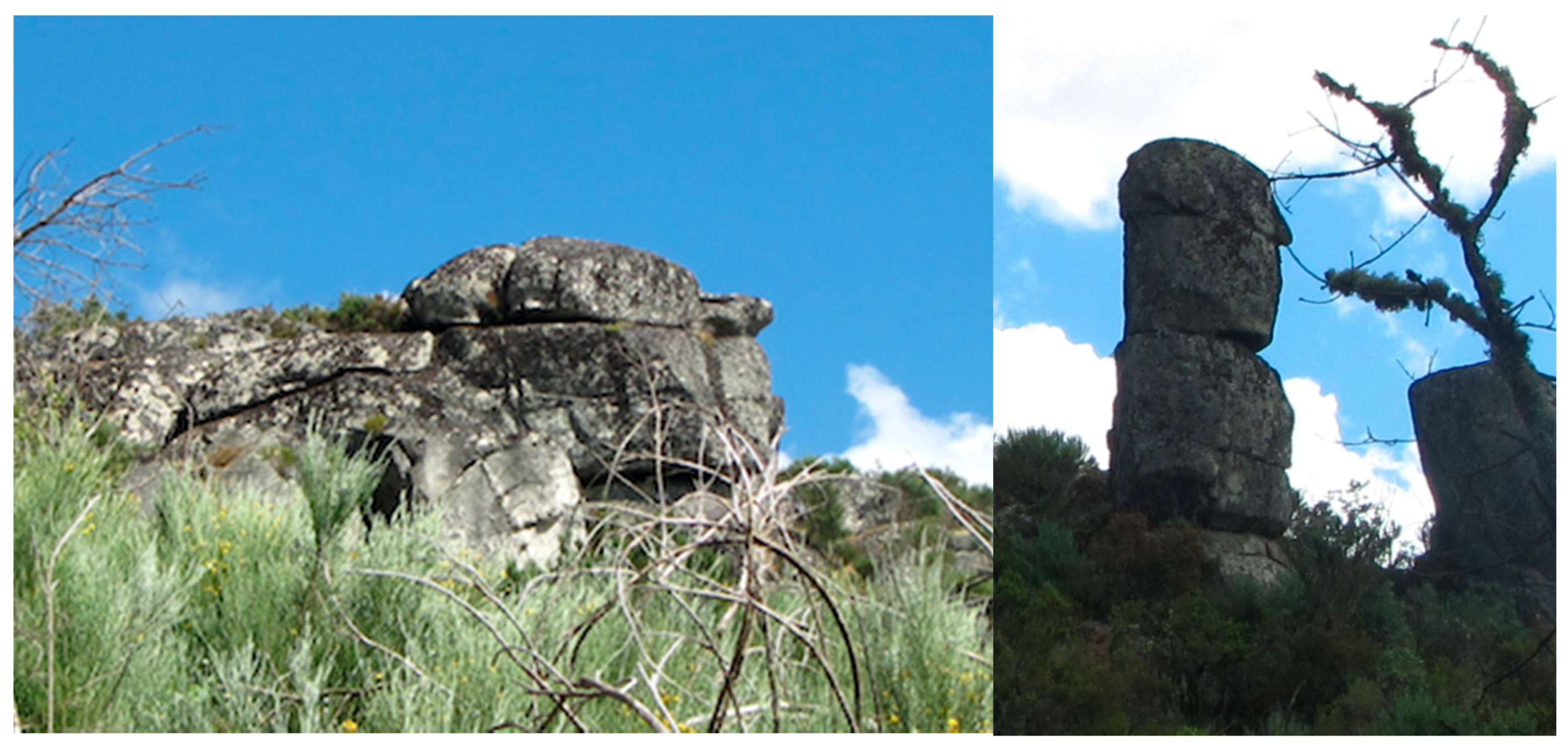
Figure 6.
Zoomorphic block (turtle) and (left) and anthropomorphic block (man’s head) (right).

Figure 7.
Preservation value (PV) for the different geomorphosites considering the parameters of damage (impacts to date) (Dit) and vulnerability to anthropogenic impacts (VAI).
Figure 7.
Preservation value (PV) for the different geomorphosites considering the parameters of damage (impacts to date) (Dit) and vulnerability to anthropogenic impacts (VAI).


Table 1.
Scientific value (SV) of geomorphosites.
| Scientific Value (SV) | |||||||
|---|---|---|---|---|---|---|---|
| RG (0–1) | SD (0–1) | RDR (0–1) | Di (0–1) | An (0–0.5) | SV | ||
| Major landforms | Alvão Plateau | 0.7 | 0.6 | 0.6 | 0.7 | 0.2 | 2.77 |
| Chaves Depression | 0.8 | 0.7 | 0.7 | 0.8 | 0.2 | 3.21 | |
| Alvão/Falperra scarp | 0.4 | 0.3 | 1.0 | 0.5 | 0.1 | 2.30 | |
| Intermediate landforms | Tors | 0.5 | 0.2 | 1.0 | 0.3 | 0.1 | 2.17 |
| Detailed landforms | Tafoni | 0.4 | 0.2 | 0.7 | 0.7 | 0.1 | 2.09 |
| Complex forms (tafoni/sinks) | 0.6 | 0.3 | 0.6 | 0.7 | 0.1 | 2.32 | |
| Gnammas (weathering pits) | 0.4 | 0.1 | 0.9 | 0.4 | 0.1 | 1.90 | |
| Grooves | 0.5 | 0.1 | 0.9 | 0.1 | 0.1 | 1.70 | |
| Anthropomorphic forms | 0.7 | 0.1 | 0.8 | 0.1 | 0.2 | 1.90 | |
RG—Rarity of the Geomorphosite, SD—State of Damage, RDR—Representativeness as didactic resource, Di—Diversity, An—Abundance at national level.
Table 2.
Additional Value (AV) of the different geomorphosites.
| C (0–0.5) | A (0–1.5) | E (0–1.5) | AV | ||
|---|---|---|---|---|---|
| Major landforms | Alvão Plateau | 0.4 | 1.2 | 1.1 | 2.73 |
| Chaves Depression | 0.4 | 1.3 | 1.1 | 2.83 | |
| Alvão/Falperra scarp | 0.3 | 1.1 | 1.1 | 2.52 | |
| Intermediate landforms | Tors | 0.1 | 0.5 | 0.4 | 1.01 |
| Detailed landforms | Tafoni | 0.1 | 0.6 | 0.3 | 1.09 |
| Complex forms (tafoni/sinks) | 0.1 | 0.7 | 0.3 | 1.18 | |
| Gnammas (weathering pits) | 0.1 | 0.6 | 0.1 | 0.82 | |
| Grooves | 0.1 | 0.2 | 0.1 | 0.37 | |
| Anthropomorphic forms | 0.1 | 1.1 | 0.1 | 1.31 |
(C) cultural value, (A) aesthetic value, (E) ecological value.
Table 3.
Value of use (VU) of the geomorphosites.
| Value of Use (VU) | |||||||
|---|---|---|---|---|---|---|---|
| AC (0–1.5) | VC (0–1.5) | CUG (0–1) | CNI (0–1) | ESS (0–1) | VU | ||
| Major landforms | Alvão Plateau | 1.3 | 1.3 | 0.3 | 0.2 | 0.9 | 4.03 |
| Chaves Depression | 1.4 | 1.4 | 0.3. | 0.1 | 1.0 | 4.22 | |
| Alvão/Falperra scarp | 1.3 | 1.2 | 0.0 | 0.1 | 0.8 | 3.39 | |
| Intermediate landforms | Tors | 0.4 | 0.9 | 0.0 | 0.0 | 0.2 | 1.55 |
| Detailed landforms | Tafoni | 0.4 | 0.9 | 0.0 | 0.0 | 0.2 | 1.60 |
| Complex forms (tafoni/sinks) | 0.3 | 0.9 | 0.0 | 0.0 | 0.2 | 1.43 | |
| Gnammas (weathering pits) | 0.4 | 1.0 | 0.0 | 0.0 | 0.2 | 1.61 | |
| Grooves | 0.6 | 0.9 | 0.0 | 0.0 | 0.2 | 1.73 | |
| Anthropomorphic forms | 0.6 | 0.6 | 0.0 | 0.0 | 0.2 | 1.48 | |
AC, accessibility conditions, VC, visibility conditions, CUG, current use of geo-morphosite, CNI, other cultural and natural interests, ESS, equipment and support services.
Table 4.
Geomorphological interest value (GIV) obtained from the sum of scientific value (SV) and management value (MV).
Table 4.
Geomorphological interest value (GIV) obtained from the sum of scientific value (SV) and management value (MV).
| SC | AV | VU | PV | |||
|---|---|---|---|---|---|---|
| Major landforms | Alvão Plateau | 0.7 | 2.7 | 2.7 | 4.0 | 15.03 |
| Chaves Depression | 0.8 | 3.2 | 2.8 | 4.2 | 16.3 | |
| Alvão /Falperra Fault Scarp | 0.4 | 2.3 | 2.5 | 3.4 | 13.03 | |
| Intermediate landforms | Tors | 0.5 | 2.2 | 1.0 | 1.5 | 7.91 |
| Detailed landforms | Tafoni | 0.4 | 2.1 | 1.1 | 1.6 | 7.96 |
| Complex forms (tafoni/sinks) | 0.6 | 2.3 | 1.2 | 1.4 | 8.43 | |
| Gnammas (weathering pits) | 0.4 | 1.9 | 0.8 | 1.6 | 7.05 | |
| Grooves | 0.5 | 1.7 | 0.4 | 1.7 | 5.87 | |
| Anthropomorphic forms | 0.7 | 1.9 | 1.3 | 1.5 | 7.90 |
SC, Scientific Value, AV, Additional Value, VU, Value of Use, PV, Preservation Value.
© 2018 by the authors. Licensee MDPI, Basel, Switzerland. This article is an open access article distributed under the terms and conditions of the Creative Commons Attribution (CC BY) license (http://creativecommons.org/licenses/by/4.0/).
Share and Cite
MDPI and ACS Style
Martins, B.; Pereira, A. Residents’ Perception and Assessment of Geomorphosites of the Alvão—Chaves Region. Geosciences 2018, 8, 381. https://doi.org/10.3390/geosciences8100381
AMA Style
Martins B, Pereira A. Residents’ Perception and Assessment of Geomorphosites of the Alvão—Chaves Region. Geosciences. 2018; 8(10):381. https://doi.org/10.3390/geosciences8100381
Chicago/Turabian StyleMartins, Bruno, and Andreia Pereira. 2018. "Residents’ Perception and Assessment of Geomorphosites of the Alvão—Chaves Region" Geosciences 8, no. 10: 381. https://doi.org/10.3390/geosciences8100381
Note that from the first issue of 2016, this journal uses article numbers instead of page numbers. See further details here.