
Mapping the Viability, Time, and Cost of Manual Borehole Drilling in Developing Regions

 ,
,  , and
, and
Abstract
:1. Introduction
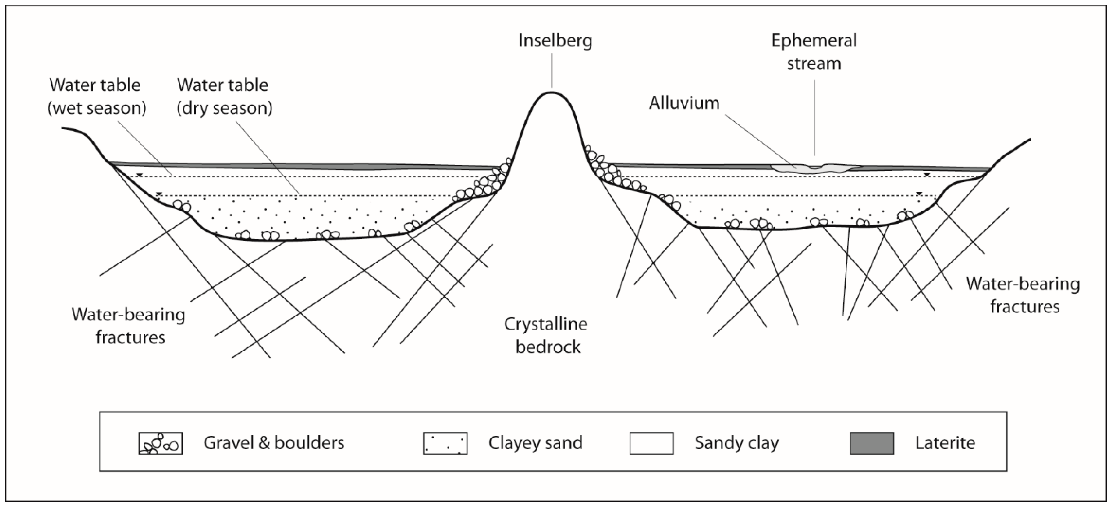
1.1. Background
1.2. Methodological Precedents, Research Objectives, and Novelties
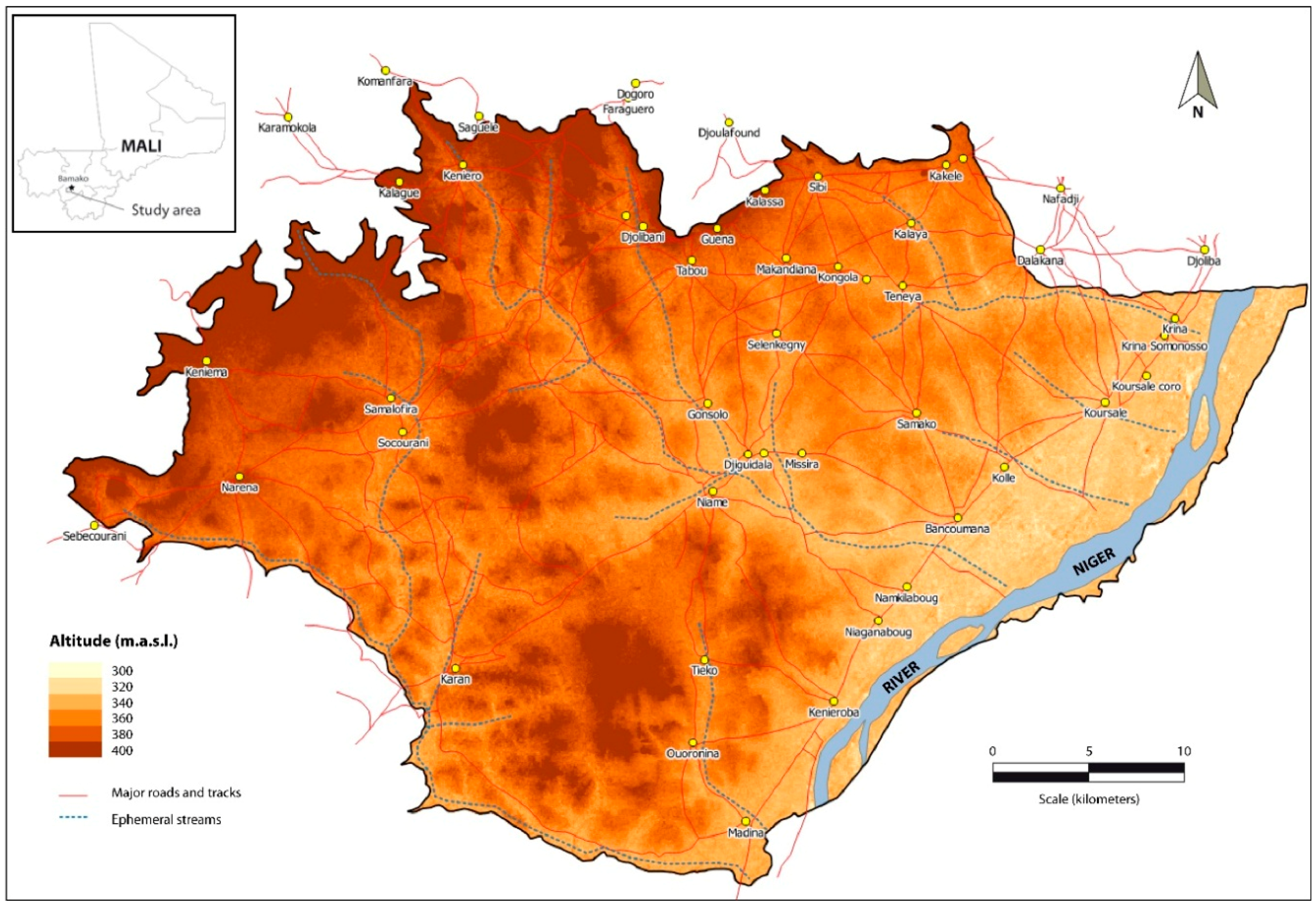
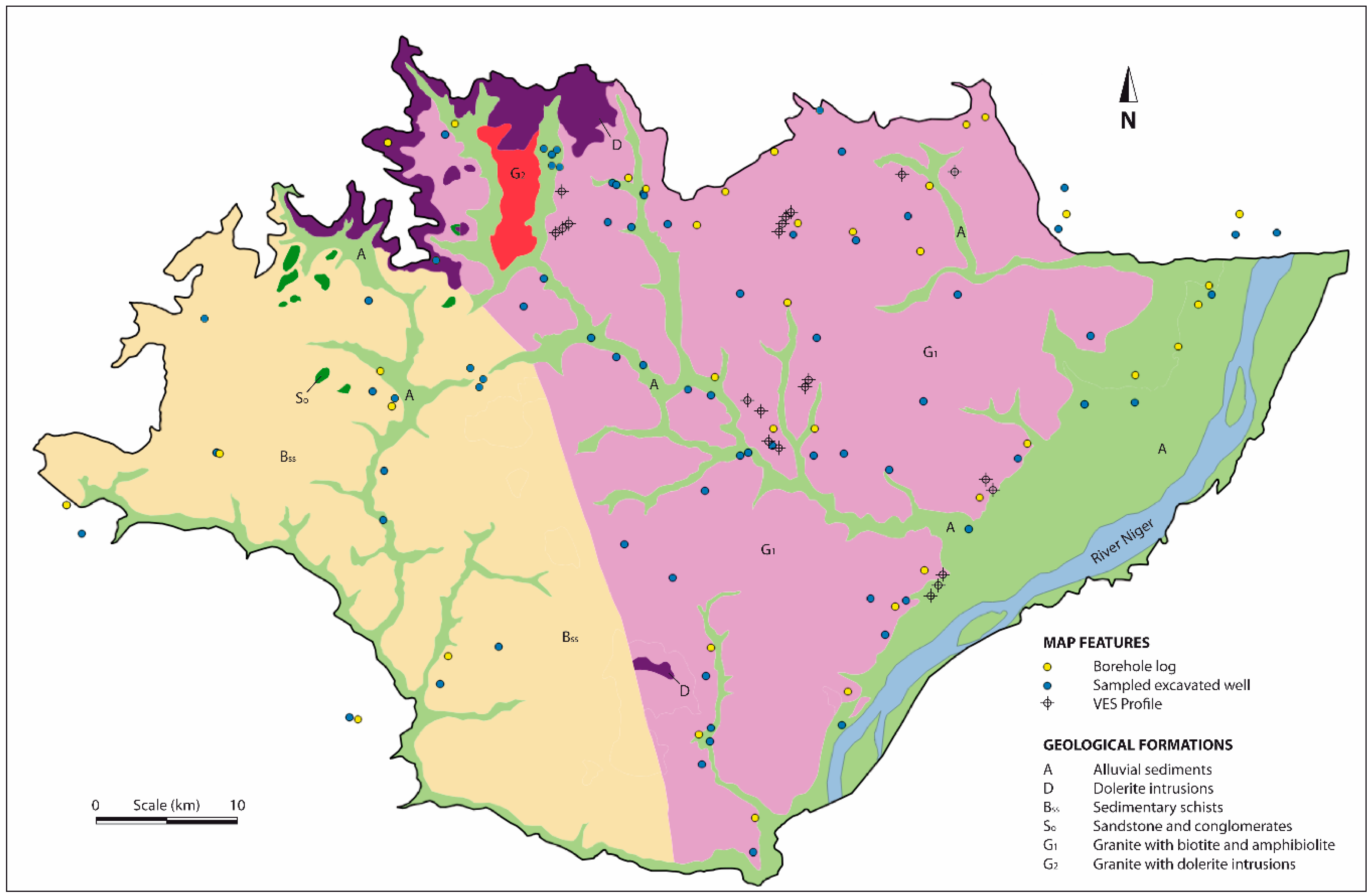
2. Study Area
3. Materials and Methods
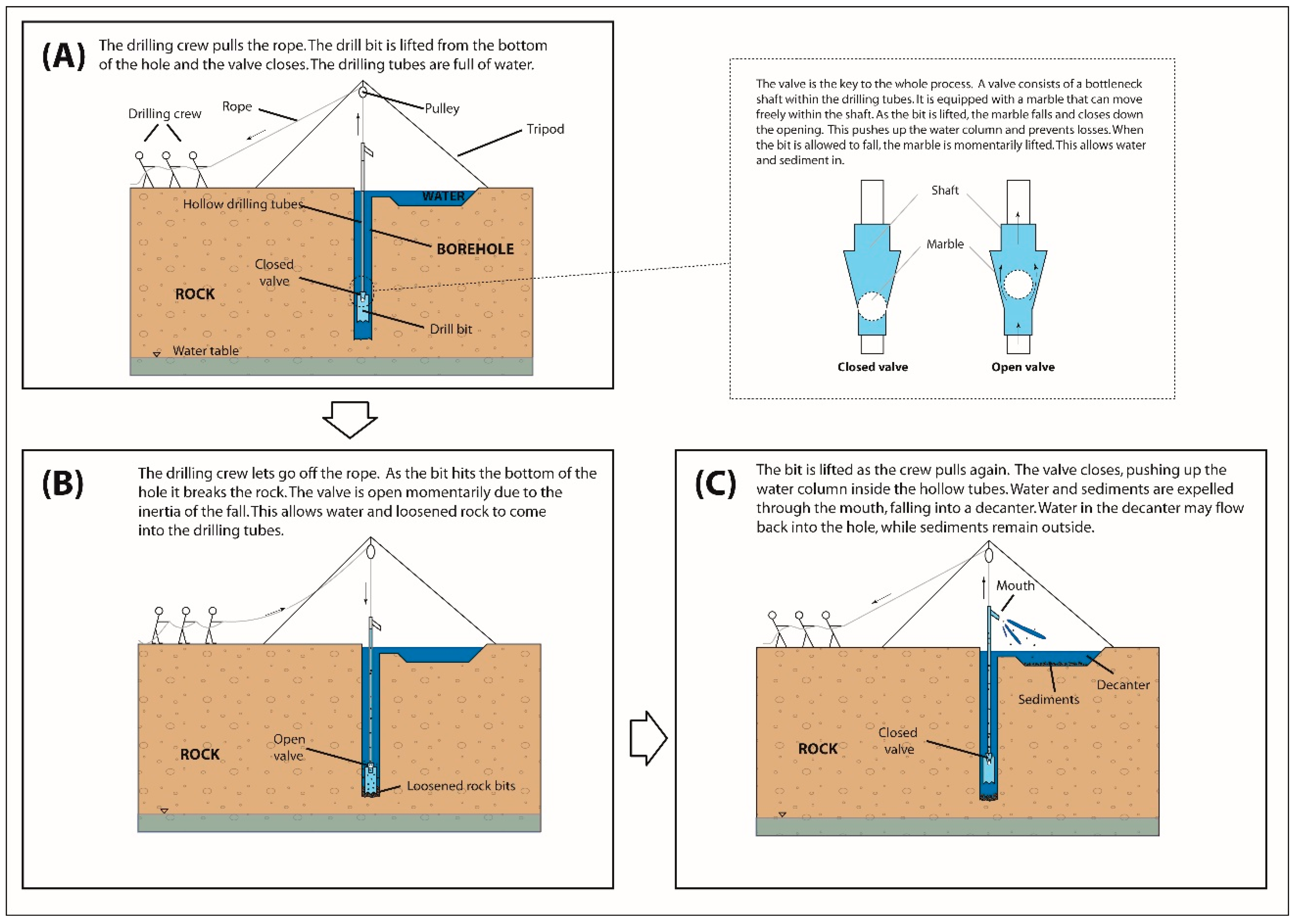
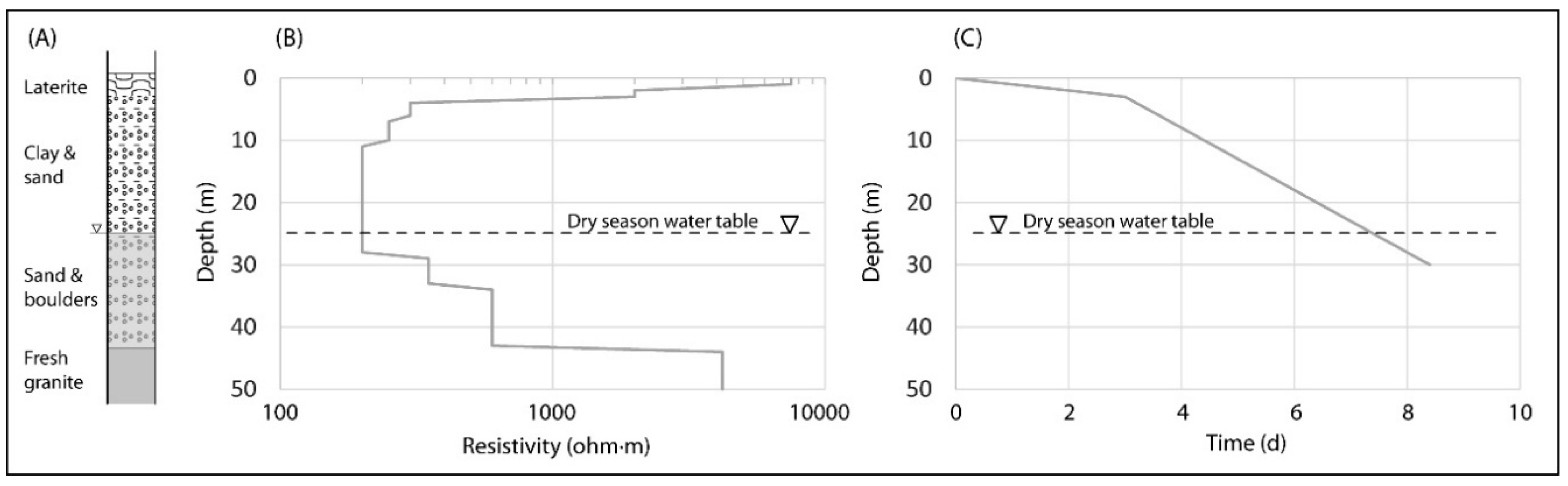
3.1. Description of the Manual Drilling Technique
3.2. Database Parameters and Field Survey
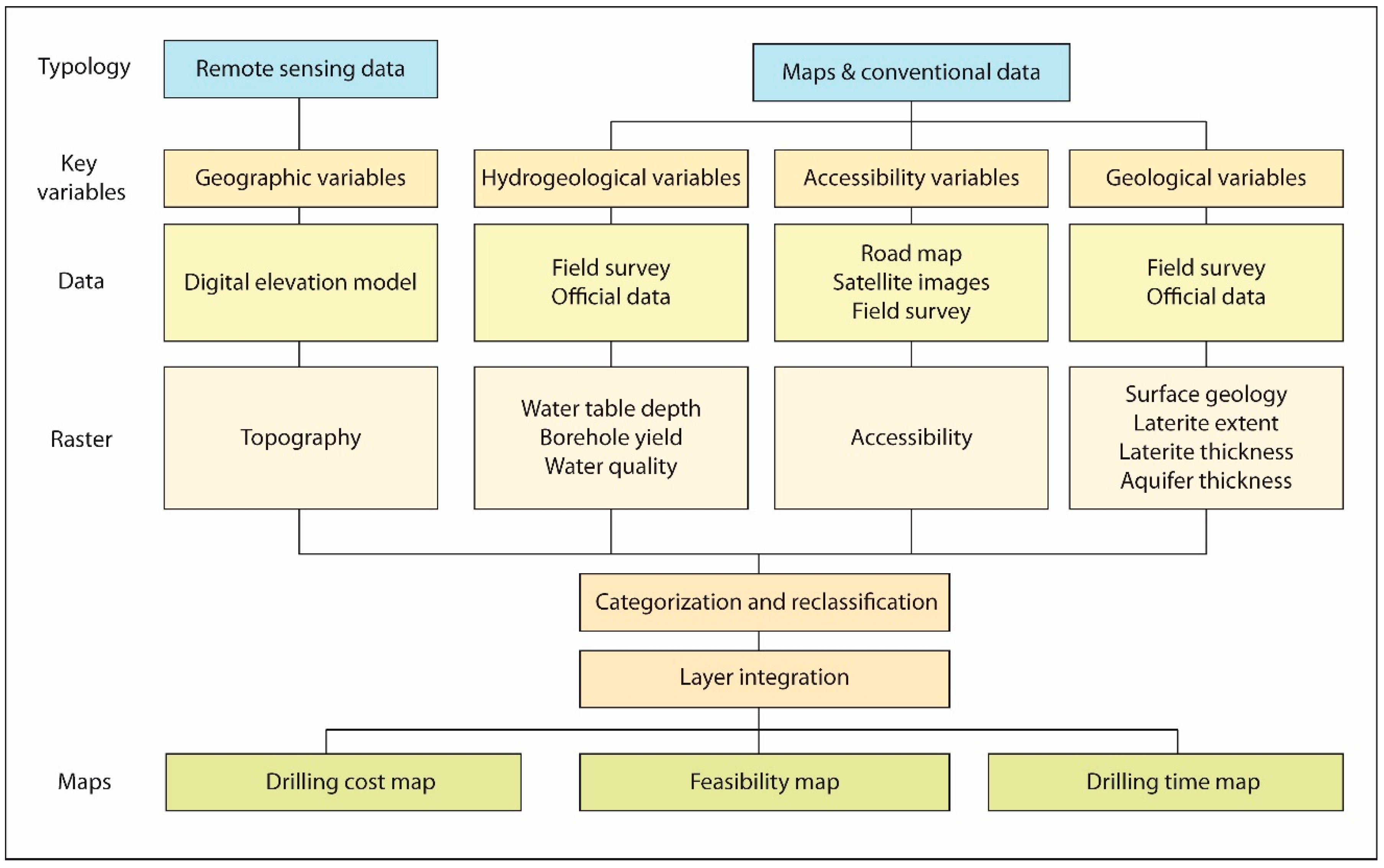
3.3. GIS Database Development
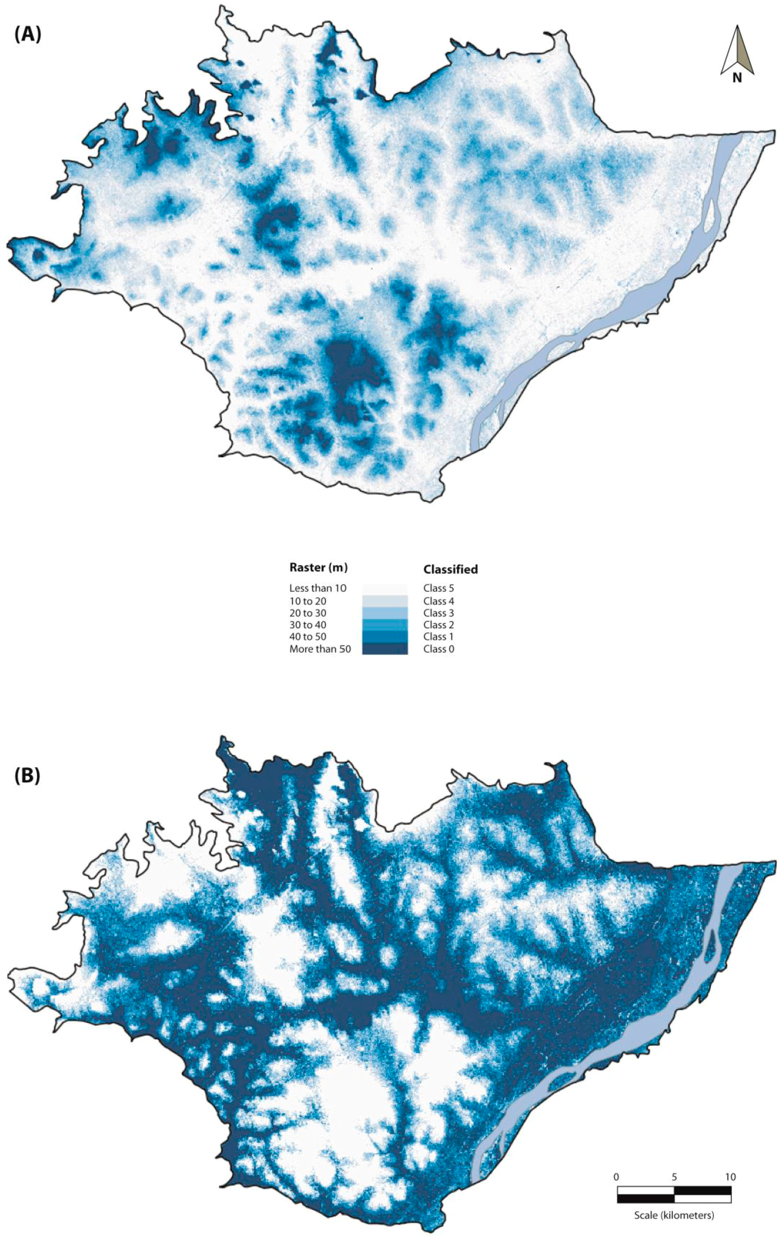
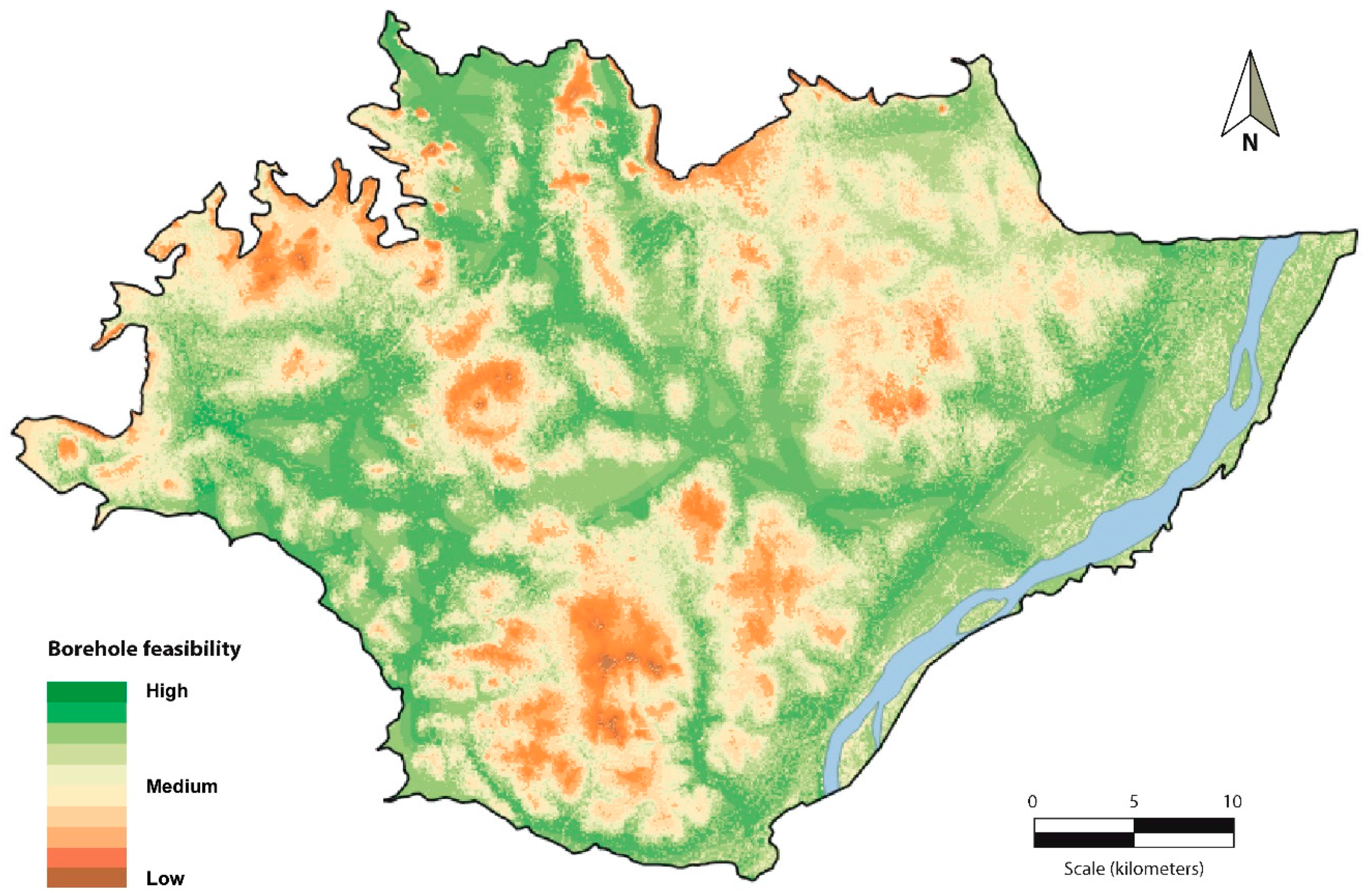
3.3.1. Feasibility Map
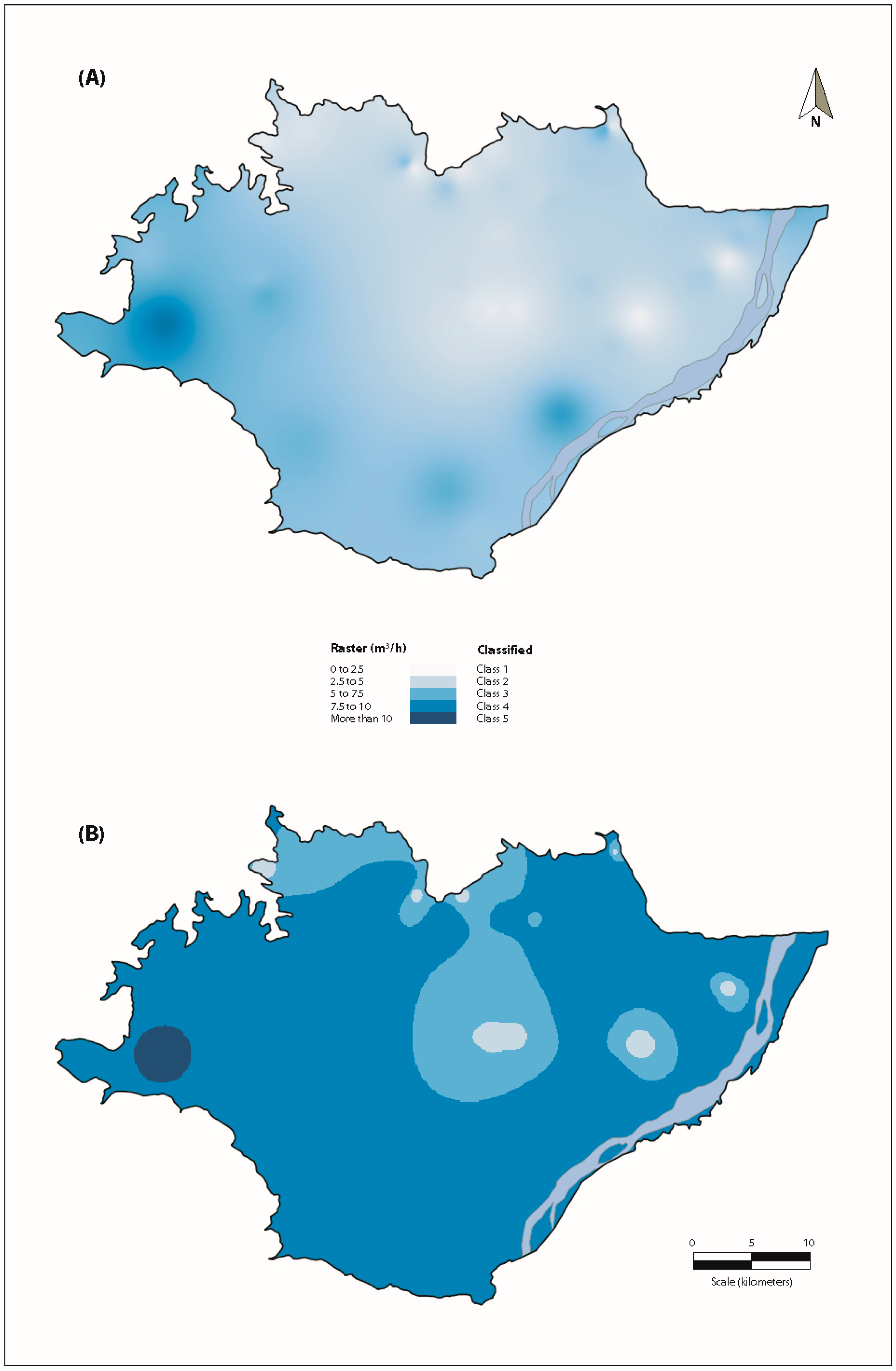
3.3.2. Time and Cost Maps
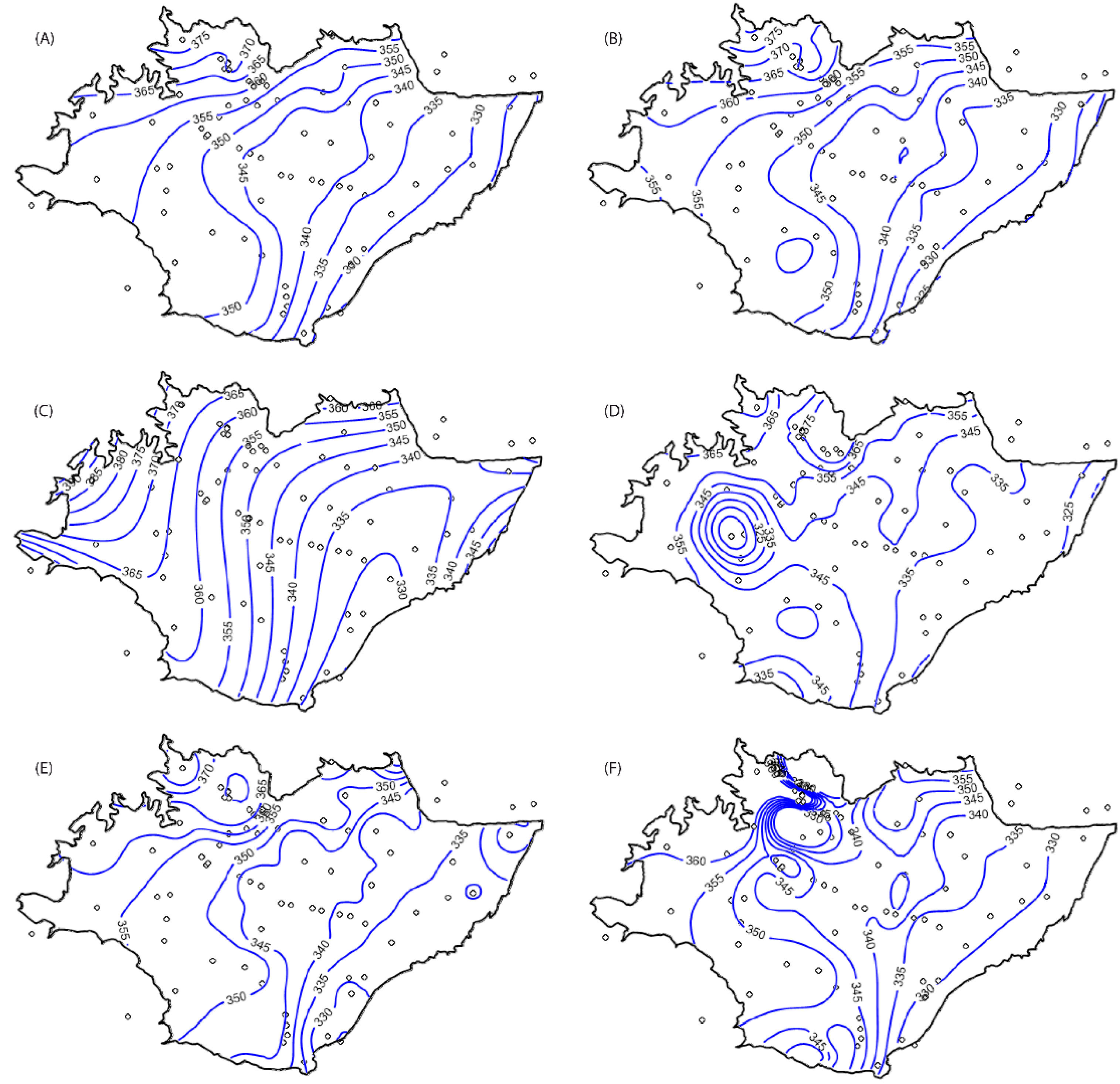
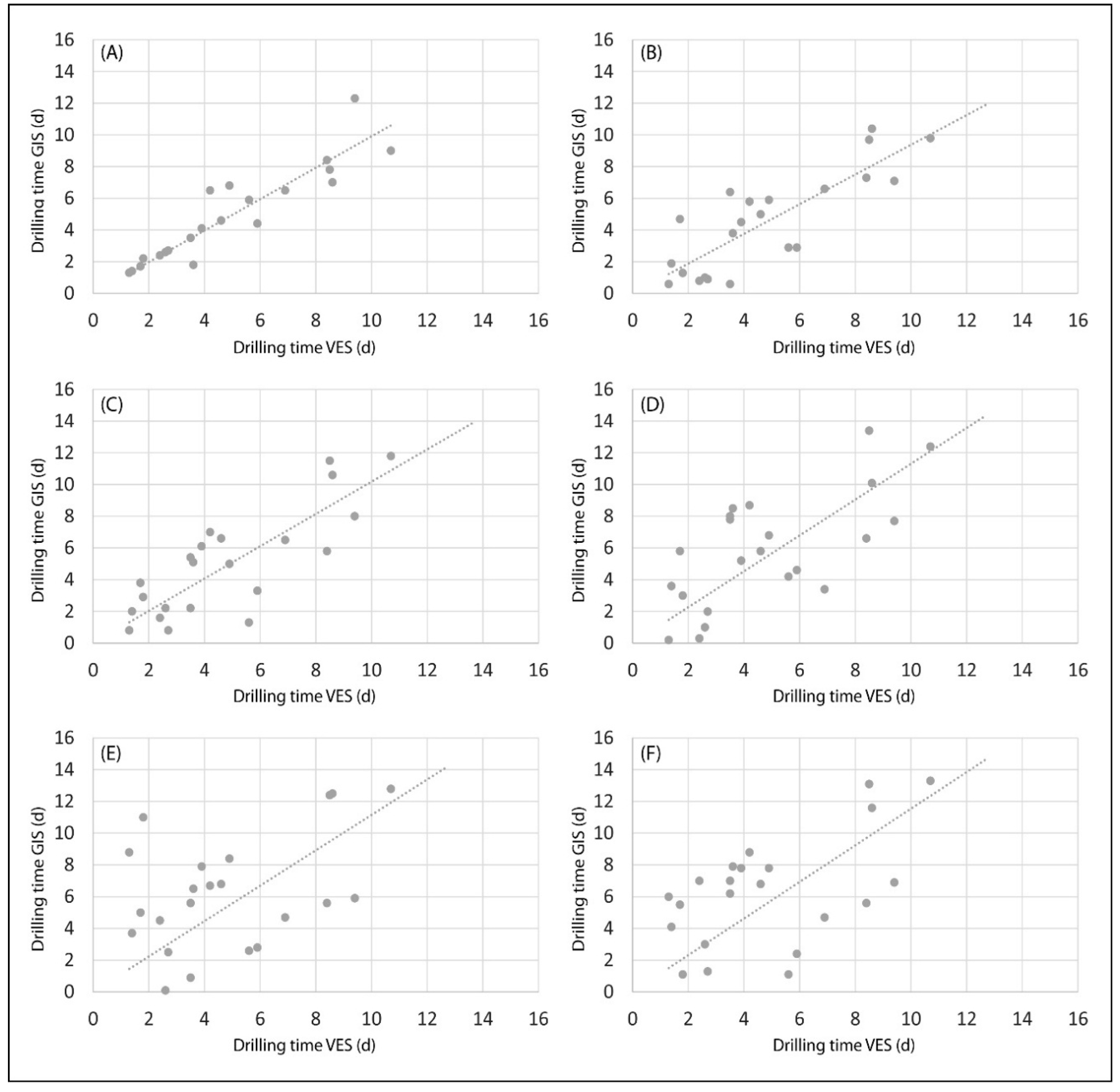
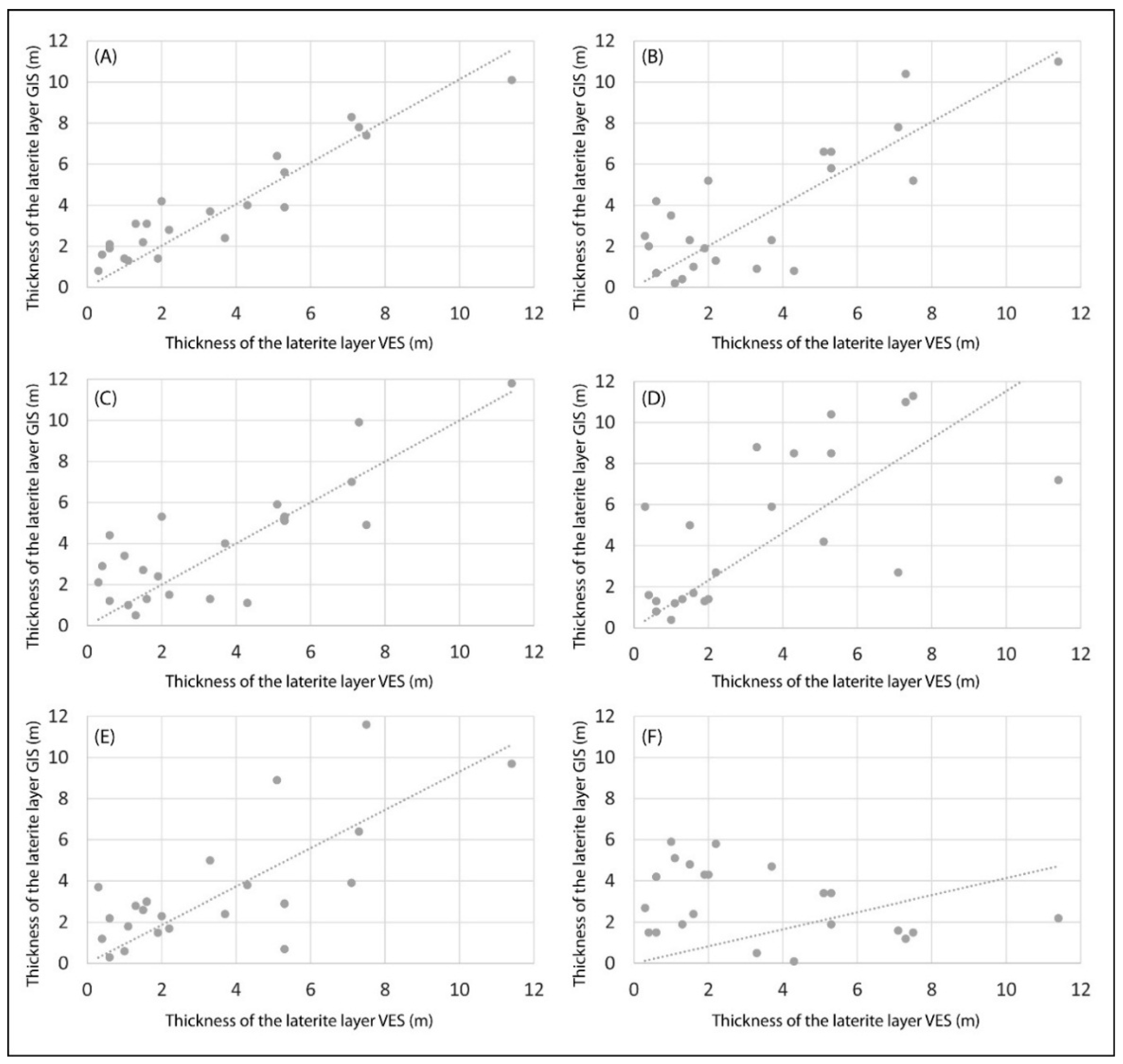
3.4. Data Interpolation Methods and Calibration Procedure
4. Results and Discussion
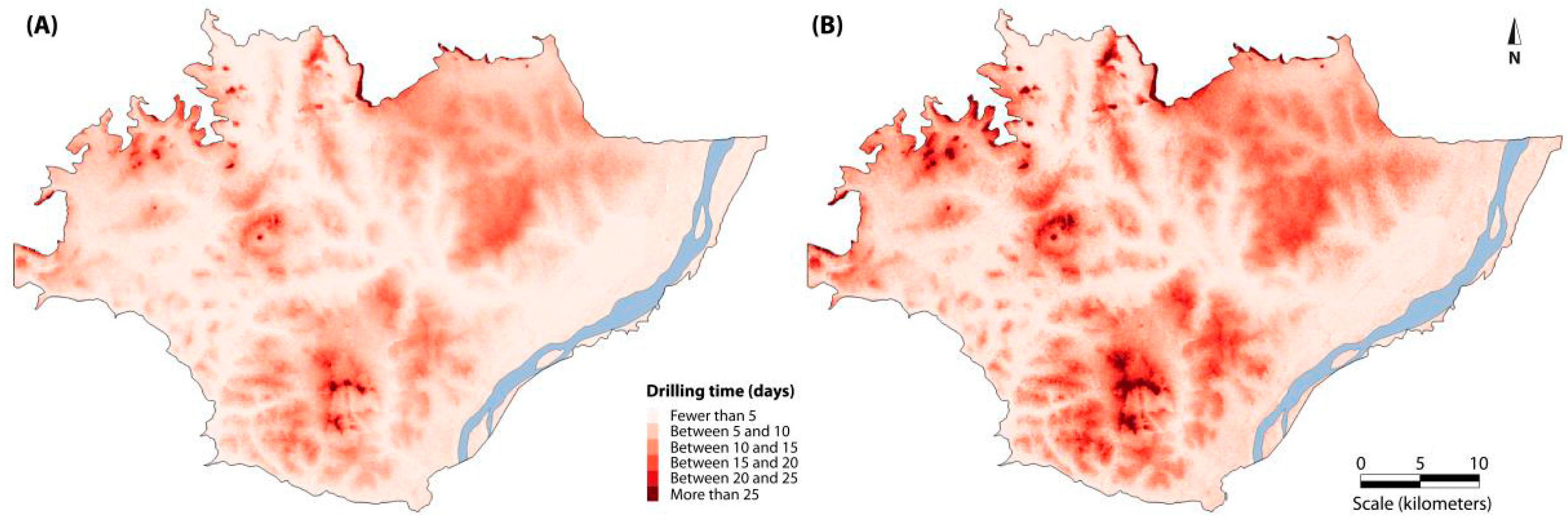
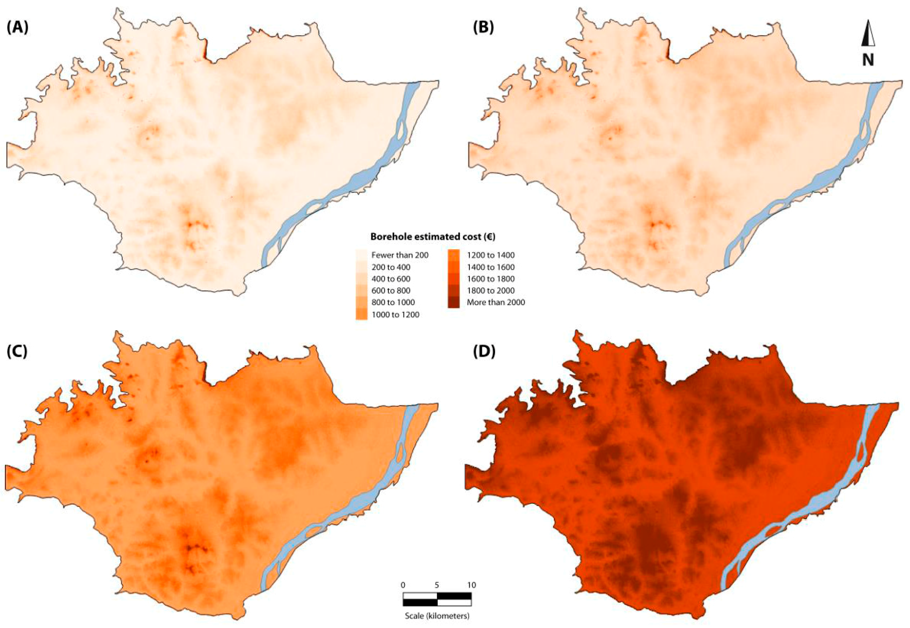
4.1. Drilling Feasibility, Time, and Cost Mapping
4.2. Map Resolution and Discussion in the Context of Methodological Precedents
5. Conclusions
Acknowledgments
Author Contributions
Conflicts of Interest
References
- Biswas, A.K. History of Hydrology; North-Holland Publishing Company: Amsterdam, The Netherlands; London, UK, 1970. [Google Scholar]
- UNICEF-WHO. Progress on Sanitation and Drinking Water—2015 Update and MDG Assessment; WHO Library Cataloguing-in-Publication Data; UNICEF and World Health Organization: New York, NY, USA, 2015. [Google Scholar]
- United Nations. The Right to Water. Fact Sheet No. 35; United Nations, OHCHR, UN-HABITAT, WHO: Geneva, Switzerland, 2010; p. 61. [Google Scholar]
- UNICEF-WHO. Drinking Water Equity, Safety and Sustainability: Thematic Report on Drinking Water 2011; UNICEF Joint Monitoring Programme for Water Supply and Sanitation; World Health Organization: New York, NY, USA, 2011; p. 62. [Google Scholar]
- Acharyya, A. Groundwater, climate change and sustainable wellbeing of the poor: Policy options for South Asia, China and Africa. Procedia Soc. Behav. Sci. 2014, 157, 226–235. [Google Scholar] [CrossRef]
- Llamas, M.R.; Martínez-Santos, P. Intensive groundwater use: Silent revolution and potential source of social conflict. ASCE J. Water Resour. Plan. Manag. 2005, 131, 337–341. [Google Scholar] [CrossRef]
- World Bank. Etude sur L’optimisation du Coût des Forages en Afrique de l’Ouest. Rapport de Synthèse; Rapport n° 44743/A; World Bank: Orléans, France, 2006; p. 50. [Google Scholar]
- VanderPost, C.; McFarlane, M. Groundwater investigation in semi-arid developing countries, using simple GIS tools to facilitate interdisciplinary decision making under poorly mapped conditions: The Boteti area of the Kalahari region in Botswana. Int. J. Appl. Earth Observ. Geoinf. 2007, 9, 343–359. [Google Scholar] [CrossRef]
- García-Rodríguez, M.; Antón, L.; Martínez-Santos, P. Estimating groundwater resources in remote desert environments by coupling geographic information systems with groundwater modeling (Erg Chebbi, Morocco). J. Arid Environ. 2014, 110, 19–29. [Google Scholar] [CrossRef]
- Danert, K. Manual Drilling Compendium 2015. Rural Water Supply Network. Sustainable Groundwater Development; Publication 2015-2; Skat: St. Gallen, Swirtzerland, 2015; p. 40. [Google Scholar]
- Wanke, H.; Nakwafila, A.; Hamutoko, J.T.; Lohe, C.; Neumbo, F.; Petrus, I.; David, A.; Beukes, H.; Masule, N.; Quinger, M. Hand dug wells in Namibia: An underestimated water source or a threat to human health? Phys. Chem. Earth Parts A/B/C 2014, 76–78, 104–113. [Google Scholar] [CrossRef]
- Danert, K. Realizing the Potential of Hand-Drilled Wells for Rural Water Supplies. Waterlines 2009, 28, 108–129. [Google Scholar] [CrossRef]
- Danert, K.; Carter, R.C.; Adekile, D.; MacDonald, A. Cost-effective boreholes in sub-Saharan Africa. In Proceedings of the 33rd WEDC International Conference, Accra, Ghana, 7–11 April 2008. [Google Scholar]
- Tapia Reed, D.A. Perforación Manual de Pozos Profundos Usando el Método EMAS-AYNI. Bachellor’s Thesis, Universidad Técnica Federico Santa María, Valparaiso, Chile, December 2008. 79p. [Google Scholar]
- Van der Wal, A. Understanding Groundwater & Wells; Technical Report; Practica Foundation: Papendrecht, The Netherlands, 2008; p. 49. [Google Scholar]
- Vuik, R.; de Koning, D.; van der Wal, A. Technical Training Handbook on Affordable Manual Well Drilling. Percussion. Manual Drilling Series; Technical Report; Practica Foundation: Papendrecht, The Netherlands, 2010; p. 64. [Google Scholar]
- UNICEF. Capitalisation D’experiences sur les Forages Manuels a Madagascar; Technical Report; Practica Foundation: Papendrecht, The Netherlands, 2012; p. 50. [Google Scholar]
- Toure, N.M.; Kane, A.; Noel, J.F.; Turmine, V.; Nedeff, V.; Lazar, G. Water-poverty relationships in the coastal town of Mbour (Senegal): Relevance of GIS for decision support. Int. J. Appl. Earth Observ. Geoinf. 2012, 14, 33–39. [Google Scholar] [CrossRef]
- Imran, M.; Stein, A.; Zurita-Milla, R. Investigating rural poverty and marginality in Burkina Faso using remote sensing-based products. Int. J. Appl. Earth Observ. Geoinf. 2014, 26, 322–334. [Google Scholar] [CrossRef]
- Lee, S.; Kim, Y.S.; Oh, H.J. Application of a weights-of-evidence method and GIS to regional groundwater productivity potential mapping. J. Environ. Manag. 2012, 96, 91–105. [Google Scholar] [CrossRef] [PubMed]
- Abdalla, F. Mapping of groundwater prospective zones using remote sensing and GIS techniques: A case study from the Central Eastern Desert, Egypt. J. Afr. Earth Sci. 2012, 70, 8–17. [Google Scholar] [CrossRef]
- Fashae, O.A.; Tijani, M.N.; Talabi, A.O.; Adedeji, O.I. Delineation of groundwater potential zones in the crystalline basement terrain of SW-Nigeria: An integrated GIS and remote sensing approach. Appl. Water Sci. 2014, 4, 19–38. [Google Scholar] [CrossRef]
- Sternberg, T.; Paillou, P. Mapping potential shallow groundwater in the Gobi Desert using remote sensing: Lake Ulaan Nuur. J. Arid Environ. 2015, 118, 21–27. [Google Scholar] [CrossRef]
- Rahmati, O.; Pourghasemi, H.R.; Melesse, A.M. Application of GIS-based data driven random forest and maximum entropy models for groundwater potential mapping: A case study at Mehran Region, Iran. CATENA 2016, 137, 360–372. [Google Scholar] [CrossRef]
- Yeh, H.F.; Cheng, Y.S.; Lin, H.I.; Lee, C.H. Mapping groundwater recharge potential zone using a GIS approach in Hualian River, Taiwan. Sustain. Environ. Res. 2016, 26, 33–43. [Google Scholar] [CrossRef]
- Raposo, J.R.; Molinero, J.; Dafonte, J. Parameterization and quantification of recharge in crystalline fractured bedrocks in Galicia-Costa (NW Spain). Hydrol. Earth Syst. Sci. 2012, 16, 1667–1683. [Google Scholar] [CrossRef]
- Yeh, H.F.; Lee, C.H.; Hsu, K.C.; Chang, P.H. GIS for the assessment of the groundwater recharge potential zone. Environ. Geol. 2009, 58, 185–195. [Google Scholar] [CrossRef]
- Rajasooriyar, L.D.; Boelee, E.; Prado, M.C.C.M.; Hiscock, K.M. Mapping the potential human health implications of groundwater pollution in southern Sri Lanka. Water Resour. Rural Dev. 2013, 1–2, 27–42. [Google Scholar] [CrossRef]
- Babiker, I.S.; Mohamed, M.M.A.; Hiyama, T.; Kato, K. A GIS-based DRASTIC model for assessing aquifer vulnerability in Kakamigahara Heights, Gifu Prefecture, central Japan. Sci. Total Environ. 2005, 345, 127–140. [Google Scholar] [CrossRef] [PubMed]
- Hernández-Espriú, A.; Reyna-Gutiérrez, J.A.; Sánchez-León, E.; Cabral-Cano, E.; Carrera-Hernández, J.; Martínez-Santos, P.; Falorni, G.; Colombo, D. DRASTIC-Sg Model, a new extension to the DRASTIC approach for mapping groundwater vulnerability in aquifers subject to differential land subsidence. Application to Mexico City. Hydrogeol. J. 2014, 22, 1–17. [Google Scholar] [CrossRef]
- Bowman, I. Well Drilling Methods. United States Geological Survey; Water Supply Paper 257; Department of the Interior: Washington, DC, USA, 1911; p. 134. [Google Scholar]
- Tolman, C.F. Ground Water; McGraw Hill: New York, NY, USA; London, UK, 1937; p. 593. [Google Scholar]
- Weight, E.; Yoder, R.; Keller, A. Manual Well Drilling Investment Opportunity in Ethiopia; IWMI Working Paper 155; International Water Management Institute (IWMI): Colombo, Sri Lanka, 2013; p. 25. [Google Scholar]
- Practica Foundation. Étude de Faisabilité des Forages Manuels—Mali; Practica Foundation: Papendrecht, The Netherlands, 2010; p. 26. [Google Scholar]
- Fussi, F. Mapping of suitable zones for manual drilling as a possible solution to increase access to drinking water in Africa. In Proceedings of the 6th Rural Water Supply Network Forum, Kampala, Uganda, 29 November–1 December 2011. [Google Scholar]
- Kane, C.H.; Fussi, F.; Diène, M.; Sarr, D. Feasibility Study of Boreholes Hand Drilling in Senegal—Identification of Potentially Favorable Areas. J. Water Resour. Prot. 2013, 5, 1219–1226. [Google Scholar] [CrossRef]
- Thomas, S.A. An Evaluation of Spatial Data and Analysis for Identifying Potentially Favorable Areas for Manual Well Drilling: Zinder Region of Niger. Master’s Thesis, University of Nevada, Reno, NV, USA, 2010. 177p. [Google Scholar]
- Thomas, S.A.; McGwire, K.C.; Lutz, A.; Kratt, C.; Trammell, E.J.; Thomas, J.M.; McKay, W.A. Geospatial and regression tree analysis to map groundwater depth for manual well drilling suitability in the Zinder region of Niger. J. Hydrol. 2012, 446, 35–47. [Google Scholar] [CrossRef]
- Elson, B.; Shaw, R. Technical Brief No. 43 Simple Drilling Methods. Waterlines 1995, 13, 15–18. [Google Scholar]
- Carter, R.C. Ten-Step Guide towards Cost-Effective Boreholes. Case Study of Drilling Costs in Ethiopia. Field Note RWSN/WSP. World Bank: Nairobi, Kenya, 2006. Available online: http://www.rural-water-supply.net/_ressources/documents/default/192.pdf (accessed on 15 January 2017).
- MacDonald, A.; Davies, J.; Calow, R.; Chilton, J. Developing Groundwater: A Guide for Rural Water Supply; Practical Action Publishing: Rugby, UK, 2005. [Google Scholar]
- Solera, D.; Cano, B. Cartografía de Zonas Susceptibles de Perforación Manual con el Método Baptista en los Acuíferos de Zócalo del Sector Siby-Bancoumana-Narena (sur de Mali). Posgrado de Especialización en Agua, Saneamiento e Higiene en Cooperación Internacional; Universidad de Alcalá de Henares: Alcalá de Henares, Spain, 2016; p. 31. [Google Scholar]
- Kochilakis, G.; Poursanidis, D.; Chrysoulakis, N.; Varella, V.; Kotroni, V.; Eftychidis, G.; Lagouvardos, K.; Papathanasiou, C.; Karavokyros, G.; Aivazoglou, M.; et al. A web based DSS for the management of floods and wildfires (FLIRE) in urban and periurban areas. Environ. Model. Softw. 2016, 86, 111–115. [Google Scholar] [CrossRef]
- Portoghese, I.; D’Agostino, D.; Giordano, R.; Scardigno, A.; Apollonio, C.; Vurro, M. An integrated modelling tool to evaluate the acceptability of irrigation constraint measures for groundwater protection. Environ. Model. Softw. 2013. [Google Scholar] [CrossRef]
- Giordano, R.; D’Agostino, D.; Apollonio, C.; Scardigno, A.; Pagano, A.; Portoghese, I.; Lamaddalena, N.; Piccinni, A.F.; Vurro, M. Evaluating acceptability of groundwater protection measures under different agricultural policies”. Agric. Water Manag. 2015. [Google Scholar] [CrossRef]
- Noonan-Wright, E.K.; Opperman, T.S.; Finney, A.M.; Zimmerman, G.; Seli, R.; Elenz, L.; Calkin, D.; Fiedler, J. Developing the US wildland fire decision support system. J. Combust. 2011, 14, 168473. [Google Scholar] [CrossRef]
- Kalabokidis, K.; Athanasisa, N.; Gagliardi, F.; Karayiannis, F.; Palaiologou, P.; Parastatidis, S.; Vasilakos, C. Virtual Fire: A web-based GIS platform for forest fire control. Ecol. Inf. 2013, 16, 62–69. [Google Scholar] [CrossRef]
- Li, X.; Ouelhadj, D.; Song, X.; Jones, D.; Wall, G.; Howell, K.W.; Igwe, P.; Martin, S.; Song, D.; Pertin, E. A decision support system for strategic maintenance planning in offshore wind farms. Renew. Energy 2016, 99, 784–799. [Google Scholar] [CrossRef]
- Gong, N.; Lempert, R.; Parker, A.; Mayer, L.A.; Fischbach, J.; Sisco, M.; Mao, Z.; Krantz, D.H.; Kunreuther, H. Testing the scenario hypothesis: An experimental comparison of scenarios and forecasts for decision support in a complex decision environment. Environ. Model. Softw. 2017, 91, 135–155. [Google Scholar] [CrossRef]
- Waller, T. The Agua Para Todos/Water for All International, “Baptist”, Low Well Drilling Technology; Technical Manual; Water for All International: Paint Rock, TX, USA, 2006; p. 49. [Google Scholar]
- Van Kinderen, I.; Vuik, R.; Pelgrim-Adams, A. From emergency to development or viceversa? Key lessons from the innovation of a well-drilling method. In Proceedings of the 38th International Conference, Water Sanitation and Hygiene Services Beyond 2015: Improving Access and Sustainability, Loughborough University, Loughborough, UK, 2015. [Google Scholar]
- Wright, E.P. The hydrogeology of crystalline basement aquifers in Africa. Geol. Soc. Spec. Publ. 1992, 66, 1–27. [Google Scholar] [CrossRef]
- Chilton, P.J.; Foster, S. Hydrogeological characterization and water-supply potential in basement aquifers in tropical Africa. Hydrogeol. J. 1995, 3, 36–49. [Google Scholar] [CrossRef]
- De la Ossa, L. Estudio Hidrogeológico del Acuífero del Zócalo Granítico Entre la Zona Alta del Río Níger y las Montañas Mandinga. Sur de Mali. Máster Profesional en Hidrología Subterránea. Fundación Centro Internacional de Hidrología Subterránea. Master’s Thesis, Universitat Politècnica de Catalunya, Barcelona, Spain, 2015. [Google Scholar]
- Foster, S.; Tuinhof, A.; Garduño, H. Groundwater Development in Sub-Saharan Africa Groundwater Development in Sub-Saharan Africa—A Strategic Overview of Key Issues and Major Needs. GW MATE Case Profile Collection; No. 15; World Bank: Washington, DC, USA, 2006. [Google Scholar]
- Robledano, A. Caracterización Hidrogeológica del Sector Acuífero Siby-Bankoumana-Niarela (República de Malí). Master’s Thesis, Universidad Complutense de Madrid, Madrid, Spain, 2016. [Google Scholar]
- Martínez-Santos, P.; De la Ossa, L.; Díaz-Alcaide, S.; Castaño-Castaño, S.; Rodríguez-Arevalo, J.; Pérez-Zabaleta, E.; Díaz-Teijeiro, M.F.; Miguel Martín-Loeches, M. Conceptual and mathematical models of the socle aquifer between the Plateau Mandingue and River Niger, southern Mali. In Proceedings of the 10th Alexander von Humboldt International Conference, Addis Ababa, Ethiopia, 18–20 November 2015. [Google Scholar]
- Traore, D.; Hui, Q. The Effects of Polluted River Water to the Riverside Groundwater, Case in Niger River in Koulikoro. Environ. Natl. Resour. Res. 2014, 4, 238–244. [Google Scholar] [CrossRef]
- WFA. Welcome to the Possibilities of Low Cost Water for the Poor. Water for All International Website. Available online: www.waterforallinternational.org (accessed on 29 October 2016).
- Sea, F.; Tanguay, M.G.; Trudel, P.; Perrault, G. Preliminary results of a study on gold dispersion in the laterite deposits of a gold zone in Misseni, Mali. Can. J. Earth Sci. 1990, 27, 1686–1698. [Google Scholar]
- BGS. Groundwater Quality: Mali. Water Aid Factsheets; British Geological Survey: London, UK, 2002; p. 5. [Google Scholar]
- Malato, S.; Blanco, J.; Alarcón, D.C.; Maldonado, M.I.; Fernández-Ibáñez, P.; Gernjak, W. Photocatalytic decontamination and disinfection of water with solar collectors. Catal. Today 2007, 122, 137–149. [Google Scholar] [CrossRef]
- Satyro, S.; Race, M.; Marotta, R.; Dezotti, M.; Spasiano, D.; Mancini, G.; Fabbricino, M. Simulated solar photocatalytic processes for the simultaneous removal of EDDS, Cu(II), Fe(III) and Zn(II) in synthetic and real contaminated soil washing solutions. J. Environ. Chem. Eng. 2014, 2, 1969–1979. [Google Scholar] [CrossRef]
- DNH. Synthèse Hydrogéologique du Mali, Exploitation, Évaluation et Gestion des Ressources en eau Souterraine. Direction Nationale de l’Hydraulique; Ministère de l’Environnement, de l’Eau et de l’Assainissement: Bamako, Mali, 1990.
- DNH. Données Hydrogeologiques et des Forages. Direction Nationale de l’Hydraulique; Ministère de l’Environnement, de l’Eau et de l’Assainissement: Bamako, Mali, 2010.
- USGS. EarthExplorer. Help Documentation, Version 2.0; United States Geological Survey: Reston, VA, USA, 2013; p. 73.
- MDI. Carte Photogéologique du Mali Occidental au 1/200000, Bamako-Ouest; Direction Nationale de la Géologie et des Mines, Ministère du Développement Industriel: Bamako, Mali, 1986.
- Agencia Española de Cooperación Internacional al Desarrollo (AECID). Experiencias de Perforación Manual Para el Abaratamiento del Acceso al Agua en la República de Mali; Technical Report; AECID: Madrid, Spain, 2017. [Google Scholar]
- MacDonald, A.M.; Davies, J. A Brief Review of Groundwater for Rural Water Supply in Sub-Saharan Africa; BGS/DFID Technical Report, WC/00/33; BGS: Nottingham, UK, 2000. [Google Scholar]


| Category | Term | Definition |
|---|---|---|
| Wells and boreholes | Borehole | A narrow shaft bored in the ground for the purpose of extracting groundwater. Boreholes are cased, gravel packed and equipped with a pump and wellhead protection. |
| Manual borehole | A borehole drilled by manual means, replicating the work of a mechanical rig by hand. Typically less than 50–60 m deep, with a casing diameter of two to four inches. Drilling methods include augering, percussion, sludging and jetting. | |
| Mechanized borehole | A borehole drilled by means of a mechanical rig, usually mounted on a truck. May be hundreds of meters deep. Casing diameter usually measured in inches. Mechanized boreholes are comparatively more expensive than manual boreholes. | |
| Excavated well, dug well, well | A large diameter (typically >0.5 m) hole in the ground used for the purpose of extracting groundwater. Typically dug using peaks and shovels. Generally less than 25 m deep. | |
| Pumps | Standard pump | A commercially-available pump used to extract groundwater from within a borehole. Most standard pumps in the study area require four-inch casing diameters. Yields can be highly variable, depending on the type of pump. |
| Hand pump | A sub-type of standard pump. Commercially-available and powered by hand. If the aquifer is sufficiently transmissive, yields are limited by the pumping capacity of a human being (which typically ranges between 0.5 and 1.5 m3/h). | |
| Powered pump | The other sub-type of standard pump. Commercially-available pump powered by electricity or gasoil. If the aquifer is sufficiently transmissive, yields may greatly exceed those from hand and homemade pumps (typically several cubic meters per hour in the study area). | |
| Homemade pump, locally-made pump | A non-standard hand pump. Made with inexpensive local materials and powered by human action. Typically less durable than a standard pump, but also easier and cheaper to fix. Yields do not often exceed 1 m3/h. |
| Category | Data | Description | Source | Year |
|---|---|---|---|---|
| Topography | Topography map | Map ND29-15. Series G504. Bamako. Scale 1:250,000 | US Army Corps of Engineers | 1955 |
| Digital Elevation Model | Obtained from the EarthExplorer website, pixel resolution 30 m × 30 m (www.earthexplorer.usgs.gov) | United States Geological Survey | 2013 | |
| Surface geology | Spatial distribution of geological formations at the surface | Obtained from the “Carte photogéologique du Mali Occidental. Bamako-Ouest” Scale 1:200,000 | Direction Nationale de la Géologie et des Mines, Mali | 1986 |
| Subsurface geology | Geological logs | Thirty-seven borehole logs were made available on demand by different sources. The thickness of the laterite layer was measured directly in 31 large diameter wells. Twenty-two geophysical profiles were gathered after fieldwork for the purpose of calibrating the results of the database. | Direction Nationale de l’Hydraulique, Mali. Private contractors. Geologists Without Borders. Fieldwork | Various |
| Groundwater | Water table depth | Water table depth sampled in 71 wells towards the end of the dry season (most unfavorable conditions). | Fieldwork | 2015/2016 |
| Surface water | Main, secondary rivers, and water bodies | Obtained from the Humanitarian Data Exchange website. Scale 1:1,000,000 (www.data.humdata.org) | Office for the Coordination of Humanitarian Affairs, Mali | 2015 |
| Accessibility | Road and trail network | Traced from satellite imaging and checked during field survey. | Google Earth | 2016 |
| Drilling cost | Wages, cost of drilling, and pumping equipment | Obtained from direct experience, drilling 20 manual boreholes in nearby geologically similar areas. | Fieldwork | 2015/2016 |
| Drilling time | Drilling times | Obtained from direct experience, drilling 20 manual boreholes in nearby geologically similar areas. | Fieldwork | 2015/2016 |
| Layer | Range | Unit | Class | Obtained from |
|---|---|---|---|---|
| Landforms (proximity), L | Absent | (.) | 1 | Topography, geology, water table depth |
| Present | 0 | |||
| Geology (laterite thickness), G | 0 to 2 | m | 5 | Field survey, geological map, topography |
| 2 to 4 | 4 | |||
| 4 to 6 | 3 | |||
| 6 to 8 | 2 | |||
| 8 to 50 | 1 | |||
| >50 | 0 | |||
| Water table depth, P | <5 | m | 5 | Topography, field survey |
| 5 to 10 | 4 | |||
| 10 to 15 | 3 | |||
| 15 to 20 | 2 | |||
| 20 to 25 | 1 | |||
| >25 | 0 | |||
| Accessibility, A | 0 to 500 | m | 3 | Road network, satellite imaging, field survey |
| 500 to 1000 | 2 | |||
| >1000 | 1 | |||
| Well yield, Y | >7 | m3/d | 5 | Official data |
| 3 to 7 | 4 | |||
| 2 to 3 | 3 | |||
| 1 to 2 | 2 | |||
| <1 | 1 | |||
| Water quality, Q | <1000 | µS/cm | 2 | Official data, field survey |
| 1000 to 2000 | 1 | |||
| >2000 | 0 |
| Variable | Method | Mean Residual | Standard Deviation | Standard Error | RMS |
|---|---|---|---|---|---|
| Water table level (m a.s.l) | Kriging | 0.04 | 3.25 | 0.43 | 3.24 |
| Minimum Curvature | −0.34 | 4.24 | 0.56 | 4.21 | |
| Radial Basis Function | −0.36 | 6.74 | 0.89 | 6.69 | |
| Inverse Distance to Power | −0.62 | 6.67 | 0.88 | 6.65 | |
| Modified Shephard | 0.09 | 4.81 | 0.63 | 4.78 | |
| Polynomial Regression | 7.26 | 7.78 | 1.02 | 7.71 |
| Statistic | OK | MC | RBF | MSM | IDP | PR |
|---|---|---|---|---|---|---|
| Pearson R2 | 0.89 | 0.83 | 0.80 | 0.67 | 0.53 | 0.41 |
| Mean absolute error (d) | 0.76 | 1.45 | 1.71 | 2.47 | 3.14 | 3.29 |
| Mean StDev (d) | 1.01 | 1.06 | 1.03 | 2.42 | 1.25 | 1.85 |
| Max Error (d) | 2.96 | 3.30 | 4.81 | 5.99 | 4.74 | 9.01 |
| Min Error (d) | 0.03 | 0.15 | 0.36 | 0.70 | 0.40 | 0.29 |
© 2017 by the authors. Licensee MDPI, Basel, Switzerland. This article is an open access article distributed under the terms and conditions of the Creative Commons Attribution (CC BY) license (http://creativecommons.org/licenses/by/4.0/).
Share and Cite
Martínez-Santos, P.; Martín-Loeches, M.; Solera, D.; Cano, B.; Díaz-Alcaide, S. Mapping the Viability, Time, and Cost of Manual Borehole Drilling in Developing Regions. Water 2017, 9, 262. https://doi.org/10.3390/w9040262
Martínez-Santos P, Martín-Loeches M, Solera D, Cano B, Díaz-Alcaide S. Mapping the Viability, Time, and Cost of Manual Borehole Drilling in Developing Regions. Water. 2017; 9(4):262. https://doi.org/10.3390/w9040262
Chicago/Turabian StyleMartínez-Santos, Pedro, Miguel Martín-Loeches, Daniel Solera, Beatriz Cano, and Silvia Díaz-Alcaide. 2017. "Mapping the Viability, Time, and Cost of Manual Borehole Drilling in Developing Regions" Water 9, no. 4: 262. https://doi.org/10.3390/w9040262
APA StyleMartínez-Santos, P., Martín-Loeches, M., Solera, D., Cano, B., & Díaz-Alcaide, S. (2017). Mapping the Viability, Time, and Cost of Manual Borehole Drilling in Developing Regions. Water, 9(4), 262. https://doi.org/10.3390/w9040262