Article

Restoring Summer Base Flow under a Decentralized Water Management Regime: Constraints, Opportunities, and Outcomes in Mediterranean-Climate California

1
Soil and Water Sciences Department, University of Florida, IFAS West Florida Research and Education Center, Milton, FL 32583, USA
2
Occidental Arts and Ecology Center WATER Institute, Occidental, CA 95465, USA
*
Author to whom correspondence should be addressed.
Water 2017, 9(1), 29; https://doi.org/10.3390/w9010029
Submission received: 1 November 2016 / Revised: 14 December 2016 / Accepted: 21 December 2016 / Published: 6 January 2017

Abstract

:
Seasonal rainfall dynamics in Mediterranean-climate coastal California place pressures on humans and aquatic ecosystems. Without rainfall during summer, residents and land managers commonly turn to streams and adjacent shallow aquifers to meet domestic, irrigation, and recreational water needs, often depleting the water necessary to support stream biota. The potential for adverse ecological impacts within this coupled natural-human system has led to interest in restoring summer base flow (especially for federally protected steelhead and coho salmon, which depend on flow through the summer dry season for juvenile survival) through methods such as reducing dry-season water abstractions. Characterizing constraints and opportunities has proven useful for planning streamflow restoration in Mediterranean-climate coastal California. Biophysical parameters such as ample rainfall and very low summer discharge are critical considerations, but institutional parameters are equally important: regional management practices and state laws can inhibit streamflow restoration, and implementation is dependent on interrelationships among residents, agency staff, and other stakeholders (which we term the egosystem) within each watershed. Additionally, while watershed-scale spatial analysis and field-based evaluations provided a solid foundation for exploring streamflow restoration needs, adaptation based on information from local stakeholders was often essential for prioritizing projects and understanding whether projects will have their intended benefits.

1. Introduction

In Mediterranean-climate coastal California, sustaining adequate summer base flow has been recognized as a key factor for maintaining aquatic organisms and ecosystem services [1,2]. The seasonality of precipitation, manifested almost entirely as rainfall during the rainy winter season, results in base flow that steadily recedes through spring and summer and often reaches intermittence. While the flow regime of a handful of major rivers in coastal Mediterranean California are controlled by large reservoirs, this recession trend is a characteristic feature of non-regulated streams in this region ranging from first-order headwater streams to seventh-order rivers [3,4]. These climatic variations can have detrimental impacts on aquatic communities [5,6]; but they also result in high biodiversity [7,8]. Organisms native to this region, in particular steelhead and coho salmon (Oncorhynchus mykiss and O. kisutch, respectively), have adapted their life history to this variation [9]. After adult salmonids swim from the ocean to freshwater streams in winter to spawn, juvenile fish emerge from redds in spring and spend one summer in freshwater streams before smolting and migrating to the ocean (steelhead often spend more than one year in freshwater streams before smolting). An adequate supply of cool water through the dry season is essential to maintain food supply, cool water temperatures, and other biochemical standards (e.g., nutrient concentrations, dissolved oxygen) until rain resumes again in late fall [10].
The need for summer base flow to sustain juvenile salmonids through the dry season represents a precariously balanced coupled natural-human system in Mediterranean coastal California [11]. The low summer base flow also places harsh pressures on humans living in the area: many of the region’s valleys receive ample rainfall to support its residential, recreational, and agricultural development on an annual scale (e.g., ranging from 600 to over 1000 mm in an average year), but the seasonality of rainfall necessitates water resource planning through the growing season. Agricultural and residential development over the majority of the region is not served by large water providers; rather, agricultural producers and rural residents obtain water individually to meet their needs. Groundwater is often of poor quality and low abundance in the Franciscan-type bedrock that underlies much of coastal California [12], so residents and land managers rely on surface streams and shallow alluvial aquifers beside streams to meet dry-season water needs [13].
Abstractions from freshwater streams can be a major factor limiting the persistence of dry-season streamflow, and thus the survival of steelhead and coho salmon, in Mediterranean California [14]. Instream abstractions can cease flow locally over periods ranging from hours to days, and their impacts can propagate downstream to affect long sections of channel that provide habitat for salmonids through the dry season [15]. For the past seven years, conservation groups have worked collaboratively with landowners and managers to change the ways in which water is managed to improve dry season streamflow, particularly to benefit salmonids. The primary approach for reducing summer abstraction has been the construction of surface reservoirs or large tanks that can be filled in winter, when water is abundant, for use later in summer; alternatively, conservation approaches aim to reduce the overall need for water in the dry season (thereby reducing the amount that needs to be diverted and stored). In working to restore a sustainable streamflow regime, we have identified many constraints that challenge conservation objectives, as well as opportunities that facilitate them. Many of these, including laws and policies governing water, are specific to California (and even to the north-central coastal region); while others, such as the influence of drought and social perceptions of regulatory agencies, are widely applicable to the field of restoration. In this paper, we describe the constraints and the opportunities that have arisen as our partnership of conservation-oriented non-governmental organizations working in non-regulatory collaborative partnerships with resource agencies and local stakeholders have worked to restore base flow in Mediterranean-climate coastal California; and we share the initial outcomes of streamflow restoration actions in three watersheds in the region.

2. Defining Constraints and Opportunities

Constraints and opportunities can help to define a conceptual framework for restoration planning [16]. Through the restoration process of identifying a problem, conducting assessments of possible causes, proposing treatments, and evaluating effects of implementation [17] (discussed in more detail below), constraints and opportunities contextualize the regional dynamics of human and natural systems relative to restoration objectives [18]. Opportunities describe resources and tools that can be utilized to achieve restoration outcomes (e.g., resources available for offsetting or mitigating impacts; analytical tools to propose and evaluate restoration actions; implementation funding). Constraints identify the limitations and uncertainties of the mechanisms that can be used to achieve restoration outcomes (e.g., limits of resource availability imposed by climate; the accuracy of data describing impaired conditions and possible sources of impairment). They also can help to identify potential conflicts that may arise through the restoration planning and implementation process (e.g., by including steps that address conflict between regulatory policies and restoration objectives).
In working to restore summer base flow in tributaries to the Russian River watershed in coastal California, we have identified constraints that must be overcome to achieve our restoration objectives, as well as opportunities provided by natural and social/institutional frameworks that can be utilized to achieve our objectives. The Russian River, which drains approximately 3900 square km and enters the Pacific Ocean 85 km north of San Francisco Bay, is the largest drainage basin within the Central Coastal California Coho Salmon Evolutionarily Significant Unit. The climate of the Russian River watershed is characteristically Mediterranean, with cool wet winters and warm dry summers. Much of the area is mountainous and forested; several valleys and some hillsides are utilized for agriculture (primarily for wine grapes). Many of its tributaries, with catchments ranging from 10 to 100 square km, provide critical habitat for these federally endangered salmonids as well as for federally threatened steelhead trout [2]. Within tributaries such as Dutch Bill Creek, Grape Creek, and Mill Creek, development has occurred throughout each watershed but tends to be most concentrated along streams (especially for residential development).

2.1. Constraints

Several constraints have emerged in working to restore adequate dry-season base flow in coastal California. Many address physical or biological limitations and uncertainties primarily driven by the Mediterranean climate; others pertain to social, institutional, and policy constraints.

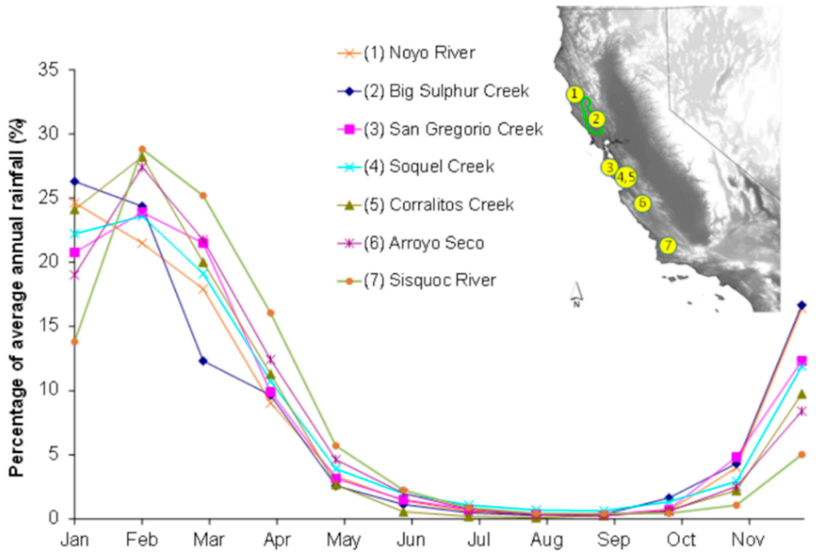
2.1.1. Climatic Effects: Low Summer Rainfall and Inter-Annual Variability

Low summer rainfall and base flow associated with the region’s Mediterranean climate present a challenge to maintaining adequate flow for salmonids through the dry season, even in watersheds with no upstream abstractions or human water demands. Low flow and intermittence create harsh physical and biochemical conditions for aquatic biota in Mediterranean climate streams [5]; juvenile salmonids must survive in streams through the summer dry season until rain begins again in fall. Historical US Geological Survey (USGS) streamflow records indicate that combined the discharge during the months of July, August, and September is typically 1 to 3 percent of the average annual discharge (Figure 1), mirroring general precipitation trends for the region [19]. Surface abstractions can exacerbate these harsh conditions: the magnitude of abstraction for irrigation of small recreational or agricultural fields (e.g., 2 to 10 L per second, or 30 to 160 gallons per minute) is often of similar magnitude as streamflow through the dry season in headwater (e.g., second- and third-order) streams, and flow can cease for as long as water is diverted [15].
Inter-annual precipitation variability is higher in coastal California than other places with similar average annual rainfall [20]; high variability from one year to the next translates to a greater magnitude of extremes, both in terms of flooding and of drought. It also can manifest as increased duration of extreme conditions [21]. Salmonid habitat is less, and recedes more quickly, in summers that follow drier-than-average winters than those that follow normal-type winters [22]. During very dry years, it may not be possible to distinguish between impacts to flow caused by abstractions from those caused by drought because streamflow is already very low as a result of low antecedent rainfall. In water resource management, planning for droughts is especially important because droughts define the lower limits of resource availability to which managers must adapt [23]. For restoration projects to maintain benefit for landowners over the long term, they must either be designed for the very extreme conditions of availability, or acknowledge the limits over which the project can offer the designed restoration benefits.

2.1.2. Decentralized Water Management

People have occupied and developed land for in coastal California for thousands of years. Fire management practiced by indigenous populations in the region to control vegetation likely had substantial effects on water resources, especially on summer base flow [24]. Since the settlement of modern California in the 19th Century, few large-scale water providers have been formed; as a result, water management over most of the region is decentralized, whereby people manage water individually to meet their various needs. Relatively small needs for water are met at individual users’ scale; abstractions are distributed across the drainage network [25], rather than at one location as would occur at a large, centrally managed water supply reservoir. Because small abstractions may be of similar magnitude as streamflow during summer and are distributed through the region, they can cause substantial individual or cumulative effects during periods when streamflow is low.
Decentralized water management may have the benefit of distributing impacts over space, thus not causing large impacts in particular parts of the drainage network; but in cases where development is concentrated, cumulative impacts may be appreciable. The distributed nature of development—and thus water needs—and the large variation in rates of abstraction complicate any determination of where human water demands have the greatest impacts to streamflow (and thus where restoration of streamflow would be most useful). Thus, the decentralized water management regime in coastal California constrains successful flow restoration by obfuscating the ability to identify the most acute sources of impact. Further, because of the large number of landowners who may obtain water from the stream, participation and buy-in among a large number of landowners is necessary to maintain streamflow benefits (especially so downstream neighbors do not take advantage of a newfound water supply).

2.1.3. California’s Dual Water Rights System

Policies governing water management in Mediterranean climate regions are often complicated by the defining seasonal dynamics [26]. California’s water rights system, and administration of that system, pose a major constraint for restoring base flow in coastal streams. California’s water rights system incorporates two main types of water rights: riparian and appropriative rights. An appropriative right is obtained by securing a permit, license, or registration from the State Water Board and putting the water to beneficial use [27]. It can be obtained by anyone, anywhere (so long as an applicant can demonstrate that water is available for appropriation and can put it to beneficial use), and is not linked to land ownership [28]. Riparian rights are inherent to ownership of land adjacent to streams; the abstraction of water under a riparian right does not require permission from the State Water Resources Control Board (State Water Board) [29]. Riparian rights do not allow for the storage of water in the wet season for use during the dry season; storage is only allowed under appropriative water rights. Riparian rights are senior in priority to appropriative rights. State Water Board records indicate that most coastal watersheds have users that divert under both bases of right [30].
This system creates disincentives for water management that is compatible with supporting salmonids. The easiest way for a streamside landowner to obtain water is to exercise his or her existing riparian right; and because riparian rights do not allow a water right holder to store water across seasons, abstractions under riparian right must occur during the dry season when water is needed. Storing water across seasons (i.e., storing water in winter for use in summer) requires an appropriative right, which requires permission granted from the state (and also places the user under a schedule of prioritization as required under the appropriative doctrine) [29]. Adding tank or pond storage can have advantages for the stream and the water user by developing a more reliable water supply (one that is not dependent on summer streamflow or groundwater availability), but they must outweigh the disadvantages associated with appropriative water rights and paying associated fees.
Moreover, the administration of water rights (or lack thereof) in coastal streams can make it even more difficult for conservation organizations and resource agency staff to identify how water is being used and prioritize efforts. For example, until recently the penalties for non-reporting for riparian rights were minimal [31]; so although riparian users are required to report their use to the state, many have not. There are also many abstractions that are not accounted for among water use records, including those for illicit water uses (e.g., marijuana cultivation) and abstractions from hydrologically-connected shallow aquifers (which frequently does not require a water right). This difference between water rights documentation on paper and in reality represents a major challenge to understanding how abstractions affect stream ecosystems, especially during the dry summer season.

2.1.4. Land Ownership Characteristics

The overwhelming majority of the Russian River watershed is under private ownership, necessitating partnerships with private landowners to accomplish restoration projects. Funding is often available to implement streamflow restoration projects, but project implementation requires interest among landowners and a willingness to have activities (and associated regulatory scrutiny) conducted on their properties. Cooperative partnerships with competent partners are especially important for streamflow restoration: landowners often cite grave concerns about regulatory oversight of water use and potential loss of livelihood and land value that could be incurred by inviting regulators and the general public to scrutinize project plans for water storage, even if it would increase their personal water supply security and benefit oversummering salmonids. Surface water abstractions for agricultural, residential, and recreational uses all are possible sources of streamflow impairment, so partnerships must have the capacity to address a wide range of landowners and land managers. Property values are also very high in Sonoma County, with premium vineyard land valued as high as $120,000 United States Dollars (USD) per acre [32]; because of the high cost of land, new vineyard owners need to maximize revenue and converting land from vineyard to a reservoir may not be financially prudent.

2.1.5. Institutional Fragmentation

Several agencies assume regulatory authority over water resources in the Russian River watershed; their regulations are often poorly coordinated and disjointed [33]. The State Water Board oversees the appropriation of surface water throughout the state, and has developed guidelines for maintaining adequate streamflow for salmonids in northern California [1]. The National Marine Fisheries Service (NMFS) and California Department of Fish and Wildlife (CDFW) regulate the management of water resources as they pertain to protecting endangered coho salmon and steelhead trout; CDFW in particular has developed its own set of regulatory standards for ensuring water abstractions operate in a way that will protect salmonids (which offer additional protections than those provided by the State Water Board’s Policy for protecting instream flow). Regional water agencies including the Mendocino County Russian River Flood Control and Water Conservation Improvement District and Sonoma County Water Agency are responsible for maintaining adequate flow for salmonids in the mainstem Russian River and its largest tributary Dry Creek (both of which have large dams that serve to provide water supply for municipalities downstream). The California Department of Water Resources maintains regulatory authority for large dams (those with height greater than 7.6 m or with reservoirs greater than 61,700 m3 (50 acre-ft). The North Coast division of the Regional Water Quality Control Board, which upholds the federal Clean Water Act in California, may also exert regulatory authority over abstractions if they are believed to adversely affect water quality. Additionally, county governments typically consider construction as an increase in property value (thus subject to building permits). Landowners have described this regulatory landscape and associated uncertainty regarding the number of permits needed as a major impediment to their willingness to apply for an appropriative water right for winter water storage.

2.2. Opportunities

Though the constraints that limit the potential to restore summer base flow are formidable, the opportunities to advance flow restoration are great enough to provide the foundation for meaningful conservation outcomes. Similar to constraints described above, opportunities synthesize the biophysical with social, institutional, and policy resources, which can inform the restoration tools most appropriate for achieving the desired outcomes.

2.2.1. Abundance of Water in Winter

On average, rainfall over most of the region is adequate to support human development: many agricultural valleys to the north receive 1000 mm of rain in an average year, and valleys to the south receive more than 500 mm. The mountainous areas surrounding agricultural valleys, where the majority of the drainage network capable of supporting salmonid spawning and rearing can be found, typically receives more. Our preliminary analyses have found that the total amount of water for all human needs (agricultural, residential, industrial, recreational) is typically a small fraction—less than 5%—of average annual rainfall [34,35]. In a very dry year, where rainfall is half of average, human water need still comprises less than 10 percent of total annual rainfall. In many Russian River tributaries, the conflict over water between human and environmental needs is not because of insufficient supply, but rather because of timing.

2.2.2. Planning Tools

Two particular tools have been instrumental in determining whether and where flow restoration could be most beneficial and in overcoming the complexities and challenges posed by decentralized water management. First, relatively inexpensive water level monitoring equipment (e.g., high-accuracy pressure transducers) allow us to characterize changes in water levels that occur as a result of upstream water management activities and natural phenomena. Instruments that record water level at sub-daily intervals (e.g., every fifteen minutes) can identify acute impacts of abstractions, and networks of gauges through a drainage network help to identify how impacts propagate downstream and where the cumulative effects of many small abstractions contribute to chronic reductions in streamflow [15]. The data from these instruments inform where abstractions have the most significant effects on water, and when coupled with streamflow measurements to create discharge records and information from water users about water use, can inform how much water is obtained to meet human water needs (and thus how much might be needed in winter to offset summer demands).
Geographic information systems (GIS) also provide an opportunity to overcome the challenges posed by decentralized water management. Spatial data sets derived through GIS allow for locating human development (and associated water needs) in a watershed, as well as characterizing the magnitude based on the spatial extent of development [20]. Concentrations of houses and agricultural development can help to predict where cumulative impacts may be greatest and to prioritize where flow restoration efforts could be most beneficial. Equally important, GIS allows for the capacity to computationally accumulate impacts upstream, which has applications for characterizing effects of water right abstractions through a drainage network [25], as well as for understanding the potential impacts of hundreds of small reservoirs on streamflow in winter [36]. When coupled with landowner outreach and input to ground-truth the data, these tools can be particularly powerful for predicting benefits of restoration projects and educating landowners about the effects of some water management practices on dry-season streamflow.

2.2.3. Drought as an Opportunity

The recent 2012–2015 drought in California has provided an incentive for rural residents and land managers to consider options to enhance water supply security. Dry springs, streams, and groundwater wells were commonplace, and many people became reliant on water trucked in from elsewhere to meet domestic needs. Because of these dire circumstances, many residents have become increasingly interested in appropriately designed water storage to meet all summer needs. Local stakeholder-based conservation groups have engaged the local community about storing water in winter for summer needs for several years, and the drought has brought a particular focus on low flow and water security.
Drought has also provided an opportunity for the formation of unexpected partnerships. For example, biologists with CDFW and NMFS asked landowners in select Russian River tributary streams to reduce water use and consider other measures to improve summer streamflow for salmonids [37]. In response, several landowners including two large vineyard owners and five small vineyard owners, and a local municipal water provider worked with these regulatory agencies to release water from storage into streams to increase streamflow for salmonids [38]. Though initially planned only for the dry season of 2015, landowners are developing plans to release water similarly in subsequent years as well.

2.2.4. A Well-Cultivated “Egosystem”

Based on our experience, successful restoration requires cultivation of the “egosystem,” which we describe as the human component of the environment comprised of the landowners, resource and regulatory agency staff, non-governmental organizations (NGOs), and other stakeholders with a shared interest in the management and conservation of natural resources within a watershed or other boundary. Conservation organizations including the local stakeholder-based Gold Ridge and Sonoma Resource Conservation Districts (RCDs), the national conservation group Trout Unlimited, and the Occidental Arts and Ecology Center have been partnering with landowners on instream habitat restoration activities (including stream channel bank stabilization projects, large woody material installation, and other channel habitat complexity projects) to benefit steelhead and coho salmon in the Russian River watershed for several decades. Landowners have described the desire to help support the region’s dwindling salmonid populations as among the reasons for choosing to have the project implemented; but such projects, such as stream bank stabilization and erosion prevention, often have benefits for landowners as well. Extending from habitat conservation projects to water conservation projects initially proved to be a substantial egosystem hurdle. Because changes in water management are often perceived as threats to private property rights, projects to restore summer base flow rely upon trust built between conservation groups and landowners as a result of previous experience, as well as successful dialog between conservation groups, regulators, and other stakeholders (e.g., environmental advocates) about the benefits of these projects for fish and for people.

2.2.5. Salmon as Charismatic Megafauna

The importance of salmon in California extends well beyond their commercial value. Salmon are regarded as a flagship species, partly due to their size and compelling life history [39]; and they have a cultural identity across the west coast of North America [40]. The rapid decline of salmonids, and in particular coho salmon, in Central California in the late 1990s prompted a response from NMFS and CDFW agencies to list them as federally protected under State and Federal Endangered Species Acts. The State Water Board also began to revise the process of water appropriation based on the acknowledgement of salmonids as protected under the Public Trust Doctrine. In addition to this action by regulatory agencies, the decline of salmonids has prompted interest from landowners across coastal California to better understand the actions they can take to improve conditions for salmon. This sense of communal responsibility over salmon is not limited to urban areas or to younger generations: for example, farmers who have been growing grapes in the Russian River watershed for decades recall much greater abundance of salmonids during their childhood. They tell stories of observing large runs of steelhead and coho in some years, as well as fishing for salmonids in the small streams that flow through their farms. Old and young generations alike feel a loss due to the decline of salmonids in coastal California.

2.2.6. An Increase in Funding Sources

Several sources of funding have become available to plan and implement projects to enhance summer base flow in the region. A total of $100 million USD was dedicated to streamflow enhancement projects statewide beginning in 2016 as a result of California voters passing Proposition 1, which approved the spending of $1.2 billion USD in bonds to support water quality, supply, and infrastructure. California voters had passed similar bond initiatives for water quality and water supply enhancement previously; some of those funds supported preliminary pilot efforts for water storage in coastal California (including in Grape Creek). Other agencies, including the National Oceanic and Atmospheric Administration (NOAA) and CDFW, have held competitive grants programs for funding to implement salmon habitat (which may include projects to increase water in streams). The federal United States Department of Agriculture (USDA) Environmental Quality Incentives Program (EQIP) funding has also been used by agricultural producers to develop water storage. In addition to these funding sources, which primarily are intended to support the construction of projects, funding from the State Coastal Conservancy and from foundations such as the National Fish and Wildlife Foundation, Dean Witter Foundation, and Campbell Foundation have supported more comprehensive catchment-scale studies to determine how and where water storage projects can most benefit summer base flow.

3. Preliminary Conservation Outcomes
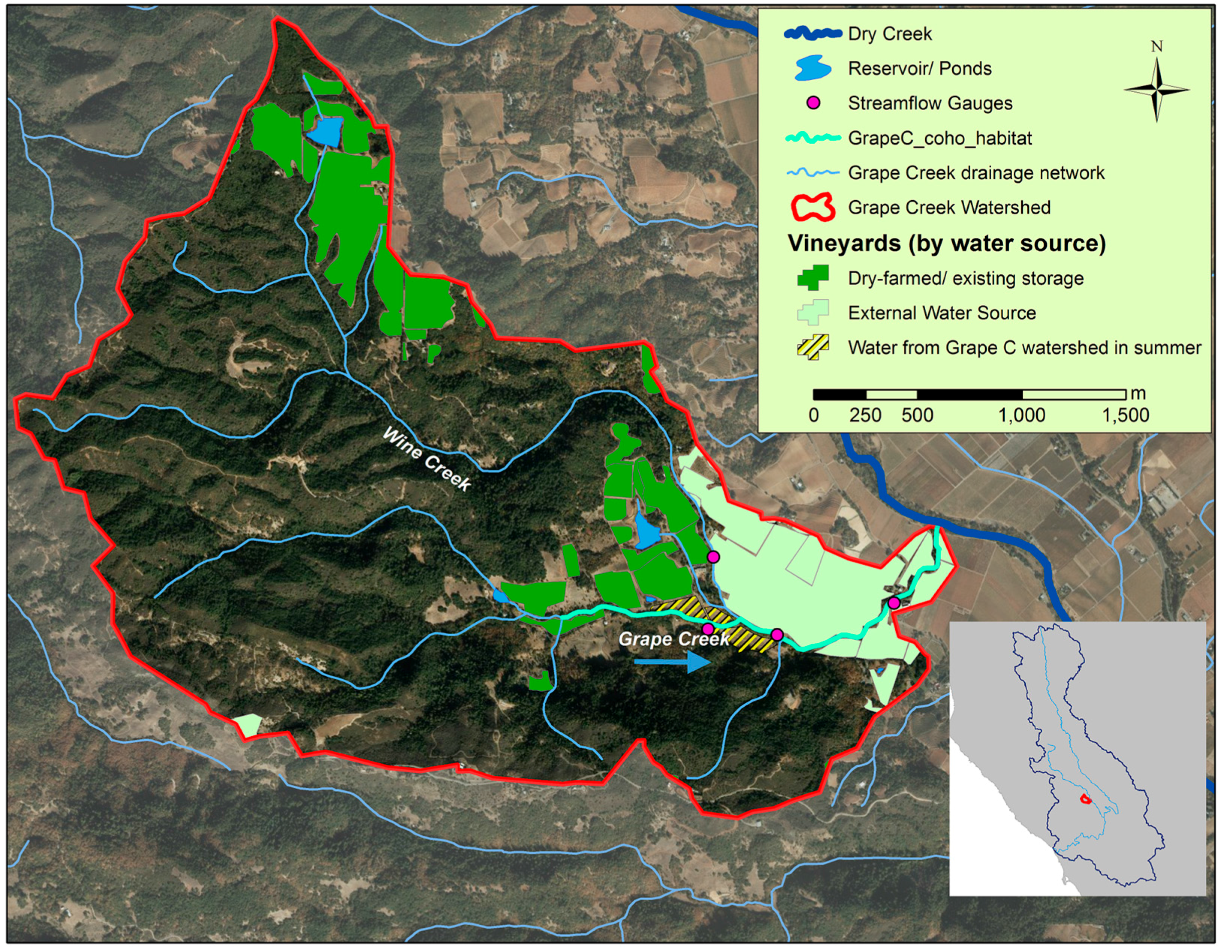
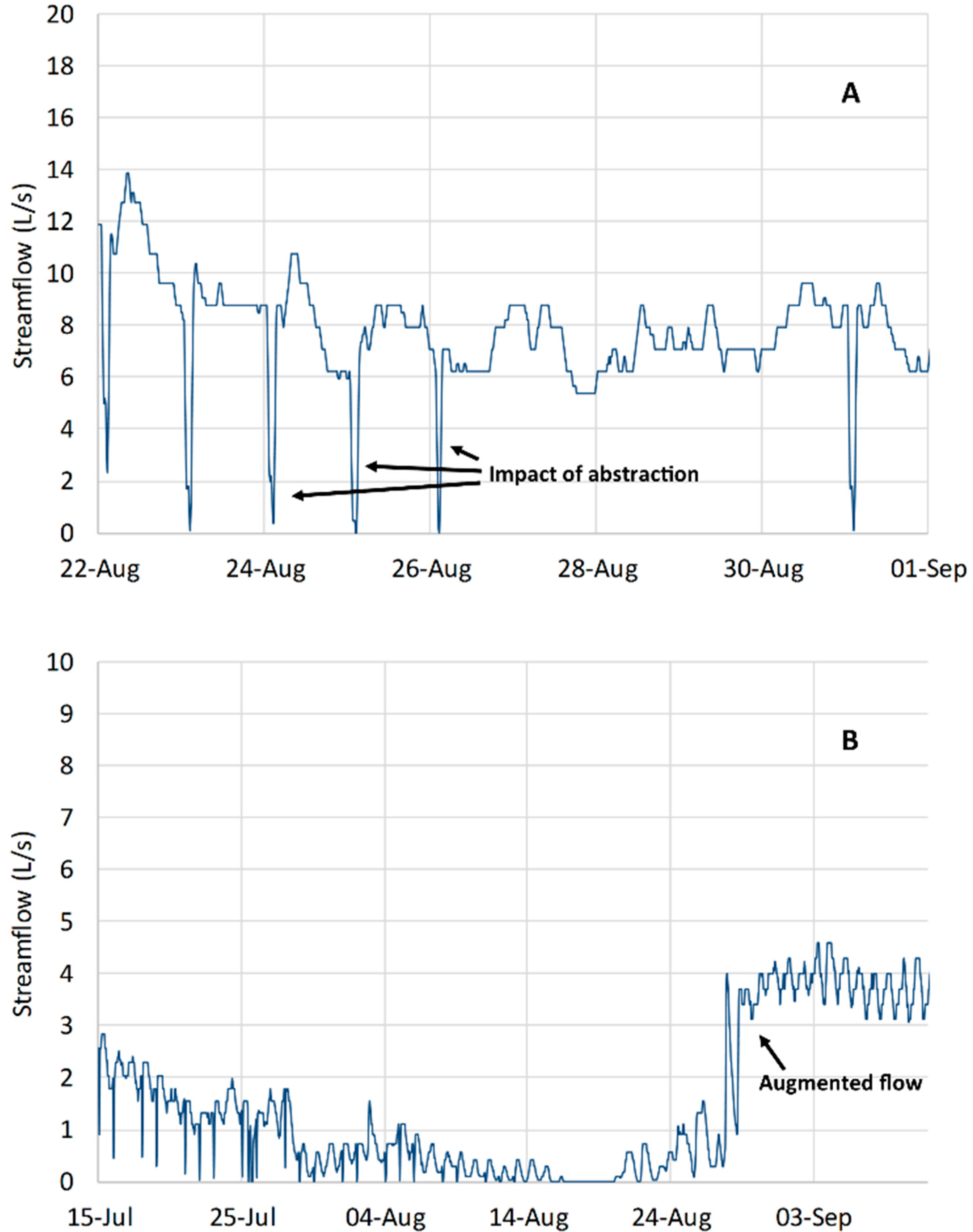
The Russian River Coho Partnership was formed in 2008 as a partnership of conservation-oriented non-governmental organizations (namely, the Sonoma Resource Conservation District, Gold Ridge Resource Conservation District, Trout Unlimited, Center for Ecosystem Management and Restoration, Occidental Arts and Ecology Center, and University of California Sea Grant) with a goal of restoring summer base flow for juvenile salmonids through non-regulatory collaborative partnerships. Here, we present three case studies to describe how we utilized the opportunities and overcame the constraints described above to develop preliminary restoration outcomes in each project watershed. Constraints and opportunities as they apply to each watershed, relative to a general conceptual model of stream restoration [17], are summarized in Table 1.

3.1. Grape Creek

Grape Creek, tributary to Dry Creek and then the Russian River in Sonoma County, CA, USA drains a relatively small (8.4 km2) watershed. Its headwaters are steep and forested, and the lower portion comprises a small valley mostly covered in vineyards (Figure 2). Most of the drainage network is considered too steep to provide viable habitat for salmonids; the salmonid habitat is concentrated in lower valley reaches that flow through vineyard properties. Local residents, some of whom have grown wine grapes along Grape Creek and its main tributary Wine Creek since the 1950s, describe abundant steelhead and coho in Grape Creek historically, but no coho (and few steelhead) were seen in Grape Creek from 1994 to 2012 [34].
Grape Creek was selected for summer flow restoration because of its potential value for coho salmon, likely impacts caused by summer abstractions, and previous restoration activities in the watershed. NOAA Fisheries listed Grape Creek as a Core Watershed for recovery in its Coho Salmon Recovery Plan [2]. Also, members of the Coho Partnership already had relationships with several landowners in the watershed—for example, the conservation group Trout Unlimited partnered with local grape growers in a sustainable water program called Water for Wine in 2008 (focusing on industrial water uses)—and many had already allowed agencies and the local Sonoma RCD to implement projects to enhance steelhead habitat and gauge streamflow on their property. Second, there was interest among landowners, resource agency staff, and fish biologists in finding ways to improve streamflow for salmonids by changing water management practices.
The first streamflow restoration project in Grape Creek began when a landowner who had recently worked with the Sonoma RCD to implement a salmon habitat restoration project approached the RCD to discuss alternatives to his current water management practices. In March of every year, this landowner installed an onstream flashboard dam to provide a pool of water that could be diverted to protect grapes from frost on particularly cold spring mornings after grape buds have emerged (freezing of grape buds would cause the year’s crop to be lost). Based on the vineyard area and typical overhead sprinkler rates associated with frost protection water use [41], we estimated that approximately 1 cubic foot (28 L) of water per second was used to protect the 10-acre vineyard from frost. This often exceeds the flow of Grape Creek in March and April (during the transition period between rainy winter and dry summer), when grape buds are susceptible to frost; this abstraction would cause Grape Creek to become intermittent downstream of the dam when water was used for frost protection. Because of the shape of the vineyard and its surrounding terrain, a large fan was a viable option to provide frost protection; fans provide protection from frost by mixing warmer air at higher elevation with cooler air at ground level, thus increasing temperature of the air at the level of the grape vines. Through a partnership with the landowner, Trout Unlimited, and the Sonoma RCD, it was obtained and installed through federal grant funding. Federal funding availability also was a primary driver for another grower to voluntarily remove 4 acres of grapes (20% of his planted area) to construct a four acre-foot (4900 m3) reservoir (filled by groundwater in winter) to provide a water source for irrigation. The reservoir had been planned for many years because of challenges finding a suitable summer irrigation supply, but a cost match from the USDA EQIP program made its construction feasible.
Pressure transducers installed at four locations in 2009 allowed us to examine how water management practices affected Grape Creek streamflow through the dry season. In the first year of operation, three sequential gauges along Grape Creek measured a reduction in flow on four particularly cold mornings in March and April, indicating abstraction for frost protection from behind another flashboard dam. Flow at the uppermost Grape Creek gauge was reduced by 50%, and then by 25% at two downstream gauges (the latter two gauges were located downstream of the Wine Creek confluence; Figure 2). After sharing our flow data with the landowner, the Sonoma RCD worked with the landowner to design an offstream reservoir that could be filled with groundwater and meet the grower’s water needs for frost protection and irrigation. The reservoir was completed in 2013 and marked the elimination of the final frost protection abstraction from Grape Creek.
Concurrent with gauging streamflow, studies by partnering fish biologists with the University of California Sea Grant Coho Salmon Monitoring Program found that the survival of juvenile coho salmon during summer was limited by low base flow: in two Grape Creek study reaches, more than 80% of juvenile coho survived when flow exceeded 0.1 ft3/s (2.8 L/s), and survival declined precipitously when flow fell below this threshold in very dry years [34,42]. From this information, we set a target goal to restore an average of 0.1 ft3/s (2.8 L/s) through the driest summer months (July through September), which would require an offset of 18 acre-feet (22,000 m3) of water abstraction during this period. GIS tools helped to identify grape growers that believed to be obtaining water from the Grape Creek watershed (either from the stream or adjacent shallow aquifer), and engaged in discussions with these landowners on water sources and interest in offstream storage. The Coho Partnership learned that two of these five grape growers obtained water from the regulated seventh-order Dry Creek, downstream of Warm Springs Dam, and thus did not obtain water from Grape Creek; and two others had reservoirs in an adjacent watershed that provided irrigation water (Figure 2). Another vineyard was dry-farmed. The other grape grower in the watershed used three acre-feet (7300 m3) of water for irrigation, which would correspond to an average of 0.017 ft3/s (0.48 L/s). No other water uses of similar magnitude were identified in the Grape Creek watershed. Though a reservoir has been designed to store 7300 m3 (3 acre-ft) of water for this use and will be constructed when funding is available, it will not meet our goal of offsetting 0.1 ft3/s through summer.
From the Grape Creek case study, we learned that acute impacts to streamflow as indicated by streamflow data provide opportunities to directly benefit flow, but also that preliminary targets may not always be reachable through flow restoration efforts. A number of factors in a watershed can contribute to low flow conditions in coastal California [43], many of them a result of legacy forest management issues having to do with fine sediment accumulation [44] and forest regeneration [45]. Other important lessons learned in Grape Creek were the importance of a healthy egosystem, where landowners and non-regulatory conservation partners could work together to solve problems without fear of regulatory overreach; and the importance of federal funding for dual purposes of supporting endangered species and enhancing individuals’ water supply security.

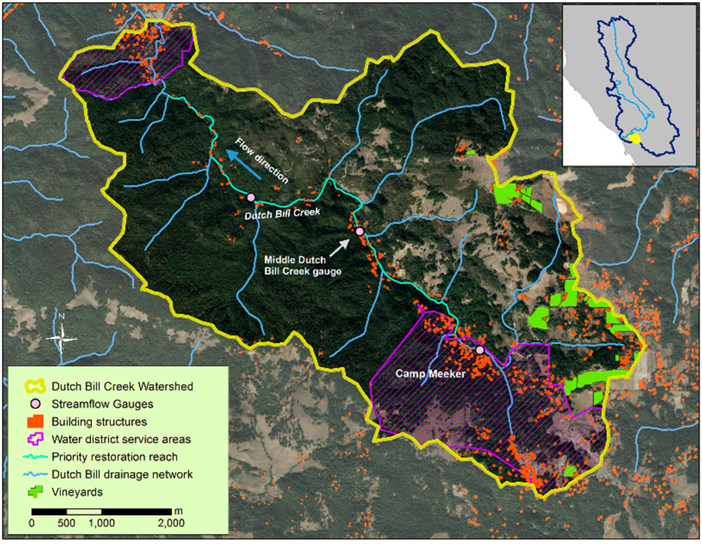
3.2. Dutch Bill Creek
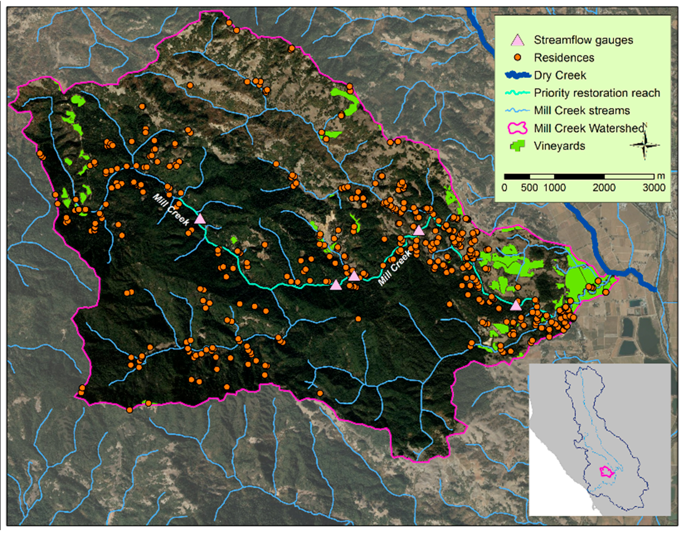
Dutch Bill Creek, tributary to the Russian River near Guerneville, CA, drains approximately 30 square kilometers of mixed fir/redwood and oak woodland, 80 km northwest of the San Francisco Bay. Dutch Bill Creek recedes gradually through the dry season to very low flow, with streamflow approximately 8 to 10 L/s in recent normal-type years. Two small communities in the Dutch Bill Creek watershed (Camp Meeker and Occidental) obtain water from a central supplier via a pipeline that runs upstream from the Russian River; the remainder of the water users in the watershed meet needs from within the Dutch Bill watershed. Outside of the developed communities, most of the residential and commercial development (primarily summer camp/conference centers) is located along Dutch Bill Creek, with agricultural development (mostly comprised of vineyards) on the southeastern hillsides (Figure 3). Dutch Bill Creek was initially selected as a watershed for base flow restoration because of its high value for endangered coho salmon (also a Core Watershed for coho in the NMFS Central California Coast (CCC) Coho Recovery Plan). Residents in the Dutch Bill Creek watershed have been supportive of restoration actions and recovery of endangered species; one of the summer camp/conference centers even hosts 1000-gallon “acclimation tanks” each year for juvenile conservation hatchery coho to imprint with water from Dutch Bill Creek before their release into the stream.
Three streamflow gauges installed in Dutch Bill Creek recorded varying degrees of impairment caused by upstream water uses. The most-upstream gauge at Camp Meeker showed low but steady flow recession through the summer, but the next gauge downstream indicated several sudden drops in flow through the summer, occurring most nights from 1 a.m. to 4 a.m.; after each drop in flow, water rose to its previous level by 6 a.m. (Figure 4A). Discussions with upstream landowners conducted by the Gold Ridge RCD and the Occidental Arts and Ecology Center helped to identify the source of the abstraction (which operated legally under a riparian right); and when landowners were shown how the abstraction drove Dutch Bill Creek to intermittence on most nights through the summer, the landowners were eager to find an alternative water management strategy. This was the only acute impact to flow detected in Dutch Bill Creek.
In 2014, a project was designed with funding from the National Fish and Wildlife Foundation (NFWF) so that the landowner would no longer need to rely on the riparian right from Dutch Bill Creek to meet irrigation needs. The project diminished overall water need by 75% by reducing the irrigated area by 30%, replacing the irrigated field to a type of grass that requires less water through the summer dry season, and upgrading the irrigation system. In a second phase of the project, tanks were constructed to store the remaining water needed from a small unnamed stream in winter and spring rather than in summer, thereby shifting the demand for water to a time when more is available and to a lower rate of abstraction.
In summer 2015, the Camp Meeker Park and Recreation District, which provides municipal water to the community of Camp Meeker along Dutch Bill Creek, volunteered to work with CDFW and NOAA to release unneeded water from its water supply pipe into Dutch Bill Creek [46]. District managers determined that 0.1 ft3/s (3 L/s) could be dedicated to instream flow and released into Dutch Bill Creek through summer. In late August, when Dutch Bill Creek had just become intermittent, flow increased to 3 L/s with the release of water from the Camp Meeker pipeline (Figure 4B). Additional actions to augment base flow are in planning stages elsewhere in the watershed, focusing on reducing summer abstractions from perennial springs that would contribute flow to Dutch Bill Creek if they were not diverted for use through summer.
Constraints and opportunities played a critical role in identifying procedures for flow restoration in Dutch Bill Creek. Streamflow data collection indicated that low summer base flow was exactly the same magnitude as the rate of abstraction by one landowner along the stream. Because that landowner had a positive relationship with the local RCD and others in the Coho Partnership, and because they were a conservation-minded organization, they pivoted quickly to seek alternatives to eliminate their summer abstraction. Because data indicated only one major impact to flow in Dutch Bill Creek, the Coho Partnership was able to focus on obtaining the necessary appropriative water rights and funds to implement the project. Land value and terrain also constrained the project initially: there was insufficient land available to construct a pond to store all the irrigation water that had been used in previous years. However, the landowner worked with project partners to reduce the overall demand for water by more than 75 percent through conservation.

3.3. Mill Creek

The 58 square kilometer Mill Creek watershed contains 325 residences and 210 acres of vineyards distributed over the mostly forested watershed east of Healdsburg, CA [20]. Development is not evenly distributed through the watershed; residences tend to be concentrated along streams and vineyards cover the northern ridgetops (Figure 5). Whereas most vineyards in Mill Creek have ponds believed to store water in winter to meet summer water needs, residents turn to streams, shallow groundwater, and springs to provide domestic water. Like Grape and Dutch Bill Creeks, Mill Creek was selected as a watershed for summer flow restoration because NOAA identified it as a Core Watershed for coho recovery (due to its habitat potential and recent historical populations [2]); and concern over the impacts of summer water use among various types of development in the watershed. Fewer habitat restoration activities have occurred in Mill Creek, compared to Grape Creek, and there was less interest among landowners in engaging with the Sonoma RCD or other project partners to discuss water management to benefit salmonids until three years into the 2012–2015 California drought.
Five streamflow gauges installed in Mill Creek showed no large changes similar to Dutch Bill or Grape Creeks. However, three gauges located in a region of relatively dense housing (100 houses along a 6 km reach) showed small irregular fluctuations comprising up to 25% of flow by late summer during normal-type years. Our data indicated that the number, timing, and magnitude of these changes varied among these three downstream sites; additionally, the farthest downstream site typically has the greatest flow at the beginning of the dry season, but had the least flow by the end (Figure 6). These data suggested that the rural residences along Mill Creek individually had small effects to streamflow compared to large water uses in Grape and Dutch Bill Creeks, but the cumulative effects were substantial.
In 2015, in the sixth year of outreach to landowners along Mill Creek (and the last of four consecutive years of drought), four residential landowners committed to work with the Sonoma RCD to utilize federal grant funds to design and construct projects that will allow storage of rainwater in tanks during winter for use in summer. Individually, these four projects represent a small volume of water: while they replace the needs for these households to divert water from Mill Creek in summer, none of the abstractions they replace are of the magnitude of change recorded by the stream gauges. However, the four projects will demonstrate to landowners in Mill Creek that the Sonoma RCD and its project partners can design and implement winter storage quickly and without regulatory scrutiny. Demonstration will be a key step to scaling up the approach to neighboring landowners in order to improve summer base flow in Mill Creek. Continued financial support will play an important role by allowing the Coho Partnership to continue to cultivate the egosystem in Mill Creek, which is necessary to achieve measurable streamflow restoration outcomes.

4. Discussion

The project examples described above underscore the pressures that the Mediterranean climate places on humans and the aquatic ecosystem in coastal California. The long dry season (which typically results in less than 2 percent of the annual rainfall during summer [19]) necessitates abstraction from naturally occurring or stored water for agricultural and domestic uses, and the absence of large-scale water providers places the burden on landowners to meet water needs individually. The most accessible sources—streams and shallow groundwater—are also those which are necessary for survival of juvenile salmonids through the dry season. Balancing human and environmental needs for water in decentralized settings necessitates planning and coordination in order to maintain adequate supplies for both [33].
In each of the four watersheds described above, shifts in water management practices from summer to winter abstractions are likely to produce small increases in streamflow; but relative to the magnitude of streamflow through the dry season, the effects can be significant. In Grape Creek and Dutch Bill Creek, changes have led to a stabilized flow regime that is no longer driven to zero due to instream abstractions. In Mill Creek, eliminating a few summer abstractions of small magnitude is unlikely to measurably benefit streamflow; but eliminating several may have a cumulative benefit of maintaining flow in an otherwise intermittent channel through the dry season.
One of the key challenges in determining the overall success of restoration projects is whether they can meet the needs of human water users under all conditions—especially under periods of drought, when annual rainfall is likely to be very low. The multiannual variability characteristic of Mediterranean climate regions could lead to an inadequate supply of water during winter, causing water users to meet needs through sources either local (e.g., shallow aquifers) or external (e.g., water delivery trucks). This inter-annual variability has been cited as a major constraint to sustainable water management in California [47], especially relevant given long-term climate trends expected through the 21st Century [48]. While projects typically have been designed for the very driest conditions recorded in recent history, future climate change will likely bring new challenges to meeting human and ecosystem water demands.

4.1. Role of Science in Restoration

Science and adaptive management play key roles in the management and restoration of aquatic ecosystems [49]. High-level regional analyses can provide useful insights for understanding geographic distribution of conditions and trends over time, but they are unlikely to inform appropriate restoration actions on their own. In our project watersheds, spatial GIS-based studies helped us to develop conceptual models and guided preliminary actions by indicating those reaches most likely affected by instream abstractions restoration efforts; but this approach was not at adequate resolution to inform specific restoration strategies. In Dutch Bill Creek, additional studies of streamflow dynamics at a handful of locations along the stream helped us to identify the users of water that had the largest impacts to streamflow, and the magnitude of those impacts. Similar follow-up data collection in Grape Creek helped us to describe the effects of abstraction on streamflow, and discussions with landowners helped to identify those landowners likely to obtain water from within the Grape Creek watershed and those who are not. In each watershed, initial conceptual models, and thus our restoration targets and expected outcomes, were adapted based on follow-up studies and conversations with landowners. Scientific studies were essential for defining the initial problem and identify target reaches for restoration, but additional ground-truthing and landowner conversations were necessary to design meaningful restoration actions.

4.2. The Importance of a Healthy Egosystem

Navigating and cultivating the egosystem has also been an important determinant of whether streamflow restoration success. Residents, and managers, and other watershed stakeholders have provided useful information to understand hydrology and water use dynamics in the region, corroborating theories that emphasize the importance of local knowledge in understanding natural resource dynamics and management [50,51]. In addition to providing information about resource dynamics, successful restoration requires investigating in relationships [52]: our streamflow restoration projects rely upon trust among landowners and outside project partners (e.g., RCDs) to navigate regulatory pathways and implement projects. Water storage projects require landowners to sacrifice privacy, as designers, regulators, project managers, and contractors visit construction sites frequently; landowners frequently express concern that visits by regulatory agency staff may expose them to regulatory enforcement penalties. Though our experience suggests that the risk of heavy-handed regulation is greatly overestimated, many landowners consider signing agreements to forbear use of riparian abstractions as a loss of property rights—even if it would result in a more stable supply of water. This fear of agency overreach has likely played a role in the slow progress of our restoration efforts; for example, after four consecutive years of drought, only six residences (of several hundred) in the Mill Creek watershed have worked with the Sonoma RCD to design water storage projects to meet summer water needs. Meanwhile, commercial water delivery trucks drive through the Mill Creek watershed several times each day through the dry season. A critical objective of these residential water storage projects is to demonstrate that water storage for summer needs is feasible for landowners and can be done without government intervention.
Grape Creek and Dutch Bill Creek benefited from pre-existing relationships and positive social dynamics: The Occidental Arts and Ecology Center had long participated in a Friends of Dutch Bill Creek group; and the Gold Ridge and Sonoma RCDs, Trout Unlimited, University of California Cooperative Extension, fisheries agency staff, and other partners already had worked with landowners in both watersheds on habitat restoration and fisheries monitoring. In Dutch Bill Creek and Grape Creek, moving from habitat enhancement projects to engaging on water supply and instream flow projects was an easier transition because of pre-existing relationships and trust.
The resilience of the egosystem in these project watersheds has been tested over the four-year drought. In addition to resulting in particularly low flow conditions throughout the region, the need to sustain summer streamflow for salmonids prompted the State Water Board to impose informational orders on residents of Dutch Bill and Mill Creeks. Issued in 2015, these new informational orders require landowners to disclose the amount and source of water used during the summer dry season [53]. Since this informational order was issued at the conclusion of the 2012–2015 drought, landowners in project watersheds have been more interested in learning about winter water storage as an alternative to summer abstractions (even after more normal conditions resumed in winter 2016).

4.3. Costs and Benefits

Cost considerations have played an important role in our streamflow restoration projects, with substantial differences in cost distinguished between two broad project categories: water storage and water conservation. Water storage projects tend to be costly, both in terms of the funding needed to implement storage and the amount of space needed for the new infrastructure. Water storage in large tanks typically costs $1 to $2 USD per gallon, including all design and engineering, site preparation, and materials (projects to store 40,000 gallons, or 150 m3, typically cost $50–$70,000 USD). Reservoirs designed to store 0.5 M to 1.2 M gallons (1900 to 4500 m3) can range in cost from $150,000 to over $1,000,000 USD ($0.25 to $2 USD per gallon), depending on site characteristics, design, and complications that arise during construction.
Water storage can also be limited by available space. Small residences may not have space for one 40,000-gallon tank or eight 5000-gallon tanks, so water storage to meet the full range of needs through summer may not be feasible. Similarly, because of the extent of agricultural development in the region, grape growers often must remove vines if they choose to construct a reservoir. In Grape Creek, two separate project landowners committed to removing 20 to 25% of their vineyards to construct a reservoir that will meet summer irrigation needs. In Sonoma County, vineyards range in value from $80,000 to $120,000 USD per acre; this sacrifice of high-value land helps to provide an indirect measure of the value of stable water supply in the region.
In contrast to water storage, water conservation projects reduce the overall water need for a particular use. For example, irrigation volume needed at the summer camp along Dutch Bill Creek fell by 75 percent by reducing the amount of irrigated area by 30 percent and converting its lawn to a drought-tolerant grass type. This reduction in the overall need associated with reduction of irrigated area and change in grass type made water storage feasible: the 250,000 gallons (950 m3) needed for the new reduced lawn area could be stored onsite, whereas there was not adequate space to store the 1 M gallons (3800 m3) that had been used in previous years. Similarly, frost protection fans in Grape Creek offered a reduction in overall water needed for viticulture. Frost fans are not universally appropriate because of geographic limitations (they require a flat space and need the formation of a thermal gradient so that warmer air can be mixed with cooler air at ground level), but they require no water to protect grapes under most (but not all) weather conditions. The frost protection fan for the ten-acre vineyard described above in Grape Creek cost less than $30,000 USD, but was estimated to save more than 2 M gallons of water over ten frost events. Because of their low cost compared to reservoir construction and siting, fans have become a primary tool for frost protection for many grape growers, allowing water to be conserved for when fans may not be sufficient.

4.4. Application beyond the Russian River Watershed

The constraints and opportunities described here are not limited to these three case studies. The biophysical factors of Mediterranean climate, streamflow and groundwater are characteristic of coastal California; and steelhead and/or coho salmon are listed for federal protection from the Mexico border to the Oregon border. The institutional factors described in these three case studies are also common in coastal California: land is expensive, water use is mostly decentralized and distributed through drainage networks, and policies allow for the mix of appropriative and riparian water rights that make it easier to divert water in the summer than in winter. Conservation groups such as Trout Unlimited, California Trout and the Nature Conservancy have teamed with local stakeholder groups to follow similar streamflow restoration processes as those applied to Dutch Bill, Mill and Grape creeks in several coastal counties including Humboldt, Mendocino, Napa, San Mateo, Santa Clara, and San Luis Obispo. Though the climatic and hydrologic factors in coastal California may be similar to other Mediterranean climate regions (e.g., the Mediterranean basin, Chile, Australia, and South Africa), the institutional factors of California combined with the presence of anadromous salmonids may make the extension of the frameworks described here less applicable to other regions beyond California.

5. Conclusions

Characterizing opportunities and constraints has helped to provide a roadmap for streamflow restoration in Mediterranean-climate coastal California. The long summer dry season characteristic of the Mediterranean climate creates pressures for salmonids as well as for land managers and residents across the region, but abundant water in winter provides opportunities for water to be stored when available for use during the dry season. Social and institutional factors also provided constraints as well as opportunities for streamflow restoration. Abstraction during summer under riparian rights are commonplace, and policies designed to protect flow during winter lead to greater oversight from regulatory agencies which have a negative perception in the community. However, the positive relationships between landowners and regional NGOs have helped to assuage these concerns: many of the egosystem challenges that have arisen in the streamflow restoration process have been overcome through demonstrating that collaborative non-regulatory partnerships can successfully implement projects in the region.
The projects we have implemented to date have had positive results on streamflow levels in the region. Most notably, water storage and water conservation projects have led to the elimination of abstractions from Dutch Bill and Grape Creek that had been causing the streams to dry during the dry season. Projects in Mill Creek will likely lead to improved streamflow conditions, but the results are not as clear because the impacts of residential abstractions were not as severe as those of Dutch Bill and Grape Creeks. We expect that many more projects will need to be implemented in Mill Creek before we measure benefits to streamflow during the dry season. With growing interest in using water storage and water conservation to restore summer base flow in coastal California, constraints and opportunities described here provide useful insights for achieving meaningful outcomes in this Mediterranean-climate region.

Acknowledgments

We are grateful for financial support from the California State Coastal Conservancy, and the National Fish and Wildlife Foundation through its Russian River Coho Salmon Keystone Initiative (Grants #19137, #26020, #30513, #36529, and #41344); and in particular, Michael Bowen, Jim Sedell, Claire Thorp, Mike Chrisman, and David Lawrence, for their support of these projects. We also thank Michele Goodfellow with the University of Florida and project partners Mariska Obedzinski, Sarah Nossaman, John Green, Valerie Minton, Justin Bodell, Playalina Nelson, Herman Garcia, Matt Clifford, Brian Johnson, Gordon Becker, and Mia van Docto; the Sonoma County Water Agency, California Department of Fish and Wildlife, NOAA Fisheries, Region 1 Water Quality Control Board, UC Hopland Cooperative Extension Center, and the many landowners in each watershed who have supported our project. The authors also thank three anonymous reviewers whose thoughtful reviews and insightful input greatly improved the quality of this article.

Author Contributions

Matthew J. Deitch and Brock Dolman conceived the framing of restoration conceptual models and institutional interactions; Matthew J. Deitch wrote the paper.

Conflicts of Interest

The authors have no interest or relationship, financial or otherwise, that might be perceived as influencing an author’s objectivity or any other conflict of interest.

References

  1. State Water Resources Control Board. Policy for Maintaining Instream Flows in Northern California Coastal Streams; SWRCB Division of Water Rights, California Environmental Protection Agency: Sacramento, CA, USA, 2010.
  2. National Marine Fisheries Service. Final Recovery Plan for Central California Coast Coho Salmon Evolutionarily Significant Unit; National Marine Fisheries Service, Southwest Region: Santa Rosa, CA, USA, 2012.
  3. Langridge, R. Changing Legal Regimes and the Allocation of Water between Two California Rivers. Natl. Resour. J. 2002, 42, 283–330. [Google Scholar]
  4. Deitch, M.J.; Kondolf, G.M.; Merenlender, A.M. Surface water balance to evaluate the hydrological impacts of small instream diversions and application to the Russian River basin, California, USA. Aquat. Conserv. Mar. Freshw. Ecosyst. 2009, 19, 274–284. [Google Scholar] [CrossRef]
  5. Gasith, A.; Resh, V.H. Streams in Mediterranean climate regions: Abiotic influences and biotic responses to predictable seasonal events. Annu. Rev. Ecol. Syst. 1999, 17, 51–81. [Google Scholar] [CrossRef]
  6. Beche, L.A.; Mcelravy, E.P.; Resh, V.H. Long-term seasonal variation in the biological traits of benthic-macroinvertebrates in two Mediterranean-climate streams in California, USA. Freshw. Biol. 2006, 51, 56–75. [Google Scholar] [CrossRef]
  7. Resh, V.H.; Beche, L.A.; Lawrence, J.E.; Mazor, R.D.; McElravy, E.P.; O’Dowd, A.P.; Rudnick, D.; Carlson, S.M. Long-term population and community patterns of benthic macroinvertebrates and fishes in Northern California Mediterranean-climate streams. Hydrobiologia 2012. [Google Scholar] [CrossRef]
  8. Bogan, M.T.; Hwan, J.L.; Carlson, S.M. High aquatic biodiversity in an intermittent coastal headwater stream at Golden Gate National Recreation Area, California. Northwest Sci. 2015, 89, 188–197. [Google Scholar] [CrossRef]
  9. Moyle, P.B. Inland Fishes of California; University of California Press: Berkeley, CA, USA, 2002. [Google Scholar]
  10. Harvey, B.C.; Nakamoto, R.J.; White, J.L. Reduced streamflow lowers dry-season growth of rainbow trout in a small stream. Trans. Am. Fish. Soc. 2006, 135, 998–1005. [Google Scholar] [CrossRef]
  11. Grantham, T.E.; Newburn, D.A.; McCarthy, M.A.; Merenlender, A.M. The role of streamflow and land use in limiting oversummer survival of juvenile steelhead in California streams. Trans. Am. Fish. Soc. 2012, 141, 585–598. [Google Scholar] [CrossRef]
  12. Kleinfelder Inc. Pilot Study of Groundwater Conditions in the Joy Road, Mark West Springs, and Bennett Valley Areas of Sonoma County, California; Sonoma County Permit Resource Management Department: Santa Rosa, CA, USA, 2004.
  13. Johnson, B.J. Reasonable Use on the Russian River: A Brief History of the Frost Protection Rule. Gold. Gate Univ. Environ. Law J. 2016, 9, 41–65. [Google Scholar]
  14. Moyle, P.B. Novel aquatic ecosystems: The new reality for streams in California and other Mediterranean climate regions. River Res. Appl. 2014, 30, 1335–1344. [Google Scholar] [CrossRef]
  15. Deitch, M.J.; Kondolf, G.M.; Merenlender, A.M. Hydrologic impacts of small-scale instream diversions for frost protection and heat protection in the California wine country. River Res. Appl. 2009, 25, 118–134. [Google Scholar] [CrossRef]
  16. Gilvear, D.J.; Spray, C.J.; Casas-Mulet, R. River rehabilitation for the delivery of multiple ecosystem services at the river network scale. J. Environ. Manag. 2013, 126, 30–43. [Google Scholar] [CrossRef] [PubMed]
  17. Beechie, T.; Pess, G.; Roni, P.; Giannico, G. Setting river restoration priorities: A review of approaches and a general protocol for identifying and prioritizing actions. N. Am. J. Fish. Manag. 2008, 28, 891–905. [Google Scholar] [CrossRef]
  18. Barmuta, L.A.; Linke, S.; Turak, E. Bridging the gap between ‘planning’ and ‘doing’ for biodiversity conservation in freshwaters. Freshw. Biol. 2011, 56, 180–195. [Google Scholar] [CrossRef]
  19. Deitch, M.J.; Goodfellow, M.; Feirer, S.T. Spatial and temporal variability of rainfall among Mediterranean climate regions across the globe. Water 2016. under review. [Google Scholar]
  20. Deitch, M.J.; Kondolf, G.M. Salmon in a Mediterranean Climate: California’s Incendiary Mix. In Sustainable Water: Challenges and Solutions from California; Lassiter, A., Ed.; University of California Press: Berkeley, CA, USA, 2015; pp. 269–291. [Google Scholar]
  21. Van Dijk, A.I.; Beck, H.E.; Crosbie, R.S.; Jeu, R.A.; Liu, Y.Y.; Podger, G.M.; Timbal, B.; Viney, N.R. The Millennium Drought in southeast Australia (2001–2009): Natural and human causes and implications for water resources, ecosystems, economy, and society. Water Resour. Res. 2013, 49, 1040–1057. [Google Scholar] [CrossRef]
  22. Hwan, J.L.; Carlson, S.M. Fragmentation of an Intermittent Stream during Seasonal Drought: Intra-annual and Interannual Patterns and Biological Consequences. River Res. Appl. 2015, 32, 856–870. [Google Scholar] [CrossRef]
  23. Wilhite, D.A.; Hayes, M.J.; Knutson, C.L. Drought preparedness planning: Building institutional capacity. In Drought and Water Crises: Science, Technology, and Management Issues; Wilhite, D.A., Ed.; CRC Press: Boca Raton, FL, USA, 2005; pp. 93–135. [Google Scholar]
  24. Keeley, J.E. Native American impacts on fire regimes of the California coastal ranges. J. Biogeogr. 2002, 29, 303–320. [Google Scholar] [CrossRef]
  25. Deitch, M.J.; van Docto, M.; Feirer, S.T. A spatially explicit framework for assessing the effects of weather and water rights on streamflow. Appl. Geogr. 2016, 67, 14–26. [Google Scholar] [CrossRef]
  26. Serra-Llobet, A.; Conrad, E.; Schaefer, K. Governing for Integrated Water and Flood Risk Management: Comparing Top-Down and Bottom-Up Approaches in Spain and California. Water 2016, 8, 445. [Google Scholar] [CrossRef]
  27. California State Water Resources Control Board. California Code of Regulations, Title 23: Excerpts of Divisions 3–5 Applicable to the Administration of Water Rights; SWRCB Division of Water Rights, California Environmental Protection Agency: Sacramento, CA, USA, 2016. Available online: http://www.waterboards.ca.gov/laws_regulations/docs/wrregs.pdf (accessed on 1 November 2016).
  28. Sax, J.L.; Thompson, B.H.; Leshy, J.D.; Abrams, R.H. Legal Control of Water Resources: Cases and Materials, 3rd ed.; West Group Publishing: St. Paul, MN, USA, 2000. [Google Scholar]
  29. Littleworth, A.L.; Garner, E.L. California Water II; Solano Press: Point Arena, CA, USA, 2007. [Google Scholar]
  30. State Water Resources Control Board, Division of Water Rights. eWRIMS GIS Application. Available online: https://waterrightsmaps.waterboards.ca.gov/ewrims/gisapp.aspx (accessed on 1 November 2016).
  31. Hanemann, M.; Dyckman, C.; Park, D. California’s flawed surface water rights. In Sustainable Water: Challenges and Solutions from California; Lassiter, A., Ed.; University of California Press: Berkeley, CA, USA, 2015; pp. 52–82. [Google Scholar]
  32. Fitchette, T. California Grape Vineyard Values Remain Strong; Western Farm Press: Fresno, CA, USA, 15 December 2015; Available online: http://www.westernfarmpress.com/grapes/california-grape-vineyard-values-remain-strong (accessed on 1 November 2016).
  33. Grantham, T.E.; Merenlender, A.M.; Resh, V.H. Climatic influences and anthropogenic stressors: An integrated framework for streamflow management in Mediterranean-climate California, USA. Freshw. Biol. 2010, 55, 188–204. [Google Scholar] [CrossRef]
  34. Trout Unlimited and Center for Ecosystem Management and Restoration. Grape Creek Streamflow Improvement Plan; Trout Unlimited California: Berkeley, CA, USA, 2013; Available online: https://caseagrant.ucsd.edu/sites/default/files/Grape%20Creek%20Streamflow%20Improvement%20Plan%20%28Pub%20Date%20April%202013%29_0.pdf (accessed on 1 November 2016).
  35. Mill Creek Streamflow Improvement Plan. Produced by The Russian River Coho Water Resources Partnership, Comprised of the Center for Ecosystem Management and Restoration, Gold Ridge Resource Conservation District, Occidental Arts and Ecology Center WATER Institute, Sonoma Resource Conservation District, Trout Unlimited California, and University of California Sea Grant. 2014. Available online: http://cohopartnership.org/Mill-Creek-Streamflow.pdf (accessed on 01 November 2016).
  36. Deitch, M.J.; Merenlender, A.M.; Feirer, S.T. Cumulative effects of small reservoirs on streamflow in northern Coastal California catchments. Water Resour. Manag. 2013. [Google Scholar] [CrossRef]
  37. California Department of Fish and Wildlife. State Streamlines Domestic Water Tank Storage Process in Response to Drought; California Department of Fish and Wildlife: Sacramento, CA, USA, 2014; Available online: https://cdfgnews.wordpress.com/2014/03/13/state-streamlines-domestic-water-tank-storage-process-in-response-to-drought/ (accessed on 1 November 2016).
  38. Kovner, G. Sonoma County Vineyard Owners Lauded for Water Conservation; Santa Rosa Press Democrat: Santa Rosa, CA, USA, 5 October 2015; Available online: http://www.pressdemocrat.com/news/4555747-181/sonoma-county-vineyard-owners-lauded (accessed on 1 November 2016).
  39. Bouleau, G.; Kondolf, M. Rivers of Diversity: Water Regulation in California and the EU. In Transatlantic Regulatory Cooperation: The Shifting Roles of the EU, the US and California; Vogel, D., Swinnen, J.F.M., Eds.; Edward Elgar: Cheltenham, UK, 2011; pp. 83–101. [Google Scholar]
  40. Montgomery, D. King of Fish: The Thousand-Year Run of Salmon; Westview Press: Boulder, CO, USA, 2003. [Google Scholar]
  41. Smith, R.J.; Klonsky, K.M.; Livingston, P.L.; DeMoura, R.L. Sample Costs to Establish a Vineyard and Produce Wine Grapes: North Coast Region Sonoma County; University of California Cooperative Extension: Davis, CA, USA, 2004. [Google Scholar]
  42. Obedzinski, M.; Pecharich, J.C.; Davis, J.A.; Nossaman, S.; Olin, P.G.; Lewis, D.G. Russian River Coho Salmon Captive Broodstock Program Monitoring Activities: Annual Report, July 2007 to June 2008; University of California Cooperative Extension and Sea Grant Program: Santa Rosa, CA, USA, 2009. [Google Scholar]
  43. Asarian, J.E.; Walker, J.D. Long-Term Trends in Streamflow and Precipitation in Northwest California and Southwest Oregon, 1953–2012. J. Am. Water Resour. Assoc. 2016, 52, 241–261. [Google Scholar] [CrossRef]
  44. May, C.L.; Lee, D.C. The relationships among in-channel sediment storage, pool depth, and summer survival of juvenile salmonids in Oregon Coast Range streams. N. Am. J. Fish. Manag. 2004, 24, 761–774. [Google Scholar] [CrossRef]
  45. Stubblefield, A.; Kaufman, M.; Blomstrom, G.; Rogers, J. Summer Water Use by Mixed-Age and Young Forest Stands, Mattole River, Northern California, USA; General Technical Reports PSW-GTR-238; Pacific Southwest Research Station, Forest Service, U.S. Department of Agriculture: Albany, CA, USA, 2012.
  46. Kovner, G. Flowing Again, Russian River’s Creeks Open for Spawning Coho Salmon; The Santa Rosa Press Democrat: Santa Rosa, CA, USA, 21 December 2015; Available online: http://www.pressdemocrat.com/news/4962232-181/flowing-again-russian-rivers-creeks?artslide=0 (accessed on 1 November 2016).
  47. Georgakakos, A.P.; Yao, H.; Kistenmacher, M.; Georgakakos, K.P.; Graham, N.E.; Cheng, F.Y.; Spencer, C.; Shamir, E. Value of adaptive water resources management in Northern California under climatic variability and change: Reservoir management. J. Hydrol. 2012, 412, 34–46. [Google Scholar] [CrossRef]
  48. Cook, B.I.; Ault, T.R.; Smerdon, J.E. Unprecedented 21st century drought risk in the American Southwest and Central Plains. Sci. Adv. 2015, 1, e1400082. [Google Scholar] [CrossRef] [PubMed]
  49. Downs, P.W.; Kondolf, G.M. Post-project appraisals in adaptive management of river channel restoration. Environ. Manag. 2002, 29, 477–496. [Google Scholar] [CrossRef]
  50. Berkes, F.; Turner, N.J. Knowledge, learning and the evolution of conservation practice for social-ecological system resilience. Hum. Ecol. 2006, 34, 479–494. [Google Scholar] [CrossRef]
  51. Berkes, F. Rethinking community-based conservation. Conserv. Biol. 2004, 18, 621–630. [Google Scholar] [CrossRef]
  52. Morrison, M.; Oczkowski, E.; Greig, J. The primacy of human capital and social capital in influencing landholders’ participation in programmes designed to improve environmental outcomes. Aust. J. Agric. Resour. Econ. 2011, 55, 560–578. [Google Scholar] [CrossRef]
  53. State Water Resources Control Board. Order WR 2015-0026-DWR Order for Additional Information in the Matter of Diversion of Water from Dutch Bill Creek, Green Valley Creek, Portions of Mark West Creek, and Mill Creek Watersheds; California Environmental Protection Agency: Sacramento, CA, USA, 2015. Available online: http://www.waterboards.ca.gov/waterrights/water_issues/programs/drought/rrtribs.shtml (accessed on 1 November 2016).
Figure 1. Average monthly discharge as a percentage of average annual discharge in seven streams in coastal California (developed using historical streamflow data form the U.S. Geological Survey).
Water 09 00029 g001
Figure 2. Agricultural development, surface water features, and streamflow gauge locations in the Grape Creek watershed (and relative to the Russian River and Dry Creek in the Russian River watershed, inset).
Water 09 00029 g002
Figure 3. Agricultural development, building structures, and streamflow gauge locations in the Dutch Bill Creek watershed (including those buildings in areas served by centralized water providers).
Water 09 00029 g003
Figure 4. Streamflow in Dutch Bill Creek, showing impacts of abstraction on some mornings in Summer 2011 (A) and increased streamflow as a result of released flow in summer 2015 (B). Streamflow fluctuations around 24 August 2015 are a result of preliminary test flow releases.
Water 09 00029 g004
Figure 5. Agricultural development, building structures, and streamflow gauge locations in the Mill Creek watershed.
Water 09 00029 g005
Figure 6. Streamflow at three locations, above, within, and below a reach of particularly dense housing along Mill Creek (recorded July through September of normal-type year 2011).
Water 09 00029 g006
Table 1. Constraints and opportunities encountered for streamflow restoration projects in Russian River tributaries, relative to a general conceptual model of restoration planning.
Step 1: identifying problem/defining objectives
Constraints:Opportunities:
Low summer rainfall/inter-annual variabilityIn Grape Creek, Mill Creek, and Dutch Bill Creek, the summer dry season results in streamflow on same order of magnitude as typical water abstractions.Winter water abundanceIn Grape Creek, Mill Creek, and Dutch Bill Creek, the water needed annually for human uses represents less than 5% of average winter rainfall and less than 10% of average winter stream discharge.
Dual water rights systemIn Grape Creek, Mill Creek, and Dutch Bill Creek, more people obtain water through riparian right in summer than through appropriative right in winter.
STEP 2: CONDUCTING ASSESSMENTS
Constraints:Opportunities:
Low summer rainfall/inter-annual variabilityIn Grape Creek and Mill Creek, naturally low flow confounded the detection of impairment relative to baseline low flow conditions (especially during drought years).Planning toolsIn Grape Creek, Mill Creek, and Dutch Bill Creek, field-based streamflow data collection indicated where impacts to flow were greatest; and GIS-based desktop studies provided estimates of how much water was needed for various human uses.
Decentralized water managementIn Grape Creek, Mill Creek, and Dutch Bill Creek, tens to hundreds of individuals obtain water from streams or shallow groundwater during the summer dry season, spread across the watershed, with varying rates of abstraction.
STEP 3: PROPOSING/TESTIMG TREATMENTS
Constraints:Opportunities:
Dual water rights systemIn Grape Creek, Mill Creek, and Dutch Bill Creek, laws require thorough evaluation of water availability to obtain an appropriative water right for winter water storage (no studies are necessary to obtain a riparian right).Well-cultivated egosystemIn Grape Creek and Dutch Bill Creek, Resource Conservation Districts had long-standing positive relationships with stakeholders developed through implementation of successful stream-related restoration projects.
In Mill Creek, streamflow impairment may be caused by the cumulative effect of hundreds of small abstractions throughout the drainage network. In Mill Creek, fewer restoration projects had been implemented and thus additional time was required to reach landowners and discuss project objectives.
Land ownership characteristicsIn Grape Creek, Mill Creek, and Dutch Bill Creek, suitable land for constructing adequate storage may be limited by terrain (e.g., a property is too mountainous), or by cost (e.g., vineyard land is too valuable to convert to a reservoir).Charismatic megafaunaIn Grape Creek, Mill Creek, and Dutch Bill Creek, landowners were interested in learning what they could do to help salmonids survive through the dry summer.
Decentralized water managementIn Mill Creek, streamflow impairment may be caused by the cumulative effect of hundreds of small abstractions throughout the drainage network.In Grape Creek and Dutch Bill Creek, landowners changed water management practices because we showed them the effects their actions were having on streamflow.
Institutional fragmentationIn Grape Creek, Mill Creek, and Dutch Bill Creek, water storage required permits from the State Water Board, CDFG, and Sonoma County; and consultation with NMFS, the Army Corps of Engineers, and the Regional Water Quality Control Board.Drought as opportunityIn Grape Creek and Dutch Bill Creek, drought caused landowners to volunteer water conservation actions aimed at improving conditions for oversummering define salmonids
In Mill Creek, drought led landowners to seek winter water storage to improve security of their summer water supply.
Funding streamsIn Grape Creek, Mill Creek, and Dutch Bill Creek, RCDs, landowners, and others stakeholders sought newly available funds from the state of California, federal agencies (e.g., NOAA, USDA) and foundations (e.g., NFWF) for project planning and implementation.

