
Groundwater Origins and Circulation Patterns Based on Isotopes in Challapampa Aquifer, Bolivia


Abstract
:1. Introduction
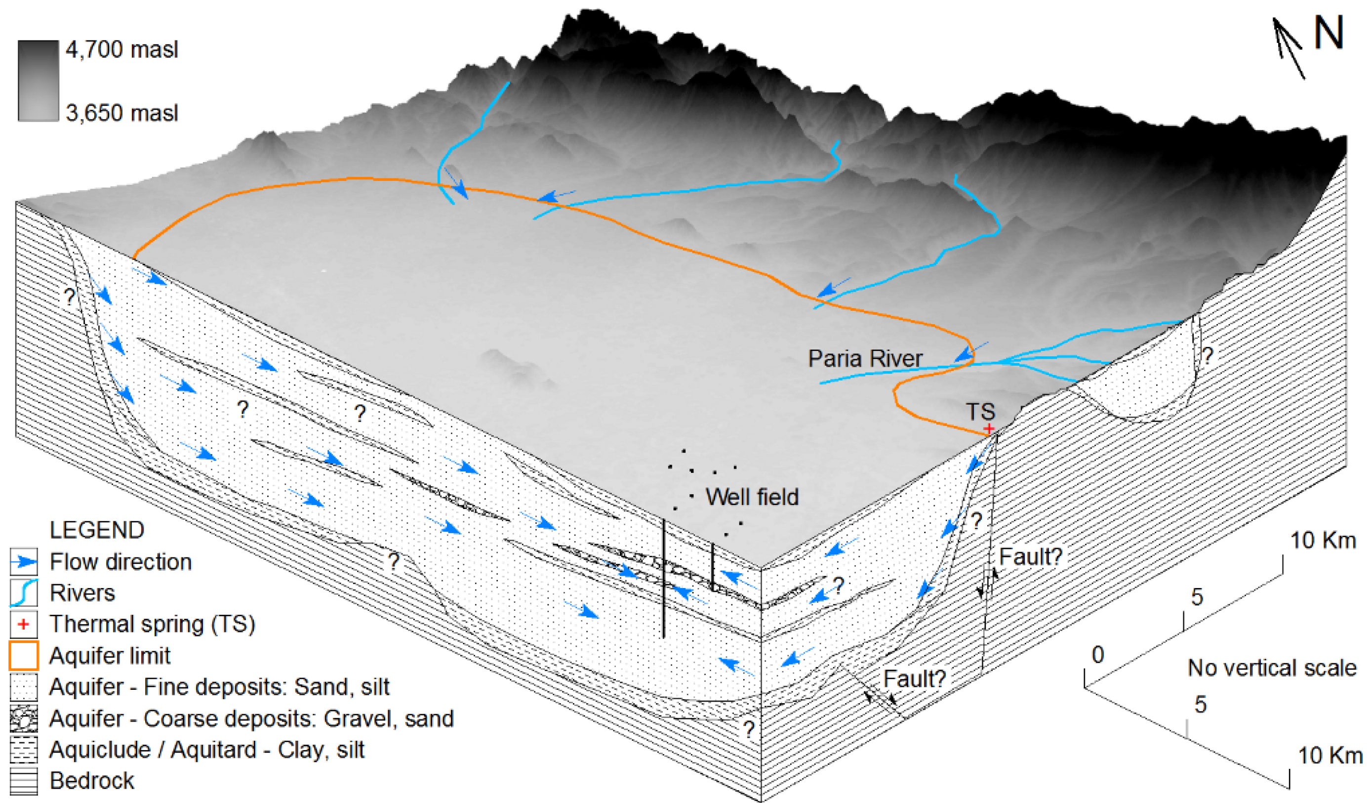
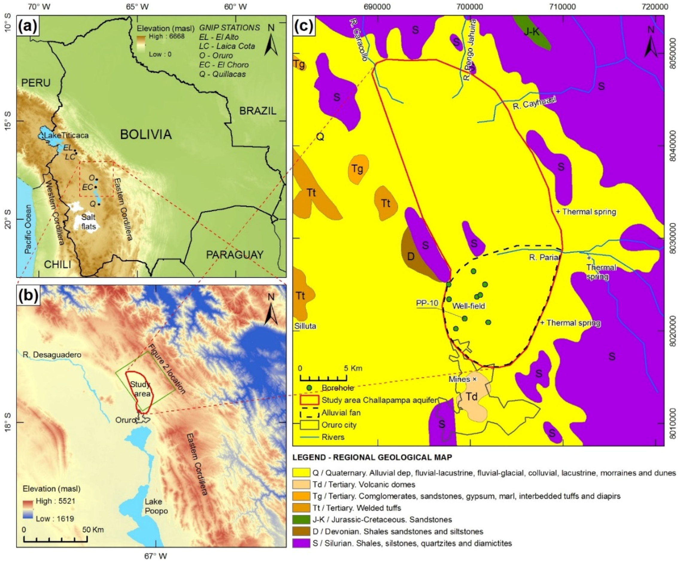
2. Study Area
3. Data, Sampling and Methods
4. Results and Discussion
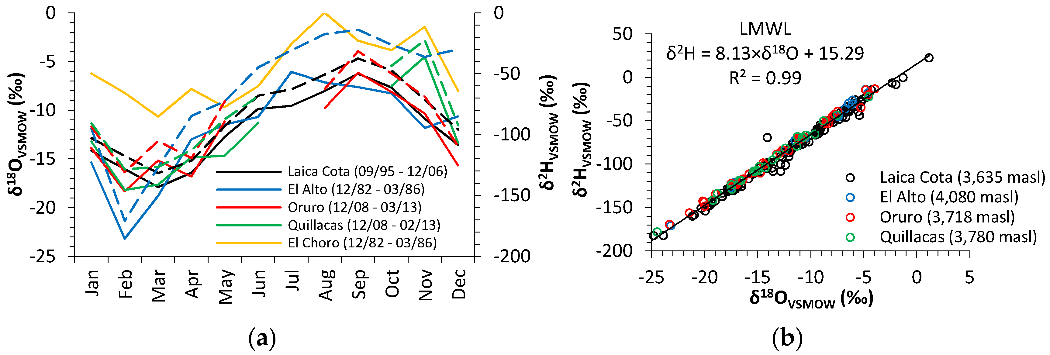
4.1. Isotopic Compositions in Precipitation
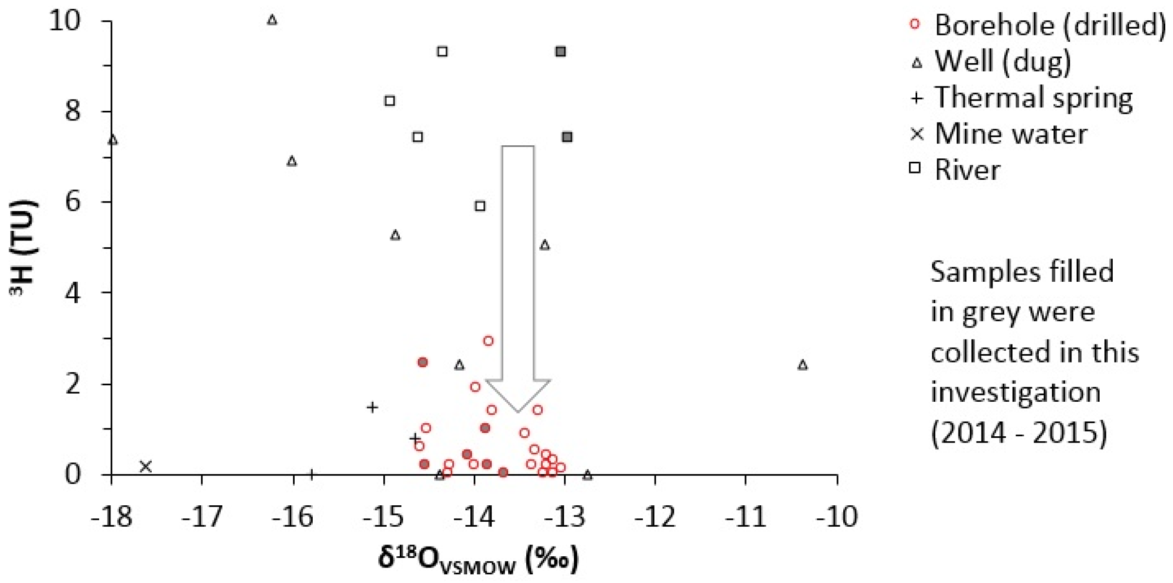
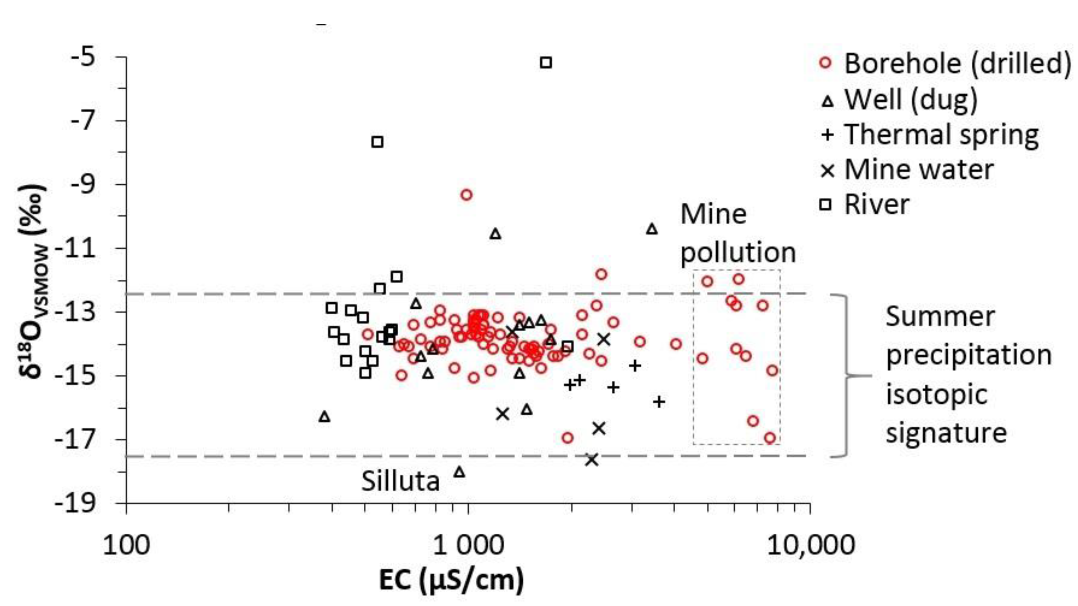
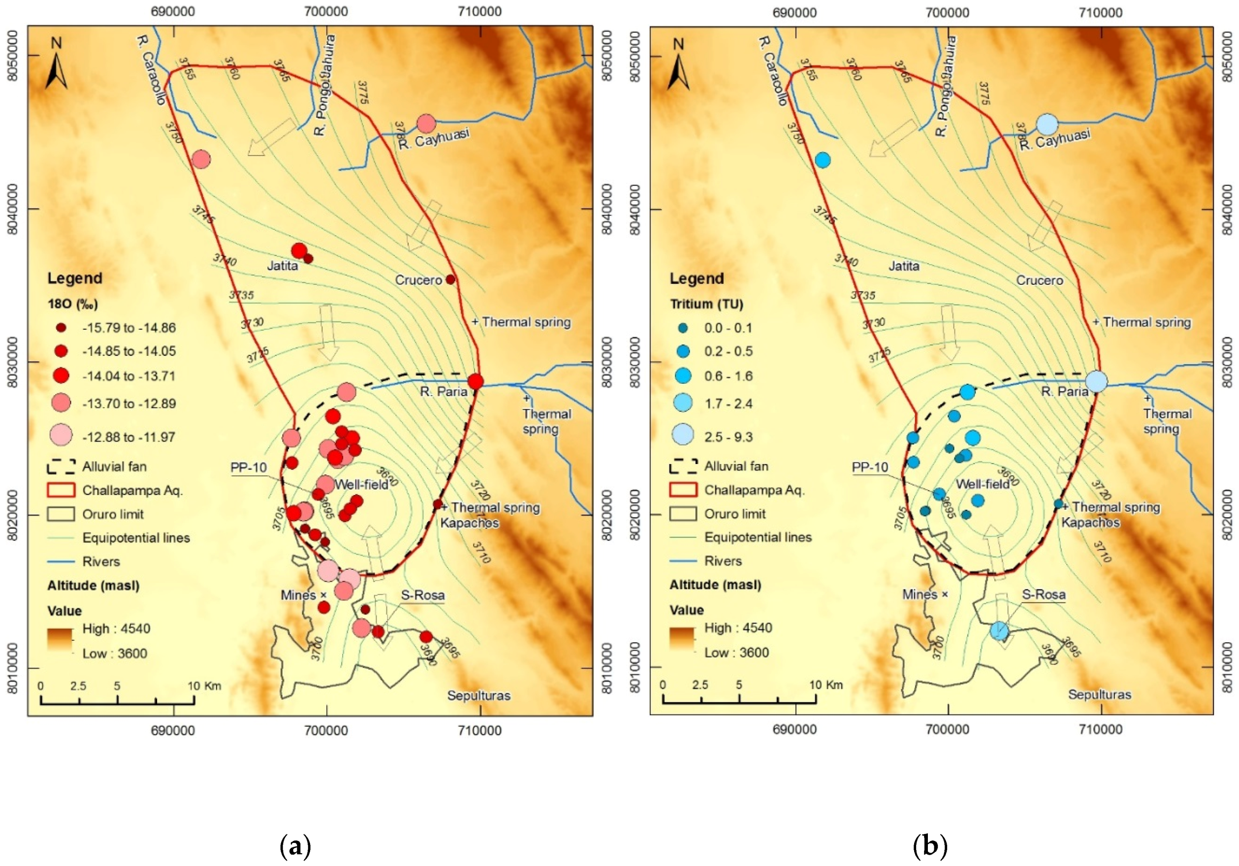
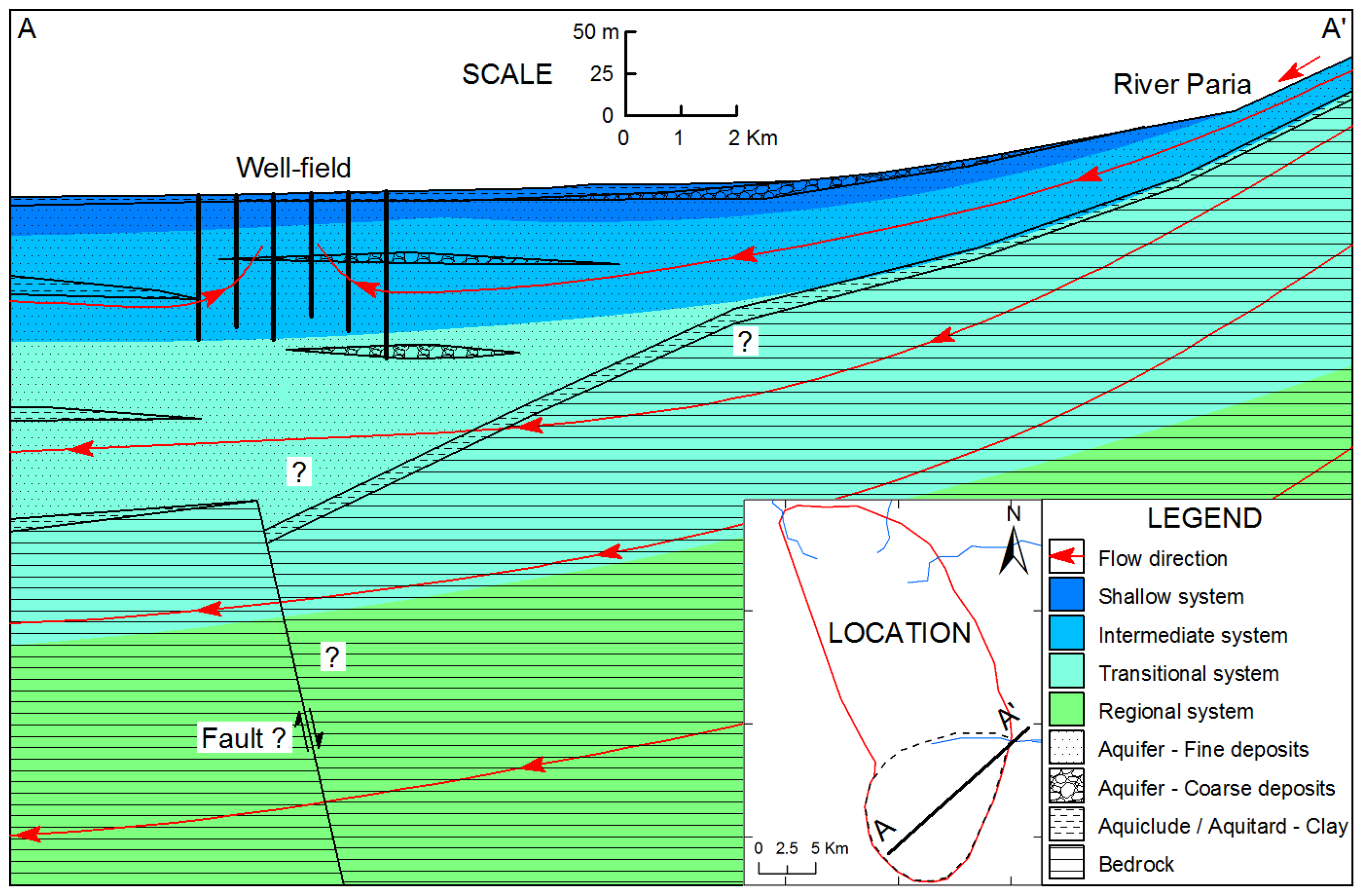
4.2. Isotopic Compositions in Surface Water and Groundwater
5. Conclusions
Acknowledgments
Author Contributions
Conflicts of Interest
Abbreviations
| DJFM | December, January, February, and March |
| EC | Electrical conductivity |
| GMWL | Global Meteoric Water Line |
| GNIP | Global Network for Isotopes in Precipitation |
| IAEA | International Atomic Energy Agency |
| LMWL | Local Meteoric Water Line |
| PDB | Pee Dee Belemnite |
| PMC | Percentage of modern carbon |
| SELA | Servicio Local de Acueductos y Alcantarillado Oruro |
| TDPS | Titicaca, Desaguadero, Poopo, and the salt flats |
| VSMOW | Vienna Standard Mean Ocean Water |
References
- Subyani, A.M. Use of chloride-mass balance and environmental isotopes for evaluation of groundwater recharge in the alluvial aquifer, Wadi Tharad, western Saudi Arabia. Environ. Geol. 2004, 46, 741–749. [Google Scholar] [CrossRef]
- Ramos, O.E.; Caceres, L.F.; Ormachea, M.R.; Bhattacharya, P.; Quino, I.; Quintanilla, J.; Sracek, O.; Thunvik, R.; Bundschuh, J.; Garcia, M.E. Sources and behavior of arsenic and trace elements in groundwater and surface water in the Poopó Lake Basin, Bolivian Altiplano. Environ. Earth Sci. 2011, 66, 793–807. [Google Scholar] [CrossRef]
- Yin, L.; Hou, G.; Su, X.S.; Wang, D.; Dong, J.; Hao, Y.; Wang, X. Isotopes (δD and δ18O) in precipitation, groundwater and surface water in the Ordos Plateau, China: Implications with respect to groundwater recharge and circulation. Hydrogeol. J. 2011, 19, 429–443. [Google Scholar] [CrossRef]
- Banks, D.; Holden, W.; Aguilar, E.; Mendez, C.; Koller, D.; Andia, Z.; Rodriguez, J.; Saether, O.M.; Torrico, A.; Veneros, R.; et al. Contaminant source characterization of the San Jose Mine, Oruro, Bolivia. Geol. Soc. Lond. Special Publ. 2002, 198, 215–239. [Google Scholar] [CrossRef]
- Canaviri, B. Estimación de la Vulnerabilidad Intrínseca a la Contaminación del Aquífero Libre en el Sistema Acuífero de Challapampa Oruro. Bachelor’s Thesis, Universidad Técnica de Oruro, Oruro, Bolivia, 2011. [Google Scholar]
- D’Elia, M. Asesoramiento para el Diseño e Implementación de la Red de Monitoreo de Aguas Subterráneas en la Cuenca del Lago Poopó; Programa de Gestión Sostenible de los Recursos Naturales de la Cuenca del Lago Poopó Convenio No. DCI-ALA/2009/021–614; Gobierno Autónomo Departamental De Oruro: Oruro, Bolivia, 2013. (In Spanish) [Google Scholar]
- Gitec-Cobodes, L.C.G. Poopo Lake Basin Management Plan Formulation; Programa de gestion sostenible de los recursos naturales de la cuenca del lago Poopo; Gobierno Autónomo Departamental De Oruro: Oruro, Bolivia, 2014. [Google Scholar]
- Fiorella, R.P.; Poulsen, C.J.; Pillco, R.; Barnes, J.B.; Tabor, C.R.; Ehlers, T.A. Spatiotemporal variability of modern precipitation δ18O in the central Andes and implications for paleoclimate and paleoaltimetry estimates. J. Geophys. Res. Atmos. 2015, 120, 1–27. [Google Scholar] [CrossRef]
- Global Network of Isotopes in Precipitation. Available online: http://www.iaea.org/water (accessed on 11 May 2016).
- Coudrain-Ribstein, A.; Talbi, A.; Loubet, M.; Gallaire, R.; Jusserand, C.; Ramirez, E.; Ledoux, E. Isotopic and chemical composition of groundwater in the Bolivian altiplano, present space evolution records hydrologic conditions since 11,000 Yr. In Proceedings of the Vienna Symposium Mai 1999, Vienna, Austria, 10–14 May 1999.
- Lizarazu, J.; Aranyossy, J.F.; Orsag, V.; Salazar, J.C. Estudio Isotopico de la cuenca de Oruro-Caracollo (Bolivia). In Proceedings of Symposium of Isotope Techniques in Water Resources Development, Vienna, Austria, 30 March–3 April 1987.
- Swedish Geological, A.B. Impacto de la Contaminación Minera e Industrial Sobre agua Subterráneas; Ministerio de Desarrollo Sostenible y Medio Ambiente, Secretaria Nacional de Mineria: Oruro, Bolivia, 1996. (In Spanish)
- Coudrain-Ribstein, A.; Pratz, B.; Quintanilla, J.; Zuppi, G.M.; Cahuaya, D. Salinidad del recurso hídrico sobterráneo del Altiplano Central. Le Bull. de l’Institut Fr. d’études Andin. 1995, 24, 483–493. (In Spanish) [Google Scholar]
- Calizaya, A. Water Resources Management Efforts for Best Water Allocation in the Lake Poopo Basin, Bolivia. Ph.D. Thesis, Lund University, Lund, Sweden, 2009. [Google Scholar]
- Pillco, R.; Bengtsson, L. Long-term and extreme water level variations of the shallow Lake Poopó, Bolivia. Hydrol. Sci. J. 2006, 51, 98–114. [Google Scholar]
- Carta Geológica de Bolivia. Hoja Oruro, Publicación SGB Serie I-CGB-11. Servicio Geológico de Bolivia. Geobol; Swedish Geological, A.B.: La Paz, Bolivia, 1992.
- Zapata, R. Modelo Conceptual Hidrogeológico del Sistema Acuífero de un Abanico Aluvial en la Sub-Cuenca del río Poopó: Oruro-Bolivia. Master’s Thesis, Universidad Mayor Real y Pontificia de San Francisco Xavier de Chuquisaca, Sucre, Bolivia, 2011. [Google Scholar]
- Servicio Local de Acueductos y Alcantarillado de Oruro. Available online: http://selaoruro.gob.bo/ (accessed on 11 May 2016).
- Fornari, M.; Risacher, F.; Féraud, G. Dating of paleolakes in the central Altiplano of Bolivia. Palaeogeogr. Palaeoclimatol. Palaeoecol. 2001, 172, 269–282. [Google Scholar] [CrossRef]
- Rigsby, C.A.; Bradbury, J.P.; Baker, P.A.; Rollins, S.M.; Warren, M.R. Late Quaternary palaeolakes, rivers, and wetlands on the Bolivian Altiplano and their palaeoclimatic implications. J. Quat. Sci. 2005, 20, 671–691. [Google Scholar] [CrossRef]
- Thompson, L.G.; Mosley-Thompson, E.; Henderson, K.A. Ice-core paleoclimate records in tropical South America since the Last Glacial Maximum. J. Quat. Sci. 2000, 15, 377–394. [Google Scholar] [CrossRef]
- Gonfiantini, R.; Roche, M.A.; Olivry, J.C.; Fontes, J.; Zuppi, G.M. The altitude effect on the isotopic composition of tropical rains. Chem. Geol. 2001, 181, 147–167. [Google Scholar] [CrossRef]
- Seiler, K.P.; Gat, J.R. Groundwater Recharge from Run-Off, Infiltration and Percolation; Springer: Berlin, Germany, 2007. [Google Scholar]
- Isotope Methods for Dating Old Groundwater. Available online: http://www-pub.iaea.org/books/IAEABooks/8880/Isotope-Methods-for-Dating-Old-Groundwater (accessed on 11 May 2016).
- Servicio Nacional de Meteorologia e Hidrologia de Bolivia. Available online: http://www.senamhi.gob.bo/ (accessed on 11 May 2016).
- Gat, J.R. Oxygen and Hydrogen Isotopes in the Hydrologic Cycle. Annual Rev. Earth Planet. Sci. 1996, 24, 225–262. [Google Scholar] [CrossRef]
- Craig, H. Isotopic Variations in Meteoric Waters. Sci. New Series 1961, 133, 1702–1703. [Google Scholar] [CrossRef] [PubMed]
- Aravena, R.; Suzuki, O.; Peña, H.; Pollastri, A.; Fuenzalida, H.; Grilli, A. Isotopic composition and origin of the precipitation in Northern Chile. Appl. Geochem. 1999, 14, 411–422. [Google Scholar] [CrossRef]
- Uribe, J.; Muñoz, J.F.; Gironás, J.; Oyarzún, R.; Aguirre, E.; Aravena, R. Assessing groundwater recharge in an Andean closed basin using isotopic characterization and a rainfall-runoff model: Salar del Huasco basin, Chile. Hydrogeol. J. 2015, 1–17. [Google Scholar] [CrossRef]
- Johnson, E.; Yáñez, J.; Ortiz, C.; Muñoz, J. Evaporation from shallow groundwater in closed basins in the Chilean Altiplano. Hydrol. Sci. J. 2010, 55, 624–635. [Google Scholar] [CrossRef]
- Thompson, L.G.; Davis, M.E.; Mosley-Thompson, E.; Sowers, T.A.; Henderson, K.A.; Zagorodnov, V.S.; Lin, P.; Mikhalenko, V.N.; Campen, R.K.; Bolzan, J.F.; et al. A 25,000-Year Tropical Climate History from Bolivian Ice Cores. Science 1998, 282, 1858–1864. [Google Scholar] [CrossRef] [PubMed]


| Reference | Sampling Year | Sampling Sites Reported | Sampling Sites Located | Isotopes Reported | Types of Sampling Sites |
|---|---|---|---|---|---|
| Lizarazu et al. (1987) [11] | 1984–1985 | 61 | 25 | 18O, 2H, 3H, 13C, and 14C | Boreholes, dug wells, springs, rivers, and mines |
| Swedish Geological AB (1996) [12] | 1996 | 23 | 0 | 18O | Boreholes and dug wells |
| Gitec & Cobodes (2014) [7] | 2013 | 6 | 6 | 18O, 2H, 3H and 14C | Boreholes and rivers |
| Present study | 2014–2015 | 17 | 17 | 18O and 2H | Boreholes, dug wells, and rivers |
| Sample | Depth * (mbs) | Type ** | EC (μS/cm) | δ18O (‰) | δ2H (‰) | 3H *** (TU) | 13C *** (‰) | 14C *** (pMC) |
|---|---|---|---|---|---|---|---|---|
| PP-07 | 48–80 | B/WF | 979 | −13.86 | −107.72 | 1.0 | −9.04 | 72.8 |
| PP-09 | 38–71 | B/WF | 1172 | −13.67 | −108.05 | BDL | −9.89 | 38.1 |
| PP-10 | 39–84 | B/WF | 4130 | −14.05 | −111.46 | 0.4 | −9.47 | 25.9 |
| PP-11 | 36–84 | B/WF | 956 | −13.83 | −107.72 | 0.2 | −8.63 | 40.5 |
| PP-14 | – | B/WF | 1043 | −13.80 | −109.44 | – | – | – |
| PP-17 | 22–79 | B/WF | 1339 | −14.13 | −111.18 | – | – | – |
| PP-20 | – | B/WF | 1130 | −14.09 | −110.43 | – | – | – |
| PP-21 | – | B/WF | 850 | −14.19 | −109.21 | – | – | – |
| PP-22 | – | B/WF | 844 | −13.32 | −105.84 | – | – | – |
| PP-23 | 32–97 | B/WF | 1251 | −13.73 | −107.47 | – | – | – |
| Sela-2 | 38–53 | B/WF | 1357 | −14.52 | −112.50 | 0.2 | −9.27 | 30.5 |
| Crucero | – | B | 932 | −14.86 | −113.51 | – | – | – |
| Sta-Rosa | – | B | 1432 | −14.55 | −111.39 | 2.4 | −9.04 | 79.3 |
| Jatita-I | 65 | B | 760 | −14.91 | −114.85 | – | – | – |
| Jatita-II | <10 | D | 734 | −13.94 | −107.85 | – | – | – |
| Cayhuasi | 0 | R | 460 | −13.01 | −99.24 | 9.3 | – | – |
| Paria | 0 | R | 407 | −12.95 | −99.34 | 7.4 | – | – |
© 2016 by the authors; licensee MDPI, Basel, Switzerland. This article is an open access article distributed under the terms and conditions of the Creative Commons Attribution (CC-BY) license (http://creativecommons.org/licenses/by/4.0/).
Share and Cite
Gómez, E.; Barmen, G.; Rosberg, J.-E. Groundwater Origins and Circulation Patterns Based on Isotopes in Challapampa Aquifer, Bolivia. Water 2016, 8, 207. https://doi.org/10.3390/w8050207
Gómez E, Barmen G, Rosberg J-E. Groundwater Origins and Circulation Patterns Based on Isotopes in Challapampa Aquifer, Bolivia. Water. 2016; 8(5):207. https://doi.org/10.3390/w8050207
Chicago/Turabian StyleGómez, Etzar, Gerhard Barmen, and Jan-Erik Rosberg. 2016. "Groundwater Origins and Circulation Patterns Based on Isotopes in Challapampa Aquifer, Bolivia" Water 8, no. 5: 207. https://doi.org/10.3390/w8050207