
Daily Precipitation Changes over Large River Basins in China, 1960–2013


1
Key Laboratory of Water Cycle and Related Land Surface Processes, Institute of Geographic Sciences and Natural Resources Research, CAS, Beijing 100101, China
2
University of Chinese Academy of Sciences, Beijing 100049, China
*
Author to whom correspondence should be addressed.
Water 2016, 8(5), 185; https://doi.org/10.3390/w8050185
Submission received: 23 February 2016
/
Revised: 25 April 2016
/
Accepted: 26 April 2016
/
Published: 2 May 2016
(This article belongs to the Special Issue Advances in Hydro-Meteorological Monitoring)
Abstract
:Based on a high-quality dataset of 713 daily precipitation series, changes in daily precipitation events during 1960–2013 were observed in China’s ten largest river basins. Specifically, the amount of precipitation in four categories defined by fixed thresholds and their proportion on total precipitation were analyzed on annual and seasonal time scales. Results showed annual precipitation increased by 1.10 mm/10yr in China, but with obvious spatial differences. Regionally, annual precipitation increased significantly in northwestern rivers, upstream areas of the Yangtze River, the Yellow River, southwestern rivers (due to increase in light and moderate precipitation); and in southeastern rivers, downstream areas of the Yangtze River, and the Pearl River (due to increase in heavy and extreme precipitation). Annual precipitation decreased significantly in the mid-Yangtze River and upstream Pearl River (due to decrease in light, moderate, and heavy precipitation). Seasonally, precipitation decreased only in autumn; this was attributable to a decrease in light and moderate precipitation. Results show that the distribution of precipitation intensity over China has shifted to intense categories since the 1960s, there has been an increase in moderate precipitation in Northwestern and Northern China, and an increase in extreme precipitation in Southeastern China. This shift was detected in all seasons, especially in summer. Precipitation extremes were investigated in the categories of extreme precipitation and results show that the risk of flood has been exacerbated over the past half-century in the Huaihe River, the mid- and lower Yangtze River, the Pearl River, and southeastern rivers.
1. Introduction
As global climate experiences significant change with increasing concentrations of greenhouse gasses [1], assessing changes in climatic variables has become a key issue for researchers around the world [2]. Although it is widely recognized that global temperature is increasing significantly, there are large uncertainties concerning precipitation change because of variabilities in time and space [3]. Revealing changes in precipitation receives great interest because of its importance to agriculture, water supply, and natural hazards, such as droughts and floods.
Precipitation can be observed and analyzed in terms of long-term mean state and the intensity and frequency of precipitation events. Global land precipitation has increased by about 2% since 1900 [4], but this increase has been neither spatially nor temporally uniform [3].
A study of the US also showed a precipitation increase during the 20th century; the increase was most pronounced during the warm season [5]. To detect changes in the frequency and intensity of precipitation, daily precipitation is usually categorized using two methods: percentile thresholds and fixed thresholds. They are both widely used in many studies [1,5,6,7]. Brunetti et al. observed changes in daily precipitation within percentile categories across Italy and found that the significant decrease in frequency of precipitation was due to a decrease in low-intensity precipitation events [6]. Using fixed thresholds, Karl et al. observed that the proportion of total precipitation contributed by extreme precipitation had increased significantly within the US [8]. In the hydrological cycle, the frequency and intensity of precipitation directly affect rainfall-runoff processes and further determine regional water resources. For example, in forest stands, the proportion of interception loss could be up to 100% in light precipitation, while the loss could be 25% in heavy precipitation [9]. Percentile categories are generally defined by specific quantiles of the precipitation distribution at a single station, such as the top 5% for extreme precipitation [6] and bottom 50% for light precipitation [7]. Li et al. showed extreme events by the top 5% of precipitation distribution was about 10~20mm/d in Western China [10]. Additionally, the mean intensity of precipitation in the same percentile at different stations, therefore, could be different. Although percentile categories benefit the detection of precipitation changes across regions and seasons [1,6], fixed categories could be more useful in hydrological models, as rainfall-runoff processes generally derive from the amount of precipitation events across a river basin.
In recent years, changes in precipitation characteristics have also been widely discussed in China. Liu et al. found that the frequency of precipitation decreased by a significant 10% over the same period for most of China, except the northwest [1]. Precipitation extremes have also been studied extensively in China. A more recent study by Wu et al. found that heavy precipitation events had higher rates of change than did mean precipitation [7]. The river basin is an important unit in hydrological processes. Water resource management is principally practiced at the basin scale [11]. It is, therefore, valuable to identify precipitation changes at that scale. Precipitation extremes are one focus in studies over basins in China. Chen et al. studied precipitation extremes in large basins across China [12] and, similarly, studies were also performed in the Yangtze River [13], Pearl River [14,15], Lancang River [16], and Yellow River [17]. Zhang and Cong analyzed the mean intensity and frequency of precipitation events in large river basins across China from 1956 to 2005. Their results indicated that precipitation intensity had significantly increased, while precipitation frequency had decreased in all basins except for rivers in the northwest [11]. Changes in the distribution of precipitation intensity, however, are rarely explored in river basins across China. In hydrology, if the distribution of precipitation intensity shifts, even when there is no change in total precipitation, runoff quantities would also significantly change due to changes in rainfall-runoff processes. A relative study is, therefore, urgently needed in China.
Climatic variability research, however, is not an easy task. One of the greatest problems in examining climate change is a lack of high-quality long-term data [6] because of non-climatic noise in climate signals [18]. Although researchers have understood that developing reliable datasets is essential in climate-change studies, checking prospective datasets and adjusting for biases has received little attention around the world and in China.
This study focused on changes in daily precipitation of different intensities over large river basins in China and attempted to reveal changes in the distribution of precipitation intensity in these basins. The research first considered issues of quality control, homogeneity, and completeness and a high-quality dataset of daily precipitation was produced. Second, changes in daily precipitation were analyzed on annual and seasonal time scales during the past half-century. Specifically, fixed thresholds were used to categorize precipitation events. The amount and proportion of precipitation by category and annual or seasonal precipitation were calculated for every station each year, and then the trends were analyzed across China and its ten largest river basins. This paper is organized as follows. Section 2 describes the data, data-processing methods, and analysis methods used in this study. Results and analysis are presented in Section 3, and the discussion and conclusion are given in Section 4.
2. Data and Methodology
2.1. Data and Pre-Processing
The observed daily precipitation dataset obtained from the Chinese National Meteorological Center was used in our study. It contained 819 stations for the period from 1 January 1951 to 31 December 2013. This dataset is well distributed across China, including the Tibetan plateau [1], and is widely used in all kinds of studies [19,20,21,22,23,24]. In the 1950s, however, there were only about 160 to 400 stations with available data [25]. We, therefore, restricted our study to the period 1960–2013.
2.1.1. Quality Control
Quality control is an essential part of climatic variability research [26]. The dataset used in this study was compiled with quality control procedures including the extreme value test, consistency check, and spatial outliers test [11]. A detailed description of these procedures can be found in the work of Feng et al. and Qian and Lin. The study by Feng et al. applied quality control tests to daily meteorological data for 1951–2000 from the same source we used, and only 0.02% stations showed low quality [22]. We, therefore, considered the precipitation data to be of good quality.
2.1.2. Data Homogeneity
The homogeneity of meteorological data has been highlighted in many studies; climatic variability research is not possible without clear knowledge about it [18,27,28,29,30,31,32,33]. A number of non-climatic factors, including station relocation and changes in instruments, observing regulations, and algorithms for the calculation of means, can introduce bias into climatological time series [6]. These biases have disturbed the record of actual climatic variations over time [30].
A variety of direct and indirect methods has been developed to identify and adjust for inhomogeneities [18]. A comprehensive review of such methods was given by Peterson et al. [30]. In China, only 60 stations have metadata available [22], which the direct correction techniques for inhomogeneities require. Relatively indirect methods were, therefore, chosen for this study. Most of the indirect methods are based on the comparison of a candidate series with a reference series formed from nearby or correlative stations; these include Potter’s ratio test [34], the standard normal homogeneity test (SNHT) [32], Bayesian procedures [20], and multiple linear regression [31].
No complete protocol, however, is available for processing daily precipitation datasets [27] and most methods were developed for monthly or annual data [30]. For daily precipitation, precipitation frequency is an important factor that affects the homogeneity of a time series [6,29]. Brunetti et al. attempted to check the homogeneity of daily precipitation records. They tested two kinds of heterogeneities in daily precipitation records: (1) the precipitation amount and (2) the number of rainy days [6]. This study followed their methods in that both precipitation amount and rainy days per month were used to evaluate the homogeneity in dataset. One of the most-used methods to identify inhomogeneities, the standard normal homogeneity test (SNHT) developed by Alexandersson was mostly used [27,35]. In China, Feng et al. also applied the SNHT method to identify inhomogeneity in daily meteorological data. Therefore, SNHT was used in this study.
After identifying inhomogeneities of our dataset, 11 stations showed homogeneity problems in precipitation amount and more stations, 57 stations, displayed homogeneity problems in rainy days. Among them, four stations were overlapped. At the end, a set of 755 stations constitute the newly-homogenized dataset in this study.
2.1.3. Missing Values
Missing values could also introduce bias in a climatological time series, so we attempted to fill in any missing values before proceeding. At first, we filtered the dataset to exclude stations with more than five missing years (nearly 10% of study period) between 1960 and 2013. Specifically, following Lucie et al., the monthly and, consequently, annual, values were considered to be missing when data for more than three consecutive days or more than five random days within a month were missing [36]. In the end, 713 of 755 stations with more than 48 years of complete data remained in our study (Figure 1).
Each candidate station subjected to the SNHT was compared to a reference series created to identify its inhomogeneities. The reference series is a weighted average of a number of the nearest available stations [30]. The SNHT reference series was used to fill in the missing values from the 713 stations.
2.2. Methodology
The China Meteorological Administration (CMA) categorizes daily precipitation (P) into five intensity groups: P < 10 mm/d, 10 ≤ P < 25 mm/d, 25 ≤ P < 50 mm/d, 50 ≤ P < 100 mm/d, and P ≥ 100 mm/d. Since the P ≥ 100 mm/d group occurs infrequently in Northern China [13], following Gong et al., we combined the last two groups and defined four categories: light precipitation (<10 mm/d), moderate precipitation (10–25 mm/d), heavy precipitation (25–50 mm/d), and extreme precipitation (≥50 mm/d). The amount and proportion of daily precipitation falling into these four categories were calculated for each station. We then analyzed the trends over China and in its ten large river basins (Figure 1).
2.2.1. Trends Detection
In this study, the trends were analyzed using the Mann-Kendall test, which is well suited to non-normally distributed data [37,38] and has been widely used in many previous studies [6,7]. To remove lag-1 autocorrelation in a time series, which could overestimate significance of the Mann-Kendall test, the trend-free pre-whitening (TFPW) method developed by Yue et al. was adopted before applying the Mann-Kendall test [38].
The Mann-Kendall test represents a ranked-based approach. The test statistic S is given as follows:
where:
and are the sequential data values, and n is the length of the dataset.
A positive value of S indicates an upward trend and a negative value of S indicates a downward trend. The test is conducted using the normal distribution, with the expectation (E) and variance (V) as follows:
where is the number of data points in the kth tied group and h is the number of tied groups in the dataset.
The Mann-Kendall Z is then calculated by:
The Z value can be related to a p-value of a specific trend. In a two-sided test for trend, the null hypothesis of no trend is accepted if , where is the significance level [39]. The null hypothesis of no trend is rejected if > 1:65, > 1:96 and > 2:57 at the 10%, 5%, and 1% significance levels, respectively.
2.2.2. Spatial Interpolation
Meteorological stations can provide reliable and accurate precipitation data, but their spatial distribution is generally uneven in China [7]. In order to explore the temporal variation of ten large river basins, Kriging interpolation was chosen to generate grid data due to its good performance with geographic data [41]. The spherical semi-variogram model was used as the weighting function in interpolation [11]. Trends across the whole country and each basin were then derived from regional averaged data from 1960 to 2013.
3. Results and Analysis
3.1. Annual Character of Precipitation Tendencies
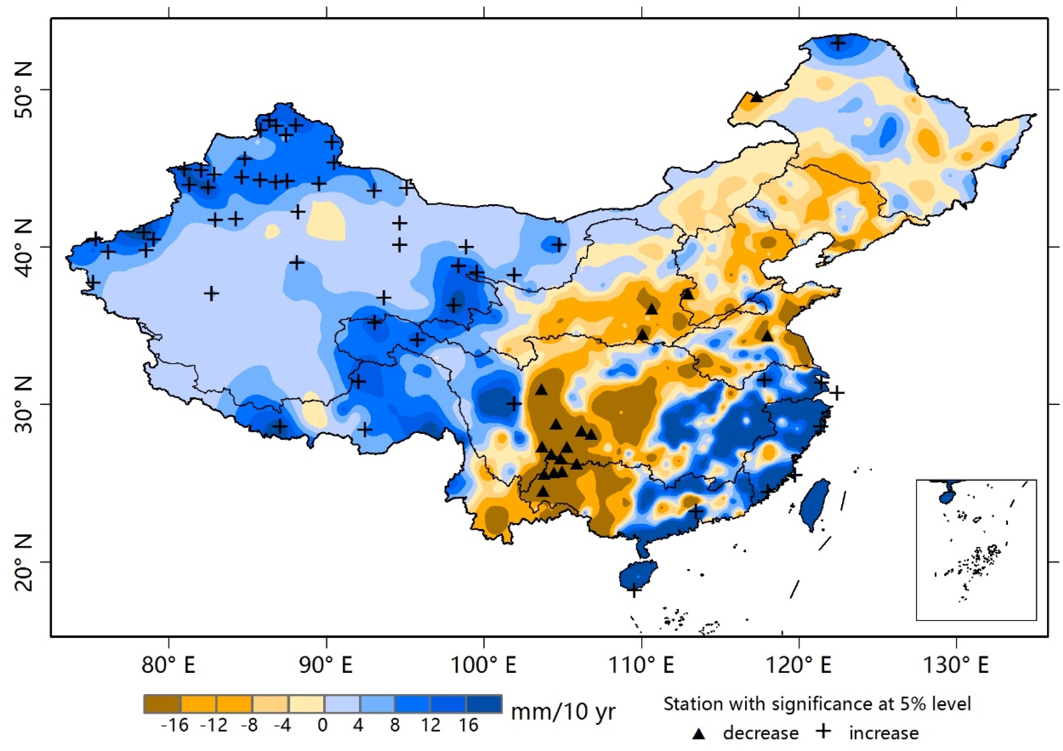
The Mann-Kendall trends for annual precipitation during 1960–2013 are shown in Figure 2. Stations with a significance level of 0.05 are labeled by pluses (positive) or triangles (negative). The averaged trends over China and its ten large river basins are showed in Table 1.
Over the past half-century, annual precipitation increased in China at a magnitude of 1.10 mm/10yr, but this trend was not statistically significant (Table 1). Regionally, significantly increasing trends occurred in the eastern coastal region, northwestern China, and the Tibetan Plateau, while significantly decreasing trends occurred in southwestern and northern China (Figure 2). In the ten large river basins, significant uptrend was observed in southwestern rivers. Large downtrends were observed in the Huaihe, Liaohe, and Haihe Rivers, while large uptrends were observed in southeastern rivers and northwestern rivers, although these findings were not statistically significant (Table 1).
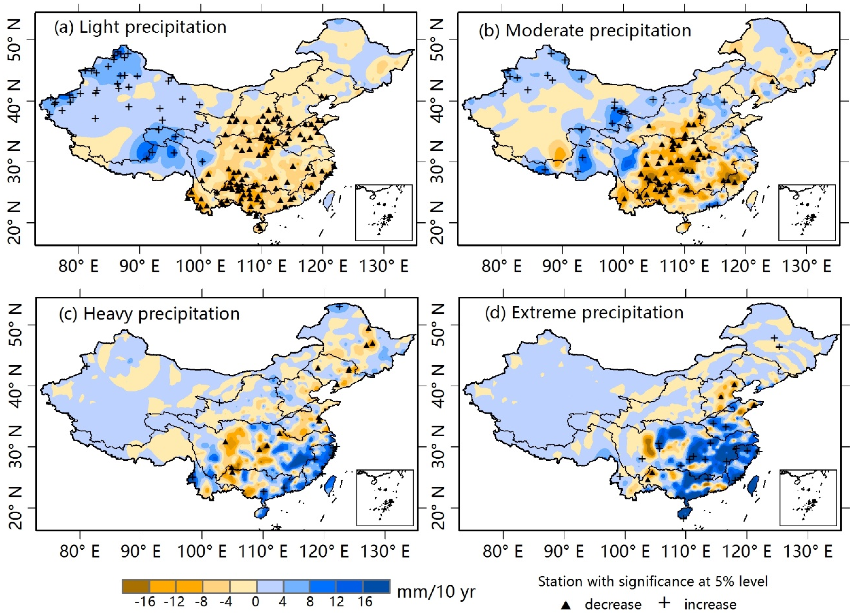
Light precipitation showed a slight decrease (−1.20 mm/10yr) during 1960–2013 (Table 1), but a contrasting pattern of trends emerged across China (Figure 3a). Northwestern rivers, the headwaters of the Yangtze River and Yellow River, and southwestern rivers showed a significant increase, whereas other regions showed a significant decrease (Figure 3a). In the ten river basins, northwestern rivers and southwestern rivers showed an increase in light precipitation over the past half-century, and the trend in northwestern rivers was statistically significant (Table 1). Light precipitation in the Yangtze, Huaihe, and Pearl Rivers showed significant decreases. Data shown in Table 1 further suggest decreases in light precipitation largely contributes to the decrease in annual precipitation in these regions.
A decreasing trend for moderate precipitation was also detected across China (−0.65 mm/10yr, Table 1). Significant decreases occurred from Central to Southern China, including the mid-Yellow River, mid- and downstream Yangtze River, Pearl River, and southeastern rivers (Figure 3b). In the Yangtze River, moderate precipitation showed a significant decrease at a 0.1 significance level (−3.30 mm/10yr), which had a strong influence on the downtrend of annual precipitation (Table 1). Southeastern rivers and Pearl River also displayed large decreases in moderate precipitation (−3.71 mm/10yr and −4.48 mm/10yr, respectively). Significant increases mainly occurred in Northern and Western China (Figure 3b). Northwestern rivers were dominated by a significant increasing trend (0.99 mm/10yr). In the Haihe River, only moderate precipitation showed a positive trend (0.86 mm/10yr), which would partly alleviate the drier conditions over the past half-century.
Heavy precipitation was mainly detected in monsoon regions of China, and stations with significant increases were mostly located in the lower reaches of the Yangtze and Pearl Rivers and the southeastern rivers (Figure 3c). Table 1 shows that heavy precipitation significantly increased in northwestern rivers (0.82 mm/10yr) and southeastern rivers (9.35 mm/10yr), and fluctuated largely in Liaohe River, Huaihe River, and southwestern rivers, although these trends were not statistically significant. Extreme precipitation was mainly detected in the eastern and southeastern coastal regions, and stations with significant increases stretched from southeastern coastal areas to the middle reaches of the Yangtze and Huaihe Rivers (Figure 3d). In the whole country, on average, extreme precipitation showed a significant increase from 1960 to 2013 (1.76 mm/10yr). Regionally, in northwestern rivers, Yangtze River, southeastern rivers, and southwestern rivers, extreme precipitation significantly increased, while in Haihe River a significant decrease was detected (Table 1). The southeastern rivers displayed a large increase in total precipitation (22.21 mm/10yr), which was primarily the result of an increase in extreme precipitation (15.63mm/10yr).
Karl et al. noted that even when there is no change in the total precipitation, the distribution of precipitation events might shift significantly [8]. In this study, the proportion of precipitation falling in each category was sensitive to changes in the distribution of precipitation. Results showed the proportion of light precipitation decreased significantly in nearly whole China over the past half-century (Figure 4a), while moderate precipitation in Northwestern China (Figure 4b) and extreme precipitation in Southeastern China (Figure 4d) significantly increased. On basin scale, a decrease in proportion of light precipitation was detected in most basins except Songhuajiang River and Liaohe River, even though in the northwestern rivers and southwestern rivers, where light precipitation increased from 1960 to 2013 (Table 1). In the Yangtze River and Pearl River, the proportion of moderate precipitation also decreased significantly, mainly resulting from larger percentage of extreme precipitation. The proportion of heavy precipitation increased in nearly all basins except the Songhuajiang River, and the trend was significant in the northwestern rivers, Yellow River, and the southeastern rivers (Table 1). The proportion of extreme precipitation increased in basins locating in Southern China, but decreased significantly in Haihe River, where the distribution of precipitation shifted toward the moderate category (Table 1). Similarly, in Yellow River, the proportion of extreme precipitation also showed decreasing trend, although without significance, and the distribution of precipitation shifted toward the heavy category (Table 1). There was no marked change in the distribution of precipitation in the Songhuajiang River and Liaohe River.
3.2. Seasonal Characteristics of Precipitation Tendencies
Changes in seasonal precipitation over China during 1960–2013 are shown in Figure 5 and the averaged trends in each season over China and its ten large river basins are given in Table 2. In spring (Figure 5a), precipitation increased in Northern and Western China, especially over the southwestern rivers and the headwaters of the Yellow River and Yangtze River. Significant decreases were observed over the middle and lower reaches of the Yangtze River and the middle reaches of the Yellow River (Figure 5a).
In summer, precipitation has markedly changed over the past half-century, showing large uptrends and downtrends with absolute values as large as >16 mm/10yr in most monsoon regions of China (Figure 5b). Specifically, significantly uptrends were observed in the Yangtze River and southeastern rivers, while significant downtrends were observed in Haihe River (Table 2).
Autumn precipitation showed a significant decrease from 1960 to 2013 in the whole of China, as well as in Songhuajiang River and Yangtze River (Table 2). Precipitation increases occurred only in limited areas of the Haihe River, northwestern and southwestern rivers (Figure 5c).
However, in winter, precipitation has increased significantly in China since 1960s, and nearly all basins experienced positive trends; significant in Songhuajiang River, northwestern rivers, and southeastern rivers (Table 2). The increase was more than 8 mm/10yr in the southeastern rivers, downstream areas of the Huaihe River and Yangtze River (Figure 5d).
Comparing changes in annual precipitation (Figure 2) to those in summer precipitation (Figure 5b), we can see that the large increase in summer rainfall in Southeastern China and large decrease in Northeastern and Southwestern China dominated the annual change during 1960–2013. At the basin scale, the strong impact of summer rainfall on annual precipitation change could be found in southeastern rivers and the Haihe River (Table 2). In the Yellow River basin, however, which experienced only small changes in summer rainfall, the annual decreasing trend represented precipitation decreases in the spring and autumn (Table 2). This was also observed in the Yangtze River, Huaihe River, and Pearl River, even though summer rainfall increased in these basins (Table 2). In northwestern rivers, the increase in annual precipitation was the result of increases during all seasons.
3.2.1. Seasonal Precipitation
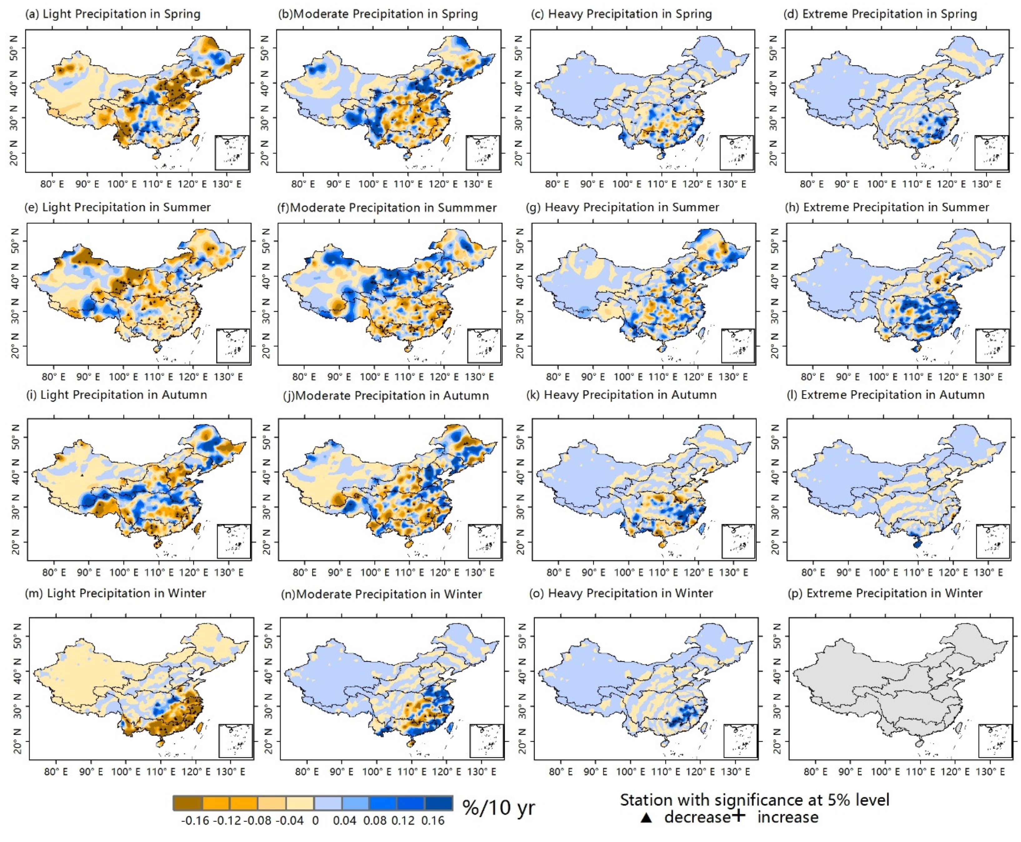
As Figure 6a,b shows, there was less light and moderate precipitation during spring in regions from the mid-Yellow River to the Pearl River. Table 3 shows significant increasing trends in spring precipitation were observed in the Haihe River, northwestern rivers, and southwestern rivers (Table 3). In northwestern rivers, the increase in spring precipitation resulting from increase in light and moderate categories, while in southwestern rivers all categories led to the increase. The significant changes of light precipitation in basins, such as Songhuajiang River, northwestern rivers, Huaihe River, and southeastern rivers, and significant changes of moderate precipitation in basins, such as Liaohe River, Yangtze River, and southeastern rivers dominated changes in spring precipitation in these basins (Table 3). Moreover, in many basins, trends in moderate precipitation made a greater contribution to spring trends than trends in light precipitation.
Heavy and extreme precipitation were also observed in spring; these events occurred mainly in Southeastern China (Figure 6c,d). Specifically, heavy precipitation increased significantly in the Haihe River and southwestern rivers, decreased largely in the Yangtze River and Pearl River, but without significance (Table 3). Stations with significant extreme precipitation increase occurred in southeastern coastal regions (Figure 6d), and there was significant increase in Songhuajiang River, Haihe River, and southwestern rivers (Table 3).
Decreasing trends in light precipitation during the summer were observed in most basins, except for over the northwestern rivers, and moderate precipitation also decreased in many basins, such as Liaohe River, Haihe River, and Pearl River (Table 3). As Figure 6g shows, heavy precipitation increased significantly during the summer over the southeastern rivers, downstream areas of the Yangtze River and in some regions of the Huaihe River and Pearl River. Extreme precipitation occurred mainly in the summer (Figure 6h). The significant increase in extreme precipitation over the southeastern rivers and Yangtze River and significant decrease in Haihe River largely represented the changes in summer rainfall over these regions.
In autumn, both light and moderate precipitation exhibited significant decrease over China, and decreasing trends of light and moderate precipitation were observed in most basins during the study period (Table 3). Moreover Table 3 shows that in the Songhuajiang River, Yellow River, Yangtze River, Huaihe River, and Pearl River, light and moderate precipitation largely represented the overall decrease. Downward trends in heavy autumn precipitation in the Yangtze River, Huaihe River, and Pearl River also contributed to the autumn decrease. In the Haihe River; however, autumn precipitation increased substantially (1.85 mm/10yr), mainly resulting from an increase in moderate precipitation (1.03 mm/10yr).
Figure 6m–p shows winter precipitation trends. Stations that displayed significant trends in moderate and heavy precipitation were only in downstream areas of the Yangtze River and southeastern rivers (Figure 6n,o), while stations was rarely observed with changes in extreme precipitation across China during the past half-century (Figure 6p). Light precipitation increased significantly nearly in the whole country (Figure 6m) and, regionally, significant in Songhuajiang River, northwestern rivers, and Yellow River, which largely explained the increases in winter precipitation over these basins (Table 3). In the southeastern rivers, wetter winter conditions largely derived from increases in moderate and heavy precipitation, and in the Yangtze River and Pearl River, these conditions largely derived from increases in heavy precipitation (Table 3).
3.2.2. Seasonal Distribution
As discussed above, the annual proportion of light precipitation decreased across nearly the whole country; the only regions where it increased were over the Songhuajiang River and Liaohe River, but without significance (Table 1). Seasonally, Table 4 shows the proportional changes in precipitation categories for each basin. For light precipitation, its decreasing proportion was observed across the country in seasons except winter, and was significant in spring and summer (Table 4), even when its amounts were observed to have increased in spring (Table 3). In winter, however, seven of the ten basins still displayed negative trends (Table 4).
In spring, the proportion of moderate, heavy and extreme precipitation all exhibited significant increase over China, as well as in northwestern rivers, Haihe River, and southwestern rivers (Table 4). However, in southeastern rivers, the proportion of moderate precipitation showed significant increase, and the distribution of precipitation shifted toward heavy and extreme categories (Table 4). Besides, the proportion of extreme precipitation increased significantly in Songhuajiang River and Huaihe River (Table 4).
Changes in proportions of summer precipitation categories are shown in Figure 7e–h; these were similar to those representing the whole year. In summer, the proportion of moderate, heavy and extreme precipitation significantly increased across China (Table 4). Light precipitation decreased in proportion nearly across all basins except Haihe River. In the Yangtze River, Huaihe River, southeastern rivers, and Pearl River, the proportion of moderate precipitation decreased significantly over 1960–2013, indicating precipitation became much more intense than basins such as northwestern rivers and Yellow River (Table 4). Contrary to other regions, the Liaohe River, Haihe River, and Yellow River experienced a negative trend in its proportion of extreme summer precipitation.
In winter, the proportion of heavy precipitation significantly increased over China, as well as in Yangtze River, southeastern rivers and Pearl River (Table 4). In Songhuajiang River, northwestern rivers, and Huaihe River, moderate precipitation exhibited significant increase in proportion (Table 4). These suggested the distribution of winter precipitation shifted toward the intense category in these basins. Changes in the distribution of autumn precipitation during the study period were inconspicuous across China. In general, however, decreasing trends in autumn precipitation were observed over nearly the whole of China, as discussed above.
4. Discussion and Conclusion
Long-term changes of precipitation are regarded as a practical subject for monitoring changes in water resources. In China, the result of our study showed that annual precipitation had increased slightly in the past half-century, which was consistent with some previous studies [7,42]. At the basin scale, significant increasing trends over the northwestern rivers was found, while annual precipitation decreased in large amplitude over the Liaohe River, Haihe River, Huaihe River, and Pearl River. Seasonally, Liu et al. found that precipitation had increased in winter and summer but decreased in spring and fall, over 1960–2000 [1]. Our study showed that autumn precipitation significantly decreased, while in spring, precipitation increased by 0.54 mm/10yr across China during the past half-century.
In hydrology, precipitation intensity is an important factor in rainfall-runoff processes [43]. Many studies have shown that over the past several decades, daily precipitation has become more intense in China [1,11,21,44]. In this study, changes in daily precipitation were analyzed by fixed categories. Results from trends in proportion showed the distribution of precipitation significantly shifted toward heavy and extreme precipitation over China. At the basin scale, precipitation intensity significantly increased in basins except Songhuajiang River, Liaohe River, Haihe River, and Yellow River. These increases are consistent the study of Zhang and Cong, which showed that precipitation intensity increased principally in the southern basins of China [11]. Seasonally, the shift in precipitation distribution from light to intense occurred in all seasons, significantly in spring and summer. However, this study showed, in northwestern rivers, precipitation also became more intense than before. Within the ten large basins, only the Haihe River experienced a significant decrease in extreme precipitation, while the proportions of the moderate and heavy categories increased there. In the Yellow and Songhuajiang Rivers, the proportions of the extreme category also decreased, but without significance.
Liu et al. showed that changes in annual precipitation could be attributed mostly to changes in the frequency and intensity of precipitation events in the top decile (90%) in China [1]. Using fixed thresholds, the results of this study showed only in the Haihe River, southeastern rivers, and southwestern rivers, extreme precipitation significantly influenced total precipitation. Furthermore, the impact of extreme precipitation was also obvious in spring, not merely in summer. The results also revealed, however, that changes in light and moderate precipitation also played an important role in the trends observed in the total precipitation in many basins, such as the northwestern rivers and Huaihe River, even in the Yangtze River and Pearl River. Seasonally, the increase in winter precipitation and the decrease in autumn precipitation also mainly derived from changes in the amount of light and moderate precipitation. In hydrology, precipitation in lower intensities also has considerable influence on basic flow, ground water, and so on [43,45]. For example, water infiltration of the soil surface during rainfall tends to be higher during lower-intensity rainfalls [1]. Therefore, significant increases in light precipitation over China during winter, and some basins during spring, could alleviate the dry conditions during the cold seasons in these regions.
China is prone to natural hazards from extreme weather events and flooding has always been a major problem [7]. Recently, numerous studies have documented precipitation extremes in China. Zhai et al. found significant increases in extreme precipitation events in Western China, the mid- and lower reaches of the Yangtze River, and coastal areas of China during 1951–2000 [42]. Xu et al. found that extreme precipitation amounts and extreme precipitation days significantly increased in the mid-and lower Yangtze River valley and Northwestern China [20].In those studies, extreme precipitation derived from percentile thresholds. As discussed above, extreme events by top 5% was just equal to moderate or light precipitation (defined in this study) in Western China. In this study, extreme precipitation is defined by fixed threshold (>50 mm/d), which could be more closely linked to floods. Results showed extreme precipitation in the Yangtze River, southeastern rivers, and southwestern rivers, increased significantly during 1960–2013, indicating a trend toward high risk of floods within these basins, as these basins are relatively developed regions of China with high population densities. What is more, the seasonal changes in extreme precipitation revealed in this study indicate that the risk of floods in some regions may be higher than suggested by previous studies; this should be highlighted in water resources management as follows. (1) Over the Yangtze River and southeastern rivers, a significant increase in extreme precipitation at the annual scale mainly derived from the summer, reflecting extreme events being concentrated in summer. (2) A significant increase in extreme precipitation was observed across the southwestern rivers and Songhuajiang River during spring, and Pearl River during winter, when vegetation cover is sparse and rainfall-runoff processes would be quick and heavy. (3) In the Haihe River, extreme precipitation during spring also significantly increased, although the yearly extreme precipitation showed a marked decrease. (4) However, in northwestern rivers, the increase in precipitation intensity was not related to an increase in the risk of floods over the past half-century, because it mainly resulted from an increase in moderate precipitation.
The amount and distribution of precipitation also play crucial roles in the occurrence of drought. As light precipitation generally occupied a fairly large proportion in rainfall events, a significant decrease in light precipitation over Yangtze, Huaihe, and Pearl Rivers might indicate an increase in dry-spells. Seasonally, autumn precipitation significantly decreased in the Songhuajiang and Yangtze Rivers, which might enhance the possibility of seasonal drought in these regions.
Acknowledgments
This work was supported by the Key Programs of the Chinese Academy of Sciences (KFZD-SW-301-5), the Important Science & Technology Specific Projects of Qinghai Province (2014-NK-A4-1).
Author Contributions
Aifeng Lv conceived the study. Bo Qu performed the data analysis and wrote the paper. Aifeng Lv, Shaofeng Jia and Wenbin Zhu read and edited the manuscript. All authors reviewed and approved the manuscript.
Conflicts of Interest
The authors declare no conflict of interest.
References
- Liu, B.; Xu, M.; Henderson, M.; Qi, Y. Observed trends of precipitation amount, frequency, and intensity in China, 1960–2000. J. Geophys. Res. Atmos. 2005, 110. [Google Scholar] [CrossRef]
- Rodrigo, F.S.; Trigo, R.M. Trends in daily rainfall in the Iberian Peninsula from 1951 to 2002. Int. J. Climatol. 2007, 27, 513–529. [Google Scholar] [CrossRef]
- Field, C.B.; Van Aalst, M. Freshwater resource. In Climate Change 2014: Impacts, Adaptation, and Vulnerability. Part A: Global and Sectoral Aspects; Cambridge University Press: Cambridge, UK; New York, NY, USA, 2014; Volume 1. [Google Scholar]
- Hulme, M.; Osborn, T.J.; Johns, T.C. Precipitation sensitivity to global warming: Comparison of observations with HadCM2 simulations. Geophys Res. Lett. 1998, 25, 3379–3382. [Google Scholar] [CrossRef]
- Karl, T.R.; Knight, R.W. Secular Trends of Precipitation Amount, Frequency, and Intensity in the United States. Bull. Am. Meteorol. Soc. 1998, 79, 231–241. [Google Scholar] [CrossRef]
- Brunetti, M.; Maugeri, M.; Monti, F.; Nanni, T. Changes in daily precipitation frequency and distribution in Italy over the last 120 years. J. Geophys. Res. Atmos. 2004, 109. [Google Scholar] [CrossRef]
- Wu, Y.; Wu, S.Y.; Wen, J.; Xu, M.; Tan, J. Changing characteristics of precipitation in China during 1960–2012. Int. J. Climatol. 2015, 36, 1387–1402. [Google Scholar] [CrossRef]
- Karl, T.R.; Knight, R.W.; Plummer, N. Trends in high-frequency climate variability in the twentieth century. Nature 1995, 377, 217–220. [Google Scholar] [CrossRef]
- Zinke, P.J. Forest interception studies in the United States. In International Symposium on Forest Hydrology; Pergamon Press: New York, NY, USA, 1967; pp. 137–161. [Google Scholar]
- Li, W.; Zhai, P.; Cai, J. Research on the Relationship of ENSO and the Frequency of Extreme Precipitation Events in China. Adv. Clim. Chang. Res. 2011, 2, 101–107. [Google Scholar] [CrossRef]
- Zhang, X.; Cong, Z. Trends of precipitation intensity and frequency in hydrological regions of China from 1956 to 2005. Glob. Planet Chang. 2014, 117, 40–51. [Google Scholar] [CrossRef]
- Chen, Y.; Chen, X.; Ren, G. Variation of extreme precipitation over large river basins in China. Adv. Clim. Chang. Res. 2011, 2, 108–114. [Google Scholar] [CrossRef]
- Su, B.D.; Jiang, T.; Jin, W.B. Recent trends in observed temperature and precipitation extremes in the Yangtze River basin, China. Theor. Appl. Climatol. 2006, 83, 139–151. [Google Scholar] [CrossRef]
- Zhang, Q.; Xu, C.; Gemmer, M.; Chen, Y.D.; Liu, C. Changing properties of precipitation concentration in the Pearl River basin, China. Stoch. Environ. Res. Risk Assess. 2009, 23, 377–385. [Google Scholar] [CrossRef]
- Yang, T.; Shao, Q.; Hao, Z.; Chen, X.; Zhang, Z.; Xu, C.; Sun, L. Regional frequency analysis and spatio-temporal pattern characterization of rainfall extremes in the Pearl River Basin, China. J. Hydrol. 2010, 380, 386–405. [Google Scholar] [CrossRef]
- Shi, W.; Yu, X.; Liao, W.; Wang, Y.; Jia, B. Spatial and temporal variability of daily precipitation concentration in the Lancang River basin, China. J. Hydrol. 2013, 495, 197–207. [Google Scholar] [CrossRef]
- Hu, Y.; Maskey, S.; Uhlenbrook, S. Trends in temperature and rainfall extremes in the Yellow River source region, China. Clim. Chang. 2012, 110, 403–429. [Google Scholar] [CrossRef]
- Vincent, L.A.; Zhang, X.; Bonsal, B.R.; Hogg, W.D. Homogenization of daily temperatures over Canada. J. Clim. 2002, 15, 1322–1334. [Google Scholar] [CrossRef]
- Liu, W.; Fu, G.; Liu, C.; Charles, S.P. A comparison of three multi-site statistical downscaling models for daily rainfall in the North China Plain. Theor. Appl. Climatol. 2013, 111, 585–600. [Google Scholar] [CrossRef]
- Xu, X.; Du, Y.; Tang, J.; Wang, Y. Variations of temperature and precipitation extremes in recent two decades over China. Atmos. Res. 2011, 101, 143–154. [Google Scholar] [CrossRef]
- Gong, D.; Shi, P.; Wang, J. Daily precipitation changes in the semi-arid region over northern China. J. Arid Environ. 2004, 59, 771–784. [Google Scholar] [CrossRef]
- Feng, S.; Hu, Q.; Qian, W. Quality control of daily meteorological data in China, 1951–2000: a new dataset. Int. J. Climatol. 2004, 24, 853–870. [Google Scholar] [CrossRef]
- Mao-chang, C.; Hai, Z.; Shu-min, L.; Arpe, K.; Dumenil, L. Variability of daily precipitation in China (1980–1993): PCA and wavelet analysis of observation and ECMWF reanalysis data. Chin. J. Oceanol. Limnol. 2000, 18, 117–125. [Google Scholar] [CrossRef]
- Svensson, C. Empirical orthogonal function analysis of daily rainfall in the upper reaches of the Huai River basin, China. Theor. Appl. Climatol. 1999, 62, 147–161. [Google Scholar] [CrossRef]
- Qian, W.; Lin, X. Regional trends in recent precipitation indices in China. Meteorol. Atmos. Phys. 2005, 90, 193–207. [Google Scholar] [CrossRef]
- Easterling, D.R.; Evans, J.L.; Groisman, P.Y.; Karl, T.R.; Kunkel, K.E.; Ambenje, P. Observed variability and trends in extreme climate events: A brief review. Bull. Am. Meteorol. Soc. 2000, 81, 417–425. [Google Scholar] [CrossRef]
- Vicente Serrano, S.M.; Beguería, S.; López Moreno, J.I.; García Vera, M.A.; Stepanek, P. A complete daily precipitation database for northeast Spain: Reconstruction, quality control, and homogeneity. Int. J. Climatol. 2010, 30, 1146–1163. [Google Scholar] [CrossRef] [Green Version]
- Brunetti, M.; Maugeri, M.; Monti, F.; Nanni, T. Temperature and precipitation variability in Italy in the last two centuries from homogenised instrumental time series. Int. J. Climatol. 2006, 26, 345–381. [Google Scholar] [CrossRef]
- Wijngaard, J.B.; Klein Tank, A.; Können, G.P. Homogeneity of 20th century European daily temperature and precipitation series. Int. J. Climatol. 2003, 23, 679–692. [Google Scholar] [CrossRef]
- Peterson, T.C.; Easterling, D.R.; Karl, T.R.; Groisman, P.; Nicholls, N.; Plummer, N.; Torok, S.; Auer, I.; Boehm, R.; Gullett, D. Homogeneity adjustments of in situ atmospheric climate data: A review. Int. J. Climatol. 1998, 18, 1493–1517. [Google Scholar] [CrossRef]
- Vincent, L.A. A technique for the identification of inhomogeneities in Canadian temperature series. J. Clim. 1998, 11, 1094–1104. [Google Scholar] [CrossRef]
- Alexandersson, H.; Moberg, A. Homogenization of Swedish temperature data. Part I: Homogeneity test for linear trends. Int. J. Climatol. 1997, 17, 25–34. [Google Scholar] [CrossRef]
- Szentimrey, T. Statistical procedure for joint homogenization of climatic time series. In Proceedings of the 1st Seminar of Homogenisation of Surface Climatological Data, Budapest, Hungary, 6–12 October 1996; pp. 47–62.
- Potter, K.W. Illustration of a new test for detecting a shift in mean in precipitation series. Mon. Weather Rev. 1981, 109, 2040–2045. [Google Scholar] [CrossRef]
- Moberg, A.; Bergström, H. Homogenization of Swedish temperature data. Part III: The long temperature records from Uppsala and Stockholm. Int. J. Climatol. 1997, 17, 667–699. [Google Scholar] [CrossRef]
- Vincent, L.A.; Mekis, E. Changes in daily and extreme temperature and precipitation indices for Canada over the twentieth century. Atmosphere-Ocean 2006, 44, 177–193. [Google Scholar] [CrossRef]
- Kumar, S.; Merwade, V.; Kam, J.; Thurner, K. Streamflow trends in Indiana: Effects of long term persistence, precipitation and subsurface drains. J. Hydrol. 2009, 374, 171–183. [Google Scholar] [CrossRef]
- Yue, S.; Pilon, P.; Phinney, B.; Cavadias, G. The influence of autocorrelation on the ability to detect trend in hydrological series. Hydrol. Process. 2002, 16, 1807–1829. [Google Scholar] [CrossRef]
- Khattak, M.S.; Babel, M.S.; Sharif, M. Hydro-meteorological trends in the upper Indus River basin in Pakistan. Clim. Res. 2011, 46, 103–119. [Google Scholar] [CrossRef]
- Sen, P.K. Estimates of the regression coefficient based on Kendall's tau. J. Am. Stat. Assoc. 1968, 63, 1379–1389. [Google Scholar] [CrossRef]
- Bargaoui, Z.K.; Chebbi, A. Comparison of two kriging interpolation methods applied to spatiotemporal rainfall. J. Hydrol. 2009, 365, 56–73. [Google Scholar] [CrossRef]
- Zhai, P.; Zhang, X.; Wan, H.; Pan, X. Trends in total precipitation and frequency of daily precipitation extremes over China. J. Clim. 2005, 18, 1096–1108. [Google Scholar] [CrossRef]
- Wang, H.; Gao, J.E.; Zhang, M.; Li, X.; Zhang, S.; Jia, L. Effects of rainfall intensity on groundwater recharge based on simulated rainfall experiments and a groundwater flow model. Catena 2015, 127, 80–91. [Google Scholar] [CrossRef]
- Wang, Y.; Zhou, L. Observed trends in extreme precipitation events in China during 1961–2001 and the associated changes in large-scale circulation. Geophys. Res. Lett. 2005, 32. [Google Scholar] [CrossRef]
- Liu, H.; Lei, T.W.; Zhao, J.; Yuan, C.P.; Fan, Y.T.; Qu, L.Q. Effects of rainfall intensity and antecedent soil water content on soil infiltrability under rainfall conditions using the run off-on-out method. J. Hydrol. 2011, 396, 24–32. [Google Scholar] [CrossRef]
Figure 1.
Large river basins and the locations of the 713 meteorological stations evaluated in China.
Figure 1.
Large river basins and the locations of the 713 meteorological stations evaluated in China.
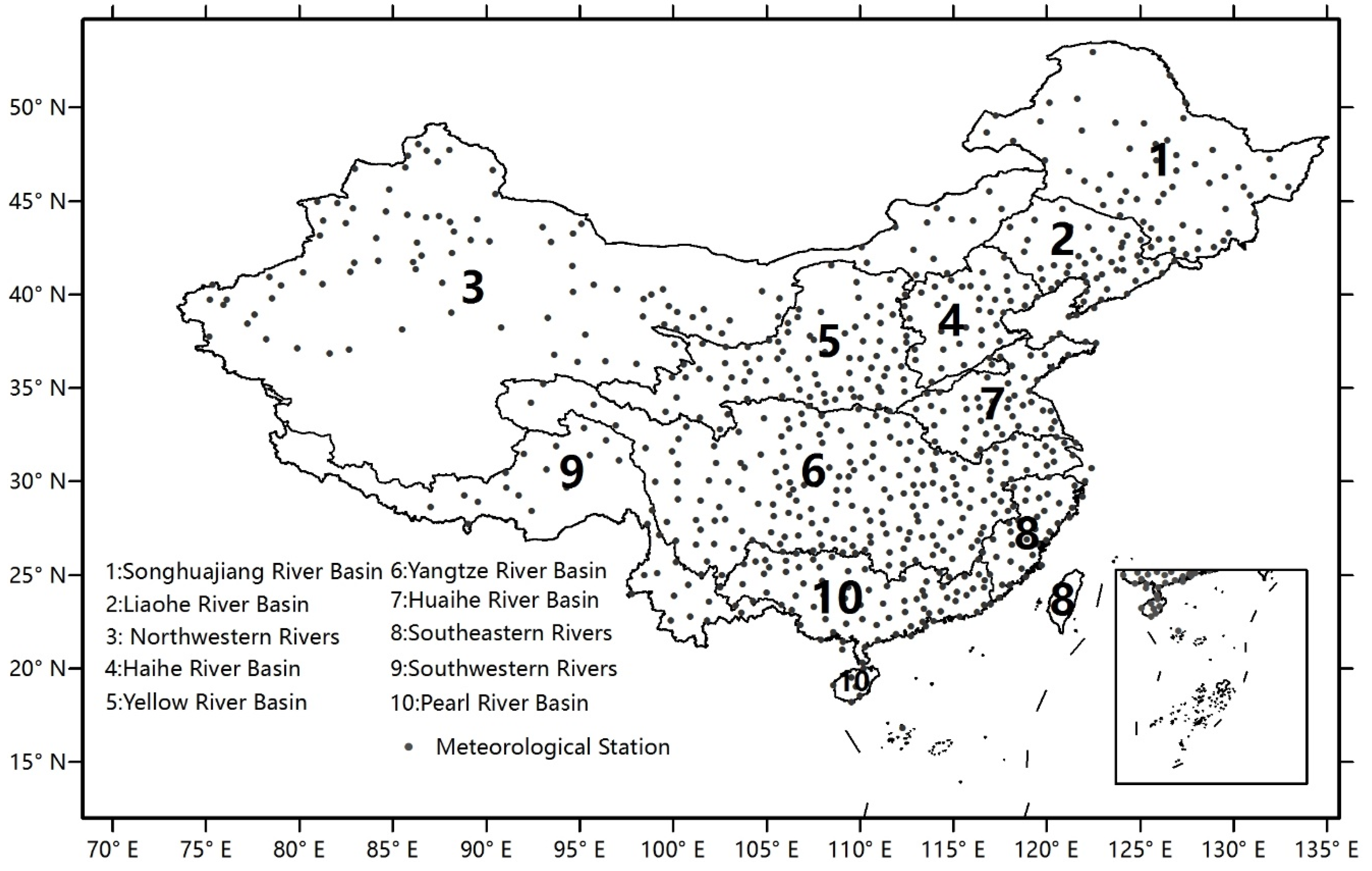
Figure 2.
Trends in annual precipitation for 1960–2013. A plus/triangle shows a positive/negative trend for each station with statistical significance at the 5% level.
Figure 2.
Trends in annual precipitation for 1960–2013. A plus/triangle shows a positive/negative trend for each station with statistical significance at the 5% level.

Figure 3.
Trends in precipitation of each category for 1960–2013. (a) Light precipitation; (b) moderate precipitation; (c) heavy precipitation; and (d) extreme precipitation.
Figure 3.
Trends in precipitation of each category for 1960–2013. (a) Light precipitation; (b) moderate precipitation; (c) heavy precipitation; and (d) extreme precipitation.

Figure 4.
Trends in the proportion of each precipitation category relative to annual precipitation for 1960–2013. (a) Light precipitation; (b) moderate precipitation; (c) heavy precipitation; and (d) extreme precipitation.
Figure 4.
Trends in the proportion of each precipitation category relative to annual precipitation for 1960–2013. (a) Light precipitation; (b) moderate precipitation; (c) heavy precipitation; and (d) extreme precipitation.
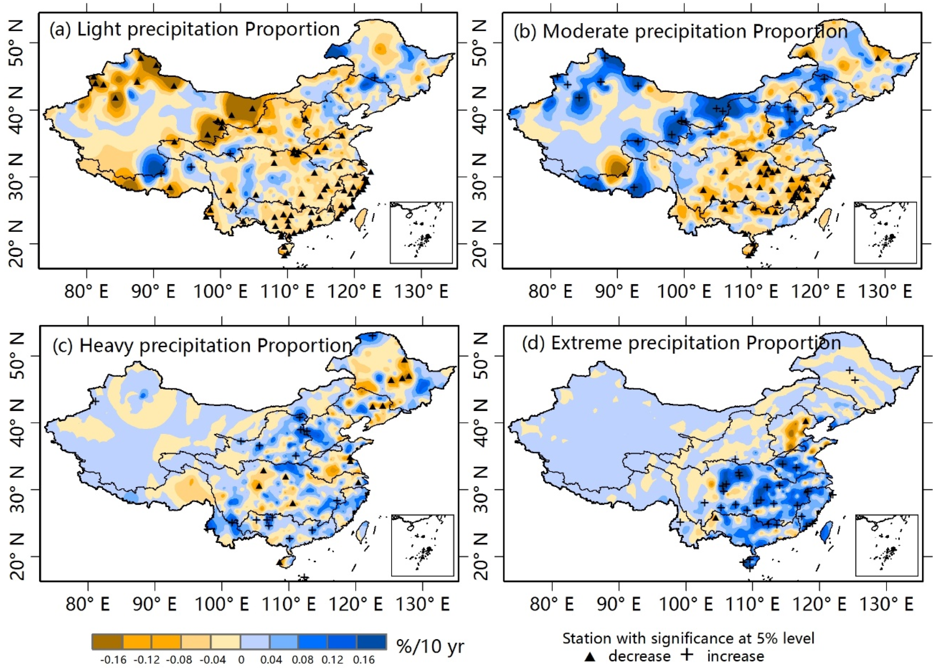
Figure 5.
Trends in seasonal precipitation during 1960–2013. (a) Spring; (b) summer; (c) autumn; and (d) winter.
Figure 5.
Trends in seasonal precipitation during 1960–2013. (a) Spring; (b) summer; (c) autumn; and (d) winter.
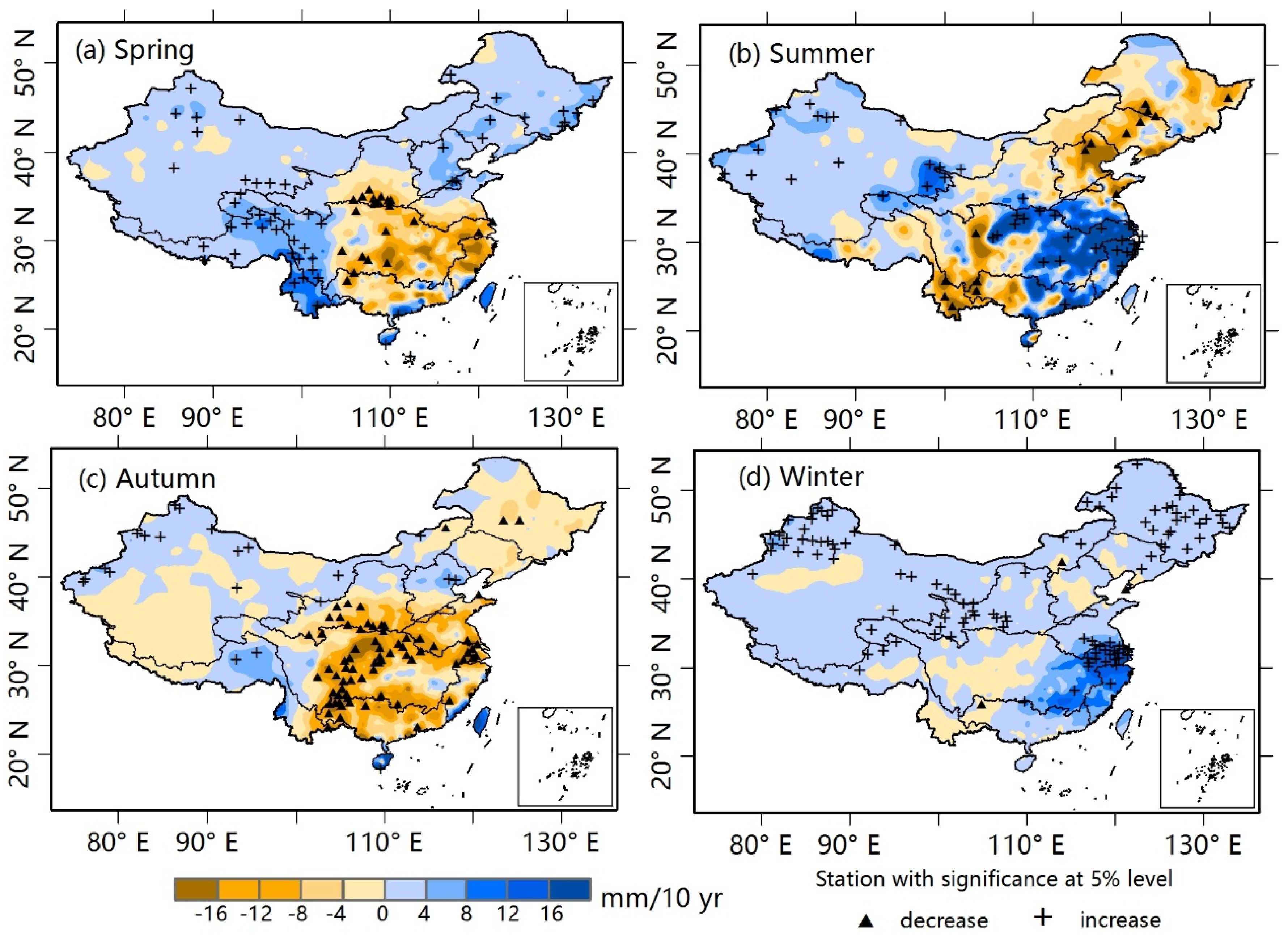
Figure 6.
Seasonal trends in precipitation categories during 1960–2013. (a–d) Spring; (e–h) summer; (i–l) autumn; and (m–p) winter. For each season, the maps show light, moderate, heavy, and extreme precipitation from left to right.
Figure 6.
Seasonal trends in precipitation categories during 1960–2013. (a–d) Spring; (e–h) summer; (i–l) autumn; and (m–p) winter. For each season, the maps show light, moderate, heavy, and extreme precipitation from left to right.
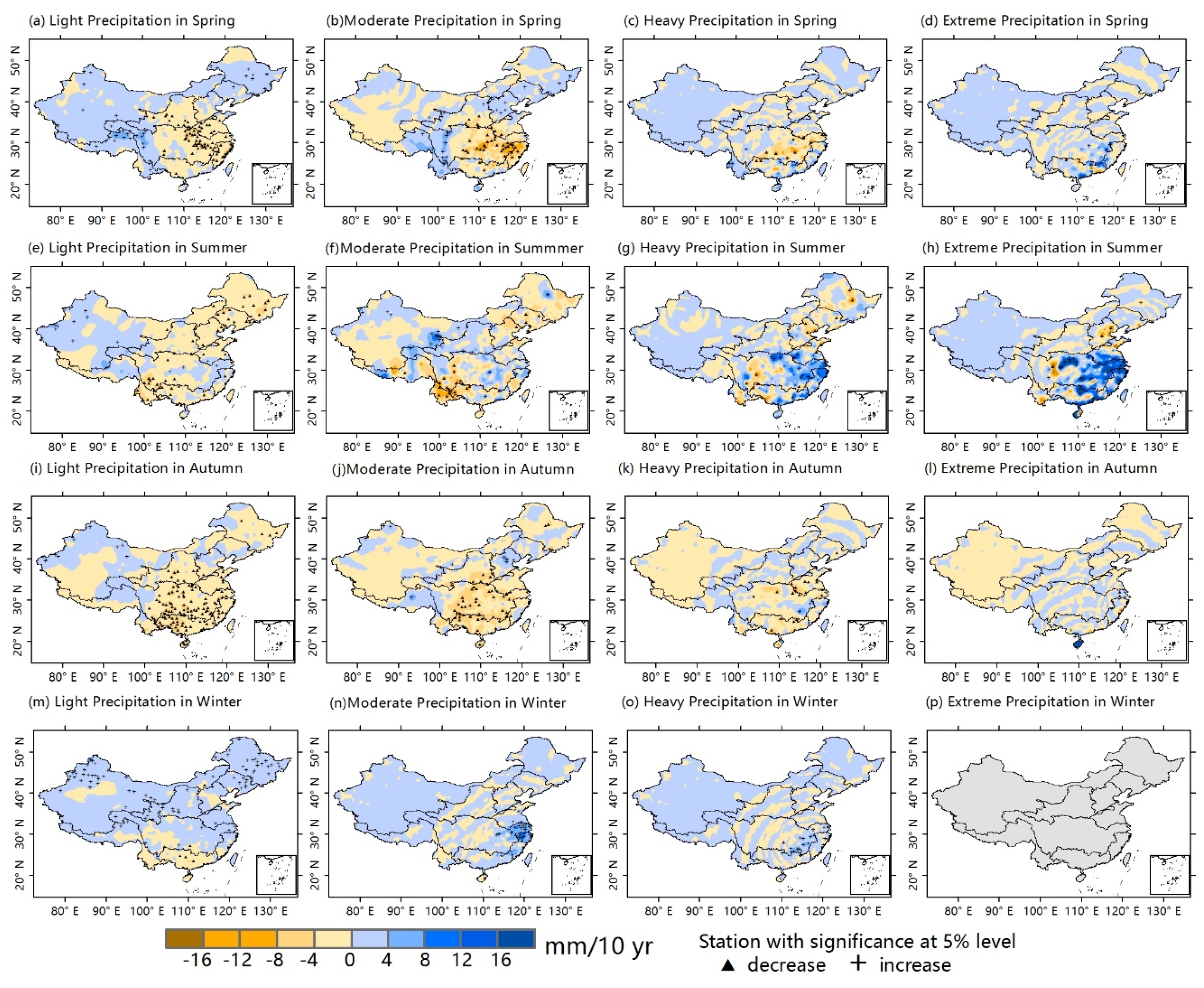
Figure 7.
Seasonal trends in precipitation intensity proportions during 1960–2013. (a–d) Spring; (e–h) summer; (i–l) autumn; and (m–p) winter. For each season, the maps show light, moderate, heavy, and extreme precipitation from left to right.
Figure 7.
Seasonal trends in precipitation intensity proportions during 1960–2013. (a–d) Spring; (e–h) summer; (i–l) autumn; and (m–p) winter. For each season, the maps show light, moderate, heavy, and extreme precipitation from left to right.

Table 1.
Trends in amounts and proportion of precipitation in each category in the large river basins in China during 1960–2013.
| Basin | Amount (mm/10yr) | Proportion (%/10yr) | |||||||
|---|---|---|---|---|---|---|---|---|---|
| Light Rain | Moderate Rain | Heavy Rain | Extreme Rain | Total | Light Rain | Moderate Rain | Heavy Rain | Extreme Rain | |
| Songhuajiang River | −0.01 | −1.65 | −0.57 | 0.20 | −2.89 | 0.25 | −0.10 | −0.06 | 0.00 |
| Liaohe River | −1.68 | −1.48 | −1.80 | −2.48 | −8.60 | 0.13 | 0.12 | 0.05 | −0.29 |
| Northwestern Rivers | 1.44a | 0.99a | 0.41 | 0.32 | 3.69a | −0.68a | 0.37b | 0.13 | 0.02 |
| Haihe River | −1.65 | 0.86 | −0.45 | −4.39b | −5.59 | −0.05 | 0.53b | 0.08 | −0.56b |
| Yellow River | −1.73 | −1.44 | 0.61 | −0.31 | −2.69 | −0.45 | 0.12 | 0.33b | −0.05 |
| Yangtze River | −2.28b | −3.30b | 0.61 | 3.88b | −1.13 | −0.22b | −0.28a | 0.08 | 0.45a |
| Huaihe River | −3.08a | −1.24 | −1.80 | −1.10 | −7.20 | −0.31a | −0.01 | 0.04 | 0.47 |
| Southeastern Rivers | −3.94 | −3.71 | 9.35b | 15.63a | 22.21 | −0.48a | −0.52 | 0.34a | 0.71a |
| Southwestern Rivers | 1.44 | 1.04 | 2.14 | 1.84b | 5.29 | −0.43a | 0.19 | 0.12 | 0.13a |
| Pearl River | −5.44a | −4.48 | 0.39 | 5.00 | −5.71 | −0.23a | −0.24a | 0.04 | 0.34b |
| All China | −0.41 | −0.65 | 0.47 | 1.76b | 1.10 | −0.39a | 0.06 | 0.15a | 0.15a |
a Significance at 95% level; b Significance at 90% level; Unit “mm/10yr” and “%/10yr” means mm and % per decade.
| Basin | Spring | Summer | Autumn | Winter | Annual |
|---|---|---|---|---|---|
| Songhuajiang River | 2.03 | −4.90 | −2.16a | 1.33a | −2.89 |
| Liaohe River | 2.21 | −7.75 | −3.42 | 0.17 | −8.60 |
| Northwestern rivers | 0.97b | 1.36 | 0.33 | 0.75a | 3.69a |
| Haihe River | 4.91a | −12.53a | 1.85 | −0.18 | −5.59 |
| Yellow River | −0.62 | −0.84 | −3.38 | 0.34 | −2.69 |
| Yangtze River | −3.35 | 6.68b | −6.15a | 2.56 | −1.13 |
| Huaihe River | −1.48 | 3.30 | −7.60 | 1.86 | −7.20 |
| Southeastern rivers | −5.14 | 15.99b | 0.55 | 7.37a | 22.21 |
| Southwestern rivers | 5.72a | −2.70 | 0.59 | −0.09 | 5.29 |
| Pearl River | −4.27 | 0.94 | −9.47 | 2.11 | −5.71 |
| All China | 0.54 | 0.10 | −2.76 | 1.26 | 1.10 |
a Significance at 95% level; b Significance at 90% level.
Table 3.
Seasonal trends of precipitation intensity over China’s large river basins during 1960–2013 (mm/10yr).
| Season | Intensity | Songhuajiang River | Liaohe River | Northwestern Rivers | Haihe River | Yellow River | Yangtze River | Huaihe River | Southeastern Rivers | Southwestern Rivers | Pearl River | All China |
|---|---|---|---|---|---|---|---|---|---|---|---|---|
| Spring | Light rain | 1.02b | 0.56 | 0.43b | 0.28 | −0.56 | −0.69 | −1.67a | −2.52a | 1.21a | −0.82 | 0.11 |
| Moderate rain | 0.84 | 1.29a | 0.31b | 1.93a | −0.11 | −1.95a | −0.87 | −5.89a | 1.93a | −1.71 | −0.15 | |
| Heavy rain | 0.03 | 0.35 | 0.13 | 1.15a | 0.16 | −1.53 | −0.20 | 0.05 | 1.34a | −1.28 | 0.02 | |
| Extreme rain | 0.11a | 0.08 | 0.15 | 0.28a | −0.02 | 0.40 | 0.95 | 2.66 | 0.89a | −0.66 | 0.36 | |
| Total | 2.03 | 2.21 | 0.97b | 4.91a | −0.62 | −3.35 | −1.48 | −5.14 | 5.72a | −4.27 | 0.54 | |
| Summer | Light rain | −2.21a | −2.28a | 0.23 | −1.58a | −0.56 | −0.23 | −0.74b | −0.23 | −0.36 | −1.22b | −0.57b |
| Moderate rain | −2.12 | −2.05b | 0.52b | −2.71b | 0.49 | 0.19 | 0.06 | −0.27 | −1.83 | −2.13 | −0.60 | |
| Heavy rain | −1.22 | −1.01 | 0.33 | −2.08 | −0.19 | 1.44 | 2.63 | 6.05a | −0.79 | 0.67 | 0.29 | |
| Extreme rain | 0.06 | −2.49 | 0.36 | −5.12b | −0.53 | 4.79a | 2.95 | 8.88b | 0.55 | 5.16 | 0.88b | |
| Total | −4.90 | −7.75 | 1.36 | −12.53a | −0.84 | 6.68b | 3.30 | 15.99b | −2.70 | 0.94 | 0.10 | |
| Autumn | Light rain | −0.53 | −0.48 | 0.20 | −0.17 | −1.46b | −1.95a | −1.81b | −1.42 | −0.19 | −3.55a | −0.86a |
| Moderate rain | −0.97 | −0.52 | −0.03 | 1.03 | −1.44 | −3.04a | −1.88 | −0.77 | 0.28 | −3.54a | −1.09a | |
| Heavy rain | −0.31 | −0.90 | 0.02 | 0.39 | 0.05 | −1.01 | −3.33b | 0.58 | 0.23 | −3.09 | −0.38 | |
| Extreme rain | −0.03 | −0.19 | 0.05 | 0.37 | −0.43b | −0.59 | −0.40 | 1.90 | 0.18 | 0.29 | −0.06 | |
| Total | −2.16 | −3.42 | 0.33 | 1.85 | −3.38 | −6.15a | −7.60 | 0.55 | 0.59 | −9.47 | −2.76a | |
| Winter | Light rain | 1.12a | 0.36 | 0.53a | 0.01 | 0.38b | 0.46 | 1.00 | 0.17 | −0.03 | −1.21 | 0.38b |
| Moderate rain | 0.18a | 0.03 | 0.05 | −0.01 | −0.01 | 0.63 | 1.11 | 3.75b | −0.10 | 1.00 | 0.27 | |
| Heavy rain | 0.05 | 0.00 | 0.03 | −0.01 | −0.01 | 1.15a | 0.04 | 3.08b | 0.24 | 1.93a | 0.44a | |
| Extreme rain | 0.00 | 0.00 | 0.02 | −0.01 | 0.00 | 0.09 | 0.00 | 0.52b | 0.01 | 0.55b | 0.09 | |
| Total | 1.33 | 0.17 | 0.75 | −0.18 | 0.34 | 2.56 | 1.86 | 7.37 | −0.09 | 2.11 | 1.26 |
a Significance at 95% level; b Significance at 90% level.
Table 4.
Seasonal trends in precipitation intensity proportions over China’s large river basins during 1960–2013 (%/10yr).
| Season | Intensity | Songhuajiang River | Liaohe River | Northwestern Rivers | Haihe River | Yellow River | Yangtze River | Huaihe River | Southeastern Rivers | Southwestern Rivers | Pearl River | All China |
|---|---|---|---|---|---|---|---|---|---|---|---|---|
| Spring | Light rain | −0.28 | −1.93a | −0.51 | −3.00a | −0.58 | −0.13 | −1.35b | −0.49b | −1.17a | 0.14 | −0.59a |
| Moderate rain | 0.46 | 1.05b | 0.68a | 1.49a | 0.42 | 0.04 | −0.05 | −0.58a | 0.91a | −0.29 | 0.40a | |
| Heavy rain | −0.24 | 0.34 | 0.11 | 1.14a | 0.39 | −0.03 | 0.40 | 0.45b | 0.23b | 0.00 | 0.13b | |
| Extreme rain | 0.04a | 0.08 | 0.02 | 0.21a | 0.02 | 0.27 | 0.87a | 0.66b | 0.17b | 0.17 | 0.16a | |
| Summer | Light rain | −0.14 | −0.08 | −1.17a | 0.05 | −0.32 | −0.35a | −0.32b | −0.32a | −0.14 | −0.26b | −0.56a |
| Moderate rain | 0.03 | 0.17 | 0.76a | 0.19 | 0.41b | −0.29a | −0.31b | −0.61a | 0.14 | −0.42a | 0.30a | |
| Heavy rain | 0.04 | 0.24 | 0.14 | 0.22 | 0.13 | 0.08 | 0.13 | 0.28 | 0.05 | 0.05 | 0.16a | |
| Extreme rain | 0.08 | −0.28 | 0.09 | −0.47 | −0.11 | 0.54a | 0.58 | 0.64 | 0.14b | 0.65b | 0.15b | |
| Autumn | Light rain | 0.29 | 0.60 | −0.52 | −0.97 | −0.09 | 0.06 | 0.33 | −0.77b | −0.67b | −0.26 | −0.16 |
| Moderate rain | −0.38 | 0.14 | 0.23 | 0.98b | −0.15 | −0.27 | 0.44 | −0.12 | 0.48b | −0.06 | 0.05 | |
| Heavy rain | −0.14 | −0.18 | 0.02 | 0.43 | 0.59b | 0.13 | −1.07a | 0.17 | 0.07 | −0.34 | 0.06 | |
| Extreme rain | −0.03 | −0.06 | 0.05 | 0.22 | −0.17 | 0.14 | −0.04 | 0.66 | 0.06 | 0.42 | 0.09 | |
| Winter | Light rain | −0.36a | 0.44 | 0.55 | −0.03 | −0.10 | −0.24 | −1.07 | −1.88a | 1.10b | −1.95b | −0.16 |
| Moderate rain | 0.29a | 0.12 | 0.14b | 0.03 | 0.11 | −0.19 | 1.66b | 0.58 | 0.10 | 0.18 | 0.14 | |
| Heavy rain | 0.03 | 0.00 | 0.05 | −0.02 | 0.00 | 0.35a | 0.10 | 1.21b | 0.12 | 1.19a | 0.20a | |
| Extreme rain | 0.00 | 0.00 | 0.01 | 0.00 | 0.00 | 0.02 | 0.00 | 0.21 | 0.01 | 0.29a | 0.03 |
a Significance at 95% level; b Significance at 90% level.
© 2016 by the authors; licensee MDPI, Basel, Switzerland. This article is an open access article distributed under the terms and conditions of the Creative Commons Attribution (CC-BY) license (http://creativecommons.org/licenses/by/4.0/).
Share and Cite
MDPI and ACS Style
Qu, B.; Lv, A.; Jia, S.; Zhu, W. Daily Precipitation Changes over Large River Basins in China, 1960–2013. Water 2016, 8, 185. https://doi.org/10.3390/w8050185
AMA Style
Qu B, Lv A, Jia S, Zhu W. Daily Precipitation Changes over Large River Basins in China, 1960–2013. Water. 2016; 8(5):185. https://doi.org/10.3390/w8050185
Chicago/Turabian StyleQu, Bo, Aifeng Lv, Shaofeng Jia, and Wenbin Zhu. 2016. "Daily Precipitation Changes over Large River Basins in China, 1960–2013" Water 8, no. 5: 185. https://doi.org/10.3390/w8050185
Note that from the first issue of 2016, this journal uses article numbers instead of page numbers. See further details here.