1. Introduction
According to the World Disaster Report [
1], seismic events killed the greatest number of people of all natural hazards in recent years, averaging 50,184 people per year from 2000 to 2008, whereas flood events affected the largest number of people, averaging 99 million people per year between 2000 and 2008. Haiti, currently rated as the poorest country in the Western hemisphere, is vulnerable to both of these natural hazards. In January 2010, a 7.0 magnitude earthquake struck Port-au-Prince, the capital of Haiti. It caused more than 300,000 deaths and left more than 1.5 million people homeless [
2]. Only two years later, Hurricane Isaac crossed the southern peninsula of Haiti bringing flooding and storms to areas affected by the earthquake of 2010. As many as 5000 people were evacuated due to the flooding and 180 earthquake refugee camps were affected [
3]. Due to the lack of disaster preparedness, the 2010 earthquake also led to an extensive resettlement process in which an estimated 500,000 people spontaneously left the capital and sought refuge in other provinces [
4]. This process led to the formation of numerous informal settlements in previously uninhabited areas.
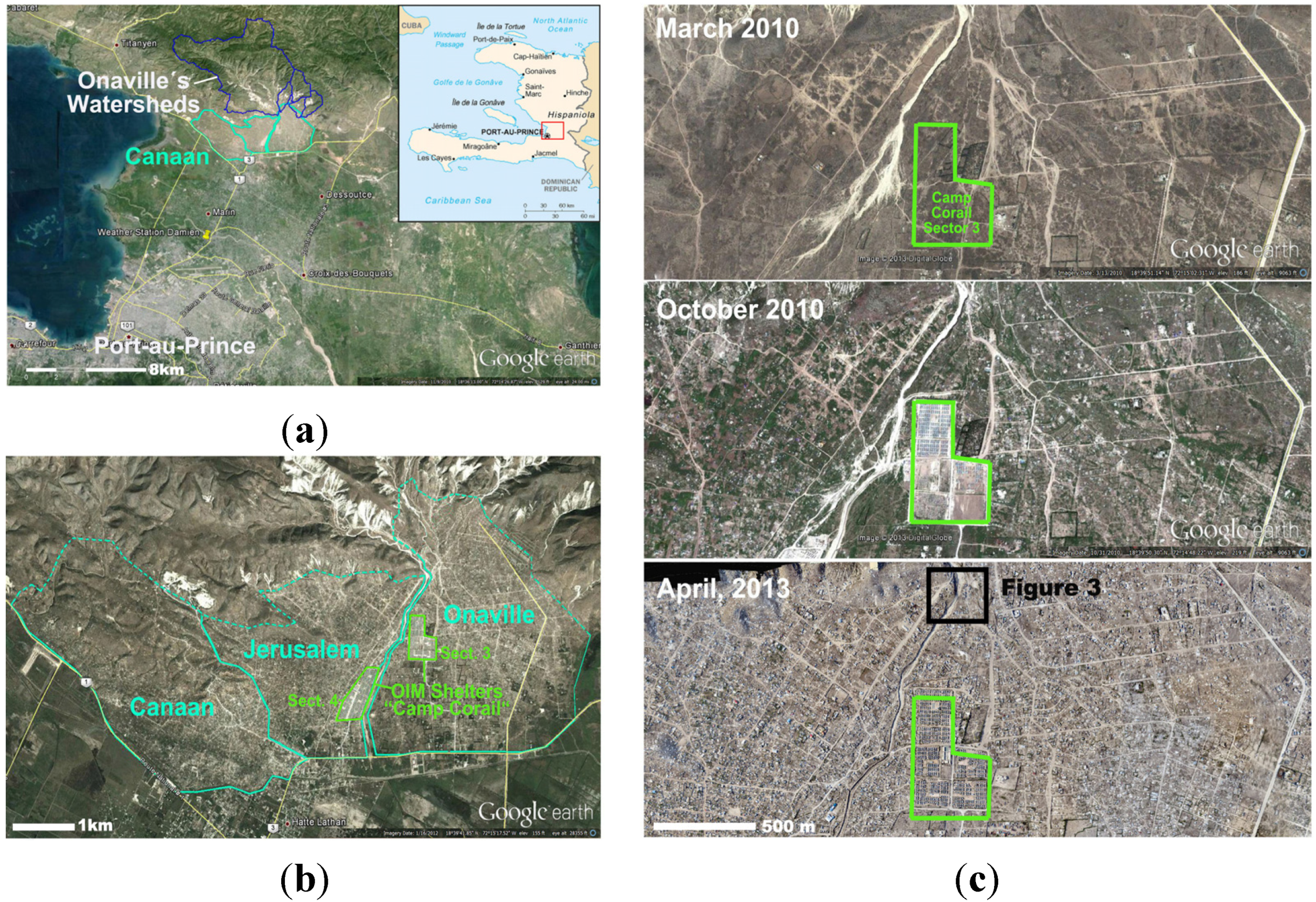
The area of Canaan north east of Port-au-Prince is a good example for this resettlement process. In order to address overcrowded refugee camps in acute risk of flooding in the capital, internally displaced people (IDP) camps were constructed in the previously uninhabited area of Canaan (
Figure 1). Since then, Canaan has grown in an uncontrolled way and meanwhile, transformed into an increasingly urban settlement with likely more than 100,000 residents [
5].
Figure 1.
(
a) Location of Canaan in Haiti; (
b) Location of Camp Corail and Onaville in Canaan; (
c) settlement process of Onaville between 2010 and 2013 [
6].
Figure 1.
(
a) Location of Canaan in Haiti; (
b) Location of Camp Corail and Onaville in Canaan; (
c) settlement process of Onaville between 2010 and 2013 [
6].
The overall aim of this study was to perform a state-of-the-art flood risk analysis for Onaville by addressing the difficult socio-economic situation and the lack of readily available data through a variety of innovative approaches. The study was conducted in the frame of the Technical University of Munich (TUM) research project Urban Strategies for Onaville (TUM-USO) [
7], in which researchers from different backgrounds as well as the non-governmental Organization (NGO) TECHO, currently active in Haiti, collaborate with local stakeholders in planning and implementing strategies for sustainable development of the settlement.
Previous studies indicate that parts of Onaville are currently at high risk of being affected by flooding [
8,
9]. The state-of-the-art to handle such natural hazards is to establish a defined procedure for handling risks like Flood Risk Management (
Figure 2), which is the process of managing an existing flood risk situation which, beside the assessment and mitigation of flood risk, includes a continuous and holistic societal analysis [
10]. The technical part for a functioning flood risk management and for preparing a decision basis is risk assessment, which comprises understanding, evaluating and interpreting the perceptions of risk and societal tolerances of risk [
11]. Risk assessment for floods is based on hazard maps, which are part of the risk analysis process, a methodology to objectively determine risk by analyzing and combining probabilities and consequences [
10].
Figure 2.
Elements of operational (flood) risk management, adapted from Plate [
11].
Figure 2.
Elements of operational (flood) risk management, adapted from Plate [
11].
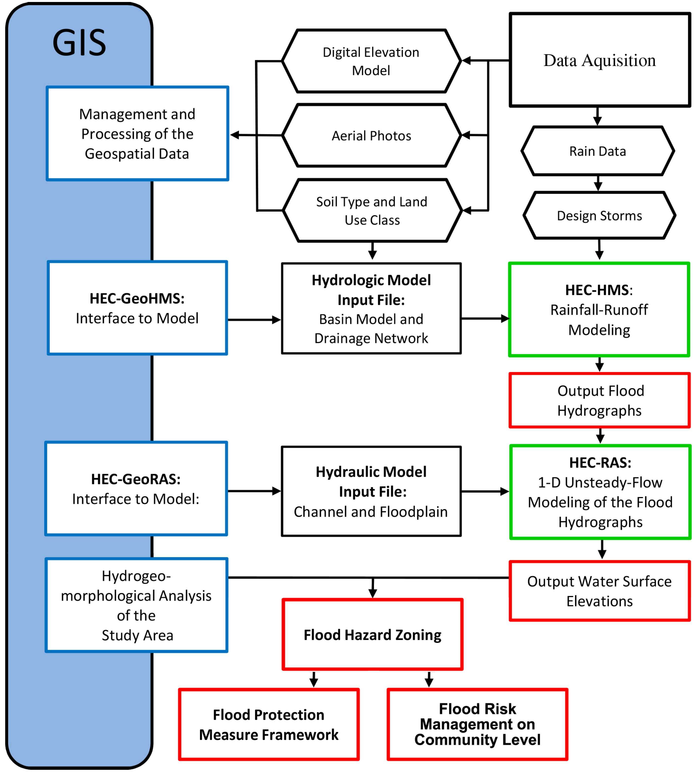
In the case of remote and impoverished settlements, one of the main challenges is commonly the acquisition of sufficient regional, hydraulic, hydrological and meteorological data for the risk assessment. Additionally, it is crucial to assess the socio-economic situation of the study area in detail (Vulnerability analysis-risk determination) and to establish information channels to the residents of the settlement in order to communicate the risk situation and to improve disaster preparedness. Therefore, this study is focused on the materials and methods that are necessary to establish a functioning risk assessment for informal settlements located in remote, impoverished and data sparse areas like Onaville.
Based on the available data, a suitable modeling approach had to be found, which would allow performing the risk analysis while simultaneously serving as a flood risk management and planning tool. Since no records about the runoff characteristics of the rivers and watersheds that affect the Onaville settlement exist, rainfall-runoff modeling was used in combination with subsequent hydraulic modeling to estimate the flood hazard of Onaville and to create a flood hazard map as a basis for flood risk management. In such a coupled modeling approach, the annual exceedance probability (AEP) related to the magnitude of flood events is determined based on the AEP of the design storms used as the input to the rainfall-runoff model. The design storms were generated based on existing IDF curves, which are derived from several decades of rainfall measurements and thus represent the local long-term rainfall characteristics.
Based on the encountered flood hazard situation, a grassroots approach for improving risk awareness and disaster preparedness in the complex socio-economic setting of Onaville is presented that is expected to be applicable to other informal settlements with similar risk situations. The main challenge for implementing a functioning risk management for the study area was the poor socio-economic state of the unplanned settlement, its political status and the uncertainties related to future urban development.
4. Results and Discussion
4.1. Hydrologic Modeling Results
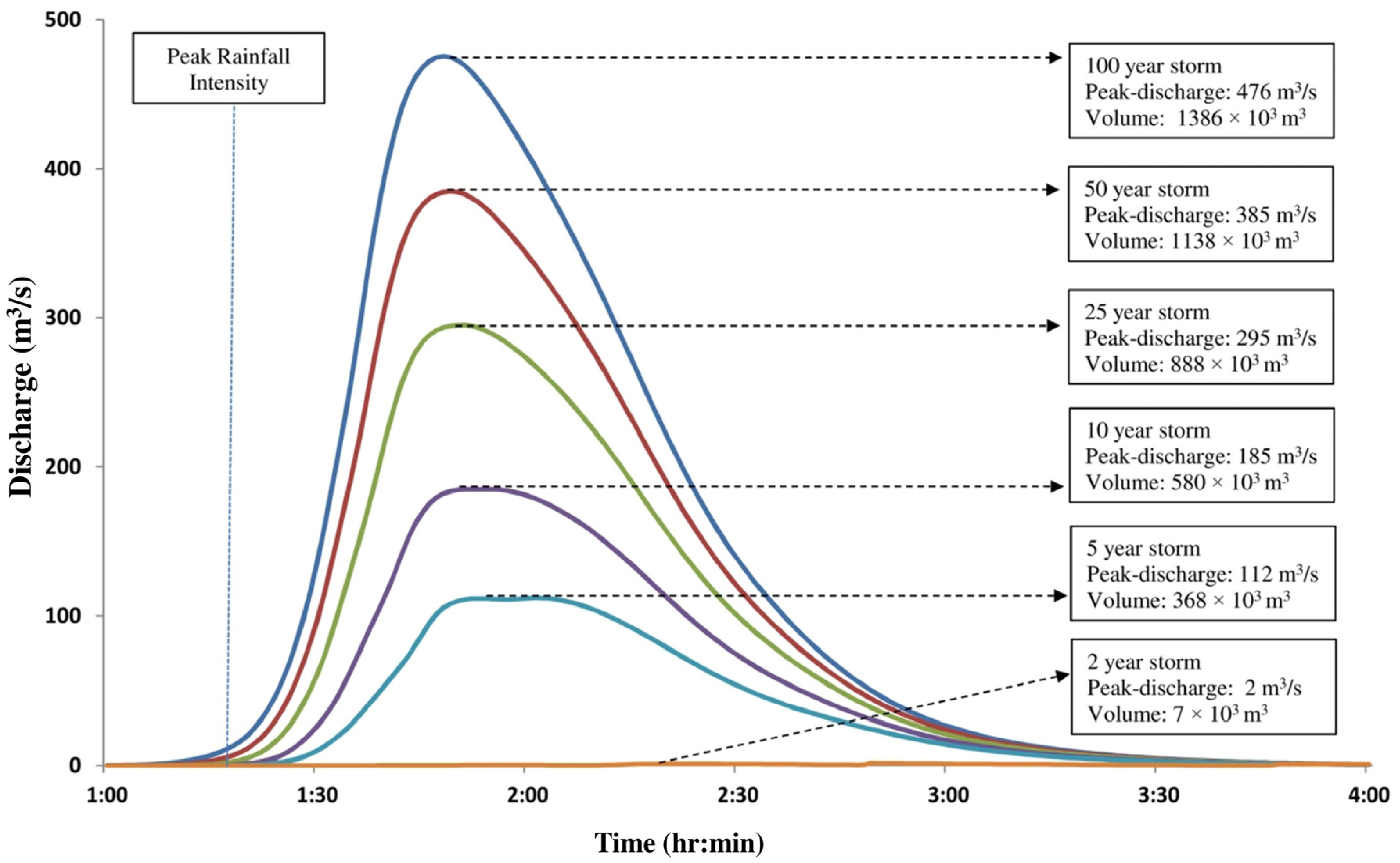
Figure 15 shows the design floods resulting from rainfall-runoff modeling of the design storms. It can be seen that a design storm with an ARI of two years only leads to a peak discharge of 2 m
3/s in the Ravine Lan Couline whereas a storm with an ARI of five years already leads to a peak discharge of 112 m
3/s. This is in accordance with the fact that no significant discharges have been seen in the ravine since the beginning of urban development in the area in 2010 (Interviews with local residents by members of TUM-USO). Even though this observation could not be verified due to the lack of historic data, it strengthens the prediction of the model that the Ravine Lan Couline watershed only produces runoff in response to larger precipitation events. Furthermore, it is seen that exceptional storms with short durations and very high intensities can be expected to produce large peak runoffs of up to more than 400 m
3/s (ARI = 100 years) and more than 300 m
3/s (ARI = 50 years). Considering the relatively small size of the analyzed watershed (25.8 km
2), discharges of more than 400 m
3/s seem very high at first. The shape of the hydrographs, however, is typical for flash flood events as the result of short and intense rainfalls in mountainous watersheds. The high rainfall intensities that the study area experiences in combination with the short time of concentration of the analyzed watershed leads to the steep and short rising limb of the flood hydrographs as well as a short overall duration of the flood.
Figure 15.
Flood hydrographs with ARIs of two to 100 years (Ravine Lan Couline).
Figure 15.
Flood hydrographs with ARIs of two to 100 years (Ravine Lan Couline).
4.2. Hydraulic Modeling Results
Based on the hydrographs resulting from rainfall-runoff modeling (
Figure 15), unsteady flow simulations were performed for ARIs of five, 25 and 100 years.
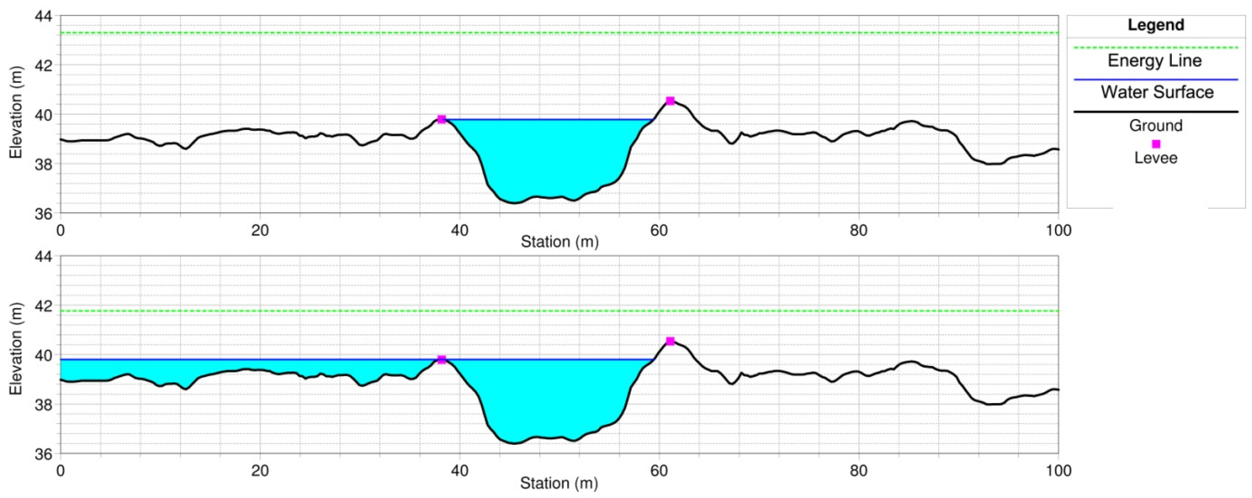
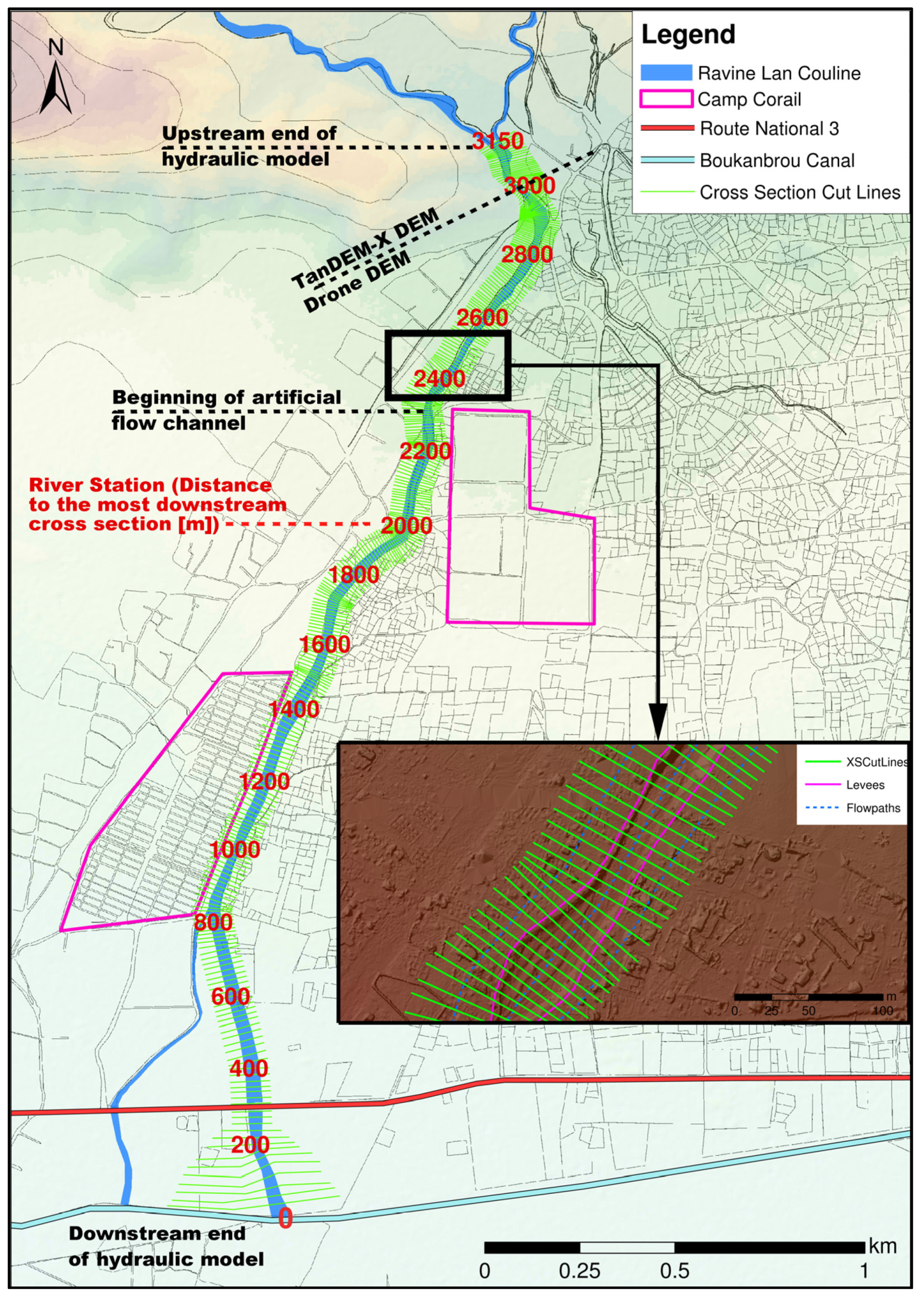
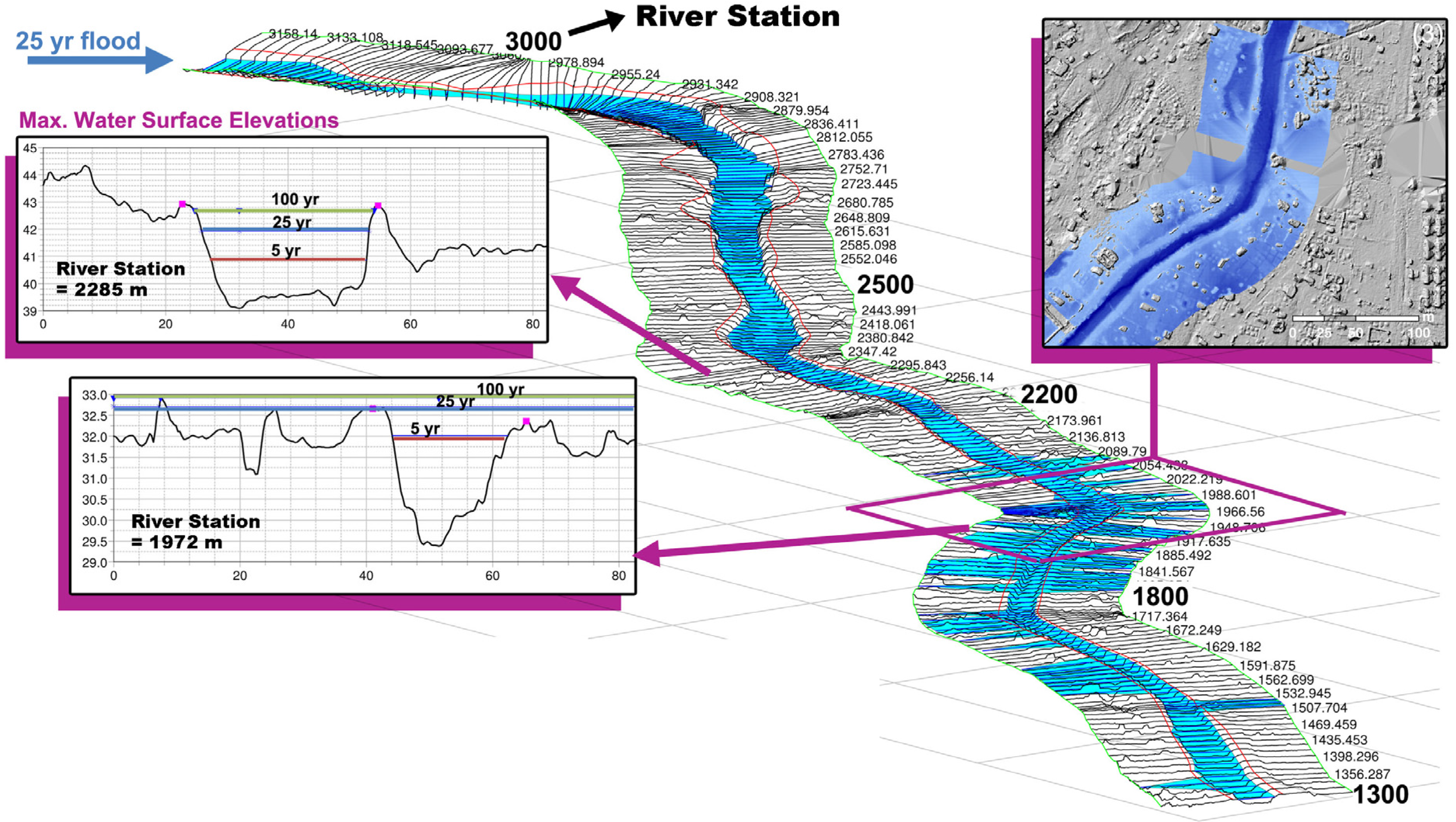
Figure 16 illustrates the hydraulic modeling results in form of a three-dimensional view of the maximum water surface resulting from a 25 year ARI design flood, which was chosen as this is the lowest ARI where levee overtopping occurs. Additionally, the modeling results for ARIs of five, 25 and 100 years are shown in the form of cross-section views for two locations along the channel (river station 2258 and 1972). The river station is used to locate cross sections along the modeled reach and is defined as the distance to the downstream end of the modelled reach in meters. An overview of the entire reach that was modelled along with the river stations was given in
Figure 14.
The artificial flow channel constructed along with Camp Corail roughly begins at river station 2350. The maximum water surface resulting from the peak discharge of the five year ARI flood runoff shows that the bottleneck fraction of the channel is roughly located between river station 1800 and 2000. In this area, levee overtopping occurs first during the rise of the flood wave. The cross section at river station 2285 (
Figure 16) is representative for the beginning section of the artificial flow channel. The stability of the levees in this section is questionable, since they are entirely constructed from unconsolidated material excavated from the channel invert and clearly deviate from state-of-the-art levee design standards [
29]. It is therefore expected that the levee cannot resist the 25 and 100 year ARI flood runoffs so that lateral outflow is likely to occur in this area at the right overbank in downstream direction. It is further estimated that the levees in this area are capable of resisting the five year ARI flood runoff because in this case the maximum water level is in the area of the foot of the levee (
Figure 16). The cross section at river station 1972 represents the beginning of the bottleneck fraction of the channel. It can be observed that the peak discharge during the five year ARI flood almost fills up the main channel so that larger discharges are likely to cause lateral outflow in this section. The cross sections located downstream represent the channel in the area of the northern extent of southern Camp Corail. It is obvious that the flow carrying capacity of the channel is significantly larger here than at the bottleneck section, since the 25 year ARI flood peak discharge is conveyed within the main channel.
Figure 16.
Maximum water surface for a 25 year ARI flood in 3D view and for a five, 25 and 100 year ARI flood for two channel cross sections (river station 2285 and 1972).
Figure 16.
Maximum water surface for a 25 year ARI flood in 3D view and for a five, 25 and 100 year ARI flood for two channel cross sections (river station 2285 and 1972).
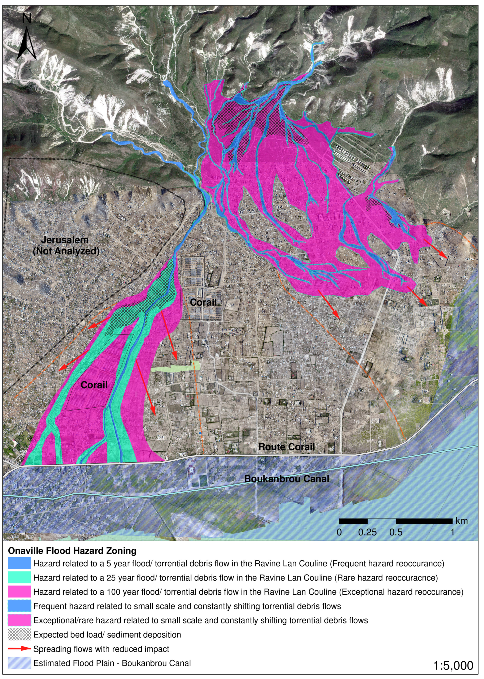
4.3. Flood Hazard Zoning
In order to provide a practical overview of the outcome of the hydrologic and hydraulic modeling as a basis for the flood risk assessment, the results were incorporated into a flood hazard zoning (
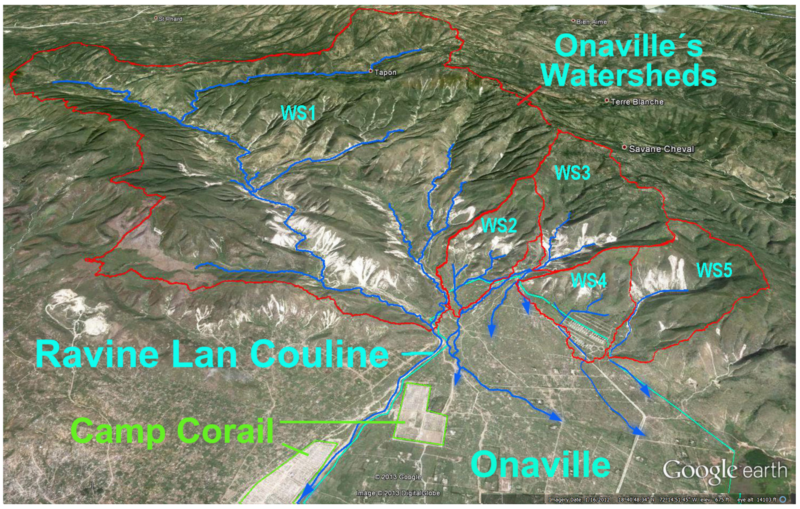
Figure 17). It is important to note that a hazard zoning in comparison to a flood risk zoning does not account for the potential economic and social damages resulting from flooding. The hazard map is intended to provide an easy to understand overview of the flood hazard situation in Onaville. Following the basic structure of European flood hazard maps, the zoning outlines areas based on the ARI of flood events. The zoning can further be separated into areas potentially affected by large flood runoffs or torrential debris flows in Ravine Lan Couline and areas affected by smaller scale, torrential debris flows generated in the other four watersheds in the north of Onaville (see WS 2–5 in
Figure 11). For the latter, hydraulic modeling was not performed as part of this study, since the Drone DEM did not provide sufficient coverage for the network of channels through which these smaller watersheds are draining.
To realize a more understandable zoning especially for non-professionals, the flood discharges with ARIs of five, 25 and 100 years in this study were defined as frequent, rare and exceptional hazard. In case of the Ravine Lan Couline, areas of all of these discharges were outlined. For the rest of the settlement, hazard zones were only categorized into frequent and exceptional hazards. Since hydraulic modeling was limited to locating hydraulic deficiencies of the Ravine Lan Couline channel and did not provide information about the propagation of the flood wave on the alluvial cone, a hydro-geomorphologic analysis of the area was used for the completion of the hazard zoning. Such a combined approach is common practice for the development of flood hazard maps, and was based on the following datasets:
The main steps in generating the hazard zonation were as follows. Before the construction of the artificial flow channel, the propagation of floods over the alluvial cone was easily traceable on historic aerial imagery and the DEMs. The hydraulic modeling showed clearly, where overbank flow and levee breaching is to be expected first during large flood events. Floods in a five year ARI range can be conveyed safely by Ravine Lan Couline through the entire settlement. Floods in a 25 year ARI range exceed the flow carrying capacity of the artificial flow channel at the bottleneck section and are expected to lead to levee breaching right at the beginning of the artificial channel (see cross section at river station 2285 in
Figure 16). Therefore, the zone of rare hazard essentially represents the propagation of floods before the construction of the artificial flow channel along two distinct and relatively wide longitudinal depressions in the alluvial cone in the area of southern Camp Corail. Since a levee breach will lead to a large increase of the flow area and a resulting decrease in flow velocity, bed load deposits are expected in the area of the breach as indicated in the map. The zone of exceptional hazard was created by gradually extending the rare zone towards more elevated areas using the DEMs.
Figure 17.
Flood hazard map of Onaville and the eastern part of Jerusalem (Canaan).
Figure 17.
Flood hazard map of Onaville and the eastern part of Jerusalem (Canaan).
Interviews with residents of northern Onaville revealed that the additional four smaller watersheds frequently produce smaller scale flash flood events carrying large amounts of solids. All four watersheds drain through a clearly visible network of relatively small drainage channels that are carved into the alluvial cone, thereby allowing a good estimation of the propagation of flood discharges through the settlement (
Figure 17). The frequently affected zone was defined based on the currently visible drainage channel network. The rare zone was defined by using the DEM and by considering that the existing drainage channel network is likely to change over time with new channels emerging potentially in areas with similar but not higher elevation than the current channel network. Due to a reduction of the channel slopes along the various flow channels, these concentrated flows eventually spread out on the alluvial cone so that their impact is expected to decrease drastically from this point on. Therefore, areas that are expected to experience spreading flows are outlined separately in the map.
Overall, the flood hazard map shows that large areas in Onaville are exposed to flood hazards. The artificial part of the Ravine Lan Couline channel was found to provide protection only to flood events in the frequent hazard range. Flood events of rare and exceptional hazard range exceed the capacity of the channel and are thus expected to cause severe flooding in the outlined urbanizing areas.
4.5. Discussion
Considering the insufficient database, the predominantly empirical rainfall-runoff models can be seen as highly suitable for the generation of the design flood hydrographs. Although mainly physically-based water balance models like WaSiM or MIKE SHE are state-of-the-art in simulating the rainfall-runoff process, the suitability of such models for the given situation is limited due to the lack of data. To realize an accurate parameterization of such models regional distributed land use and soil data in high resolution are necessary as well as measured rainfall and runoff data for model calibration. Furthermore, the additional features of such physically based models (e.g., simulation of infiltration rates, evapotranspiration or interception) were not needed in this study and their validation would not have been feasible because of the limited data. In order to increase the reliability of the modeling results, measured precipitation and runoff in at least hourly resolution would have been necessary. For this study, information about the runoff behavior of the analyzed watercourses was based on the statements of the inhabitants only, so that a validation of the modeling results with measured data was not possible. Therefore, the modeling results should be interpreted as an approximation of the flood events that may occur in this region.
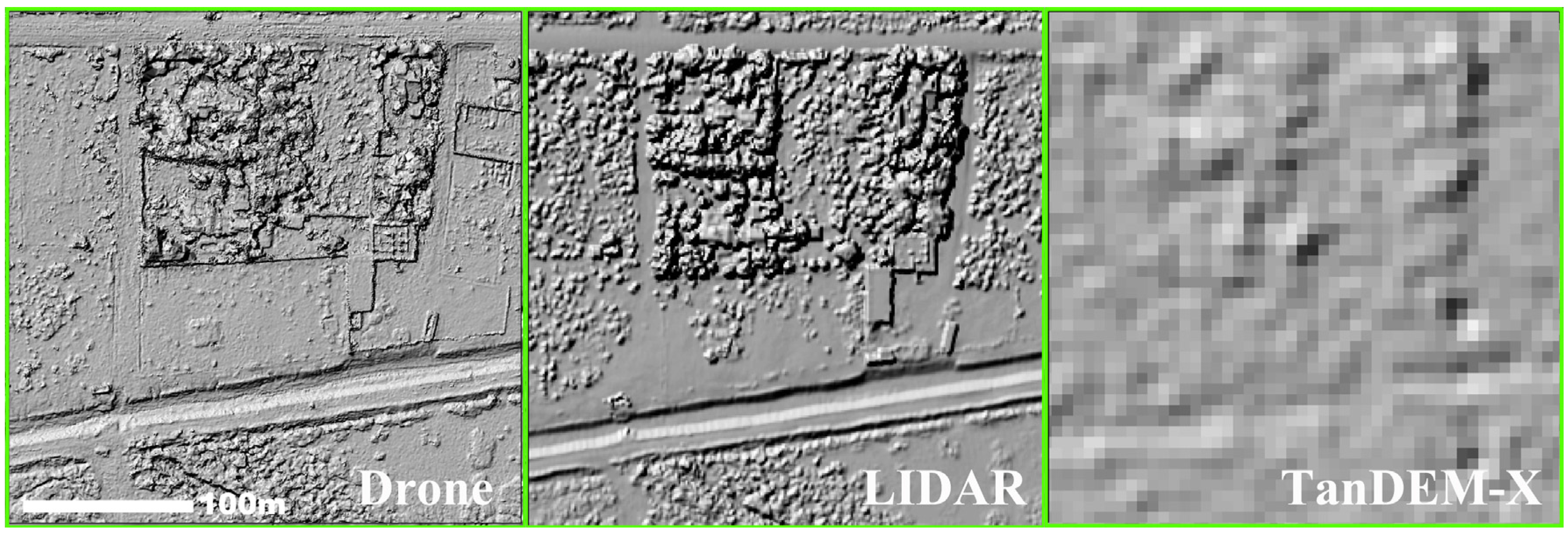
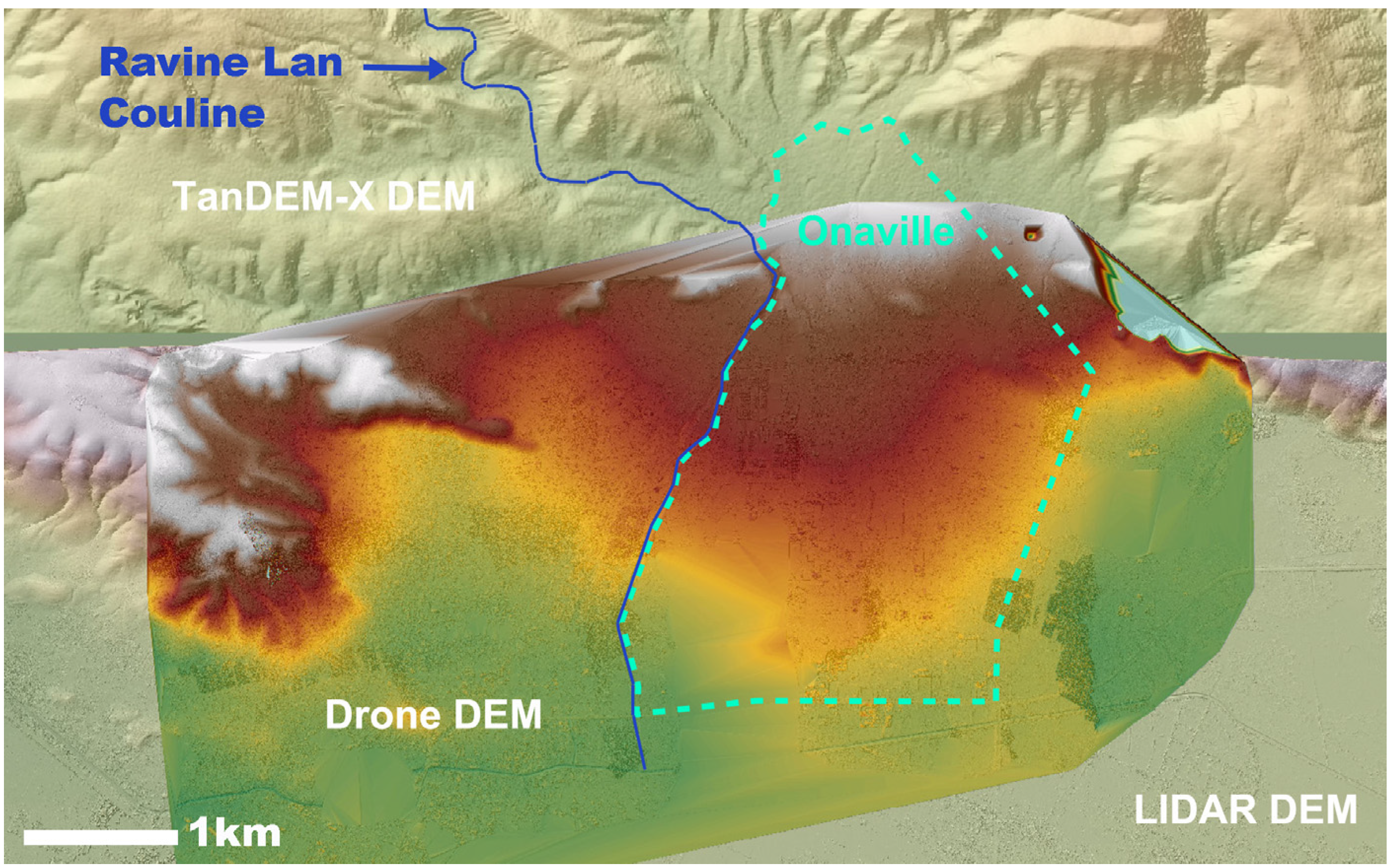
In contrast to this, the acquired data can be considered as suitable for generating the river channel through the settlements in HEC-RAS in a widely realistic way. Only in the northern part of the modeled reach, the TanDEM-X DEM had to be adjusted manually, because of the lower resolution of this DEM compared to the Drone DEM. Since the model is able to simulate the relevant water levels and locate the overflowing sections of the Ravine Lan Couline, it is definitely suitable to accurately estimate the flood hazard situation in the study region.
Despite the good suitability of the topographic data, the applied one-dimensional routing model shows obvious deficits regarding the simulation of lateral outflow of water from the main channel and the flow on the overbank areas, because the model is limited to simulating flow perpendicular to each channel cross section. For accurate modeling of lateral overbank flow, a two-dimensional modeling approach (e.g., HYDRO_AS-2D, MIKE-FLOOD) would be preferable. However, the development and manual correction of the model geometry based on a combination of the Drone DEM and the TanDEM-X DEM, would have been difficult for the 2D modeling approach. The Drone DEM has a number of small areas with poor representation of the terrain, which was easily adjustable for the cross sections in the 1D flow model. These difficulties would have made the development of a 2D flow model complex so that it would have exceeded the scope of this analysis.
Hydrologic and hydraulic modeling revealed that large areas of the settlement are currently exposed to a high level of flood related hazard. The artificial channel was found to mark the beginning of the high-risk zones. Before the artificial channel, the Ravine Lan Couline channel has enough capacity to convey a 100 year ARI flood runoff safely. Lateral outflow of flood runoff in the area of the market place of Onaville (see location of
Figure 3 as referenced in
Figure 1) as predicted by previous studies, is unlikely. The constructed channel, however, only provides protection against flood events in the frequent hazard range. Hydraulic modeling showed that flood events in the rare and exceptional hazard range are likely to have a devastating impact on the settlement in this area. Large amounts of flood runoff leaving the main channel as a result of levee overtopping and breaching have to be expected along with high flow velocities and bed load depositions in the settlement. In general, Sector 4 of Camp Corail is likely to be more vulnerable to flooding than Sector 3. Besides flood runoffs in the Ravine Lan Couline, runoffs generated in the other four examined watersheds also pose flood hazards to certain areas of the settlement. These smaller scale flow events have an unpredictable nature regarding their flow path through the settlement along with high destructive potential as a result of the high solid loads.
Due to a variety of uncertainties in the rainfall-runoff modelling and the incorporation of the hydraulic modelling results into the flood hazard map, the hazard zones have to be seen as a first approximation of the actual hazard situation. The ARIs of the flood events that are outlined in the hazard map have to be proven in more detail by acquiring additional data and applying state-of-the-art process based models. Developing a 2D hydraulic model is recommended since such a model could potentially lead to better estimates of the areas that will be affected by floods in the 25 and 100 year ARI range, if solid transport and deposition can be accurately accounted for.
Based on the GIS and simulation results, the methodology of bringing academic knowledge and technical aspects of flood risk assessment in the form of “applied science” back to local neighborhoods has turned out to be successful. The participants of community workshops were trained with technical, site-specific, methodological and important background knowledge as well as with the skills to come up with low-tech, low-cost solutions, which are applicable on the individual, family or neighborhood level. Yet, until this point in time, only a relatively small group of individuals has been able to benefit from that due to the fact that the undertaken activities were not up-scaled and the leader network was not reinforced.
5. Conclusions and Outlook
5.1. Key Issues and Solutions
One of the key issues related to the fulfillment of the study goals was found to be the acquisition of adequate hydrologic and topographic data. Hereby, the lack of readily available data related to the poor socio-economic state of Haiti was overcome by acquiring data generated by state-of-the-art remote sensing technologies and on-site analyses. The extensive data acquisition process lead to a database that was sufficient to set up a combined-hydrological and hydraulic-conceptual model approach. This leads to the next key issue which was found to be the limited suitability of the one-dimensional HEC-RAS model for the given situation. Even though the model was capable of evaluating the hydraulic capacity and deficiencies of the Ravine Lan Couline channel, a detailed simulation of the propagation of flows outside the main channel was not possible. In addition to that, the geometry of the hydraulic model had to be created based on two separate DEMs. Due to the insufficient spatial resolution of TanDEM-X DEM the cross sections that were derived from this DEM were manually adjusted based on the examination of the channel geometry on high-resolution aerial images.
5.2. Flood Risk Management and Future Work
Considering the available data sets and the selected modeling approach, the flood hazard zonation can be seen as a rough determination of the actual hazard situation that the settlement is facing. Since the presented zonation is at the moment by far the most accurate estimation of the flood hazard situation for the study area, it can be seen as a suitable basis for establishing a functioning flood risk management for Onaville. More complex risk assessments from governmental side are, as a result of the ongoing informal character of the settlement, rather unlikely. To realize a substantially complete operational flood risk management system, a flood protection frame work including designed technical and non-technical flood mitigation measures has to be generated in the next steps. For this, more data have to be collected concerning e.g., runoff data as well as the characteristics, the stability and erosion tendency of soils. Furthermore, the existing circumstances in this region have to be checked to ensure that only feasible measures are taken into account.
The third pillar of modern risk management strategies is prevention and preparedness, which comprises behavioral-, constructional- and risk-based prevention. The flood hazard map presented in this study provides a solid basis for preventive management, which was undertaken in the course of this study on the community as follows:
Skills and technical training of local community leaders
Initiation of an awareness-raising campaign and conceptualization of a local contingency plan
Network-building among local leaders and between these leaders and external national and
International organizations and entities
Development of community-driven risk mitigation measures
This strategy for flood risk management on the community level is mainly based on an established focus group on environmental hazards and a network of local flood risk representatives. It is a reliable, low-cost and highly autonomous basis for risk prevention and mitigation, as it can incorporate resources and information dissemination networks of the community. It could additionally help the (local) authorities to become better prepared and react faster to unforeseeable disasters on a local scale.
Even though the flood hazard map along with the ongoing community work is a big step towards a functioning flood risk management for Onaville, this study has shown that there is an urgent need for further planning and implementation of flood protection measures and a more centralized and integrated flood risk management strategy. In this context, an Onaville-wide upscaling and reinforcement of the Neighborhood Contingency Plan activities is highly recommended, as different stakeholders have already been involved in the first pilot phase, and very positive feedback for the community-driven working methodology of the leader-led focus group has been reported by international and national entities and the community. The organizing focus group of the Neighborhood Contingency Plan should be immediately supported in its grassroots approach to bundle energies and capacities of this volunteer initiative before they are replaced by disillusion. Additionally, the campaign should be backed by technological prevention infrastructure such as the construction of simple weather stations in the hills of Onaville, and discharge gauge instruments at crucial points of the major water course Ravine Lan Couline. As for the emergency plan in general, the leader network needs to be reinforced by involving other established community leaders such as local and national experts, local teachers, pastors and so on. The network has to be supported in collecting and regularly evaluating experiences in the execution of alerts. Additionally, a site-specific assessment of available shelter structures and their surroundings ought to be required in a further step to assure the safety of the location.


